West Pullman neighborhood in Chicago, Illinois (IL), 60628, 60643 detailed profile
Settings
X

Business Search - 14 Million verified businesses
Area: 3.642 square miles
Population: 27,585
Population density:
| West Pullman: | 7,575 people per square mile |
| Chicago: | 11,734 people per square mile |

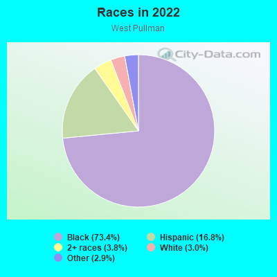
- 23,25773.4%Black
- 5,33816.8%Hispanic or Latino
- 1,1963.8%Two or more races
- 9623.0%White
- 9342.9%Some other race
Distribution of median household income
![Distribution of median household income]()
- 1,513Less than $10,000
- 1,799$10,000 to $19,999
- 2,049$20,000 to $29,999
- 1,528$30,000 to $39,999
- 1,455$40,000 to $49,999
- 1,148$50,000 to $59,999
- 832$60,000 to $74,999
- 1,613$75,000 to $99,999
- 706$100,000 to $124,999
- 902$125,000 to $149,999
- 1,322$150,000 to $199,999
- 326$200,000 or more

Distribution of owner-occupied house/condo value
![Distribution of owner-occupied house/condo value]()
- 2,088Less than $50,000
- 3,743$50,000 to $99,999
- 2,210$100,000 to $149,999
- 1,740$150,000 to $199,999
- 1,194$200,000 to $249,999
- 299$250,000 to $299,999
- 894$300,000 to $399,999
- 2,554$400,000 to $499,999
- 9$500,000 to $749,999
- 354$750,000 to $999,999
- 602$1,000,000 or more

Distribution of rent paid by renters
![Distribution of rent paid by renters]()
- 321Less than $100
- 101$100 to $199
- 2,382$200 to $299
- 2,279$300 to $399
- 1,580$400 to $499
- 897$500 to $599
- 2,160$600 to $699
- 2,633$700 to $799
- 1,326$800 to $899
- 1,025$900 to $999
- 1,364$1,000 to $1,249
- 861$1,250 to $1,499
- 985$1,500 to $1,999
- 1,239$2,000 or more

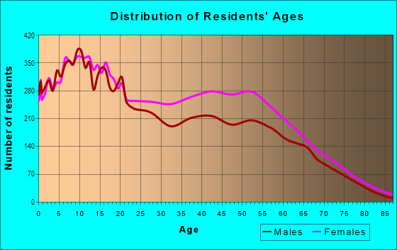
| Males: | 12,818 |
| Females: | 14,766 |
Males:
| This neighborhood: | 37.8 years |
| Whole city: | 35.3 years |
| This neighborhood: | 41.9 years |
| Whole city: | 36.2 years |
Average household size:
| West Pullman: | 4.6 people |
| Chicago: | 2.3 people |
Percentage of family households:
| West Pullman: | 39.4% |
| Chicago: | 36.7% |
| Here: | 23.1% |
| Chicago: | 30.4% |
Percentage of married-couple families with children (among all households):
| West Pullman: | 16.2% |
| Chicago: | 24.1% |
Percentage of single-mother households (among all households):
| West Pullman: | 29.0% |
| Chicago: | 16.0% |
Percentage of never married males 15 years old and over:
Percentage of never married females 15 years old and over:
| West Pullman: | 24.1% |
| Chicago: | 24.5% |
Percentage of never married females 15 years old and over:
| West Pullman: | 28.0% |
| city: | 24.9% |
Percentage of people that speak English not well or not at all:
| West Pullman: | 2.1% |
| Chicago: | 7.1% |
Percentage of people born in this state:
Percentage of people born in another U.S. state:
Percentage of native residents but born outside the U.S.:
Percentage of foreign born residents:
| Here: | 78.6% |
| Chicago: | 58.6% |
Percentage of people born in another U.S. state:
| West Pullman: | 16.0% |
| Chicago: | 18.8% |
Percentage of native residents but born outside the U.S.:
| Here: | 1.7% |
| city: | 2.1% |
Percentage of foreign born residents:
| Here: | 6.4% |
| Chicago: | 20.6% |
Owner-occupied
Renter-occupied

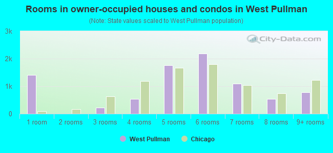
- Rooms in owner-occupied houses and condos in West Pullman
- 1,4141 room
- 62 rooms
- 2293 rooms
- 5344 rooms
- 1,7685 rooms
- 2,1846 rooms
- 1,0947 rooms
- 5458 rooms
- 7709+ rooms
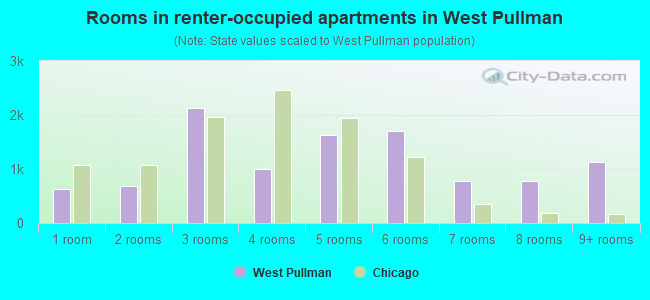
- Rooms in renter-occupied apartments in West Pullman
- 6241 room
- 6832 rooms
- 2,1283 rooms
- 9964 rooms
- 1,6365 rooms
- 1,6956 rooms
- 7737 rooms
- 7858 rooms
- 1,1279+ rooms
Owner-occupied
Renter-occupied
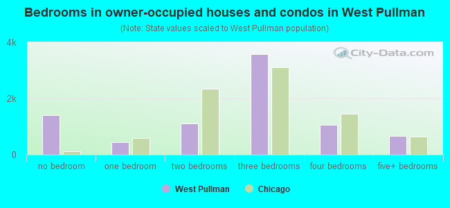
- Bedrooms in owner-occupied houses and condos in West Pullman
- 1,414no bedroom
- 4521 bedroom
- 1,1042 bedrooms
- 3,5913 bedrooms
- 1,0654 bedrooms
- 6605+ bedrooms
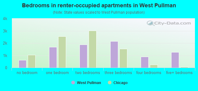
- Bedrooms in renter-occupied apartments in West Pullman
- 624no bedroom
- 1,6691 bedroom
- 1,8702 bedrooms
- 2,1443 bedrooms
- 8924 bedrooms
- 1,2625+ bedrooms
Average number of cars or other vehicles available in houses/condos:
Average number of cars or other vehicles available in apartments:
| This neighborhood: | 1.8 |
| Chicago: | 1.5 |
Average number of cars or other vehicles available in apartments:
| Here: | |
| city: |
Percentage of units with a mortgage:
| West Pullman: | 55.8% |
| Chicago: | 64.7% |
Average estimated value of detached houses in 2022 (62.1% of all units):
| West Pullman: | $701,821 |
| Chicago: | $393,455 |
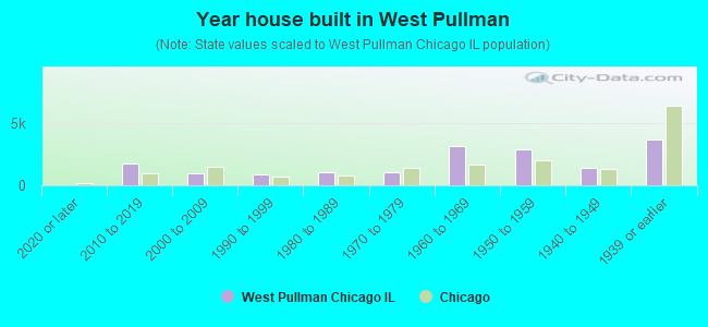
- Year house built in West Pullman
- 02020 or later
- 1,7592010 to 2019
- 9772000 to 2009
- 9001990 to 1999
- 1,0571980 to 1989
- 1,0571970 to 1979
- 3,1641960 to 1969
- 2,8661950 to 1959
- 1,4221940 to 1949
- 3,7071939 or earlier
City-data.com crime index for city in 2020 (higher means more crime):
| City: | 421.1 |
| U.S. average: | 219.5 |
Travel time to work (commute)
![Travel time to work (commute)]()
- 348Less than 5 minutes
- 2375 to 9 minutes
- 48810 to 14 minutes
- 83415 to 19 minutes
- 1,17820 to 24 minutes
- 46125 to 29 minutes
- 1,90530 to 34 minutes
- 15535 to 39 minutes
- 77140 to 44 minutes
- 1,54745 to 59 minutes
- 1,00460 to 89 minutes
- 83190 or more minutes

Means of transportation to work
![Means of transportation to work]()
- 60.3%6,108Drove a car alone
- 15.4%1,561Carpooled
- 9.7%978Bus
- 9.6%977Subway or elevated rail
- 4.9%493Long-distance train or commuter rail
- 14.0%1,414Light rail, streetcar or trolley
- 2.8%288Ferryboat
- 4.9%492Taxi
- 6.9%700Walked
- 11.6%1,176Other means
- 11.2%1,139Worked at home

Time leaving home to go to work
![Time leaving home to go to work]()
- 1,18912:00 a.m. to 4:59 a.m.
- 6005:00 a.m. to 5:29 a.m.
- 5795:30 a.m. to 5:59 a.m.
- 1,0726:00 a.m. to 6:29 a.m.
- 4536:30 a.m. to 6:59 a.m.
- 1,0907:00 a.m. to 7:29 a.m.
- 9207:30 a.m. to 7:59 a.m.
- 6958:00 a.m. to 8:29 a.m.
- 5648:30 a.m. to 8:59 a.m.
- 1,0849:00 a.m. to 9:59 a.m.
- 27710:00 a.m. to 10:59 a.m.
- 13911:00 a.m. to 11:59 a.m.
- 37312:00 p.m. to 3:59 p.m.
- 7134:00 p.m. to 11:59 p.m.

Occupations of males:
- Percentage of males in management occupations (except farmers):
Here: 5.3% city: 12.0%
- Percentage of males in business and financial operations occupations:
Here: 3.1% city: 7.9%
- Percentage of males in computer and mathematical occupations:
Here: 1.0% city: 6.3%
- Percentage of males in education, training, and library occupations:
Here: 2.0% city: 4.2%
- Percentage of males in healthcare practitioners and technical occupations:
Here: 1.3% city: 3.1%
- Percentage of males in service occupations:
Here: 23.4% city: 15.8%
- Percentage of males in sales and office occupations:
Here: 12.0% city: 14.5%
- Percentage of males in construction, extraction, and maintenance occupations:
Here: 8.3% city: 5.6%
- Percentage of males in production occupations:
Here: 12.9% city: 5.6%
- Percentage of males in transportation occupations:
Here: 11.1% city: 6.5%
- Percentage of males in material moving occupations:
Here: 11.2% city: 5.4%
Occupations of females:
- Percentage of females in management occupations (except farmers):
Here: 8.9% city: 11.1%
- Percentage of females in business and financial operations occupations:
Here: 5.5% city: 9.2%
- Percentage of females in community and social services occupations:
Here: 1.2% city: 3.0%
- Percentage of females in education, training, and library occupations:
Here: 5.4% city: 8.8%
- Percentage of females in healthcare practitioners and technical occupations:
Here: 4.7% city: 8.5%
- Percentage of females in service occupations:
Here: 29.0% city: 19.6%
- Percentage of females in sales and office occupations:
Here: 34.4% city: 23.3%
- Percentage of females in production occupations:
Here: 2.5% city: 3.0%
- Percentage of females in transportation occupations:
Here: 1.9% city: 1.5%
- Percentage of females in material moving occupations:
Here: 5.5% city: 1.9%
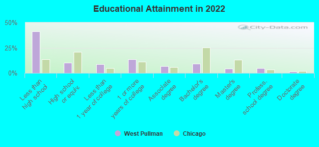
Education in this neighborhood (subdivision or community):
- Percentage of people 3 years and older in K-12 schools:
West Pullman: 36.7% Chicago: 14.6%
- Percentage of people 3 years and older in undergraduate colleges:
West Pullman: 6.4% Chicago: 5.1%
- Percentage of people 3 years and older in grad. or professional schools:
West Pullman: 2.6% Chicago: 2.6%
- Percentage of students K-12 enrolled in private schools:
West Pullman: 55.2% Chicago: 15.6%
Percentage of population below poverty level:
| West Pullman: | 21.4% |
| Chicago: | 17.2% |
Percentage of married-couple families with both working:
| West Pullman: | 103.8% |
| Chicago: | 69.2% |
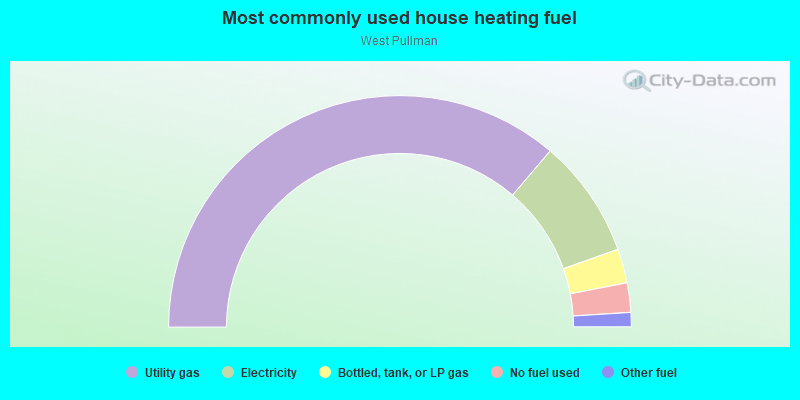
- 72.5%Utility gas
- 16.6%Electricity
- 4.8%Bottled, tank, or LP gas
- 4.1%No fuel used
- 2.0%Other fuel
Highways in this neighborhood:
S Halsted St (State Rte 1)
Length: 1.27 miles
Direction: N-S
Address range: 11544 to 12999
Direction: N-S
Address range: 11544 to 12999
Roads and streets:
W 122nd St
Length: 2.65 miles
Directions: E-W, SW-NE
Address range: 1 to 1599
Directions: E-W, SW-NE
Address range: 1 to 1599
W 119th St
Length: 2.59 miles
Direction: E-W
Address range: 1 to 1532
Direction: E-W
Address range: 1 to 1532
W 120th St
Length: 2.59 miles
Direction: E-W
Address range: 1 to 1533
Direction: E-W
Address range: 1 to 1533
W 123rd St
Length: 2.50 miles
Direction: E-W
Address range: 1 to 1599
Direction: E-W
Address range: 1 to 1599
W 116th St
Length: 2.47 miles
Directions: E-W, SW-NE
Address range: 1 to 1565
Directions: E-W, SW-NE
Address range: 1 to 1565
W 117th St
Length: 2.38 miles
Direction: E-W
Address range: 100 to 1565
Direction: E-W
Address range: 100 to 1565
W 118th St
Length: 2.33 miles
Direction: E-W
Address range: 1 to 1565
Direction: E-W
Address range: 1 to 1565
S Parnell Ave
Length: 1.85 miles
Directions: N-S, SE-NW
Address range: 11526 to 12999
Directions: N-S, SE-NW
Address range: 11526 to 12999
S Lowe Ave
Length: 1.83 miles
Directions: N-S, SE-NW
Address range: 11540 to 12999
Directions: N-S, SE-NW
Address range: 11540 to 12999
S Union Ave
Length: 1.81 miles
Direction: N-S
Address range: 11550 to 12999
Direction: N-S
Address range: 11550 to 12999
S Wallace St
Length: 1.77 miles
Directions: N-S, SE-NW
Address range: 11513 to 12999
Directions: N-S, SE-NW
Address range: 11513 to 12999
S Indiana Ave
Length: 1.70 miles
Directions: N-S, SE-NW, SW-NE
Address range: 11524 to 12999
Directions: N-S, SE-NW, SW-NE
Address range: 11524 to 12999
W 127th St
Length: 1.69 miles
Directions: E-W, SW-NE
Address range: 1 to 765
Directions: E-W, SW-NE
Address range: 1 to 765
S Wentworth Ave
Length: 1.57 miles
Direction: N-S
Address range: 11515 to 12799
Direction: N-S
Address range: 11515 to 12799
S Eggleston Ave
Length: 1.52 miles
Directions: N-S, SE-NW
Address range: 11528 to 12999
Directions: N-S, SE-NW
Address range: 11528 to 12999
S Princeton Ave
Length: 1.48 miles
Direction: N-S
Address range: 11526 to 12699
Direction: N-S
Address range: 11526 to 12699
S State St
Length: 1.48 miles
Direction: N-S
Address range: 11515 to 12699
Direction: N-S
Address range: 11515 to 12699
S Yale Ave
Length: 1.48 miles
Direction: N-S
Address range: 11526 to 12699
Direction: N-S
Address range: 11526 to 12699
S Emerald Ave
Length: 1.47 miles
Directions: N-S, SE-NW
Address range: 11800 to 12999
Directions: N-S, SE-NW
Address range: 11800 to 12999
S Michigan Ave
Length: 1.41 miles
Directions: E-W, N-S
Address range: 11536 to 12699
Directions: E-W, N-S
Address range: 11536 to 12699
S Normal Ave
Length: 1.39 miles
Direction: N-S
Address range: 11528 to 12999
Direction: N-S
Address range: 11528 to 12999
S Harvard Ave
Length: 1.35 miles
Direction: N-S
Address range: 11526 to 12699
Direction: N-S
Address range: 11526 to 12699
S Stewart Ave
Length: 1.35 miles
Direction: N-S
Address range: 11526 to 12699
Direction: N-S
Address range: 11526 to 12699
W 124th St
Length: 1.29 miles
Directions: E-W, SW-NE
Address range: 1 to 763
Directions: E-W, SW-NE
Address range: 1 to 763
S la Salle St
Length: 1.27 miles
Direction: N-S
Address range: 11516 to 12599
Direction: N-S
Address range: 11516 to 12599
S Perry Ave
Length: 1.27 miles
Directions: N-S, SE-NW
Address range: 11510 to 12636
Directions: N-S, SE-NW
Address range: 11510 to 12636
W 125th St
Length: 1.25 miles
Directions: E-W, SE-NW
Address range: 1 to 765
Directions: E-W, SE-NW
Address range: 1 to 765
S Peoria St
Length: 1.21 miles
Directions: N-S, SE-NW
Address range: 11525 to 12998
Directions: N-S, SE-NW
Address range: 11525 to 12998
S Lafayette Ave
Length: 1.09 miles
Direction: N-S
Address range: 11551 to 12399
Direction: N-S
Address range: 11551 to 12399
S Loomis St
Length: 0.94 miles
Directions: N-S, SW-NE
Address range: 11526 to 12299
Directions: N-S, SW-NE
Address range: 11526 to 12299
W 129th Pl
Length: 0.93 miles
Direction: E-W
Address range: 400 to 998
Direction: E-W
Address range: 400 to 998
S Morgan St
Length: 0.92 miles
Direction: N-S
Address range: 11517 to 12999
Direction: N-S
Address range: 11517 to 12999
W 126th St
Length: 0.90 miles
Direction: E-W
Address range: 200 to 765
Direction: E-W
Address range: 200 to 765
S Bishop St
Length: 0.86 miles
Directions: N-S, SE-NW, SW-NE
Address range: 11500 to 12251
Directions: N-S, SE-NW, SW-NE
Address range: 11500 to 12251
S Laflin St
Length: 0.79 miles
Direction: N-S
Address range: 11500 to 12299
Direction: N-S
Address range: 11500 to 12299
S Sangamon St
Length: 0.76 miles
Directions: E-W, N-S, SE-NW, SW-NE
Address range: 11530 to 12999
Directions: E-W, N-S, SE-NW, SW-NE
Address range: 11530 to 12999
S Justine St
Length: 0.75 miles
Direction: N-S
Address range: 11500 to 12199
Direction: N-S
Address range: 11500 to 12199
S Racine Ave
Length: 0.75 miles
Direction: N-S
Address range: 11527 to 12299
Direction: N-S
Address range: 11527 to 12299
S Green St
Length: 0.73 miles
Directions: N-S, SE-NW
Address range: 11600 to 12999
Directions: N-S, SE-NW
Address range: 11600 to 12999
W 128th Pl
Length: 0.73 miles
Direction: E-W
Address range: 400 to 899
Direction: E-W
Address range: 400 to 899
W Vermont Ave
Length: 0.67 miles
Direction: E-W
Address range: 600 to 999
Direction: E-W
Address range: 600 to 999
E 116th St
Length: 0.67 miles
Direction: E-W
Address range: 1 to 399
Direction: E-W
Address range: 1 to 399
S Prairie Ave
Length: 0.64 miles
Directions: N-S, SE-NW
Address range: 11524 to 12099
Directions: N-S, SE-NW
Address range: 11524 to 12099
W 121st St
Length: 0.62 miles
Direction: E-W
Address range: 1 to 1565
Direction: E-W
Address range: 1 to 1565
E 119th St
Length: 0.59 miles
Direction: E-W
Address range: 1 to 399
Direction: E-W
Address range: 1 to 399
S Elizabeth St
Length: 0.59 miles
Direction: N-S
Address range: 11526 to 12299
Direction: N-S
Address range: 11526 to 12299
S Throop St
Length: 0.58 miles
Direction: N-S
Address range: 11524 to 12299
Direction: N-S
Address range: 11524 to 12299
E Kensington Ave
Length: 0.57 miles
Direction: E-W
Address range: 100 to 443
Direction: E-W
Address range: 100 to 443
E 117th St
Length: 0.56 miles
Direction: E-W
Address range: 1 to 399
Direction: E-W
Address range: 1 to 399
E 120th St
Length: 0.54 miles
Direction: E-W
Address range: 1 to 399
Direction: E-W
Address range: 1 to 399
E 120th Pl
Length: 0.53 miles
Direction: E-W
Address range: 1 to 399
Direction: E-W
Address range: 1 to 399
E 121st St (Illinois Central RR)
Length: 0.52 miles
Direction: E-W
Address range: 1 to 399
Direction: E-W
Address range: 1 to 399
E 121st Pl
Length: 0.51 miles
Direction: E-W
Address range: 1 to 299
Direction: E-W
Address range: 1 to 299
W 116th Pl
Length: 0.49 miles
Direction: E-W
Address range: 600 to 999
Direction: E-W
Address range: 600 to 999
E 118th St
Length: 0.46 miles
Direction: E-W
Address range: 1 to 399
Direction: E-W
Address range: 1 to 399
S Ada St
Length: 0.46 miles
Direction: N-S
Address range: 11524 to 12299
Direction: N-S
Address range: 11524 to 12299
S Carpenter St
Length: 0.45 miles
Directions: E-W, N-S, SE-NW, SW-NE
Address range: 11526 to 12299
Directions: E-W, N-S, SE-NW, SW-NE
Address range: 11526 to 12299
E 119th Pl
Length: 0.41 miles
Direction: E-W
Address range: 1 to 399
Direction: E-W
Address range: 1 to 399
S Front Ave
Length: 0.39 miles
Directions: E-W, N-S, SW-NE
Address range: 11549 to 12199
Directions: E-W, N-S, SW-NE
Address range: 11549 to 12199
W Brayton St
Length: 0.36 miles
Directions: E-W, SW-NE
Address range: 1 to 199
Directions: E-W, SW-NE
Address range: 1 to 199
S Aberdeen St
Length: 0.35 miles
Direction: N-S
Address range: 11526 to 12299
Direction: N-S
Address range: 11526 to 12299
E 123rd St (James A Rogers Dr)
Length: 0.35 miles
Direction: E-W
Address range: 1 to 199
Direction: E-W
Address range: 1 to 199
E 125th Pl
Length: 0.35 miles
Directions: E-W, N-S, SE-NW
Address range: 1 to 199
Directions: E-W, N-S, SE-NW
Address range: 1 to 199
S May St
Length: 0.34 miles
Direction: N-S
Address range: 11526 to 12299
Direction: N-S
Address range: 11526 to 12299
E 124th St
Length: 0.34 miles
Direction: E-W
Address range: 1 to 199
Direction: E-W
Address range: 1 to 199
S Edbrooke Ave
Length: 0.34 miles
Directions: N-S, SE-NW
Address range: 12000 to 12699
Directions: N-S, SE-NW
Address range: 12000 to 12699
E 122nd Pl
Length: 0.34 miles
Direction: E-W
Address range: 1 to 199
Direction: E-W
Address range: 1 to 199
W 126th Pl
Length: 0.34 miles
Direction: E-W
Address range: 1 to 559
Direction: E-W
Address range: 1 to 559
E 118th Pl
Length: 0.33 miles
Direction: E-W
Address range: 1 to 199
Direction: E-W
Address range: 1 to 199
E 122nd St
Length: 0.33 miles
Direction: E-W
Address range: 1 to 199
Direction: E-W
Address range: 1 to 199
W 117th Pl
Length: 0.33 miles
Direction: E-W
Address range: 600 to 799
Direction: E-W
Address range: 600 to 799
W 125th Pl
Length: 0.33 miles
Direction: E-W
Address range: 1 to 599
Direction: E-W
Address range: 1 to 599
E 127th St
Length: 0.32 miles
Directions: E-W, N-S, SE-NW
Address range: 1 to 199
Directions: E-W, N-S, SE-NW
Address range: 1 to 199
E 117th Pl
Length: 0.30 miles
Direction: E-W
Address range: 1 to 199
Direction: E-W
Address range: 1 to 199
E 124th Pl
Length: 0.29 miles
Direction: E-W
Address range: 1 to 199
Direction: E-W
Address range: 1 to 199
S Calumet Ave
Length: 0.26 miles
Direction: N-S
Address range: 11700 to 12099
Direction: N-S
Address range: 11700 to 12099
W 115th St
Length: 0.17 miles
Direction: E-W
Address range: 1420 to 1533
Direction: E-W
Address range: 1420 to 1533
S Wabash Ave
Length: 0.15 miles
Direction: N-S
Address range: 11500 to 12499
Direction: N-S
Address range: 11500 to 12499
E Brayton Ave (E Brayton St)
Length: 0.15 miles
Direction: E-W
Address range: 1 to 99
Direction: E-W
Address range: 1 to 99
E 126th St
Length: 0.15 miles
Direction: E-W
Address range: 1 to 99
Direction: E-W
Address range: 1 to 99
W 128th St
Length: 0.12 miles
Direction: E-W
Address range: 500 to 599
Direction: E-W
Address range: 500 to 599
S Ashland Ave
Length: 0.12 miles
Direction: N-S
Address range: 12201 to 12299
Direction: N-S
Address range: 12201 to 12299
126th Pl
Length: 0.11 miles
Direction: E-W
Direction: E-W
W 127th Pl
Length: 0.10 miles
Direction: E-W
Address range: 500 to 599
Direction: E-W
Address range: 500 to 599
W 115th Pl
Length: 0.09 miles
Direction: E-W
Address range: 924 to 999
Direction: E-W
Address range: 924 to 999
Racine Ave
Length: 0.09 miles
Direction: N-S
Direction: N-S
Indiana Ave
Length: 0.09 miles
Direction: N-S
Direction: N-S
W 118th Pl
Length: 0.08 miles
Direction: E-W
Address range: 730 to 799
Direction: E-W
Address range: 730 to 799
P E 126th Pl
Length: 0.05 miles
Direction: E-W
Address range: 131 to 158
Direction: E-W
Address range: 131 to 158
E 130th St
Length: 0.02 miles
Direction: E-W
Address range: 1 to 199
Direction: E-W
Address range: 1 to 199
Railroad features:
Illinois Central RR
Length: 8.63 miles
Directions: E-W, N-S, SE-NW, SW-NE
Directions: E-W, N-S, SE-NW, SW-NE
Csx RR & Norfolk Southern Rlwy (Penn Central RR)
Length: 4.47 miles
Directions: E-W, N-S, SE-NW, SW-NE
Directions: E-W, N-S, SE-NW, SW-NE
Csx RR & Norfolk Southern Rlwy
Length: 1.01 miles
Directions: E-W, SE-NW
Directions: E-W, SE-NW
Chicago and Western Indiana RR
Length: 0.82 miles
Direction: SE-NW
Direction: SE-NW