Downtown neighborhood in Jacksonville, Florida (FL), 32207, 32202, 32204 detailed profile
Settings
X


Business Search - 14 Million verified businesses
Area: 3.307 square miles
Population: 17,221
Population density:
| Downtown: | 5,208 people per square mile |
| Jacksonville: | 1,282 people per square mile |

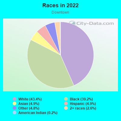
- 8,02443.4%White
- 7,25339.2%Black
- 9104.9%Asian
- 9044.9%Hispanic or Latino
- 8854.8%Some other race
- 4782.6%Two or more races
- 360.2%American Indian
Distribution of median household income
![Distribution of median household income]()
- 571Less than $10,000
- 1,791$10,000 to $19,999
- 235$20,000 to $29,999
- 927$30,000 to $39,999
- 563$40,000 to $49,999
- 945$50,000 to $59,999
- 219$60,000 to $74,999
- 968$75,000 to $99,999
- 174$100,000 to $124,999
- 194$125,000 to $149,999
- 461$150,000 to $199,999
- 492$200,000 or more

Distribution of owner-occupied house/condo value
![Distribution of owner-occupied house/condo value]()
- 545Less than $50,000
- 996$50,000 to $99,999
- 466$100,000 to $149,999
- 103$150,000 to $199,999
- 108$200,000 to $249,999
- 52$250,000 to $299,999
- 137$300,000 to $399,999
- 244$400,000 to $499,999
- 469$500,000 to $749,999
- 85$750,000 to $999,999
- 31$1,000,000 or more

Distribution of rent paid by renters
![Distribution of rent paid by renters]()
- 523Less than $100
- 167$100 to $199
- 1,168$200 to $299
- 1,376$300 to $399
- 363$400 to $499
- 1,640$500 to $599
- 1,332$600 to $699
- 341$700 to $799
- 355$800 to $899
- 84$900 to $999
- 453$1,000 to $1,249
- 443$1,250 to $1,499
- 292$1,500 to $1,999
- 2,089$2,000 or more

Median rent in 2022:
| Downtown: | $1,151 |
| Jacksonville: | $1,230 |
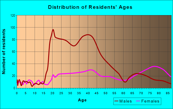
| Males: | 11,114 |
| Females: | 6,106 |
Males:
| This neighborhood: | 41.6 years |
| Whole city: | 35.4 years |
| This neighborhood: | 52.7 years |
| Whole city: | 37.7 years |
Average household size:
| Downtown: | 1.7 people |
| Jacksonville: | 2.4 people |
Percentage of family households:
| Downtown: | 11.5% |
| Jacksonville: | 45.3% |
| Here: | 16.2% |
| Jacksonville: | 41.0% |
Percentage of married-couple families with children (among all households):
| Downtown: | 55.3% |
| Jacksonville: | 23.7% |
Percentage of single-mother households (among all households):
| Downtown: | 26.4% |
| Jacksonville: | 13.9% |
Percentage of never married males 15 years old and over:
Percentage of never married females 15 years old and over:
| Downtown: | 36.0% |
| Jacksonville: | 18.4% |
Percentage of never married females 15 years old and over:
| Downtown: | 14.5% |
| city: | 17.3% |
Percentage of people that speak English not well or not at all:
| Downtown: | 1.7% |
| Jacksonville: | 3.0% |
Percentage of people born in this state:
Percentage of people born in another U.S. state:
Percentage of native residents but born outside the U.S.:
Percentage of foreign born residents:
| Here: | 48.2% |
| Jacksonville: | 47.1% |
Percentage of people born in another U.S. state:
| Downtown: | 42.3% |
| Jacksonville: | 37.3% |
Percentage of native residents but born outside the U.S.:
| Here: | 0.8% |
| city: | 3.0% |
Percentage of foreign born residents:
| Here: | 8.7% |
| Jacksonville: | 12.6% |
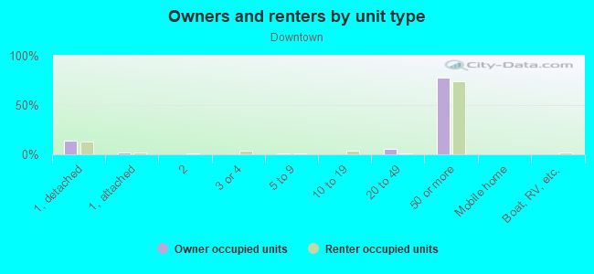
Owner-occupied
Renter-occupied

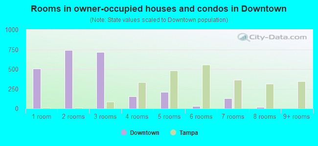
- Rooms in owner-occupied houses and condos in Downtown
- 281 room
- 122 rooms
- 1263 rooms
- 2024 rooms
- 3165 rooms
- 986 rooms
- 1517 rooms
- 558 rooms
- 1589+ rooms
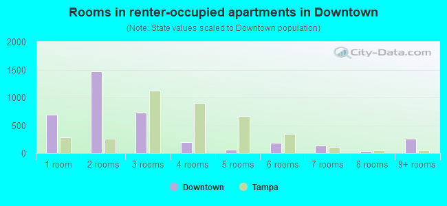
- Rooms in renter-occupied apartments in Downtown
- 5421 room
- 4312 rooms
- 2,0363 rooms
- 8154 rooms
- 5585 rooms
- 1836 rooms
- 627 rooms
- 118 rooms
- 679+ rooms
Owner-occupied
Renter-occupied
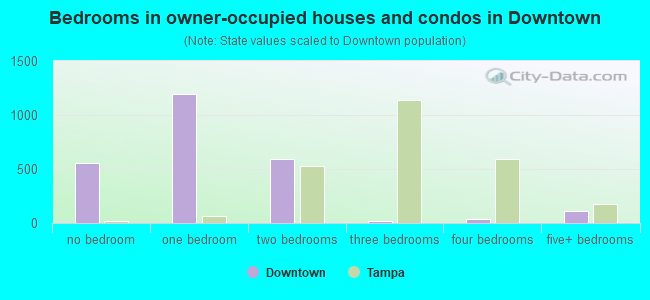
- Bedrooms in owner-occupied houses and condos in Downtown
- 28no bedroom
- 521 bedroom
- 4402 bedrooms
- 2413 bedrooms
- 1204 bedrooms
- 455+ bedrooms
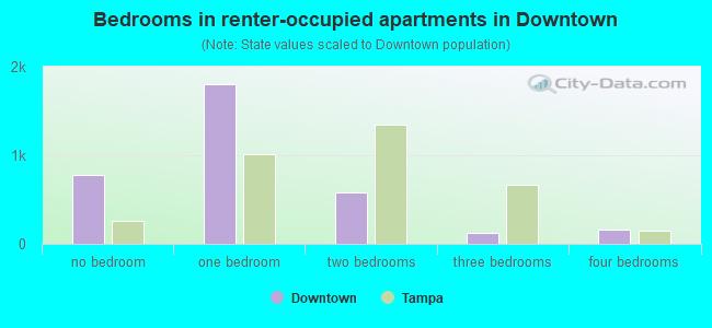
- Bedrooms in renter-occupied apartments in Downtown
- 630no bedroom
- 2,2521 bedroom
- 1,4252 bedrooms
- 2803 bedrooms
- 424 bedrooms
- 1665+ bedrooms
Average number of cars or other vehicles available in houses/condos:
Average number of cars or other vehicles available in apartments:
| This neighborhood: | 1.8 |
| Jacksonville: | 2.0 |
Average number of cars or other vehicles available in apartments:
| Here: | 0.7 |
| city: | 1.3 |
Percentage of units with a mortgage:
| Downtown: | 68.8% |
| Jacksonville: | 65.5% |
Average estimated value of detached houses in 2022 (4.7% of all units):
| Downtown: | $105,537 |
| Jacksonville: | $300,836 |
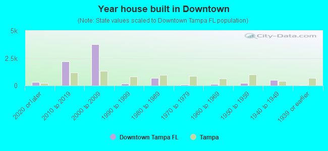
- Year house built in Downtown
- 1812020 or later
- 7652010 to 2019
- 2,2542000 to 2009
- 921990 to 1999
- 1971980 to 1989
- 1,6671970 to 1979
- 7151960 to 1969
- 3011950 to 1959
- 9311940 to 1949
- 7151939 or earlier
Travel time to work (commute)
![Travel time to work (commute)]()
- 110Less than 5 minutes
- 6655 to 9 minutes
- 73010 to 14 minutes
- 96115 to 19 minutes
- 66620 to 24 minutes
- 20825 to 29 minutes
- 57430 to 34 minutes
- 3335 to 39 minutes
- 5740 to 44 minutes
- 16045 to 59 minutes
- 8060 to 89 minutes
- 4790 or more minutes

Means of transportation to work
![Means of transportation to work]()
- 55.9%2,202Drove a car alone
- 8.9%349Carpooled
- 9.3%368Bus
- 2.8%110Subway or elevated rail
- 3.5%137Taxi
- 3.3%132Motorcycle
- 13.1%518Bicycle
- 9.9%390Walked
- 1.8%71Other means
- 20.3%802Worked at home

Time leaving home to go to work
![Time leaving home to go to work]()
- 8012:00 a.m. to 4:59 a.m.
- 785:00 a.m. to 5:29 a.m.
- 1045:30 a.m. to 5:59 a.m.
- 2846:00 a.m. to 6:29 a.m.
- 4736:30 a.m. to 6:59 a.m.
- 9277:00 a.m. to 7:29 a.m.
- 7127:30 a.m. to 7:59 a.m.
- 4718:00 a.m. to 8:29 a.m.
- 3588:30 a.m. to 8:59 a.m.
- 4029:00 a.m. to 9:59 a.m.
- 4910:00 a.m. to 10:59 a.m.
- 9711:00 a.m. to 11:59 a.m.
- 31112:00 p.m. to 3:59 p.m.
- 1714:00 p.m. to 11:59 p.m.

Occupations of males:
- Percentage of males in management occupations (except farmers):
Here: 9.1% city: 10.6%
- Percentage of males in business and financial operations occupations:
Here: 2.8% city: 5.9%
- Percentage of males in computer and mathematical occupations:
Here: 10.9% city: 5.4%
- Percentage of males in architecture and engineering occupations:
Here: 1.6% city: 2.2%
- Percentage of males in legal occupations:
Here: 5.1% city: 0.8%
- Percentage of males in arts, design, entertainment, sports, and media occupations:
Here: 3.2% city: 2.2%
- Percentage of males in healthcare practitioners and technical occupations:
Here: 9.3% city: 2.9%
- Percentage of males in service occupations:
Here: 8.2% city: 15.3%
- Percentage of males in sales and office occupations:
Here: 35.6% city: 17.3%
- Percentage of males in construction, extraction, and maintenance occupations:
Here: 4.3% city: 8.1%
- Percentage of males in production occupations:
Here: 3.3% city: 4.8%
- Percentage of males in transportation occupations:
Here: 9.5% city: 7.2%
- Percentage of males in material moving occupations:
Here: 3.5% city: 7.0%
Occupations of females:
- Percentage of females in management occupations (except farmers):
Here: 15.6% city: 9.4%
- Percentage of females in business and financial operations occupations:
Here: 8.1% city: 7.3%
- Percentage of females in computer and mathematical occupations:
Here: 1.7% city: 2.4%
- Percentage of females in life, physical, and social science occupations:
Here: 1.7% city: 0.6%
- Percentage of females in community and social services occupations:
Here: 4.2% city: 2.5%
- Percentage of females in legal occupations:
Here: 3.3% city: 1.2%
- Percentage of females in education, training, and library occupations:
Here: 6.0% city: 7.6%
- Percentage of females in healthcare practitioners and technical occupations:
Here: 25.7% city: 9.7%
- Percentage of females in service occupations:
Here: 15.3% city: 19.3%
- Percentage of females in sales and office occupations:
Here: 18.0% city: 30.1%
- Percentage of females in transportation occupations:
Here: 1.6% city: 1.3%
Percentage of people 16-64 in Armed Forces:
| Downtown: | 0.5% |
| Jacksonville: | 2.6% |
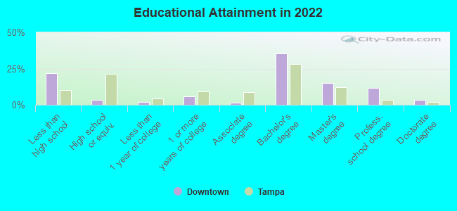
Education in this neighborhood (subdivision or community):
- Percentage of people 3 years and older in K-12 schools:
Downtown: 10.4% Jacksonville: 16.3%
- Percentage of people 3 years and older in undergraduate colleges:
Downtown: 4.1% Jacksonville: 4.6%
- Percentage of people 3 years and older in grad. or professional schools:
Downtown: 1.2% Jacksonville: 1.4%
- Percentage of students K-12 enrolled in private schools:
Downtown: 6.0% Jacksonville: 15.6%
Percentage of population below poverty level:
| Downtown: | 23.2% |
| Jacksonville: | 14.1% |
Median year renter moved in (as recorded in 2022):
| Downtown: | 2015 |
| Jacksonville: | 2020 |
Percentage of married-couple families with both working:
| Downtown: | 75.9% |
| Jacksonville: | 72.8% |
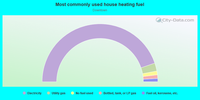
- 93.0%Electricity
- 4.0%Fuel oil, kerosene, etc.
- 1.2%Utility gas
- 1.1%No fuel used
- 0.7%Bottled, tank, or LP gas
Limited-access highways (interstate or state) in this neighborhood:
I- 95
Length: 3.42 miles
Directions: E-W, SW-NE
Directions: E-W, SW-NE
Highways in this neighborhood:
State Hwy 228 (Commodore Point Expy, Commodore Point Expy, Hart Xy, Hart Xy)
Length: 2.03 miles
Directions: E-W, SE-NW
Directions: E-W, SE-NW
Matthews Expy (US Hwy 23)
Length: 1.18 miles
Directions: E-W, SE-NW
Directions: E-W, SE-NW
E Adams St (State Hwy 228, E Adams St)
Length: 1.11 miles
Directions: E-W, N-S, SE-NW
Address range: 1 to 1255
Directions: E-W, N-S, SE-NW
Address range: 1 to 1255
W Beaver St (State Hwy 10, US Hwy 90)
Length: 1.03 miles
Direction: E-W
Address range: 1 to 999
Direction: E-W
Address range: 1 to 999
E Bay St (E Bay St)
Length: 1.03 miles
Directions: E-W, SE-NW
Address range: 100 to 999
Directions: E-W, SE-NW
Address range: 100 to 999
US Hwy 1 Alt
Length: 0.89 miles
Directions: N-S, SE-NW
Directions: N-S, SE-NW
State Hwy 228 (Broad St, State Hwy 228, US Hwy 17, Broad St)
Length: 0.78 miles
Directions: N-S, SW-NE
Address range: 1 to 899
Directions: N-S, SW-NE
Address range: 1 to 899
Riverside Ave (State Hwy 228, State Hwy 211, State Hwy 211, State Hwy 228, US Hwy 17, Riverside Ave)
Length: 0.75 miles
Direction: SW-NE
Address range: 1 to 599
Direction: SW-NE
Address range: 1 to 599
Alltel Stadium Pl (Commodore Point Expy, State Hwy 228, Hart Xy, State Hwy 228, Commodore Point Expy, Alltel Stadium Pl, Hart Xy)
Length: 0.64 miles
Direction: E-W
Direction: E-W
Acosta Brg (Acosta Brg, State Hwy 13, State Hwy 13)
Length: 0.57 miles
Directions: N-S, SE-NW
Directions: N-S, SE-NW
State Hwy 115 (N Pearl St)
Length: 0.48 miles
Direction: N-S
Address range: 1 to 899
Direction: N-S
Address range: 1 to 899
State Hwy 13 (State Hwy 13, Hendricks Ave, Hendricks Ave)
Length: 0.40 miles
Directions: N-S, SE-NW
Address range: 700 to 1399
Directions: N-S, SE-NW
Address range: 700 to 1399
US Hwy 17 (N Main St, US Hwy 1, N Main St, US Hwy 17, US Hwy 90, State Hwy 5, US Hwy 90)
Length: 0.38 miles
Direction: N-S
Address range: 1 to 699
Direction: N-S
Address range: 1 to 699
E State St (US Hwy 23, E State St)
Length: 0.36 miles
Direction: E-W
Address range: 1 to 399
Direction: E-W
Address range: 1 to 399
State Hwy 5 (Kings Ave, State Hwy 5, US Hwy 1, Kings Ave, US Hwy 1)
Length: 0.29 miles
Direction: N-S
Address range: 1000 to 1399
Direction: N-S
Address range: 1000 to 1399
Riverplace Blvd (State Hwy 13, Riverplace Blvd, Gulf Life Dr, Gulf Life Dr, State Hwy 13)
Length: 0.28 miles
Directions: E-W, SE-NW
Address range: 1100 to 1499
Directions: E-W, SE-NW
Address range: 1100 to 1499
Museum Cir (Gulf Life Dr, State Hwy 13, State Hwy 13, Museum Cir, Gulf Life Dr)
Length: 0.18 miles
Direction: E-W
Address range: 831 to 1099
Direction: E-W
Address range: 831 to 1099
US Hwy 17 (State Hwy 5, US Hwy 17, Main St N, N Main St, N Main St, US Hwy 1, Main St N)
Length: 0.11 miles
Direction: N-S
Address range: 700 to 899
Direction: N-S
Address range: 700 to 899
E Bay St (Bay St E, State Hwy 228, State Hwy 228, Bay St E, E Bay St)
Length: 0.08 miles
Directions: E-W, SE-NW
Address range: 1 to 99
Directions: E-W, SE-NW
Address range: 1 to 99
Old Kings Rd (Old Kings Rd, US Hwy 23)
Length: 0.06 miles
Direction: SE-NW
Address range: 800 to 899
Direction: SE-NW
Address range: 800 to 899
Hill St (US Hwy 90 Alt, State Hwy 115, Mathews Brg, Hill St, Mathews Brg)
Length: 0.04 miles
Direction: E-W
Direction: E-W
Roads and streets:
S Main St (S Main St)
Length: 1.91 miles
Directions: E-W, N-S, SE-NW, SW-NE
Address range: 1 to 1099
Directions: E-W, N-S, SE-NW, SW-NE
Address range: 1 to 1099
E Duval St (E Duval St)
Length: 1.63 miles
Direction: E-W
Address range: 1 to 1673
Direction: E-W
Address range: 1 to 1673
W Bay St (W Bay St)
Length: 1.27 miles
Direction: E-W
Address range: 1 to 1225
Direction: E-W
Address range: 1 to 1225
W Forsyth St (W Forsyth St)
Length: 1.25 miles
Direction: E-W
Address range: 1 to 1265
Direction: E-W
Address range: 1 to 1265
W Monroe St (Monroe St W, Monroe St W, W Monroe St)
Length: 1.17 miles
Directions: E-W, SW-NE
Address range: 1 to 1199
Directions: E-W, SW-NE
Address range: 1 to 1199
E Church St (E Church St)
Length: 1.14 miles
Direction: E-W
Address range: 1 to 1619
Direction: E-W
Address range: 1 to 1619
W Adams St (W Adams St)
Length: 1.11 miles
Direction: E-W
Address range: 1 to 1199
Direction: E-W
Address range: 1 to 1199
E Beaver St (E Beaver St)
Length: 1.07 miles
Direction: E-W
Address range: 1 to 1672
Direction: E-W
Address range: 1 to 1672
W Duval St (W Duval St)
Length: 1.01 miles
Direction: E-W
Address range: 1 to 1099
Direction: E-W
Address range: 1 to 1099
W Church St (W Church St, Church St W, Church St W)
Length: 0.98 miles
Direction: E-W
Address range: 1 to 1098
Direction: E-W
Address range: 1 to 1098
Acosta Xy (Acosta Xy)
Length: 0.97 miles
Directions: E-W, SE-NW
Directions: E-W, SE-NW
W Union St (W Union St)
Length: 0.94 miles
Directions: E-W, SE-NW
Address range: 1 to 999
Directions: E-W, SE-NW
Address range: 1 to 999
E Monroe St (E Monroe St)
Length: 0.92 miles
Direction: E-W
Address range: 1 to 1199
Direction: E-W
Address range: 1 to 1199
Park St (Park St)
Length: 0.91 miles
Direction: SW-NE
Address range: 1 to 709
Direction: SW-NE
Address range: 1 to 709
Gator Bowl Blvd (Gator Bowl Blvd)
Length: 0.91 miles
Directions: E-W, N-S, SE-NW, SW-NE
Address range: 1 to 1410
Directions: E-W, N-S, SE-NW, SW-NE
Address range: 1 to 1410
E Ashley St (E Ashley St)
Length: 0.87 miles
Direction: E-W
Address range: 1 to 1099
Direction: E-W
Address range: 1 to 1099
W State St (W State St)
Length: 0.87 miles
Directions: E-W, N-S, SE-NW
Address range: 1 to 1099
Directions: E-W, N-S, SE-NW
Address range: 1 to 1099
W Ashley St (W Ashley St)
Length: 0.82 miles
Direction: E-W
Address range: 1 to 1099
Direction: E-W
Address range: 1 to 1099
Oak St (Oak St)
Length: 0.81 miles
Directions: N-S, SW-NE
Address range: 1 to 699
Directions: N-S, SW-NE
Address range: 1 to 699
Chelsea St (Chelsea St)
Length: 0.78 miles
Directions: E-W, SW-NE
Address range: 1 to 699
Directions: E-W, SW-NE
Address range: 1 to 699
Water St (Water St)
Length: 0.78 miles
Direction: E-W
Address range: 200 to 1099
Direction: E-W
Address range: 200 to 1099
San Marco Blvd (San Marco Blvd)
Length: 0.72 miles
Directions: E-W, N-S, SE-NW
Address range: 600 to 1599
Directions: E-W, N-S, SE-NW
Address range: 600 to 1599
Miami Rd (Miami Rd, Prudential Dr, Prudential Dr)
Length: 0.68 miles
Direction: E-W
Address range: 800 to 1799
Direction: E-W
Address range: 800 to 1799
Houston St (Houston St)
Length: 0.68 miles
Direction: E-W
Address range: 500 to 1199
Direction: E-W
Address range: 500 to 1199
Nira St (Nira St)
Length: 0.67 miles
Direction: E-W
Address range: 800 to 1599
Direction: E-W
Address range: 800 to 1599
Magnolia St (Magnolia St)
Length: 0.60 miles
Direction: SW-NE
Address range: 1 to 499
Direction: SW-NE
Address range: 1 to 499
E Forsyth St (E Forsyth St)
Length: 0.59 miles
Direction: E-W
Address range: 1 to 1099
Direction: E-W
Address range: 1 to 1099
May St (May St)
Length: 0.58 miles
Directions: N-S, SW-NE
Address range: 62 to 699
Directions: N-S, SW-NE
Address range: 62 to 699
Jefferson St (Jefferson St)
Length: 0.58 miles
Direction: N-S
Address range: 1 to 899
Direction: N-S
Address range: 1 to 899
Ocean St (Ocean St)
Length: 0.57 miles
Directions: N-S, SW-NE
Address range: 1 to 899
Directions: N-S, SW-NE
Address range: 1 to 899
E Union St (E Union St)
Length: 0.57 miles
Directions: E-W, SE-NW, SW-NE
Address range: 1 to 499
Directions: E-W, SE-NW, SW-NE
Address range: 1 to 499
Lee St (Lee St)
Length: 0.57 miles
Directions: N-S, SW-NE
Address range: 1 to 899
Directions: N-S, SW-NE
Address range: 1 to 899
Laura St N (N Laura St, N Laura St, Laura St N)
Length: 0.56 miles
Direction: N-S
Address range: 1 to 899
Direction: N-S
Address range: 1 to 899
N Davis St (N Davis St)
Length: 0.55 miles
Direction: N-S
Address range: 2 to 919
Direction: N-S
Address range: 2 to 919
Forest St (Forest St)
Length: 0.55 miles
Directions: E-W, SE-NW
Address range: 500 to 1289
Directions: E-W, SE-NW
Address range: 500 to 1289
Rosselle St (Rosselle St)
Length: 0.55 miles
Direction: E-W
Address range: 500 to 1199
Direction: E-W
Address range: 500 to 1199
Newnan St (Newnan St)
Length: 0.54 miles
Direction: N-S
Address range: 1 to 899
Direction: N-S
Address range: 1 to 899
Palm Ave (Palm Ave)
Length: 0.52 miles
Direction: N-S
Address range: 1000 to 1599
Direction: N-S
Address range: 1000 to 1599
Dora St (Dora St)
Length: 0.51 miles
Direction: SE-NW
Address range: 500 to 1399
Direction: SE-NW
Address range: 500 to 1399
Jackson St (Jackson St)
Length: 0.50 miles
Directions: E-W, SE-NW
Address range: 500 to 1399
Directions: E-W, SE-NW
Address range: 500 to 1399
Flagler Ave (Flagler Ave)
Length: 0.49 miles
Directions: N-S, SE-NW
Address range: 700 to 1499
Directions: N-S, SE-NW
Address range: 700 to 1499
Gary St (Gary St)
Length: 0.49 miles
Direction: E-W
Address range: 850 to 1599
Direction: E-W
Address range: 850 to 1599
N Liberty St (N Liberty St)
Length: 0.49 miles
Direction: N-S
Address range: 1 to 899
Direction: N-S
Address range: 1 to 899
Hogan St (Hogan St)
Length: 0.48 miles
Direction: N-S
Address range: 1 to 899
Direction: N-S
Address range: 1 to 899
Julia St (Julia St)
Length: 0.48 miles
Direction: N-S
Address range: 1 to 899
Direction: N-S
Address range: 1 to 899
Cedar St (Cedar St)
Length: 0.46 miles
Direction: E-W
Address range: 801 to 1299
Direction: E-W
Address range: 801 to 1299
Edison Ave (Edison Ave)
Length: 0.43 miles
Direction: E-W
Address range: 600 to 1199
Direction: E-W
Address range: 600 to 1199
S Myrtle Ave (S Myrtle Ave)
Length: 0.42 miles
Directions: N-S, SW-NE
Address range: 36 to 399
Directions: N-S, SW-NE
Address range: 36 to 399
Spruce St (Spruce St)
Length: 0.41 miles
Direction: SW-NE
Address range: 100 to 499
Direction: SW-NE
Address range: 100 to 499
A Philip Randolph Blvd (Florida Ave, Florida Ave, A Philip Randolph Blvd)
Length: 0.38 miles
Direction: N-S
Address range: 50 to 638
Direction: N-S
Address range: 50 to 638
Victoria St (Victoria St)
Length: 0.37 miles
Directions: E-W, N-S, SW-NE
Address range: 200 to 583
Directions: E-W, N-S, SW-NE
Address range: 200 to 583
Stonewall St (Stonewall St)
Length: 0.36 miles
Direction: SE-NW
Address range: 600 to 1199
Direction: SE-NW
Address range: 600 to 1199
Lafayette St (Lafayette St)
Length: 0.36 miles
Direction: N-S
Address range: 1 to 631
Direction: N-S
Address range: 1 to 631
Parker St (Parker St)
Length: 0.35 miles
Directions: N-S, SE-NW
Address range: 100 to 399
Directions: N-S, SE-NW
Address range: 100 to 399
Dellwood Ave (Dellwood Ave)
Length: 0.35 miles
Directions: N-S, SW-NE
Address range: 100 to 599
Directions: N-S, SW-NE
Address range: 100 to 599
Beaver St (Beaver St)
Length: 0.34 miles
Directions: E-W, N-S, SE-NW, SW-NE
Directions: E-W, N-S, SE-NW, SW-NE
Larue Ave (Larue Ave)
Length: 0.34 miles
Direction: N-S
Address range: 1200 to 1599
Direction: N-S
Address range: 1200 to 1599
S Acosta Bg (S Acosta Bg)
Length: 0.33 miles
Direction: SE-NW
Direction: SE-NW
Mary St (Mary St)
Length: 0.33 miles
Directions: E-W, SE-NW
Address range: 800 to 1299
Directions: E-W, SE-NW
Address range: 800 to 1299
N Washington St (N Washington St)
Length: 0.32 miles
Direction: N-S
Address range: 50 to 637
Direction: N-S
Address range: 50 to 637
Acstbexit Sanmar Xy (Acstbexit Sanmar Xy)
Length: 0.32 miles
Direction: SE-NW
Direction: SE-NW
N Georgia St (N Georgia St)
Length: 0.31 miles
Directions: N-S, SW-NE
Address range: 1 to 533
Directions: N-S, SW-NE
Address range: 1 to 533
Elm St (Elm St)
Length: 0.31 miles
Directions: E-W, SW-NE
Address range: 200 to 1599
Directions: E-W, SW-NE
Address range: 200 to 1599
Louisa St (Louisa St)
Length: 0.30 miles
Direction: E-W
Address range: 1300 to 1699
Direction: E-W
Address range: 1300 to 1699
Johnson St (Johnson St)
Length: 0.30 miles
Direction: N-S
Address range: 1 to 599
Direction: N-S
Address range: 1 to 599
Price St (Price St)
Length: 0.29 miles
Directions: E-W, N-S, SE-NW
Address range: 800 to 1399
Directions: E-W, N-S, SE-NW
Address range: 800 to 1399
N Clay St (N Clay St)
Length: 0.29 miles
Direction: N-S
Address range: 1 to 499
Direction: N-S
Address range: 1 to 499
Madison St (Madison St)
Length: 0.28 miles
Direction: N-S
Address range: 100 to 899
Direction: N-S
Address range: 100 to 899
Palmetto St (Palmetto St)
Length: 0.28 miles
Direction: N-S
Address range: 200 to 679
Direction: N-S
Address range: 200 to 679
Van Buren St (Van Buren St)
Length: 0.27 miles
Direction: N-S
Address range: 200 to 599
Direction: N-S
Address range: 200 to 599
Market St (Market St)
Length: 0.27 miles
Direction: N-S
Address range: 1 to 499
Direction: N-S
Address range: 1 to 499
Spearing St (Spearing St)
Length: 0.26 miles
Direction: N-S
Address range: 200 to 699
Direction: N-S
Address range: 200 to 699
N Catherine St (N Catherine St)
Length: 0.24 miles
Directions: N-S, SW-NE
Address range: 1 to 499
Directions: N-S, SW-NE
Address range: 1 to 499
Lasalle St (Lasalle St)
Length: 0.24 miles
Direction: E-W
Address range: 800 to 1099
Direction: E-W
Address range: 800 to 1099
Prudential Dr (Prudential Dr)
Length: 0.23 miles
Direction: E-W
Address range: 1511 to 1660
Direction: E-W
Address range: 1511 to 1660
Belmonte Ave (Belmonte Ave)
Length: 0.22 miles
Directions: N-S, SE-NW
Address range: 1200 to 1499
Directions: N-S, SE-NW
Address range: 1200 to 1499
Clay St (Clay St)
Length: 0.22 miles
Direction: N-S
Address range: 500 to 899
Direction: N-S
Address range: 500 to 899
Gilmore St (Gilmore St)
Length: 0.21 miles
Direction: E-W
Address range: 700 to 999
Direction: E-W
Address range: 700 to 999
N Market St (N Market St)
Length: 0.21 miles
Direction: N-S
Address range: 500 to 899
Direction: N-S
Address range: 500 to 899
Stuart St (Stuart St)
Length: 0.21 miles
Direction: N-S
Address range: 1 to 399
Direction: N-S
Address range: 1 to 399
Phillips St (Phillips St)
Length: 0.20 miles
Direction: E-W
Address range: 800 to 999
Direction: E-W
Address range: 800 to 999
College St (College St)
Length: 0.20 miles
Direction: SW-NE
Address range: 400 to 599
Direction: SW-NE
Address range: 400 to 599
Coastline Dr (Coastline Dr)
Length: 0.19 miles
Direction: E-W
Address range: 391 to 399
Direction: E-W
Address range: 391 to 399
Leila St (Leila St)
Length: 0.19 miles
Direction: SE-NW
Address range: 600 to 999
Direction: SE-NW
Address range: 600 to 999
N I95Exit Acstx Ramp (N I95Exit Acstx Ramp)
Length: 0.17 miles
Direction: E-W
Direction: E-W
S Pearl St (S Pearl St)
Length: 0.16 miles
Direction: N-S
Address range: 1 to 299
Direction: N-S
Address range: 1 to 299
Franklin St (Franklin St)
Length: 0.16 miles
Direction: N-S
Address range: 400 to 599
Direction: N-S
Address range: 400 to 599
S Hogan St (S Hogan St)
Length: 0.15 miles
Direction: N-S
Address range: 1 to 398
Direction: N-S
Address range: 1 to 398
Lisbon St (Lisbon St)
Length: 0.15 miles
Direction: E-W
Address range: 1100 to 1299
Direction: E-W
Address range: 1100 to 1299
S Liberty St (S Liberty St)
Length: 0.15 miles
Direction: N-S
Address range: 1 to 199
Direction: N-S
Address range: 1 to 199
S Market St (S Market St)
Length: 0.15 miles
Direction: N-S
Address range: 1 to 199
Direction: N-S
Address range: 1 to 199
Lebaron Ave (Lebaron Ave)
Length: 0.14 miles
Directions: N-S, SE-NW
Address range: 1301 to 1599
Directions: N-S, SE-NW
Address range: 1301 to 1599
Naldo Ave (Naldo Ave)
Length: 0.13 miles
Direction: N-S
Address range: 1200 to 1444
Direction: N-S
Address range: 1200 to 1444
Kipp Ave (Kipp Ave)
Length: 0.13 miles
Direction: N-S
Address range: 1000 to 1099
Direction: N-S
Address range: 1000 to 1099
Onyx St (Onyx St)
Length: 0.13 miles
Directions: N-S, SE-NW
Directions: N-S, SE-NW
E Independent Dr (E Independent Dr)
Length: 0.13 miles
Direction: E-W
Address range: 1 to 199
Direction: E-W
Address range: 1 to 199
Home St (Home St)
Length: 0.12 miles
Direction: E-W
Address range: 1400 to 1499
Direction: E-W
Address range: 1400 to 1499
Festival Park Ave (Festival Park Ave)
Length: 0.12 miles
Direction: N-S
Direction: N-S
Harper St (Harper St)
Length: 0.12 miles
Direction: E-W
Address range: 1400 to 1598
Direction: E-W
Address range: 1400 to 1598
Dante Pl (Dante Pl)
Length: 0.11 miles
Direction: E-W
Address range: 900 to 999
Direction: E-W
Address range: 900 to 999
Cordova Pl (Cordova Pl)
Length: 0.11 miles
Direction: E-W
Address range: 900 to 999
Direction: E-W
Address range: 900 to 999
Mc Coys Creek Blvd (Mc Coys Creek Blvd)
Length: 0.11 miles
Direction: E-W
Address range: 1500 to 1579
Direction: E-W
Address range: 1500 to 1579
Marsh St (Marsh St)
Length: 0.11 miles
Direction: N-S
Address range: 1 to 199
Direction: N-S
Address range: 1 to 199
Hanover St (Hanover St)
Length: 0.10 miles
Directions: N-S, SE-NW
Address range: 1 to 199
Directions: N-S, SE-NW
Address range: 1 to 199
Independent Dr (Independent Dr)
Length: 0.09 miles
Directions: E-W, SW-NE
Address range: 100 to 199
Directions: E-W, SW-NE
Address range: 100 to 199
E Coastline Dr (E Coastline Dr)
Length: 0.09 miles
Direction: E-W
Address range: 100 to 299
Direction: E-W
Address range: 100 to 299
Dorel St (Dorel St)
Length: 0.08 miles
Direction: E-W
Address range: 1200 to 1299
Direction: E-W
Address range: 1200 to 1299
Elder St (Elder St)
Length: 0.08 miles
Direction: E-W
Address range: 1500 to 1599
Direction: E-W
Address range: 1500 to 1599
Newman St (Newman St)
Length: 0.08 miles
Direction: N-S
Address range: 100 to 199
Direction: N-S
Address range: 100 to 199
Dennis St (Dennis St)
Length: 0.08 miles
Directions: E-W, SE-NW
Address range: 1400 to 1499
Directions: E-W, SE-NW
Address range: 1400 to 1499
Talleyrand Ave (Talleyrand Ave)
Length: 0.07 miles
Direction: E-W
Address range: 100 to 199
Direction: E-W
Address range: 100 to 199
Lucille St (Lucille St)
Length: 0.07 miles
Direction: E-W
Direction: E-W
Alvarez St (Alvarez St)
Length: 0.07 miles
Direction: E-W
Address range: 1400 to 1499
Direction: E-W
Address range: 1400 to 1499
W Coastline Dr (W Coastline Dr)
Length: 0.06 miles
Direction: SE-NW
Address range: 200 to 299
Direction: SE-NW
Address range: 200 to 299
Shields Pl (Shields Pl)
Length: 0.05 miles
Direction: N-S
Address range: 400 to 499
Direction: N-S
Address range: 400 to 499
Swan St (Swan St)
Length: 0.05 miles
Direction: E-W
Address range: 1500 to 1599
Direction: E-W
Address range: 1500 to 1599
Arthur St (Arthur St)
Length: 0.05 miles
Direction: N-S
Address range: 700 to 799
Direction: N-S
Address range: 700 to 799
Catherine St (Catherine St)
Length: 0.05 miles
Direction: N-S
Address range: 1 to 30
Direction: N-S
Address range: 1 to 30
N Washington (N Washington)
Length: 0.05 miles
Directions: N-S, SW-NE
Directions: N-S, SW-NE
Cleveland St (Cleveland St)
Length: 0.05 miles
Direction: N-S
Address range: 130 to 139
Direction: N-S
Address range: 130 to 139
Davis St (Davis St)
Length: 0.05 miles
Direction: N-S
Address range: 1 to 11
Direction: N-S
Address range: 1 to 11
Wharfside Way (Wharfside Way)
Length: 0.04 miles
Direction: E-W
Address range: 100 to 698
Direction: E-W
Address range: 100 to 698
Union St (Union St)
Length: 0.02 miles
Direction: SE-NW
Direction: SE-NW
Railroad features:
Seaboard Coast Line RR
Length: 4.04 miles
Directions: E-W, N-S, SE-NW, SW-NE
Directions: E-W, N-S, SE-NW, SW-NE
Florida East Coast Rlwy (Florida East Coast Rlwy)
Length: 1.58 miles
Directions: E-W, N-S, SE-NW, SW-NE
Directions: E-W, N-S, SE-NW, SW-NE
St Johns River Terminal RR (St Johns River Terminal RR)
Length: 0.75 miles
Directions: N-S, SE-NW, SW-NE
Directions: N-S, SE-NW, SW-NE
Florida East Coast (Florida East Coast)
Length: 0.21 miles
Directions: N-S, SE-NW
Directions: N-S, SE-NW
Other features:
Mc Coy Crk (Mc Coy Crk)
Length: 0.62 miles
Directions: E-W, SE-NW
Directions: E-W, SE-NW
Hogan Crk (Hogan Crk)
Length: 0.59 miles
Directions: E-W, N-S, SE-NW, SW-NE
Directions: E-W, N-S, SE-NW, SW-NE