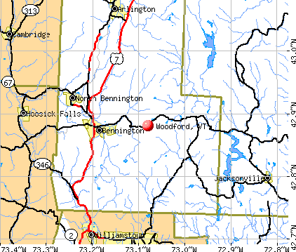
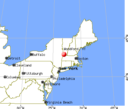
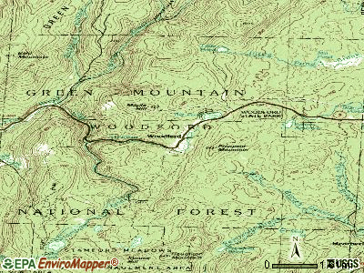
Woodford, Vermont
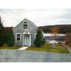
Woodford: This is just one of the many "camps" that ring around beautiful Woodford Lake in Vermont
Woodford
- add
your
Submit your own pictures of this town and show them to the world
- OSM Map
- General Map
- Google Map
- MSN Map
Population change since 2000: +2.4%
 |
| Males: 211 | |
| Females: 213 |
| Median resident age: | 47.1 years |
| Vermont median age: | 45.8 years |
Zip codes: 05201.
| Woodford: | $58,242 |
| VT: | $73,991 |
Estimated per capita income in 2022: $33,724 (it was $17,752 in 2000)
Woodford town income, earnings, and wages data
Estimated median house or condo value in 2022: $219,034 (it was $91,300 in 2000)
| Woodford: | $219,034 |
| VT: | $304,700 |
Mean prices in 2022: all housing units: $328,619; detached houses: $344,818; townhouses or other attached units: $277,995; in 2-unit structures: $228,670; in 3-to-4-unit structures: $413,467; in 5-or-more-unit structures: $239,659; mobile homes: $88,728
Detailed information about poverty and poor residents in Woodford, VT


- 41196.9%White alone
- 51.2%Asian alone
- 51.2%Hispanic
- 30.7%Two or more races

Races in Woodford detailed stats: ancestries, foreign born residents, place of birth
 Recent articles from our blog. Our writers, many of them Ph.D. graduates or candidates, create easy-to-read articles on a wide variety of topics.

 | Official Vermont Picture Thread (966 replies) |
| Possible Move From Upstate NY To VT (4 replies) |
| Vermont Weather (3779 replies) |
| Southern Vermont Campgrounds near Brattlboro? (11 replies) |
| Vermont property taxes: beyond ridiculous! (422 replies) |
| Vermonters hit hard by hurricane (102 replies) |
Latest news from Woodford, VT collected exclusively by city-data.com from local newspapers, TV, and radio stations
Ancestries: Irish (25.4%), French (18.8%), English (14.0%), German (13.8%), Italian (12.1%), Polish (5.1%).
Current Local Time: EST time zone
Elevation: 2215 feet
Land area: 47.5 square miles.
Population density: 8.9 people per square mile (very low).
8 residents are foreign born
| This town: | 1.9% |
| Vermont: | 3.8% |
| Woodford town: | 1.1% ($1,022) |
| Vermont: | 2.0% ($2,196) |
Nearest city with pop. 50,000+: Albany, NY  (39.0 miles , pop. 95,658).
Nearest city with pop. 200,000+: Boston, MA (108.4 miles , pop. 589,141).
Nearest city with pop. 1,000,000+: Bronx, NY (146.7 miles , pop. 1,332,650).
Nearest cities:
), ), Latitude: 42.88 N, Longitude: 73.08 W
Area code commonly used in this area: 802


Single-family new house construction building permits:
- 2017: 1 building, cost: $150,000
- 2016: 1 building, cost: $246,000
- 2010: 1 building, cost: $145,000
- 2009: 1 building, cost: $178,900
- 2008: 3 buildings, average cost: $182,400
- 2007: 2 buildings, average cost: $181,200
- 2006: 5 buildings, average cost: $113,400
- 2005: 2 buildings, average cost: $75,000
- 2004: 1 building, cost: $132,800
- 1999: 1 building, cost: $109,200


| Here: | 4.3% |
| Vermont: | 2.0% |


- Educational services (11.2%)
- Accommodation & food services (8.4%)
- Public administration (7.9%)
- Construction (7.5%)
- Health care (7.5%)
- Textile mills & textile products (6.1%)
- Food & beverage stores (4.7%)

- Construction (12.2%)
- Textile mills & textile products (11.3%)
- Accommodation & food services (11.3%)
- Educational services (9.6%)
- Transportation equipment (7.0%)
- Repair & maintenance (7.0%)
- Metal & metal products (6.1%)

- Health care (16.2%)
- Educational services (13.1%)
- Public administration (12.1%)
- Food & beverage stores (6.1%)
- Office supplies & stationery stores (5.1%)
- Accommodation & food services (5.1%)
- Religious, grantmaking, civic, professional, similar organizations (5.1%)

- Other office and administrative support workers, including supervisors (10.3%)
- Other management occupations, except farmers and farm managers (9.3%)
- Building and grounds cleaning and maintenance occupations (7.9%)
- Electrical equipment mechanics and other installation, maintenance, and repair workers, including supervisors (7.0%)
- Top executives (4.7%)
- Retail sales workers, except cashiers (4.7%)
- Assemblers and fabricators (4.7%)

- Electrical equipment mechanics and other installation, maintenance, and repair workers, including supervisors (13.0%)
- Other management occupations, except farmers and farm managers (8.7%)
- Building and grounds cleaning and maintenance occupations (7.0%)
- Preschool, kindergarten, elementary, and middle school teachers (5.2%)
- Advertising, marketing, promotions, public relations, and sales managers (4.3%)
- Top executives (4.3%)
- Retail sales workers, except cashiers (4.3%)

- Other office and administrative support workers, including supervisors (19.2%)
- Other management occupations, except farmers and farm managers (10.1%)
- Building and grounds cleaning and maintenance occupations (9.1%)
- Textile, apparel, and furnishings workers (8.1%)
- Top executives (5.1%)
- Retail sales workers, except cashiers (5.1%)
- Customer service representatives (5.1%)
Average climate in Woodford, Vermont
Based on data reported by over 4,000 weather stations


(lower is better)

Air Quality Index (AQI) level in 2022 was 56.8. This is better than average.
| City: | 56.8 |
| U.S.: | 72.6 |

Sulfur Dioxide (SO2) [ppb] level in 2012 was 0.789. This is significantly better than average. Closest monitor was 0.5 miles away from the city center.
| City: | 0.789 |
| U.S.: | 1.515 |

Ozone [ppb] level in 2022 was 29.1. This is about average. Closest monitor was 0.5 miles away from the city center.
| City: | 29.1 |
| U.S.: | 33.3 |

Particulate Matter (PM2.5) [µg/m3] level in 2022 was 5.66. This is significantly better than average. Closest monitor was 5.5 miles away from the city center.
| City: | 5.66 |
| U.S.: | 8.11 |
Tornado activity:
Woodford-area historical tornado activity is significantly above Vermont state average. It is 35% smaller than the overall U.S. average.
On 5/31/1998, a category F3 (max. wind speeds 158-206 mph) tornado 6.2 miles away from the Woodford town center injured 68 people and caused $71 million in damages.
On 8/28/1973, a category F4 (max. wind speeds 207-260 mph) tornado 36.5 miles away from the town center killed 4 people and injured 36 people and caused between $5,000,000 and $50,000,000 in damages.
Earthquake activity:
Woodford-area historical earthquake activity is significantly above Vermont state average. It is 69% smaller than the overall U.S. average.On 10/7/1983 at 10:18:46, a magnitude 5.3 (5.1 MB, 5.3 LG, 5.1 ML, Class: Moderate, Intensity: VI - VII) earthquake occurred 97.6 miles away from the city center
On 4/20/2002 at 10:50:47, a magnitude 5.3 (5.3 ML, Depth: 3.0 mi) earthquake occurred 116.9 miles away from Woodford center
On 4/20/2002 at 10:50:47, a magnitude 5.2 (5.2 MB, 4.2 MS, 5.2 MW, 5.0 MW) earthquake occurred 115.5 miles away from Woodford center
On 1/19/1982 at 00:14:42, a magnitude 4.7 (4.5 MB, 4.7 MD, 4.5 LG, Class: Light, Intensity: IV - V) earthquake occurred 85.8 miles away from Woodford center
On 10/16/2012 at 23:12:25, a magnitude 4.7 (4.7 ML, Depth: 10.0 mi) earthquake occurred 131.6 miles away from the city center
On 6/17/1991 at 08:53:16, a magnitude 4.1 (4.0 MB, 4.0 LG, Depth: 3.1 mi) earthquake occurred 83.2 miles away from Woodford center
Magnitude types: regional Lg-wave magnitude (LG), body-wave magnitude (MB), duration magnitude (MD), local magnitude (ML), surface-wave magnitude (MS), moment magnitude (MW)
Natural disasters:
The number of natural disasters in Bennington County (15) is near the US average (15).Major Disasters (Presidential) Declared: 10
Emergencies Declared: 2
Causes of natural disasters: Floods: 8, Storms: 8, Tropical Storms: 2, Winter Storms: 2, Hurricane: 1, Landslide: 1, Snowstorm: 1, Wind: 1, Other: 1 (Note: some incidents may be assigned to more than one category).
Hospitals and medical centers near Woodford:
- CRESCENT MANOR CARE CTRS (Nursing Home, about 6 miles away; BENNINGTON, VT)
- VERMONT VETERANS HOME (Nursing Home, about 7 miles away; BENNINGTON, VT)
- VNA AND HOSPICE OF SVHC (Home Health Center, about 7 miles away; BENNINGTON, VT)
- SOUTHWESTERN VERMONT MEDICAL CENTER Acute Care Hospitals (about 7 miles away; BENNINGTON, VT)
- BENNINGTON CONVEALESCENT CTR (Nursing Home, about 7 miles away; BENNINGTON, VT)
- BENNINGTON HEALTH AND REHAB (Nursing Home, about 7 miles away; BENNINGTON, VT)
- CENTERS FOR LIVING AND REHAB (Nursing Home, about 7 miles away; BENNINGTON, VT)
Colleges/universities with over 2000 students nearest to Woodford:
- Williams College (about 14 miles; Williamstown, MA; Full-time enrollment: 2,141)
- Rensselaer Polytechnic Institute (about 33 miles; Troy, NY; FT enrollment: 6,940)
- The Sage Colleges (about 34 miles; Troy, NY; FT enrollment: 2,499)
- Hudson Valley Community College (about 34 miles; Troy, NY; FT enrollment: 9,346)
- Siena College (about 37 miles; Loudonville, NY; FT enrollment: 3,153)
- SUNY Empire State College (about 39 miles; Saratoga Springs, NY; FT enrollment: 9,473)
- Skidmore College (about 39 miles; Saratoga Springs, NY; FT enrollment: 2,753)
Points of interest:
Notable locations in Woodford: Congdon Camp (A), Mellville Nanheim Shelter (B), Red Mill Brook Campground (C), Prospect Mountain Winter Sports Area (D), Yaw Brook Cabin (E), Camp Casino (F), Prospect Mountain Ski Center (G), Red Mill Brook Camping Area (H), Fay Fuller Camp (I), Thendara Camp (J), The Elbow (K), Greenwood Lodge and Tent Sites (L), Woodford Town Hall (M). Display/hide their locations on the map
Churches in Woodford include: Woodford Hollow Church (A), Union Church (B). Display/hide their locations on the map
Cemetery: Woodford Cemetery (1). Display/hide its location on the map
Lakes, reservoirs, and swamps: Little Pond (A), Mill Pond (B), Yaw Pond (C), Big Pond (D), Red Mill Pond (E), Bugbee Mill Pond (F), Adams Reservoir (G), Bugbee Pond (H). Display/hide their locations on the map
Streams, rivers, and creeks: Yaw Pond Brook (A), Stamford Stream (B), City Stream (C), Reservoir Brook (D), Little Pond Brook (E), Mill Pond Brook (F), Hell Hollow Brook (G), Bolles Brook (H), Bickford Hollow Brook (I). Display/hide their locations on the map
Park in Woodford: Woodford State Park (1). Display/hide its location on the map
Birthplace of: Franklin W. Olin - Baseball player.
| This town: | 2.4 people |
| Vermont: | 2.3 people |
| This town: | 65.0% |
| Whole state: | 62.5% |
| This town: | 10.6% |
| Whole state: | 9.2% |
Likely homosexual households (counted as self-reported same-sex unmarried-partner households)
- Lesbian couples: 0.6% of all households
- Gay men: 0.0% of all households
| This town: | 16.6% |
| Whole state: | 9.4% |
| This town: | 6.5% |
| Whole state: | 3.6% |
For population 15 years and over in Woodford:

- Never married: 23.4%
- Now married: 57.7%
- Separated: 0.0%
- Widowed: 5.3%
- Divorced: 13.6%
For population 25 years and over in Woodford:
- High school or higher: 81.2%
- Bachelor's degree or higher: 14.5%
- Graduate or professional degree: 4.7%
- Unemployed: 8.9%
- Mean travel time to work (commute): 23.1 minutes


| Here: | 10.7 |
| Vermont average: | 11.7 |
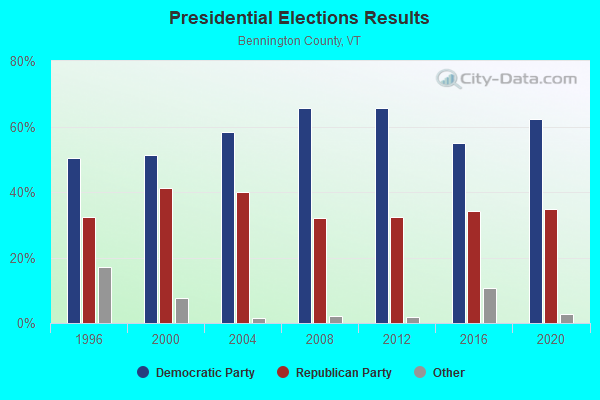
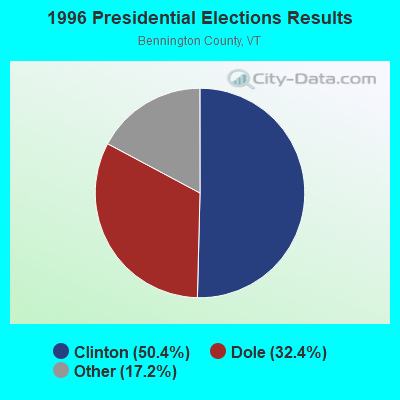
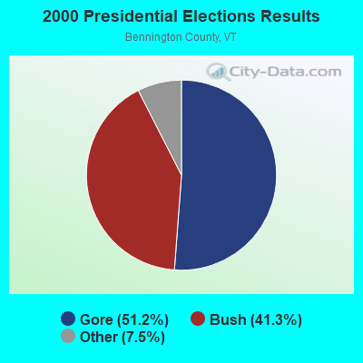
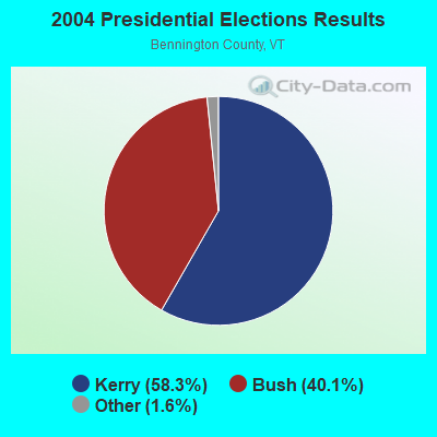
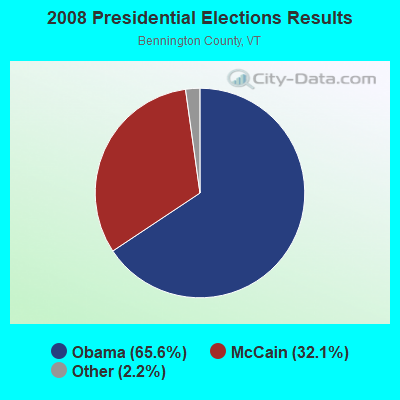
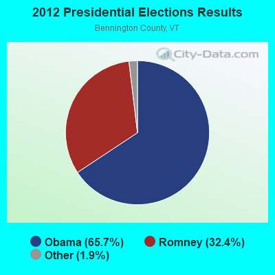
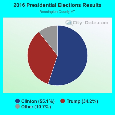
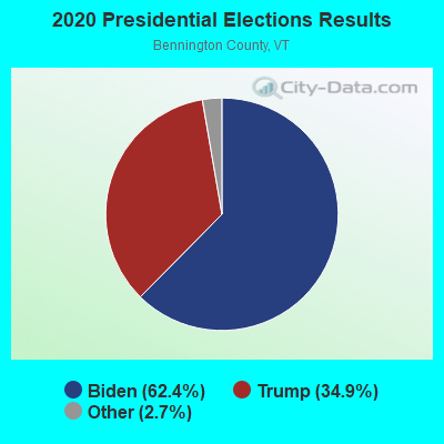
Graphs represent county-level data. Detailed 2008 Election Results
Religion statistics for Woodford, VT (based on Bennington County data)

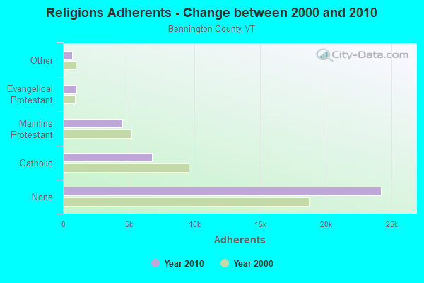
| Religion | Adherents | Congregations |
|---|---|---|
| Catholic | 6,742 | 8 |
| Mainline Protestant | 4,490 | 26 |
| Evangelical Protestant | 1,005 | 12 |
| Other | 693 | 5 |
| None | 24,195 | - |
Food Environment Statistics:
| Bennington County: | 3.85 / 10,000 pop. |
| Vermont: | 3.84 / 10,000 pop. |
| Bennington County: | 3.30 / 10,000 pop. |
| Vermont: | 1.95 / 10,000 pop. |
| Here: | 5.77 / 10,000 pop. |
| State: | 6.40 / 10,000 pop. |
| Bennington County: | 16.48 / 10,000 pop. |
| Vermont: | 11.52 / 10,000 pop. |
| Bennington County: | 8.4% |
| Vermont: | 6.8% |
| Here: | 22.9% |
| Vermont: | 22.3% |
| Here: | 11.6% |
| State: | 13.3% |
Strongest AM radio stations in Woodford:
- WNNZ (640 AM; 50 kW; WESTFIELD, MA; Owner: CLEAR CHANNEL BROADCASTING LICENSES, INC.)
- WGY (810 AM; 50 kW; SCHENECTADY, NY; Owner: CLEAR CHANNEL BROADCASTING LICENSES, INC.)
- WPTR (1540 AM; 50 kW; ALBANY, NY; Owner: KIMTRON, INC.)
- WBTN (1370 AM; 1 kW; BENNINGTON, VT; Owner: SOUTHERN VERMONT COLLEGE)
- WCRN (830 AM; 50 kW; WORCESTER, MA; Owner: CARTER BROADCASTING CORPORATION)
- WTIC (1080 AM; 50 kW; HARTFORD, CT; Owner: INFINITY RADIO OPERATIONS INC.)
- WRKO (680 AM; 50 kW; BOSTON, MA; Owner: ENTERCOM BOSTON LICENSE, LLC)
- WIZZ (1520 AM; daytime; 10 kW; GREENFIELD, MA; Owner: P. & M. RADIO, LLC)
- WVNE (760 AM; daytime; 25 kW; LEICESTER, MA; Owner: BLOUNT MASSCOM, INC.)
- WEEI (850 AM; 50 kW; BOSTON, MA; Owner: ENTERCOM BOSTON LICENSE, LLC)
- WALE (990 AM; 50 kW; GREENVILLE, RI; Owner: NORTH AMERICAN BROADCASTING CO., INC.)
- WKOX (1200 AM; 50 kW; FRAMINGHAM, MA; Owner: CAPSTAR TX LIMITED PARTNERSHIP)
- WROW (590 AM; 5 kW; ALBANY, NY; Owner: 6 JOHNSON ROAD LICENSES, INC.)
Strongest FM radio stations in Woodford:
- WVAY (100.7 FM; WILMINGTON, VT; Owner: GREAT NORTHERN RADIO, L.L.C.)
- WEQX (102.7 FM; MANCHESTER, VT; Owner: NORTHSHIRE COMMUNICATIONS, INC.)
- WJAN (95.1 FM; SUNDERLAND, VT; Owner: 6 JOHNSON ROAD LICENSES, INC.)
- WAMC-FM (90.3 FM; ALBANY, NY; Owner: WAMC)
- WZEC (97.5 FM; HOOSICK FALLS, NY; Owner: GREAT NORTHERN RADIO, LLC)
- WMNB (100.1 FM; NORTH ADAMS, MA; Owner: BERKSHIRE BROADCASTING CO., INC.)
- WRSY (101.5 FM; MARLBORO, VT; Owner: GREAT NORTHERN RADIO, L.L.C.)
- WJJR (98.1 FM; RUTLAND, VT; Owner: 6 JOHNSON ROAD LICENSES, INC.)
- WZRT (97.1 FM; RUTLAND, VT; Owner: CAPSTAR TX LIMITED PARTNERSHIP)
- WEBK (105.3 FM; KILLINGTON, VT; Owner: 6 JOHNSON ROAD LICENSES, INC.)
- WNGN (91.9 FM; ARGYLE, NY; Owner: NORTHEAST GOSPEL BROADCASTING INC)
- WVPR (89.5 FM; WINDSOR, VT; Owner: VERMONT PUBLIC RADIO)
- WHDQ (106.1 FM; CLAREMONT, NH; Owner: GREAT NORTHERN RADIO, L.L.C.)
- WGLV (91.7 FM; WOODSTOCK, VT; Owner: CHRISTIAN MINISTRIES INC)
- WHDQ-FM1 (106.1 FM; RUTLAND, VT; Owner: GREAT NORTHERN RADIO, L.L.C.)
- WKVT-FM (92.7 FM; BRATTLEBORO, VT; Owner: SAGA COMMUNICATIONS OF NEW ENGLAND, LLC)
- WCMK (91.9 FM; PUTNEY, VT; Owner: CHRISTIAN MINISTRIES INC)
- WPVQ (95.3 FM; GREENFIELD, MA; Owner: GREAT NORTHERN RADIO, L.L.C.)
- WBTN-FM (94.3 FM; BENNINGTON, VT; Owner: VERMONT PUBLIC RADIO)
- WKNE (103.7 FM; KEENE, NH; Owner: SAGA COMMUNICATIONS OF NEW ENGLAND, LLC)
TV broadcast stations around Woodford:
- WNGN-LP (Channel 26; TROY, NY; Owner: BRIAN A. LARSON)
- WCDC-TV (Channel 19; ADAMS, MA; Owner: YOUNG BROADCASTING OF ALBANY, INC.)
- W38DL (Channel 38; ADAMS, ETC., MA; Owner: WNYT-TV, LLC)
- W53AS (Channel 53; POWNAL, ETC., VT; Owner: VERMONT ETV, INC.)
- Woodford, Vermont
- Fatal accident count17
- Vehicles involved in fatal accidents28
- Fatal accidents involving drunk persons:4
- Fatalities22
- Persons involved in fatal accidents43
- Pedestrians involved in fatal accidents0
- Vermont average
- Fatal accident count1204
- Vehicles involved in fatal accidents1710
- Fatal accidents involving drunk persons497
- Fatalities1329
- Persons involved in fatal accidents2865
- Pedestrians involved in fatal accidents75
- National Bridge Inventory (NBI) Statistics
- 7Number of bridges
- 85ft / 26.3mTotal length
- $6,371,000Total costs
- 9,390Total average daily traffic
- 801Total average daily truck traffic
- 9,861Total future (year 2028) average daily traffic
FCC Registered Cell Phone Towers:
1- Woodford Cell Site .6 Miles East Of Rt 9 On Prospect Mtn (Lat: 42.874806 Lon: -73.067056), Structure height: 39.6 m, Call Sign: KNKQ277
Assigned Frequencies: 880.020 MHz, 891.510 MHz, 835.020 MHz, 846.510 MHzGrant Date: 09/08/2021, Expiration Date: 10/01/2031Registrant: Wilkinson Barker Knauer, LLP, 1800 M Street Nw, Suite 800n, Washington, DC 20036, Phone: (202) 383-3420, Fax: (202) 783-5851, Email:
FCC Registered Antenna Towers:
5- PETER M CONNOLLY, .6 Miles E Of Rt 9 On Prospect Mtn (Lat: 42.874722 Lon: -73.066944), Type: 39.6, Overall height: 36.6 m, Registrant: Holland & Knight LLP, Pconnoll@hklaw.Com, , Washi-ngton, Phone: (202) 955-3000
- PETER M CONNOLLY, .6 Miles E Of Rt 9 On Prospect Mtn (Lat: 42.874722 Lon: -73.066944), Type: 39.6, Overall height: 36.6 m, Registrant: Holland & Knight LLP, Pconnoll@hklaw.Com, , Washi-ngton, Phone: (202) 862-5989
- PETER M CONNOLLY, .6 Miles E Of Rt 9 On Prospect Mtn (Lat: 42.874722 Lon: -73.066944), Type: 39.6, Overall height: 36.6 m, Registrant: Holland & Knight LLP, Pconnolly@hklaw.Com, , Washi-ngton, Phone: (202) 862-5989
- Cayla Gamble, .6 Miles E Of Rt 9 On Prospect Mtn (Lat: 42.874722 Lon: -73.066944), Type: 39.6, Structure height: 50003 m, Overall height: 36.6 m, Registrant: Wilkinson Barker Knauer, LLP, Gwerner@wbklaw.Com, , Washi-ngton, Phone: (202) 383-3420
- .6 Miles E Of Rt 9 On Prospect Mtn (Lat: 42.874722 Lon: -73.066944), Type: 39.6, Overall height: 36.6 m, Registrant: United States Cellular Corporation, Linda.Hartman@koteen.Com, , Washi-ngton, Phone: (202) 467-5700
FCC Registered Broadcast Land Mobile Towers:
1- .4 Km Se Of Int Of Beech St And Burgess Rd (Lat: 42.865361 Lon: -73.145667), Type: Upole, Structure height: 15 m, Call Sign: WNNQ697,
Assigned Frequencies: 153.425 MHz, 153.455 MHz, 153.590 MHz, 153.635 MHz, 153.725 MHz, Grant Date: 08/21/2003, Expiration Date: 10/05/2013, Cancellation Date: 12/07/2013, Certifier: Donald J Rendall Jr, Registrant: Green Mountain Power Corporation, 7 Green Mountain Drive, Montpellier, VT 05602, Phone: (802) 229-7922, Fax: (802) 229-7841, Email:
FCC Registered Amateur Radio Licenses:
2- Call Sign: KB1BMY, Grant Date: 01/12/1995, Expiration Date: 01/12/2005, Cancellation Date: 01/13/2007, Registrant: Kristin M Briggs, Hcr 65 Box 888, Woodford, VT 05201
- Call Sign: KC1GGA, Licensee ID: L02049243, Grant Date: 09/02/2016, Expiration Date: 09/02/2026, Certifier: Anthony Bartholdi, Registrant: Anthony Bartholdi, 688 Vt Route 9, Woodford, VT 05201
FAA Registered Aircraft:
2- Aircraft: BEECH V35 (Category: Land, Seats: 6, Weight: Up to 12,499 Pounds, Speed: 150 mph), Engine: CONT MOTOR IO 520 SERIES (285 HP) (Reciprocating)
N-Number: 5487U, N5487U, N-5487U, Serial Number: D-8559, Year manufactured: 1967, Airworthiness Date: 09/30/1988, Certificate Issue Date: 10/28/2004
Registrant (Individual): Charles Suss, 360 Notch Rd, Woodford, VT 05201 - Aircraft: CESSNA 150 (Category: Land, Seats: 2, Weight: Up to 12,499 Pounds, Speed: 90 mph), Engine: CONT MOTOR 0-200 SERIES (100 HP) (Reciprocating)
N-Number: 6596T, N6596T, N-6596T, Serial Number: 17996, Airworthiness Date: 07/30/1960, Certificate Issue Date: 10/01/2018
Registrant (Co-Owned): Charles Suss, 360 Notch Rd, Woodford, VT 05201, Other Owners: Kate Balassie

- 72.9%Fuel oil, kerosene, etc.
- 17.3%Wood
- 9.8%Bottled, tank, or LP gas

- 76.5%Fuel oil, kerosene, etc.
- 11.8%Bottled, tank, or LP gas
- 11.8%Wood
Woodford compared to Vermont state average:
- Black race population percentage significantly below state average.
- Hispanic race population percentage below state average.
- Foreign-born population percentage significantly below state average.
- Length of stay since moving in significantly above state average.
- Number of rooms per house significantly below state average.
- House age significantly below state average.
- Number of college students below state average.
- Percentage of population with a bachelor's degree or higher below state average.