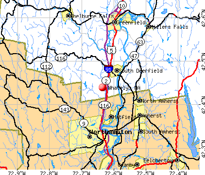
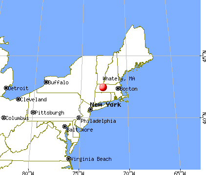
Whately, Massachusetts
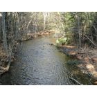
Whately: West Brook in Whately, MA
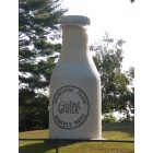
Whately: This is a landmark in Whately - the Milk Bottle is situated outside of town hall.
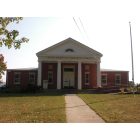
Whately: S. White Dickinson Memorial Library on Chestnut Plain Road, Whately, MA
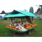
Whately: This is a farm stand located on Christian Laen Whately.
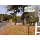
Whately: Signage at the corners of Chestnut Plain Road and Haydenville Rd., Whately, MA

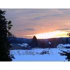
Whately: Winter Scene from Chestnut Mountain in Whately, MA
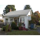
Whately: Whately Post Office, Whately, MA
Whately: Snow on Christian Lane farms
- add
your
Submit your own pictures of this town and show them to the world
- OSM Map
- General Map
- Google Map
- MSN Map
Population change since 2000: -4.9%
 |
| Males: 749 | |
| Females: 747 |
| Median resident age: | 48.3 years |
| Massachusetts median age: | 39.2 years |
Zip codes: 01373.
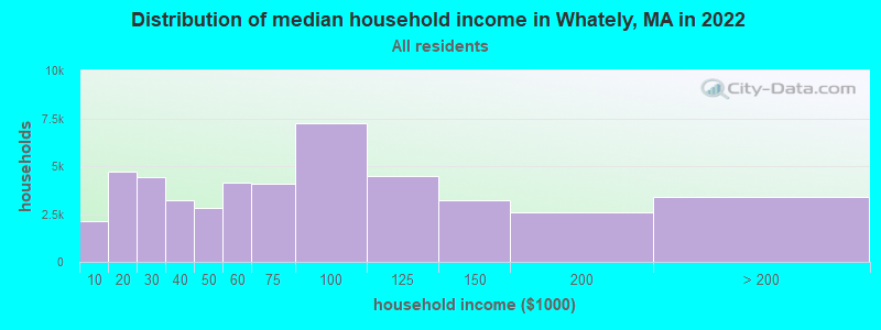
| Whately: | $101,625 |
| MA: | $94,488 |
Estimated per capita income in 2022: $50,697 (it was $27,826 in 2000)
Whately town income, earnings, and wages data
Estimated median house or condo value in 2022: $420,491 (it was $169,200 in 2000)
| Whately: | $420,491 |
| MA: | $534,700 |
Mean prices in 2022: all housing units: $313,377; detached houses: $324,224; townhouses or other attached units: $284,225; in 2-unit structures: $287,978; in 3-to-4-unit structures: $183,938; in 5-or-more-unit structures: $249,762; mobile homes: $62,200
Detailed information about poverty and poor residents in Whately, MA
Compare current foreclosures near Whately, MA:
| Photo | Address | Area | Beds / Baths | Price | Details |
|---|---|---|---|---|---|

|
#1
Lampblack Rd
Greenfield, MA 01301
|
2,078 sq. feet
|
1 baths 3 beds |
$355,000
|
show details |

|
#2
W Franklin St
Holyoke, MA 01040
|
1,558 sq. feet
|
1 baths 2 beds |
$234,900
|
show details |

|
#3
Cold Spring Rd
Southampton, MA 01073
|
2,736 sq. feet
|
1 baths 3 beds |
$284,900
|
show details |

|
#4
Elmer Rd
Conway, MA 01341
|
1,866 sq. feet
|
3 baths 3 beds |
show details | |

|
#5
West St
Greenfield, MA 01301
|
1,858 sq. feet
|
2 baths 3 beds |
show details | |

|
#6
Ridge Rd
South Hadley, MA 01075
|
1,056 sq. feet
|
2 baths 3 beds |
show details | |

|
#7
Pleasant St
Holyoke, MA 01040
|
4,057 sq. feet
|
3 baths 6 beds |
show details | |

|
#8
Central Park Dr
Holyoke, MA 01040
|
2,844 sq. feet
|
2 baths 4 beds |
show details | |

|
#9
Dressel Ave
Belchertown, MA 01007
|
1,098 sq. feet
|
1 baths 3 beds |
show details | |

|
#10
Birch Hill Rd
Florence, MA 01062
|
1,376 sq. feet
|
2 baths 4 beds |
show details |
| Photo | Address | Area | Beds / Baths | Price | Details |
|---|---|---|---|---|---|

|
#11
West St
Granby, MA 01033
|
940 sq. feet
|
2 baths 3 beds |
show details | |

|
#12
Sabans Rd
Conway, MA 01341
|
1,246 sq. feet
|
2 baths 3 beds |
show details | |

|
#13
Leverett Rd
Shutesbury, MA 01072
|
1,131 sq. feet
|
1 baths 3 beds |
show details | |

|
#14
Day Ave
Northampton, MA 01060
|
2,406 sq. feet
|
2 baths 4 beds |
show details | |

|
#15
Dwight St
Holyoke, MA 01040
|
3,194 sq. feet
|
2 baths 4 beds |
show details | |

|
#16
Stebbins St
Belchertown, MA 01007
|
1,011 sq. feet
|
1 baths 3 beds |
show details | |

|
#17
College St
Chicopee, MA 01020
|
1,902 sq. feet
|
2 baths 3 beds |
show details | |

|
#18
Hillside Rd
South Deerfield, MA 01373
|
1,449 sq. feet
|
3 baths 3 beds |
show details | |

|
#19
Mount Warner Rd
Hadley, MA 01035
|
1,008 sq. feet
|
1 baths 3 beds |
show details | |

|
#20
Graves Rd
Conway, MA 01341
|
1,440 sq. feet
|
1 baths 3 beds |
show details |
| Photo | Address | Area | Beds / Baths | Price | Details |
|---|---|---|---|---|---|

|
#21
Long Plain Road, Whately, Ma A/k/a 79 Long Plain Road
South Deerfield, MA 01373
|
1,909 sq. feet
|
2 baths 4 beds |
show details | |

|
#22
Hawley Rd
Ashfield, MA 01330
|
1,008 sq. feet
|
1 baths 3 beds |
show details | |

|
#23
Holyoke St
Easthampton, MA 01027
|
1,106 sq. feet
|
1 baths 2 beds |
show details | |

|
#24
Walnut St
Northfield, MA 01354
|
1,704 sq. feet
|
2 baths 4 beds |
show details | |

|
#25
Lyman St
South Hadley, MA 01075
|
1,152 sq. feet
|
2 baths 2 beds |
show details | |

|
#26
Dover Rd
South Hadley, MA 01075
|
1,492 sq. feet
|
1 baths 3 beds |
show details | |

|
#27
W State St
Granby, MA 01033
|
1,333 sq. feet
|
2 baths 3 beds |
show details | |

|
#28
Batchelor St
Granby, MA 01033
|
1,152 sq. feet
|
1 baths 4 beds |
show details | |

|
#29
W Parkview Dr
South Hadley, MA 01075
|
1,608 sq. feet
|
2 baths 3 beds |
show details | |

|
#30
Park St
Easthampton, MA 01027
|
1,064 sq. feet
|
1 baths 2 beds |
show details |
| Photo | Address | Area | Beds / Baths | Price | Details |
|---|---|---|---|---|---|

|
#31
Alvord Pl
South Hadley, MA 01075
|
1,358 sq. feet
|
3 baths 3 beds |
show details | |

|
#32
Log Plain Rd
Greenfield, MA 01301
|
960 sq. feet
|
1 baths 3 beds |
show details | |

|
#33
Alvord Pl # 505
South Hadley, MA 01075
|
1,358 sq. feet
|
2 baths 2 beds |
show details | |

|
#34
Pine St
South Hadley, MA 01075
|
2,357 sq. feet
|
2 baths 4 beds |
show details | |

|
#35
Alvord 505
South Hadley, MA 01075
|
1,358 sq. feet
|
2 baths 2 beds |
show details | |

|
#36
Mountain Ave
South Hadley, MA 01075
|
1,884 sq. feet
|
2 baths 3 beds |
show details | |

|
#37
Long Plain Rd
South Deerfield, MA 01373
|
1,909 sq. feet
|
2 baths 4 beds |
show details | |

|
#38
Kendall St
Granby, MA 01033
|
1,664 sq. feet
|
1 baths 4 beds |
show details | |

|
#39
Griswoldville St
Colrain, MA 01340
|
1,272 sq. feet
|
2 baths 5 beds |
show details | |

|
#40
Howard St
Belchertown, MA 01007
|
960 sq. feet
|
1 baths 3 beds |
show details |
| Photo | Address | Area | Beds / Baths | Price | Details |
|---|---|---|---|---|---|

|
#41
Hillside Ave
Holyoke, MA 01040
|
1,540 sq. feet
|
1 baths 3 beds |
show details | |

|
#42
Royal St
Chicopee, MA 01020
|
3,296 sq. feet
|
4 baths 7 beds |
show details | |

|
#43
Bald Mountain Rd
Bernardston, MA 01337
|
918 sq. feet
|
1 baths 2 beds |
show details | |

|
#44
Helen Ln
Belchertown, MA 01007
|
2,567 sq. feet
|
2 baths 4 beds |
show details | |

|
#45
9th Ave
Chicopee, MA 01020
|
1,056 sq. feet
|
1 baths 3 beds |
show details | |

|
#46
Elm St
Holyoke, MA 01040
|
3,617 sq. feet
|
3 baths 8 beds |
show details | |

|
#47
Jacksonville Rd
Colrain, MA 01340
|
1,108 sq. feet
|
1 baths 2 beds |
show details | |

|
#48
Beeler Ave
Chicopee, MA 01020
|
1,056 sq. feet
|
1 baths 3 beds |
show details | |

|
#49
Northampton St
Holyoke, MA 01040
|
2,532 sq. feet
|
2 baths 4 beds |
show details | |

|
Check over 1 million property listings on Foreclosure.com!
|
browse all offers | |||

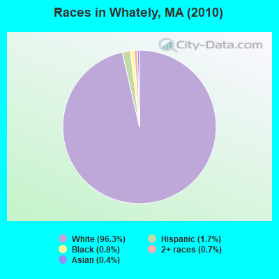
- 1,44096.3%White alone
- 261.7%Hispanic
- 120.8%Black alone
- 110.7%Two or more races
- 60.4%Asian alone
- 10.07%Native Hawaiian and Other
Pacific Islander alone
Races in Whately detailed stats: ancestries, foreign born residents, place of birth
According to our research of Massachusetts and other state lists, there were 3 registered sex offenders living in Whately, Massachusetts as of June 08, 2024.
The ratio of all residents to sex offenders in Whately is 499 to 1.
Type |
2009 |
2010 |
2011 |
2012 |
2013 |
2014 |
2015 |
2016 |
2017 |
2018 |
2019 |
2020 |
2021 |
2022 |
|---|---|---|---|---|---|---|---|---|---|---|---|---|---|---|
| Murders (per 100,000) | 0 (0.0) | 0 (0.0) | 0 (0.0) | 0 (0.0) | 0 (0.0) | 0 (0.0) | 0 (0.0) | 0 (0.0) | 0 (0.0) | 0 (0.0) | 0 (0.0) | 0 (0.0) | 0 (0.0) | 0 (0.0) |
| Rapes (per 100,000) | 0 (0.0) | 0 (0.0) | 0 (0.0) | 0 (0.0) | 0 (0.0) | 1 (66.3) | 0 (0.0) | 0 (0.0) | 0 (0.0) | 0 (0.0) | 0 (0.0) | 0 (0.0) | 0 (0.0) | 1 (61.0) |
| Robberies (per 100,000) | 0 (0.0) | 0 (0.0) | 0 (0.0) | 0 (0.0) | 0 (0.0) | 0 (0.0) | 0 (0.0) | 0 (0.0) | 0 (0.0) | 0 (0.0) | 0 (0.0) | 0 (0.0) | 0 (0.0) | 0 (0.0) |
| Assaults (per 100,000) | 1 (63.7) | 2 (133.7) | 1 (66.4) | 0 (0.0) | 6 (397.4) | 0 (0.0) | 0 (0.0) | 1 (65.7) | 1 (65.3) | 2 (128.3) | 1 (62.9) | 4 (254.1) | 1 (62.9) | 1 (61.0) |
| Burglaries (per 100,000) | 5 (318.3) | 4 (267.4) | 7 (465.1) | 5 (330.3) | 3 (198.7) | 1 (66.3) | 0 (0.0) | 4 (262.6) | 9 (587.9) | 2 (128.3) | 2 (125.9) | 3 (190.6) | 1 (62.9) | 2 (122.0) |
| Thefts (per 100,000) | 20 (1,273) | 11 (735.3) | 14 (930.2) | 18 (1,189) | 11 (728.5) | 8 (530.5) | 15 (986.8) | 11 (722.3) | 7 (457.2) | 6 (384.9) | 10 (629.3) | 7 (444.7) | 6 (377.1) | 5 (305.1) |
| Auto thefts (per 100,000) | 0 (0.0) | 2 (133.7) | 1 (66.4) | 0 (0.0) | 3 (198.7) | 0 (0.0) | 2 (131.6) | 1 (65.7) | 1 (65.3) | 1 (64.1) | 5 (314.7) | 1 (63.5) | 2 (125.7) | 0 (0.0) |
| Arson (per 100,000) | 1 (63.7) | 0 (0.0) | 0 (0.0) | 0 (0.0) | 0 (0.0) | 0 (0.0) | 0 (0.0) | 0 (0.0) | 0 (0.0) | 0 (0.0) | 0 (0.0) | 0 (0.0) | 0 (0.0) | 0 (0.0) |
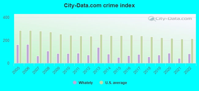
| City-Data.com crime index | 85.9 | 85.6 | 88.4 | 70.7 | 138.4 | 78.9 | 50.0 | 65.7 | 77.7 | 55.2 | 71.7 | 87.0 | 42.1 | 81.8 |
The City-Data.com crime index weighs serious crimes and violent crimes more heavily. Higher means more crime, U.S. average is 246.1. It adjusts for the number of visitors and daily workers commuting into cities.
Crime rate in Whately detailed stats: murders, rapes, robberies, assaults, burglaries, thefts, arson
Full-time law enforcement employees in 2013, including police officers: 2 (2 officers - 2 male; 0 female).
| Officers per 1,000 residents here: | 1.32 |
| Massachusetts average: | 2.51 |
 Recent articles from our blog. Our writers, many of them Ph.D. graduates or candidates, create easy-to-read articles on a wide variety of topics.

 | Big MA Ancestry Data Thread by Town (31 replies) |
| Favorite Massachusetts Street Views (35 replies) |
| Most similar and dissimilar adjacent towns and cities in MA? (34 replies) |
| Pioneer Valley: Wood Stoves + Well/Spring Water? (31 replies) |
| How Much Massachusetts Households Make Per Year: Census Data (37 replies) |
| What is Whately like? (6 replies) |
Latest news from Whately, MA collected exclusively by city-data.com from local newspapers, TV, and radio stations
Ancestries: Polish (27.9%), Irish (16.7%), English (15.5%), French (12.5%), German (10.2%), Italian (9.6%).
Current Local Time: EST time zone
Incorporated in 1771
Elevation: 290 feet
Land area: 20.2 square miles.
Population density: 74 people per square mile (very low).
49 residents are foreign born (2.4% Europe, 0.7% North America).
| This town: | 3.1% |
| Massachusetts: | 12.2% |
| Whately town: | 1.6% ($2,736) |
| Massachusetts: | 1.3% ($2,336) |
Nearest city with pop. 50,000+: Chicopee, MA  (19.1 miles , pop. 54,653).
Nearest city with pop. 200,000+: Boston, MA (79.5 miles , pop. 589,141).
Nearest city with pop. 1,000,000+: Bronx, NY (127.7 miles , pop. 1,332,650).
Nearest cities:
), ), ), Latitude: 42.44 N, Longitude: 72.64 W
Area code commonly used in this area: 413

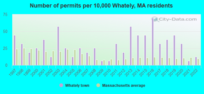
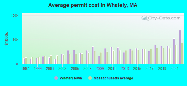
Single-family new house construction building permits:
- 2022: 2 buildings, average cost: $697,500
- 2021: 1 building, cost: $523,300
- 2020: 5 buildings, average cost: $373,300
- 2019: 7 buildings, average cost: $371,300
- 2018: 6 buildings, average cost: $397,300
- 2017: 5 buildings, average cost: $266,100
- 2016: 11 buildings, average cost: $307,500
- 2015: 7 buildings, average cost: $325,100
- 2014: 7 buildings, average cost: $312,700
- 2013: 9 buildings, average cost: $240,600
- 2012: 3 buildings, average cost: $343,900
- 2011: 5 buildings, average cost: $351,400
- 2010: 1 building, cost: $322,100
- 2009: 1 building, cost: $170,000
- 2008: 4 buildings, average cost: $360,700
- 2007: 3 buildings, average cost: $285,200
- 2006: 4 buildings, average cost: $230,600
- 2005: 2 buildings, average cost: $286,900
- 2004: 4 buildings, average cost: $283,500
- 2003: 9 buildings, average cost: $214,000
- 2002: 2 buildings, average cost: $104,900
- 2001: 6 buildings, average cost: $135,000
- 2000: 4 buildings, average cost: $159,700
- 1999: 3 buildings, average cost: $124,100
- 1998: 5 buildings, average cost: $106,900
- 1997: 7 buildings, average cost: $120,900
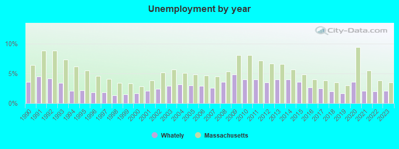
| Here: | 2.1% |
| Massachusetts: | 3.5% |
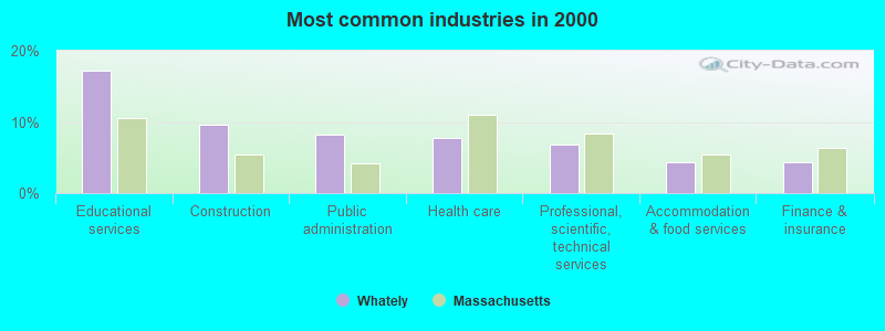
- Educational services (17.2%)
- Construction (9.6%)
- Public administration (8.2%)
- Health care (7.8%)
- Professional, scientific, technical services (6.7%)
- Accommodation & food services (4.4%)
- Finance & insurance (4.3%)
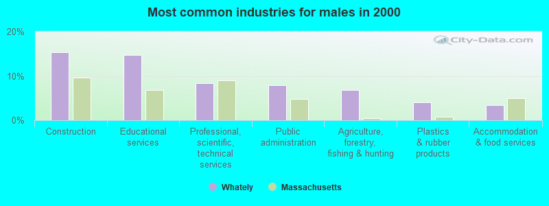
- Construction (15.4%)
- Educational services (14.8%)
- Professional, scientific, technical services (8.3%)
- Public administration (7.9%)
- Agriculture, forestry, fishing & hunting (6.9%)
- Plastics & rubber products (4.0%)
- Accommodation & food services (3.4%)
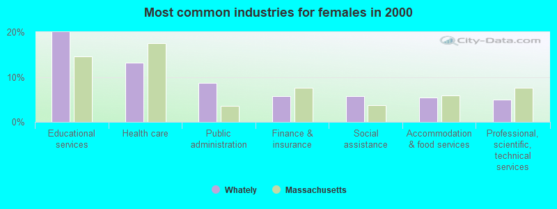
- Educational services (20.0%)
- Health care (13.2%)
- Public administration (8.6%)
- Finance & insurance (5.7%)
- Social assistance (5.7%)
- Accommodation & food services (5.5%)
- Professional, scientific, technical services (5.0%)
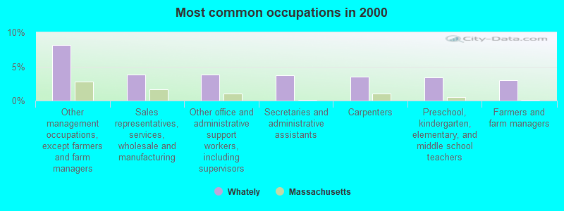
- Other management occupations, except farmers and farm managers (8.1%)
- Sales representatives, services, wholesale and manufacturing (3.9%)
- Other office and administrative support workers, including supervisors (3.9%)
- Secretaries and administrative assistants (3.7%)
- Carpenters (3.5%)
- Preschool, kindergarten, elementary, and middle school teachers (3.4%)
- Farmers and farm managers (3.0%)
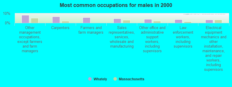
- Other management occupations, except farmers and farm managers (8.1%)
- Carpenters (6.7%)
- Farmers and farm managers (5.7%)
- Sales representatives, services, wholesale and manufacturing (4.7%)
- Other office and administrative support workers, including supervisors (3.8%)
- Law enforcement workers, including supervisors (3.6%)
- Electrical equipment mechanics and other installation, maintenance, and repair workers, including supervisors (3.2%)
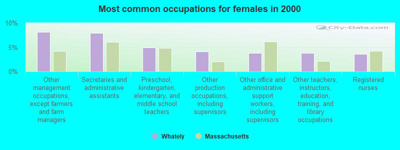
- Other management occupations, except farmers and farm managers (8.2%)
- Secretaries and administrative assistants (8.0%)
- Preschool, kindergarten, elementary, and middle school teachers (5.0%)
- Other production occupations, including supervisors (4.1%)
- Other office and administrative support workers, including supervisors (3.9%)
- Other teachers, instructors, education, training, and library occupations (3.9%)
- Registered nurses (3.6%)
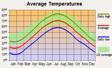
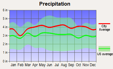
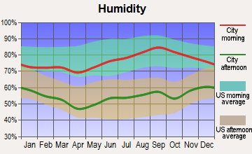
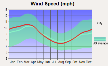
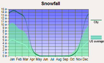
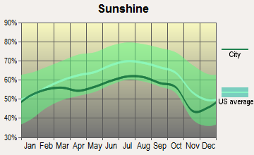
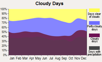
Average climate in Whately, Massachusetts
Based on data reported by over 4,000 weather stations
(lower is better)
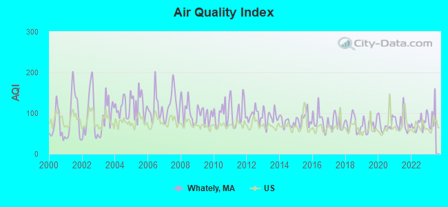
Air Quality Index (AQI) level in 2022 was 74.4. This is about average.
| City: | 74.4 |
| U.S.: | 72.6 |
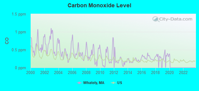
Carbon Monoxide (CO) [ppm] level in 2019 was 0.346. This is worse than average. Closest monitor was 17.7 miles away from the city center.
| City: | 0.346 |
| U.S.: | 0.251 |
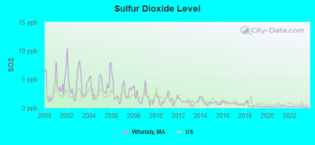
Sulfur Dioxide (SO2) [ppb] level in 2022 was 0.187. This is significantly better than average. Closest monitor was 7.5 miles away from the city center.
| City: | 0.187 |
| U.S.: | 1.515 |
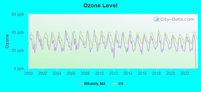
Ozone [ppb] level in 2022 was 26.9. This is better than average. Closest monitor was 6.5 miles away from the city center.
| City: | 26.9 |
| U.S.: | 33.3 |
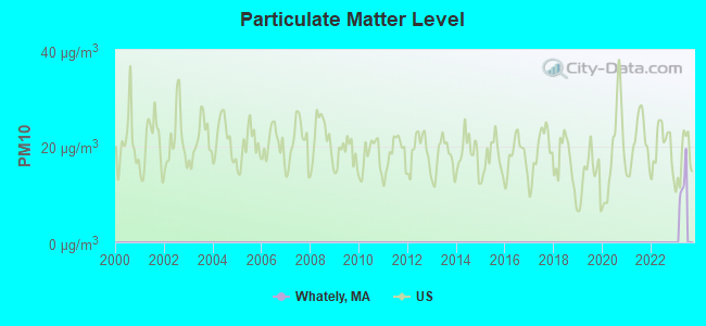
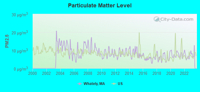
Particulate Matter (PM2.5) [µg/m3] level in 2022 was 7.01. This is about average. Closest monitor was 11.4 miles away from the city center.
| City: | 7.01 |
| U.S.: | 8.11 |
Tornado activity:
Whately-area historical tornado activity is above Massachusetts state average. It is 10% smaller than the overall U.S. average.
On 6/9/1953, a category F4 (max. wind speeds 207-260 mph) tornado 23.8 miles away from the Whately town center killed 90 people and injured 1228 people and caused between $50,000,000 and $500,000,000 in damages.
On 10/3/1979, a category F4 tornado 27.5 miles away from the town center killed 3 people and injured 500 people and caused between $50,000,000 and $500,000,000 in damages.
Earthquake activity:
Whately-area historical earthquake activity is significantly above Massachusetts state average. It is 70% smaller than the overall U.S. average.On 10/7/1983 at 10:18:46, a magnitude 5.3 (5.1 MB, 5.3 LG, 5.1 ML, Class: Moderate, Intensity: VI - VII) earthquake occurred 135.3 miles away from Whately center
On 4/20/2002 at 10:50:47, a magnitude 5.3 (5.3 ML, Depth: 3.0 mi) earthquake occurred 152.7 miles away from Whately center
On 4/20/2002 at 10:50:47, a magnitude 5.2 (5.2 MB, 4.2 MS, 5.2 MW, 5.0 MW) earthquake occurred 151.4 miles away from the city center
On 1/19/1982 at 00:14:42, a magnitude 4.7 (4.5 MB, 4.7 MD, 4.5 LG, Class: Light, Intensity: IV - V) earthquake occurred 89.9 miles away from the city center
On 10/16/2012 at 23:12:25, a magnitude 4.7 (4.7 ML, Depth: 10.0 mi) earthquake occurred 128.0 miles away from Whately center
On 10/2/1994 at 11:27:22, a magnitude 3.7 (3.5 LG, 3.7 LG, Depth: 6.2 mi, Class: Light, Intensity: II - III) earthquake occurred 19.5 miles away from Whately center
Magnitude types: regional Lg-wave magnitude (LG), body-wave magnitude (MB), duration magnitude (MD), local magnitude (ML), surface-wave magnitude (MS), moment magnitude (MW)
Natural disasters:
The number of natural disasters in Franklin County (20) is greater than the US average (15).Major Disasters (Presidential) Declared: 9
Emergencies Declared: 10
Causes of natural disasters: Floods: 5, Storms: 5, Hurricanes: 4, Snowstorms: 4, Winter Storms: 3, Blizzards: 2, Snows: 2, Snowfall: 1, Tropical Storm: 1, Wind: 1, Other: 1 (Note: some incidents may be assigned to more than one category).
Hospitals and medical centers near Whately:
- COZY CORNER NURSING AND REHABILITATION CENTER (Nursing Home, about 4 miles away; SUNDERLAND, MA)
- HOSPICE OF THE FISHER HOME (Hospital, about 6 miles away; AMHERST, MA)
- OVERLOOK AT NORTHAMPTON (Nursing Home, about 7 miles away; LEEDS, MA)
- LINDA MANOR EXTENDED CARE FACILITY (Nursing Home, about 7 miles away; LEEDS, MA)
- SERVICENET HOMECARE (Home Health Center, about 7 miles away; NORTHAMPTON, MA)
- CENTER FOR EXTENDED CARE AT AMHERST (Nursing Home, about 8 miles away; AMHERST, MA)
- NORTHAMPTON VA MEDICAL CENTER (Hospital, Acute Care - Veterans Administration, about 8 miles away; LEEDS, MA)
Colleges/universities with over 2000 students nearest to Whately:
- University of Massachusetts-Amherst (about 7 miles; Amherst, MA; Full-time enrollment: 26,583)
- Smith College (about 9 miles; Northampton, MA; FT enrollment: 3,549)
- Mount Holyoke College (about 14 miles; South Hadley, MA; FT enrollment: 2,573)
- Holyoke Community College (about 18 miles; Holyoke, MA; FT enrollment: 4,911)
- Westfield State University (about 24 miles; Westfield, MA; FT enrollment: 5,548)
- American International College (about 24 miles; Springfield, MA; FT enrollment: 2,733)
- Springfield Technical Community College (about 24 miles; Springfield, MA; FT enrollment: 4,750)
Public elementary/middle school in Whately:
- WHATELY ELEMENTARY (Students: 124, Location: 273 LONG PLAIN RD., Grades: PK-6)
Points of interest:
Notable locations in Whately: Quontquont Farm (A), Whately Fire Department (B), Whately Elementary School Library (C). Display/hide their locations on the map
Cemeteries: Whately Center Cemetery (1), Holy Ghost Cemetery (2), East Whately Cemetery (3). Display/hide their locations on the map
Reservoirs and swamps: Northampton Reservoir (A), Roaring Brook Reservoir (B), Northampton Reservoir Upper (C), Great Swamp (D). Display/hide their locations on the map
Streams, rivers, and creeks: Jimmy Nolan Brook (A), Great Swamp Brook (B), Ground Brook (C), Esther Brook (D), Avery Brook (E), Second Brook (F), Sugerloaf Brook (G), Bloody Brook (H), First Brook (I). Display/hide their locations on the map
Birthplace of: Aaron E. Waite - Politician, Chris Haffey - Inline skater.
Drinking water stations with addresses in Whately and their reported violations in the past:
WHATELY WATER DEPT (Population served: 1,000, Groundwater):Past monitoring violations:WHATELY WATER DISTRICT (Address: NICHOLAS JONES , Population served: 100, Groundwater):
- One regular monitoring violation
Past health violations:Past monitoring violations:
- MCL, Monthly (TCR) - In JUN-2014, Contaminant: Coliform
- MCL, Acute (TCR) - In JUL-2013, Contaminant: Coliform. Follow-up actions: St AO (w/o penalty) issued (2 times from JUL-15-2013 to JUL-19-2013)
- Monitoring, Repeat Major (TCR) - In MAY-2013, Contaminant: Coliform (TCR)
- One minor monitoring violation
| This town: | 2.4 people |
| Massachusetts: | 2.5 people |
| This town: | 64.7% |
| Whole state: | 63.0% |
| This town: | 9.6% |
| Whole state: | 7.0% |
Likely homosexual households (counted as self-reported same-sex unmarried-partner households)
- Lesbian couples: 1.6% of all households
- Gay men: 0.3% of all households
| This town: | 3.0% |
| Whole state: | 9.3% |
| This town: | 2.3% |
| Whole state: | 4.4% |
10 people in agriculture workers' dormitories on farms in 2000
For population 15 years and over in Whately:
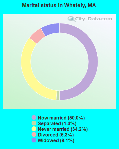
- Never married: 34.2%
- Now married: 50.0%
- Separated: 1.4%
- Widowed: 8.1%
- Divorced: 6.3%
For population 25 years and over in Whately:
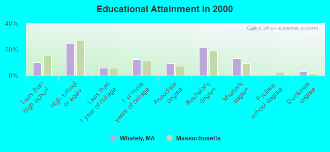
- High school or higher: 89.9%
- Bachelor's degree or higher: 37.6%
- Graduate or professional degree: 16.4%
- Unemployed: 4.7%
- Mean travel time to work (commute): 22.5 minutes
| Here: | 11.2 |
| Massachusetts average: | 13.1 |


Graphs represent county-level data. Detailed 2008 Election Results
Religion statistics for Whately, MA (based on Franklin County data)


| Religion | Adherents | Congregations |
|---|---|---|
| Catholic | 16,509 | 15 |
| Mainline Protestant | 4,617 | 38 |
| Evangelical Protestant | 2,079 | 20 |
| Other | 1,580 | 21 |
| None | 46,587 | - |
Food Environment Statistics:
| This county: | 3.63 / 10,000 pop. |
| Massachusetts: | 1.98 / 10,000 pop. |
| Franklin County: | 0.14 / 10,000 pop. |
| Massachusetts: | 0.05 / 10,000 pop. |
| Franklin County: | 1.67 / 10,000 pop. |
| State: | 2.22 / 10,000 pop. |
| Franklin County: | 3.21 / 10,000 pop. |
| State: | 1.77 / 10,000 pop. |
| Franklin County: | 8.10 / 10,000 pop. |
| Massachusetts: | 8.76 / 10,000 pop. |
| Franklin County: | 7.5% |
| Massachusetts: | 8.1% |
| This county: | 22.2% |
| Massachusetts: | 22.5% |
| Franklin County: | 15.1% |
| Massachusetts: | 16.5% |
| Businesses in Whately, MA | ||||
| Name | Count | Name | Count | |
|---|---|---|---|---|
| Circle K | 1 | U-Haul | 1 | |
| FedEx | 1 | UPS | 1 | |
Strongest AM radio stations in Whately:
- WNNZ (640 AM; 50 kW; WESTFIELD, MA; Owner: CLEAR CHANNEL BROADCASTING LICENSES, INC.)
- WIZZ (1520 AM; daytime; 10 kW; GREENFIELD, MA; Owner: P. & M. RADIO, LLC)
- WCRN (830 AM; 50 kW; WORCESTER, MA; Owner: CARTER BROADCASTING CORPORATION)
- WPNI (1430 AM; 5 kW; AMHERST, MA; Owner: WESTERN MASSACHUSETTS RADIO COMPANY)
- WVNE (760 AM; daytime; 25 kW; LEICESTER, MA; Owner: BLOUNT MASSCOM, INC.)
- WHYN (560 AM; 5 kW; SPRINGFIELD, MA; Owner: CLEAR CHANNEL BROADCASTING LICENSES, INC.)
- WTIC (1080 AM; 50 kW; HARTFORD, CT; Owner: INFINITY RADIO OPERATIONS INC.)
- WACE (730 AM; 5 kW; CHICOPEE, MA; Owner: CARTER BROADCASTING CORP.)
- WRKO (680 AM; 50 kW; BOSTON, MA; Owner: ENTERCOM BOSTON LICENSE, LLC)
- WALE (990 AM; 50 kW; GREENVILLE, RI; Owner: NORTH AMERICAN BROADCASTING CO., INC.)
- WEEI (850 AM; 50 kW; BOSTON, MA; Owner: ENTERCOM BOSTON LICENSE, LLC)
- WGY (810 AM; 50 kW; SCHENECTADY, NY; Owner: CLEAR CHANNEL BROADCASTING LICENSES, INC.)
- WHMP (1400 AM; 1 kW; NORTHAMPTON, MA; Owner: SAGA COMMUNICATIONS OF NEW ENGLAND, LLC)
Strongest FM radio stations in Whately:
- WLZX (99.3 FM; NORTHAMPTON, MA; Owner: SAGA COMMUNICATIONS OF NEW ENGLAND, LLC)
- WFCR (88.5 FM; AMHERST, MA; Owner: UNIVERSITY OF MASSACHUSETTS)
- WEIB (106.3 FM; NORTHAMPTON, MA; Owner: CUTTING EDGE BROADCASTING, INC.)
- WHYN-FM (93.1 FM; SPRINGFIELD, MA; Owner: CLEAR CHANNEL BROADCASTING LICENSES, INC.)
- WRNX (100.9 FM; AMHERST, MA; Owner: WESTERN MASSACHUSETTS RADIO COMPANY)
- WAMH (89.3 FM; AMHERST, MA; Owner: TRUSTEES OF AMHERST COLLEGE)
- WGAJ (91.7 FM; DEERFIELD, MA; Owner: TRUATEES OF DEERFIELD ACADEMY)
- W246AM (97.1 FM; AMHERST, MA; Owner: GREAT NORTHERN RADIO, LLC)
- WHAI (98.3 FM; GREENFIELD, MA; Owner: SAGA COMMUNICATIONS OF NEW ENGLAND, LLC)
- WRSI (93.9 FM; TURNERS FALLS, MA; Owner: GREAT NORTHERN RADIO, LLC)
- WAMC-FM (90.3 FM; ALBANY, NY; Owner: WAMC)
- WPVQ (95.3 FM; GREENFIELD, MA; Owner: GREAT NORTHERN RADIO, L.L.C.)
- WEQX (102.7 FM; MANCHESTER, VT; Owner: NORTHSHIRE COMMUNICATIONS, INC.)
- WVAY (100.7 FM; WILMINGTON, VT; Owner: GREAT NORTHERN RADIO, L.L.C.)
- WJAN (95.1 FM; SUNDERLAND, VT; Owner: 6 JOHNSON ROAD LICENSES, INC.)
- WAQY (102.1 FM; SPRINGFIELD, MA; Owner: SAGA COMMUNICATIONS OF NEW ENGLAND, LLC)
- WMUA (91.1 FM; AMHERST, MA; Owner: UNIVERSITY OF MASSACHUSETTS)
- WYRY (104.9 FM; HINSDALE, NH; Owner: TRI-VALLEY BROADCASTING CORPORATION)
- WRSY (101.5 FM; MARLBORO, VT; Owner: GREAT NORTHERN RADIO, L.L.C.)
- WAAF (107.3 FM; WORCESTER, MA; Owner: ENTERCOM BOSTON LICENSE, LLC)
TV broadcast stations around Whately:
- WYDN (Channel 48; WORCESTER, MA; Owner: EDUCATIONAL PUBLIC TV CORPORATION)
- WTIC-TV (Channel 61; HARTFORD, CT; Owner: TRIBUNE TELEVISION COMPANY)
- WUNI (Channel 27; WORCESTER, MA; Owner: ENTRAVISION HOLDINGS, LLC)
- WWLP (Channel 22; SPRINGFIELD, MA; Owner: WWLP BROADCASTING, LLC)
- W35BK (Channel 35; PLAINFIELD, MA; Owner: LYDIA SYLVANE STOCKWELL)
- W67DF (Channel 67; SPRINGFIELD, MA; Owner: TRINITY BROADCASTING NETWORK)
- WGGB-TV (Channel 40; SPRINGFIELD, MA; Owner: WGGB LICENSEE, LLC)
- WGBY-TV (Channel 57; SPRINGFIELD, MA; Owner: WGBH EDUCATIONAL FOUNDATION)
- Whately, Massachusetts
- Fatal accident count18
- Vehicles involved in fatal accidents21
- Fatal accidents involving drunk persons:9
- Fatalities23
- Persons involved in fatal accidents28
- Pedestrians involved in fatal accidents2
- Massachusetts average
- Fatal accident count7056
- Vehicles involved in fatal accidents9938
- Fatal accidents involving drunk persons2096
- Fatalities7553
- Persons involved in fatal accidents16393
- Pedestrians involved in fatal accidents1167
- National Bridge Inventory (NBI) Statistics
- 17Number of bridges
- 184ft / 55.8mTotal length
- $41,579,000Total costs
- 47,688Total average daily traffic
- 2,938Total average daily truck traffic
- 61,094Total future (year 2031) average daily traffic
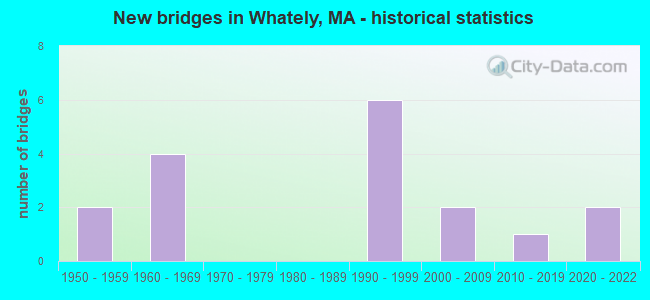
- New bridges - historical statistics
- 21950-1959
- 41960-1969
- 61990-1999
- 22000-2009
- 12010-2019
- 22020-2022
FCC Registered Cell Phone Towers:
1 (See the full list of FCC Registered Cell Phone Towers in Whately)FCC Registered Antenna Towers:
9 (See the full list of FCC Registered Antenna Towers)FCC Registered Microwave Towers:
3- STATION, Lat: 42.437583 Lon: -72.655083, Overall height: 6.1 m, Call Sign: WNTV329,
Assigned Frequencies: 956.331 MHz, 956.331 MHz, Grant Date: 04/22/2009, Expiration Date: 05/16/2019, Cancellation Date: 07/20/2019, Registrant: Itron, Inc., 2818 N. Sullivan Rd., Spokane, WA 99216, Phone: (509) 891-3636, Fax: (509) 891-3334, Email:
- Primary, Lat: 42.437778 Lon: -72.646417, Type: Tower, Structure height: 42 m, Call Sign: WQND259,
Assigned Frequencies: 3650.00 MHz, Grant Date: 12/24/2010, Expiration Date: 12/20/2020, Cancellation Date: 02/20/2021, Certifier: Richard C Chedester, Registrant: Whately Wimax Association, 260 Haydenvelle Rd, Whately, MA 01093, Phone: (413) 665-0176, Email:
- CT13XC243, 79 Christian Ln. Lot 9 (Lat: 42.445667 Lon: -72.620750), Type: Mtower, Structure height: 53.9 m, Call Sign: WQPU531,
Assigned Frequencies: 10895.0 MHz, 10935.0 MHz, 10895.0 MHz, 10935.0 MHz, 10895.0 MHz, 10935.0 MHz, Grant Date: 08/17/2012, Expiration Date: 08/17/2022, Cancellation Date: 08/10/2022, Certifier: David Werblow, Registrant: Dla Piper LLP, 500 8th Street, Nw, Washington, DC 20004, Phone: (202) 799-4216, Fax: (202) 799-5616, Email:
FCC Registered Amateur Radio Licenses:
4- Call Sign: N1OWI, Licensee ID: L00625680, Grant Date: 02/04/2013, Expiration Date: 04/20/2023, Certifier: Wendy S Curtis, Registrant: Wendy S Curtis, Whately, MA 01093
- Call Sign: KB1FVU, Licensee ID: L00295881, Grant Date: 11/02/2000, Expiration Date: 11/02/2010, Cancellation Date: 11/03/2012, Certifier: Mark B Boyer, Registrant: Mark B Boyer, Whately, MA 01093
- Call Sign: KB1GQZ, Licensee ID: L00348355, Grant Date: 04/19/2001, Expiration Date: 04/19/2011, Cancellation Date: 04/20/2013, Certifier: Theodore J Boyer, Registrant: Theodore J Boyer, 33 Webber Rd, Whately, MA 01093
- Call Sign: KB1IPR, Licensee ID: L00548227, Grant Date: 12/10/2022, Expiration Date: 07/22/2032, Certifier: Richard C Chedester, Registrant: Richard C Chedester, Whately, MA 01093
FAA Registered Aircraft:
7- Aircraft: CESSNA 150E (Category: Land, Seats: 2, Weight: Up to 12,499 Pounds, Speed: 90 mph), Engine: CONT MOTOR 0-200 SERIES (100 HP) (Reciprocating)
N-Number: 150MK, N150MK, N-150MK, Serial Number: 15061488, Year manufactured: 1965, Airworthiness Date: 06/08/1965, Certificate Issue Date: 05/10/2013
Registrant (Individual): Michael Kuehlmuss, Po Box 815, Whately, MA 01093 - Aircraft: CESSNA 150L (Category: Land, Seats: 2, Weight: Up to 12,499 Pounds, Speed: 90 mph), Engine: CONT MOTOR 0-200 SERIES (100 HP) (Reciprocating)
N-Number: 19101, N19101, N-19101, Serial Number: 15074170, Year manufactured: 1972, Airworthiness Date: 12/27/1972, Certificate Issue Date: 04/02/2014
Registrant (Individual): Randall S Nickerson, Po Box 123, Whately, MA 01093 - Aircraft: PIPER PA-22-150 (Category: Land, Seats: 4, Weight: Up to 12,499 Pounds, Speed: 94 mph), Engine: LYCOMING 0-320 SERIES (180 HP) (Reciprocating)
N-Number: 2836P, N2836P, N-2836P, Serial Number: 22-3133, Year manufactured: 1955, Airworthiness Date: 06/20/1956, Certificate Issue Date: 05/10/2002
Registrant (Individual): Michael Kuehlmuss, Po Box 815, Whately, MA 01093 - Aircraft: MICHAEL KUEHLMUSS 37K-16 (Category: Land, Seats: 2, Weight: Up to 12,499 Pounds), Engine: None
N-Number: 3QX, N3QX, N-3QX, Serial Number: 1, Year manufactured: 2017, Airworthiness Date: 07/11/2017, Certificate Issue Date: 02/11/2015
Registrant (Individual): Michael Kuehlmuss, Po Box 815, Whately, MA 01093 - Aircraft: RAVEN S55A (Category: Land, Weight: Up to 12,499 Pounds, Speed: 60 mph), Engine: None
N-Number: 74RS, N74RS, N-74RS, Serial Number: S55A-233, Year manufactured: 1975, Airworthiness Date: 04/02/1975, Certificate Issue Date: 05/31/2007
Registrant (Co-Owned): Michael Kuehlmuss, Po Box 815, Whately, MA 01093, Other Owners: Wendy S Curtis - Aircraft: SHARPE SA-1 (Category: Land, Seats: 2, Weight: Up to 12,499 Pounds, Speed: 85 mph), Engine: CONT MOTOR C85 SERIES (85 HP) (Reciprocating)
N-Number: 889, N889, N-889, Serial Number: 1, Year manufactured: 1957, Airworthiness Date: 06/27/1980, Certificate Issue Date: 04/24/2003
Registrant (Individual): Michael Kuehlmuss, Po Box 815, Whately, MA 01093 - Aircraft: PIPER PA-24-260 (Category: Land, Seats: 4, Weight: Up to 12,499 Pounds, Speed: 135 mph), Engine: LYCOMING TI0-540 SER (310 HP) (Reciprocating)
N-Number: 9317P, N9317P, N-9317P, Serial Number: 24-4813, Year manufactured: 1969, Airworthiness Date: 05/07/1969, Certificate Issue Date: 10/14/1988
Registrant (Individual): John H Futter, Po Box 293, Whately, MA 01093
2002 - 2018 National Fire Incident Reporting System (NFIRS) incidents
- Fire incident types reported to NFIRS in Whately, MA
- 10745.3%Outside Fires
- 8736.9%Structure Fires
- 3715.7%Mobile Property/Vehicle Fires
- 52.1%Other
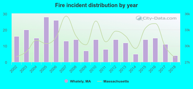 According to the data from the years 2002 - 2018 the average number of fires per year is 14. The highest number of reported fires - 28 took place in 2005, and the least - 4 in 2018. The data has a dropping trend.
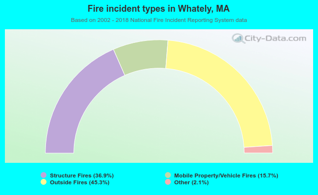 When looking into fire subcategories, the most incidents belonged to: Outside Fires (45.3%), and Structure Fires (36.9%).
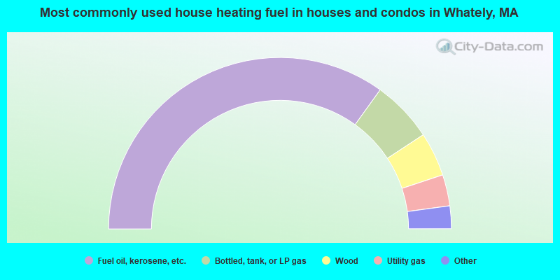
- 69.9%Fuel oil, kerosene, etc.
- 11.6%Bottled, tank, or LP gas
- 8.3%Wood
- 5.9%Utility gas
- 3.5%Electricity
- 0.7%Coal or coke
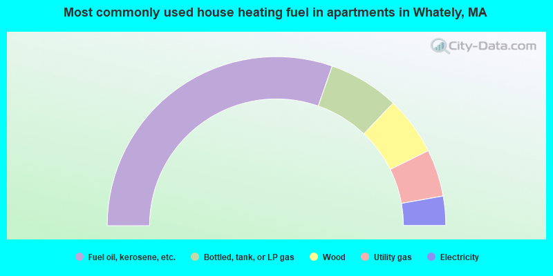
- 60.7%Fuel oil, kerosene, etc.
- 13.5%Bottled, tank, or LP gas
- 11.2%Wood
- 9.0%Utility gas
- 5.6%Electricity
Whately compared to Massachusetts state average:
- Unemployed percentage significantly below state average.
- Black race population percentage significantly below state average.
- Hispanic race population percentage significantly below state average.
- Median age significantly above state average.
- Foreign-born population percentage significantly below state average.
- Renting percentage significantly below state average.
- Length of stay since moving in significantly above state average.
- Number of rooms per house significantly below state average.
- House age significantly below state average.

|
Total of 3 patent applications in 2008-2024.