West Haskell, Oklahoma
Submit your own pictures of this place and show them to the world
- OSM Map
- General Map
- Google Map
- MSN Map

| Males: 1,728 | |
| Females: 1,678 |
| Median resident age: | 41.7 years |
| Oklahoma median age: | 35.5 years |
Zip code: 74462
| West Haskell: | $48,794 |
| OK: | $59,673 |
Estimated per capita income in 2022: $24,316 (it was $13,556 in 2000)
West Haskell CCD income, earnings, and wages data
Estimated median house or condo value in 2022: $132,949 (it was $50,600 in 2000)
| West Haskell: | $132,949 |
| OK: | $191,700 |
Mean prices in 2022: all housing units: $209,078; detached houses: $234,022; townhouses or other attached units: $144,987; mobile homes: $105,313; occupied boats, rvs, vans, etc.: $83,700
Detailed information about poverty and poor residents in West Haskell, OK


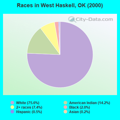
- 2,51775.6%White alone
- 47214.2%American Indian alone
- 2487.4%Two or more races
- 682.0%Black alone
- 160.5%Hispanic
- 50.2%Asian alone
- 30.09%Other race alone
Races in West Haskell detailed stats: ancestries, foreign born residents, place of birth
 Recent articles from our blog. Our writers, many of them Ph.D. graduates or candidates, create easy-to-read articles on a wide variety of topics.
Current Local Time: CST time zone
Land area: 211.7 square miles.
Population density: 16 people per square mile (very low).

| West Haskell CCD: | 0.4% ($222) |
| Oklahoma: | 0.8% ($523) |
Nearest city with pop. 50,000+: Fort Smith, AR  (51.1 miles , pop. 80,268).
Nearest city with pop. 200,000+: Tulsa, OK (73.4 miles , pop. 393,049).
Nearest city with pop. 1,000,000+: Dallas, TX (187.9 miles , pop. 1,188,580).
Nearest cities:
), ), ), Latitude: 35.21 N, Longitude: 95.28 W
Area code commonly used in this area: 918

| Here: | 5.1% |
| Oklahoma: | 3.2% |
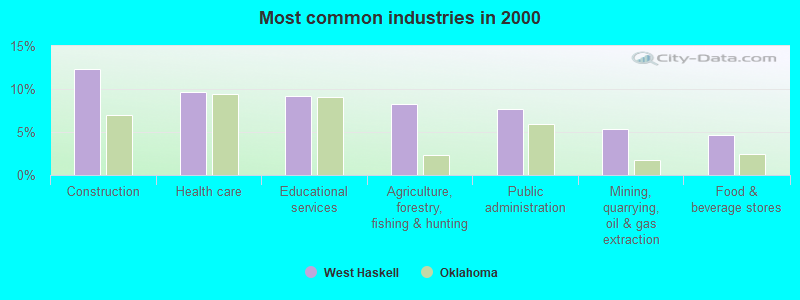
- Construction (12.3%)
- Health care (9.7%)
- Educational services (9.2%)
- Agriculture, forestry, fishing & hunting (8.2%)
- Public administration (7.7%)
- Mining, quarrying, oil & gas extraction (5.3%)
- Food & beverage stores (4.6%)
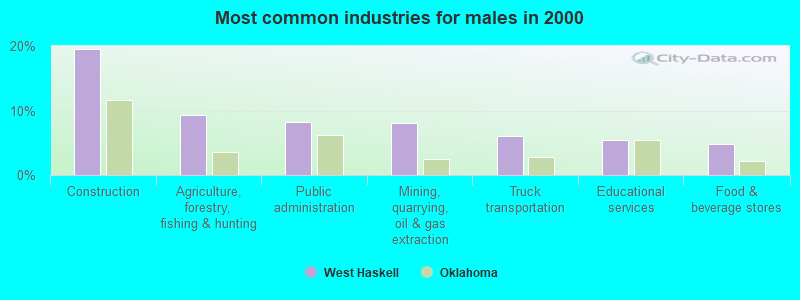
- Construction (19.5%)
- Agriculture, forestry, fishing & hunting (9.4%)
- Public administration (8.2%)
- Mining, quarrying, oil & gas extraction (8.1%)
- Truck transportation (6.0%)
- Educational services (5.5%)
- Food & beverage stores (4.8%)
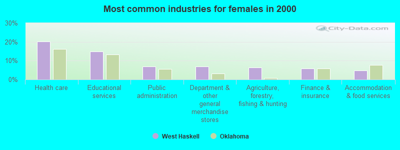
- Health care (20.3%)
- Educational services (14.8%)
- Public administration (6.9%)
- Department & other general merchandise stores (6.9%)
- Agriculture, forestry, fishing & hunting (6.5%)
- Finance & insurance (5.9%)
- Accommodation & food services (4.7%)
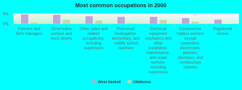
- Farmers and farm managers (5.8%)
- Driver/sales workers and truck drivers (5.6%)
- Other sales and related occupations, including supervisors (4.8%)
- Preschool, kindergarten, elementary, and middle school teachers (4.4%)
- Electrical equipment mechanics and other installation, maintenance, and repair workers, including supervisors (4.3%)
- Construction traders workers except carpenters, electricians, painters, plumbers, and construction laborers (3.6%)
- Registered nurses (2.7%)
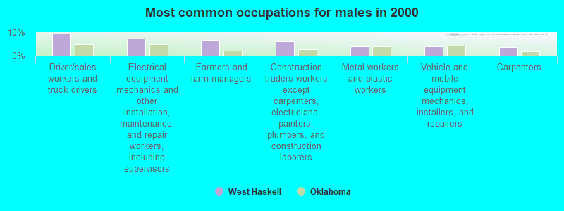
- Driver/sales workers and truck drivers (9.4%)
- Electrical equipment mechanics and other installation, maintenance, and repair workers, including supervisors (7.1%)
- Farmers and farm managers (6.8%)
- Construction traders workers except carpenters, electricians, painters, plumbers, and construction laborers (6.0%)
- Metal workers and plastic workers (4.0%)
- Vehicle and mobile equipment mechanics, installers, and repairers (4.0%)
- Carpenters (3.8%)
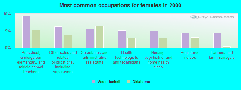
- Preschool, kindergarten, elementary, and middle school teachers (9.4%)
- Other sales and related occupations, including supervisors (6.3%)
- Secretaries and administrative assistants (5.5%)
- Health technologists and technicians (5.1%)
- Nursing, psychiatric, and home health aides (4.9%)
- Registered nurses (4.3%)
- Farmers and farm managers (4.3%)
Average climate in West Haskell, Oklahoma
Based on data reported by over 4,000 weather stations


Tornado activity:
West Haskell-area historical tornado activity is slightly below Oklahoma state average. It is 119% greater than the overall U.S. average.
On 3/26/1976, a category F5 (max. wind speeds 261-318 mph) tornado 33.0 miles away from the West Haskell place center killed 2 people and injured 64 people and caused between $500,000 and $5,000,000 in damages.
On 5/5/1960, a category F4 (max. wind speeds 207-260 mph) tornado 23.1 miles away from the place center killed 16 people and injured 106 people and caused between $500,000 and $5,000,000 in damages.
Earthquake activity:
West Haskell-area historical earthquake activity is significantly above Oklahoma state average. It is 681% greater than the overall U.S. average.On 11/6/2011 at 03:53:10, a magnitude 5.7 (5.7 MW, Depth: 3.2 mi, Class: Moderate, Intensity: VI - VII) earthquake occurred 86.4 miles away from West Haskell center
On 9/3/2016 at 12:02:44, a magnitude 5.8 (5.8 MW, Depth: 3.5 mi) earthquake occurred 124.7 miles away from West Haskell center
On 11/7/2016 at 01:44:24, a magnitude 5.0 (5.0 MW, Depth: 2.8 mi) earthquake occurred 101.0 miles away from the city center
On 11/5/2011 at 07:12:45, a magnitude 4.8 (4.8 MW, Depth: 1.9 mi, Class: Light, Intensity: IV - V) earthquake occurred 86.7 miles away from the city center
On 11/8/2011 at 02:46:57, a magnitude 4.8 (4.8 MW, Depth: 3.1 mi) earthquake occurred 87.7 miles away from the city center
On 9/6/1997 at 23:38:00, a magnitude 4.5 (4.5 LG, 4.2 LG, Depth: 3.1 mi) earthquake occurred 75.7 miles away from West Haskell center
Magnitude types: regional Lg-wave magnitude (LG), moment magnitude (MW)
Natural disasters:
The number of natural disasters in Haskell County (28) is a lot greater than the US average (15).Major Disasters (Presidential) Declared: 19
Emergencies Declared: 6
Causes of natural disasters: Floods: 15, Storms: 15, Winter Storms: 10, Tornadoes: 9, Winds: 2, Heavy Rain: 1, Hurricane: 1, Snow: 1, Other: 1 (Note: some incidents may be assigned to more than one category).
Hospitals and medical centers near West Haskell:
- QUINTON MANOR NURSING HOME (Nursing Home, about 9 miles away; QUINTON, OK)
- UNITED PARTNERS HEALTHCARE, INC (Home Health Center, about 9 miles away; STIGLER, OK)
- HASKELL COUNTY NURSING CENTER, INC (Nursing Home, about 10 miles away; STIGLER, OK)
- HASKELL COUNTY HOSPITAL (Hospital, about 10 miles away; STIGLER, OK)
- HEALTHBACK HOME HEALTH OF STIGLER (Home Health Center, about 10 miles away; STIGLER, OK)
- MID LAKES HOSPICE (Hospital, about 10 miles away; STIGLER, OK)
- SANS BOIS HEALTH SERVICES (Home Health Center, about 10 miles away; STIGLER, OK)
Colleges/universities with over 2000 students nearest to West Haskell:
- Carl Albert State College (about 39 miles; Poteau, OK; Full-time enrollment: 2,041)
- Oklahoma State University Institute of Technology (about 47 miles; Okmulgee, OK; FT enrollment: 3,243)
- Northeastern State University (about 52 miles; Tahlequah, OK; FT enrollment: 6,895)
- University of Arkansas-Fort Smith (about 53 miles; Fort Smith, AR; FT enrollment: 6,103)
- Oral Roberts University (about 70 miles; Tulsa, OK; FT enrollment: 3,216)
- Tulsa Community College (about 72 miles; Tulsa, OK; FT enrollment: 12,480)
- University of Tulsa (about 75 miles; Tulsa, OK; FT enrollment: 3,702)
Points of interest:
Notable locations in West Haskell: Brooken Volunteer Fire Department (A), Lona Valley Volunteer Fire Department (B), Kinta Fire Department (C), Hoyt Volunteer Fire Department (D), Whitefield Volunteer Fire Department (E). Display/hide their locations on the map
Churches in West Haskell include: Rocky Ridge Church (A), Oak Ridge Church (B), Fish Creek Church (C), Sandy Ridge Church (D), Jesus Name Church (E), West Liberty Church (F). Display/hide their locations on the map
Cemeteries: Enterprise Cemetery (1), Whitefield Cemetery (2), West Liberty Cemetery (3), Vance Cemetery (4), Hoyt Cemetery (5), Brooken Cemetery (6), Lewisville Cemetery (7). Display/hide their locations on the map
Reservoirs: Coblentz Lake (A), Eufaula Lake (B), Quinton Lake (C), Quinton City Lake (D), Kinta Lake (E). Display/hide their locations on the map
Streams, rivers, and creeks: Brooken Creek (A), Belle Starr Creek (B), Beaver Creek (C), Bear Creek (D), Andrew Creek (E), Chickasaw Creek (F), Russellville Branch (G), Camp Creek (H), Mountain Fork (I). Display/hide their locations on the map
| This place: | 2.4 people |
| Oklahoma: | 2.5 people |
| This place: | 71.4% |
| Whole state: | 66.8% |
| This place: | 3.7% |
| Whole state: | 5.9% |
Likely homosexual households (counted as self-reported same-sex unmarried-partner households)
- Lesbian couples: 0.2% of all households
- Gay men: 0.3% of all households
| This place: | 17.5% |
| Whole state: | 14.7% |
| This place: | 6.9% |
| Whole state: | 6.1% |
For population 15 years and over in West Haskell:
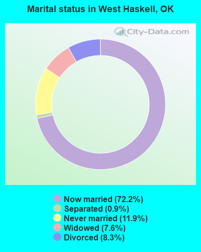
- Never married: 11.9%
- Now married: 72.2%
- Separated: 0.9%
- Widowed: 7.6%
- Divorced: 8.3%
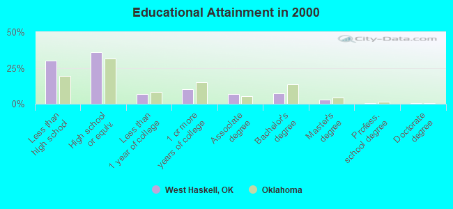
For population 25 years and over in West Haskell:
- High school or higher: 70.0%
- Bachelor's degree or higher: 10.8%
- Graduate or professional degree: 3.6%
- Unemployed: 3.8%
- Mean travel time to work (commute): 31.9 minutes
| Here: | 12.0 |
| Oklahoma average: | 11.7 |
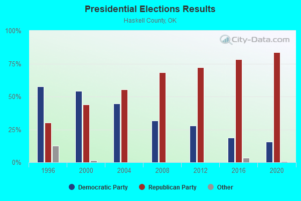
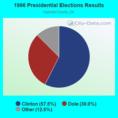
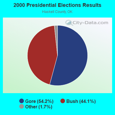
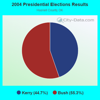
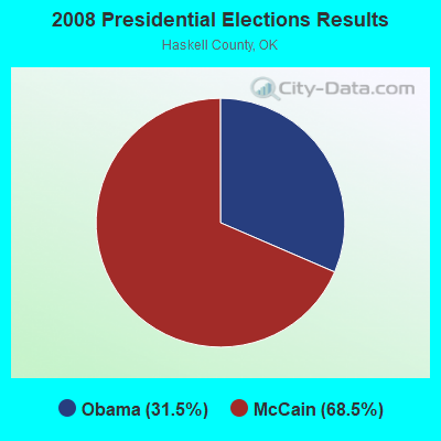
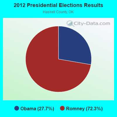
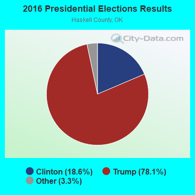
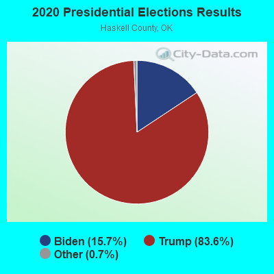
Graphs represent county-level data. Detailed 2008 Election Results
Religion statistics for West Haskell, OK (based on Haskell County data)
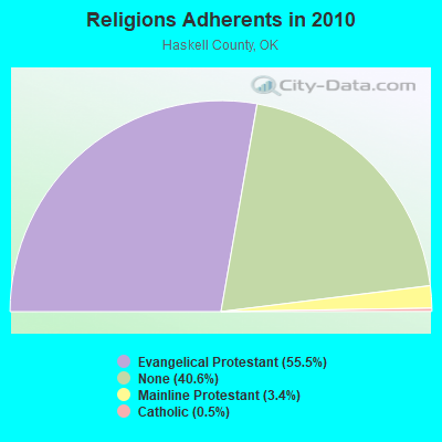
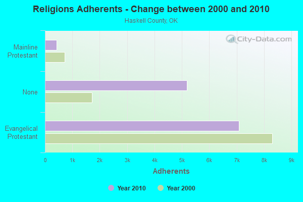
| Religion | Adherents | Congregations |
|---|---|---|
| Evangelical Protestant | 7,086 | 48 |
| Mainline Protestant | 431 | 4 |
| Catholic | 62 | 1 |
| Other | - | 1 |
| None | 5,190 | - |
Food Environment Statistics:
| Haskell County: | 1.66 / 10,000 pop. |
| State: | 1.97 / 10,000 pop. |
| Haskell County: | 1.66 / 10,000 pop. |
| Oklahoma: | 0.76 / 10,000 pop. |
| Haskell County: | 7.47 / 10,000 pop. |
| State: | 4.35 / 10,000 pop. |
| Haskell County: | 4.15 / 10,000 pop. |
| State: | 6.89 / 10,000 pop. |
| Haskell County: | 11.3% |
| Oklahoma: | 10.3% |
| Haskell County: | 31.3% |
| Oklahoma: | 29.2% |
Strongest AM radio stations in West Haskell:
- KRMG (740 AM; 50 kW; TULSA, OK; Owner: CXR HOLDINGS, INC.)
- KFAQ (1170 AM; 50 kW; TULSA, OK; Owner: JOURNAL BROADCAST CORPORATION)
- KTBZ (1430 AM; 25 kW; TULSA, OK; Owner: CLEAR CHANNEL BROADCASTING LICENSES, INC.)
- KYHN (1320 AM; 10 kW; FORT SMITH, AR; Owner: CAPSTAR TX LIMITED PARTNERSHIP)
- KMUS (1380 AM; 20 kW; MUSKOGEE, OK; Owner: ABC, INC.)
- KWHN (1650 AM; 10 kW; FT. SMITH, AR; Owner: CAPSTAR TX LIMITED PARTNERSHIP)
- KOMA (1520 AM; 50 kW; OKLAHOMA CITY, OK; Owner: RENDA BROADCASTING CORP. OF NEVADA)
- KGHT (880 AM; 50 kW; SHERIDAN, AR; Owner: METROPOLITAN RADIO GROUP, INC.)
- KEEL (710 AM; 50 kW; SHREVEPORT, LA; Owner: CITICASTERS LICENSES, L.P.)
- KRLD (1080 AM; 50 kW; DALLAS, TX; Owner: TEXAS INFINITY BROADCASTING L.P.)
- KAAY (1090 AM; 50 kW; LITTLE ROCK, AR; Owner: CITADEL BROADCASTING COMPANY)
- KFXR (1190 AM; 50 kW; DALLAS, TX; Owner: CLEAR CHANNEL BROADCASTING LICENSES, INC.)
- WBAP (820 AM; 50 kW; FORT WORTH, TX; Owner: WBAP-KSCS OPERATING, LTD.)
Strongest FM radio stations in West Haskell:
- KTKL (88.5 FM; STIGLER, OK; Owner: EDUCATIONAL MEDIA FOUNDATION)
- KMMY (97.1 FM; MUSKOGEE, OK; Owner: KMMY, Inc.)
- KZBB (97.9 FM; POTEAU, OK; Owner: CAPSTAR TX LIMITED PARTNERSHIP)
- KMAG (99.1 FM; FORT SMITH, AR; Owner: CAPSTAR TX LIMITED PARTNERSHIP)
- KTCS-FM (99.9 FM; FORT SMITH, AR; Owner: BIG CHIEF BROADCASTING COMPANY)
- K204EW (88.7 FM; POTEAU, OK; Owner: CALVARY CHAPEL OF TWIN FALLS, INC.)
- K219CN (91.7 FM; POTEAU, OK; Owner: AMERICAN FAMILY ASSOCIATION)
- KARG (91.7 FM; POTEAU, OK; Owner: AMERICAN FAMILY ASSOCIATION)
- KTNT (102.5 FM; EUFAULA, OK; Owner: K95.5, INC.)
- KOMS (107.3 FM; POTEAU, OK; Owner: CUMULUS LICENSING CORP.)
- KESC (103.7 FM; WILBURTON, OK; Owner: LITTLE DIXIE RADIO, INC)
- KMCO (101.3 FM; MCALESTER, OK; Owner: LITTLE DIXIE RADIO, INC.)
- KBCW (91.9 FM; MCALESTER, OK; Owner: THE UNIVERSITY OF CENTRAL OKLAHOMA)
TV broadcast stations around West Haskell:
- KOET (Channel 3; EUFAULA, OK; Owner: OKLAHOMA EDUCATIONAL TELEVISION AUTHORITY)
- KTUL (Channel 8; TULSA, OK; Owner: KTUL, LLC)
- KOTV (Channel 6; TULSA, OK; Owner: GRIFFIN LICENSING, L.L.C.)
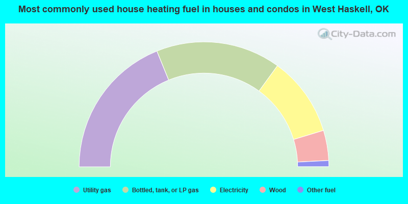
- 37.7%Utility gas
- 32.3%Bottled, tank, or LP gas
- 20.6%Electricity
- 7.8%Wood
- 1.6%Other fuel
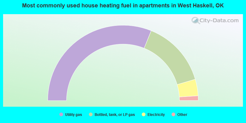
- 62.2%Utility gas
- 28.6%Bottled, tank, or LP gas
- 7.1%Electricity
- 1.0%Other fuel
- 1.0%No fuel used
West Haskell compared to Oklahoma state average:
- Unemployed percentage significantly below state average.
- Black race population percentage significantly below state average.
- Hispanic race population percentage significantly below state average.
- Median age above state average.
- Foreign-born population percentage significantly below state average.
- Renting percentage below state average.
- Length of stay since moving in significantly above state average.
- Number of rooms per house significantly below state average.
- House age significantly below state average.
- Number of college students below state average.
- Percentage of population with a bachelor's degree or higher below state average.