West Daggett, Utah
Submit your own pictures of this place and show them to the world
- OSM Map
- General Map
- Google Map
- MSN Map

| Males: 421 | |
| Females: 331 |
| Median resident age: | 39.4 years |
| Utah median age: | 27.1 years |
Zip code: 84046
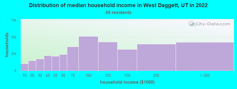
| West Daggett: | $58,479 |
| UT: | $89,168 |
Estimated per capita income in 2022: $27,244 (it was $14,901 in 2000)
West Daggett CCD income, earnings, and wages data
Estimated median house or condo value in 2022: $313,054 (it was $70,700 in 2000)
| West Daggett: | $313,054 |
| UT: | $499,500 |
Mean prices in 2022: all housing units: $325,669; detached houses: $401,539; mobile homes: $151,518
Detailed information about poverty and poor residents in West Daggett, UT
Compare current foreclosures near your location:
| Photo | Address | Area | Beds / Baths | Price | Details |
|---|---|---|---|---|---|

|
#1
S High St
Columbus, OH 43207
|
1,678 sq. feet
|
2 baths 4 beds |
$27,500
|
show details |

|
#2
Bayberry Cir
Columbus, OH 43207
|
1,564 sq. feet
|
1 baths 3 beds |
$127,500
|
show details |

|
#3
E 21st Ave
Columbus, OH 43211
|
1,061 sq. feet
|
1 baths 3 beds |
$179,900
|
show details |

|
#4
Rockwell Rd
Columbus, OH 43207
|
1,900 sq. feet
|
2 baths 4 beds |
show details | |

|
#5
Grove Cir
Columbus, OH 43230
|
1,236 sq. feet
|
2 baths 2 beds |
show details | |

|
#6
Rohr Rd
Groveport, OH 43125
|
1,212 sq. feet
|
1 baths 3 beds |
show details | |

|
#7
Oak Rd
Columbus, OH 43217
|
1,243 sq. feet
|
2 baths 3 beds |
show details | |

|
#8
Legend
Columbus, OH 43230
|
2,100 sq. feet
|
3 baths 3 beds |
show details | |

|
#9
Thrailkill Rd
Grove City, OH 43123
|
1,670 sq. feet
|
1 baths 4 beds |
show details | |

|
#10
Basswood Rd
Columbus, OH 43207
|
910 sq. feet
|
1 baths 2 beds |
show details |
| Photo | Address | Area | Beds / Baths | Price | Details |
|---|---|---|---|---|---|

|
#11
S 8th St
Columbus, OH 43207
|
1,053 sq. feet
|
1 baths 3 beds |
show details | |

|
#12
Troutbrook Dr
Dublin, OH 43017
|
2,628 sq. feet
|
3 baths 3 beds |
show details | |

|
#13
Corbins Mill Dr
Dublin, OH 43017
|
1,330 sq. feet
|
2 baths 2 beds |
show details | |

|
#14
Linview Ave
Columbus, OH 43211
|
1,085 sq. feet
|
1 baths 2 beds |
show details | |

|
#15
Scott St
Columbus, OH 43222
|
1,920 sq. feet
|
2 baths 5 beds |
show details | |

|
#16
Slaton Ct
Columbus, OH 43235
|
1,024 sq. feet
|
2 baths 2 beds |
show details | |

|
#17
Village Park Dr
Columbus, OH 43228
|
1,345 sq. feet
|
2 baths 3 beds |
show details | |

|
#18
Bluebird Ct
Westerville, OH 43081
|
976 sq. feet
|
2 baths 3 beds |
show details | |

|
#19
E Mound St
Columbus, OH 43209
|
1,665 sq. feet
|
2 baths 4 beds |
show details | |

|
#20
Eminence Ln
Grove City, OH 43123
|
1,704 sq. feet
|
3 baths 4 beds |
show details |
| Photo | Address | Area | Beds / Baths | Price | Details |
|---|---|---|---|---|---|

|
#21
Arklow Way
Canal Winchester, OH 43110
|
980 sq. feet
|
2 baths 2 beds |
show details | |

|
#22
Gilman Rd
Columbus, OH 43228
|
1,142 sq. feet
|
3 baths 3 beds |
show details | |

|
#23
Ashby Rd
Columbus, OH 43209
|
1,129 sq. feet
|
2 baths 3 beds |
show details | |

|
#24
Passage Creek Dr
Dublin, OH 43016
|
1,504 sq. feet
|
3 baths 2 beds |
show details | |

|
#25
Boston Harbor Way
Orient, OH 43146
|
1,300 sq. feet
|
3 baths 2 beds |
show details | |

|
#26
Floribunda Dr
Columbus, OH 43209
|
1,604 sq. feet
|
2 baths 3 beds |
show details | |

|
#27
Cleggan St
Canal Winchester, OH 43110
|
1,356 sq. feet
|
3 baths 3 beds |
show details | |

|
#28
Melrose Ave
Columbus, OH 43211
|
1,488 sq. feet
|
1 baths 4 beds |
show details | |

|
#29
Karikal Dr
Westerville, OH 43081
|
1,260 sq. feet
|
2 baths 3 beds |
show details | |

|
#30
Rohr Rd
Groveport, OH 43125
|
1,926 sq. feet
|
3 baths 3 beds |
show details |
| Photo | Address | Area | Beds / Baths | Price | Details |
|---|---|---|---|---|---|

|
#31
Rhoads Ave
Columbus, OH 43207
|
1,030 sq. feet
|
1 baths 3 beds |
show details | |

|
#32
Lewis Rd
Columbus, OH 43207
|
1,976 sq. feet
|
2 baths 4 beds |
show details | |

|
#33
Battalion Pl
Galloway, OH 43119
|
1,552 sq. feet
|
2 baths 3 beds |
show details | |

|
#34
Maize Rd
Columbus, OH 43224
|
1,678 sq. feet
|
2 baths 3 beds |
show details | |

|
#35
Oakland Park Ave
Columbus, OH 43224
|
1,127 sq. feet
|
1 baths 3 beds |
show details | |

|
#36
E Livingston Ave
Reynoldsburg, OH 43068
|
1,404 sq. feet
|
2 baths 4 beds |
show details | |

|
#37
Golden Cloud Ln
Columbus, OH 43228
|
1,576 sq. feet
|
3 baths 3 beds |
show details | |

|
#38
Blendon Grove Way
Columbus, OH 43230
|
976 sq. feet
|
3 baths 2 beds |
show details | |

|
#39
San Miguel Pl
Reynoldsburg, OH 43068
|
1,024 sq. feet
|
2 baths 2 beds |
show details | |

|
#40
Meadowleigh Way
Columbus, OH 43230
|
976 sq. feet
|
3 baths 2 beds |
show details |
| Photo | Address | Area | Beds / Baths | Price | Details |
|---|---|---|---|---|---|

|
#41
Blendon Point Dr
Columbus, OH 43230
|
896 sq. feet
|
2 baths 2 beds |
show details | |

|
#42
Clement Dr
Columbus, OH 43085
|
1,078 sq. feet
|
2 baths 3 beds |
show details | |

|
#43
Oldenburgh Way
Dublin, OH 43016
|
1,566 sq. feet
|
3 baths 3 beds |
show details | |

|
#44
Lieutenant Dr
Galloway, OH 43119
|
1,848 sq. feet
|
3 baths 3 beds |
show details | |

|
#45
Sandrell Dr
Columbus, OH 43228
|
1,132 sq. feet
|
2 baths 3 beds |
show details | |

|
#46
Alderson Ct
Columbus, OH 43228
|
1,224 sq. feet
|
3 baths 3 beds |
show details | |

|
#47
Brentwood Rd
Columbus, OH 43209
|
3,716 sq. feet
|
4 baths 4 beds |
show details | |

|
#48
Meadowsview Ln
Hilliard, OH 43026
|
2,972 sq. feet
|
4 baths 4 beds |
show details | |

|
#49
Holly River Ave
Dublin, OH 43016
|
1,335 sq. feet
|
3 baths 2 beds |
show details | |

|
Check over 1 million property listings on Foreclosure.com!
|
browse all offers | |||

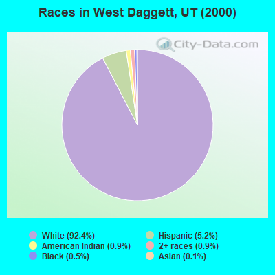
- 71392.4%White alone
- 405.2%Hispanic
- 70.9%American Indian alone
- 70.9%Two or more races
- 40.5%Black alone
- 10.1%Asian alone
Races in West Daggett detailed stats: ancestries, foreign born residents, place of birth
 Recent articles from our blog. Our writers, many of them Ph.D. graduates or candidates, create easy-to-read articles on a wide variety of topics.
Current Local Time: MST time zone
Land area: 371.8 square miles.
Population density: 2.0 people per square mile (very low).

| West Daggett CCD: | 0.4% ($292) |
| Utah: | 0.7% ($956) |
Nearest city with pop. 50,000+: Provo, UT  (112.2 miles , pop. 105,166).
Nearest city with pop. 200,000+: Northeast Jefferson, CO (257.6 miles , pop. 450,166).
Nearest city with pop. 1,000,000+: Phoenix, AZ (528.9 miles , pop. 1,321,045).
Nearest cities:
Latitude: 40.94 N, Longitude: 109.73 W
Area code commonly used in this area: 435

| Here: | 4.8% |
| Utah: | 2.5% |
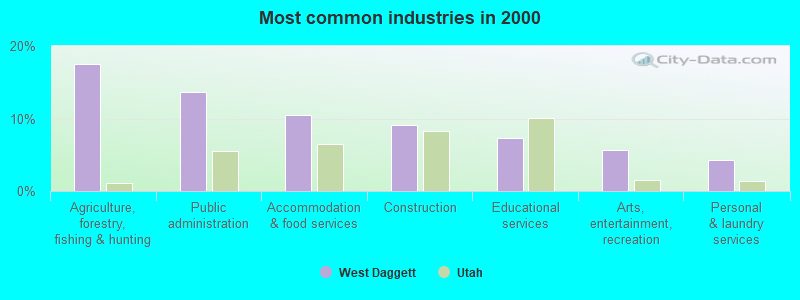
- Agriculture, forestry, fishing & hunting (17.5%)
- Public administration (13.7%)
- Accommodation & food services (10.5%)
- Construction (9.1%)
- Educational services (7.4%)
- Arts, entertainment, recreation (5.6%)
- Personal & laundry services (4.2%)
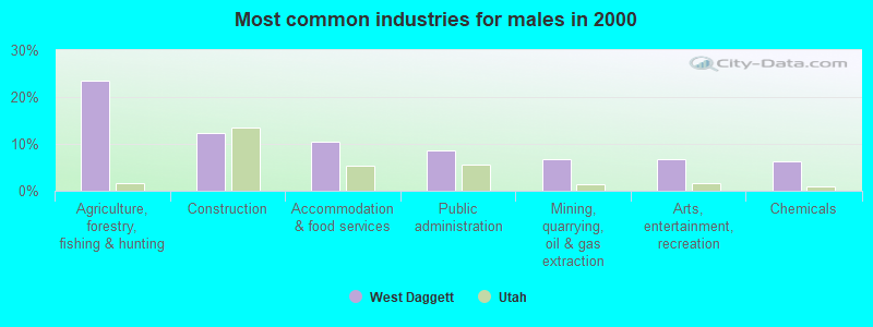
- Agriculture, forestry, fishing & hunting (23.5%)
- Construction (12.3%)
- Accommodation & food services (10.5%)
- Public administration (8.6%)
- Mining, quarrying, oil & gas extraction (6.8%)
- Arts, entertainment, recreation (6.8%)
- Chemicals (6.2%)
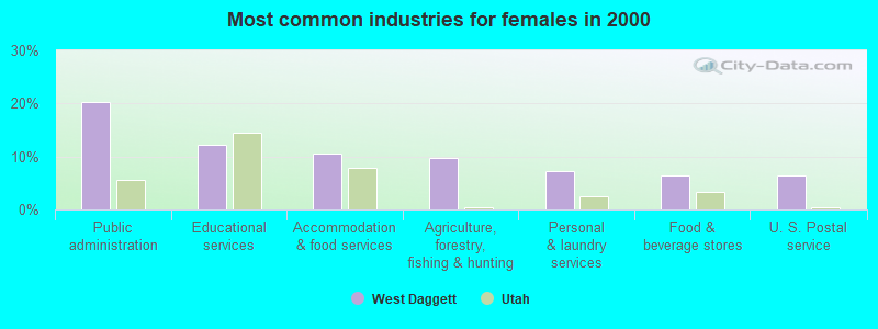
- Public administration (20.3%)
- Educational services (12.2%)
- Accommodation & food services (10.6%)
- Agriculture, forestry, fishing & hunting (9.8%)
- Personal & laundry services (7.3%)
- Food & beverage stores (6.5%)
- U. S. Postal service (6.5%)
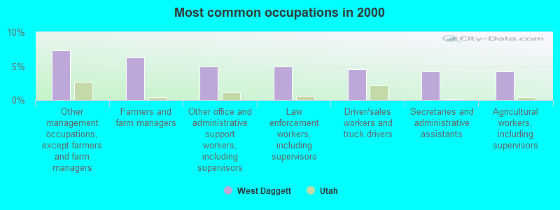
- Other management occupations, except farmers and farm managers (7.4%)
- Farmers and farm managers (6.3%)
- Other office and administrative support workers, including supervisors (4.9%)
- Law enforcement workers, including supervisors (4.9%)
- Driver/sales workers and truck drivers (4.6%)
- Secretaries and administrative assistants (4.2%)
- Agricultural workers, including supervisors (4.2%)
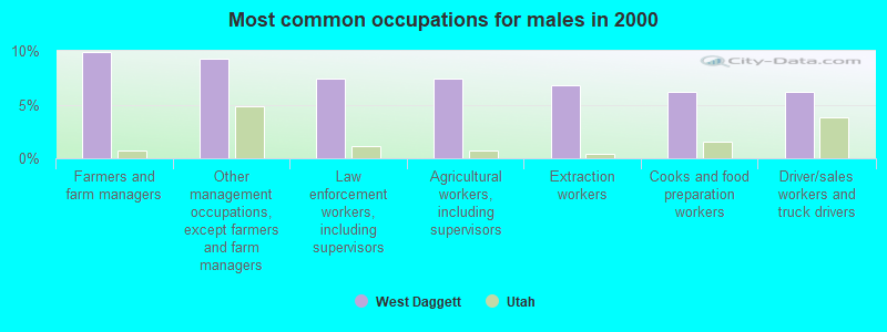
- Farmers and farm managers (9.9%)
- Other management occupations, except farmers and farm managers (9.3%)
- Law enforcement workers, including supervisors (7.4%)
- Agricultural workers, including supervisors (7.4%)
- Extraction workers (6.8%)
- Cooks and food preparation workers (6.2%)
- Driver/sales workers and truck drivers (6.2%)
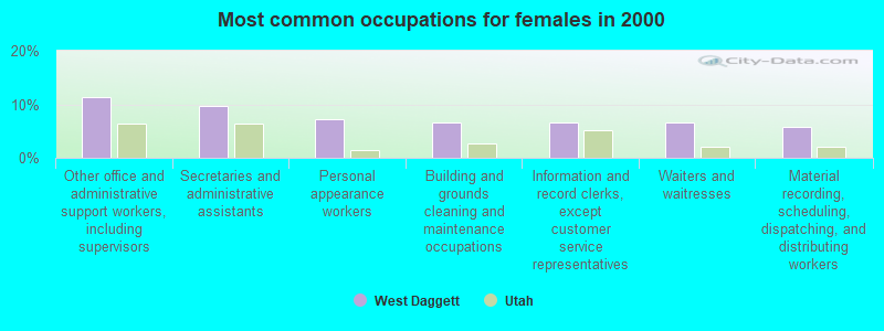
- Other office and administrative support workers, including supervisors (11.4%)
- Secretaries and administrative assistants (9.8%)
- Personal appearance workers (7.3%)
- Building and grounds cleaning and maintenance occupations (6.5%)
- Information and record clerks, except customer service representatives (6.5%)
- Waiters and waitresses (6.5%)
- Material recording, scheduling, dispatching, and distributing workers (5.7%)
Average climate in West Daggett, Utah
Based on data reported by over 4,000 weather stations


(lower is better)
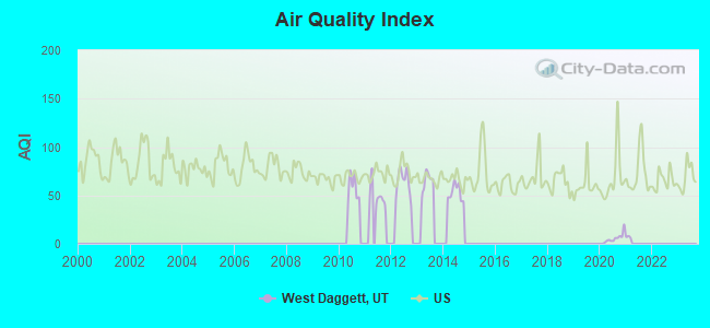
Air Quality Index (AQI) level in 2020 was 6.26. This is significantly better than average.
| City: | 6.26 |
| U.S.: | 72.56 |
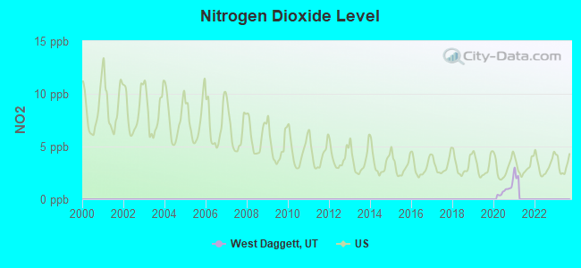
Nitrogen Dioxide (NO2) [ppb] level in 2020 was 0.864. This is significantly better than average. Closest monitor was 12.0 miles away from the city center.
| City: | 0.864 |
| U.S.: | 5.109 |
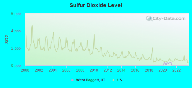
Sulfur Dioxide (SO2) [ppb] level in 2020 was 0.242. This is significantly better than average. Closest monitor was 12.0 miles away from the city center.
| City: | 0.242 |
| U.S.: | 1.515 |
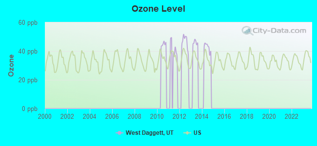
Ozone [ppb] level in 2014 was 42.7. This is worse than average. Closest monitor was 18.0 miles away from the city center.
| City: | 42.7 |
| U.S.: | 33.3 |
Earthquake activity:
West Daggett-area historical earthquake activity is significantly above Utah state average. It is 1555% greater than the overall U.S. average.On 8/18/1959 at 06:37:13, a magnitude 7.7 (7.7 UK, Class: Major, Intensity: VIII - XII) earthquake occurred 254.8 miles away from West Daggett center, causing $26,000,000 total damage
On 10/28/1983 at 14:06:06, a magnitude 7.3 (6.2 MB, 7.3 MS, 7.0 MW) earthquake occurred 299.8 miles away from the city center, causing 2 deaths (2 shaking deaths) and 3 injuries, causing $15,000,000 total damage
On 10/3/1915 at 06:52:48, a magnitude 7.6 (7.6 UK) earthquake occurred 408.1 miles away from West Daggett center
On 3/28/1975 at 02:31:05, a magnitude 6.2 (6.1 MB, 6.0 MS, 6.2 ML, Class: Strong, Intensity: VII - IX) earthquake occurred 160.0 miles away from the city center
On 2/3/1994 at 09:05:04, a magnitude 5.8 (5.4 MB, 5.5 MS, 5.8 MW, 5.8 ML, Depth: 4.9 mi, Class: Moderate, Intensity: VI - VII) earthquake occurred 141.7 miles away from West Daggett center
On 3/18/2020 at 13:09:31, a magnitude 5.7 (5.7 MW, Depth: 7.4 mi) earthquake occurred 123.3 miles away from the city center
Magnitude types: body-wave magnitude (MB), local magnitude (ML), surface-wave magnitude (MS), moment magnitude (MW)
Natural disasters:
The number of natural disasters in Daggett County (6) is a lot smaller than the US average (15).Major Disasters (Presidential) Declared: 2
Emergencies Declared: 2
Causes of natural disasters: Floods: 2, Drought: 1, Fire: 1, Hurricane: 1, Landslide: 1, Storm: 1, Other: 1 (Note: some incidents may be assigned to more than one category).
Colleges/universities with over 2000 students nearest to West Daggett:
- Western Wyoming Community College (about 52 miles; Rock Springs, WY; Full-time enrollment: 2,086)
- University of Utah (about 112 miles; Salt Lake City, UT; FT enrollment: 28,454)
- Brigham Young University-Provo (about 112 miles; Provo, UT; FT enrollment: 33,525)
- Westminster College (about 112 miles; Salt Lake City, UT; FT enrollment: 2,870)
- Western Governors University (about 114 miles; Salt Lake City, UT; FT enrollment: 31,481)
- Utah Valley University (about 114 miles; Orem, UT; FT enrollment: 24,403)
- Latter-day Saints Business College (about 114 miles; Salt Lake City, UT; FT enrollment: 2,059)
Points of interest:
Notable locations in West Daggett: Summit Springs Guard Station (A), Sheep Creek Bay Campground (B), Red Spring Campground (C), Lucerne Valley Campground (D), Kingfisher Island Campground (E), Dutch John Draw Campground (F), Dutch John Boat Ramp (G), Brown Lake Campground (H), Antelope Flat Campground (I), Jarvies Canyon Boat Camp (J), Skull Creek Campground (K), Greens Lakes Campground (L), Greendale Campground (M), Red Canyon Picnic Area (N), Red Canyon Overlook (O), Red Canyon Visitor Center (P), Red Canyon Lodge (Q), Moenkopi Campground (R), Mustang Ridge Campground (S), Manila Ranger Station (T). Display/hide their locations on the map
Church in West Daggett: The Church of Jesus Christ of Latter Day Saints (A). Display/hide its location on the map
Cemeteries: Dowds Grave (1), Manila Cemetery (2). Display/hide their locations on the map
Lakes and reservoirs: Lamb Lakes (A), Tepee Lakes (B), Weyman Lakes (C), Red Lake (D), Dowds Hole (E), Potter Lake (F), Spirit Lake (G), Anson Lake (H). Display/hide their locations on the map
Streams, rivers, and creeks: Trail Creek (A), Sheep Creek (B), Dowd Creek (C), Francis Creek (D), Spring Creek (E), Spruce Creek (F), Hope Creek (G), Honslinger Creek (H), Allen Creek (I). Display/hide their locations on the map
Parks in West Daggett include: Navajo Cliffs Picnic Area (1), Lucerne Point Group Site (2), Old Carter Trail Historical marker (3), Sweet Ranch National Historic Site (4), Palisades Memorial Park (5). Display/hide their locations on the map
| This place: | 2.3 people |
| Utah: | 3.1 people |
| This place: | 68.3% |
| Whole state: | 75.2% |
| This place: | 3.9% |
| Whole state: | 4.6% |
Likely homosexual households (counted as self-reported same-sex unmarried-partner households)
- Lesbian couples: 0.0% of all households
- Gay men: 0.3% of all households
| This place: | 6.4% |
| Whole state: | 9.4% |
| This place: | 2.8% |
| Whole state: | 3.9% |
77 people in local jails and other confinement facilities (including police lockups) in 2000
For population 15 years and over in West Daggett:
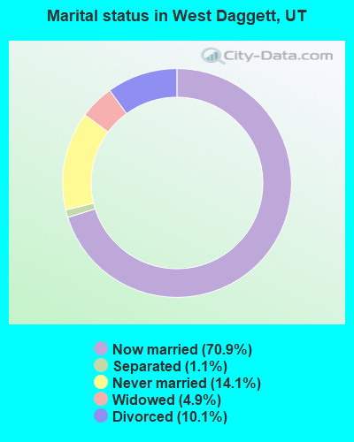
- Never married: 14.1%
- Now married: 70.9%
- Separated: 1.1%
- Widowed: 4.9%
- Divorced: 10.1%
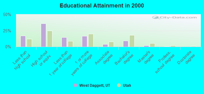
For population 25 years and over in West Daggett:
- High school or higher: 82.8%
- Bachelor's degree or higher: 11.5%
- Graduate or professional degree: 2.3%
- Unemployed: 7.5%
- Mean travel time to work (commute): 21.1 minutes
| Here: | 8.5 |
| Utah average: | 10.5 |
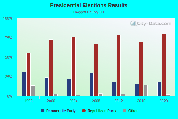
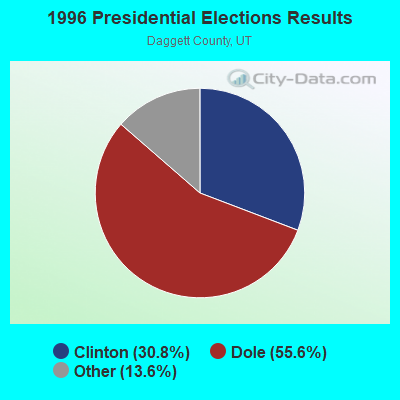
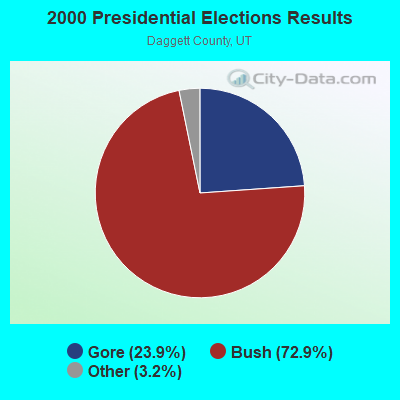
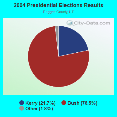
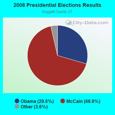
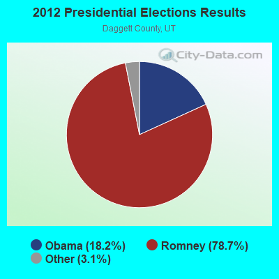
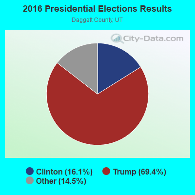
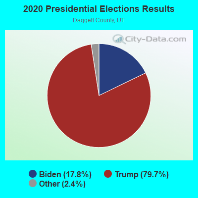
Graphs represent county-level data. Detailed 2008 Election Results
Religion statistics for West Daggett, UT (based on Daggett County data)
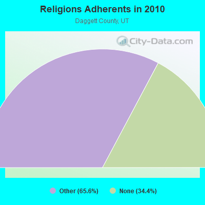
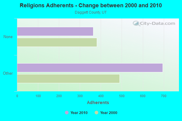
| Religion | Adherents | Congregations |
|---|---|---|
| Other | 695 | 3 |
| None | 364 | - |
Food Environment Statistics:
| This county: | 10.85 / 10,000 pop. |
| Utah: | 1.37 / 10,000 pop. |
| This county: | 10.85 / 10,000 pop. |
| Utah: | 2.82 / 10,000 pop. |
| Daggett County: | 21.69 / 10,000 pop. |
| Utah: | 5.09 / 10,000 pop. |
| This county: | 8.4% |
| Utah: | 6.3% |
| Daggett County: | 24.5% |
| Utah: | 23.6% |
Strongest AM radio stations in West Daggett:
- KALL (700 AM; 50 kW; NORTH SALT LAKE CITY, UT; Owner: CITICASTERS LICENSES, L.P.)
- KVEL (920 AM; 5 kW; VERNAL, UT; Owner: ASHLEY COMMUNICATIONS, INC.)
- KIQN (1010 AM; 50 kW; TOOELE, UT)
- KSL (1160 AM; 50 kW; SALT LAKE CITY, UT; Owner: BONNEVILLE HOLDING COMPANY)
- KNZZ (1100 AM; 50 kW; GRAND JUNCTION, CO; Owner: M B C GRAND BROADCASTING, INC.)
- KNEU (1250 AM; 5 kW; ROOSEVELT, UT; Owner: COUNTRY GOLD BROADCASTING, INC.)
- KRKK (1360 AM; 5 kW; ROCK SPRINGS, WY; Owner: BIG THICKET B/CING CO. OF WY, INC.)
- KTKK (630 AM; 10 kW; SANDY, UT; Owner: UNITED BROADCASTING COMPANY)
- KOAL (750 AM; 10 kW; PRICE, UT; Owner: EASTERN UTAH BROADCASTING CO.)
- KMER (950 AM; 5 kW; KEMMERER, WY; Owner: CHAPARRAL BROADCASTING, INC.)
- KTWO (1030 AM; 50 kW; CASPER, WY; Owner: CITICASTERS LICENSES, L.P.)
- KLTT (670 AM; 50 kW; COMMERCE CITY, CO; Owner: KLZ RADIO, INC.)
- KKZN (760 AM; 50 kW; THORNTON, CO; Owner: JACOR BROADCASTING OF COLORADO, INC.)
Strongest FM radio stations in West Daggett:
- KIFX (98.5 FM; ROOSEVELT, UT; Owner: EVANS BROADCASTING, INC.)
- KXRQ (94.3 FM; ROOSEVELT, UT; Owner: UINTA BROADCASTING, L.C.)
- KLCY-FM (105.9 FM; VERNAL, UT; Owner: ASHLEY COMMUNICATIONS, INC.)
- K224CI (92.7 FM; LYMAN, WY; Owner: WESTERN INSPIRATIONAL BROADCASTERS)
- KSIT (104.5 FM; ROCK SPRINGS, WY; Owner: BIG TICKET BROADCASTING COMPANY OF W)
- KQSW (96.5 FM; ROCK SPRINGS, WY; Owner: BIG THICKET BROADCASTING CO OF WY)
- KUWZ (90.5 FM; ROCK SPRINGS, WY; Owner: UNIVERSITY OF WYOMING)
- KYCS (95.1 FM; ROCK SPRINGS, WY; Owner: FAITH BROADCASTING CORPORATION)
- KFRZ (92.1 FM; GREEN RIVER, WY; Owner: WAGONWHEEL COMMUNICATIONS CORP)
TV broadcast stations around West Daggett:
- K25EE (Channel 25; MOUNTAIN VIEW, ETC., UT; Owner: DAGGETT COUNTY TELEVISION DEPT.)

- 64.6%Bottled, tank, or LP gas
- 20.6%Wood
- 10.5%Electricity
- 4.3%Utility gas
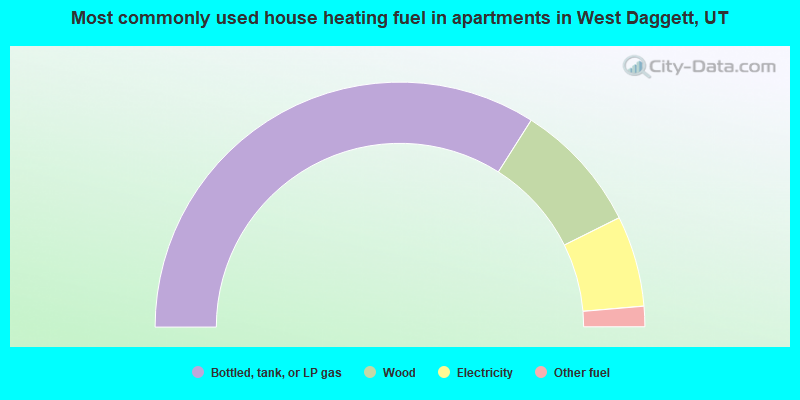
- 68.0%Bottled, tank, or LP gas
- 17.3%Wood
- 12.0%Electricity
- 2.7%Other fuel
West Daggett compared to Utah state average:
- Median household income below state average.
- Median house value below state average.
- Hispanic race population percentage significantly below state average.
- Median age significantly above state average.
- Foreign-born population percentage significantly below state average.
- Length of stay since moving in significantly above state average.
- Number of rooms per house significantly below state average.
- House age significantly below state average.
- Institutionalized population percentage significantly above state average.
- Number of college students significantly below state average.
- Percentage of population with a bachelor's degree or higher below state average.