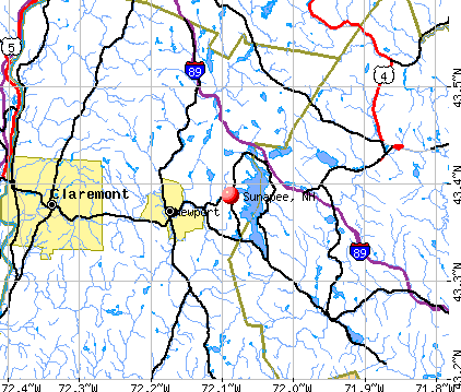
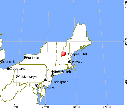
Sunapee, New Hampshire

Sunapee: Ice storm Sunapee 09
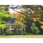
Sunapee: Bright autumn color, Sunapee NH
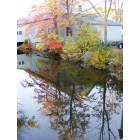
Sunapee: Mornin stroll in Sunapee.
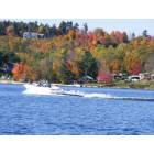
Sunapee: A wonderous fall day in Sunapee
- add
your
Submit your own pictures of this town and show them to the world
- OSM Map
- General Map
- Google Map
- MSN Map
Population change since 2000: +10.1%
 |
| Males: 1,666 | |
| Females: 1,699 |
| Median resident age: | 46.2 years |
| New Hampshire median age: | 43.9 years |
Zip codes: 03782.
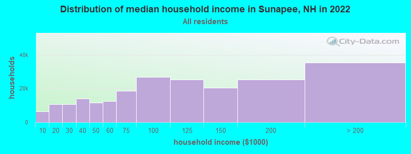
| Sunapee: | $84,538 |
| NH: | $89,992 |
Estimated per capita income in 2022: $54,650 (it was $29,184 in 2000)
Sunapee town income, earnings, and wages data
Estimated median house or condo value in 2022: $368,607 (it was $136,900 in 2000)
| Sunapee: | $368,607 |
| NH: | $384,700 |
Mean prices in 2022: all housing units: $337,766; detached houses: $372,023; townhouses or other attached units: $454,943; in 2-unit structures: $245,522; in 3-to-4-unit structures: $240,260; in 5-or-more-unit structures: $222,243; mobile homes: $88,713
Detailed information about poverty and poor residents in Sunapee, NH


- 3,26196.9%White alone
- 351.0%Two or more races
- 260.8%Hispanic
- 190.6%Asian alone
- 110.3%American Indian alone
- 60.2%Black alone
- 60.2%Other race alone
- 10.03%Native Hawaiian and Other
Pacific Islander alone

Races in Sunapee detailed stats: ancestries, foreign born residents, place of birth
According to our research of New Hampshire and other state lists, there was 1 registered sex offender living in Sunapee, New Hampshire as of June 07, 2024.
The ratio of all residents to sex offenders in Sunapee is 3,365 to 1.
The ratio of registered sex offenders to all residents in this city is much lower than the state average.
Type |
2009 |
2010 |
2011 |
2012 |
2013 |
2014 |
2015 |
2016 |
2017 |
2018 |
2019 |
2020 |
2021 |
2022 |
|---|---|---|---|---|---|---|---|---|---|---|---|---|---|---|
| Murders (per 100,000) | 0 (0.0) | 0 (0.0) | 0 (0.0) | 0 (0.0) | 0 (0.0) | 0 (0.0) | 0 (0.0) | 0 (0.0) | 0 (0.0) | 0 (0.0) | 0 (0.0) | 0 (0.0) | 0 (0.0) | 0 (0.0) |
| Rapes (per 100,000) | 0 (0.0) | 1 (29.7) | 1 (29.7) | 0 (0.0) | 3 (90.1) | 0 (0.0) | 0 (0.0) | 0 (0.0) | 1 (29.0) | 0 (0.0) | 0 (0.0) | 2 (57.1) | 1 (28.4) | 1 (28.9) |
| Robberies (per 100,000) | 0 (0.0) | 0 (0.0) | 0 (0.0) | 0 (0.0) | 0 (0.0) | 0 (0.0) | 1 (29.6) | 0 (0.0) | 0 (0.0) | 0 (0.0) | 0 (0.0) | 1 (28.6) | 0 (0.0) | 0 (0.0) |
| Assaults (per 100,000) | 2 (58.9) | 0 (0.0) | 0 (0.0) | 1 (29.9) | 3 (90.1) | 4 (119.5) | 1 (29.6) | 0 (0.0) | 2 (58.0) | 1 (28.9) | 0 (0.0) | 0 (0.0) | 3 (85.3) | 0 (0.0) |
| Burglaries (per 100,000) | 1 (29.4) | 1 (29.7) | 5 (148.4) | 16 (477.8) | 4 (120.1) | 6 (179.3) | 3 (88.9) | 4 (117.4) | 3 (87.0) | 0 (0.0) | 1 (28.7) | 1 (28.6) | 1 (28.4) | 2 (57.9) |
| Thefts (per 100,000) | 1 (29.4) | 5 (148.6) | 11 (326.5) | 28 (836.1) | 15 (450.5) | 15 (448.3) | 13 (385.2) | 8 (234.7) | 15 (434.9) | 15 (433.3) | 16 (458.6) | 20 (571.3) | 18 (511.5) | 15 (433.9) |
| Auto thefts (per 100,000) | 0 (0.0) | 1 (29.7) | 0 (0.0) | 0 (0.0) | 0 (0.0) | 0 (0.0) | 1 (29.6) | 0 (0.0) | 1 (29.0) | 0 (0.0) | 2 (57.3) | 0 (0.0) | 1 (28.4) | 0 (0.0) |
| Arson (per 100,000) | 0 (0.0) | 0 (0.0) | 0 (0.0) | 1 (29.9) | 0 (0.0) | 0 (0.0) | 0 (0.0) | 0 (0.0) | 0 (0.0) | 0 (0.0) | 1 (28.7) | 0 (0.0) | 0 (0.0) | 1 (28.9) |
| City-Data.com crime index | 15.0 | 34.2 | 47.2 | 72.9 | 116.5 | 54.4 | 38.8 | 17.6 | 60.6 | 23.1 | 24.9 | 79.1 | 64.5 | 44.5 |
The City-Data.com crime index weighs serious crimes and violent crimes more heavily. Higher means more crime, U.S. average is 246.1. It adjusts for the number of visitors and daily workers commuting into cities.
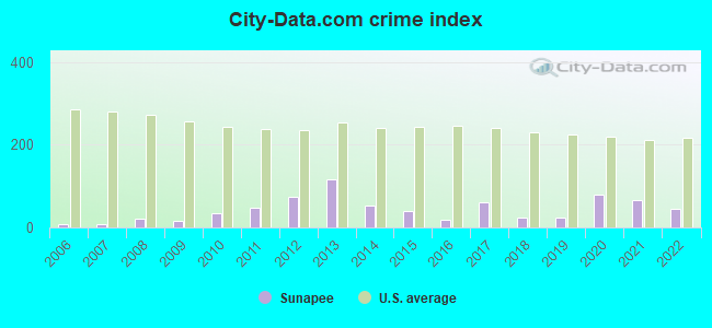
Crime rate in Sunapee detailed stats: murders, rapes, robberies, assaults, burglaries, thefts, arson
Full-time law enforcement employees in 2021, including police officers: 6 (5 officers - 5 male; 0 female).
| Officers per 1,000 residents here: | 1.42 |
| New Hampshire average: | 2.14 |
 Recent articles from our blog. Our writers, many of them Ph.D. graduates or candidates, create easy-to-read articles on a wide variety of topics.

 | Lake Sunapee area high HOA fees (25 replies) |
| $4,400 apartment rental in Lebanon, NH (32 replies) |
| Lake living for retirees (17 replies) |
| Lake Sunapee real estate region (9 replies) |
| Lake Sunapee area - best place to live ? (13 replies) |
| Is something happening in Mt & Lake Sunapee Region to drive real estate prices down? (10 replies) |
Latest news from Sunapee, NH collected exclusively by city-data.com from local newspapers, TV, and radio stations
Ancestries: English (22.7%), Irish (20.0%), French (10.1%), French Canadian (7.4%), German (7.4%), Italian (7.2%).
Current Local Time: EST time zone
Incorporated in 1781
Elevation: 1008 feet
Land area: 21.1 square miles.
Population density: 159 people per square mile (very low).
86 residents are foreign born (1.5% Europe, 0.7% North America, 0.4% Latin America, 0.3% Asia).
| This town: | 2.8% |
| New Hampshire: | 4.4% |
| Sunapee town: | 1.7% ($2,361) |
| New Hampshire: | 2.3% ($2,946) |
Nearest city with pop. 50,000+: Manchester, NH  (42.4 miles , pop. 107,006).
Nearest city with pop. 200,000+: Boston, MA (89.4 miles , pop. 589,141).
Nearest city with pop. 1,000,000+: Bronx, NY (198.1 miles , pop. 1,332,650).
Nearest cities:
), ), ), ), Latitude: 43.39 N, Longitude: 72.09 W
Area code: 603

Single-family new house construction building permits:
- 2022: 17 buildings, average cost: $1,117,400
- 2021: 9 buildings, average cost: $421,600
- 2020: 19 buildings, average cost: $635,700
- 2019: 13 buildings, average cost: $550,200
- 2018: 17 buildings, average cost: $172,400
- 2017: 21 buildings, average cost: $172,400
- 2016: 19 buildings, average cost: $172,400
- 2015: 18 buildings, average cost: $172,400
- 2014: 21 buildings, average cost: $172,400
- 2013: 18 buildings, average cost: $172,400
- 2012: 10 buildings, average cost: $970,400
- 2011: 12 buildings, average cost: $425,100
- 2010: 15 buildings, average cost: $337,100
- 2009: 8 buildings, average cost: $625,000
- 2008: 13 buildings, average cost: $169,300
- 2007: 21 buildings, average cost: $169,000
- 2006: 28 buildings, average cost: $171,000
- 2005: 44 buildings, average cost: $150,200
- 2004: 34 buildings, average cost: $138,800
- 2003: 29 buildings, average cost: $132,800
- 2002: 20 buildings, average cost: $130,700
- 2001: 20 buildings, average cost: $121,400
- 2000: 29 buildings, average cost: $118,000
- 1999: 20 buildings, average cost: $109,200
- 1998: 21 buildings, average cost: $101,700
- 1997: 22 buildings, average cost: $91,700


| Here: | 2.4% |
| New Hampshire: | 2.5% |


- Health care (12.0%)
- Educational services (9.3%)
- Metal & metal products (8.1%)
- Construction (7.3%)
- Accommodation & food services (7.3%)
- Professional, scientific, technical services (5.8%)
- Finance & insurance (5.6%)

- Construction (12.8%)
- Accommodation & food services (10.0%)
- Metal & metal products (9.5%)
- Professional, scientific, technical services (6.6%)
- Health care (6.2%)
- Food & beverage stores (3.6%)
- Finance & insurance (3.1%)

- Health care (18.4%)
- Educational services (17.0%)
- Finance & insurance (8.4%)
- Metal & metal products (6.6%)
- Administrative & support & waste management services (5.8%)
- Professional, scientific, technical services (5.0%)
- Accommodation & food services (4.5%)

- Other management occupations, except farmers and farm managers (5.1%)
- Metal workers and plastic workers (4.1%)
- Other office and administrative support workers, including supervisors (4.1%)
- Registered nurses (3.8%)
- Secretaries and administrative assistants (3.7%)
- Top executives (3.5%)
- Retail sales workers, except cashiers (3.3%)

- Metal workers and plastic workers (6.5%)
- Other management occupations, except farmers and farm managers (6.0%)
- Top executives (5.4%)
- Material recording, scheduling, dispatching, and distributing workers (4.1%)
- Electrical equipment mechanics and other installation, maintenance, and repair workers, including supervisors (3.4%)
- Retail sales workers, except cashiers (3.2%)
- Driver/sales workers and truck drivers (3.2%)

- Secretaries and administrative assistants (7.8%)
- Registered nurses (7.2%)
- Other office and administrative support workers, including supervisors (5.4%)
- Counselors, social workers, and other community and social service specialists (4.6%)
- Preschool, kindergarten, elementary, and middle school teachers (4.3%)
- Other management occupations, except farmers and farm managers (4.2%)
- Information and record clerks, except customer service representatives (3.6%)
Average climate in Sunapee, New Hampshire
Based on data reported by over 4,000 weather stations


(lower is better)

Air Quality Index (AQI) level in 2022 was 51.4. This is significantly better than average.
| City: | 51.4 |
| U.S.: | 72.6 |

Sulfur Dioxide (SO2) [ppb] level in 2001 was 4.62. This is significantly worse than average. Closest monitor was 12.6 miles away from the city center.
| City: | 4.62 |
| U.S.: | 1.51 |

Ozone [ppb] level in 2022 was 25.3. This is better than average. Closest monitor was 12.6 miles away from the city center.
| City: | 25.3 |
| U.S.: | 33.3 |

Particulate Matter (PM2.5) [µg/m3] level in 2022 was 5.54. This is significantly better than average. Closest monitor was 4.2 miles away from the city center.
| City: | 5.54 |
| U.S.: | 8.11 |
Tornado activity:
Sunapee-area historical tornado activity is near New Hampshire state average. It is 51% smaller than the overall U.S. average.
On 7/9/1962, a category F2 (max. wind speeds 113-157 mph) tornado 12.7 miles away from the Sunapee town center caused between $500 and $5000 in damages.
On 8/20/1968, a category F3 (max. wind speeds 158-206 mph) tornado 40.9 miles away from the town center injured one person and caused between $5000 and $50,000 in damages.
Earthquake activity:
Sunapee-area historical earthquake activity is significantly above New Hampshire state average. It is 70% smaller than the overall U.S. average.On 4/20/2002 at 10:50:47, a magnitude 5.3 (5.3 ML, Depth: 3.0 mi, Class: Moderate, Intensity: VI - VII) earthquake occurred 111.7 miles away from the city center
On 10/7/1983 at 10:18:46, a magnitude 5.3 (5.1 MB, 5.3 LG, 5.1 ML) earthquake occurred 119.3 miles away from the city center
On 4/20/2002 at 10:50:47, a magnitude 5.2 (5.2 MB, 4.2 MS, 5.2 MW, 5.0 MW) earthquake occurred 111.2 miles away from the city center
On 1/19/1982 at 00:14:42, a magnitude 4.7 (4.5 MB, 4.7 MD, 4.5 LG, Class: Light, Intensity: IV - V) earthquake occurred 25.8 miles away from the city center
On 10/16/2012 at 23:12:25, a magnitude 4.7 (4.7 ML, Depth: 10.0 mi) earthquake occurred 73.4 miles away from the city center
On 6/16/1995 at 12:13:11, a magnitude 3.8 (3.8 LG, Depth: 3.1 mi, Class: Light, Intensity: II - III) earthquake occurred 62.8 miles away from Sunapee center
Magnitude types: regional Lg-wave magnitude (LG), body-wave magnitude (MB), duration magnitude (MD), local magnitude (ML), surface-wave magnitude (MS), moment magnitude (MW)
Natural disasters:
The number of natural disasters in Sullivan County (28) is a lot greater than the US average (15).Major Disasters (Presidential) Declared: 18
Emergencies Declared: 9
Causes of natural disasters: Storms: 13, Floods: 12, Snows: 4, Winter Storms: 4, Hurricanes: 3, Blizzard: 1, Ice Storm: 1, Landslide: 1, Snowfall: 1, Snowstorm: 1, Tropical Storm: 1, Wind: 1, Other: 1 (Note: some incidents may be assigned to more than one category).
Hospitals and medical centers near Sunapee:
- NEWPORT HOSPITAL (Hospital, about 5 miles away; NEWPORT, NH)
- NEW LONDON HOSPITAL Critical Access Hospitals (about 5 miles away; NEW LONDON, NH)
- NEW LONDON HOSPITAL ASSOCIATION INC (Hospital, about 5 miles away; NEW LONDON, NH)
- WILLIAM CLOUGH ECU (Nursing Home, about 5 miles away; NEW LONDON, NH)
- WOODLAWN CARE CENTER (Nursing Home, about 5 miles away; NEWPORT, NH)
- LAKE SUNAPEE REGION VNA (Home Health Center, about 6 miles away; NEW LONDON, NH)
- TRUSTING HANDS (Home Health Center, about 7 miles away; NEWPORT, NH)
Amtrak stations near Sunapee:
Colleges/universities with over 2000 students nearest to Sunapee:
- Dartmouth College (about 25 miles; Hanover, NH; Full-time enrollment: 6,030)
- NHTI-Concord's Community College (about 31 miles; Concord, NH; FT enrollment: 2,865)
- Plymouth State University (about 33 miles; Plymouth, NH; FT enrollment: 4,838)
- Keene State College (about 34 miles; Keene, NH; FT enrollment: 5,098)
- Southern New Hampshire University (about 41 miles; Manchester, NH; FT enrollment: 16,552)
- Saint Anselm College (about 41 miles; Manchester, NH; FT enrollment: 2,059)
- Franklin Pierce University (about 42 miles; Rindge, NH; FT enrollment: 2,139)
Public high school in Sunapee:
- SUNAPEE SR. HIGH SCHOOL (Students: 176, Location: 10 NORTH RD., Grades: 9-12)
Private high school in Sunapee:
- MOUNT ROYAL ACADEMY (Students: 114, Location: 26 SEVEN HEARTHS LN, Grades: PK-12)
Public elementary/middle schools in Sunapee:
- SUNAPEE CENTRAL SCHOOL (Students: 203, Location: 22 SCHOOL ST., Grades: KG-5)
- SUNAPEE MIDDLE HIGH SCHOOL (Students: 123, Location: 10 NORTH RD., Grades: 6-8)
Points of interest:
Notable locations in Sunapee: Sunapee Station (A), Loon Island Lighthouse (B), Dexters Nordic Ski Center (C), Sunapee Fire Department and Rescue Station 2 Georges Mills Station (D), Sunapee Fire Department and Rescue Station 1 Headquarters (E), Sunapee Town Hall (F), Berchmans Hall (G). Display/hide their locations on the map
Church in Sunapee: Sunapee Community Church (A). Display/hide its location on the map
Cemetery: Eastman Cemetery (1). Display/hide its location on the map
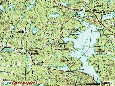
Lakes and reservoirs: Ledge Pond (A), Perkins Pond (B), Mountainview Lake (C), Mud Pond (D), Sunapee Lake (E), Wendall Marsh (F), Lake Sunapee (G), Otter Pond (H). Display/hide their locations on the map
Parks in Sunapee include: Gordon State Wildlife Management Area (1), Lincoln and Allison Gordon Wildlife Management Area (2), Wendell Marsh State Wildlife Management Area (3), Dewey Park (4). Display/hide their locations on the map
Beach: Dewey Beach (A). Display/hide its location on the map
Hotels: Burkhaven Lodge (179 Burkehaven Hill Road) (1), Sunapee Harbor Cottages (4 Lake Avenue) (2). Display/hide their approximate locations on the map
Drinking water stations with addresses in Sunapee and their reported violations in the past:
MEADOW BROOK AT SUNAPEE (Population served: 50, Groundwater):Past monitoring violations:
- 2 routine major monitoring violations
- 27 regular monitoring violations
Drinking water stations with addresses in Sunapee that have no violations reported:
- GEORGES MILLS WATER WORKS (Population served: 315, Primary Water Source Type: Groundwater)
| This town: | 2.3 people |
| New Hampshire: | 2.5 people |
| This town: | 67.4% |
| Whole state: | 66.3% |
| This town: | 8.9% |
| Whole state: | 8.3% |
Likely homosexual households (counted as self-reported same-sex unmarried-partner households)
- Lesbian couples: 0.7% of all households
- Gay men: 0.3% of all households
| This town: | 5.2% |
| Whole state: | 6.5% |
| This town: | 2.0% |
| Whole state: | 2.8% |
Banks with branches in Sunapee (2011 data):
- Sugar River Bank: Sunapee Branch at 541 Route 11, branch established on 1985/03/20. Info updated 2011/09/16: Bank assets: $265.3 mil, Deposits: $186.2 mil, headquarters in Newport, NH, positive income, 5 total offices, Holding Company: Sugar River Bancorp Mhc
- Lake Sunapee Bank, FSB: Sunapee Branch at 565 Route 11, branch established on 1965/02/15. Info updated 2011/07/21: Bank assets: $1,040.6 mil, Deposits: $808.6 mil, headquarters in Newport, NH, positive income, Mortgage Lending Specialization, 27 total offices
For population 15 years and over in Sunapee:

- Never married: 20.6%
- Now married: 60.2%
- Separated: 1.9%
- Widowed: 5.9%
- Divorced: 11.4%
For population 25 years and over in Sunapee:
- High school or higher: 92.2%
- Bachelor's degree or higher: 37.1%
- Graduate or professional degree: 14.7%
- Unemployed: 1.2%
- Mean travel time to work (commute): 24.4 minutes


| Here: | 10.6 |
| New Hampshire average: | 10.9 |
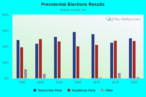
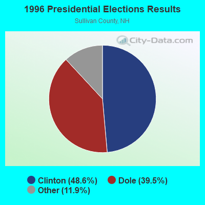
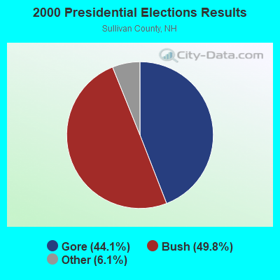
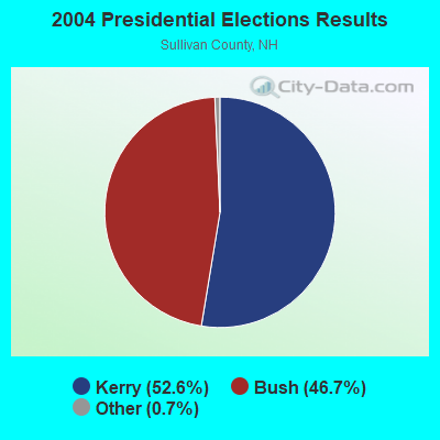
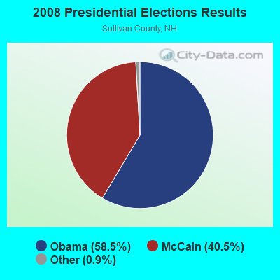
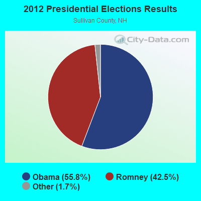
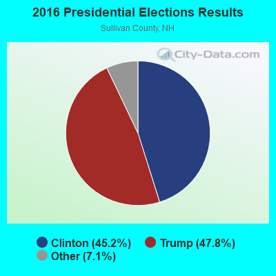
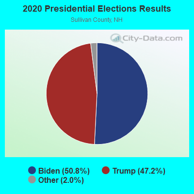
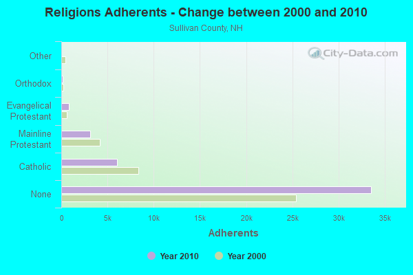
Graphs represent county-level data. Detailed 2008 Election Results
Religion statistics for Sunapee, NH (based on Sullivan County data)
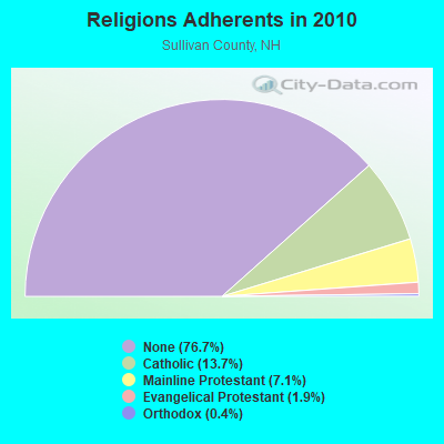
| Religion | Adherents | Congregations |
|---|---|---|
| Catholic | 6,008 | 1 |
| Mainline Protestant | 3,118 | 28 |
| Evangelical Protestant | 849 | 14 |
| Orthodox | 185 | 2 |
| Other | 29 | 2 |
| None | 33,553 | - |
Food Environment Statistics:
| This county: | 1.41 / 10,000 pop. |
| New Hampshire: | 2.14 / 10,000 pop. |
| Sullivan County: | 0.23 / 10,000 pop. |
| State: | 0.15 / 10,000 pop. |
| This county: | 1.41 / 10,000 pop. |
| State: | 1.78 / 10,000 pop. |
| This county: | 6.34 / 10,000 pop. |
| State: | 4.02 / 10,000 pop. |
| Here: | 4.93 / 10,000 pop. |
| New Hampshire: | 9.70 / 10,000 pop. |
| This county: | 8.0% |
| State: | 7.6% |
| This county: | 26.9% |
| New Hampshire: | 24.4% |
| Sullivan County: | 18.5% |
| State: | 15.9% |
Businesses in Sunapee, NH
- Decora Cabinetry: 2
- MasterBrand Cabinets: 2
Strongest AM radio stations in Sunapee:
- WNTK (1020 AM; 10 kW; NEWPORT, NH; Owner: KOOR COMMUNICATIONS, INC.)
- WRKO (680 AM; 50 kW; BOSTON, MA; Owner: ENTERCOM BOSTON LICENSE, LLC)
- WCRN (830 AM; 50 kW; WORCESTER, MA; Owner: CARTER BROADCASTING CORPORATION)
- WNNZ (640 AM; 50 kW; WESTFIELD, MA; Owner: CLEAR CHANNEL BROADCASTING LICENSES, INC.)
- WNBX (1480 AM; 5 kW; SPRINGFIELD, VT)
- WEEI (850 AM; 50 kW; BOSTON, MA; Owner: ENTERCOM BOSTON LICENSE, LLC)
- WKOX (1200 AM; 50 kW; FRAMINGHAM, MA; Owner: CAPSTAR TX LIMITED PARTNERSHIP)
- WTSV (1230 AM; 1 kW; CLAREMONT, NH; Owner: GREAT NORTHERN RADIO, L.L.C.)
- WBIX (1060 AM; 40 kW; NATICK, MA; Owner: LANGER BROADCASTING CORPORATION)
- WGY (810 AM; 50 kW; SCHENECTADY, NY; Owner: CLEAR CHANNEL BROADCASTING LICENSES, INC.)
- WVNE (760 AM; daytime; 25 kW; LEICESTER, MA; Owner: BLOUNT MASSCOM, INC.)
- WBZ (1030 AM; 50 kW; BOSTON, MA; Owner: INFINITY BROADCASTING OPERATIONS, INC.)
- WWZN (1510 AM; 50 kW; BOSTON, MA; Owner: ROSE CITY RADIO CORPORATION)
Strongest FM radio stations in Sunapee:
- WHDQ (106.1 FM; CLAREMONT, NH; Owner: GREAT NORTHERN RADIO, L.L.C.)
- WNTK-FM (99.7 FM; NEW LONDON, NH; Owner: SHEILA E. VINIKOOR)
- WVRR (101.7 FM; NEWPORT, NH; Owner: CAPSTAR TX LIMITED PARTNERSHIP)
- WVPR (89.5 FM; WINDSOR, VT; Owner: VERMONT PUBLIC RADIO)
- WSCS (90.9 FM; NEW LONDON, NH; Owner: COLBY-SAWYER COLLEGE)
- WEVH (91.3 FM; HANOVER, NH; Owner: NEW HAMPSHIRE PUBLIC RADIO INC)
- WJJR (98.1 FM; RUTLAND, VT; Owner: 6 JOHNSON ROAD LICENSES, INC.)
- WZRT (97.1 FM; RUTLAND, VT; Owner: CAPSTAR TX LIMITED PARTNERSHIP)
- WEBK (105.3 FM; KILLINGTON, VT; Owner: 6 JOHNSON ROAD LICENSES, INC.)
- WGLV (91.7 FM; WOODSTOCK, VT; Owner: CHRISTIAN MINISTRIES INC)
- WHDQ-FM1 (106.1 FM; RUTLAND, VT; Owner: GREAT NORTHERN RADIO, L.L.C.)
- WPNH-FM (100.1 FM; PLYMOUTH, NH; Owner: NORTHEAST COMMUNICATIONS CORPORATION)
- WNNH (99.1 FM; HENNIKER, NH; Owner: TELE-MEDIA COMPANY OF NEW HAMPSHIRE, L.L.C.)
- WTPL (107.7 FM; HILLSBORO, NH; Owner: CONCORD BROADCASTING, L.L.C.)
- WPKQ (103.7 FM; NORTH CONWAY, NH; Owner: CITADEL BROADCASTING COMPANY)
- WNHI (93.3 FM; BELMONT, NH; Owner: CONCORD BROADCASTING, L.L.C.)
- WHOM (94.9 FM; MT. WASHINGTON, NH; Owner: CITADEL BROADCASTING COMPANY)
- WSCY (106.9 FM; MOULTONBOROUGH, NH; Owner: NORTHEAST COMMUNICATIONS CORPORATION)
- WEQX (102.7 FM; MANCHESTER, VT; Owner: NORTHSHIRE COMMUNICATIONS, INC.)
- WZSH (107.1 FM; BELLOWS FALLS, VT; Owner: GREAT NORTHERN RADIO, L.L.C.)
TV broadcast stations around Sunapee:
- WVTA (Channel 41; WINDSOR, VT; Owner: VERMONT ETV, INC.)
- W15BK (Channel 15; HANOVER, NH; Owner: UNIVERSITY OF NEW HAMPSHIRE)
- WEKW-TV (Channel 52; KEENE, NH; Owner: UNIVERSITY OF NEW HAMPSHIRE)
- WNNE (Channel 31; HARTFORD, VT; Owner: HEARST-ARGYLE STATIONS, INC.)
- W17CI (Channel 17; CLAREMONT, NH; Owner: UPPER VALLEY BROADCASTING, LLC)

- National Bridge Inventory (NBI) Statistics
- 16Number of bridges
- 66ft / 19.8mTotal length
- $43,988,000Total costs
- 45,231Total average daily traffic
- 3,326Total average daily truck traffic

- New bridges - historical statistics
- 11900-1909
- 11910-1919
- 41920-1929
- 41950-1959
- 41960-1969
- 12000-2009
- 12010-2019
FCC Registered Broadcast Land Mobile Towers:
4- Summit Mt Sunapee (Lat: 43.314528 Lon: -72.073972), Call Sign: KNCD880,
Assigned Frequencies: 45.2200 MHz, Grant Date: 12/03/2021, Expiration Date: 12/04/2031, Registrant: Nh Dept. Of Safety/Emergency Services And Communications, 33 Hazen Dr (Mailing), Concord, NH 03305, Phone: (603) 528-7541, Fax: (603) 271-6629, Email:
- 2000 Off Rands Pond Rd (Lat: 43.332028 Lon: -72.089250), Call Sign: KVB218,
Assigned Frequencies: 151.685 MHz, Grant Date: 05/14/1997, Expiration Date: 05/18/2002, Cancellation Date: 09/22/2002, Registrant: Special Information Services Inc, 31 Pearl St, Newport, NH 03773, Phone: (603) 863-4004
- Burkehaven Hill (Lat: 43.381194 Lon: -72.078972), Call Sign: KCC468, Licensee ID: L00007153,
Assigned Frequencies: 158.250 MHz, Grant Date: 03/22/2000, Expiration Date: 05/23/2005, Cancellation Date: 04/18/2001, Registrant: Northeast Utilities Service Company, Hrtford, CT 06141-0270, Phone: (603) 669-4000
- 22 School St (Lat: 43.388333 Lon: -72.089444), Call Sign: WRUN585,
Assigned Frequencies: 452.037 MHz, Grant Date: 09/15/2022, Expiration Date: 09/15/2032, Certifier: Mathew Bouranis, Registrant: Visiplex, 1287 Barclay Boulevard, Buffalo Grove, IL 60089, Phone: (847) 229-0250, Email:
FCC Registered Microwave Towers:
3- Lat: 43.383389 Lon: -72.082861, Structure height: 1.8 m, Call Sign: WPNJ694,
Assigned Frequencies: 956.268 MHz, Grant Date: 02/10/1998, Expiration Date: 02/10/2003, Cancellation Date: 05/18/2003, Registrant: Sunapee, Town Of, Sunapee, NH 03782
- SUNAPEE OFC, 604 Sunapee Street (Lat: 43.375361 Lon: -72.128444), Type: Bant, Structure height: 3.7 m, Overall height: 6 m, Call Sign: WQMI786,
Assigned Frequencies: 11345.0 MHz, 11345.0 MHz, 11345.0 MHz, 11345.0 MHz, 11345.0 MHz, 11345.0 MHz, 11345.0 MHz, 11345.0 MHz, Grant Date: 07/22/2020, Expiration Date: 08/18/2030, Certifier: Dena Delucca, Registrant: New Hampshire Electric Cooperative, 579 Tenney Mountain Highway, Plymouth, NH 03264, Phone: (603) 536-1800, Email:
- SUNAPEE MTN, Summit Of Mt Sunapee (Lat: 43.314500 Lon: -72.073972), Type: Upole, Structure height: 7.6 m, Overall height: 16.3 m, Call Sign: WHH498,
Assigned Frequencies: 953.350 MHz, 6685.62 MHz, 6591.25 MHz, 6093.45 MHz, 6123.10 MHz, Grant Date: 06/16/2020, Expiration Date: 08/30/2030, Registrant: Nh Dept Of Safety/ Emergency Services & Communications, 33 Hazen Dr (Mailing), Concord, NH 03305, Phone: (603) 528-7541, Fax: (603) 271-6629, Email:
FCC Registered Amateur Radio Licenses:
39 (See the full list of FCC Registered Amateur Radio Licenses in Sunapee)FAA Registered Aircraft:
2- Aircraft: PIPER PA-28-161 (Category: Land, Seats: 4, Weight: Up to 12,499 Pounds, Speed: 108 mph), Engine: Reciprocating
N-Number: 284MK, N284MK, N-284MK, Serial Number: 2842135, Certificate Issue Date: 02/12/2020
Registrant (Individual): Natasha Cote, 3 Burma Rd, Sunapee, NH 03782 - Aircraft: MALCZYNSKI FRANCIS M VANS RV6 (Category: Land, Weight: Up to 12,499 Pounds), Engine: AMA/EXPR UNKNOWN ENG (Reciprocating)
N-Number: 594EF, N594EF, N-594EF, Serial Number: 22317, Year manufactured: 2002, Airworthiness Date: 09/24/2002, Certificate Issue Date: 09/24/2001
Registrant (Individual): Francis M Malczynski, 5 Upper Bay Rd, Sunapee, NH 03782
2002 - 2018 National Fire Incident Reporting System (NFIRS) incidents
- Fire incident types reported to NFIRS in Sunapee, NH
- 11359.5%Structure Fires
- 4222.1%Outside Fires
- 2312.1%Other
- 126.3%Mobile Property/Vehicle Fires
 According to the data from the years 2002 - 2018 the average number of fires per year is 11. The highest number of fire incidents - 25 took place in 2015, and the least - 1 in 2005. The data has a growing trend.
 When looking into fire subcategories, the most reports belonged to: Structure Fires (59.5%), and Outside Fires (22.1%).
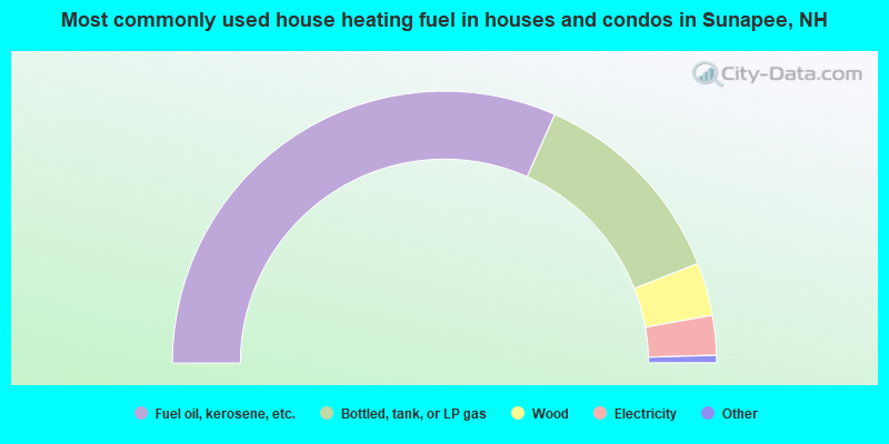
- 63.3%Fuel oil, kerosene, etc.
- 24.8%Bottled, tank, or LP gas
- 6.3%Wood
- 4.7%Electricity
- 0.5%Coal or coke
- 0.4%Utility gas
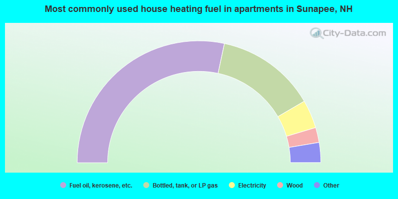
- 56.7%Fuel oil, kerosene, etc.
- 26.5%Bottled, tank, or LP gas
- 7.5%Electricity
- 4.0%Wood
- 2.8%Utility gas
- 2.5%No fuel used
Sunapee compared to New Hampshire state average:
- Unemployed percentage significantly below state average.
- Black race population percentage significantly below state average.
- Hispanic race population percentage significantly below state average.
- Foreign-born population percentage below state average.
- Length of stay since moving in significantly above state average.
- Number of rooms per house significantly below state average.
- House age significantly below state average.
- Number of college students below state average.

|
|
Total of 20 patent applications in 2008-2024.