St. Armand, New York
Submit your own pictures of this town and show them to the world
- OSM Map
- Google Map
- MSN Map
Population change since 2000: +17.2%
 |
| Males: 761 | |
| Females: 787 |
| Median resident age: | 41.3 years |
| New York median age: | 40.7 years |
Zip codes: 12913.
| St. Armand: | $75,499 |
| NY: | $79,557 |
Estimated per capita income in 2022: $40,622 (it was $18,828 in 2000)
St. Armand town income, earnings, and wages data
Estimated median house or condo value in 2022: $208,088 (it was $80,900 in 2000)
| St. Armand: | $208,088 |
| NY: | $400,400 |
Mean prices in 2022: all housing units: $276,108; detached houses: $284,996; townhouses or other attached units: $274,370; in 2-unit structures: $811,609; in 3-to-4-unit structures: $406,202; in 5-or-more-unit structures: $398,648; mobile homes: $92,731
Detailed information about poverty and poor residents in St. Armand, NY
Compare current foreclosures near St. Armand, NY:
| Photo | Address | Area | Beds / Baths | Price | Details |
|---|---|---|---|---|---|

|
#1
State Route 86
Paul Smiths, NY 12970
|
1,760 sq. feet
|
2 baths 3 beds |
$34,900
|
show details |

|
#2
Covered Bridge Ln
Jay, NY 12941
|
1,508 sq. feet
|
2 baths 3 beds |
show details | |

|
#3
Oregon Plains Rd
Vermontville, NY 12989
|
844 sq. feet
|
1 baths 3 beds |
show details | |

|
#4
Trudeau Rd
Saranac Lake, NY 12983
|
873 sq. feet
|
1 baths 2 beds |
show details | |

|
#5
Oneida Ave
Lake Placid, NY 12946
|
2,260 sq. feet
|
2 baths 4 beds |
show details | |

|
#6
Edward St
Saranac Lake, NY 12983
|
1,564 sq. feet
|
2 baths 3 beds |
show details | |

|
#7
Jenkins St
Saranac Lake, NY 12983
|
1,552 sq. feet
|
1 baths 3 beds |
show details | |

|
#8
Prescott Pl
Saranac Lake, NY 12983
|
1,686 sq. feet
|
2 baths 3 beds |
show details | |

|
#9
Neil St
Saranac Lake, NY 12983
|
800 sq. feet
|
1 baths 2 beds |
show details | |

|
#10
Ampersand Ave
Saranac Lake, NY 12983
|
1,340 sq. feet
|
2 baths 3 beds |
show details |
| Photo | Address | Area | Beds / Baths | Price | Details |
|---|---|---|---|---|---|

|
#11
Hunters Way
Lake Placid, NY 12946
|
986 sq. feet
|
1 baths 3 beds |
show details | |

|
#12
James St
Saranac Lake, NY 12983
|
1,565 sq. feet
|
1 baths 3 beds |
show details | |

|
#13
County Route 60
Vermontville, NY 12989
|
1,007 sq. feet
|
1 baths 2 beds |
show details | |

|
#14
Old Lake Colby Rd
Saranac Lake, NY 12983
|
2,834 sq. feet
|
2 baths 6 beds |
show details | |

|
#15
Bloomingdale Ave
Saranac Lake, NY 12983
|
3,275 sq. feet
|
- baths - beds |
show details | |

|
#16
Old Military Rd
Lake Placid, NY 12946
|
- sq. feet
|
2 baths 5 beds |
show details | |

|
#17
Main St
Bloomingdale, NY 12913
|
- sq. feet
|
- baths - beds |
show details | |

|
#18
Kiwassa Rd Apt 3e
Saranac Lake, NY 12983
|
- sq. feet
|
- baths - beds |
show details | |

|
#19
Margaret St # 2
Saranac Lake, NY 12983
|
- sq. feet
|
- baths - beds |
show details | |

|
#20
Chickadee Ln
Lake Placid, NY 12946
|
- sq. feet
|
- baths - beds |
show details |
| Photo | Address | Area | Beds / Baths | Price | Details |
|---|---|---|---|---|---|

|
#21
Greenwood St Apt 311
Lake Placid, NY 12946
|
- sq. feet
|
- baths - beds |
show details | |

|
#22
Poplar Ln
Bloomingdale, NY 12913
|
- sq. feet
|
- baths - beds |
show details | |

|
#23
Academy Way
Bloomingdale, NY 12913
|
- sq. feet
|
- baths - beds |
show details | |

|
#24
Sumner Pl
Saranac Lake, NY 12983
|
- sq. feet
|
- baths - beds |
show details | |

|
Check over 1 million property listings on Foreclosure.com!
|
browse all offers | |||

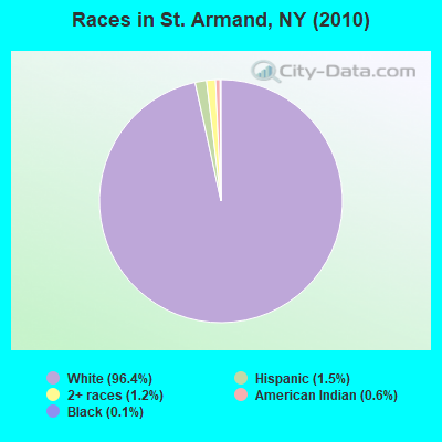
- 1,49396.4%White alone
- 231.5%Hispanic
- 191.2%Two or more races
- 90.6%American Indian alone
- 20.1%Black alone
- 10.06%Asian alone
- 10.06%Other race alone
Races in St. Armand detailed stats: ancestries, foreign born residents, place of birth
 Recent articles from our blog. Our writers, many of them Ph.D. graduates or candidates, create easy-to-read articles on a wide variety of topics.
Ancestries: Irish (24.5%), French (24.5%), German (14.5%), English (13.9%), Italian (8.3%), United States (5.9%).
Current Local Time: EST time zone
Land area: 56.5 square miles.
Population density: 27 people per square mile (very low).
27 residents are foreign born (0.9% Europe, 0.8% North America, 0.2% Oceania).
| This town: | 2.0% |
| New York: | 20.4% |
| St. Armand town: | 1.7% ($1,346) |
| New York: | 1.9% ($2,847) |
Nearest city with pop. 50,000+: Utica, NY  (107.3 miles , pop. 60,651).
Nearest city with pop. 200,000+: Rochester, NY (196.7 miles , pop. 219,773).
Nearest city with pop. 1,000,000+: Bronx, NY (245.7 miles , pop. 1,332,650).
Nearest cities:
), ), ), ), )Latitude: 44.40 N, Longitude: 74.06 W
Area code commonly used in this area: 518
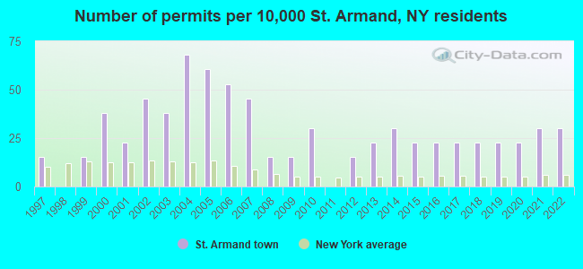
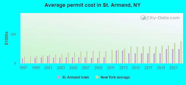
Single-family new house construction building permits:
- 2022: 4 buildings, average cost: $248,200
- 2021: 4 buildings, average cost: $248,200
- 2020: 3 buildings, average cost: $248,200
- 2019: 3 buildings, average cost: $175,000
- 2018: 3 buildings, average cost: $175,000
- 2017: 3 buildings, average cost: $175,000
- 2016: 3 buildings, average cost: $175,000
- 2015: 3 buildings, average cost: $175,000
- 2014: 4 buildings, average cost: $175,000
- 2013: 3 buildings, average cost: $225,000
- 2012: 2 buildings, average cost: $225,000
- 2010: 4 buildings, average cost: $105,800
- 2009: 2 buildings, average cost: $97,500
- 2008: 2 buildings, average cost: $97,500
- 2007: 6 buildings, average cost: $106,800
- 2006: 7 buildings, average cost: $106,800
- 2005: 8 buildings, average cost: $106,800
- 2004: 9 buildings, average cost: $106,800
- 2003: 5 buildings, average cost: $102,300
- 2002: 6 buildings, average cost: $102,300
- 2001: 3 buildings, average cost: $129,300
- 2000: 5 buildings, average cost: $106,000
- 1999: 2 buildings, average cost: $100,000
- 1997: 2 buildings, average cost: $85,800
| Here: | 4.7% |
| New York: | 4.4% |
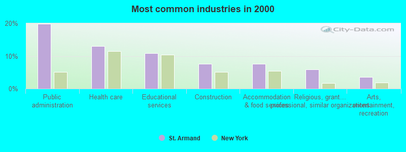
- Public administration (19.9%)
- Health care (13.0%)
- Educational services (10.8%)
- Construction (7.5%)
- Accommodation & food services (7.5%)
- Religious, grantmaking, civic, professional, similar organizations (5.9%)
- Arts, entertainment, recreation (3.6%)
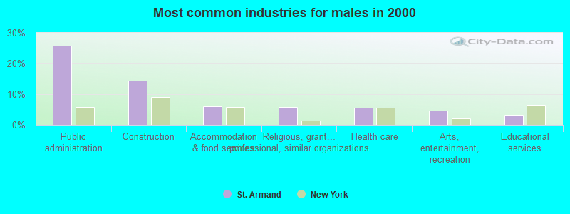
- Public administration (25.9%)
- Construction (14.5%)
- Accommodation & food services (6.1%)
- Religious, grantmaking, civic, professional, similar organizations (5.8%)
- Health care (5.5%)
- Arts, entertainment, recreation (4.7%)
- Educational services (3.2%)
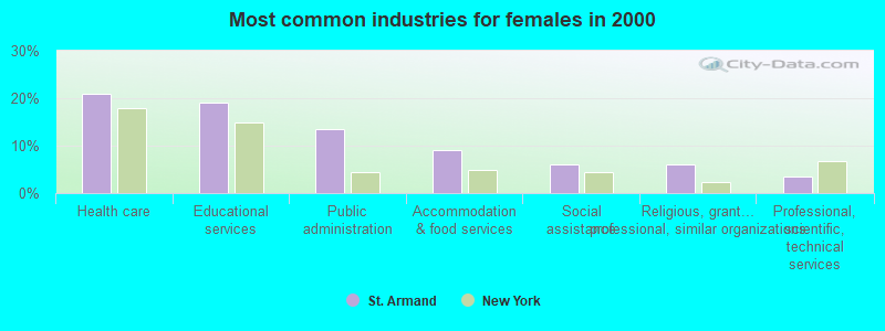
- Health care (20.9%)
- Educational services (19.1%)
- Public administration (13.4%)
- Accommodation & food services (9.1%)
- Social assistance (5.9%)
- Religious, grantmaking, civic, professional, similar organizations (5.9%)
- Professional, scientific, technical services (3.4%)
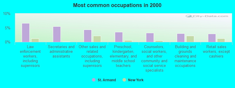
- Law enforcement workers, including supervisors (6.6%)
- Secretaries and administrative assistants (5.4%)
- Other sales and related occupations, including supervisors (4.4%)
- Preschool, kindergarten, elementary, and middle school teachers (3.5%)
- Counselors, social workers, and other community and social service specialists (3.2%)
- Building and grounds cleaning and maintenance occupations (3.0%)
- Retail sales workers, except cashiers (2.9%)
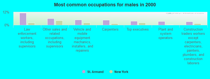
- Law enforcement workers, including supervisors (11.3%)
- Other sales and related occupations, including supervisors (6.1%)
- Vehicle and mobile equipment mechanics, installers, and repairers (4.9%)
- Carpenters (4.7%)
- Top executives (3.8%)
- Plant and system operators (3.5%)
- Construction traders workers except carpenters, electricians, painters, plumbers, and construction laborers (3.2%)
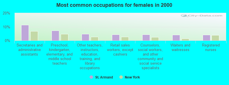
- Secretaries and administrative assistants (11.2%)
- Preschool, kindergarten, elementary, and middle school teachers (7.2%)
- Other teachers, instructors, education, training, and library occupations (4.7%)
- Retail sales workers, except cashiers (4.4%)
- Counselors, social workers, and other community and social service specialists (4.4%)
- Waiters and waitresses (4.1%)
- Registered nurses (4.1%)
Average climate in St. Armand, New York
Based on data reported by over 4,000 weather stations


(lower is better)
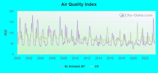
Air Quality Index (AQI) level in 2023 was 77.4. This is about average.
| City: | 77.4 |
| U.S.: | 72.6 |
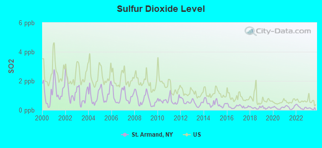
Sulfur Dioxide (SO2) [ppb] level in 2023 was 0.100. This is significantly better than average. Closest monitor was 9.6 miles away from the city center.
| City: | 0.100 |
| U.S.: | 1.515 |
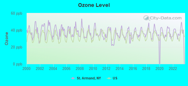
Ozone [ppb] level in 2023 was 40.2. This is worse than average. Closest monitor was 8.0 miles away from the city center.
| City: | 40.2 |
| U.S.: | 33.3 |
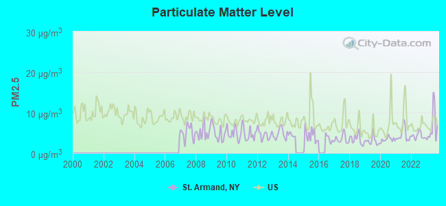
Particulate Matter (PM2.5) [µg/m3] level in 2023 was 6.51. This is better than average. Closest monitor was 9.9 miles away from the city center.
| City: | 6.51 |
| U.S.: | 8.11 |
Earthquake activity:
St. Armand-area historical earthquake activity is significantly above New York state average. It is 71% smaller than the overall U.S. average.On 4/20/2002 at 10:50:47, a magnitude 5.3 (5.3 ML, Depth: 3.0 mi, Class: Moderate, Intensity: VI - VII) earthquake occurred 19.6 miles away from the city center
On 10/7/1983 at 10:18:46, a magnitude 5.3 (5.1 MB, 5.3 LG, 5.1 ML) earthquake occurred 33.8 miles away from the city center
On 4/20/2002 at 10:50:47, a magnitude 5.2 (5.2 MB, 4.2 MS, 5.2 MW, 5.0 MW) earthquake occurred 18.0 miles away from the city center
On 1/19/1982 at 00:14:42, a magnitude 4.7 (4.5 MB, 4.7 MD, 4.5 LG, Class: Light, Intensity: IV - V) earthquake occurred 137.3 miles away from the city center
On 10/16/2012 at 23:12:25, a magnitude 4.7 (4.7 ML, Depth: 10.0 mi) earthquake occurred 178.1 miles away from St. Armand center
On 4/20/2000 at 08:46:55, a magnitude 3.8 (3.8 ML, Depth: 3.1 mi, Class: Light, Intensity: II - III) earthquake occurred 32.5 miles away from St. Armand center
Magnitude types: regional Lg-wave magnitude (LG), body-wave magnitude (MB), duration magnitude (MD), local magnitude (ML), surface-wave magnitude (MS), moment magnitude (MW)
Natural disasters:
The number of natural disasters in Essex County (19) is greater than the US average (15).Major Disasters (Presidential) Declared: 12
Emergencies Declared: 5
Causes of natural disasters: Storms: 8, Floods: 7, Hurricanes: 4, Winds: 2, Winter Storms: 2, Blizzard: 1, Earthquake: 1, Power Outage: 1, Snowstorm: 1, Tornado: 1, Other: 2 (Note: some incidents may be assigned to more than one category).
Colleges/universities with over 2000 students nearest to St. Armand:
- SUNY College at Plattsburgh (about 36 miles; Plattsburgh, NY; Full-time enrollment: 5,934)
- Champlain College (about 43 miles; Burlington, VT; FT enrollment: 2,623)
- University of Vermont (about 43 miles; Burlington, VT; FT enrollment: 11,566)
- Community College of Vermont (about 44 miles; Winooski, VT; FT enrollment: 3,394)
- Saint Michael's College (about 45 miles; Colchester, VT; FT enrollment: 2,336)
- SUNY College at Potsdam (about 49 miles; Potsdam, NY; FT enrollment: 4,307)
- Clarkson University (about 50 miles; Potsdam, NY; FT enrollment: 3,472)
Points of interest:
Notable locations in St. Armand: Saranac Lake Village Water Pollution Control Plant (A), Saint Armand Sewer District Wastewater Treatment Plant (B), Mount Pisgah Ski Area (C), Robert Louis Stevenson Memorial Cottage (D). Display/hide their locations on the map
Cemeteries: Brookside Cemetery (1), Goodspeed Cemetery (2). Display/hide their locations on the map
Lakes: Loch Bonnie (A), Moose Pond (B), Grass Pond (C). Display/hide their locations on the map
Streams, rivers, and creeks: Grass Pond Outlet (A), Falls Brook (B), Cold Brook (C), Sumner Brook (D), Still Brook (E), Moose Creek (F). Display/hide their locations on the map
| This town: | 2.4 people |
| New York: | 2.6 people |
| This town: | 64.7% |
| Whole state: | 63.5% |
| This town: | 7.9% |
| Whole state: | 6.8% |
Likely homosexual households (counted as self-reported same-sex unmarried-partner households)
- Lesbian couples: 0.3% of all households
- Gay men: 0.2% of all households
| This town: | 8.1% |
| Whole state: | 14.6% |
| This town: | 2.8% |
| Whole state: | 7.4% |
For population 15 years and over in St. Armand:
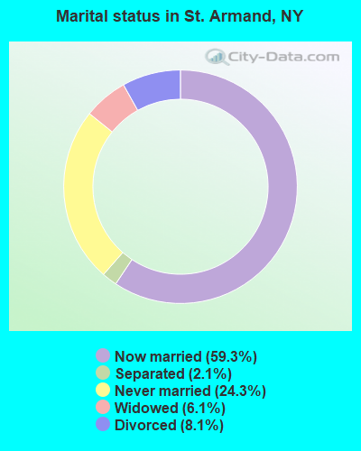
- Never married: 24.3%
- Now married: 59.3%
- Separated: 2.1%
- Widowed: 6.1%
- Divorced: 8.1%
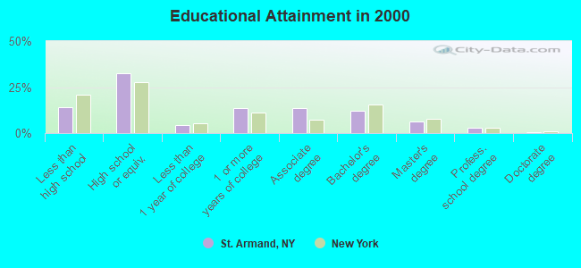
For population 25 years and over in St. Armand:
- High school or higher: 85.8%
- Bachelor's degree or higher: 22.0%
- Graduate or professional degree: 9.8%
- Unemployed: 5.7%
- Mean travel time to work (commute): 19.2 minutes
| Here: | 10.3 |
| New York average: | 14.2 |
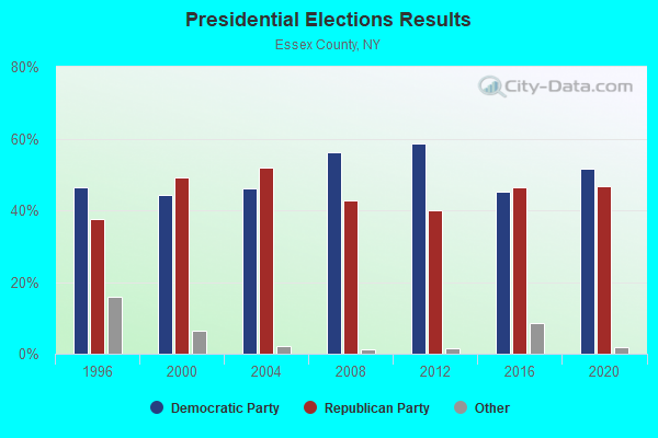
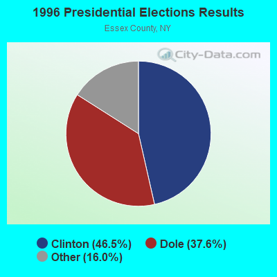
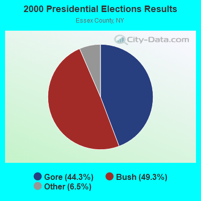
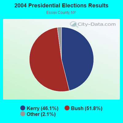
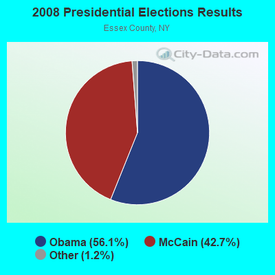
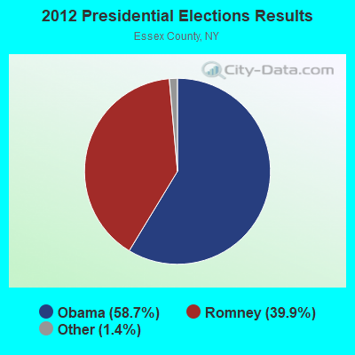
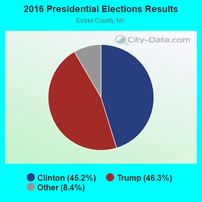
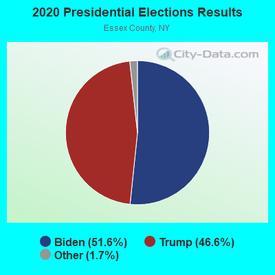
Graphs represent county-level data. Detailed 2008 Election Results
Religion statistics for St. Armand, NY (based on Essex County data)
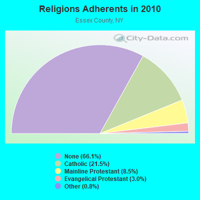
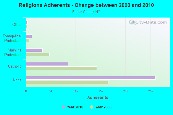
| Religion | Adherents | Congregations |
|---|---|---|
| Catholic | 8,467 | 17 |
| Mainline Protestant | 3,360 | 33 |
| Evangelical Protestant | 1,197 | 13 |
| Other | 328 | 4 |
| None | 26,018 | - |
Food Environment Statistics:
| Essex County: | 6.33 / 10,000 pop. |
| New York: | 4.13 / 10,000 pop. |
| Essex County: | 0.26 / 10,000 pop. |
| New York: | 0.06 / 10,000 pop. |
| Essex County: | 1.32 / 10,000 pop. |
| New York: | 0.92 / 10,000 pop. |
| Here: | 6.07 / 10,000 pop. |
| New York: | 1.68 / 10,000 pop. |
| This county: | 18.99 / 10,000 pop. |
| State: | 8.82 / 10,000 pop. |
| Essex County: | 7.8% |
| New York: | 8.2% |
| Essex County: | 22.6% |
| New York: | 23.8% |
| This county: | 16.0% |
| New York: | 15.6% |
Strongest AM radio stations in St. Armand:
- WIRD (920 AM; 5 kW; LAKE PLACID, NY; Owner: RADIO LAKE PLACID INC)
- WICY (1490 AM; 50 kW; MALONE, NY; Owner: CARTIER COMMUNICATIONS INC.)
- WNBZ (1240 AM; 1 kW; SARANAC LAKE, NY; Owner: SARANAC LAKE RADIO, L.L.C.)
- WCHP (760 AM; 35 kW; CHAMPLAIN, NY; Owner: CHAMPLAIN RADIO, INC.)
- WGY (810 AM; 50 kW; SCHENECTADY, NY; Owner: CLEAR CHANNEL BROADCASTING LICENSES, INC.)
- WEAV (960 AM; 5 kW; PLATTSBURGH, NY; Owner: CLEAR CHANNEL BROADCASTING LICENSES, INC.)
- WTWK (1070 AM; daytime; 5 kW; PLATTSBURGH, NY; Owner: CHAMPLAIN COMMUNICATIONS CORPORATION)
- WVMT (620 AM; 5 kW; BURLINGTON, VT; Owner: SISON BROADCASTING, INC.)
- WNNZ (640 AM; 50 kW; WESTFIELD, MA; Owner: CLEAR CHANNEL BROADCASTING LICENSES, INC.)
- WPTR (1540 AM; 50 kW; ALBANY, NY; Owner: KIMTRON, INC.)
- WVAA (1390 AM; 5 kW; BURLINGTON, VT; Owner: RADIO VERMONT, KDR, LLC)
- WDEV (550 AM; 5 kW; WATERBURY, VT; Owner: RADIO VERMONT, INC.)
- WRKO (680 AM; 50 kW; BOSTON, MA; Owner: ENTERCOM BOSTON LICENSE, LLC)
Strongest FM radio stations in St. Armand:
- WSLL (90.5 FM; SARANAC LAKE, NY; Owner: THE ST. LAWRENCE UNIVERSITY)
- WYZY (106.3 FM; SARANAC LAKE, NY; Owner: SARANAC LAKE RADIO, L.L.C.)
- WYUL (94.7 FM; CHATEAUGAY, NY; Owner: CARTIER COMMUNICATIONS INC.)
- WCEL (91.9 FM; PLATTSBURGH, NY; Owner: WAMC)
- WRGR (102.3 FM; TUPPER LAKE, NY; Owner: RADIO LAKE PLACID, INC.)
- WXLU (88.3 FM; PERU, NY; Owner: THE ST. LAWRENCE UNIVERSITY)
- WXLH (91.3 FM; BLUE MOUNTAIN LAKE, NY; Owner: THE ST. LAWRENCE UNIVERSITY)
- WCVT (101.7 FM; STOWE, VT; Owner: RADIO VERMONT CLASSICS, L.L.C.)
- WEZF (92.9 FM; BURLINGTON, VT; Owner: CAPSTAR TX LIMITED PARTNERSHIP)
- WVPS (107.9 FM; BURLINGTON, VT; Owner: VERMONT PUBLIC RADIO)
- WXLG (89.9 FM; NORTH CREEK, NY; Owner: THE ST. LAWRENCE UNIVERSITY)
- WLPW (105.5 FM; LAKE PLACID, NY; Owner: RADIO LAKE PLACID INC.)
- WLKC (103.3 FM; WATERBURY, VT; Owner: RADIO BROADCASTING SERVICES, INC.)
- WDEV-FM (96.1 FM; WARREN, VT; Owner: RADIO VERMONT, INC.)
- WBTZ (99.9 FM; PLATTSBURGH, NY; Owner: PLATTSBURGH BROADCASTING CORPORATION)
- WNCS (104.7 FM; MONTPELIER, VT; Owner: MONTPELIER BROADCASTING, INC.)
- WVNV (96.5 FM; MALONE, NY; Owner: CARTIER COMMUNICATIONS INC.)
TV broadcast stations around St. Armand:
- WPTZ (Channel 5; NORTH POLE, NY; Owner: HEARST-ARGYLE STATIONS, INC.)
- WCFE-TV (Channel 57; PLATTSBURGH, NY; Owner: MOUNTAIN LAKE PUBLIC TELEVISION COUNCIL)
- National Bridge Inventory (NBI) Statistics
- 6Number of bridges
- 43ft / 12.6mTotal length
- $5,608,000Total costs
- 6,469Total average daily traffic
- 416Total average daily truck traffic
- 8,284Total future (year 2029) average daily traffic
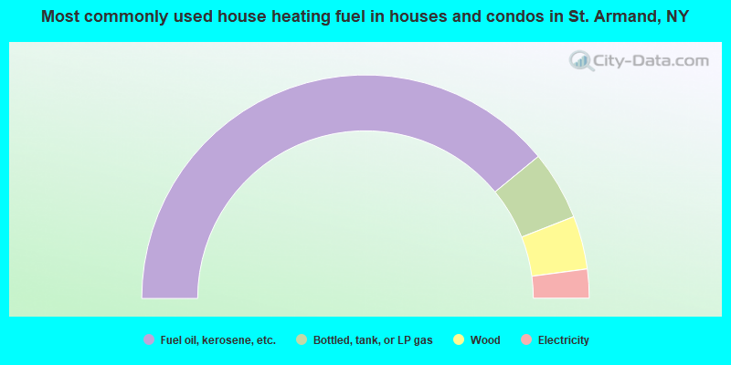
- 78.1%Fuel oil, kerosene, etc.
- 10.0%Bottled, tank, or LP gas
- 7.7%Wood
- 4.2%Electricity
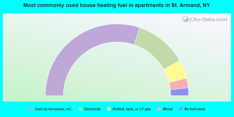
- 60.3%Fuel oil, kerosene, etc.
- 23.4%Electricity
- 8.5%Bottled, tank, or LP gas
- 4.3%Wood
- 3.5%No fuel used
St. Armand compared to New York state average:
- Median house value below state average.
- Unemployed percentage below state average.
- Black race population percentage significantly below state average.
- Hispanic race population percentage significantly below state average.
- Foreign-born population percentage significantly below state average.
- Renting percentage below state average.
- Length of stay since moving in significantly above state average.
- Number of rooms per house significantly below state average.
- House age significantly below state average.
- Number of college students below state average.