South Benton, Washington
Submit your own pictures of this place and show them to the world
- OSM Map
- General Map
- Google Map
- MSN Map

| Males: 490 | |
| Females: 434 |
| Median resident age: | 28.3 years |
| Washington median age: | 35.3 years |
Zip code: 99345
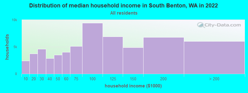
| South Benton: | $65,905 |
| WA: | $91,306 |
Estimated per capita income in 2022: $23,130 (it was $12,566 in 2000)
South Benton CCD income, earnings, and wages data
Estimated median house or condo value in 2022: $245,312 (it was $69,200 in 2000)
| South Benton: | $245,312 |
| WA: | $569,500 |
Mean prices in 2022: all housing units: $421,734; detached houses: $455,586; townhouses or other attached units: $404,697; in 2-unit structures: $288,506; in 3-to-4-unit structures: $486,803; in 5-or-more-unit structures: $225,689; mobile homes: $195,010; occupied boats, rvs, vans, etc.: $160,038
Detailed information about poverty and poor residents in South Benton, WA


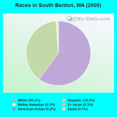
- 50060.2%White alone
- 31938.4%Hispanic
- 40.5%Native Hawaiian and Other
Pacific Islander alone - 40.5%Two or more races
- 20.2%American Indian alone
- 10.1%Asian alone
Races in South Benton detailed stats: ancestries, foreign born residents, place of birth
 Recent articles from our blog. Our writers, many of them Ph.D. graduates or candidates, create easy-to-read articles on a wide variety of topics.
Current Local Time: PST time zone
Land area: 597.0 square miles.
Population density: 1.5 people per square mile (very low).

| South Benton CCD: | 1.4% ($971) |
| Washington: | 1.2% ($1,915) |
Nearest city with pop. 50,000+: Kennewick, WA  (20.3 miles , pop. 54,693).
Nearest city with pop. 200,000+: Portland, OR (156.9 miles , pop. 529,121).
Nearest city with pop. 1,000,000+: Los Angeles, CA (825.8 miles , pop. 3,694,820).
Nearest cities:
), )Latitude: 46.00 N, Longitude: 119.46 W
Area code commonly used in this area: 541

| Here: | 5.4% |
| Washington: | 4.6% |
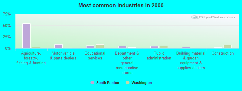
- Agriculture, forestry, fishing & hunting (54.5%)
- Motor vehicle & parts dealers (8.5%)
- Educational services (5.9%)
- Department & other general merchandise stores (5.4%)
- Public administration (4.5%)
- Building material & garden equipment & supplies dealers (3.1%)
- Construction (2.0%)
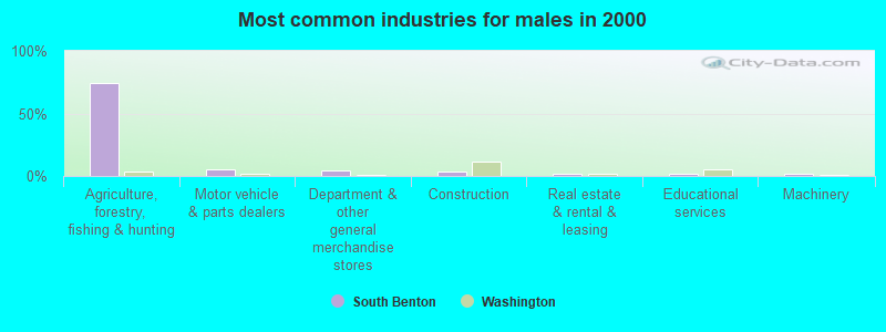
- Agriculture, forestry, fishing & hunting (74.3%)
- Motor vehicle & parts dealers (5.1%)
- Department & other general merchandise stores (4.7%)
- Construction (3.3%)
- Real estate & rental & leasing (1.9%)
- Educational services (1.9%)
- Machinery (1.4%)
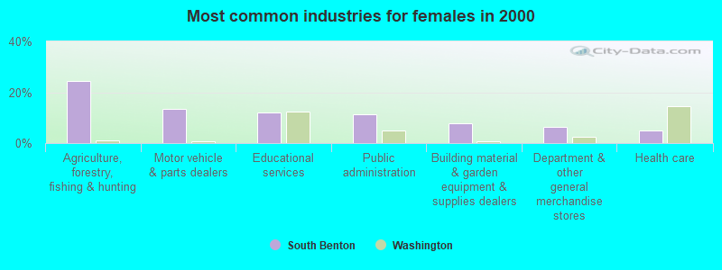
- Agriculture, forestry, fishing & hunting (24.3%)
- Motor vehicle & parts dealers (13.6%)
- Educational services (12.1%)
- Public administration (11.4%)
- Building material & garden equipment & supplies dealers (7.9%)
- Department & other general merchandise stores (6.4%)
- Health care (5.0%)
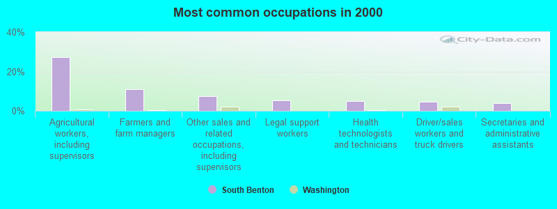
- Agricultural workers, including supervisors (27.4%)
- Farmers and farm managers (11.0%)
- Other sales and related occupations, including supervisors (7.3%)
- Legal support workers (5.4%)
- Health technologists and technicians (4.8%)
- Driver/sales workers and truck drivers (4.5%)
- Secretaries and administrative assistants (4.0%)
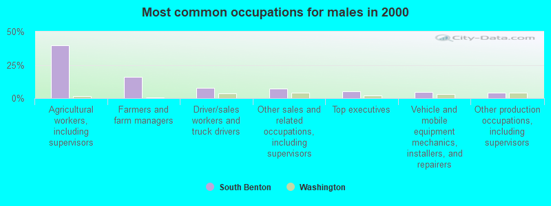
- Agricultural workers, including supervisors (39.7%)
- Farmers and farm managers (15.9%)
- Driver/sales workers and truck drivers (7.5%)
- Other sales and related occupations, including supervisors (7.0%)
- Top executives (5.1%)
- Vehicle and mobile equipment mechanics, installers, and repairers (4.7%)
- Other production occupations, including supervisors (4.2%)
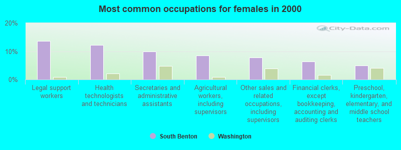
- Legal support workers (13.6%)
- Health technologists and technicians (12.1%)
- Secretaries and administrative assistants (10.0%)
- Agricultural workers, including supervisors (8.6%)
- Other sales and related occupations, including supervisors (7.9%)
- Financial clerks, except bookkeeping, accounting and auditing clerks (6.4%)
- Preschool, kindergarten, elementary, and middle school teachers (5.0%)
Average climate in South Benton, Washington
Based on data reported by over 4,000 weather stations


(lower is better)
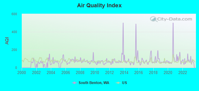
Air Quality Index (AQI) level in 2023 was 68.4. This is about average.
| City: | 68.4 |
| U.S.: | 72.6 |
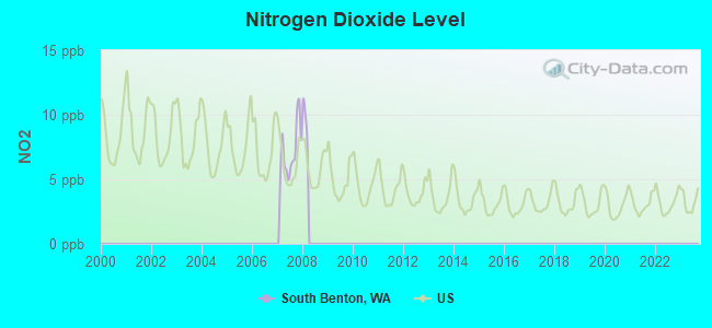
Nitrogen Dioxide (NO2) [ppb] level in 2007 was 7.16. This is significantly worse than average. Closest monitor was 15.0 miles away from the city center.
| City: | 7.16 |
| U.S.: | 5.11 |
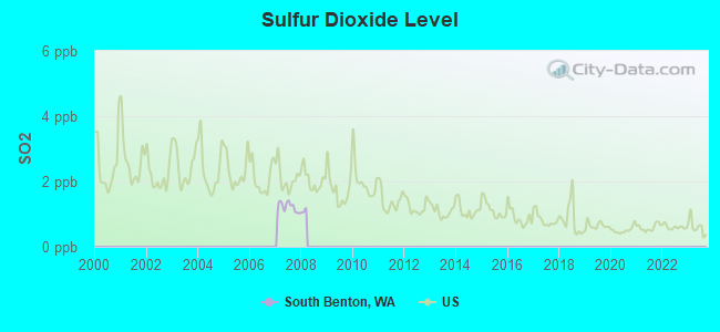
Sulfur Dioxide (SO2) [ppb] level in 2007 was 1.22. This is better than average. Closest monitor was 15.0 miles away from the city center.
| City: | 1.22 |
| U.S.: | 1.51 |
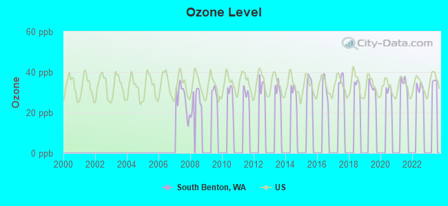
Ozone [ppb] level in 2008 was 26.3. This is better than average. Closest monitor was 15.0 miles away from the city center.
| City: | 26.3 |
| U.S.: | 33.3 |
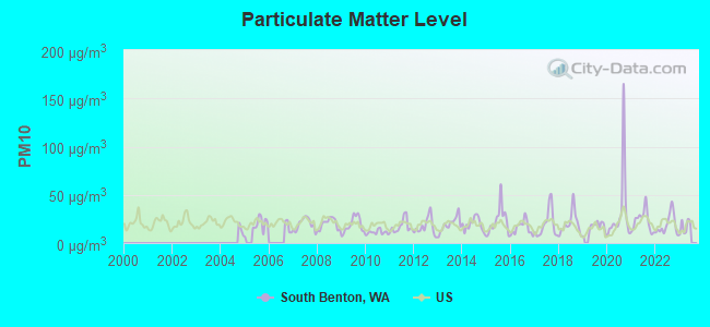
Particulate Matter (PM10) [µg/m3] level in 2022 was 18.9. This is about average. Closest monitor was 19.6 miles away from the city center.
| City: | 18.9 |
| U.S.: | 19.2 |
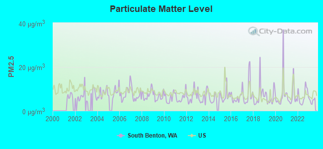
Particulate Matter (PM2.5) [µg/m3] level in 2023 was 4.58. This is significantly better than average. Closest monitor was 13.8 miles away from the city center.
| City: | 4.58 |
| U.S.: | 8.11 |
Earthquake activity:
South Benton-area historical earthquake activity is significantly above Washington state average. It is 1348% greater than the overall U.S. average.On 4/13/1949 at 19:55:42, a magnitude 7.0 (7.0 UK, Class: Major, Intensity: VIII - XII) earthquake occurred 168.4 miles away from the city center, causing $80,000,000 total damage
On 2/28/2001 at 18:54:32, a magnitude 6.8 (6.5 MB, 6.6 MS, 6.8 MW, Class: Strong, Intensity: VII - IX) earthquake occurred 166.6 miles away from South Benton center, causing $2,000,000,000 total damage and $305,000,000 insured losses
On 2/28/2001 at 18:54:32, a magnitude 6.8 (6.8 MD, Depth: 32.2 mi) earthquake occurred 174.6 miles away from the city center
On 10/28/1983 at 14:06:06, a magnitude 7.3 (6.2 MB, 7.3 MS, 7.0 MW) earthquake occurred 306.7 miles away from South Benton center, causing 2 deaths (2 shaking deaths) and 3 injuries, causing $15,000,000 total damage
On 4/29/1965 at 15:28:43, a magnitude 6.6 (6.6 UK) earthquake occurred 164.1 miles away from South Benton center, causing $28,000,000 total damage
On 10/3/1915 at 06:52:48, a magnitude 7.6 (7.6 UK) earthquake occurred 392.8 miles away from South Benton center
Magnitude types: body-wave magnitude (MB), duration magnitude (MD), surface-wave magnitude (MS), moment magnitude (MW)
Natural disasters:
The number of natural disasters in Benton County (16) is near the US average (15).Major Disasters (Presidential) Declared: 11
Emergencies Declared: 2
Causes of natural disasters: Floods: 9, Storms: 5, Mudslides: 3, Winter Storms: 3, Fires: 2, Landslides: 2, Drought: 1, Earthquake: 1, Heavy Rain: 1, Hurricane: 1, Snow: 1, Volcanic Eruption: 1, Other: 1 (Note: some incidents may be assigned to more than one category).
Hospitals and medical centers near South Benton:
- TLC HOME HEALTH (Home Health Center, about 13 miles away; HERMISTON, OR)
- HERMISTON COMMUNITY DIALYSIS CENTER (Dialysis Facility, about 13 miles away; HERMISTON, OR)
- GOOD SHEPHERD MEDICAL CENTER Critical Access Hospitals (about 13 miles away; HERMISTON, OR)
- HERMISTON GOOD SAMARITAN (Nursing Home, about 14 miles away; HERMISTON, OR)
- REGENCY HERMISTON NURSING AND REHAB CENTER (Nursing Home, about 14 miles away; HERMISTON, OR)
- VANGE JOHN MEMORIAL HOSPICE (Hospital, about 14 miles away; HERMISTON, OR)
Colleges/universities with over 2000 students nearest to South Benton:
- Columbia Basin College (about 25 miles; Pasco, WA; Full-time enrollment: 5,111)
- Walla Walla Community College (about 57 miles; Walla Walla, WA; FT enrollment: 4,263)
- Yakima Valley Community College (about 66 miles; Yakima, WA; FT enrollment: 3,632)
- Eastern Oregon University (about 81 miles; La Grande, OR; FT enrollment: 3,127)
- Central Washington University (about 87 miles; Ellensburg, WA; FT enrollment: 10,960)
- Wenatchee Valley College (about 108 miles; Wenatchee, WA; FT enrollment: 2,951)
- Lewis-Clark State College (about 120 miles; Lewiston, ID; FT enrollment: 3,199)
Points of interest:
Notable locations in South Benton: Lenzie Ranch (A), Mottinger (B), Prior Ranch (C), Sage (D), Youngs Ranch (E), Berrian (F), Barger (G), Benton County Fire District 6 (H), Benton County Fire Protection District 5 Station 540 (I). Display/hide their locations on the map
Lakes and reservoirs: Mound Pond (A), Palmer Pond (B), Switch Pond (C), Yellepit Pond (D), Lake Wallula (E), Sandpiper Farms Leveling Pond (F). Display/hide their locations on the map
Creek: Glade Creek (A). Display/hide its location on the map
Parks in South Benton include: Plymouth Park (1), John Day Wildlife Management Area (2), Crow Butte State Park (3), Umatilla National Wildlife Refuge (4). Display/hide their locations on the map
| This place: | 2.9 people |
| Washington: | 2.5 people |
| This place: | 72.6% |
| Whole state: | 64.4% |
| This place: | 4.4% |
| Whole state: | 7.7% |
No gay or lesbian households reported
| This place: | 15.1% |
| Whole state: | 10.6% |
| This place: | 1.3% |
| Whole state: | 4.6% |
For population 15 years and over in South Benton:
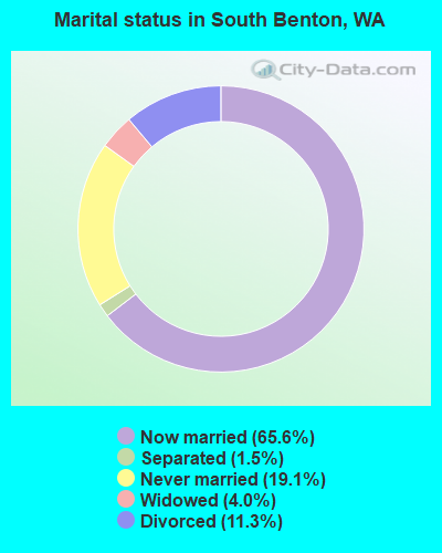
- Never married: 19.1%
- Now married: 65.6%
- Separated: 1.5%
- Widowed: 4.0%
- Divorced: 11.3%
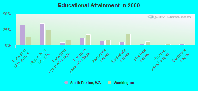
For population 25 years and over in South Benton:
- High school or higher: 67.2%
- Bachelor's degree or higher: 8.9%
- Graduate or professional degree: 4.2%
- Unemployed: 4.6%
- Mean travel time to work (commute): 14.9 minutes
| Here: | 22.0 |
| Washington average: | 11.3 |
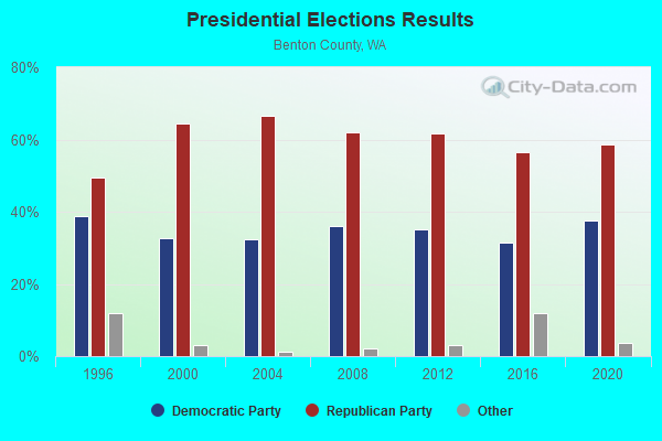
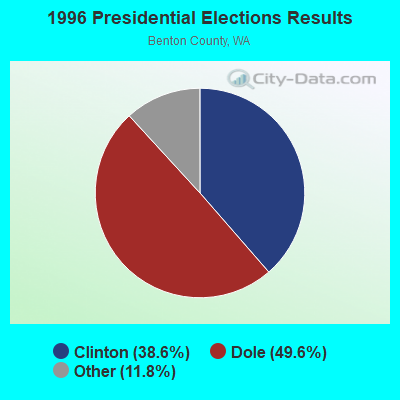
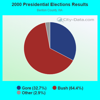
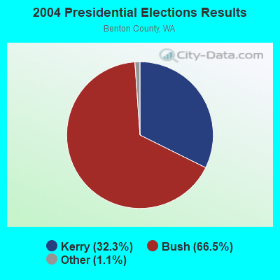

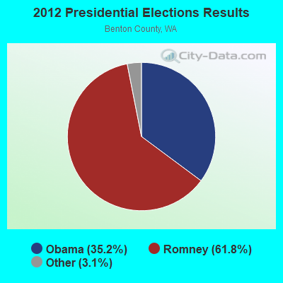
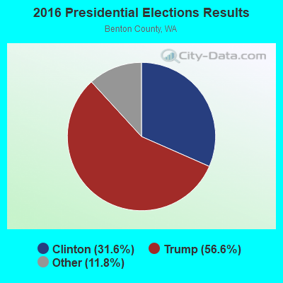
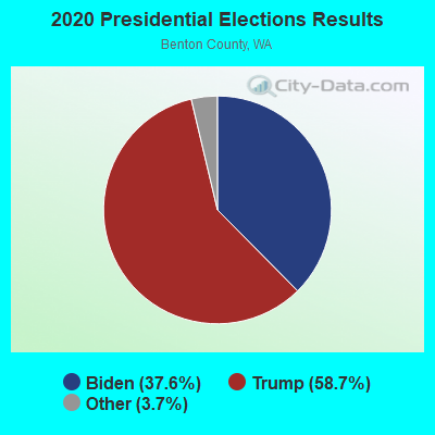
Graphs represent county-level data. Detailed 2008 Election Results
Religion statistics for South Benton, WA (based on Benton County data)
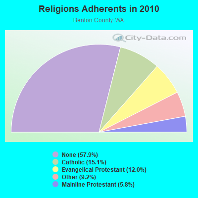
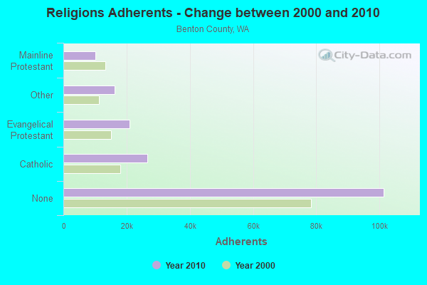
| Religion | Adherents | Congregations |
|---|---|---|
| Catholic | 26,500 | 5 |
| Evangelical Protestant | 20,943 | 86 |
| Other | 16,145 | 43 |
| Mainline Protestant | 10,217 | 28 |
| None | 101,372 | - |
Food Environment Statistics:
| Benton County: | 1.20 / 10,000 pop. |
| Washington: | 2.06 / 10,000 pop. |
| Here: | 0.25 / 10,000 pop. |
| State: | 0.19 / 10,000 pop. |
| Benton County: | 0.63 / 10,000 pop. |
| Washington: | 1.18 / 10,000 pop. |
| Benton County: | 3.40 / 10,000 pop. |
| Washington: | 2.67 / 10,000 pop. |
| This county: | 6.11 / 10,000 pop. |
| Washington: | 8.26 / 10,000 pop. |
| Benton County: | 8.2% |
| Washington: | 7.7% |
| Benton County: | 27.5% |
| Washington: | 25.7% |
| Here: | 9.9% |
| Washington: | 13.9% |
Strongest AM radio stations in South Benton:
- KOHU (1360 AM; 4 kW; HERMISTON, OR; Owner: WESTEND RADIO, LLC)
- KLWJ (1090 AM; daytime; 2 kW; UMATILLA, OR; Owner: UMATILLA BROADCASTING, INC.)
- KFLD (870 AM; 10 kW; PASCO, WA; Owner: CAPSTAR TX LIMITED PARTNERSHIP)
- KONA (610 AM; 5 kW; KENNEWICK-RICHLAND-P, WA; Owner: COMMONWEALTH LICENSE SUBSIDIARY, LLC)
- KALE (960 AM; 5 kW; RICHLAND, WA; Owner: NEW NORTHWEST BROADCASTERS, LLC)
- KZXR (1310 AM; 5 kW; PROSSER, WA; Owner: MOON BROADCASTING PROSSER LLC)
- KTBI (810 AM; daytime; 50 kW; EPHRATA, WA; Owner: TACOMA BROADCASTERS, INCORPORATED)
- KZTS (1210 AM; 10 kW; SUNNYSIDE, WA; Owner: BUTTERFIELD BROADCASTING CORPORATION)
- KPOJ (620 AM; 50 kW; PORTLAND, OR; Owner: CITICASTERS LICENSES, L.P.)
- KXL (750 AM; 50 kW; PORTLAND, OR; Owner: ROSE CITY RADIO CORPORATION)
- KPAM (860 AM; 50 kW; TROUTDALE, OR; Owner: PAMPLIN BROADCASTING-OREGON, INC.)
- KYAK (930 AM; 10 kW; YAKIMA, WA)
- KUMA (1290 AM; 5 kW; PENDLETON, OR; Owner: ROUND-UP RADIO, INC.)
Strongest FM radio stations in South Benton:
- KFAE-FM (89.1 FM; RICHLAND, WA; Owner: WASHINGTON STATE UNIVERSITY)
- KONA-FM (105.3 FM; KENNEWICK, WA; Owner: COMMONWEALTH LICENSE SUBSIDIARY, LLC)
- KORD-FM (102.7 FM; RICHLAND, WA; Owner: CAPSTAR TX LIMITED PARTNERSHIP)
- KEGX (106.5 FM; RICHLAND, WA; Owner: NEW NORTHWEST BROADCASTERS, LLC)
- KGDN (101.3 FM; PASCO, WA; Owner: WEST PASCO FINE ARTS RADIO)
- KEYW (98.3 FM; PASCO, WA; Owner: CAPSTAR TX LIMITED PARTNERSHIP)
- KOLU (90.1 FM; PASCO, WA; Owner: RIVERVIEW BAPTIST CHRISTIAN SCHOOLS)
- KBLD (91.7 FM; KENNEWICK, WA; Owner: CSN INTERNATIONAL)
- KGSG (93.7 FM; PASCO, WA; Owner: GOSPEL MUSIC BROADCASTING CORP.)
- K261CG (100.1 FM; PASCO, WA; Owner: NORTHWEST CHICANO RADIO NETWORK)
- K204CZ (88.7 FM; KENNEWICK, WA; Owner: CALVARY CHAPEL OF TWIN FALLS, INC.)
- KXRX (97.1 FM; WALLA WALLA, WA; Owner: CAPSTAR TX LIMITED PARTNERSHIP)
- KIOK (94.9 FM; RICHLAND, WA; Owner: NEW NORTHWEST BROADCASTERS, LLC)
- KMNA (101.7 FM; PROSSER, WA; Owner: MOON BROADCASTING PROSSER LLC)
- K204DH (88.7 FM; HANFORD, WA; Owner: CALVARY CHAPEL OF TWIN FALLS, INC.)
- KLES (98.7 FM; MABTON, WA; Owner: ON-AIR FAMILY, LLC)
- KQFM (100.5 FM; HERMISTON, OR; Owner: WESTEND RADIO, LLC)
- KUJ-FM (99.1 FM; WALLA WALLA, WA; Owner: ALEXANDRA COMMUNICATIONS)
- KOLW (97.9 FM; MILTON-FREEWATER, OR; Owner: CAPSTAR TX LIMITED PARTNERSHIP)
- KARY-FM (100.9 FM; GRANDVIEW, WA; Owner: NEW NORTHWEST BROADCASTERS, LLC)
TV broadcast stations around South Benton:
- KEPR-TV (Channel 19; PASCO, WA; Owner: FISHER BROADCASTING - WASHINGTON TV, L.L.C.)
- KNDU (Channel 25; RICHLAND, WA; Owner: KHQ, INCORPORATED)
- KVEW (Channel 42; KENNEWICK, WA; Owner: APPLE VALLEY BROADCASTING, INC.)
- K48DZ (Channel 48; HERMISTON, OR; Owner: THREE ANGELS BROADCASTING NETWORK)
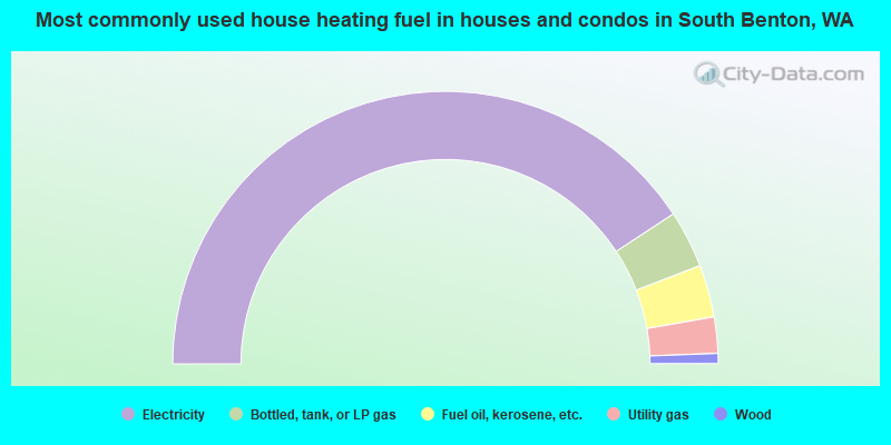
- 81.4%Electricity
- 6.8%Bottled, tank, or LP gas
- 6.2%Fuel oil, kerosene, etc.
- 4.3%Utility gas
- 1.2%Wood
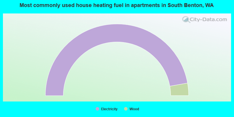
- 94.4%Electricity
- 5.6%Wood
South Benton compared to Washington state average:
- Median house value significantly below state average.
- Unemployed percentage significantly below state average.
- Black race population percentage significantly below state average.
- Hispanic race population percentage above state average.
- Foreign-born population percentage significantly below state average.
- Length of stay since moving in significantly above state average.
- Number of rooms per house significantly below state average.
- House age significantly below state average.
- Number of college students below state average.
- Percentage of population with a bachelor's degree or higher significantly below state average.
South Benton on our top lists:
- #82 on the list of "Top 101 cities with the largest percentage of mobile homes (200+ housing units)"
- #90 (99345) on the list of "Top 101 zip codes with the largest percentage of Ukrainian first ancestries"
- #19 on the list of "Top 101 counties with the largest number of people moving in compared to moving out (pop. 50,000+)"
- #29 on the list of "Top 101 counties with the highest average weight of females"
- #35 on the list of "Top 101 counties with the highest percentage of residents that keep firearms around their homes"
- #56 on the list of "Top 101 counties with the largest increase in the number of births per 1000 residents 2000-2006 to 2007-2013 (pop 50,000+)"
- #67 on the list of "Top 101 counties with the lowest percentage of residents that drank alcohol in the past 30 days"