Siler, Kentucky
Submit your own pictures of this place and show them to the world
- OSM Map
- General Map
- Google Map
- MSN Map

| Males: 1,167 | |
| Females: 1,154 |
| Median resident age: | 36.8 years |
| Kentucky median age: | 35.9 years |
Zip code: 40769
| Siler: | $30,207 |
| KY: | $59,341 |
Estimated per capita income in 2022: $15,485 (it was $8,747 in 2000)
Siler CCD income, earnings, and wages data
Estimated median house or condo value in 2022: $72,985 (it was $28,500 in 2000)
| Siler: | $72,985 |
| KY: | $196,300 |
Mean prices in 2022: all housing units: $141,900; detached houses: $157,411; townhouses or other attached units: $178,646; mobile homes: $82,371
Detailed information about poverty and poor residents in Siler, KY


- 2,14998.5%White alone
- 100.5%American Indian alone
- 100.5%Two or more races
- 100.5%Hispanic
- 10.05%Black alone
- 10.05%Asian alone

Races in Siler detailed stats: ancestries, foreign born residents, place of birth
According to our research of Kentucky and other state lists, there were 4 registered sex offenders living in Siler, Kentucky as of June 08, 2024.
The ratio of all residents to sex offenders in Siler is 580 to 1.
The ratio of registered sex offenders to all residents in this city is lower than the state average.
 Recent articles from our blog. Our writers, many of them Ph.D. graduates or candidates, create easy-to-read articles on a wide variety of topics.
Current Local Time: EST time zone
Land area: 64.7 square miles.
Population density: 36 people per square mile (very low).

| Siler CCD: | 0.7% ($199) |
| Kentucky: | 0.8% ($610) |
Nearest city with pop. 50,000+: Knoxville, TN  (50.9 miles , pop. 173,890).
Nearest city with pop. 200,000+: Fayette, KY (95.5 miles , pop. 260,512).
Nearest city with pop. 1,000,000+: Chicago, IL (406.1 miles , pop. 2,896,016).
Nearest cities:
), ), ), ), ), ), )Latitude: 36.71 N, Longitude: 83.99 W
Area code commonly used in this area: 606


| Here: | 4.4% |
| Kentucky: | 3.8% |

- Construction (9.1%)
- Educational services (8.8%)
- Mining, quarrying, oil & gas extraction (6.2%)
- Accommodation & food services (5.3%)
- Health care (5.1%)
- Plastics & rubber products (5.1%)
- Food & beverage stores (5.0%)

- Construction (13.8%)
- Mining, quarrying, oil & gas extraction (10.3%)
- Truck transportation (8.0%)
- Miscellaneous manufacturing (7.4%)
- Food & beverage stores (7.2%)
- Agriculture, forestry, fishing & hunting (5.3%)
- Accommodation & food services (4.2%)

- Educational services (20.6%)
- Plastics & rubber products (8.5%)
- Transportation equipment (7.7%)
- Health care (7.7%)
- Used merchandise, gift, novelty, souvenir, other miscellaneous stores (7.3%)
- Accommodation & food services (6.9%)
- Department & other general merchandise stores (4.5%)

- Assemblers and fabricators (8.3%)
- Other production occupations, including supervisors (7.7%)
- Driver/sales workers and truck drivers (7.4%)
- Laborers and material movers, hand (5.4%)
- Retail sales workers, except cashiers (5.0%)
- Metal workers and plastic workers (4.3%)
- Cooks and food preparation workers (4.2%)

- Driver/sales workers and truck drivers (12.2%)
- Other production occupations, including supervisors (9.5%)
- Carpenters (6.9%)
- Assemblers and fabricators (6.1%)
- Extraction workers (5.8%)
- Laborers and material movers, hand (5.8%)
- Metal workers and plastic workers (5.6%)

- Assemblers and fabricators (11.7%)
- Retail sales workers, except cashiers (10.5%)
- Building and grounds cleaning and maintenance occupations (8.5%)
- Other teachers, instructors, education, training, and library occupations (7.7%)
- Cooks and food preparation workers (6.5%)
- Textile, apparel, and furnishings workers (5.3%)
- Information and record clerks, except customer service representatives (4.9%)
Average climate in Siler, Kentucky
Based on data reported by over 4,000 weather stations


(lower is better)

Air Quality Index (AQI) level in 2023 was 80.8. This is about average.
| City: | 80.8 |
| U.S.: | 72.6 |

Carbon Monoxide (CO) [ppm] level in 2000 was 0.127. This is significantly better than average. Closest monitor was 15.7 miles away from the city center.
| City: | 0.127 |
| U.S.: | 0.251 |

Ozone [ppb] level in 2023 was 31.2. This is about average. Closest monitor was 15.7 miles away from the city center.
| City: | 31.2 |
| U.S.: | 33.3 |

Particulate Matter (PM2.5) [µg/m3] level in 2022 was 9.68. This is about average. Closest monitor was 15.7 miles away from the city center.
| City: | 9.68 |
| U.S.: | 8.11 |
Tornado activity:
Siler-area historical tornado activity is below Kentucky state average. It is 26% smaller than the overall U.S. average.
On 4/3/1974, a category F4 (max. wind speeds 207-260 mph) tornado 30.0 miles away from the Siler place center .
On 3/12/1967, a category F3 (max. wind speeds 158-206 mph) tornado 7.6 miles away from the place center .
Earthquake activity:
Siler-area historical earthquake activity is significantly above Kentucky state average. It is 74% greater than the overall U.S. average.On 7/27/1980 at 18:52:21, a magnitude 5.2 (5.1 MB, 4.7 MS, 5.0 UK, 5.2 UK, Class: Moderate, Intensity: VI - VII) earthquake occurred 103.6 miles away from Siler center
On 11/30/1973 at 07:48:41, a magnitude 4.7 (4.7 MB, 4.6 ML, Class: Light, Intensity: IV - V) earthquake occurred 62.9 miles away from the city center
On 8/9/2020 at 12:07:37, a magnitude 5.1 (5.1 MW, Depth: 4.7 mi) earthquake occurred 161.7 miles away from Siler center
On 4/18/2008 at 09:36:59, a magnitude 5.4 (5.1 MB, 4.8 MS, 5.4 MW, 5.2 MW) earthquake occurred 245.2 miles away from Siler center
On 9/7/1988 at 02:28:09, a magnitude 4.6 (4.5 MB, 4.6 LG) earthquake occurred 99.5 miles away from Siler center
On 8/23/2011 at 17:51:04, a magnitude 5.8 (5.8 MW, Depth: 3.7 mi) earthquake occurred 343.2 miles away from the city center
Magnitude types: regional Lg-wave magnitude (LG), body-wave magnitude (MB), local magnitude (ML), surface-wave magnitude (MS), moment magnitude (MW)
Natural disasters:
The number of natural disasters in Whitley County (24) is greater than the US average (15).Major Disasters (Presidential) Declared: 17
Emergencies Declared: 2
Causes of natural disasters: Floods: 14, Storms: 13, Mudslides: 6, Tornadoes: 6, Landslides: 5, Winter Storms: 4, Fires: 2, Winds: 2, Blizzard: 1, Freeze: 1, Hurricane: 1, Snow: 1, Snowfall: 1, Snowstorm: 1, Other: 1 (Note: some incidents may be assigned to more than one category).
Hospitals and medical centers near Siler:
- JELLICO COMMUNITY HOSPITAL Acute Care Hospitals (about 12 miles away; JELLICO, TN)
- BEECH TREE MANOR (Nursing Home, about 12 miles away; JELLICO, TN)
- SUNBELT HOMECARE (Home Health Center, about 12 miles away; JELLICO, TN)
- BARBOURVILLE HEALTH AND REHABILITATION CENTER (Nursing Home, about 13 miles away; BARBOURVILLE, KY)
- MIDDLESBORO HEALTH CARE FACILITY (Nursing Home, about 15 miles away; MIDDLESBORO, KY)
- CORBIN HEALTH AND REHABILITATION CENTER (Nursing Home, about 16 miles away; CORBIN, KY)
- THE HERITAGE (Nursing Home, about 16 miles away; CORBIN, KY)
Colleges/universities with over 2000 students nearest to Siler:
- University of the Cumberlands (about 10 miles; Williamsburg, KY; Full-time enrollment: 3,585)
- Lincoln Memorial University (about 21 miles; Harrogate, TN; FT enrollment: 3,706)
- Somerset Community College (about 43 miles; Somerset, KY; FT enrollment: 4,698)
- The University of Tennessee-Knoxville (about 53 miles; Knoxville, TN; FT enrollment: 25,483)
- Walters State Community College (about 54 miles; Morristown, TN; FT enrollment: 4,359)
- Pellissippi State Community College (about 54 miles; Knoxville, TN; FT enrollment: 7,271)
- Hazard Community and Technical College (about 58 miles; Hazard, KY; FT enrollment: 2,087)
Points of interest:
Notable locations in Siler: Polly Camp (A), Patterson Creek Volunteer Fire Department (B). Display/hide their locations on the map
Churches in Siler include: Locust Grove Church (A), Mossy Gap Church (B), Peace Memorial Church (C), Poplar Creek Church (D), Beech Bottom Church (E), Mulberry Church (F), Mount Pisgah Church (G). Display/hide their locations on the map
Cemeteries: Jones Cemetery (1), Partin Cemetery (2), Croley Cemetery (3), Goins Cemetery (4), Wells Cemetery (5), Lawson Cemetery (6), Siler Cemetery (7). Display/hide their locations on the map
Streams, rivers, and creeks: Bennett Branch (A), Doolin Branch (B), Davis Branch (C), Joe Branch (D), Little Patterson Creek (E), Coalstone Branch (F), Long Rocky Branch (G), Trace Branch (H), Poplar Creek (I). Display/hide their locations on the map
Park in Siler: The Big Oak (1). Display/hide its location on the map
| This place: | 2.4 people |
| Kentucky: | 2.5 people |
| This place: | 68.5% |
| Whole state: | 66.9% |
| This place: | 5.6% |
| Whole state: | 6.4% |
Likely homosexual households (counted as self-reported same-sex unmarried-partner households)
- Lesbian couples: 0.5% of all households
- Gay men: 0.4% of all households
| This place: | 37.3% |
| Whole state: | 15.8% |
| This place: | 13.3% |
| Whole state: | 6.6% |
For population 15 years and over in Siler:

- Never married: 19.3%
- Now married: 60.6%
- Separated: 2.1%
- Widowed: 9.4%
- Divorced: 10.8%
For population 25 years and over in Siler:
- High school or higher: 49.2%
- Bachelor's degree or higher: 3.1%
- Graduate or professional degree: 0.5%
- Unemployed: 12.5%
- Mean travel time to work (commute): 34.5 minutes


| Here: | 18.1 |
| Kentucky average: | 13.8 |

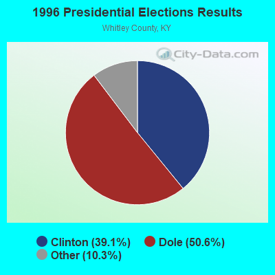
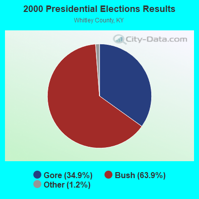
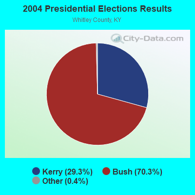
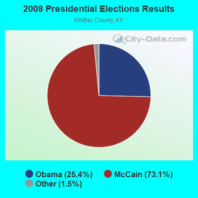
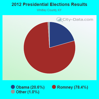
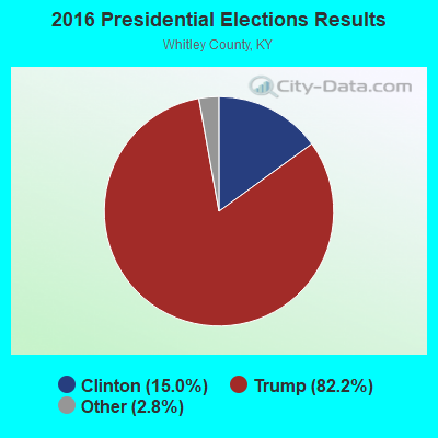
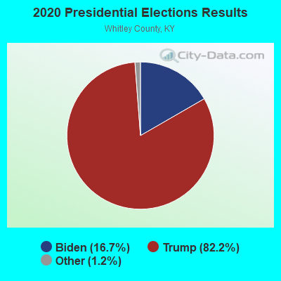
Graphs represent county-level data. Detailed 2008 Election Results
Religion statistics for Siler, KY (based on Whitley County data)
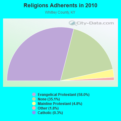
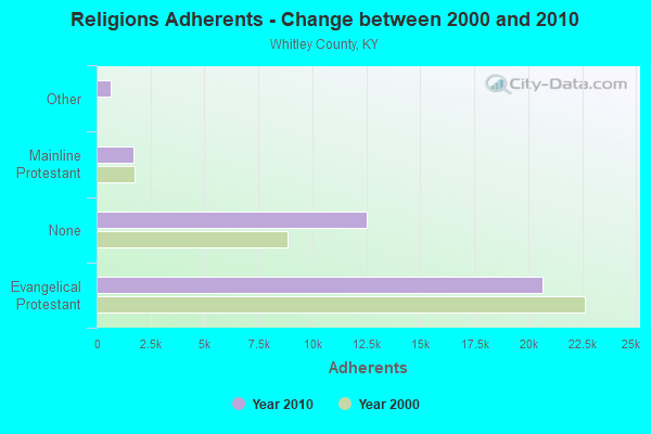
| Religion | Adherents | Congregations |
|---|---|---|
| Evangelical Protestant | 20,685 | 78 |
| Mainline Protestant | 1,697 | 7 |
| Other | 652 | 3 |
| Catholic | 92 | 2 |
| None | 12,511 | - |
Food Environment Statistics:
| Here: | 2.35 / 10,000 pop. |
| Kentucky: | 2.19 / 10,000 pop. |
| Whitley County: | 0.26 / 10,000 pop. |
| State: | 0.25 / 10,000 pop. |
| Whitley County: | 1.04 / 10,000 pop. |
| State: | 0.74 / 10,000 pop. |
| Here: | 5.22 / 10,000 pop. |
| Kentucky: | 4.36 / 10,000 pop. |
| Whitley County: | 3.39 / 10,000 pop. |
| Kentucky: | 5.74 / 10,000 pop. |
| This county: | 13.9% |
| Kentucky: | 11.0% |
| This county: | 30.9% |
| Kentucky: | 30.0% |
| This county: | 20.7% |
| Kentucky: | 15.9% |
Strongest AM radio stations in Siler:
- WEKC (710 AM; daytime; 4 kW; WILLIAMSBURG, KY; Owner: GERALD PARKS)
- WKVL (850 AM; daytime; 50 kW; KNOXVILLE, TN; Owner: HORNE RADIO, LLC)
- WEZJ (1440 AM; 2 kW; WILLIAMSBURG, KY; Owner: WHITLEY BROADCASTING CO., INC.)
- WMIK (560 AM; 2 kW; MIDDLESBORO, KY; Owner: GATEWAY BROADCASTING, INC.)
- WKDP (1330 AM; 5 kW; CORBIN, KY; Owner: EUBANKS BROADCASTING, INC.)
- WYWY (950 AM; 1 kW; BARBOURVILLE, KY; Owner: BARBOURVILLE-COMMNITY BROADC/G CO IN)
- WCTT (680 AM; 1 kW; CORBIN, KY; Owner: ENCORE COMMUNICATIONS, INC)
- WNOX (990 AM; 10 kW; KNOXVILLE, TN)
- WQBB (1040 AM; daytime; 10 kW; POWELL, TN; Owner: JOURNAL BROADCAST CORPORATION)
- WJJT (1540 AM; 1 kW; JELLICO, TN; Owner: DOUGLAS BROADCASTING CORPORATION)
- WKLB (1290 AM; 5 kW; MANCHESTER, KY; Owner: BARKER BROADCASTING COMPANY, INC.)
- WFGW (1010 AM; 50 kW; BLACK MOUNTAIN, NC; Owner: BLUE RIDGE BROADCASTING CORP.)
- WFSR (970 AM; 5 kW; HARLAN, KY; Owner: EASTERN BROADCASTING COMPAY)
Strongest FM radio stations in Siler:
- WMIK-FM (92.7 FM; MIDDLESBORO, KY; Owner: GATEWAY BROADCASTING, INC.)
- WEKX (102.7 FM; JELLICO, TN; Owner: WHITLEY BROADCASTING CO., INC.)
- WEZJ-FM (104.3 FM; WILLIAMSBURG, KY; Owner: WHITLEY BROADCASTING CO., INC.)
- WRIL (106.3 FM; PINEVILLE, KY; Owner: PINE HILLS BROADCASTING, INC.)
- WKDP-FM (99.5 FM; CORBIN, KY; Owner: EUBANKS BROADCASTING, INC.)
- WDVX (89.9 FM; CLINTON, TN; Owner: CUMBERLAND COMMUNITIES COMMUNI CORP.)
- WCTT-FM (107.3 FM; CORBIN, KY; Owner: ENCORE COMMUNICATIONS, INC.)
- WCTU (105.9 FM; TAZEWELL, TN; Owner: STAIR COMPANY, INC)
- WKKQ (96.1 FM; BARBOURVILLE, KY; Owner: BARBOURVILLE COMMUNITY B/NG CO.INC.)
- WIMZ-FM (103.5 FM; KNOXVILLE, TN; Owner: SOUTH CENTRAL COMM., CORP.)
- WOKI-FM (100.3 FM; OAK RIDGE, TN; Owner: OAK RIDGE FM, INC.)
- WUOT (91.9 FM; KNOXVILLE, TN; Owner: UNIVERSITY OF TENNESSEE)
- WSEH (102.7 FM; CUMBERLAND, KY; Owner: CUMBERLAND CITY BROADCASTING, INC.)
- WTUK (105.1 FM; HARLAN, KY; Owner: EASTERN BROADCASTING COMPANY)
- WJXB-FM (97.5 FM; KNOXVILLE, TN; Owner: SOUTH CENTRAL COMMUNICATIONS CORP.)
- WYGE (92.3 FM; LONDON, KY; Owner: ETHEL HUFF BROADCASTING, LLC)
- WVCT (91.5 FM; KEAVY, KY; Owner: VICTORY TRAINING SCHOOL CORP.)
- WQLA-FM (104.9 FM; LA FOLLETTE, TN; Owner: LAFOLLETTE BROADCASTERS, INC.)
- WWLT (103.1 FM; MANCHESTER, KY; Owner: VERNON R. BALDWIN, INC.)
- WLMU (91.3 FM; HARROGATE, TN; Owner: LINCOLN MEMORIAL UNIVERSITY)
TV broadcast stations around Siler:
- WKOP-TV (Channel 15; KNOXVILLE, TN; Owner: EAST TENNESSEE PUBLIC COMMUNICATIONS CORP.)
- WVLT-TV (Channel 8; KNOXVILLE, TN; Owner: WVLT LICENSEE CORP.)
- WBIR-TV (Channel 10; KNOXVILLE, TN; Owner: GANNETT PACIFIC CORPORATION)
- WATE-TV (Channel 6; KNOXVILLE, TN; Owner: WATE, G.P.)
- WTNZ (Channel 43; KNOXVILLE, TN; Owner: RAYCOM AMERICA, INC.)
- WVTN-LP (Channel 48; CORBIN, KY; Owner: VICTORY TRAINING SCHOOL CORP.)
- WPXK (Channel 54; JELLICO, TN; Owner: PAXSON KNOXVILLE LICENSE, INC.)
- W33BK (Channel 33; CORBIN, KY; Owner: TRINITY BROADCASTING NETWORK)
- W39CK (Channel 20; CORBIN, KY; Owner: DEREK RAY EUBANKS)
FCC Registered Antenna Towers:
10 (See the full list of FCC Registered Antenna Towers in Siler)FCC Registered Broadcast Land Mobile Towers:
1- Lat: 36.724111 Lon: -83.977083, Call Sign: WQHK631,
Assigned Frequencies: 72.2000 MHz, Grant Date: 08/23/2007, Expiration Date: 08/23/2017, Cancellation Date: 09/25/2014, Certifier: Kenneth Powell, Registrant: Primex Wireless Inc., 965 Wells Street, Lake Geneva, WI 53147, Phone: (800) 537-0464
FCC Registered Amateur Radio Licenses:
1- Call Sign: WA4CNB, Grant Date: 07/05/1988, Expiration Date: 07/05/1998, Cancellation Date: 07/06/2000, Registrant: John W Mc Mahan Jr, Hc 89 Box 765, Siler, KY 40763

- 52.9%Electricity
- 19.6%Bottled, tank, or LP gas
- 12.7%Coal or coke
- 7.0%Utility gas
- 5.0%Fuel oil, kerosene, etc.
- 2.8%Wood

- 36.0%Electricity
- 25.3%Utility gas
- 14.5%Coal or coke
- 11.3%Bottled, tank, or LP gas
- 8.6%Fuel oil, kerosene, etc.
- 4.3%Wood
Siler compared to Kentucky state average:
- Median household income below state average.
- Median house value significantly below state average.
- Black race population percentage significantly below state average.
- Hispanic race population percentage significantly below state average.
- Median age below state average.
- Foreign-born population percentage significantly below state average.
- Length of stay since moving in significantly above state average.
- Number of rooms per house significantly below state average.
- House age significantly below state average.
- Number of college students below state average.
- Percentage of population with a bachelor's degree or higher significantly below state average.