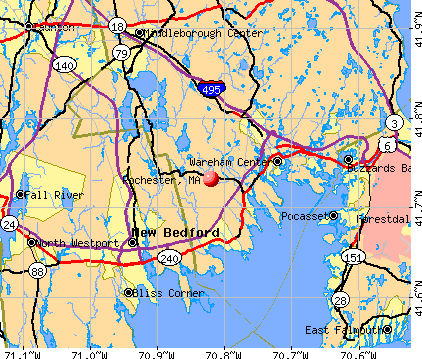
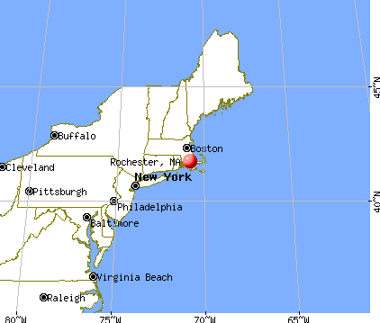
Rochester, Massachusetts
Submit your own pictures of this town and show them to the world
- OSM Map
- General Map
- Google Map
- MSN Map
Population change since 2000: +14.2%
 |
| Males: 2,638 | |
| Females: 2,594 |
| Median resident age: | 43.3 years |
| Massachusetts median age: | 39.2 years |
Zip codes: 02770.
| Rochester: | $117,409 |
| MA: | $94,488 |
Estimated per capita income in 2022: $53,816 (it was $24,630 in 2000)
Rochester town income, earnings, and wages data
Estimated median house or condo value in 2022: $575,511 (it was $184,800 in 2000)
| Rochester: | $575,511 |
| MA: | $534,700 |
Mean prices in 2022: all housing units: $585,203; detached houses: $620,100; townhouses or other attached units: $487,972; in 2-unit structures: $464,355; in 3-to-4-unit structures: $429,583; in 5-or-more-unit structures: $438,441; mobile homes: $207,706; occupied boats, rvs, vans, etc.: $17,153
Detailed information about poverty and poor residents in Rochester, MA
Compare current foreclosures near Rochester, MA:
| Photo | Address | Area | Beds / Baths | Price | Details |
|---|---|---|---|---|---|

|
#1
Pine St
Rochester, MA 02770
|
2,020 sq. feet
|
2 baths 3 beds |
show details | |

|
#2
Hartley Rd
Rochester, MA 02770
|
1,356 sq. feet
|
1 baths 4 beds |
show details | |

|
#3
Mendell Rd
Rochester, MA 02770
|
1,152 sq. feet
|
1 baths 2 beds |
show details | |

|
#4
Somerset Ave
Taunton, MA 02780
|
3,196 sq. feet
|
3 baths 4 beds |
$754,900
|
show details |

|
#5
County St
East Taunton, MA 02718
|
1,157 sq. feet
|
1 baths 1 beds |
$219,900
|
show details |

|
#6
Neck Rd
Rochester, MA 02770
|
- sq. feet
|
- baths - beds |
show details | |

|
#7
Peckham St
New Bedford, MA 02746
|
3,089 sq. feet
|
3 baths 9 beds |
show details | |

|
#8
Bliss St
Fall River, MA 02720
|
1,220 sq. feet
|
2 baths 2 beds |
show details | |

|
#9
Lakewood Cir
Sagamore Beach, MA 02562
|
2,688 sq. feet
|
3 baths 5 beds |
show details | |

|
#10
South St
Bridgewater, MA 02324
|
2,817 sq. feet
|
2 baths 3 beds |
show details |
| Photo | Address | Area | Beds / Baths | Price | Details |
|---|---|---|---|---|---|

|
#11
Remington Ln
Plymouth, MA 02360
|
1,758 sq. feet
|
3 baths 3 beds |
show details | |

|
#12
Onset Ave # G
Buzzards Bay, MA 02532
|
1,654 sq. feet
|
2 baths 2 beds |
show details | |

|
#13
Sanderson Dr
Plymouth, MA 02360
|
2,474 sq. feet
|
3 baths 2 beds |
show details | |

|
#14
Ocean Mdws
Fairhaven, MA 02719
|
977 sq. feet
|
1 baths 2 beds |
show details | |

|
#15
Ivy Ln
Lakeville, MA 02347
|
496 sq. feet
|
1 baths 1 beds |
show details | |

|
#16
Eugenia St
New Bedford, MA 02745
|
2,360 sq. feet
|
2 baths 6 beds |
show details | |

|
#17
Cornell Cir
South Dartmouth, MA 02748
|
1,050 sq. feet
|
1 baths 3 beds |
show details | |

|
#18
Phillips Rd
New Bedford, MA 02745
|
1,188 sq. feet
|
2 baths 3 beds |
show details | |

|
#19
Wareham St
Middleboro, MA 02346
|
1,060 sq. feet
|
1 baths 3 beds |
show details | |

|
#20
Liberty St
Plymouth, MA 02360
|
1,054 sq. feet
|
2 baths 2 beds |
show details |
| Photo | Address | Area | Beds / Baths | Price | Details |
|---|---|---|---|---|---|

|
#21
Mill St
New Bedford, MA 02740
|
1,542 sq. feet
|
1 baths 3 beds |
show details | |

|
#22
Standish Ave
Plymouth, MA 02360
|
1,756 sq. feet
|
1 baths 3 beds |
show details | |

|
#23
Homestead Ave
Acushnet, MA 02743
|
936 sq. feet
|
1 baths 3 beds |
show details | |

|
#24
Vera Dr
Bridgewater, MA 02324
|
1,836 sq. feet
|
2 baths 3 beds |
show details | |

|
#25
Terrace Way
Middleboro, MA 02346
|
972 sq. feet
|
1 baths 2 beds |
show details | |

|
#26
Wingold St
Fall River, MA 02720
|
1,028 sq. feet
|
1 baths 2 beds |
show details | |

|
#27
Wareham St
Middleboro, MA 02346
|
912 sq. feet
|
1 baths 2 beds |
show details | |

|
#28
Flintlock Ln
Sagamore Beach, MA 02562
|
1,372 sq. feet
|
2 baths 3 beds |
show details | |

|
#29
Siasconset Dr
Sagamore Beach, MA 02562
|
1,428 sq. feet
|
2 baths 4 beds |
show details | |

|
#30
Lowell St
New Bedford, MA 02745
|
1,744 sq. feet
|
3 baths 3 beds |
show details |
| Photo | Address | Area | Beds / Baths | Price | Details |
|---|---|---|---|---|---|

|
#31
Agawam Lake Shore Dr
Wareham, MA 02571
|
936 sq. feet
|
1 baths 3 beds |
show details | |

|
#32
Ashland St
Taunton, MA 02780
|
1,680 sq. feet
|
2 baths 4 beds |
show details | |

|
#33
1st St
Taunton, MA 02780
|
1,696 sq. feet
|
1 baths 3 beds |
show details | |

|
#34
Briar Path Way
Carver, MA 02330
|
1,654 sq. feet
|
2 baths 4 beds |
show details | |

|
#35
Somerset Ave
Taunton, MA 02780
|
1,251 sq. feet
|
2 baths 4 beds |
show details | |

|
#36
Church St Apt 71
New Bedford, MA 02745
|
759 sq. feet
|
1 baths 2 beds |
show details | |

|
#37
Lydon Ln # A1
Halifax, MA 02338
|
974 sq. feet
|
2 baths 2 beds |
show details | |

|
#38
Day St
Fairhaven, MA 02719
|
936 sq. feet
|
1 baths 3 beds |
show details | |

|
#39
Benton St
Middleboro, MA 02346
|
1,210 sq. feet
|
1 baths 3 beds |
show details | |

|
#40
Plymouth St
Middleboro, MA 02346
|
1,510 sq. feet
|
2 baths 2 beds |
show details |
| Photo | Address | Area | Beds / Baths | Price | Details |
|---|---|---|---|---|---|

|
#41
Liberty St
New Bedford, MA 02740
|
2,108 sq. feet
|
2 baths 6 beds |
show details | |

|
#42
Oak St
New Bedford, MA 02740
|
1,460 sq. feet
|
2 baths 3 beds |
show details | |

|
#43
Wilbur St
New Bedford, MA 02740
|
1,596 sq. feet
|
2 baths 4 beds |
show details | |

|
#44
Bedford St
New Bedford, MA 02740
|
1,658 sq. feet
|
2 baths 3 beds |
show details | |

|
#45
Cottage St
New Bedford, MA 02740
|
2,770 sq. feet
|
2 baths 7 beds |
show details | |

|
#46
Powhattan Dr
East Taunton, MA 02718
|
1,632 sq. feet
|
1 baths 3 beds |
show details | |

|
#47
Seaview Ave
Fairhaven, MA 02719
|
864 sq. feet
|
1 baths 3 beds |
show details | |

|
#48
Puritan Ave
East Wareham, MA 02538
|
1,424 sq. feet
|
1 baths 3 beds |
show details | |

|
#49
Plymouth Ave
East Wareham, MA 02538
|
1,064 sq. feet
|
2 baths 2 beds |
show details | |

|
Check over 1 million property listings on Foreclosure.com!
|
browse all offers | |||

- 4,97395.0%White alone
- 871.7%Two or more races
- 511.0%Black alone
- 440.8%Other race alone
- 400.8%Hispanic
- 330.6%Asian alone
- 40.08%American Indian alone

Races in Rochester detailed stats: ancestries, foreign born residents, place of birth
Type |
2009 |
2010 |
2011 |
2012 |
2013 |
2014 |
2015 |
2016 |
2017 |
2018 |
2019 |
2020 |
2021 |
2022 |
|---|---|---|---|---|---|---|---|---|---|---|---|---|---|---|
| Murders (per 100,000) | 0 (0.0) | 0 (0.0) | 0 (0.0) | 0 (0.0) | 0 (0.0) | 0 (0.0) | 0 (0.0) | 0 (0.0) | 0 (0.0) | 0 (0.0) | 0 (0.0) | 0 (0.0) | 0 (0.0) | 0 (0.0) |
| Rapes (per 100,000) | 1 (18.7) | 0 (0.0) | 1 (19.0) | 0 (0.0) | 1 (18.6) | 0 (0.0) | 1 (18.2) | 0 (0.0) | 0 (0.0) | 0 (0.0) | 5 (88.7) | 1 (16.9) | 0 (0.0) | 2 (33.0) |
| Robberies (per 100,000) | 1 (18.7) | 0 (0.0) | 3 (57.0) | 1 (18.8) | 0 (0.0) | 1 (18.4) | 0 (0.0) | 1 (18.1) | 0 (0.0) | 1 (17.8) | 0 (0.0) | 0 (0.0) | 3 (49.4) | 0 (0.0) |
| Assaults (per 100,000) | 8 (149.6) | 1 (19.1) | 6 (114.0) | 5 (94.2) | 2 (37.3) | 2 (36.8) | 3 (54.6) | 13 (235.4) | 9 (160.9) | 6 (106.7) | 3 (53.2) | 3 (50.6) | 0 (0.0) | 3 (49.5) |
| Burglaries (per 100,000) | 20 (374.1) | 22 (420.5) | 15 (285.0) | 23 (433.3) | 18 (335.4) | 13 (239.3) | 11 (200.1) | 11 (199.2) | 13 (232.4) | 3 (53.4) | 10 (177.5) | 2 (33.7) | 4 (65.9) | 4 (66.1) |
| Thefts (per 100,000) | 28 (523.8) | 32 (611.6) | 42 (797.9) | 37 (697.1) | 28 (521.7) | 27 (497.1) | 18 (327.5) | 21 (380.3) | 25 (447.0) | 20 (355.7) | 14 (248.5) | 10 (168.5) | 10 (164.8) | 32 (528.4) |
| Auto thefts (per 100,000) | 6 (112.2) | 0 (0.0) | 3 (57.0) | 2 (37.7) | 4 (74.5) | 1 (18.4) | 1 (18.2) | 1 (18.1) | 2 (35.8) | 2 (35.6) | 2 (35.5) | 1 (16.9) | 1 (16.5) | 3 (49.5) |
| Arson (per 100,000) | 1 (18.7) | 3 (57.3) | 0 (0.0) | 0 (0.0) | 0 (0.0) | 0 (0.0) | 0 (0.0) | 0 (0.0) | 0 (0.0) | 0 (0.0) | 0 (0.0) | 0 (0.0) | 0 (0.0) | 0 (0.0) |
| City-Data.com crime index | 106.6 | 57.7 | 111.5 | 85.7 | 72.7 | 51.0 | 54.0 | 83.1 | 69.2 | 47.5 | 106.9 | 34.0 | 27.4 | 66.1 |
The City-Data.com crime index weighs serious crimes and violent crimes more heavily. Higher means more crime, U.S. average is 246.1. It adjusts for the number of visitors and daily workers commuting into cities.

Crime rate in Rochester detailed stats: murders, rapes, robberies, assaults, burglaries, thefts, arson
Full-time law enforcement employees in 2021, including police officers: 13 (12 officers - 11 male; 1 female).
| Officers per 1,000 residents here: | 1.98 |
| Massachusetts average: | 2.53 |
 Recent articles from our blog. Our writers, many of them Ph.D. graduates or candidates, create easy-to-read articles on a wide variety of topics.

 | The worst winter in Massachusetts. Is the weather bothering you? (285 replies) |
| Oklahoma to (likely Western) Massachusetts - Beginning Research (274 replies) |
| Towns within 495 with nice walkable downtowns and good schools (205 replies) |
| Boston (the city) Has Lost Its Allure for Me (141 replies) |
| Drownings in the area (148 replies) |
| Most North “hood” in the northeast (181 replies) |
Latest news from Rochester, MA collected exclusively by city-data.com from local newspapers, TV, and radio stations
Ancestries: English (25.2%), Irish (18.0%), Portuguese (17.2%), French (14.7%), French Canadian (10.5%), Polish (9.3%).
Current Local Time: EST time zone
Incorporated in 1686
Elevation: 29 feet
Land area: 33.9 square miles.
Population density: 154 people per square mile (very low).
115 residents are foreign born (1.9% Europe, 0.3% Asia, 0.3% Latin America).
| This town: | 2.5% |
| Massachusetts: | 12.2% |
| Rochester town: | 1.1% ($2,071) |
| Massachusetts: | 1.3% ($2,336) |
Nearest city with pop. 50,000+: New Bedford, MA  (9.7 miles , pop. 93,768).
Nearest city with pop. 200,000+: Boston, MA (40.5 miles , pop. 589,141).
Nearest city with pop. 1,000,000+: Bronx, NY (170.5 miles , pop. 1,332,650).
Nearest cities:
), ), ), ), ), Latitude: 41.77 N, Longitude: 70.83 W
Area codes: 508, 774


Single-family new house construction building permits:
- 2022: 24 buildings, average cost: $250,900
- 2021: 32 buildings, average cost: $263,600
- 2020: 15 buildings, average cost: $389,800
- 2019: 19 buildings, average cost: $245,400
- 2018: 23 buildings, average cost: $278,900
- 2017: 21 buildings, average cost: $258,000
- 2016: 20 buildings, average cost: $277,200
- 2015: 12 buildings, average cost: $269,800
- 2014: 17 buildings, average cost: $228,500
- 2013: 18 buildings, average cost: $239,400
- 2012: 14 buildings, average cost: $227,700
- 2011: 8 buildings, average cost: $216,300
- 2010: 21 buildings, average cost: $341,900
- 2009: 11 buildings, average cost: $294,700
- 2008: 6 buildings, average cost: $309,100
- 2007: 13 buildings, average cost: $386,800
- 2006: 15 buildings, average cost: $369,100
- 2005: 55 buildings, average cost: $299,100
- 2004: 52 buildings, average cost: $253,800
- 2003: 54 buildings, average cost: $306,800
- 2002: 56 buildings, average cost: $333,400
- 2001: 39 buildings, average cost: $220,300
- 2000: 62 buildings, average cost: $133,100
- 1999: 40 buildings, average cost: $139,300
- 1998: 53 buildings, average cost: $138,600
- 1997: 22 buildings, average cost: $119,500


| Here: | 2.9% |
| Massachusetts: | 3.5% |


- Health care (11.2%)
- Educational services (9.3%)
- Construction (7.2%)
- Public administration (5.9%)
- Professional, scientific, technical services (4.7%)
- Finance & insurance (3.7%)
- Accommodation & food services (3.3%)

- Construction (11.9%)
- Public administration (8.8%)
- Metal & metal products (5.7%)
- Educational services (5.3%)
- Professional, scientific, technical services (4.9%)
- Health care (4.6%)
- Agriculture, forestry, fishing & hunting (4.1%)

- Health care (18.2%)
- Educational services (13.7%)
- Finance & insurance (5.8%)
- Social assistance (5.4%)
- Accommodation & food services (5.2%)
- Professional, scientific, technical services (4.5%)
- Department & other general merchandise stores (3.9%)

- Other management occupations, except farmers and farm managers (7.8%)
- Other office and administrative support workers, including supervisors (5.1%)
- Preschool, kindergarten, elementary, and middle school teachers (3.9%)
- Electrical equipment mechanics and other installation, maintenance, and repair workers, including supervisors (3.8%)
- Sales representatives, services, wholesale and manufacturing (3.2%)
- Other production occupations, including supervisors (3.1%)
- Other sales and related occupations, including supervisors (3.0%)

- Other management occupations, except farmers and farm managers (10.2%)
- Electrical equipment mechanics and other installation, maintenance, and repair workers, including supervisors (7.4%)
- Other office and administrative support workers, including supervisors (4.6%)
- Law enforcement workers, including supervisors (4.6%)
- Engineers (3.8%)
- Metal workers and plastic workers (3.5%)
- Other sales and related occupations, including supervisors (3.4%)

- Preschool, kindergarten, elementary, and middle school teachers (6.7%)
- Other office and administrative support workers, including supervisors (5.6%)
- Other management occupations, except farmers and farm managers (5.2%)
- Secretaries and administrative assistants (4.6%)
- Retail sales workers, except cashiers (4.4%)
- Sales representatives, services, wholesale and manufacturing (4.0%)
- Registered nurses (3.8%)
Average climate in Rochester, Massachusetts
Based on data reported by over 4,000 weather stations


(lower is better)

Air Quality Index (AQI) level in 2022 was 64.1. This is about average.
| City: | 64.1 |
| U.S.: | 72.6 |


Ozone [ppb] level in 2022 was 30.4. This is about average. Closest monitor was 9.2 miles away from the city center.
| City: | 30.4 |
| U.S.: | 33.3 |

Particulate Matter (PM2.5) [µg/m3] level in 2022 was 8.70. This is about average. Closest monitor was 10.9 miles away from the city center.
| City: | 8.70 |
| U.S.: | 8.11 |
Tornado activity:
Rochester-area historical tornado activity is significantly below Massachusetts state average. It is 71% smaller than the overall U.S. average.
On 6/9/1953, a category F3 (max. wind speeds 158-206 mph) tornado 27.2 miles away from the Rochester town center injured 17 people and caused between $500,000 and $5,000,000 in damages.
On 6/9/1953, a category F4 (max. wind speeds 207-260 mph) tornado 51.1 miles away from the town center killed 90 people and injured 1228 people and caused between $50,000,000 and $500,000,000 in damages.
Earthquake activity:
Rochester-area historical earthquake activity is significantly above Massachusetts state average. It is 75% smaller than the overall U.S. average.On 10/7/1983 at 10:18:46, a magnitude 5.3 (5.1 MB, 5.3 LG, 5.1 ML, Class: Moderate, Intensity: VI - VII) earthquake occurred 233.5 miles away from the city center
On 4/20/2002 at 10:50:47, a magnitude 5.3 (5.3 ML, Depth: 3.0 mi) earthquake occurred 238.6 miles away from the city center
On 1/19/1982 at 00:14:42, a magnitude 4.7 (4.5 MB, 4.7 MD, 4.5 LG, Class: Light, Intensity: IV - V) earthquake occurred 126.0 miles away from the city center
On 10/16/2012 at 23:12:25, a magnitude 4.7 (4.7 ML, Depth: 10.0 mi) earthquake occurred 126.8 miles away from Rochester center
On 4/20/2002 at 10:50:47, a magnitude 5.2 (5.2 MB, 4.2 MS, 5.2 MW, 5.0 MW) earthquake occurred 237.9 miles away from Rochester center
On 8/22/1992 at 12:20:32, a magnitude 4.8 (4.8 MB, 3.8 MS, 4.7 LG, Depth: 6.2 mi) earthquake occurred 186.1 miles away from the city center
Magnitude types: regional Lg-wave magnitude (LG), body-wave magnitude (MB), duration magnitude (MD), local magnitude (ML), surface-wave magnitude (MS), moment magnitude (MW)
Natural disasters:
The number of natural disasters in Plymouth County (26) is a lot greater than the US average (15).Major Disasters (Presidential) Declared: 17
Emergencies Declared: 9
Causes of natural disasters: Floods: 11, Storms: 9, Hurricanes: 7, Snows: 3, Snowstorms: 3, Blizzards: 2, Winter Storms: 2, Heavy Rain: 1, Snowfall: 1, Tropical Storm: 1, Wind: 1 (Note: some incidents may be assigned to more than one category).

Hospitals and medical centers near Rochester:
- SIPPICAN HEALTHCARE CENTER (Nursing Home, about 5 miles away; MARION, MA)
- ISLAND TERRACE NURSING HOME (Nursing Home, about 5 miles away; LAKEVILLE, MA)
- TREMONT HEALTH CARE CENTER (Nursing Home, about 6 miles away; WAREHAM, MA)
- HOSPICE SERVICES OF MASSACHUSETTS (Hospital, about 6 miles away; WAREHAM, MA)
- NEMASKET HEALTHCARE CENTER (Nursing Home, about 6 miles away; MIDDLEBOROUGH, MA)
- TCU-TOBEY HOSPITAL (Nursing Home, about 6 miles away; WAREHAM, MA)
- LIGHTHOUSE HOSPICE ASSOCIATION, INC (Hospital, about 7 miles away; WAREHAM, MA)
located in Rochester:
Operable nuclear power plant near Rochester:
- 16 miles: Pilgrim in Plymouth, MA.
Colleges/universities with over 2000 students nearest to Rochester:
- University of Massachusetts-Dartmouth (about 14 miles; North Dartmouth, MA; Full-time enrollment: 7,545)
- Bristol Community College (about 16 miles; Fall River, MA; FT enrollment: 5,707)
- Bridgewater State University (about 17 miles; Bridgewater, MA; FT enrollment: 9,802)
- Massasoit Community College (about 23 miles; Brockton, MA; FT enrollment: 5,442)
- Roger Williams University (about 24 miles; Bristol, RI; FT enrollment: 4,375)
- Stonehill College (about 24 miles; Easton, MA; FT enrollment: 2,563)
- Cape Cod Community College (about 26 miles; West Barnstable, MA; FT enrollment: 2,491)
Biggest public high schools in Rochester:
- BOSTON LATIN ACADEMY (Students: 1,742, Location: 205 TOWNSEND STREET, Grades: 7-12)
- JEREMIAH E BURKE HIGH (Students: 743, Location: 60 WASHINGTON STREET, Grades: 9-12)
- COMMUNITY ACADEMY OF SCIENCE AND HEALTH (Students: 365, Location: 11 CHARLES STREET, Grades: 9-12)
- TECHBOSTON ACADEMY (Students: 360, Location: 9 PEACEVALE ROAD, Grades: 6-12)
- BOSTON INTERNATIONAL HIGH SCHOOL (Students: 146, Location: 100 MAXWELL ST, Grades: 9-12)
- BOSTON COLLEGIATE CHARTER SCHOOL (Location: 11 MAYHEW STREET, Grades: 5-12, Charter school)
- CODMAN ACADEMY CHARTER PUBLIC SCHOOL (Location: 637 WASHINGTON STREET, Grades: PK-12, Charter school)
- DEARBORN (Location: 60 WASHINGTON ST, Grades: 6-10)
- DR. WILLIAM HENDERSON UPPER (Location: 18 CROFTLAND AV, Grades: 5-11)
- DORCHESTER ACADEMY (Location: 11 CHARLES ST, Grades: 9-12)
Private high schools in Rochester:
Biggest public elementary/middle schools in Rochester:
- RICHARD J MURPHY (Students: 924, Location: 1 WORRELL STREET, Grades: PK-8)
- JOHN W MCCORMACK (Students: 675, Location: 315 MT VERNON STREET, Grades: 6-8)
- MATHER (Students: 542, Location: 24 PARISH STREET, Grades: PK-5)
- PAUL A DEVER (Students: 453, Location: 325 MT VERNON STREET, Grades: PK-5)
- WILLIAM MONROE TROTTER (Students: 452, Location: 135 HUMBOLDT AVENUE, Grades: PK-6)
- NEIGHBORHOOD HOUSE CHARTER SCHOOL (Students: 384, Location: 21 QUEEN STREET, Grades: PK-8, Charter school)
- SARAH GREENWOOD (Students: 356, Location: 189 GLENWAY STREET, Grades: PK-8)
- WILLIAM E RUSSELL (Students: 331, Location: 750 COLUMBIA ROAD, Grades: PK-5)
- JOHN WINTHROP (Students: 301, Location: 35 BROOKFORD STREET, Grades: PK-5)
- EDWARD EVERETT (Students: 267, Location: 71 PLEASANT STREET, Grades: PK-5)
Private elementary/middle schools in Rochester:
- POPE JOHN PAUL II CATHOLIC ACADEMY NEPONSET CAMPUS (Students: 426, Location: 239 NEPONSET AVE, Grades: PK-8)
- POPE JOHN PAUL II CATHOLIC ACADEMY COLUMBIA CAMPUS (Students: 395, Location: 790 COLUMBIA RD, Grades: PK-8)
- MOTHER CAROLINE ACADEMY & EDUCATION CENTER (Students: 54, Location: 515 BLUE HILL AVE, Grades: 5-8, Girls only)
Library in Rochester:
Points of interest:
Notable locations in Rochester: Rochester Golf Course (A), Rochester Fire Department Ambulance Service (B), Rochester Fire Department (C), Rochester Town Hall (D), Joseph H Plumb Memorial Library (E). Display/hide their locations on the map
Churches in Rochester include: Saint Rose of Lima Church (A), First Congregational Church (B), East Rochester Church (C). Display/hide their locations on the map
Cemeteries: Union Cemetery (1), Hillside Cemetery (2), Ashley Cemetery (3). Display/hide their locations on the map
Lakes, reservoirs, and swamps: Giffords Pond (A), Snows Pond (B), Snipatuit Pond (C), Harley Millpond (D), Leonards Pond (E), Mill Pond (F), Marys Pond (G), Long Pond (H). Display/hide their locations on the map
Streams, rivers, and creeks: Black Brook (A), Snipatuit Brook (B), West Branch Sippican River (C), Sherman Brook (D), Doggett Brook (E), Cedar Swamp Brook (F), East Branch Sippican River (G). Display/hide their locations on the map
Parks in Rochester include: Rochester Wildlife Management Area (1), Camp Snipatuit (2). Display/hide their locations on the map
Tourist attraction: T & A Amusements (Amusement & Theme Parks; 172 Pierce Street) (1). Display/hide its approximate location on the map
Birthplace of: Joseph Bates (Adventist) - Sailor, Timothy Ruggles - Politician, Jonathan Haskell - Acting Adjutant General and acting Inspector General of the Army in 1796.
| This town: | 2.9 people |
| Massachusetts: | 2.5 people |
| This town: | 81.4% |
| Whole state: | 63.0% |
| This town: | 5.4% |
| Whole state: | 7.0% |
Likely homosexual households (counted as self-reported same-sex unmarried-partner households)
- Lesbian couples: 0.7% of all households
- Gay men: 0.2% of all households
| This town: | 3.1% |
| Whole state: | 9.3% |
| This town: | 1.2% |
| Whole state: | 4.4% |
4 people in homes for the mentally retarded in 2000
Banks with branches in Rochester (2011 data):
- Mayflower Co-operative Bank: Rounseville Road Branch at 565 Rounseville Road, branch established on 1989/11/22. Info updated 2007/02/23: Bank assets: $248.0 mil, Deposits: $222.9 mil, headquarters in Middleboro, MA, positive income, Mortgage Lending Specialization, 8 total offices, Holding Company: Mayflower Bancorp, Inc
For population 15 years and over in Rochester:

- Never married: 21.6%
- Now married: 67.6%
- Separated: 0.7%
- Widowed: 5.0%
- Divorced: 5.2%
For population 25 years and over in Rochester:
- High school or higher: 88.6%
- Bachelor's degree or higher: 27.7%
- Graduate or professional degree: 8.0%
- Unemployed: 4.6%
- Mean travel time to work (commute): 29.8 minutes


| Here: | 10.9 |
| Massachusetts average: | 13.1 |


Graphs represent county-level data. Detailed 2008 Election Results
Religion statistics for Rochester, MA (based on Plymouth County data)


| Religion | Adherents | Congregations |
|---|---|---|
| Catholic | 165,985 | 35 |
| Mainline Protestant | 23,724 | 91 |
| Evangelical Protestant | 13,159 | 96 |
| Other | 6,129 | 43 |
| Orthodox | 1,140 | 3 |
| Black Protestant | 611 | 5 |
| None | 284,171 | - |
Food Environment Statistics:
| Plymouth County: | 1.74 / 10,000 pop. |
| Massachusetts: | 1.98 / 10,000 pop. |
| Here: | 0.04 / 10,000 pop. |
| Massachusetts: | 0.05 / 10,000 pop. |
| This county: | 2.84 / 10,000 pop. |
| Massachusetts: | 2.22 / 10,000 pop. |
| This county: | 2.20 / 10,000 pop. |
| Massachusetts: | 1.77 / 10,000 pop. |
| This county: | 7.37 / 10,000 pop. |
| Massachusetts: | 8.76 / 10,000 pop. |
| This county: | 7.9% |
| State: | 8.1% |
| Plymouth County: | 21.7% |
| Massachusetts: | 22.5% |
| Plymouth County: | 16.3% |
| Massachusetts: | 16.5% |
5.54% of this county's 2020 resident taxpayers moved to other counties in 2021 ($85,482 average adjusted gross income)
| Here: | 5.54% |
| Massachusetts average: | 7.18% |
0.01% of residents moved to foreign countries ($80 average AGI)
Plymouth County: 0.01% Massachusetts average: 0.02%
Top counties to which taxpayers relocated from this county between 2020 and 2021:
| to Bristol County, MA | |
| to Norfolk County, MA | |
| to Suffolk County, MA |
Strongest AM radio stations in Rochester:
- WBSM (1420 AM; 5 kW; NEW BEDFORD, MA; Owner: CITADEL BROADCASTING COMPANY)
- WBZ (1030 AM; 50 kW; BOSTON, MA; Owner: INFINITY BROADCASTING OPERATIONS, INC.)
- WEEI (850 AM; 50 kW; BOSTON, MA; Owner: ENTERCOM BOSTON LICENSE, LLC)
- WALE (990 AM; 50 kW; GREENVILLE, RI; Owner: NORTH AMERICAN BROADCASTING CO., INC.)
- WRKO (680 AM; 50 kW; BOSTON, MA; Owner: ENTERCOM BOSTON LICENSE, LLC)
- WKOX (1200 AM; 50 kW; FRAMINGHAM, MA; Owner: CAPSTAR TX LIMITED PARTNERSHIP)
- WBIX (1060 AM; 40 kW; NATICK, MA; Owner: LANGER BROADCASTING CORPORATION)
- WPLM (1390 AM; 5 kW; PLYMOUTH, MA; Owner: PLYMOUTH ROCK BROADCASTING CO., INC.)
- WWZN (1510 AM; 50 kW; BOSTON, MA; Owner: ROSE CITY RADIO CORPORATION)
- WCRN (830 AM; 50 kW; WORCESTER, MA; Owner: CARTER BROADCASTING CORPORATION)
- WAMG (890 AM; 25 kW; DEDHAM, MA; Owner: MEGA COMMUNICATIONS OF DEDHAM LICENSEE, LLC)
- WPRO (630 AM; 5 kW; PROVIDENCE, RI; Owner: CITADEL BROADCASTING COMPANY)
- WSAR (1480 AM; 5 kW; FALL RIVER, MA; Owner: BRISTOL COUNTY BROADCASTING, INC.)
Strongest FM radio stations in Rochester:
- WJFD-FM (97.3 FM; NEW BEDFORD, MA; Owner: EDMUND DINIS, TRUSTEE)
- WCTK (98.1 FM; NEW BEDFORD, MA; Owner: HALL COMMUNICATIONS, INC.)
- WFHN (107.1 FM; FAIRHAVEN, MA; Owner: CITADEL BROADCASTING COMPANY)
- WWBB (101.5 FM; PROVIDENCE, RI; Owner: CLEAR CHANNEL BROADCASTING LICENSES, INC.)
- WPLM-FM (99.1 FM; PLYMOUTH, MA; Owner: PLYMOUTH ROCK BROADCASTING CO., INC.)
- WSMU-FM (91.1 FM; NORTH DARTMOUTH, MA; Owner: UNIVERSITY OF MASSACHUSETTS)
- WCIB (101.9 FM; FALMOUTH, MA; Owner: QANTUM OF CAPE COD LICENSE COMPANY, LLC)
- WSNE-FM (93.3 FM; TAUNTON, MA; Owner: CAPSTAR TX LIMITED PARTNERSHIP)
- WXKS-FM (107.9 FM; MEDFORD, MA; Owner: AMFM RADIO LICENSES, L.L.C.)
- WBMX (98.5 FM; BOSTON, MA; Owner: INFINITY RADIO OPERATIONS INC.)
- WKKB (100.3 FM; MIDDLETOWN, RI; Owner: CITADEL BROADCASTING COMPANY)
- WBOS (92.9 FM; BROOKLINE, MA; Owner: GREATER BOSTON RADIO, INC.)
- WMJX (106.7 FM; BOSTON, MA; Owner: GREATER BOSTON RADIO, INC.)
- WJMN (94.5 FM; BOSTON, MA; Owner: AMFM RADIO LICENSES, L.L.C.)
- WCRB (102.5 FM; WALTHAM, MA; Owner: CHARLES RIVER BROADCASTING WCRB LICE)
- WTKK (96.9 FM; BOSTON, MA; Owner: GREATER BOSTON RADIO, INC.)
- WROR-FM (105.7 FM; FRAMINGHAM, MA; Owner: GREATER BOSTON RADIO, INC.)
- WBOT (97.7 FM; BROCKTON, MA; Owner: RADIO ONE LICENSES, LLC)
- WTWV (101.1 FM; MASHPEE, MA; Owner: BOCH BROADCASTING, L.P.)
- WGBH (89.7 FM; BOSTON, MA; Owner: WGBH EDUCATIONAL FOUNDATION)
TV broadcast stations around Rochester:
- WLWC (Channel 28; NEW BEDFORD, MA; Owner: C-28 FCC LICENSEE SUBSIDIARY, LLC)
- WWDP (Channel 46; NORWELL, MA; Owner: NORWELL TELEVISION, LLC)
- WLNE-TV (Channel 6; NEW BEDFORD, MA; Owner: FREEDOM BROADCASTING OF SOUTHERN NEW ENGLAND, INC.)
- WPRI-TV (Channel 12; PROVIDENCE, RI; Owner: TVL BROADCASTING OF RHODE ISLAND, LLC)
- WNAC-TV (Channel 64; PROVIDENCE, RI; Owner: WNAC, LLC)
- WJAR (Channel 10; PROVIDENCE, RI; Owner: OUTLET BROADCASTING, INC.)
- WCVB-TV (Channel 5; BOSTON, MA; Owner: WCVB HEARST-ARGYLE TV, INC.)
- WSBE-TV (Channel 36; PROVIDENCE, RI; Owner: RHODE ISLAND PUBLIC TELECOM. AUTHORITY)
- WGBH-TV (Channel 2; BOSTON, MA; Owner: WGBH EDUCATIONAL FOUNDATION)
- WHDH-TV (Channel 7; BOSTON, MA; Owner: WHDH-TV)
- WMFP (Channel 62; LAWRENCE, MA; Owner: WSAH LICENSE, INC.)
- WSBK-TV (Channel 38; BOSTON, MA; Owner: VIACOM INC.)
- WLVI-TV (Channel 56; CAMBRIDGE, MA; Owner: WLVI, INC.)
- WBZ-TV (Channel 4; BOSTON, MA; Owner: VIACOM INC.)
- WGBX-TV (Channel 44; BOSTON, MA; Owner: WGBH EDUCATIONAL FOUNDATION)
- WFXT (Channel 25; BOSTON, MA; Owner: FOX TELEVISION STATIONS INC.)
- WPXQ (Channel 69; BLOCK ISLAND, RI; Owner: OCEAN STATE TELEVISION, L.L.C.)
- WBPX (Channel 68; BOSTON, MA; Owner: PAXSON BOSTON-68 LICENSE, INC.)
- WDPX (Channel 58; VINEYARD HAVEN, MA; Owner: PAXSON BOSTON-68 LICENSE, INC.)
- WMPX-LP (Channel 67; DENNIS, MA; Owner: PAXSON BOSTON-68 LICENSE, INC.)

FCC Registered Antenna Towers:
19 (See the full list of FCC Registered Antenna Towers in Rochester)FCC Registered Broadcast Land Mobile Towers:
6- Fire Station Hartley Rd (Lat: 41.745667 Lon: -70.866139), Call Sign: KJE934, Licensee ID: L00027394,
Assigned Frequencies: 33.9000 MHz, 33.5200 MHz, Grant Date: 03/10/1999, Expiration Date: 05/19/2004, Cancellation Date: 07/25/2004, Registrant: Rochester, Town Of, Fire Station Hartley Rd, Rochester, MA 02770, Phone: (617) 763-2611
- Garage Corner Cushman & Hartley Rd (Lat: 41.742056 Lon: -70.868361), Call Sign: KUG798, Licensee ID: L00027394,
Assigned Frequencies: 45.4800 MHz, Grant Date: 06/13/2002, Expiration Date: 06/22/2012, Cancellation Date: 08/25/2012, Registrant: Rochester, Town Of, Cushman Rd, Rochester, MA 02770, Phone: (508) 763-4336
- Police Dept (Lat: 41.732333 Lon: -70.822528), Call Sign: WBR964, Licensee ID: L00027394,
Assigned Frequencies: 485.537 MHz, 485.887 MHz, 486.037 MHz, Grant Date: 01/11/2012, Expiration Date: 03/14/2022, Cancellation Date: 05/14/2022, Certifier: Walter V Denham, Registrant: Rochester, Town Of, Police Dept, Rochester, MA 02770, Phone: (508) 763-5112
- 22 Cranberry Hwy Rt 28 (Lat: 41.801500 Lon: -70.773639), Call Sign: KBG246, Licensee ID: L00061299,
Assigned Frequencies: 35.1000 MHz, Grant Date: 12/22/1997, Expiration Date: 02/05/2003, Cancellation Date: 05/11/2003, Registrant: R F Morse & Son Inc, Cranberry Hwy, West Wareham, MA 02576
- 59 Hartley Rd. (Lat: 41.745083 Lon: -70.866139), Type: Bant, Structure height: 5 m, Overall height: 7 m, Call Sign: WPUV484,
Assigned Frequencies: 474.425 MHz, 474.750 MHz, Grant Date: 05/13/2022, Expiration Date: 05/09/2032, Certifier: Scott Ashworth, Registrant: East Coast Electronics, 57 Slab Bridge Road, Assonet, MA 02702, Phone: (508) 644-5467, Fax: (508) 644-5497, Email:
- Mattapoisett Well #5 (Lat: 41.710694 Lon: -70.843806), Type: Building, Structure height: 6.1 m, Overall height: 7.6 m, Call Sign: WQID278,
Assigned Frequencies: 173.203 MHz, Grant Date: 10/12/2017, Expiration Date: 01/08/2028, Certifier: William T Nicholson Jr, Registrant: Electrical Installations, Inc., 397 Whittier Hwy, Moultonboro, NH 03254, Phone: (603) 253-4525, Fax: (603) 253-6284, Email:
FCC Registered Amateur Radio Licenses:
29 (See the full list of FCC Registered Amateur Radio Licenses in Rochester)FAA Registered Aircraft:
3- Aircraft: PIPER J4A (Category: Land, Seats: 2, Weight: Up to 12,499 Pounds, Speed: 75 mph), Engine: CONT MOTOR A&C65 SERIES (65 HP) (Reciprocating)
N-Number: 27887, N27887, N-27887, Serial Number: 41112, Year manufactured: 1940, Airworthiness Date: 03/23/1956, Certificate Issue Date: 06/17/1987
Registrant (Individual): Glenn R Lawrence, Po Box 93, Rochester, MA 02770 - Aircraft: FORAND MICHAEL R RAF 2000 (Category: Land, Seats: 2, Weight: Up to 12,499 Pounds), Engine: SUBARU ALL MDLS A/B (400 HP) (Reciprocating)
N-Number: 546JM, N546JM, N-546JM, Serial Number: H20617659, Year manufactured: 2009, Airworthiness Date: 09/06/2009, Certificate Issue Date: 09/01/2006
Registrant (Individual): Michael R Forand, 268 Mattapoisett Rd, Rochester, MA 02770 - Aircraft: CIRRUS DESIGN CORP SR22 (Category: Land, Seats: 4, Weight: Up to 12,499 Pounds), Engine: CONT MOTOR IO-550-N (310 HP) (Reciprocating)
N-Number: 887SA, N887SA, N-887SA, Serial Number: 2297, Year manufactured: 2006, Airworthiness Date: 04/14/2016, Certificate Issue Date: 06/08/2016
Registrant (LLC): Mcc Aircraft LLC, 34 Gerrish Rd, Rochester, MA 02770
2002 - 2018 National Fire Incident Reporting System (NFIRS) incidents
- Fire incident types reported to NFIRS in Rochester, MA
- 9672.2%Structure Fires
- 2115.8%Mobile Property/Vehicle Fires
- 96.8%Other
- 75.3%Outside Fires
 According to the data from the years 2002 - 2018 the average number of fire incidents per year is 8. The highest number of fires - 13 took place in 2008, and the least - 2 in 2010. The data has a declining trend.
 When looking into fire subcategories, the most reports belonged to: Structure Fires (72.2%), and Mobile Property/Vehicle Fires (15.8%).
- 80.3%Fuel oil, kerosene, etc.
- 6.8%Utility gas
- 5.3%Bottled, tank, or LP gas
- 4.5%Wood
- 1.7%Electricity
- 0.9%Other fuel
- 0.5%Coal or coke

- 62.7%Fuel oil, kerosene, etc.
- 12.7%Bottled, tank, or LP gas
- 12.7%Wood
- 6.4%Electricity
- 5.5%Other fuel
Rochester compared to Massachusetts state average:
- Unemployed percentage significantly below state average.
- Black race population percentage significantly below state average.
- Hispanic race population percentage significantly below state average.
- Median age above state average.
- Foreign-born population percentage significantly below state average.
- Renting percentage significantly below state average.
- Length of stay since moving in significantly above state average.
- Number of rooms per house significantly below state average.
- House age significantly below state average.
Rochester on our top lists:
- #3 on the list of "Top 101 cities with largest percentage of females in occupations: librarians, curators, and archivists (population 5,000+)"
- #3 on the list of "Top 101 cities with largest percentage of females in occupations: occupational and physical therapist assistants and aides (population 5,000+)"
- #15 on the list of "Top 101 cities with largest percentage of males in occupations: other construction workers and helpers (population 5,000+)"
- #15 on the list of "Top 101 cities with largest percentage of females in occupations: other transportation workers (population 5,000+)"
- #18 on the list of "Top 101 cities with largest percentage of males in industries: recyclable material merchant wholesalers (population 5,000+)"
- #20 on the list of "Top 101 cities with largest percentage of females in industries: used merchandise, gift, novelty, and souvenir, and other miscellaneous stores (population 5,000+)"
- #24 on the list of "Top 101 cities with largest percentage of males in occupations: other office and administrative support workers including supervisors (population 5,000+)"
- #25 on the list of "Top 101 cities with largest percentage of females in occupations: social scientists and related workers (population 5,000+)"
- #32 on the list of "Top 101 cities with largest percentage of females in industries: miscellaneous nondurable goods merchant wholesalers (population 5,000+)"
- #52 on the list of "Top 101 cities with largest percentage of females in industries: groceries and related products merchant wholesalers (population 5,000+)"
- #58 on the list of "Top 101 cities with largest percentage of males in industries: plastics and rubber products (population 5,000+)"
- #60 on the list of "Top 101 cities with largest percentage of females in industries: miscellaneous durable goods merchant wholesalers (population 5,000+)"
- #62 on the list of "Top 101 cities with largest percentage of males in industries: electrical equipment, appliances, and components (population 5,000+)"
- #96 on the list of "Top 101 cities with largest percentage of females in industries: u. s. postal service (population 5,000+)"
- #96 on the list of "Top 101 cities with largest percentage of males in industries: water transportation (population 5,000+)"
- #84 (02770) on the list of "Top 101 zip codes with the largest percentage of Portuguese first ancestries"
- #18 on the list of "Top 101 counties with the highest percentage of residents that visited a dentist within the past year"
- #24 on the list of "Top 101 counties with the highest percentage of residents that smoked 100+ cigarettes in their lives"
- #35 on the list of "Top 101 counties with the largest decrease in the number of births per 1000 residents 2000-2006 to 2007-2013 (pop 50,000+)"
- #39 on the list of "Top 101 counties with the lowest percentage of residents that keep firearms around their homes"
- #39 on the list of "Top 101 counties with the lowest number of infant deaths per 1000 residents 2007-2013 (pop. 50,000+)"

|
|
Total of 35 patent applications in 2008-2024.