Pleasant Lane, South Carolina
Submit your own pictures of this place and show them to the world
- OSM Map
- General Map
- Google Map
- MSN Map

| Males: 487 | |
| Females: 566 |
| Median resident age: | 38.1 years |
| South Carolina median age: | 35.4 years |
Zip code: 29824
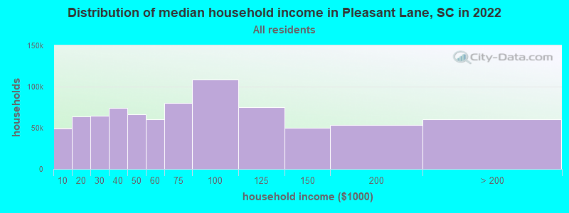
| Pleasant Lane: | $48,348 |
| SC: | $64,115 |
Estimated per capita income in 2022: $39,434 (it was $19,143 in 2000)
Pleasant Lane CCD income, earnings, and wages data
Estimated median house or condo value in 2022: $148,474 (it was $56,500 in 2000)
| Pleasant Lane: | $148,474 |
| SC: | $254,600 |
Mean prices in 2022: all housing units: $243,337; detached houses: $281,381; townhouses or other attached units: $147,242; mobile homes: $84,462; occupied boats, rvs, vans, etc.: $15,907
Detailed information about poverty and poor residents in Pleasant Lane, SC
Compare current foreclosures near Pleasant Lane, SC:
| Photo | Address | Area | Beds / Baths | Price | Details |
|---|---|---|---|---|---|

|
#1
Gaillard Dr
Ninety Six, SC 29666
|
1,008 sq. feet
|
2 baths 3 beds |
show details | |

|
#2
Dorn Rd W
Troy, SC 29848
|
1,613 sq. feet
|
2 baths 3 beds |
show details | |

|
#3
Bluebird Ln
Edgefield, SC 29824
|
1,275 sq. feet
|
- baths 1 beds |
show details | |

|
#4
Kathy Hill Rd
Greenwood, SC 29646
|
2,830 sq. feet
|
2 baths 4 beds |
show details | |

|
#5
Hardy Place Rd
Johnston, SC 29832
|
1,782 sq. feet
|
- baths 1 beds |
show details | |

|
#6
Highland Forest Dr
Greenwood, SC 29646
|
1,160 sq. feet
|
2 baths 3 beds |
show details | |

|
#7
Roland Ave
Johnston, SC 29832
|
1,725 sq. feet
|
- baths 1 beds |
show details | |

|
#8
Thurmond St
Edgefield, SC 29824
|
1,214 sq. feet
|
- baths 1 beds |
show details | |

|
#9
Coral St
Edgefield, SC 29824
|
2,370 sq. feet
|
- baths 1 beds |
show details | |

|
#10
Dean Rd
Saluda, SC 29138
|
1,080 sq. feet
|
1 baths - beds |
show details |
| Photo | Address | Area | Beds / Baths | Price | Details |
|---|---|---|---|---|---|

|
#11
Louden Rd
Ninety Six, SC 29666
|
1,297 sq. feet
|
2 baths 4 beds |
show details | |

|
#12
Johnston Hwy
Saluda, SC 29138
|
1,132 sq. feet
|
1 baths - beds |
show details | |

|
#13
Travis Ave
Saluda, SC 29138
|
2,155 sq. feet
|
- baths - beds |
show details | |

|
#14
Cedar Hill Rd
Mc Cormick, SC 29835
|
1,224 sq. feet
|
- baths 3 beds |
show details | |

|
#15
Logan St
Saluda, SC 29138
|
1,036 sq. feet
|
1 baths - beds |
show details | |

|
#16
Logan St
Saluda, SC 29138
|
975 sq. feet
|
1 baths - beds |
show details | |

|
#17
Dogwood Ln
Plum Branch, SC 29845
|
- sq. feet
|
- baths - beds |
show details | |

|
#18
S Oak St
Mc Cormick, SC 29835
|
- sq. feet
|
- baths - beds |
show details | |

|
#19
Mine Creek Rd
Saluda, SC 29138
|
2,128 sq. feet
|
- baths - beds |
show details | |

|
#20
John J Rushton Rd
Saluda, SC 29138
|
- sq. feet
|
- baths - beds |
show details |
| Photo | Address | Area | Beds / Baths | Price | Details |
|---|---|---|---|---|---|

|
#21
Amusement Dr
Ninety Six, SC 29666
|
- sq. feet
|
- baths - beds |
show details | |

|
#22
Lowell St
Ninety Six, SC 29666
|
1,667 sq. feet
|
- baths - beds |
show details | |

|
#23
Seminole Dr
Saluda, SC 29138
|
- sq. feet
|
- baths - beds |
show details | |

|
#24
Gordon Town Rd
Edgefield, SC 29824
|
- sq. feet
|
- baths - beds |
show details | |

|
#25
Drydock Cir
Saluda, SC 29138
|
- sq. feet
|
- baths - beds |
show details | |

|
#26
Plum Branch Rd
Edgefield, SC 29824
|
- sq. feet
|
- baths - beds |
show details | |

|
#27
New Hope Rd
Mc Cormick, SC 29835
|
- sq. feet
|
- baths - beds |
show details | |

|
#28
Holloway Rd
Saluda, SC 29138
|
- sq. feet
|
- baths - beds |
show details | |

|
#29
Gwen Rd
Saluda, SC 29138
|
- sq. feet
|
- baths - beds |
show details | |

|
#30
Pencreek Rd
Saluda, SC 29138
|
- sq. feet
|
- baths - beds |
show details |
| Photo | Address | Area | Beds / Baths | Price | Details |
|---|---|---|---|---|---|

|
#31
Bonham Rd
Saluda, SC 29138
|
- sq. feet
|
- baths - beds |
show details | |

|
#32
Mims St
Edgefield, SC 29824
|
- sq. feet
|
- baths - beds |
show details | |

|
#33
Promised Land Rd
Edgefield, SC 29824
|
- sq. feet
|
- baths - beds |
show details | |

|
#34
Old Gassaway Rd
Saluda, SC 29138
|
1,620 sq. feet
|
- baths - beds |
show details | |

|
#35
Timmerman St
Edgefield, SC 29824
|
- sq. feet
|
- baths - beds |
show details | |

|
#36
Us Highway 25 N
Edgefield, SC 29824
|
- sq. feet
|
- baths - beds |
show details | |

|
#37
Bruce Rd
Ninety Six, SC 29666
|
- sq. feet
|
- baths - beds |
show details | |

|
#38
Highway 25 S
Greenwood, SC 29646
|
- sq. feet
|
- baths - beds |
show details | |

|
#39
Summerfield Ct
Trenton, SC 29847
|
- sq. feet
|
- baths - beds |
show details | |

|
#40
Young St
Johnston, SC 29832
|
- sq. feet
|
- baths - beds |
show details |
| Photo | Address | Area | Beds / Baths | Price | Details |
|---|---|---|---|---|---|

|
Check over 1 million property listings on Foreclosure.com!
|
browse all offers | |||
| Photo | Address | Area | Beds / Baths | Price | Details |
|---|

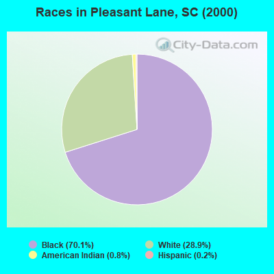
- 71370.1%Black alone
- 29428.9%White alone
- 80.8%American Indian alone
- 20.2%Hispanic
Races in Pleasant Lane detailed stats: ancestries, foreign born residents, place of birth
 Recent articles from our blog. Our writers, many of them Ph.D. graduates or candidates, create easy-to-read articles on a wide variety of topics.
Current Local Time: EST time zone
Elevation: 420 feet
Land area: 81.7 square miles.
Population density: 13 people per square mile (very low).

| Pleasant Lane CCD: | 0.5% ($273) |
| South Carolina: | 0.6% ($510) |
Nearest city with pop. 50,000+: Augusta, GA  (32.4 miles , pop. 138,000).
Nearest city with pop. 200,000+: Charlotte, NC (111.3 miles , pop. 540,828).
Nearest city with pop. 1,000,000+: Philadelphia, PA (565.7 miles , pop. 1,517,550).
Nearest cities:
), ), Latitude: 33.93 N, Longitude: 82.02 W

| Here: | 3.2% |
| South Carolina: | 3.1% |
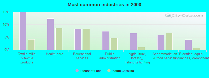
- Textile mills & textile products (15.0%)
- Health care (12.4%)
- Educational services (8.4%)
- Public administration (7.4%)
- Agriculture, forestry, fishing & hunting (6.6%)
- Accommodation & food services (5.8%)
- Electrical equipment, appliances, components (4.1%)
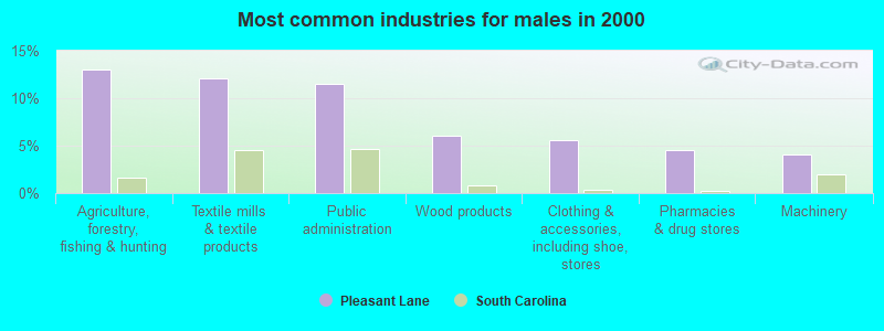
- Agriculture, forestry, fishing & hunting (13.1%)
- Textile mills & textile products (12.1%)
- Public administration (11.6%)
- Wood products (6.0%)
- Clothing & accessories, including shoe, stores (5.5%)
- Pharmacies & drug stores (4.5%)
- Machinery (4.0%)
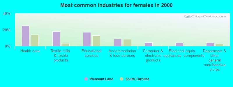
- Health care (25.1%)
- Textile mills & textile products (17.9%)
- Educational services (16.9%)
- Accommodation & food services (8.7%)
- Computer & electronic products (4.6%)
- Electrical equipment, appliances, components (4.1%)
- Department & other general merchandise stores (4.1%)
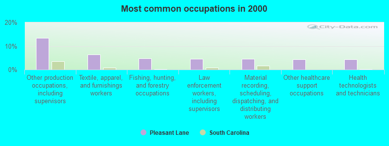
- Other production occupations, including supervisors (13.5%)
- Textile, apparel, and furnishings workers (6.3%)
- Fishing, hunting, and forestry occupations (4.8%)
- Law enforcement workers, including supervisors (4.6%)
- Material recording, scheduling, dispatching, and distributing workers (4.6%)
- Other healthcare support occupations (4.3%)
- Health technologists and technicians (4.3%)
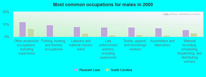
- Other production occupations, including supervisors (12.1%)
- Fishing, hunting, and forestry occupations (9.5%)
- Laborers and material movers, hand (8.0%)
- Law enforcement workers, including supervisors (7.5%)
- Textile, apparel, and furnishings workers (7.5%)
- Assemblers and fabricators (7.0%)
- Material recording, scheduling, dispatching, and distributing workers (5.5%)
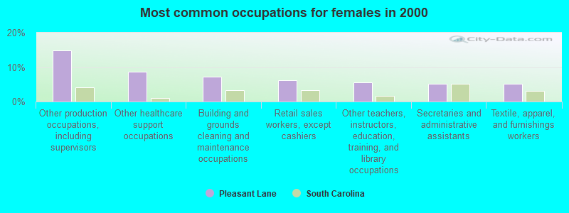
- Other production occupations, including supervisors (14.9%)
- Other healthcare support occupations (8.7%)
- Building and grounds cleaning and maintenance occupations (7.2%)
- Retail sales workers, except cashiers (6.2%)
- Other teachers, instructors, education, training, and library occupations (5.6%)
- Secretaries and administrative assistants (5.1%)
- Textile, apparel, and furnishings workers (5.1%)
Average climate in Pleasant Lane, South Carolina
Based on data reported by over 4,000 weather stations


(lower is better)
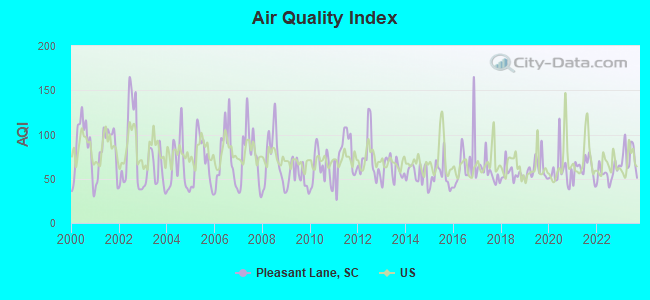
Air Quality Index (AQI) level in 2023 was 74.1. This is about average.
| City: | 74.1 |
| U.S.: | 72.6 |
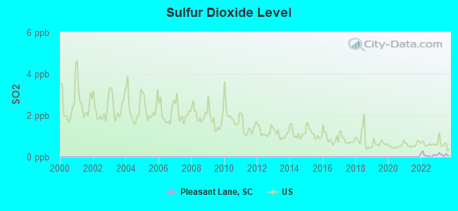
Sulfur Dioxide (SO2) [ppb] level in 2023 was 0.101. This is significantly better than average. Closest monitor was 16.1 miles away from the city center.
| City: | 0.101 |
| U.S.: | 1.515 |

Ozone [ppb] level in 2023 was 28.8. This is about average. Closest monitor was 16.1 miles away from the city center.
| City: | 28.8 |
| U.S.: | 33.3 |
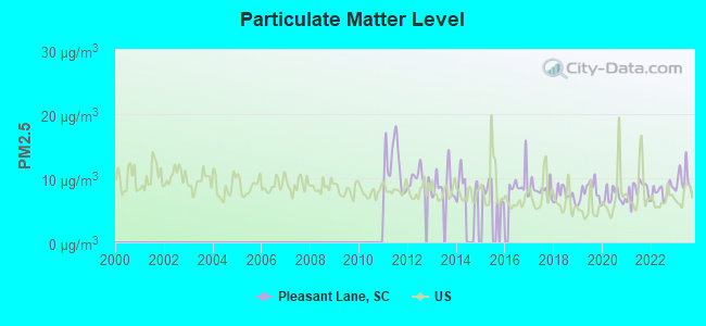
Particulate Matter (PM2.5) [µg/m3] level in 2023 was 9.72. This is about average. Closest monitor was 16.1 miles away from the city center.
| City: | 9.72 |
| U.S.: | 8.11 |
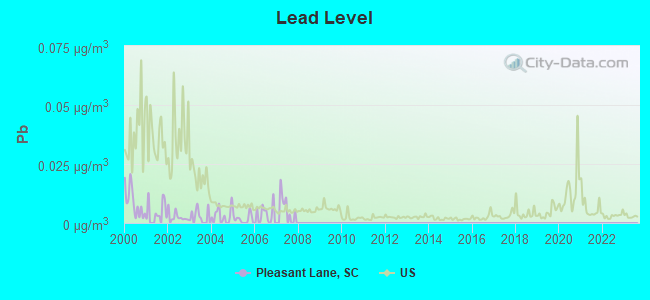
Lead (Pb) [µg/m3] level in 2007 was 0.00468. This is significantly better than average. Closest monitor was 16.1 miles away from the city center.
| City: | 0.00468 |
| U.S.: | 0.00931 |
Tornado activity:
Pleasant Lane-area historical tornado activity is near South Carolina state average. It is 18% greater than the overall U.S. average.
On 12/13/1973, a category F4 (max. wind speeds 207-260 mph) tornado 17.4 miles away from the Pleasant Lane place center killed 2 people and caused between $500,000 and $5,000,000 in damages.
On 3/31/1973, a category F4 tornado 27.1 miles away from the place center killed 7 people and injured 30 people and caused between $500,000 and $5,000,000 in damages.
Earthquake activity:
Pleasant Lane-area historical earthquake activity is significantly above South Carolina state average. It is 7% smaller than the overall U.S. average.On 8/2/1974 at 08:52:09, a magnitude 4.9 (4.3 MB, 4.9 LG, Class: Light, Intensity: IV - V) earthquake occurred 27.3 miles away from the city center
On 8/9/2020 at 12:07:37, a magnitude 5.1 (5.1 MW, Depth: 4.7 mi, Class: Moderate, Intensity: VI - VII) earthquake occurred 183.7 miles away from the city center
On 11/22/1974 at 05:25:55, a magnitude 4.7 (4.7 MB) earthquake occurred 129.4 miles away from the city center
On 2/15/2014 at 03:23:38, a magnitude 4.1 (4.1 MW, Depth: 3.2 mi) earthquake occurred 8.9 miles away from the city center
On 8/23/2011 at 17:51:04, a magnitude 5.8 (5.8 MW, Depth: 3.7 mi) earthquake occurred 357.8 miles away from the city center
On 11/30/1973 at 07:48:41, a magnitude 4.7 (4.7 MB, 4.6 ML) earthquake occurred 170.1 miles away from the city center
Magnitude types: regional Lg-wave magnitude (LG), body-wave magnitude (MB), local magnitude (ML), moment magnitude (MW)
Natural disasters:
The number of natural disasters in Edgefield County (11) is smaller than the US average (15).Major Disasters (Presidential) Declared: 4
Emergencies Declared: 5
Causes of natural disasters: Hurricanes: 3, Winter Storms: 3, Floods: 2, Storms: 2, Drought: 1, Ice Storm: 1, Other: 1 (Note: some incidents may be assigned to more than one category).
Hospitals and medical centers near Pleasant Lane:
- DCA EDGEFIELD (Dialysis Facility, about 11 miles away; EDGEFIELD, SC)
- EDGEFIELD COMMUNITY RESIDENCE (Hospital, about 12 miles away; EDGEFIELD, SC)
- DIALYSIS CLINIC INC-SALUDA (Dialysis Facility, about 15 miles away; SALUDA, SC)
- LUTHERAN HOSPICE OF UPPER SAVANNAH (Hospital, about 16 miles away; MC CORMICK, SC)
Colleges/universities with over 2000 students nearest to Pleasant Lane:
- Piedmont Technical College (about 21 miles; Greenwood, SC; Full-time enrollment: 4,831)
- Lander University (about 21 miles; Greenwood, SC; FT enrollment: 2,870)
- University of South Carolina-Aiken (about 29 miles; Aiken, SC; FT enrollment: 2,815)
- Aiken Technical College (about 30 miles; Graniteville, SC; FT enrollment: 2,107)
- Georgia Regents University (about 32 miles; Augusta, GA; FT enrollment: 6,862)
- Augusta Technical College (about 36 miles; Augusta, GA; FT enrollment: 3,494)
- Midlands Technical College (about 52 miles; West Columbia, SC; FT enrollment: 8,916)
Points of interest:
Notable locations in Pleasant Lane: Tompkins Community House (A), Cyper Creek Picnic Grounds (B), Limestone Farm (C), Northside Fire Department Main Station (D), Northside Fire Department Northside Substation (E), Limestone Community Center (F). Display/hide their locations on the map
Churches in Pleasant Lane include: Pine Grove Church (A), Highway Holy Church (B), McKendree Church (C), Springfield Church (D), Willow Springs Church (E), Little Stevens Creek Church (F), Liberty Spring Church (G), Gilgal Church (H), Pleasant Lane Church (I). Display/hide their locations on the map
Cemeteries: Cochran Cemetery (1), Dorn Cemetery (2), Hamilton Cemetery (3), Harling Cemetery (4), Hegwood Cemetery (5), Liberty Spring Cemetery (6). Display/hide their locations on the map
Reservoir: Corley Pond (A). Display/hide its location on the map
Streams, rivers, and creeks: Wilson Branch (A), Stockman Branch (B), Sleepy Creek (C), Quaker Branch (D), Little Stevens Creek (E), Little Mountain Creek (F), Jim Branch (G), Hegwood Branch (H), Cartledge Branch (I). Display/hide their locations on the map
| This place: | 2.5 people |
| South Carolina: | 2.5 people |
| This place: | 69.4% |
| Whole state: | 67.5% |
| This place: | 3.7% |
| Whole state: | 6.0% |
Likely homosexual households (counted as self-reported same-sex unmarried-partner households)
- Lesbian couples: 0.3% of all households
- Gay men: 0.3% of all households
| This place: | 18.9% |
| Whole state: | 14.1% |
| This place: | 11.7% |
| Whole state: | 6.5% |
For population 15 years and over in Pleasant Lane:
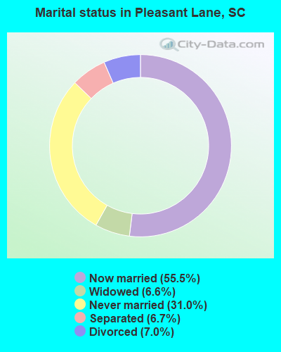
- Never married: 31.0%
- Now married: 55.5%
- Separated: 6.7%
- Widowed: 6.6%
- Divorced: 7.0%
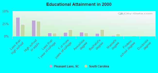
For population 25 years and over in Pleasant Lane:
- High school or higher: 62.4%
- Bachelor's degree or higher: 7.5%
- Graduate or professional degree: 1.6%
- Unemployed: 7.9%
- Mean travel time to work (commute): 34.6 minutes
| Here: | 16.0 |
| South Carolina average: | 13.2 |
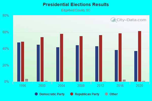
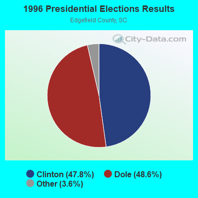
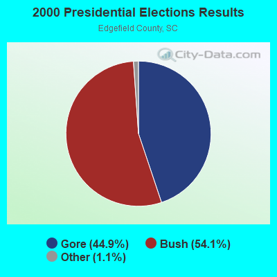
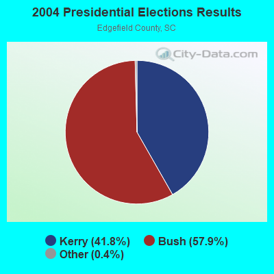
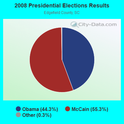
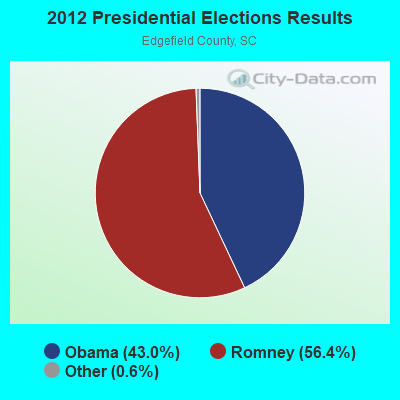
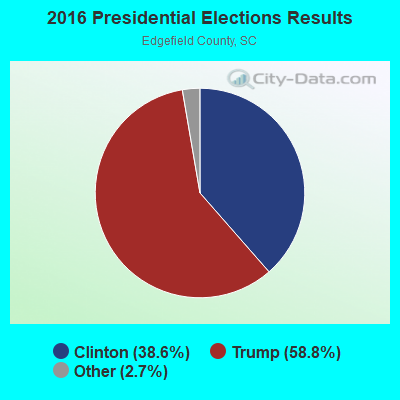
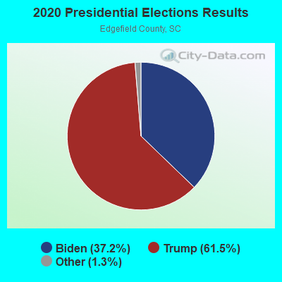
Graphs represent county-level data. Detailed 2008 Election Results
Religion statistics for Pleasant Lane, SC (based on Edgefield County data)
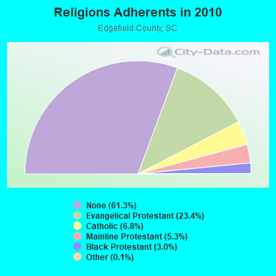
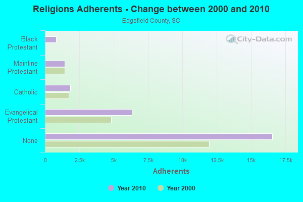
| Religion | Adherents | Congregations |
|---|---|---|
| Evangelical Protestant | 6,325 | 29 |
| Catholic | 1,830 | 2 |
| Mainline Protestant | 1,439 | 9 |
| Black Protestant | 804 | 5 |
| Other | 36 | 1 |
| None | 16,551 | - |
Food Environment Statistics:
| This county: | 1.18 / 10,000 pop. |
| State: | 1.99 / 10,000 pop. |
| This county: | 0.79 / 10,000 pop. |
| State: | 0.85 / 10,000 pop. |
| Edgefield County: | 4.73 / 10,000 pop. |
| South Carolina: | 5.38 / 10,000 pop. |
| This county: | 5.13 / 10,000 pop. |
| State: | 7.75 / 10,000 pop. |
| Edgefield County: | 10.0% |
| South Carolina: | 10.6% |
| This county: | 33.0% |
| South Carolina: | 29.4% |
| Edgefield County: | 9.0% |
| State: | 13.4% |
Strongest AM radio stations in Pleasant Lane:
- WBAJ (890 AM; daytime; 50 kW; BLYTHEWOOD, SC; Owner: FAMILY FIRST)
- WLFJ (660 AM; daytime; 50 kW; GREENVILLE, SC; Owner: CLEAR CHANNEL BROADCASTING LICENSES, INC.)
- WCZZ (1090 AM; daytime; 5 kW; GREENWOOD, SC; Owner: KEENE OF SOUTH CAROLINA, INC.)
- WCEO (840 AM; daytime; 50 kW; COLUMBIA, SC; Owner: EASTERN BROADCASTING GROUP, INC.)
- WBCU (1460 AM; 50 kW; UNION, SC)
- WGAC (580 AM; 5 kW; AUGUSTA, GA; Owner: WGAC LICENSE, LLC)
- WCSZ (1070 AM; 50 kW; SANS SOUCI, SC; Owner: WHYZ RADIO, L.P.)
- WRDW (1480 AM; 10 kW; AUGUSTA, GA; Owner: WCHZ LICENSE, LLC)
- WTEL (1630 AM; 10 kW; AUGUSTA, GA; Owner: WCHZ LICENSE, LLC)
- WJES (1190 AM; 1 kW; SALUDA, SC; Owner: EDGEFIELD-SALUDA RADIO COMPANY, INC.)
- WLGO (1170 AM; daytime; 10 kW; LEXINGTON, SC; Owner: LEVAS COMMUNICATIONS, LLC)
- WBLR (1430 AM; 5 kW; BATESBURG, SC; Owner: BARINOWSKI INVESTMENT COMPANY)
- WFAM (1050 AM; 5 kW; AUGUSTA, GA; Owner: J.J. & B. BROADCASTING, INC.)
Strongest FM radio stations in Pleasant Lane:
- WBBQ-FM (104.3 FM; AUGUSTA, GA; Owner: CAPSTAR TX LIMITED PARTNERSHIP)
- WKSX-FM (92.7 FM; JOHNSTON, SC; Owner: EDGEFIELD-SALUDA RADIO COMPANY, INC.)
- WKXC-FM (99.5 FM; AIKEN, SC; Owner: WGAC LICENSE, LLC)
- WAFJ (88.3 FM; BELVEDERE, SC; Owner: RADIO TRAINING NETWORK, INC.)
- WZNY (105.7 FM; AUGUSTA, GA; Owner: CAPSTAR TX LIMITED PARTNERSHIP)
- WKSP (96.3 FM; AIKEN, SC; Owner: CAPSTAR TX LIMITED PARTNERSHIP)
- WSSL-FM (100.5 FM; GRAY COURT, SC; Owner: CAPSTAR TX LIMITED PARTNERSHIP)
- WJES-FM (92.1 FM; SALUDA, SC; Owner: BRECKENRIDGE COMMUNICATIONS, LLC)
- WLPE (91.7 FM; AUGUSTA, GA; Owner: AUGUSTA RADIO FELLOWSHIP INSTITUTE, INC.)
- WROQ (101.1 FM; ANDERSON, SC; Owner: OBC BROADCASTING, INC.)
- WHZQ (94.1 FM; CROSS HILL, SC; Owner: SOUTHEASTERN BROADCAST ASSOCIATES, INC.)
- WAKB (96.9 FM; WRENS, GA; Owner: RADIO ONE OF AUGUSTA, LLC)
- WPRW-FM (107.7 FM; MARTINEZ, GA; Owner: CAPSTAR TX LIMITED PARTNERSHIP)
- WEKL (102.3 FM; AUGUSTA, GA; Owner: CAPSTAR TX LIMITED PARTNERSHIP)
- W274AE (102.7 FM; GREENWOOD, SC; Owner: BIBLE BROADCASTING NETWORK, INC.)
- WZSN (103.5 FM; GREENWOOD, SC; Owner: KEENE OF SOUTH CAROLINA, INC.)
TV broadcast stations around Pleasant Lane:
- WJBF (Channel 6; AUGUSTA, GA; Owner: MEDIA GENERAL BROADCASTING OF SO. CAROLINA HOLDINGS, INC.)
- WAGT (Channel 26; AUGUSTA, GA; Owner: WAGT TELEVISION, INC.)
- WRDW-TV (Channel 12; AUGUSTA, GA; Owner: WRDW LICENSEE CORP.)
- W56EE (Channel 56; JOHNSTON, SC; Owner: DOVE BROADCASTING, INC.)
- WFXG (Channel 54; AUGUSTA, GA; Owner: FISHER BROADCASTING - GEORGIA, L.L.C.)
- WCES-TV (Channel 20; WRENS, GA; Owner: GEORGIA PUBLIC TELECOMMUNICATIONS COMMISSION)
- WBPI-LP (Channel 49; AUGUSTA, GA; Owner: WATCHMAN BROADCASTING PRODUCTIONS INTERNATIONAL, INC.)
- WNEH (Channel 38; GREENWOOD, SC; Owner: SOUTH CAROLINA EDUCATIONAL TV COMMISSION)
- W58CZ (Channel 58; AUGUSTA, GA; Owner: TRINITY BROADCASTING NETWORK)
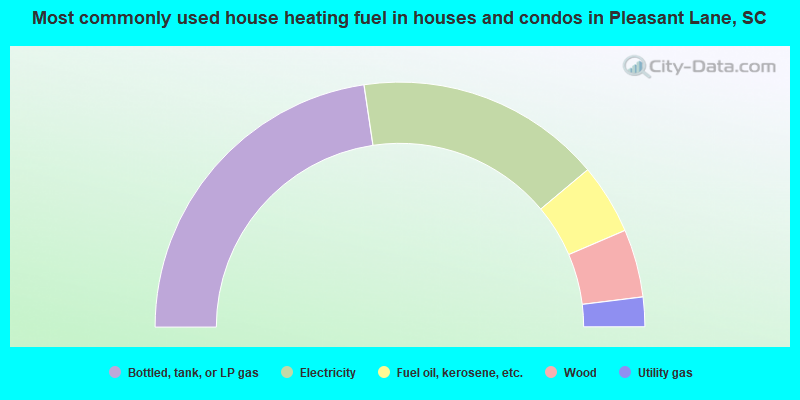
- 45.3%Bottled, tank, or LP gas
- 32.5%Electricity
- 9.3%Fuel oil, kerosene, etc.
- 9.0%Wood
- 3.9%Utility gas
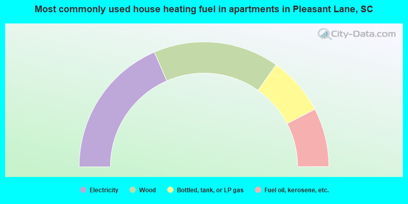
- 37.0%Electricity
- 32.6%Wood
- 15.2%Bottled, tank, or LP gas
- 15.2%Fuel oil, kerosene, etc.
Pleasant Lane compared to South Carolina state average:
- Median house value below state average.
- Unemployed percentage below state average.
- Black race population percentage above state average.
- Hispanic race population percentage significantly below state average.
- Foreign-born population percentage significantly below state average.
- Renting percentage significantly below state average.
- Length of stay since moving in significantly above state average.
- Number of rooms per house significantly below state average.
- House age significantly below state average.
- Percentage of population with a bachelor's degree or higher significantly below state average.