Plateau of the Barrens, Tennessee
Submit your own pictures of this place and show them to the world
- OSM Map
- General Map
- Google Map
- MSN Map

| Males: 1,573 | |
| Females: 1,637 |
| Median resident age: | 35.2 years |
| Tennessee median age: | 35.9 years |
Zip code: 37026
| Plateau of the Barrens: | $60,530 |
| TN: | $65,254 |
Estimated per capita income in 2022: $28,672 (it was $15,276 in 2000)
Plateau of the Barrens CCD income, earnings, and wages data
Estimated median house or condo value in 2022: $293,346 (it was $88,400 in 2000)
| Plateau of the Barrens: | $293,346 |
| TN: | $284,800 |
Mean prices in 2022: all housing units: $295,965; detached houses: $308,916; townhouses or other attached units: over $1,000,000; mobile homes: $90,695
Plateau of the Barrens, TN residents, houses, and apartments details
Detailed information about poverty and poor residents in Plateau of the Barrens, TN
Compare current foreclosures near Plateau of the Barrens, TN:


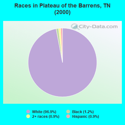
- 2,98996.9%White alone
- 361.2%Black alone
- 290.9%Two or more races
- 270.9%Hispanic
- 30.10%American Indian alone
- 10.03%Asian alone
Races in Plateau of the Barrens detailed stats: ancestries, foreign born residents, place of birth
 Recent articles from our blog. Our writers, many of them Ph.D. graduates or candidates, create easy-to-read articles on a wide variety of topics.
Current Local Time: CST time zone
Land area: 55.4 square miles.
Population density: 58 people per square mile (very low).

| Plateau of the Barrens CCD: | 0.5% ($473) |
| Tennessee: | 0.8% ($715) |
Nearest city with pop. 50,000+: Murfreesboro, TN  (23.2 miles , pop. 68,816).
Nearest city with pop. 200,000+: Nashville-Davidson, TN (51.6 miles , pop. 545,524).
Nearest city with pop. 1,000,000+: Chicago, IL (433.6 miles , pop. 2,896,016).
Nearest cities:
), ), ), ), ), )Latitude: 35.71 N, Longitude: 86.03 W
Area code commonly used in this area: 931

| Here: | 2.7% |
| Tennessee: | 3.0% |

- Health care (9.4%)
- Agriculture, forestry, fishing & hunting (8.5%)
- Construction (8.2%)
- Educational services (7.6%)
- Public administration (4.7%)
- Accommodation & food services (4.7%)
- Machinery (4.6%)

- Construction (12.3%)
- Agriculture, forestry, fishing & hunting (11.1%)
- Health care (7.0%)
- Public administration (6.0%)
- Machinery (5.3%)
- Transportation equipment (5.3%)
- Department & other general merchandise stores (4.3%)

- Educational services (16.1%)
- Health care (12.0%)
- Accommodation & food services (7.9%)
- Agriculture, forestry, fishing & hunting (5.6%)
- Miscellaneous manufacturing (5.0%)
- Food & beverage stores (4.6%)
- Department & other general merchandise stores (4.0%)

- Other production occupations, including supervisors (9.0%)
- Material recording, scheduling, dispatching, and distributing workers (4.9%)
- Other management occupations, except farmers and farm managers (4.1%)
- Farmers and farm managers (4.0%)
- Nursing, psychiatric, and home health aides (4.0%)
- Secretaries and administrative assistants (3.8%)
- Textile, apparel, and furnishings workers (3.6%)

- Other production occupations, including supervisors (10.8%)
- Farmers and farm managers (6.0%)
- Material recording, scheduling, dispatching, and distributing workers (6.0%)
- Other management occupations, except farmers and farm managers (5.8%)
- Metal workers and plastic workers (5.5%)
- Vehicle and mobile equipment mechanics, installers, and repairers (5.0%)
- Driver/sales workers and truck drivers (4.9%)

- Secretaries and administrative assistants (8.1%)
- Other production occupations, including supervisors (6.9%)
- Cashiers (5.7%)
- Textile, apparel, and furnishings workers (5.4%)
- Bookkeeping, accounting, and auditing clerks (5.3%)
- Nursing, psychiatric, and home health aides (5.3%)
- Preschool, kindergarten, elementary, and middle school teachers (5.1%)
Average climate in Plateau of the Barrens, Tennessee
Based on data reported by over 4,000 weather stations


(lower is better)

Air Quality Index (AQI) level in 2004 was 72.6. This is about average.
| City: | 72.6 |
| U.S.: | 72.6 |

Nitrogen Dioxide (NO2) [ppb] level in 2004 was 2.46. This is significantly better than average. Closest monitor was 8.5 miles away from the city center.
| City: | 2.46 |
| U.S.: | 5.11 |

Sulfur Dioxide (SO2) [ppb] level in 2004 was 1.58. This is about average. Closest monitor was 8.5 miles away from the city center.
| City: | 1.58 |
| U.S.: | 1.51 |

Ozone [ppb] level in 2004 was 33.5. This is about average. Closest monitor was 8.5 miles away from the city center.
| City: | 33.5 |
| U.S.: | 33.3 |
Tornado activity:
Plateau of the Barrens-area historical tornado activity is slightly above Tennessee state average. It is 70% greater than the overall U.S. average.
On 4/3/1974, a category F5 (max. wind speeds 261-318 mph) tornado 14.3 miles away from the Plateau of the Barrens place center killed 16 people and injured 190 people.
On 1/24/1997, a category F4 (max. wind speeds 207-260 mph) tornado 21.6 miles away from the place center injured 18 people and caused $5 million in damages.
Earthquake activity:
Plateau of the Barrens-area historical earthquake activity is significantly above Tennessee state average. It is 156% greater than the overall U.S. average.On 4/29/2003 at 08:59:39, a magnitude 4.9 (4.4 MB, 4.6 MW, 4.9 LG, Class: Light, Intensity: IV - V) earthquake occurred 86.8 miles away from the city center
On 4/18/2008 at 09:36:59, a magnitude 5.4 (5.1 MB, 4.8 MS, 5.4 MW, 5.2 MW, Class: Moderate, Intensity: VI - VII) earthquake occurred 215.9 miles away from Plateau of the Barrens center
On 7/27/1980 at 18:52:21, a magnitude 5.2 (5.1 MB, 4.7 MS, 5.0 UK, 5.2 UK) earthquake occurred 207.7 miles away from the city center
On 4/29/2003 at 08:59:39, a magnitude 4.6 (4.6 MW, Depth: 12.3 mi) earthquake occurred 86.8 miles away from Plateau of the Barrens center
On 4/18/2008 at 09:36:59, a magnitude 5.2 (5.2 MW, Depth: 8.9 mi) earthquake occurred 215.9 miles away from Plateau of the Barrens center
On 11/30/1973 at 07:48:41, a magnitude 4.7 (4.7 MB, 4.6 ML) earthquake occurred 116.1 miles away from the city center
Magnitude types: regional Lg-wave magnitude (LG), body-wave magnitude (MB), local magnitude (ML), surface-wave magnitude (MS), moment magnitude (MW)
Natural disasters:
The number of natural disasters in Cannon County (14) is near the US average (15).Major Disasters (Presidential) Declared: 11
Emergencies Declared: 2
Causes of natural disasters: Floods: 7, Storms: 7, Tornadoes: 4, Winter Storms: 3, Flash Flood: 1, Heavy Rain: 1, Hurricane: 1, Ice Storm: 1, Snowfall: 1, Wind: 1, Other: 1 (Note: some incidents may be assigned to more than one category).
Hospitals and medical centers near Plateau of the Barrens:
- WOODBURY HEALTH CENTER (Nursing Home, about 9 miles away; WOODBURY, TN)
- STONES RIVER HOSPITAL & DEKALB COMMUNITY HOSPITAL Acute Care Hospitals (about 10 miles away; WOODBURY, TN)
- NHC HEALTHCARE, MCMINNVILLE (Nursing Home, about 14 miles away; MC MINNVILLE, TN)
- CAREALL HOME CARE SERVICES (Home Health Center, about 15 miles away; MC MINNVILLE, TN)
- FRIENDSHIP HOME HEALTH, INC (Home Health Center, about 15 miles away; MC MINNVILLE, TN)
- MEDICAL CENTER OF MANCHESTER Critical Access Hospitals (about 15 miles away; MANCHESTER, TN)
- MANCHESTER HEALTH CARE CENTER (Nursing Home, about 15 miles away; MANCHESTER, TN)
Colleges/universities with over 2000 students nearest to Plateau of the Barrens:
- Middle Tennessee State University (about 22 miles; Murfreesboro, TN; Full-time enrollment: 21,628)
- Motlow State Community College (about 29 miles; Tullahoma, TN; FT enrollment: 2,915)
- Tennessee Technological University (about 44 miles; Cookeville, TN; FT enrollment: 9,761)
- Trevecca Nazarene University (about 51 miles; Nashville, TN; FT enrollment: 2,223)
- Lipscomb University (about 52 miles; Nashville, TN; FT enrollment: 3,827)
- Belmont University (about 53 miles; Nashville, TN; FT enrollment: 5,795)
- Volunteer State Community College (about 53 miles; Gallatin, TN; FT enrollment: 5,311)
Points of interest:
Notable locations in Plateau of the Barrens: Mid - Way Volunteer Fire Department (A), Mooretown Volunteer Fire Department (B). Display/hide their locations on the map
Churches in Plateau of the Barrens include: Pleasant View Baptist Church (A), Plainview Baptist Church (B), Ivy Bluff Methodist Church (C), Smith Grove Church (D), Bluewing Baptist Church (E), Red Hill Church (F), Iconium Church of Christ (G), Amity Church (H), Midway Church (I). Display/hide their locations on the map
Cemeteries: Tolbert Cemetery (1), Tucker Cemetery (2), Liberty Cemetery (3), Lorance Cemetery (4), Campbell Cemetery (5), Smithson Cemetery (6). Display/hide their locations on the map
Reservoirs: Lake Ann (A), Lake Anne (B). Display/hide their locations on the map
Streams, rivers, and creeks: Log Branch (A), Lewis Creek (B), Josh Creek (C), Hayes Creek (D), Duke Creek (E), Crane Branch (F), Cooper Branch (G), Poplar Branch (H), Swanger Branch (I). Display/hide their locations on the map
| This place: | 2.7 people |
| Tennessee: | 2.5 people |
| This place: | 70.1% |
| Whole state: | 69.8% |
| This place: | 4.2% |
| Whole state: | 4.2% |
Likely homosexual households (counted as self-reported same-sex unmarried-partner households)
- Lesbian couples: 0.2% of all households
- Gay men: 0.1% of all households
| This place: | 11.3% |
| Whole state: | 13.5% |
| This place: | 3.8% |
| Whole state: | 5.8% |
For population 15 years and over in Plateau of the Barrens:

- Never married: 16.6%
- Now married: 70.0%
- Separated: 0.2%
- Widowed: 5.4%
- Divorced: 8.0%
For population 25 years and over in Plateau of the Barrens:
- High school or higher: 68.8%
- Bachelor's degree or higher: 6.7%
- Graduate or professional degree: 1.0%
- Unemployed: 4.3%
- Mean travel time to work (commute): 30.8 minutes


| Here: | 11.1 |
| Tennessee average: | 13.3 |
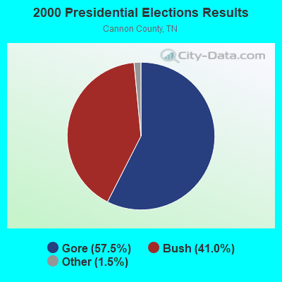
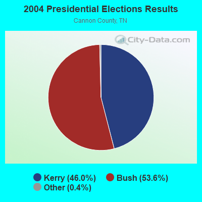
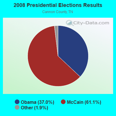
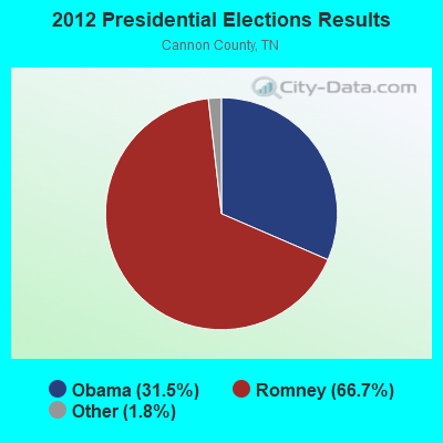
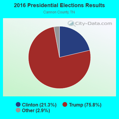
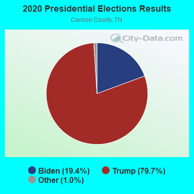
Graphs represent county-level data. Detailed 2008 Election Results
Religion statistics for Plateau of the Barrens, TN (based on Cannon County data)
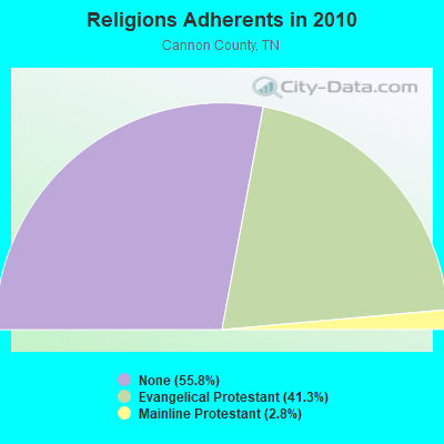
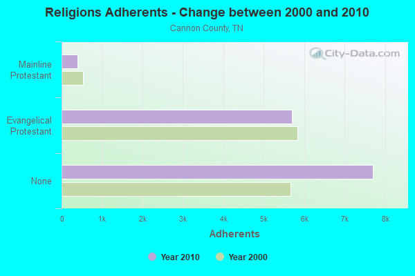
| Religion | Adherents | Congregations |
|---|---|---|
| Evangelical Protestant | 5,705 | 42 |
| Mainline Protestant | 389 | 5 |
| Catholic | - | - |
| Other | - | 1 |
| None | 7,707 | - |
Food Environment Statistics:
| This county: | 2.23 / 10,000 pop. |
| Tennessee: | 1.99 / 10,000 pop. |
| This county: | 0.74 / 10,000 pop. |
| State: | 0.65 / 10,000 pop. |
| This county: | 5.21 / 10,000 pop. |
| Tennessee: | 5.16 / 10,000 pop. |
| This county: | 3.72 / 10,000 pop. |
| Tennessee: | 6.56 / 10,000 pop. |
| This county: | 10.9% |
| Tennessee: | 11.4% |
| Cannon County: | 28.1% |
| Tennessee: | 30.2% |
| Cannon County: | 13.0% |
| State: | 13.5% |
Strongest AM radio stations in Plateau of the Barrens:
- WSM (650 AM; 50 kW; NASHVILLE, TN; Owner: GAYLORD ENTERTAINMENT COMPANY)
- WWAM (820 AM; daytime; 50 kW; JASPER, TN; Owner: SHELTON BROADCASTING SYSTEM)
- WAMB (1160 AM; 50 kW; DONELSON, TN; Owner: GREAT SOUTHERN BROADCASTING COMPANY, INC.)
- WMSR (1320 AM; 5 kW; MANCHESTER, TN; Owner: COFFEE COUNTY BROADCASTING, INC.)
- WFLI (1070 AM; 50 kW; LOOKOUT MOUNTAIN, TN; Owner: WFLI, INC.)
- WKDA (1200 AM; 50 kW; NASHVILLE, TN; Owner: RADIO NASHVILLE, INC.)
- WNQM (1300 AM; 50 kW; NASHVILLE, TN; Owner: WNQM. INC.)
- WMGC (810 AM; 5 kW; MURFREESBORO, TN; Owner: RADIO 810 NASHVILLE, LIMITED)
- WLAC (1510 AM; 50 kW; NASHVILLE, TN; Owner: CAPSTAR TX LIMITED PARTNERSHIP)
- WLOR (1550 AM; 50 kW; HUNTSVILLE, AL; Owner: BCA RADIO, LLC)
- WKVL (850 AM; daytime; 50 kW; KNOXVILLE, TN; Owner: HORNE RADIO, LLC)
- WAKI (1230 AM; 1 kW; MCMINNVILLE, TN; Owner: CITICASTERS LICENSES, L.P.)
- WLIJ (1580 AM; 5 kW; SHELBYVILLE, TN)
Strongest FM radio stations in Plateau of the Barrens:
- WWTN (99.7 FM; MANCHESTER, TN; Owner: CUMULUS LICENSING CORP.)
- WBOZ (104.9 FM; WOODBURY, TN; Owner: REACH SATELLITE NETWORK)
- WMOT (89.5 FM; MURFREESBORO, TN; Owner: MIDDLE TENNESSEE STATE UNIVERSITY)
- WBUZ (102.9 FM; LA VERGNE, TN; Owner: WYCQ, INC)
- WTRZ-FM (103.9 FM; MCMINNVILLE, TN; Owner: CITICASTERS LICENSES, L.P.)
- WRLT (100.1 FM; FRANKLIN, TN; Owner: TUNED-IN BROADCASTING, INC)
- WUSY (100.7 FM; CLEVELAND, TN; Owner: CAPSTAR TX LIMITED PARTNERSHIP)
- WFCM-FM (91.7 FM; MURFREESBORO, TN; Owner: THE MOODY BIBLE INSTITUTE OF CHICAGO)
- WGSQ (94.7 FM; COOKEVILLE, TN; Owner: CLEAR CHANNEL BROADCASTING LICENSES, INC.)
- WKZP (107.3 FM; SPENCER, TN; Owner: CITICASTERS LICENSES, L.P.)
- WSGM (104.7 FM; COALMONT, TN; Owner: CUMBERLAND COMMUNICATION CORPORATION)
- WZYZ (90.1 FM; SPENCER, TN; Owner: CHURCH FAITH TRINITY ASSEMBLIES)
- W211AS (90.1 FM; SPENCER, TN; Owner: AMERICAN FAMILY ASSOCIATION)
- WFTZ (101.5 FM; MANCHESTER, TN; Owner: PHASE TWO COMMUNICATIONS, INC.)
- WTML (91.5 FM; TULLAHOMA, TN; Owner: NASHVILLE PUBLIC RADIO)
- WJLE-FM (101.7 FM; SMITHVILLE, TN; Owner: LEON B. STRIBLING AND W.E. VANETTA)
TV broadcast stations around Plateau of the Barrens:
- WFLI-TV (Channel 53; CLEVELAND, TN; Owner: CHATTANOOGA MEDIA HOLDINGS, L.L.C.)
- WNAB (Channel 58; NASHVILLE, TN; Owner: NASHVILLE LICENSE HOLDINGS, L.L.C.)
- WHTN (Channel 39; MURFREESBORO, TN; Owner: CHRISTIAN TELEVISION NETWORK, INC.)
- WETV-LP (Channel 11; MURFREESBORO, TN; Owner: CHANNEL ELEVEN, INC.)
- WHRT-LP (Channel 27; MURFREESBORO, TN; Owner: LANDMARK ARTS, INC.)
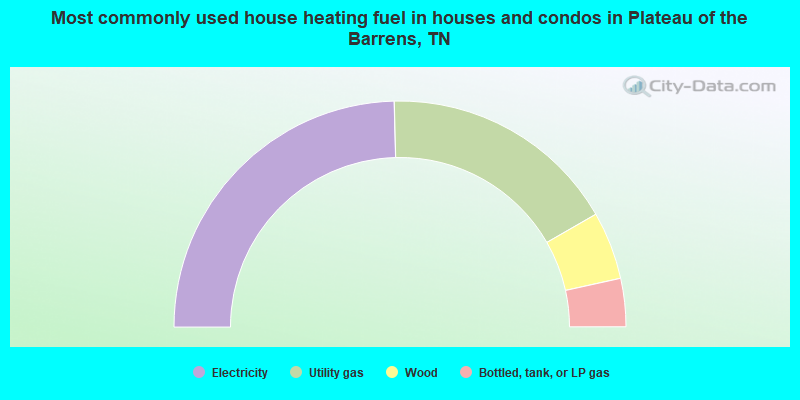
- 49.2%Electricity
- 34.2%Utility gas
- 9.7%Wood
- 6.9%Bottled, tank, or LP gas
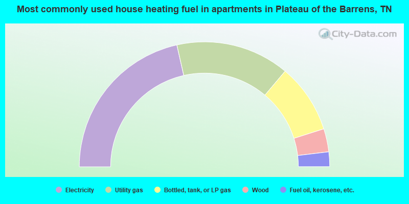
- 42.9%Electricity
- 29.3%Utility gas
- 17.9%Bottled, tank, or LP gas
- 6.0%Wood
- 3.8%Fuel oil, kerosene, etc.
Plateau of the Barrens compared to Tennessee state average:
- Unemployed percentage significantly below state average.
- Black race population percentage significantly below state average.
- Hispanic race population percentage significantly below state average.
- Median age below state average.
- Foreign-born population percentage significantly below state average.
- Renting percentage significantly below state average.
- Length of stay since moving in significantly above state average.
- Number of rooms per house significantly below state average.
- House age significantly below state average.
- Percentage of population with a bachelor's degree or higher significantly below state average.