Mozelle, Kentucky
Submit your own pictures of this place and show them to the world
- OSM Map
- General Map
- Google Map
- MSN Map

| Males: 1,529 | |
| Females: 1,528 |
| Median resident age: | 36.0 years |
| Kentucky median age: | 35.9 years |
Zip code: 40858
| Mozelle: | $32,529 |
| KY: | $59,341 |
Estimated per capita income in 2022: $17,088 (it was $9,380 in 2000)
Mozelle CCD income, earnings, and wages data
Estimated median house or condo value in 2022: $81,771 (it was $28,300 in 2000)
| Mozelle: | $81,771 |
| KY: | $196,300 |
Mean prices in 2022: all housing units: $90,456; detached houses: $104,915; mobile homes: $58,533
Detailed information about poverty and poor residents in Mozelle, KY


- 3,18898.6%White alone
- 220.7%Hispanic
- 140.4%Two or more races
- 50.2%Black alone
- 20.06%American Indian alone
- 10.03%Native Hawaiian and Other
Pacific Islander alone

Races in Mozelle detailed stats: ancestries, foreign born residents, place of birth
 Recent articles from our blog. Our writers, many of them Ph.D. graduates or candidates, create easy-to-read articles on a wide variety of topics.
Current Local Time: EST time zone
Land area: 157.0 square miles.
Population density: 19 people per square mile (very low).

| Mozelle CCD: | 0.9% ($266) |
| Kentucky: | 0.8% ($610) |
Nearest city with pop. 50,000+: Johnson City, TN  (73.6 miles , pop. 55,469).
Nearest city with pop. 200,000+: Fayette, KY (92.6 miles , pop. 260,512).
Nearest city with pop. 1,000,000+: Chicago, IL (404.7 miles , pop. 2,896,016).
Nearest cities:
), ), ), ), ), )Latitude: 37.01 N, Longitude: 83.40 W
Area code commonly used in this area: 606


| Here: | 6.4% |
| Kentucky: | 3.8% |

- Educational services (17.6%)
- Health care (9.6%)
- Mining, quarrying, oil & gas extraction (9.3%)
- Construction (9.3%)
- Public administration (7.9%)
- Truck transportation (7.3%)
- Agriculture, forestry, fishing & hunting (6.4%)

- Mining, quarrying, oil & gas extraction (17.6%)
- Construction (14.6%)
- Truck transportation (13.8%)
- Educational services (11.1%)
- Agriculture, forestry, fishing & hunting (10.3%)
- Food & beverage stores (6.3%)
- Public administration (3.5%)

- Educational services (25.1%)
- Health care (19.1%)
- Public administration (12.8%)
- U. S. Postal service (9.7%)
- Department & other general merchandise stores (3.7%)
- Finance & insurance (3.7%)
- Construction (3.4%)

- Driver/sales workers and truck drivers (12.7%)
- Other management occupations, except farmers and farm managers (8.9%)
- Cashiers (4.5%)
- Preschool, kindergarten, elementary, and middle school teachers (4.1%)
- Material recording, scheduling, dispatching, and distributing workers (3.9%)
- Other office and administrative support workers, including supervisors (3.9%)
- Counselors, social workers, and other community and social service specialists (3.5%)

- Driver/sales workers and truck drivers (23.9%)
- Supervisors, construction and extraction workers (6.5%)
- Extraction workers (5.5%)
- Sales representatives, services, wholesale and manufacturing (5.0%)
- Other management occupations, except farmers and farm managers (4.5%)
- Other sales and related occupations, including supervisors (4.5%)
- Other protective service workers, including supervisors (3.8%)

- Other management occupations, except farmers and farm managers (14.0%)
- Other office and administrative support workers, including supervisors (8.3%)
- Bus drivers (7.1%)
- Material recording, scheduling, dispatching, and distributing workers (6.6%)
- Preschool, kindergarten, elementary, and middle school teachers (5.7%)
- Cashiers (5.7%)
- Other teachers, instructors, education, training, and library occupations (5.4%)
Average climate in Mozelle, Kentucky
Based on data reported by over 4,000 weather stations


(lower is better)

Air Quality Index (AQI) level in 2022 was 81.6. This is about average.
| City: | 81.6 |
| U.S.: | 72.6 |

Ozone [ppb] level in 2022 was 24.9. This is better than average. Closest monitor was 15.1 miles away from the city center.
| City: | 24.9 |
| U.S.: | 33.3 |

Particulate Matter (PM2.5) [µg/m3] level in 2022 was 9.26. This is about average. Closest monitor was 21.5 miles away from the city center.
| City: | 9.26 |
| U.S.: | 8.11 |
Tornado activity:
Mozelle-area historical tornado activity is significantly below Kentucky state average. It is 54% smaller than the overall U.S. average.
On 5/9/1988, a category F3 (max. wind speeds 158-206 mph) tornado 31.6 miles away from the Mozelle place center killed one person and injured 15 people and caused between $5,000,000 and $50,000,000 in damages.
On 6/29/1973, a category F3 tornado 38.5 miles away from the place center injured 2 people and caused between $50,000 and $500,000 in damages.
Earthquake activity:
Mozelle-area historical earthquake activity is significantly above Kentucky state average. It is 52% greater than the overall U.S. average.On 7/27/1980 at 18:52:21, a magnitude 5.2 (5.1 MB, 4.7 MS, 5.0 UK, 5.2 UK, Class: Moderate, Intensity: VI - VII) earthquake occurred 87.8 miles away from the city center
On 8/9/2020 at 12:07:37, a magnitude 5.1 (5.1 MW, Depth: 4.7 mi) earthquake occurred 133.0 miles away from Mozelle center
On 8/23/2011 at 17:51:04, a magnitude 5.8 (5.8 MW, Depth: 3.7 mi) earthquake occurred 306.2 miles away from Mozelle center
On 11/30/1973 at 07:48:41, a magnitude 4.7 (4.7 MB, 4.6 ML, Class: Light, Intensity: IV - V) earthquake occurred 89.5 miles away from Mozelle center
On 9/7/1988 at 02:28:09, a magnitude 4.6 (4.5 MB, 4.6 LG) earthquake occurred 82.6 miles away from Mozelle center
On 4/18/2008 at 09:36:59, a magnitude 5.4 (5.1 MB, 4.8 MS, 5.4 MW, 5.2 MW) earthquake occurred 264.9 miles away from the city center
Magnitude types: regional Lg-wave magnitude (LG), body-wave magnitude (MB), local magnitude (ML), surface-wave magnitude (MS), moment magnitude (MW)
Natural disasters:
The number of natural disasters in Leslie County (28) is a lot greater than the US average (15).Major Disasters (Presidential) Declared: 21
Emergencies Declared: 2
Causes of natural disasters: Floods: 21, Storms: 18, Mudslides: 10, Tornadoes: 7, Landslides: 5, Winds: 3, Winter Storms: 3, Fires: 2, Blizzard: 1, Hurricane: 1, Snow: 1, Snowfall: 1, Snowstorm: 1, Other: 1 (Note: some incidents may be assigned to more than one category).
Colleges/universities with over 2000 students nearest to Mozelle:
- Hazard Community and Technical College (about 20 miles; Hazard, KY; Full-time enrollment: 2,087)
- Southeast Kentucky Community and Technical College (about 23 miles; Cumberland, KY; FT enrollment: 2,196)
- Lincoln Memorial University (about 34 miles; Harrogate, TN; FT enrollment: 3,706)
- University of the Cumberlands (about 47 miles; Williamsburg, KY; FT enrollment: 3,585)
- Walters State Community College (about 56 miles; Morristown, TN; FT enrollment: 4,359)
- Big Sandy Community and Technical College (about 58 miles; Prestonsburg, KY; FT enrollment: 2,660)
- Northeast State Community College (about 66 miles; Blountville, TN; FT enrollment: 4,480)
Points of interest:
Notable locations in Mozelle: Cawood Recreation Site (A), Stinnett Volunteer Fire Department (B). Display/hide their locations on the map
Churches in Mozelle include: Cedar Chapel (A), Greasy Creek Church (B), Beech Fork Mission (C), Middle Fork Church (D), Laurel Mission Church (E), Abner Branch Chapel (F), Bowen Creek Church (G), Grassy Branch Church (H), Warbranch Church (I). Display/hide their locations on the map
Cemeteries: Huff Cemetery (1), Honey Branch Cemetery (2), Halls Rest Haven (3). Display/hide their locations on the map
Lake: Spruce Pine Lake (A). Display/hide its location on the map
Streams, rivers, and creeks: Caney Branch (A), Cawood Branch (B), Cole Fork (C), Corn Branch (D), Cow Fork (E), Daniel Branch (F), Deadening Fork (G), Deep Gap Branch (H), Dillion Branch (I). Display/hide their locations on the map
| This place: | 2.5 people |
| Kentucky: | 2.5 people |
| This place: | 71.5% |
| Whole state: | 66.9% |
| This place: | 5.3% |
| Whole state: | 6.4% |
Likely homosexual households (counted as self-reported same-sex unmarried-partner households)
- Lesbian couples: 0.8% of all households
- Gay men: 0.3% of all households
| This place: | 39.5% |
| Whole state: | 15.8% |
| This place: | 19.9% |
| Whole state: | 6.6% |
For population 15 years and over in Mozelle:

- Never married: 21.9%
- Now married: 60.1%
- Separated: 2.5%
- Widowed: 7.1%
- Divorced: 10.9%
For population 25 years and over in Mozelle:
- High school or higher: 53.4%
- Bachelor's degree or higher: 7.9%
- Graduate or professional degree: 5.5%
- Unemployed: 15.1%
- Mean travel time to work (commute): 34.2 minutes


| Here: | 18.7 |
| Kentucky average: | 13.8 |
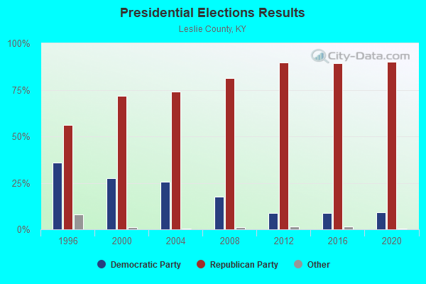
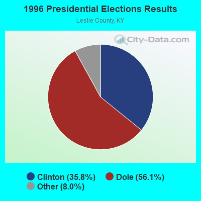
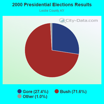
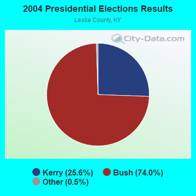
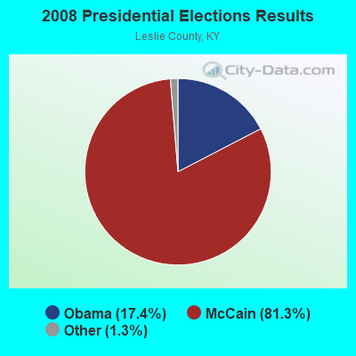
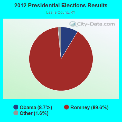
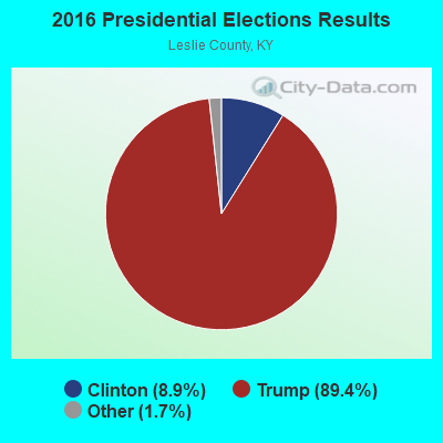
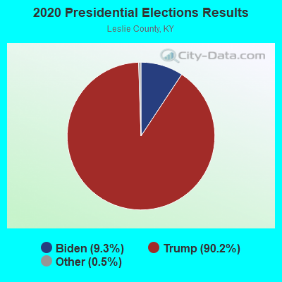
Graphs represent county-level data. Detailed 2008 Election Results
Religion statistics for Mozelle, KY (based on Leslie County data)
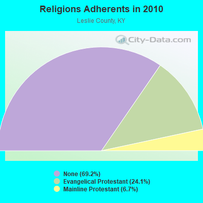
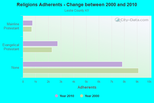
| Religion | Adherents | Congregations |
|---|---|---|
| Evangelical Protestant | 2,724 | 18 |
| Mainline Protestant | 757 | 9 |
| None | 7,829 | - |
Food Environment Statistics:
| Leslie County: | 5.11 / 10,000 pop. |
| State: | 2.19 / 10,000 pop. |
| Here: | 1.70 / 10,000 pop. |
| Kentucky: | 0.74 / 10,000 pop. |
| Leslie County: | 3.41 / 10,000 pop. |
| Kentucky: | 4.36 / 10,000 pop. |
| This county: | 13.6% |
| State: | 11.0% |
| Leslie County: | 34.3% |
| State: | 30.0% |
| Here: | 12.9% |
| State: | 15.9% |
Strongest AM radio stations in Mozelle:
- WFSR (970 AM; 5 kW; HARLAN, KY; Owner: EASTERN BROADCASTING COMPAY)
- WHLN (1410 AM; 5 kW; HARLAN, KY)
- WKVL (850 AM; daytime; 50 kW; KNOXVILLE, TN; Owner: HORNE RADIO, LLC)
- WKIC (1390 AM; 5 kW; HAZARD, KY)
- WKLB (1290 AM; 5 kW; MANCHESTER, KY; Owner: BARKER BROADCASTING COMPANY, INC.)
- WMIK (560 AM; 2 kW; MIDDLESBORO, KY; Owner: GATEWAY BROADCASTING, INC.)
- WMTC (730 AM; 5 kW; VANCLEVE, KY; Owner: THE KENTUCKY MOUNTAIN HOLINESS ASSN.)
- WEKG (810 AM; daytime; 5 kW; JACKSON, KY; Owner: INTERMOUNTAIN B/CING CO., INC.)
- WFGW (1010 AM; 50 kW; BLACK MOUNTAIN, NC; Owner: BLUE RIDGE BROADCASTING CORP.)
- WGOC (640 AM; 10 kW; BLOUNTVILLE, TN; Owner: CITADEL BROADCASTING COMPANY)
- WTCW (920 AM; 4 kW; WHITESBURG, KY; Owner: T.C.W. BROADCASTING , INC.)
- WLFJ (660 AM; daytime; 50 kW; GREENVILLE, SC; Owner: CLEAR CHANNEL BROADCASTING LICENSES, INC.)
- WHAS (840 AM; 50 kW; LOUISVILLE, KY; Owner: CLEAR CHANNEL BROADCASTING LICENSES, INC.)
Strongest FM radio stations in Mozelle:
- WTUK (105.1 FM; HARLAN, KY; Owner: EASTERN BROADCASTING COMPANY)
- WSGS (101.1 FM; HAZARD, KY; Owner: MOUNTAIN BROADCASTING SERVICE, INC.)
- WSEH (102.7 FM; CUMBERLAND, KY; Owner: CUMBERLAND CITY BROADCASTING, INC.)
- WEKH (90.9 FM; HAZARD, KY; Owner: EASTERN KENTUCKY UNIVERSITY)
- WZQQ (97.9 FM; HYDEN, KY; Owner: LESLIE COUNTY BROADCASTING, INC.)
- WJMD (104.7 FM; HAZARD, KY; Owner: HAZARD BROADCASTING SERVICES)
- WAXM (93.5 FM; BIG STONE GAP, VA; Owner: VALLEY BROADCASTING, INC.)
- WIFX-FM (94.3 FM; JENKINS, KY; Owner: LETCHER COUNTY BROADCASTING, INC)
- WXKQ-FM (103.9 FM; WHITESBURG, KY; Owner: T.C.W. BROADCASTING , INC.)
- WMIK-FM (92.7 FM; MIDDLESBORO, KY; Owner: GATEWAY BROADCASTING, INC.)
- WMMT (88.7 FM; WHITESBURG, KY; Owner: APPALSHOP, INCORPORATED)
- WRIL (106.3 FM; PINEVILLE, KY; Owner: PINE HILLS BROADCASTING, INC.)
- W223AA (92.5 FM; BIG STONE GAP, VA; Owner: VALLEY BROADCASTING, INC.)
- WTFM (98.5 FM; KINGSPORT, TN; Owner: HOLSTON VALLEY BROADCASTING CORP.)
- WJDT (106.5 FM; ROGERSVILLE, TN; Owner: C & S BROADCASTING)
- WDXC (102.3 FM; POUND, VA; Owner: WDXC RADIO, INC.)
- WTBK (105.7 FM; MANCHESTER, KY; Owner: MANCHESTER COMMUNICATIONS, INC.)
- WCTU (105.9 FM; TAZEWELL, TN; Owner: STAIR COMPANY, INC)
- WWLT (103.1 FM; MANCHESTER, KY; Owner: VERNON R. BALDWIN, INC.)
- WBGQ (100.7 FM; BULLS GAP, TN; Owner: CHEROKEE BROADCASTING)
TV broadcast stations around Mozelle:
- WYMT-TV (Channel 57; HAZARD, KY; Owner: WYMT LICENSEE CORP.)
- W24BT (Channel 24; TALBERT, KY; Owner: MS COMMUNICATIONS, LLC)
- WKHA (Channel 35; HAZARD, KY; Owner: KENTUCKY AUTHORITY FOR EDUCATIONAL TV)
- WAGV (Channel 44; HARLAN, KY; Owner: LIVING FAITH MINISTRIES, INC.)
- W31BU (Channel 31; TALBERT, KY; Owner: MS COMMUNICATIONS, LLC)
- W53BQ (Channel 53; TALBERT, KY; Owner: MS COMMUNICATIONS, LLC)
- W69ED (Channel 69; TALBERT, KY; Owner: MS COMMUNICATIONS, LLC)
- W26BK (Channel 26; TALBERT, KY; Owner: MS COMMUNICATIONS, LLC)
- W16BI (Channel 16; TALBERT, KY; Owner: MS COMMUNICATIONS, LLC)

Mozelle fatal accident list:
FCC Registered Antenna Towers:
2- William F Hays, 1900 New Forest Road (Lat: 36.998944 Lon: -83.422250), Type: 90.8, Overall height: 86 m, Registrant: Kentucky, Commonwealth Of Dba , William.Hays@ky.Gov, , Frank-fort, Phone: (502) 564-5397
- William F Hays, 1900 New Forest Road (Lat: 36.998944 Lon: -83.422250), Type: 90.8, Overall height: 86 m, Registrant: Kentucky, Commonwealth Of Dba , William.Hays@ky.Gov, , Frank-fort, Phone: (502) 564-5397
FCC Registered Broadcast Land Mobile Towers:
2- 1.3 Mi E On Hwy 421 (Lat: 36.983139 Lon: -83.433806), Call Sign: KEG734, Licensee ID: L00001846,
Assigned Frequencies: 453.300 MHz, 453.300 MHz, 453.550 MHz, 453.550 MHz, 453.900 MHz, 453.900 MHz, Grant Date: 03/15/2002, Expiration Date: 05/26/2012, Cancellation Date: 06/11/2002, Registrant: Kentucky, Commonwealth Of, 1240 Louisville Rd, Frankfort, KY 40601, Phone: (502) 227-8730
- 1900 New Forest Road (Lat: 36.998944 Lon: -83.422250), Type: Tower, Structure height: 86 m, Overall height: 90.8 m, Call Sign: WPMM482,
Assigned Frequencies: 155.062 MHz, Grant Date: 09/07/2023, Expiration Date: 09/17/2033, Certifier: Onzie Sizmore, Registrant: Leslie County 911, 24770 Hwy 421, Hyden, KY 41749, Phone: (606) 672-2986, Fax: (606) 672-2601, Email:
FCC Registered Microwave Towers:
1- 13-5ASHER-BE, 1900 New Forest Road (Lat: 36.998944 Lon: -83.422250), Type: Tower, Structure height: 86 m, Overall height: 90.8 m, Call Sign: WQHB759,
Assigned Frequencies: 6835.00 MHz, 6825.00 MHz, Grant Date: 04/28/2017, Expiration Date: 06/21/2027, Certifier: William F Hays, Registrant: Kentucky Emergency Warning System, 100 Minuteman Parkway, Building# 101, Frankfort, KY 40601, Phone: (502) 564-5397, Fax: (502) 564-6726, Email:
FCC Registered Amateur Radio Licenses:
1- Call Sign: KR4YP, Previous Call Sign: KD4YQI, Licensee ID: L00844485, Grant Date: 02/23/2024, Expiration Date: 04/19/2034, Certifier: Rick W Ervin, Registrant: Rick W Ervin, 9400 Hwy 421, Mozelle, KY 40858

- 70.3%Electricity
- 15.4%Coal or coke
- 7.0%Fuel oil, kerosene, etc.
- 4.4%Wood
- 1.4%Bottled, tank, or LP gas
- 0.8%Other fuel
- 0.7%No fuel used

- 44.9%Electricity
- 25.7%Coal or coke
- 11.7%Fuel oil, kerosene, etc.
- 8.4%Bottled, tank, or LP gas
- 7.0%Wood
- 2.3%Utility gas
Mozelle compared to Kentucky state average:
- Median household income below state average.
- Median house value significantly below state average.
- Black race population percentage significantly below state average.
- Hispanic race population percentage significantly below state average.
- Median age below state average.
- Foreign-born population percentage significantly below state average.
- Renting percentage below state average.
- Length of stay since moving in significantly above state average.
- Number of rooms per house significantly below state average.
- House age significantly below state average.
- Number of college students below state average.
- Percentage of population with a bachelor's degree or higher significantly below state average.