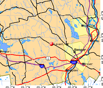
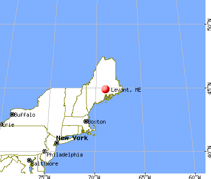
Levant, Maine
Submit your own pictures of this town and show them to the world
- OSM Map
- General Map
- Google Map
- MSN Map
Population change since 2000: +31.3%
| Males: 1,446 | |
| Females: 1,405 |
| Median resident age: | 37.9 years |
| Maine median age: | 43.0 years |
Zip codes: 04456.
| Levant: | $73,648 |
| ME: | $69,543 |
Estimated per capita income in 2022: $37,534 (it was $18,671 in 2000)
Levant town income, earnings, and wages data
Estimated median house or condo value in 2022: $220,916 (it was $84,900 in 2000)
| Levant: | $220,916 |
| ME: | $290,600 |
Mean prices in 2022: all housing units: $235,563; detached houses: $252,705; townhouses or other attached units: $267,749; in 2-unit structures: $255,332; in 3-to-4-unit structures: $815,300; in 5-or-more-unit structures: $185,873; mobile homes: $93,017; occupied boats, rvs, vans, etc.: $21,333
Detailed information about poverty and poor residents in Levant, ME
Compare current foreclosures near Levant, ME:
| Photo | Address | Area | Beds / Baths | Price | Details |
|---|---|---|---|---|---|

|
#1
Foxtail Ln
Levant, ME 04456
|
1,190 sq. feet
|
2 baths 3 beds |
show details | |

|
#2
Union St
Levant, ME 04456
|
1,538 sq. feet
|
1 baths 4 beds |
show details | |

|
#3
Century St
Brewer, ME 04412
|
1,652 sq. feet
|
2 baths 4 beds |
show details | |

|
#4
Ohio St
Bangor, ME 04401
|
1,628 sq. feet
|
1 baths 4 beds |
show details | |

|
#5
Warren St
Bangor, ME 04401
|
2,842 sq. feet
|
3 baths 5 beds |
show details | |

|
#6
Elm St
Bangor, ME 04401
|
1,718 sq. feet
|
2 baths 4 beds |
show details | |

|
#7
Main St
Bangor, ME 04401
|
2,232 sq. feet
|
2 baths 3 beds |
show details | |

|
#8
Fruit St
Bangor, ME 04401
|
1,224 sq. feet
|
1 baths 2 beds |
show details | |

|
#9
Church St
Brewer, ME 04412
|
2,548 sq. feet
|
2 baths 3 beds |
show details | |

|
#10
Hancock St
Bangor, ME 04401
|
1,736 sq. feet
|
1 baths 4 beds |
show details |
| Photo | Address | Area | Beds / Baths | Price | Details |
|---|---|---|---|---|---|

|
#11
E Summer St
Brewer, ME 04412
|
1,062 sq. feet
|
1 baths 2 beds |
show details | |

|
#12
Summer St
Hampden, ME 04444
|
864 sq. feet
|
1 baths 2 beds |
show details | |

|
#13
Riverview Ter
Brewer, ME 04412
|
1,144 sq. feet
|
1 baths 3 beds |
show details | |

|
#14
S Brewer Dr
Brewer, ME 04412
|
940 sq. feet
|
1 baths 2 beds |
show details | |

|
#15
Savage St
Bangor, ME 04401
|
1,582 sq. feet
|
2 baths 4 beds |
show details | |

|
#16
Jefferson St
Brewer, ME 04412
|
1,088 sq. feet
|
2 baths 3 beds |
show details | |

|
#17
Kirkland Rd
Old Town, ME 04468
|
864 sq. feet
|
1 baths 2 beds |
show details | |

|
#18
N Main St
Brewer, ME 04412
|
1,004 sq. feet
|
1 baths 3 beds |
show details | |

|
#19
Elm St
Newport, ME 04953
|
1,632 sq. feet
|
2 baths 5 beds |
show details | |

|
#20
Lunt Rd
Newport, ME 04953
|
1,274 sq. feet
|
1 baths 3 beds |
show details |
| Photo | Address | Area | Beds / Baths | Price | Details |
|---|---|---|---|---|---|

|
#21
Mainewood Ave
Orono, ME 04473
|
1,260 sq. feet
|
1 baths 3 beds |
show details | |

|
#22
Forest Ave
Orono, ME 04473
|
2,005 sq. feet
|
2 baths 4 beds |
show details | |

|
#23
Bennoch Rd
Old Town, ME 04468
|
1,244 sq. feet
|
3 baths 4 beds |
show details | |

|
#24
Main St
Bradley, ME 04411
|
1,944 sq. feet
|
2 baths 3 beds |
show details | |

|
#25
Lincoln St
Old Town, ME 04468
|
725 sq. feet
|
1 baths 3 beds |
show details | |

|
#26
Stillwater Ave
Old Town, ME 04468
|
1,961 sq. feet
|
2 baths 4 beds |
show details | |

|
#27
Greenbush Rd
Corinna, ME 04928
|
1,296 sq. feet
|
2 baths 3 beds |
show details | |

|
#28
Maple St
Bangor, ME 04401
|
1,926 sq. feet
|
3 baths 4 beds |
show details | |

|
#29
Billings Rd
Bangor, ME 04401
|
1,512 sq. feet
|
2 baths 3 beds |
show details | |

|
#30
Union St
Bangor, ME 04401
|
1,857 sq. feet
|
2 baths 3 beds |
show details |
| Photo | Address | Area | Beds / Baths | Price | Details |
|---|---|---|---|---|---|

|
#31
Kenduskeag Levant Rd
Kenduskeag, ME 04450
|
- sq. feet
|
2 baths 3 beds |
show details | |

|
#32
Wing Rd
Bangor, ME 04401
|
1,680 sq. feet
|
2 baths 3 beds |
show details | |

|
#33
Western Ave
Hampden, ME 04444
|
1,976 sq. feet
|
2 baths 4 beds |
show details | |

|
#34
Billings Rd
Bangor, ME 04401
|
864 sq. feet
|
2 baths 4 beds |
show details | |

|
#35
Upper Cross Rd
Hudson, ME 04449
|
1,344 sq. feet
|
2 baths 3 beds |
show details | |

|
#36
Western Ave
Hampden, ME 04444
|
1,825 sq. feet
|
1 baths 3 beds |
show details | |

|
#37
Main St
Corinth, ME 04427
|
1,573 sq. feet
|
2 baths 3 beds |
show details | |

|
#38
Bog Rd
Hampden, ME 04444
|
1,512 sq. feet
|
3 baths 5 beds |
show details | |

|
#39
Sugarloaf Ln
Bangor, ME 04401
|
1,421 sq. feet
|
2 baths 3 beds |
show details | |

|
#40
Allen St
Bangor, ME 04401
|
1,200 sq. feet
|
1 baths 3 beds |
show details |
| Photo | Address | Area | Beds / Baths | Price | Details |
|---|---|---|---|---|---|

|
#41
Grove St
Bangor, ME 04401
|
910 sq. feet
|
1 baths 3 beds |
show details | |

|
#42
Ichabod Ln
Hampden, ME 04444
|
960 sq. feet
|
1 baths 3 beds |
show details | |

|
#43
Summer St
Old Town, ME 04468
|
- sq. feet
|
- baths - beds |
show details | |

|
#44
S Smith Rd
Bradford, ME 04410
|
2,360 sq. feet
|
- baths - beds |
show details | |

|
#45
Union St
Bangor, ME 04401
|
924 sq. feet
|
- baths - beds |
show details | |

|
#46
Grist Mill Rd
Carmel, ME 04419
|
- sq. feet
|
- baths - beds |
show details | |

|
#47
Morison Ave
Corinth, ME 04427
|
- sq. feet
|
- baths - beds |
show details | |

|
#48
Broadway
Kenduskeag, ME 04450
|
- sq. feet
|
- baths - beds |
show details | |

|
#49
Karen St
Palmyra, ME 04965
|
- sq. feet
|
- baths - beds |
show details | |

|
Check over 1 million property listings on Foreclosure.com!
|
browse all offers | |||

- 2,73796.0%White alone
- 501.8%Two or more races
- 230.8%Hispanic
- 170.6%American Indian alone
- 160.6%Asian alone
- 70.2%Black alone
- 10.04%Other race alone

Races in Levant detailed stats: ancestries, foreign born residents, place of birth
According to our research of Maine and other state lists, there were 3 registered sex offenders living in Levant, Maine as of June 01, 2024.
The ratio of all residents to sex offenders in Levant is 950 to 1.
The ratio of registered sex offenders to all residents in this city is lower than the state average.
 Recent articles from our blog. Our writers, many of them Ph.D. graduates or candidates, create easy-to-read articles on a wide variety of topics.

 | Where to live? (21 replies) |
| Great Bangor suburb to live for families (19 replies) |
| Levant Maine (21 replies) |
| questions about bangor area help please! :) (23 replies) |
| Land near Bangor (27 replies) |
| Blueberries? (56 replies) |
Latest news from Levant, ME collected exclusively by city-data.com from local newspapers, TV, and radio stations
Ancestries: United States (20.7%), English (17.0%), French (14.9%), Irish (11.7%), French Canadian (5.3%), Scottish (4.9%).
Current Local Time: EST time zone
Incorporated on 06/14/1813
Elevation: 130 feet
Land area: 30.0 square miles.
Population density: 95 people per square mile (very low).
20 residents are foreign born
| This town: | 0.9% |
| Maine: | 2.9% |
| Levant town: | 1.3% ($1,069) |
| Maine: | 1.5% ($1,417) |
Nearest city with pop. 50,000+: Portland, ME  (105.1 miles , pop. 64,249).
Nearest city with pop. 200,000+: Boston, MA (205.7 miles , pop. 589,141).
Nearest city with pop. 1,000,000+: Bronx, NY (372.7 miles , pop. 1,332,650).
Nearest cities:
), ), ), ), ), ), Latitude: 44.88 N, Longitude: 68.99 W
Area code: 207


Single-family new house construction building permits:
- 2022: 15 buildings, average cost: $266,000
- 2021: 23 buildings, average cost: $221,700
- 2020: 12 buildings, average cost: $217,900
- 2019: 9 buildings, average cost: $158,300
- 2018: 4 buildings, average cost: $249,800
- 2017: 8 buildings, average cost: $186,900
- 2016: 6 buildings, average cost: $157,500
- 2015: 7 buildings, average cost: $155,000
- 2014: 13 buildings, average cost: $101,400
- 2013: 15 buildings, average cost: $139,300
- 2012: 18 buildings, average cost: $121,100
- 2011: 12 buildings, average cost: $134,800
- 2010: 8 buildings, average cost: $131,800
- 2009: 5 buildings, average cost: $104,000
- 2008: 13 buildings, average cost: $125,400
- 2007: 37 buildings, average cost: $131,800
- 2006: 33 buildings, average cost: $101,100
- 2005: 23 buildings, average cost: $123,800
- 2004: 30 buildings, average cost: $105,700
- 2003: 28 buildings, average cost: $105,700
- 2002: 12 buildings, average cost: $88,100
- 2001: 18 buildings, average cost: $72,700
- 2000: 14 buildings, average cost: $71,200
- 1999: 18 buildings, average cost: $70,100
- 1998: 12 buildings, average cost: $62,800
- 1997: 10 buildings, average cost: $56,000


| Here: | 3.2% |
| Maine: | 3.4% |


- Health care (15.2%)
- Construction (8.1%)
- Educational services (7.3%)
- Public administration (5.3%)
- Accommodation & food services (4.6%)
- Motor vehicle & parts dealers (4.2%)
- Social assistance (3.9%)

- Construction (14.6%)
- Motor vehicle & parts dealers (5.9%)
- Public administration (5.3%)
- Agriculture, forestry, fishing & hunting (5.0%)
- Educational services (5.0%)
- Professional, scientific, technical services (4.1%)
- Health care (3.8%)

- Health care (27.6%)
- Educational services (9.9%)
- Social assistance (7.3%)
- Accommodation & food services (5.4%)
- Public administration (5.2%)
- Department & other general merchandise stores (3.9%)
- Administrative & support & waste management services (3.9%)

- Other office and administrative support workers, including supervisors (4.6%)
- Building and grounds cleaning and maintenance occupations (3.7%)
- Driver/sales workers and truck drivers (3.5%)
- Other management occupations, except farmers and farm managers (3.4%)
- Electrical equipment mechanics and other installation, maintenance, and repair workers, including supervisors (3.4%)
- Other production occupations, including supervisors (3.3%)
- Metal workers and plastic workers (3.2%)

- Driver/sales workers and truck drivers (6.7%)
- Electrical equipment mechanics and other installation, maintenance, and repair workers, including supervisors (6.2%)
- Metal workers and plastic workers (5.7%)
- Other production occupations, including supervisors (4.6%)
- Vehicle and mobile equipment mechanics, installers, and repairers (4.6%)
- Material recording, scheduling, dispatching, and distributing workers (3.8%)
- Supervisors, construction and extraction workers (3.6%)

- Other office and administrative support workers, including supervisors (7.6%)
- Secretaries and administrative assistants (5.6%)
- Registered nurses (5.0%)
- Cashiers (4.8%)
- Building and grounds cleaning and maintenance occupations (4.7%)
- Health technologists and technicians (4.3%)
- Nursing, psychiatric, and home health aides (4.1%)
Average climate in Levant, Maine
Based on data reported by over 4,000 weather stations


(lower is better)

Air Quality Index (AQI) level in 2023 was 61.1. This is about average.
| City: | 61.1 |
| U.S.: | 72.6 |

Ozone [ppb] level in 2023 was 33.6. This is about average. Closest monitor was 10.0 miles away from the city center.
| City: | 33.6 |
| U.S.: | 33.3 |

Particulate Matter (PM2.5) [µg/m3] level in 2023 was 5.62. This is significantly better than average. Closest monitor was 11.3 miles away from the city center.
| City: | 5.62 |
| U.S.: | 8.11 |
Earthquake activity:
Levant-area historical earthquake activity is significantly above Maine state average. It is 81% smaller than the overall U.S. average.On 4/20/2002 at 10:50:47, a magnitude 5.3 (5.3 ML, Depth: 3.0 mi, Class: Moderate, Intensity: VI - VII) earthquake occurred 232.9 miles away from Levant center
On 10/16/2012 at 23:12:25, a magnitude 4.7 (4.7 ML, Depth: 10.0 mi, Class: Light, Intensity: IV - V) earthquake occurred 121.1 miles away from Levant center
On 4/20/2002 at 10:50:47, a magnitude 5.2 (5.2 MB, 4.2 MS, 5.2 MW, 5.0 MW) earthquake occurred 234.2 miles away from Levant center
On 10/7/1983 at 10:18:46, a magnitude 5.3 (5.1 MB, 5.3 LG, 5.1 ML) earthquake occurred 272.1 miles away from the city center
On 1/19/1982 at 00:14:42, a magnitude 4.7 (4.5 MB, 4.7 MD, 4.5 LG) earthquake occurred 160.8 miles away from the city center
On 2/26/1999 at 03:38:43, a magnitude 3.8 (3.8 LG, Depth: 2.0 mi, Class: Light, Intensity: II - III) earthquake occurred 37.9 miles away from the city center
Magnitude types: regional Lg-wave magnitude (LG), body-wave magnitude (MB), duration magnitude (MD), local magnitude (ML), surface-wave magnitude (MS), moment magnitude (MW)
Natural disasters:
The number of natural disasters in Penobscot County (19) is greater than the US average (15).Major Disasters (Presidential) Declared: 11
Emergencies Declared: 7
Causes of natural disasters: Floods: 9, Storms: 8, Snows: 5, Heavy Rains: 2, Blizzard: 1, Hurricane: 1, Ice Storm: 1, Snowfall: 1, Wind: 1, Winter Storm: 1, Other: 2 (Note: some incidents may be assigned to more than one category).

Hospitals and medical centers near Levant:
- BANGOR AREA VISITING NURSES (Home Health Center, about 10 miles away; BANGOR, ME)
- HOSPICE OF EASTERN MAINE (Hospital, about 10 miles away; BANGOR, ME)
- BANGOR NURSING AND REHABILITATION (Nursing Home, about 11 miles away; BANGOR, ME)
- KINDRED NURSING AND REHABILITATION-WESTGATE (Nursing Home, about 11 miles away; BANGOR, ME)
- ROSS MANOR (Nursing Home, about 12 miles away; BANGOR, ME)
- ST JOSEPH HOSPICE (Hospital, about 12 miles away; BANGOR, ME)
- ST JOSEPH HOSPITAL Acute Care Hospitals (about 12 miles away; BANGOR, ME)
Airports located in Levant:
- Griffin Field Airport (PG1) (Runways: 2, Itinerant Ops: 50, Local Ops: 200)
- Terra B & B Airport (ME35) (Runways: 1)
Colleges/universities with over 2000 students nearest to Levant:
- Husson University (about 11 miles; Bangor, ME; Full-time enrollment: 2,421)
- University of Maine (about 16 miles; Orono, ME; FT enrollment: 8,931)
- University of Maine at Augusta (about 55 miles; Augusta, ME; FT enrollment: 3,204)
- University of Maine at Farmington (about 59 miles; Farmington, ME; FT enrollment: 2,036)
- Saint Joseph's College of Maine (about 104 miles; Standish, ME; FT enrollment: 2,010)
- Southern Maine Community College (about 105 miles; South Portland, ME; FT enrollment: 4,666)
- University of Southern Maine (about 106 miles; Portland, ME; FT enrollment: 6,647)
Public elementary/middle school in Levant:
- SUZANNE M SMITH ELEMENTARY SCHOOL (Location: 169 SOUTH LEVANT ROAD, Grades: PK-5)
Points of interest:
Notable location: Levant Fire and Rescue Department (A). Display/hide its location on the map
Churches in Levant include: West Levant Church of God (A), South Levant Baptist Church (B), Levant Village Baptist Church (C). Display/hide their locations on the map
Cemeteries: Lucas Cemetery (1), Waughn Cemetery (2), Page Cemetery (3). Display/hide their locations on the map
Lake: Harveys Pond (A). Display/hide its location on the map
Birthplace of: Jesse Keith - College basketball player (Maine Black Bears).
Drinking water stations with addresses in Levant and their reported violations in the past:
LEVANT CORNER STORE (Population served: 200, Groundwater):Past health violations:
- MCL, Monthly (TCR) - In AUG-2005, Contaminant: Coliform. Follow-up actions: St Public Notif requested (AUG-25-2005), St Violation/Reminder Notice (AUG-25-2005), St Public Notif received (2 times from SEP-22-2005 to SEP-22-2005), St Compliance achieved (FEB-01-2006)
- MCL, Monthly (TCR) - In APR-2005, Contaminant: Coliform. Follow-up actions: St Violation/Reminder Notice (APR-22-2005), St Public Notif requested (APR-22-2005), St Public Notif received (2 times from MAY-04-2005 to MAY-04-2005), St Compliance achieved (MAY-26-2005)
| This town: | 2.6 people |
| Maine: | 2.3 people |
| This town: | 74.0% |
| Whole state: | 62.9% |
| This town: | 11.2% |
| Whole state: | 9.4% |
Likely homosexual households (counted as self-reported same-sex unmarried-partner households)
- Lesbian couples: 0.4% of all households
- Gay men: 0.2% of all households
| This town: | 10.6% |
| Whole state: | 10.9% |
| This town: | 5.1% |
| Whole state: | 4.1% |
For population 15 years and over in Levant:

- Never married: 19.8%
- Now married: 66.5%
- Separated: 1.0%
- Widowed: 3.5%
- Divorced: 9.3%
For population 25 years and over in Levant:
- High school or higher: 84.0%
- Bachelor's degree or higher: 14.0%
- Graduate or professional degree: 3.9%
- Unemployed: 3.7%
- Mean travel time to work (commute): 28.0 minutes


| Here: | 10.2 |
| Maine average: | 11.2 |


Graphs represent county-level data. Detailed 2008 Election Results
Religion statistics for Levant, ME (based on Penobscot County data)


| Religion | Adherents | Congregations |
|---|---|---|
| Catholic | 16,581 | 15 |
| Mainline Protestant | 9,715 | 59 |
| Evangelical Protestant | 7,523 | 80 |
| Other | 2,936 | 22 |
| Orthodox | 300 | 1 |
| None | 116,868 | - |
Food Environment Statistics:
| This county: | 2.29 / 10,000 pop. |
| Maine: | 2.80 / 10,000 pop. |
| Penobscot County: | 0.13 / 10,000 pop. |
| Maine: | 0.14 / 10,000 pop. |
| This county: | 2.56 / 10,000 pop. |
| State: | 2.20 / 10,000 pop. |
| Penobscot County: | 5.72 / 10,000 pop. |
| Maine: | 5.75 / 10,000 pop. |
| Here: | 7.41 / 10,000 pop. |
| Maine: | 11.02 / 10,000 pop. |
| This county: | 9.0% |
| Maine: | 8.2% |
| Here: | 28.0% |
| State: | 25.0% |
Strongest AM radio stations in Levant:
- WZON (620 AM; 5 kW; BANGOR, ME; Owner: THE ZONE CORPORATION)
- WABI (910 AM; 5 kW; BANGOR, ME; Owner: CLEAR CHANNEL BROADCASTING LICENSES, INC.)
- WSKW (1160 AM; 10 kW; SKOWHEGAN, ME; Owner: MOUNTAIN WIRELESS, INCORPORATED)
- WNZS (1340 AM; 1 kW; VEAZIE, ME; Owner: WATERFRONT COMMUNICATIONS INC.)
- WDEA (1370 AM; 5 kW; ELLSWORTH, ME; Owner: CUMULUS LICENSING CORP.)
- WTME (780 AM; 10 kW; RUMFORD, ME; Owner: MOUNTAIN VALLEY BROADCASTING, INC.)
- WRKO (680 AM; 50 kW; BOSTON, MA; Owner: ENTERCOM BOSTON LICENSE, LLC)
- WEEI (850 AM; 50 kW; BOSTON, MA; Owner: ENTERCOM BOSTON LICENSE, LLC)
- WBZ (1030 AM; 50 kW; BOSTON, MA; Owner: INFINITY BROADCASTING OPERATIONS, INC.)
- WFAU (1280 AM; 5 kW; GARDINER, ME; Owner: CAPSTAR TX LIMITED PARTNERSHIP)
- WCRN (830 AM; 50 kW; WORCESTER, MA; Owner: CARTER BROADCASTING CORPORATION)
- WNNZ (640 AM; 50 kW; WESTFIELD, MA; Owner: CLEAR CHANNEL BROADCASTING LICENSES, INC.)
- WCHP (760 AM; 35 kW; CHAMPLAIN, NY; Owner: CHAMPLAIN RADIO, INC.)
Strongest FM radio stations in Levant:
- WWBX (97.1 FM; BANGOR, ME; Owner: CLEAR CHANNEL BROADCASTING LICENSES, INC.)
- WQCB (106.5 FM; BREWER, ME; Owner: CUMULUS LICENSING CORP.)
- WBFB (104.7 FM; BELFAST, ME; Owner: CLEAR CHANNEL BROADCASTING LICENSES, INC.)
- WKIT-FM (100.3 FM; BREWER, ME; Owner: THE ZONE CORPORATION)
- WVOM (103.9 FM; HOWLAND, ME; Owner: CLEAR CHANNEL BROADCASTING LICENSES, INC.)
- WBZN (107.3 FM; OLD TOWN, ME; Owner: CUMULUS LICENSING CORP.)
- WWMJ (95.7 FM; ELLSWORTH, ME; Owner: CUMULUS LICENSING CORP.)
- WGUY (102.1 FM; DEXTER, ME; Owner: CONCORD MEDIA GROUP, INC.)
- WHCF (88.5 FM; BANGOR, ME; Owner: BANGOR BAPTIST CHURCH)
- WMEH (90.9 FM; BANGOR, ME; Owner: MAINE PUBLIC BROADCASTING CORPORATION)
- WEZQ (92.9 FM; BANGOR, ME; Owner: CUMULUS LICENSING CORP.)
- WFZX (101.7 FM; SEARSPORT, ME; Owner: CLEAR CHANNEL BROADCASTING LICENSES, INC.)
- WTOS-FM (105.1 FM; SKOWHEGAN, ME; Owner: CAPSTAR TX LIMITED PARTNERSHIP)
- WJCX (99.5 FM; PITTSFIELD, ME; Owner: CSN INTERNATIONAL)
- WERU-FM (89.9 FM; BLUE HILL, ME; Owner: SALT POND COMMUNITY B/C COMPANY)
- WMEP (90.5 FM; CAMDEN, ME; Owner: MAINE PUBLIC BROADCASTING CORP.)
- WQSS (102.5 FM; CAMDEN, ME; Owner: CLEAR CHANNEL BROADCASTING LICENSES, INC.)
- WCTB (93.5 FM; FAIRFIELD, ME; Owner: MOUNTAIN WIRELESS, INC.)
- WDME-FM (103.1 FM; DOVER-FOXCROFT, ME; Owner: THE ZONE CORPORATION)
- WMEB-FM (91.9 FM; ORONO, ME; Owner: UNIVERSITY OF MAINE SYSTEM)
TV broadcast stations around Levant:
- WABI-TV (Channel 5; BANGOR, ME; Owner: COMMUNITY BROADCASTING SERVICE)
- W36CK (Channel 36; BANGOR, ME; Owner: TRINITY BROADCASTING NETWORK)
- WLBZ (Channel 2; BANGOR, ME; Owner: PACIFIC AND SOUTHERN COMPANY, INC.)
- WCKD-LP (Channel 30; BANGOR/DEDHAM, ME; Owner: J. MCLEOD, ME FAMILY B/CING., INC.)
- WBGR-LP (Channel 33; BANGOR/DEDHAM, ME; Owner: MAINE FAMILY BROADCASTING, INC.)
- WMEB-TV (Channel 12; ORONO, ME; Owner: MAINE PUBLIC BROADCASTING CORPORATION)
- W66CL (Channel 66; BANGOR, ME; Owner: MS COMMUNICATIONS, LLC)

Levant fatal accident list:
May 26, 2009 07:35 PM, Sr-222, Stetson Road East, Lat: 44.902639, Lon: -69.011136, Vehicles: 3, Persons: 9, Fatalities: 1
Jul 24, 2004 02:30 AM, Kenduskeag Road, Vehicles: 1, Persons: 3, Fatalities: 1, Drunk persons involved: 1
Dec 27, 1998 01:55 PM, Avenue Road, Vehicles: 1, Persons: 1, Fatalities: 1
- National Bridge Inventory (NBI) Statistics
- 6Number of bridges
- 30ft / 8.6mTotal length
- 8,017Total average daily traffic
- 398Total average daily truck traffic
- 11,908Total future (year 2036) average daily traffic
FCC Registered Broadcast Land Mobile Towers:
2- Fire Sta Main Rd (Lat: 44.703417 Lon: -68.932806), Call Sign: KRT77, Licensee ID: L00046646,
Assigned Frequencies: 158.760 MHz, Grant Date: 03/04/2014, Expiration Date: 05/23/2024, Registrant: County Of Penobscot
- Fire Station On Sr 222 (Lat: 44.868667 Lon: -68.929472), Call Sign: KWV587,
Assigned Frequencies: 155.820 MHz, 155.895 MHz, Grant Date: 08/03/2004, Expiration Date: 08/02/2014, Cancellation Date: 10/04/2014, Registrant: City Of Levant, 3917 Union St., Levant, ME 04456, Phone: (207) 884-7574, Email:
FCC Registered Amateur Radio Licenses:
16 (See the full list of FCC Registered Amateur Radio Licenses in Levant)FAA Registered Aircraft:
13 (See the full list of FAA Registered Aircraft in Levant)2002 - 2018 National Fire Incident Reporting System (NFIRS) incidents
- Fire incident types reported to NFIRS in Levant, ME
- 11167.3%Structure Fires
- 3923.6%Outside Fires
- 148.5%Mobile Property/Vehicle Fires
- 10.6%Other
 According to the data from the years 2002 - 2018 the average number of fires per year is 10. The highest number of fire incidents - 31 took place in 2016, and the least - 2 in 2002. The data has a rising trend.
 When looking into fire subcategories, the most incidents belonged to: Structure Fires (67.3%), and Outside Fires (23.6%).
- 88.9%Fuel oil, kerosene, etc.
- 7.8%Wood
- 1.7%Bottled, tank, or LP gas
- 1.6%Electricity

- 88.9%Fuel oil, kerosene, etc.
- 4.4%Wood
- 3.3%Bottled, tank, or LP gas
- 3.3%No fuel used
Levant compared to Maine state average:
- Unemployed percentage significantly below state average.
- Black race population percentage significantly below state average.
- Hispanic race population percentage below state average.
- Median age below state average.
- Foreign-born population percentage significantly below state average.
- Renting percentage below state average.
- Length of stay since moving in significantly above state average.
- Number of rooms per house significantly below state average.
- House age significantly below state average.
- Percentage of population with a bachelor's degree or higher below state average.

|
Total of 1 patent application in 2008-2024.