How, Wisconsin
Submit your own pictures of this town and show them to the world
- OSM Map
- Google Map
- MSN Map
Population change since 2000: -8.3%
| Males: 274 | |
| Females: 242 |
| Median resident age: | 46.7 years |
| Wisconsin median age: | 42.6 years |
Zip codes: 54174.
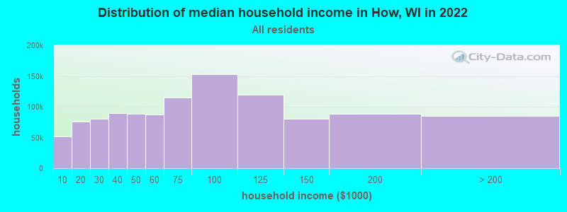
| How: | $68,565 |
| WI: | $70,996 |
Estimated per capita income in 2022: $30,200 (it was $15,447 in 2000)
How town income, earnings, and wages data
Estimated median house or condo value in 2022: $203,537 (it was $85,900 in 2000)
| How: | $203,537 |
| WI: | $252,800 |
Detailed information about poverty and poor residents in How, WI
Compare current foreclosures near How, WI:
| Photo | Address | Area | Beds / Baths | Price | Details |
|---|---|---|---|---|---|

|
#1
N Main St
Oconto Falls, WI 54154
|
- sq. feet
|
- baths - beds |
$24,900
|
show details |

|
#2
Lake Dr
Shawano, WI 54166
|
- sq. feet
|
- baths - beds |
show details | |

|
#3
County Road Mmm Lot 5
Shawano, WI 54166
|
- sq. feet
|
- baths - beds |
show details | |

|
#4
W 10th Rd
Pound, WI 54161
|
- sq. feet
|
- baths - beds |
show details | |

|
#5
W 6th Rd
Pound, WI 54161
|
- sq. feet
|
- baths - beds |
show details | |

|
#6
County Road M
Coleman, WI 54112
|
- sq. feet
|
- baths - beds |
show details | |

|
#7
W Sandy Dr, Lot 10
Shawano, WI 54166
|
- sq. feet
|
- baths - beds |
show details | |

|
#8
Curt Black Rd
Shawano, WI 54166
|
- sq. feet
|
- baths - beds |
show details | |

|
#9
Estates Ln Apt 5
Shawano, WI 54166
|
- sq. feet
|
- baths - beds |
show details | |

|
#10
Old Lake Ln
Shawano, WI 54166
|
- sq. feet
|
- baths - beds |
show details |
| Photo | Address | Area | Beds / Baths | Price | Details |
|---|---|---|---|---|---|

|
#11
Main Ln
Mountain, WI 54149
|
- sq. feet
|
- baths - beds |
show details | |

|
#12
Balsam Rd
Cecil, WI 54111
|
- sq. feet
|
- baths - beds |
show details | |

|
#13
Nabor Rd
Cecil, WI 54111
|
- sq. feet
|
- baths - beds |
show details | |

|
#14
Chrissie Cir
Shawano, WI 54166
|
- sq. feet
|
- baths - beds |
show details | |

|
#15
Hidden Pine Ln
Shawano, WI 54166
|
- sq. feet
|
- baths - beds |
show details | |

|
#16
Green Bay Ave
Oconto Falls, WI 54154
|
- sq. feet
|
- baths - beds |
show details | |

|
#17
Old Keshena Rd, Apt 3
Shawano, WI 54166
|
- sq. feet
|
- baths - beds |
show details | |

|
#18
Eagle Dr
Oconto Falls, WI 54154
|
- sq. feet
|
- baths - beds |
show details | |

|
#19
Depot Rapids Ln # 219
Mountain, WI 54149
|
- sq. feet
|
- baths - beds |
show details | |

|
#20
County Road M
Keshena, WI 54135
|
- sq. feet
|
- baths - beds |
show details |
| Photo | Address | Area | Beds / Baths | Price | Details |
|---|---|---|---|---|---|

|
#21
Elm Ave
Shawano, WI 54166
|
- sq. feet
|
- baths - beds |
show details | |

|
#22
Robin Ln
Oconto Falls, WI 54154
|
- sq. feet
|
- baths - beds |
show details | |

|
#23
Sherrie Ln
Gillett, WI 54124
|
- sq. feet
|
- baths - beds |
show details | |

|
#24
Woodland Ave
Oconto Falls, WI 54154
|
- sq. feet
|
- baths - beds |
show details | |

|
#25
N Washington St
Oconto Falls, WI 54154
|
- sq. feet
|
- baths - beds |
show details | |

|
#26
N Washington St
Oconto Falls, WI 54154
|
- sq. feet
|
- baths - beds |
show details | |

|
#27
S Main St
Oconto Falls, WI 54154
|
- sq. feet
|
- baths - beds |
show details | |

|
#28
Robin Ln
Oconto Falls, WI 54154
|
- sq. feet
|
- baths - beds |
show details | |

|
#29
Central Rd
Suring, WI 54174
|
- sq. feet
|
- baths - beds |
show details | |

|
#30
N Adams St
Oconto Falls, WI 54154
|
- sq. feet
|
- baths - beds |
show details |
| Photo | Address | Area | Beds / Baths | Price | Details |
|---|---|---|---|---|---|

|
#31
County Road Aa
Suring, WI 54174
|
- sq. feet
|
- baths - beds |
show details | |

|
#32
E Freeborn St
Cecil, WI 54111
|
- sq. feet
|
- baths - beds |
show details | |

|
#33
County Road Hh
Gillett, WI 54124
|
- sq. feet
|
- baths - beds |
show details | |

|
#34
County Road Z
Pound, WI 54161
|
- sq. feet
|
- baths - beds |
show details | |

|
#35
W Main St
Gillett, WI 54124
|
- sq. feet
|
- baths - beds |
show details | |

|
#36
N Mckenzie St # A
Gillett, WI 54124
|
- sq. feet
|
- baths - beds |
show details | |

|
#37
Warrington Lake Ln
Gillett, WI 54124
|
- sq. feet
|
- baths - beds |
show details | |

|
#38
Jacklin Ct
Suring, WI 54174
|
- sq. feet
|
- baths - beds |
show details | |

|
#39
State Highway 32 N
Gillett, WI 54124
|
- sq. feet
|
- baths - beds |
show details | |

|
#40
Four Towns Rd
Gillett, WI 54124
|
- sq. feet
|
- baths - beds |
show details |
| Photo | Address | Area | Beds / Baths | Price | Details |
|---|---|---|---|---|---|

|
#41
S Washington St
Oconto Falls, WI 54154
|
- sq. feet
|
- baths - beds |
show details | |

|
Check over 1 million property listings on Foreclosure.com!
|
browse all offers | |||

- 48193.2%White alone
- 163.1%Hispanic
- 142.7%American Indian alone
- 40.8%Two or more races
- 10.2%Other race alone

Races in How detailed stats: ancestries, foreign born residents, place of birth
 Recent articles from our blog. Our writers, many of them Ph.D. graduates or candidates, create easy-to-read articles on a wide variety of topics.
Ancestries: German (69.3%), Polish (7.8%), Irish (6.7%), English (5.5%), Swedish (5.0%), Danish (4.3%).
Current Local Time: CST time zone
Land area: 34.9 square miles.
Population density: 15 people per square mile (very low).
2 residents are foreign born
| This town: | 0.4% |
| Wisconsin: | 3.6% |
| How town: | 1.1% ($968) |
| Wisconsin: | 2.0% ($2,245) |
Nearest city with pop. 50,000+: Green Bay, WI  (39.2 miles , pop. 102,313).
Nearest city with pop. 200,000+: Milwaukee, WI (136.7 miles , pop. 596,974).
Nearest city with pop. 1,000,000+: Chicago, IL (221.7 miles , pop. 2,896,016).
Nearest cities:
), ), ), ), ), ), )Latitude: 45.00 N, Longitude: 88.43 W
Area code commonly used in this area: 920
| Here: | 3.1% |
| Wisconsin: | 2.7% |

- Agriculture, forestry, fishing & hunting (23.0%)
- Furniture & related product manufacturing (13.1%)
- Construction (8.6%)
- Health care (5.2%)
- Educational services (4.8%)
- Transportation equipment (4.5%)
- Paper (4.1%)

- Agriculture, forestry, fishing & hunting (30.4%)
- Construction (14.6%)
- Furniture & related product manufacturing (11.4%)
- Food (5.7%)
- Paper (5.1%)
- Wood products (3.2%)
- Repair & maintenance (3.2%)

- Furniture & related product manufacturing (15.0%)
- Agriculture, forestry, fishing & hunting (14.3%)
- Health care (11.3%)
- Educational services (8.3%)
- Transportation equipment (6.8%)
- Accommodation & food services (5.3%)
- Food & beverage stores (3.8%)

- Farmers and farm managers (15.5%)
- Agricultural workers, including supervisors (6.5%)
- Other production occupations, including supervisors (6.5%)
- Electrical equipment mechanics and other installation, maintenance, and repair workers, including supervisors (5.2%)
- Other sales and related occupations, including supervisors (3.8%)
- Driver/sales workers and truck drivers (3.8%)
- Laborers and material movers, hand (3.4%)

- Farmers and farm managers (21.5%)
- Electrical equipment mechanics and other installation, maintenance, and repair workers, including supervisors (8.2%)
- Agricultural workers, including supervisors (7.6%)
- Driver/sales workers and truck drivers (7.0%)
- Other production occupations, including supervisors (7.0%)
- Metal workers and plastic workers (5.1%)
- Other sales and related occupations, including supervisors (4.4%)

- Farmers and farm managers (8.3%)
- Other production occupations, including supervisors (6.0%)
- Textile, apparel, and furnishings workers (5.3%)
- Woodworkers (5.3%)
- Agricultural workers, including supervisors (5.3%)
- Other healthcare support occupations (5.3%)
- Preschool, kindergarten, elementary, and middle school teachers (4.5%)
Average climate in How, Wisconsin
Based on data reported by over 4,000 weather stations


Tornado activity:
How-area historical tornado activity is slightly below Wisconsin state average. It is 20% smaller than the overall U.S. average.
On 8/19/1968, a category F4 (max. wind speeds 207-260 mph) tornado 17.9 miles away from the How town center killed 2 people and injured 3 people and caused between $500,000 and $5,000,000 in damages.
On 4/27/1984, a category F4 tornado 38.5 miles away from the town center killed one person and injured 19 people and caused between $500,000 and $5,000,000 in damages.
Earthquake activity:
How-area historical earthquake activity is significantly above Wisconsin state average. It is 82% smaller than the overall U.S. average.On 5/2/2015 at 16:23:07, a magnitude 4.2 (4.2 MW, Depth: 2.8 mi, Class: Light, Intensity: IV - V) earthquake occurred 243.1 miles away from How center
On 6/28/2004 at 06:10:52, a magnitude 4.2 (4.2 MW, Depth: 6.2 mi) earthquake occurred 246.0 miles away from How center
On 2/10/2010 at 09:59:35, a magnitude 3.8 (3.8 MW, Depth: 6.2 mi, Class: Light, Intensity: II - III) earthquake occurred 209.6 miles away from How center
On 1/31/1986 at 16:46:43, a magnitude 5.0 (5.0 MB, Class: Moderate, Intensity: VI - VII) earthquake occurred 434.5 miles away from the city center
On 7/9/1975 at 14:54:15, a magnitude 4.6 (4.6 MB) earthquake occurred 372.9 miles away from How center
On 9/25/1998 at 19:52:52, a magnitude 5.2 (4.8 MB, 4.3 MS, 5.2 LG, 4.5 MW, Depth: 3.1 mi) earthquake occurred 471.5 miles away from the city center
Magnitude types: regional Lg-wave magnitude (LG), body-wave magnitude (MB), surface-wave magnitude (MS), moment magnitude (MW)
Natural disasters:
The number of natural disasters in Oconto County (5) is a lot smaller than the US average (15).Major Disasters (Presidential) Declared: 2
Emergencies Declared: 2
Causes of natural disasters: Floods: 2, Storms: 2, Drought: 1, Hurricane: 1, Tornado: 1, Wind: 1, Other: 1 (Note: some incidents may be assigned to more than one category).
Hospitals and medical centers near How:
- WOODLAND VILLAGE NURSING HOME (Nursing Home, about 3 miles away; SURING, WI)
- WOODLAND VILLAGE HOME HEALTH (Home Health Center, about 3 miles away; SURING, WI)
- WOODLANDS OF GILLETT (Nursing Home, about 10 miles away; GILLETT, WI)
- SHARPE CARE NURSING AND REHABILITATION CENTER, LLC (Nursing Home, about 16 miles away; OCONTO FALLS, WI)
Colleges/universities with over 2000 students nearest to How:
- Northeast Wisconsin Technical College (about 37 miles; Green Bay, WI; Full-time enrollment: 6,069)
- University of Wisconsin-Green Bay (about 41 miles; Green Bay, WI; FT enrollment: 5,415)
- Saint Norbert College (about 43 miles; De Pere, WI; FT enrollment: 2,324)
- Fox Valley Technical College (about 50 miles; Appleton, WI; FT enrollment: 5,682)
- Lawrence University (about 52 miles; Appleton, WI; FT enrollment: 2,821)
- Northcentral Technical College (about 60 miles; Wausau, WI; FT enrollment: 3,356)
- University of Wisconsin-Stevens Point (about 65 miles; Stevens Point, WI; FT enrollment: 9,089)
Points of interest:
Church in How: Saint Johns Lutheran Church (A). Display/hide its location on the map
Cemeteries: Saint Johns Cemetery (1), Saint Michaels Cemetery (2), Pleasant Hill Cemetery (3), Riverside Cemetery (4). Display/hide their locations on the map
Lakes: Wiscobee Lake (A), Grignon Lake (B). Display/hide their locations on the map
Streams, rivers, and creeks: Peshtigo Brook (A), Pecore Creek (B), Hayes Creek (C), North Branch Oconto River (D), South Branch Oconto River (E). Display/hide their locations on the map
| This town: | 2.4 people |
| Wisconsin: | 2.4 people |
| This town: | 68.8% |
| Whole state: | 64.4% |
| This town: | 3.7% |
| Whole state: | 7.3% |
No gay or lesbian households reported
| This town: | 7.7% |
| Whole state: | 8.7% |
| This town: | 4.3% |
| Whole state: | 3.7% |
For population 15 years and over in How:

- Never married: 22.4%
- Now married: 68.5%
- Separated: 0.0%
- Widowed: 4.7%
- Divorced: 4.5%
For population 25 years and over in How:
- High school or higher: 83.2%
- Bachelor's degree or higher: 6.7%
- Graduate or professional degree: 0.5%
- Unemployed: 4.9%
- Mean travel time to work (commute): 22.4 minutes


| Here: | 7.8 |
| Wisconsin average: | 11.0 |
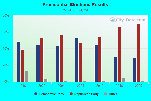
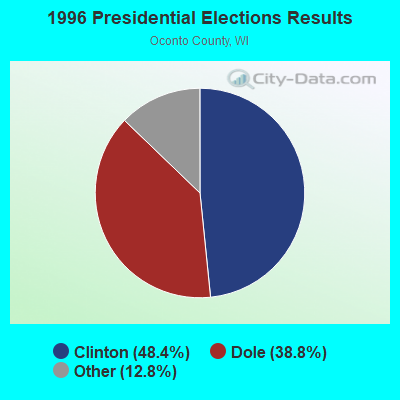
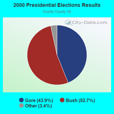
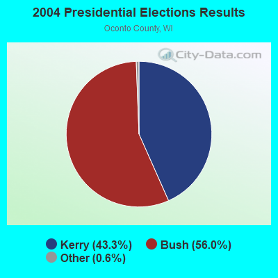
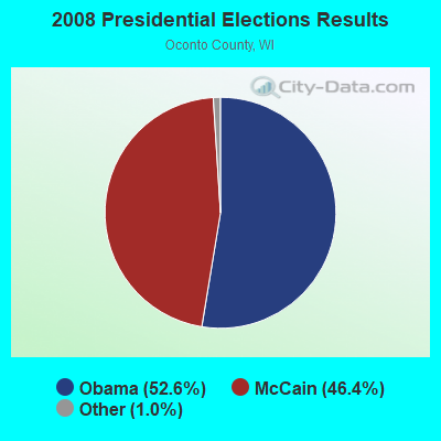
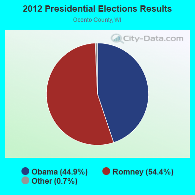
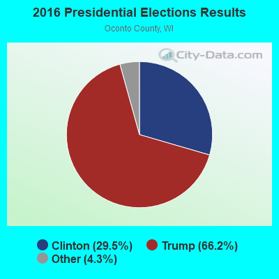
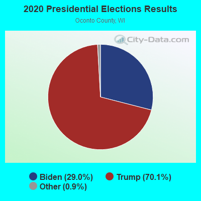
Graphs represent county-level data. Detailed 2008 Election Results
Religion statistics for How, WI (based on Oconto County data)
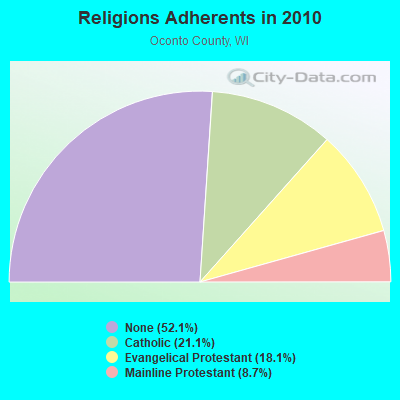
| Religion | Adherents | Congregations |
|---|---|---|
| Catholic | 7,931 | 8 |
| Evangelical Protestant | 6,833 | 29 |
| Mainline Protestant | 3,271 | 11 |
| Other | 1 | 2 |
| None | 19,624 | - |
Food Environment Statistics:
| Oconto County: | 1.60 / 10,000 pop. |
| Wisconsin: | 1.86 / 10,000 pop. |
| This county: | 5.61 / 10,000 pop. |
| Wisconsin: | 4.12 / 10,000 pop. |
| Oconto County: | 10.95 / 10,000 pop. |
| State: | 8.64 / 10,000 pop. |
| Oconto County: | 8.2% |
| State: | 7.6% |
| Here: | 28.1% |
| Wisconsin: | 27.5% |
| Here: | 19.3% |
| Wisconsin: | 13.0% |
Strongest AM radio stations in How:
- WSPT (1010 AM; 50 kW; STEVENS POINT, WI)
- WNAM (1280 AM; 50 kW; NEENAH-MENASHA, WI; Owner: CUMULUS LICENSING CORP.)
- WSAU (550 AM; 20 kW; WAUSAU, WI; Owner: WRIG, INC.)
- WHBY (1150 AM; 25 kW; KIMBERLY, WI; Owner: WOODWARD COMMUNICATIONS, INC.)
- WTAQ (1360 AM; 10 kW; GREEN BAY, WI; Owner: MIDWEST COMMUNICATIONS, INC.)
- WTCH (960 AM; 1 kW; SHAWANO, WI; Owner: RESULTS BROADCASTING OF SHAWANO, INC.)
- WTCM (580 AM; 35 kW; TRAVERSE CITY, MI; Owner: WTCM RADIO, INC.)
- WTMJ (620 AM; 50 kW; MILWAUKEE, WI; Owner: JOURNAL BROADCAST CORPORATION)
- WFCL (1380 AM; 4 kW; CLINTONVILLE, WI; Owner: RESULTS BROADCASTING CORP.)
- WLDR (1210 AM; daytime; 50 kW; KINGSLEY, MI; Owner: FORT BEND BROADCASTING COMPANY)
- WDUX (800 AM; 5 kW; WAUPACA, WI; Owner: LAIRD BROADCASTING COMPANY, INC.)
- WNFL (1440 AM; 5 kW; GREEN BAY, WI; Owner: MIDWEST COMMUNICATIONS, INC.)
- WRIG (1390 AM; 10 kW; SCHOFIELD, WI; Owner: WRIG, INC.)
Strongest FM radio stations in How:
- WRVM (102.7 FM; SURING, WI; Owner: WRVM, INC.)
- WOWN (99.3 FM; SHAWANO, WI; Owner: RESULTS BROADCASTING OF SHAWANO, INC.)
- WIXX (101.1 FM; GREEN BAY, WI; Owner: MIDWEST COMMUNICATIONS, INC.)
- WRLO-FM (105.3 FM; ANTIGO, WI; Owner: NEWRADIO GROUP, LLC)
- WQLH (98.5 FM; GREEN BAY, WI; Owner: CUMULUS LICENSING CORP.)
- WSFQ (96.3 FM; PESHTIGO, WI; Owner: BADGER COMMUNICATIONS, L.L.C.)
TV broadcast stations around How:
- WIWB (Channel 14; SURING, WI; Owner: ACME TV LICENSES OF WISCONSIN, LLC)
- WBAY-TV (Channel 2; GREEN BAY, WI; Owner: YOUNG BROADCASTING OF GREEN BAY, INC.)
- WYOW (Channel 34; EAGLE RIVER, WI; Owner: WAOW-WYOW TELEVISION, INC.)
- WPNE (Channel 38; GREEN BAY, WI; Owner: WISCONSIN EDUCATIONAL COMMUNICATIONS BOARD)
- National Bridge Inventory (NBI) Statistics
- 7Number of bridges
- 52ft / 16.2mTotal length
- $140,000Total costs
- 6,047Total average daily traffic
- 282Total average daily truck traffic
- 7,291Total future (year 2037) average daily traffic

- 55.0%Bottled, tank, or LP gas
- 17.5%Wood
- 15.8%Fuel oil, kerosene, etc.
- 9.4%Electricity
- 1.2%Other fuel
- 1.2%No fuel used

- 63.2%Bottled, tank, or LP gas
- 26.3%Wood
- 5.3%Utility gas
- 5.3%Fuel oil, kerosene, etc.
How compared to Wisconsin state average:
- Unemployed percentage below state average.
- Black race population percentage significantly below state average.
- Hispanic race population percentage below state average.
- Median age above state average.
- Foreign-born population percentage significantly below state average.
- Renting percentage significantly below state average.
- Length of stay since moving in significantly above state average.
- Number of rooms per house significantly below state average.
- House age significantly below state average.
- Number of college students below state average.
- Percentage of population with a bachelor's degree or higher significantly below state average.
State forum archive: