Granville, Massachusetts
Submit your own pictures of this town and show them to the world
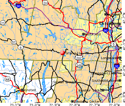
- OSM Map
- General Map
- Google Map
- MSN Map
Population change since 2000: +3.0%
 |
| Males: 796 | |
| Females: 770 |
| Median resident age: | 45.4 years |
| Massachusetts median age: | 39.2 years |
Zip codes: 01034.
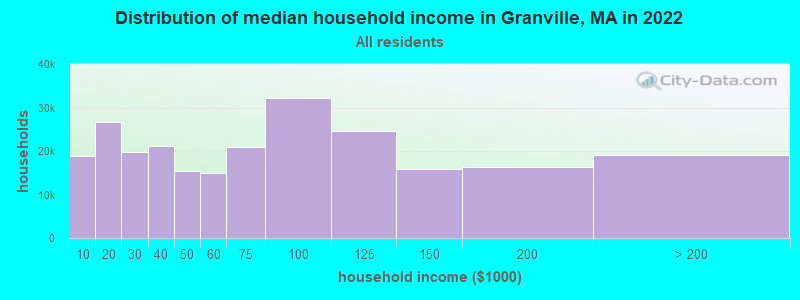
| Granville: | $85,461 |
| MA: | $94,488 |
Estimated per capita income in 2022: $39,158 (it was $22,315 in 2000)
Granville town income, earnings, and wages data
Estimated median house or condo value in 2022: $364,224 (it was $146,800 in 2000)
| Granville: | $364,224 |
| MA: | $534,700 |
Mean prices in 2022: all housing units: $315,253; detached houses: $334,901; townhouses or other attached units: $238,289; in 2-unit structures: $223,248; in 3-to-4-unit structures: $195,645; in 5-or-more-unit structures: $166,405; mobile homes: $156,908
Detailed information about poverty and poor residents in Granville, MA


Compare current foreclosures near Granville, MA:
| Photo | Address | Area | Beds / Baths | Price | Details |
|---|---|---|---|---|---|

|
#1
Main Rd
Granville, MA 01034
|
2,809 sq. feet
|
3 baths 5 beds |
show details | |

|
#2
Owls Nest Ln
Granville, MA 01034
|
- sq. feet
|
- baths - beds |
show details | |

|
#3
Reagan Rd
Granville, MA 01034
|
- sq. feet
|
- baths - beds |
show details | |

|
#4
Sanford Ave
Enfield, CT 06082
|
21 sq. feet
|
1 baths 4 beds |
$225,000
|
show details |

|
#5
Walnut Street
Springfield, MA 01105
|
2,850 sq. feet
|
2 baths 6 beds |
$99,900
|
show details |

|
#6
W Franklin St
Holyoke, MA 01040
|
1,558 sq. feet
|
1 baths 2 beds |
$234,900
|
show details |

|
#7
Cold Spring Rd
Southampton, MA 01073
|
2,736 sq. feet
|
1 baths 3 beds |
$284,900
|
show details |

|
#8
Newman St
Springfield, MA 01105
|
1,676 sq. feet
|
2 baths 3 beds |
$45,900
|
show details |

|
#9
Lancashire Rd
Springfield, MA 01104
|
1,702 sq. feet
|
3 baths 3 beds |
show details | |

|
#10
Gillette Ct # D
Simsbury, CT 06070
|
1,040 sq. feet
|
2 baths 2 beds |
show details |
| Photo | Address | Area | Beds / Baths | Price | Details |
|---|---|---|---|---|---|

|
#11
Boston Neck Rd
Suffield, CT 06078
|
2,864 sq. feet
|
4 baths 4 beds |
show details | |

|
#12
Orchard St
Winsted, CT 06098
|
1,200 sq. feet
|
2 baths 3 beds |
show details | |

|
#13
Garrett Rd
Canton, CT 06019
|
5,447 sq. feet
|
7 baths 5 beds |
show details | |

|
#14
Dunn Rd
Longmeadow, MA 01106
|
2,400 sq. feet
|
3 baths 3 beds |
show details | |

|
#15
E School St
West Springfield, MA 01089
|
1,905 sq. feet
|
2 baths 4 beds |
show details | |

|
#16
Shore Dr
Winsted, CT 06098
|
1,540 sq. feet
|
2 baths 3 beds |
show details | |

|
#17
Quorn Hunt Rd
West Simsbury, CT 06092
|
2,362 sq. feet
|
3 baths 4 beds |
show details | |

|
#18
Duncaster Rd
Bloomfield, CT 06002
|
3,478 sq. feet
|
3 baths 4 beds |
show details | |

|
#19
Boyd St
Winsted, CT 06098
|
1,184 sq. feet
|
3 baths 3 beds |
show details | |

|
#20
School St
Chicopee, MA 01013
|
2,600 sq. feet
|
2 baths 4 beds |
show details |
| Photo | Address | Area | Beds / Baths | Price | Details |
|---|---|---|---|---|---|

|
#21
Main St
Agawam, MA 01001
|
1,272 sq. feet
|
2 baths 4 beds |
show details | |

|
#22
Bridge St
Winsted, CT 06098
|
2,083 sq. feet
|
3 baths 3 beds |
show details | |

|
#23
Shepherd St
Chicopee, MA 01013
|
1,141 sq. feet
|
1 baths 2 beds |
show details | |

|
#24
Ellison St
Suffield, CT 06078
|
1,632 sq. feet
|
2 baths 3 beds |
show details | |

|
#25
Raymond Cir
Agawam, MA 01001
|
1,048 sq. feet
|
1 baths 3 beds |
show details | |

|
#26
Whiting St
Winsted, CT 06098
|
1,608 sq. feet
|
3 baths 3 beds |
show details | |

|
#27
Seymour Rd Unit 4b
East Granby, CT 06026
|
818 sq. feet
|
2 baths 1 beds |
show details | |

|
#28
Anthony St
Agawam, MA 01001
|
1,448 sq. feet
|
2 baths 3 beds |
show details | |

|
#29
Gilbert Ave
Winsted, CT 06098
|
1,544 sq. feet
|
2 baths 4 beds |
show details | |

|
#30
Holabird Ave
Winsted, CT 06098
|
976 sq. feet
|
2 baths 3 beds |
show details |
| Photo | Address | Area | Beds / Baths | Price | Details |
|---|---|---|---|---|---|

|
#31
Benton St
Winsted, CT 06098
|
1,109 sq. feet
|
2 baths 2 beds |
show details | |

|
#32
Hearthstone Dr
Barkhamsted, CT 06063
|
2,071 sq. feet
|
3 baths 3 beds |
show details | |

|
#33
Worthy Ave
West Springfield, MA 01089
|
1,501 sq. feet
|
1 baths 3 beds |
show details | |

|
#34
S Main St
East Granby, CT 06026
|
1,380 sq. feet
|
3 baths 3 beds |
show details | |

|
#35
Wallens St
Winsted, CT 06098
|
3,486 sq. feet
|
3 baths 4 beds |
show details | |

|
#36
Cambridge Ct
Simsbury, CT 06070
|
2,155 sq. feet
|
4 baths 4 beds |
show details | |

|
#37
Glendale Cir
Windsor Locks, CT 06096
|
1,277 sq. feet
|
1 baths 2 beds |
show details | |

|
#38
Bigelow Ave
Enfield, CT 06082
|
3,130 sq. feet
|
2 baths 7 beds |
show details | |

|
#39
Connecticut Ave
Springfield, MA 01104
|
1,561 sq. feet
|
1 baths 3 beds |
show details | |

|
#40
Newbury St
Springfield, MA 01104
|
1,265 sq. feet
|
1 baths 2 beds |
show details |
| Photo | Address | Area | Beds / Baths | Price | Details |
|---|---|---|---|---|---|

|
#41
Dwight St
Holyoke, MA 01040
|
3,194 sq. feet
|
2 baths 4 beds |
show details | |

|
#42
Kingsley St
Springfield, MA 01104
|
1,586 sq. feet
|
2 baths 3 beds |
show details | |

|
#43
Gantley Rd
Windsor Locks, CT 06096
|
1,212 sq. feet
|
3 baths 3 beds |
show details | |

|
#44
Juniper Dr
Windsor Locks, CT 06096
|
960 sq. feet
|
3 baths 3 beds |
show details | |

|
#45
Malden St
Springfield, MA 01108
|
1,154 sq. feet
|
1 baths 2 beds |
show details | |

|
#46
E Hill Rd Apt 4d
Canton, CT 06019
|
1,116 sq. feet
|
2 baths 2 beds |
show details | |

|
#47
Marshall St
Springfield, MA 01109
|
1,298 sq. feet
|
2 baths 2 beds |
show details | |

|
#48
Pomeroy Rd
Enfield, CT 06082
|
1,008 sq. feet
|
1 baths 3 beds |
show details | |

|
#49
Chestnut St
Windsor Locks, CT 06096
|
1,462 sq. feet
|
2 baths 3 beds |
show details | |

|
Check over 1 million property listings on Foreclosure.com!
|
browse all offers | |||

- 1,50896.3%White alone
- 291.9%Hispanic
- 151.0%Two or more races
- 40.3%Black alone
- 50.3%American Indian alone
- 50.3%Asian alone
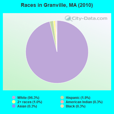
Races in Granville detailed stats: ancestries, foreign born residents, place of birth
According to our research of Massachusetts and other state lists, there was 1 registered sex offender living in Granville, Massachusetts as of June 08, 2024.
The ratio of all residents to sex offenders in Granville is 1,566 to 1.
The ratio of registered sex offenders to all residents in this city is near the state average.
Type |
2009 |
2010 |
2011 |
2012 |
2013 |
2020 |
2021 |
2022 |
|---|---|---|---|---|---|---|---|---|
| Murders (per 100,000) | 0 (0.0) | 0 (0.0) | 0 (0.0) | 0 (0.0) | 0 (0.0) | 0 (0.0) | 0 (0.0) | 0 (0.0) |
| Rapes (per 100,000) | 0 (0.0) | 0 (0.0) | 0 (0.0) | 0 (0.0) | 0 (0.0) | 0 (0.0) | 0 (0.0) | 1 (65.0) |
| Robberies (per 100,000) | 0 (0.0) | 0 (0.0) | 0 (0.0) | 0 (0.0) | 0 (0.0) | 0 (0.0) | 0 (0.0) | 0 (0.0) |
| Assaults (per 100,000) | 0 (0.0) | 1 (63.9) | 1 (63.5) | 0 (0.0) | 2 (123.8) | 0 (0.0) | 2 (123.0) | 1 (65.0) |
| Burglaries (per 100,000) | 2 (116.2) | 5 (319.3) | 0 (0.0) | 4 (253.0) | 4 (247.5) | 1 (62.1) | 0 (0.0) | 0 (0.0) |
| Thefts (per 100,000) | 7 (406.7) | 2 (127.7) | 0 (0.0) | 9 (569.3) | 4 (247.5) | 2 (124.2) | 0 (0.0) | 3 (195.1) |
| Auto thefts (per 100,000) | 0 (0.0) | 0 (0.0) | 0 (0.0) | 0 (0.0) | 0 (0.0) | 1 (62.1) | 0 (0.0) | 1 (65.0) |
| Arson (per 100,000) | 0 (0.0) | 0 (0.0) | 0 (0.0) | 0 (0.0) | 0 (0.0) | 0 (0.0) | 0 (0.0) | 1 (65.0) |
| City-Data.com crime index | 24.4 | 40.2 | 12.7 | 40.5 | 52.0 | 14.3 | 24.6 | 78.0 |
The City-Data.com crime index weighs serious crimes and violent crimes more heavily. Higher means more crime, U.S. average is 246.1. It adjusts for the number of visitors and daily workers commuting into cities.
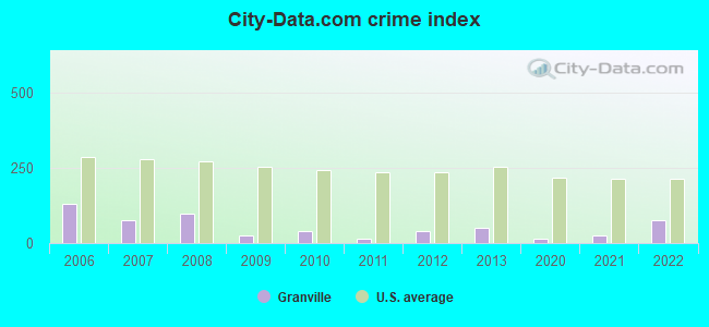
Crime rate in Granville detailed stats: murders, rapes, robberies, assaults, burglaries, thefts, arson
Full-time law enforcement employees in 2016, including police officers: 2 (1 officers - 1 male; 0 female).
| Officers per 1,000 residents here: | 0.61 |
| Massachusetts average: | 2.63 |
 Recent articles from our blog. Our writers, many of them Ph.D. graduates or candidates, create easy-to-read articles on a wide variety of topics.

 | Is it possible to escape hunters, ATVs and noise in a rural area? (278 replies) |
| Is Western Mass that bad? (104 replies) |
| Living in western mass vs. connecticut (96 replies) |
| How Much Massachusetts Households Make Per Year: Census Data (37 replies) |
| Bolton (25 replies) |
| Commute to Springfield: easier from Berkshires or NH? (22 replies) |
Latest news from Granville, MA collected exclusively by city-data.com from local newspapers, TV, and radio stations
Ancestries: Irish (21.0%), English (20.0%), Polish (15.4%), German (12.6%), French (12.2%), Italian (6.7%).
Current Local Time: EST time zone
Incorporated in 1775
Elevation: 685 feet
Land area: 42.2 square miles.
Population density: 37 people per square mile (very low).
41 residents are foreign born (1.8% Europe, 0.5% Latin America, 0.4% Asia).
| This town: | 2.7% |
| Massachusetts: | 12.2% |
| Granville town: | 1.3% ($1,964) |
| Massachusetts: | 1.3% ($2,336) |
Nearest city with pop. 50,000+: Chicopee, MA  (16.8 miles , pop. 54,653).
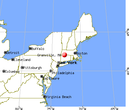
Nearest city with pop. 200,000+: Boston, MA (93.8 miles , pop. 589,141).
Nearest city with pop. 1,000,000+: Bronx, NY (99.0 miles , pop. 1,332,650).
Nearest cities:
), ), ), Latitude: 42.07 N, Longitude: 72.89 W
Area code: 413

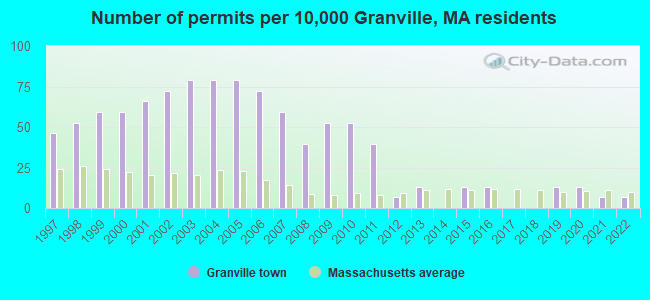
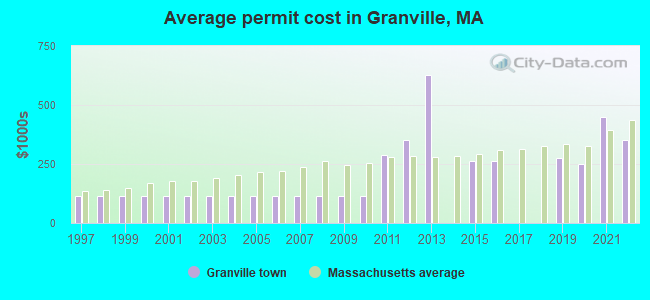
Single-family new house construction building permits:
- 2022: 1 building, cost: $350,000
- 2021: 1 building, cost: $450,000
- 2020: 2 buildings, average cost: $248,200
- 2019: 2 buildings, average cost: $275,000
- 2016: 2 buildings, average cost: $262,500
- 2015: 2 buildings, average cost: $262,500
- 2013: 2 buildings, average cost: $629,000
- 2012: 1 building, cost: $350,000
- 2011: 6 buildings, average cost: $287,500
- 2010: 8 buildings, average cost: $115,900
- 2009: 8 buildings, average cost: $115,900
- 2008: 6 buildings, average cost: $115,900
- 2007: 9 buildings, average cost: $115,900
- 2006: 11 buildings, average cost: $115,900
- 2005: 12 buildings, average cost: $115,900
- 2004: 12 buildings, average cost: $115,900
- 2003: 12 buildings, average cost: $115,900
- 2002: 11 buildings, average cost: $115,900
- 2001: 10 buildings, average cost: $115,900
- 2000: 9 buildings, average cost: $115,900
- 1999: 9 buildings, average cost: $115,900
- 1998: 8 buildings, average cost: $115,900
- 1997: 7 buildings, average cost: $115,900
| Here: | 4.0% |
| Massachusetts: | 3.5% |
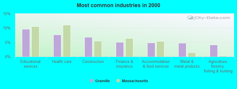
- Educational services (9.6%)
- Health care (7.6%)
- Construction (6.8%)
- Finance & insurance (5.1%)
- Accommodation & food services (4.9%)
- Metal & metal products (4.7%)
- Agriculture, forestry, fishing & hunting (4.1%)
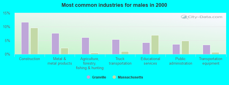
- Construction (11.7%)
- Metal & metal products (7.7%)
- Agriculture, forestry, fishing & hunting (6.1%)
- Truck transportation (5.4%)
- Educational services (4.3%)
- Public administration (3.6%)
- Transportation equipment (3.4%)
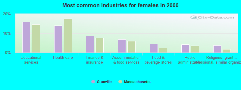
- Educational services (15.8%)
- Health care (13.9%)
- Finance & insurance (8.7%)
- Accommodation & food services (6.8%)
- Food & beverage stores (4.5%)
- Public administration (4.2%)
- Religious, grantmaking, civic, professional, similar organizations (3.7%)
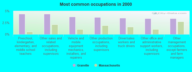
- Preschool, kindergarten, elementary, and middle school teachers (4.4%)
- Other sales and related occupations, including supervisors (4.4%)
- Vehicle and mobile equipment mechanics, installers, and repairers (3.8%)
- Other production occupations, including supervisors (3.6%)
- Driver/sales workers and truck drivers (3.5%)
- Other office and administrative support workers, including supervisors (3.4%)
- Other management occupations, except farmers and farm managers (3.4%)
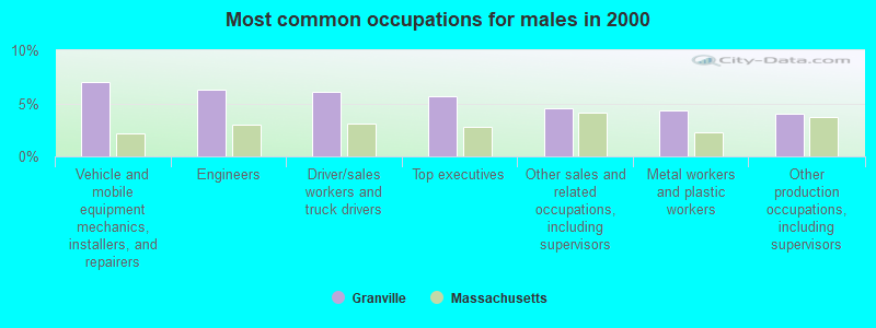
- Vehicle and mobile equipment mechanics, installers, and repairers (7.0%)
- Engineers (6.3%)
- Driver/sales workers and truck drivers (6.1%)
- Top executives (5.6%)
- Other sales and related occupations, including supervisors (4.5%)
- Metal workers and plastic workers (4.3%)
- Other production occupations, including supervisors (4.1%)
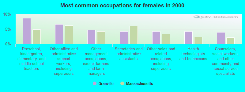
- Preschool, kindergarten, elementary, and middle school teachers (8.7%)
- Other office and administrative support workers, including supervisors (6.6%)
- Other management occupations, except farmers and farm managers (4.7%)
- Secretaries and administrative assistants (4.2%)
- Other sales and related occupations, including supervisors (4.2%)
- Health technologists and technicians (4.2%)
- Counselors, social workers, and other community and social service specialists (3.9%)
Average climate in Granville, Massachusetts
Based on data reported by over 4,000 weather stations


(lower is better)
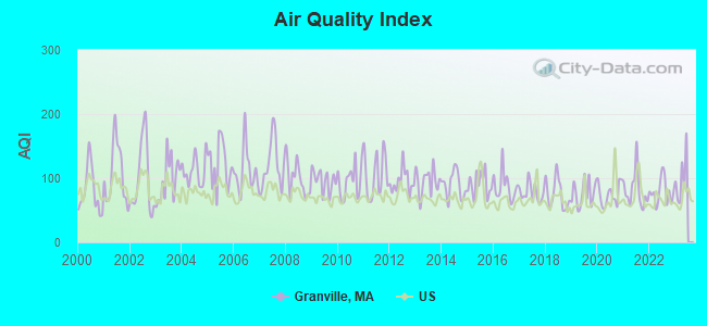
Air Quality Index (AQI) level in 2022 was 78.4. This is about average.
| City: | 78.4 |
| U.S.: | 72.6 |
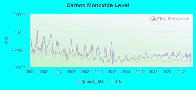
Carbon Monoxide (CO) [ppm] level in 2022 was 0.312. This is worse than average. Closest monitor was 15.2 miles away from the city center.
| City: | 0.312 |
| U.S.: | 0.251 |
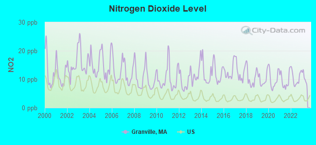
Nitrogen Dioxide (NO2) [ppb] level in 2022 was 10.5. This is significantly worse than average. Closest monitor was 10.9 miles away from the city center.
| City: | 10.5 |
| U.S.: | 5.1 |
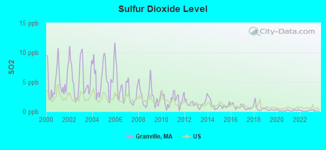
Sulfur Dioxide (SO2) [ppb] level in 2022 was 0.141. This is significantly better than average. Closest monitor was 15.0 miles away from the city center.
| City: | 0.141 |
| U.S.: | 1.515 |
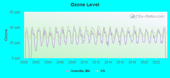
Ozone [ppb] level in 2022 was 28.2. This is about average. Closest monitor was 10.9 miles away from the city center.
| City: | 28.2 |
| U.S.: | 33.3 |
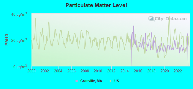
Particulate Matter (PM10) [µg/m3] level in 2022 was 13.9. This is better than average. Closest monitor was 15.2 miles away from the city center.
| City: | 13.9 |
| U.S.: | 19.2 |
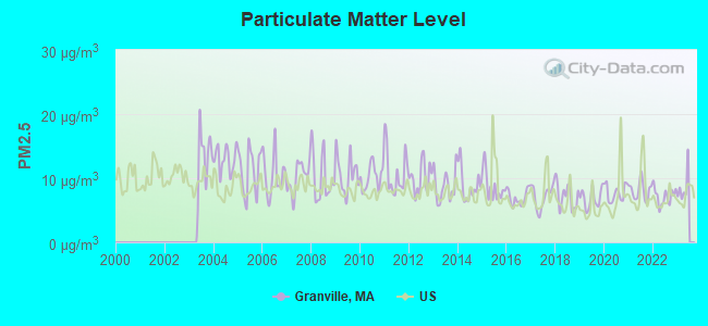
Particulate Matter (PM2.5) [µg/m3] level in 2022 was 7.16. This is about average. Closest monitor was 15.2 miles away from the city center.
| City: | 7.16 |
| U.S.: | 8.11 |
Tornado activity:
Granville-area historical tornado activity is above Massachusetts state average. It is 11% smaller than the overall U.S. average.
On 10/3/1979, a category F4 (max. wind speeds 207-260 mph) tornado 9.9 miles away from the Granville town center killed 3 people and injured 500 people and caused between $50,000,000 and $500,000,000 in damages.
On 5/29/1995, a category F4 tornado 15.9 miles away from the town center killed 3 people and injured 24 people and caused between $5,000,000 and $50,000,000 in damages.
Earthquake activity:
Granville-area historical earthquake activity is significantly above Massachusetts state average. It is 70% smaller than the overall U.S. average.On 10/7/1983 at 10:18:46, a magnitude 5.3 (5.1 MB, 5.3 LG, 5.1 ML, Class: Moderate, Intensity: VI - VII) earthquake occurred 149.3 miles away from the city center
On 4/20/2002 at 10:50:47, a magnitude 5.3 (5.3 ML, Depth: 3.0 mi) earthquake occurred 173.5 miles away from the city center
On 4/20/2002 at 10:50:47, a magnitude 5.2 (5.2 MB, 4.2 MS, 5.2 MW, 5.0 MW) earthquake occurred 172.0 miles away from Granville center
On 1/19/1982 at 00:14:42, a magnitude 4.7 (4.5 MB, 4.7 MD, 4.5 LG, Class: Light, Intensity: IV - V) earthquake occurred 118.4 miles away from the city center
On 10/16/2012 at 23:12:25, a magnitude 4.7 (4.7 ML, Depth: 10.0 mi) earthquake occurred 154.7 miles away from the city center
On 8/23/2011 at 17:51:04, a magnitude 5.8 (5.8 MW, Depth: 3.7 mi) earthquake occurred 392.9 miles away from Granville center
Magnitude types: regional Lg-wave magnitude (LG), body-wave magnitude (MB), duration magnitude (MD), local magnitude (ML), surface-wave magnitude (MS), moment magnitude (MW)
Natural disasters:
The number of natural disasters in Hampden County (22) is greater than the US average (15).Major Disasters (Presidential) Declared: 12
Emergencies Declared: 9
Causes of natural disasters: Storms: 6, Floods: 5, Hurricanes: 5, Snowstorms: 4, Winter Storms: 4, Blizzards: 2, Snows: 2, Snowfall: 1, Tornado: 1, Tropical Storm: 1, Wind: 1, Other: 1 (Note: some incidents may be assigned to more than one category).

Hospitals and medical centers near Granville:
- NOBLE VISITING NURSE (Home Health Center, about 7 miles away; WESTFIELD, MA)
- NOBLE HOSPITAL Acute Care Hospitals (about 8 miles away; WESTFIELD, MA)
- GOVERNORS CENTER (Nursing Home, about 8 miles away; WESTFIELD, MA)
- C I B: ROBERT EDWARDS COMM RES (Hospital, about 9 miles away; GRANBY, CT)
- WESTFIELD CARE AND REHABILITATION CENTER (Nursing Home, about 9 miles away; WESTFIELD, MA)
- C I B: CAROLYN JOHNS (Hospital, about 9 miles away; GRANBY, CT)
- MOUNTAIN VIEW HLTHCRE - OLD DON'T USE (Nursing Home, about 9 miles away; MONTGOMERY, MA)
Airports located in Granville:
- Morehaven Airport (MA43) (Runways: 1)
Amtrak stations near Granville:
- 16 miles: SPRINGFIELD (66 LYMAN ST.) . Services: ticket office, partially wheelchair accessible, enclosed waiting area, public restrooms, public payphones, full-service food facilities, snack bar, vending machines, ATM, paid short-term parking, paid long-term parking, call for car rental service, taxi stand, intercity bus service, public transit connection.
- 17 miles: WINDSOR LOCKS (S. MAIN ST. (RTE. 159)) . Services: public payphones, free short-term parking, free long-term parking, call for car rental service, call for taxi service, public transit connection.
- 20 miles: WINDSOR (41 CENTRAL ST.) . Services: enclosed waiting area, public restrooms, public payphones, free short-term parking, call for car rental service, call for taxi service, public transit connection.
Colleges/universities with over 2000 students nearest to Granville:
- Westfield State University (about 7 miles; Westfield, MA; Full-time enrollment: 5,548)
- Holyoke Community College (about 15 miles; Holyoke, MA; FT enrollment: 4,911)
- Bay Path College (about 16 miles; Longmeadow, MA; FT enrollment: 2,085)
- Springfield Technical Community College (about 16 miles; Springfield, MA; FT enrollment: 4,750)
- American International College (about 18 miles; Springfield, MA; FT enrollment: 2,733)
- Springfield College (about 18 miles; Springfield, MA; FT enrollment: 3,144)
- Western New England University (about 20 miles; Springfield, MA; FT enrollment: 3,477)
Public elementary/middle school in Granville:
- GRANVILLE VILLAGE SCHOOL (Students: 225, Location: 409 MAIN ROAD, Grades: KG-8)
Points of interest:
Notable locations in Granville: Mountain Orchards (A), West Parish Orchards (B), Barber Camp (C), Granville Fire Department Station 2 (D), Granville Fire Department Station 1 Headquarters (E), Granville Center Town Hall (F). Display/hide their locations on the map
Cemeteries: Granville Cemetery (1), Northeast Cemetery (2), Center Cemetery (3). Display/hide their locations on the map
Lakes, reservoirs, and swamps: Parsons Pond (A), Degano Pond (B), Black Pond (C), Granville Reservoir (D), Borden Brook Reservoir (E), Phelon Pond (F), Winchell Reservoir (G), Cooley Lake (H). Display/hide their locations on the map
Streams, rivers, and creeks: Trumble Brook (A), Tillotson Brook (B), Seymour Brook (C), Drake Brook (D), Dickinson Brook (E), Japhet Brook (F), Hollister Brook (G), Ripley Brook (H), Potash Brook (I). Display/hide their locations on the map
Birthplace of: Isaac C. Bates - Politician.
| This town: | 2.6 people |
| Massachusetts: | 2.5 people |
| This town: | 73.7% |
| Whole state: | 63.0% |
| This town: | 6.1% |
| Whole state: | 7.0% |
Likely homosexual households (counted as self-reported same-sex unmarried-partner households)
- Lesbian couples: 0.2% of all households
- Gay men: 0.5% of all households
| This town: | 3.4% |
| Whole state: | 9.3% |
| This town: | 1.3% |
| Whole state: | 4.4% |
For population 15 years and over in Granville:
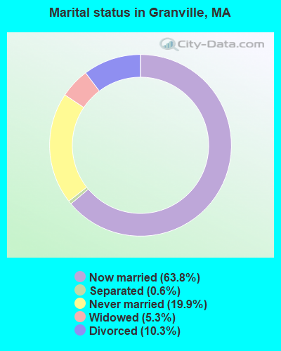
- Never married: 19.9%
- Now married: 63.8%
- Separated: 0.6%
- Widowed: 5.3%
- Divorced: 10.3%
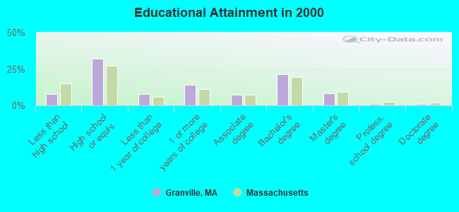
For population 25 years and over in Granville:
- High school or higher: 92.3%
- Bachelor's degree or higher: 31.3%
- Graduate or professional degree: 10.1%
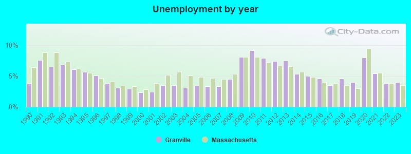
- Unemployed: 5.6%
- Mean travel time to work (commute): 29.5 minutes
| Here: | 9.8 |
| Massachusetts average: | 13.1 |
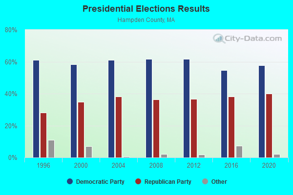
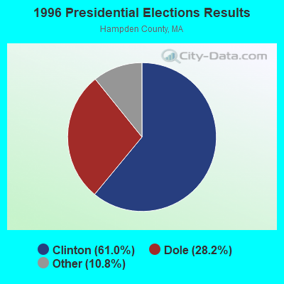
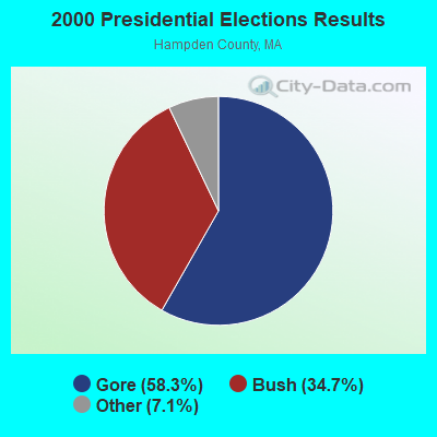
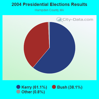
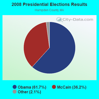
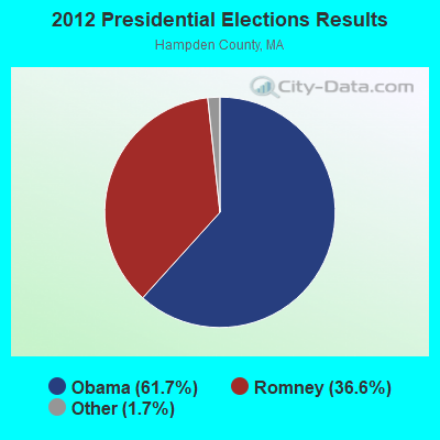
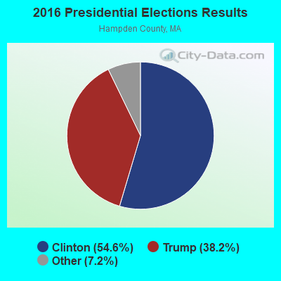
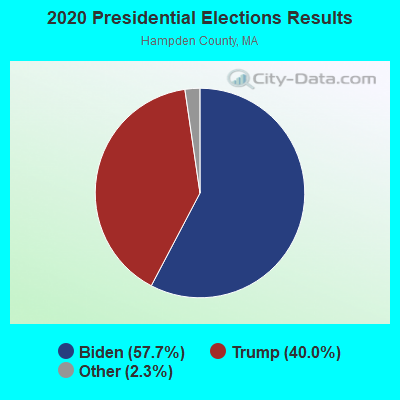
Graphs represent county-level data. Detailed 2008 Election Results
Religion statistics for Granville, MA (based on Hampden County data)
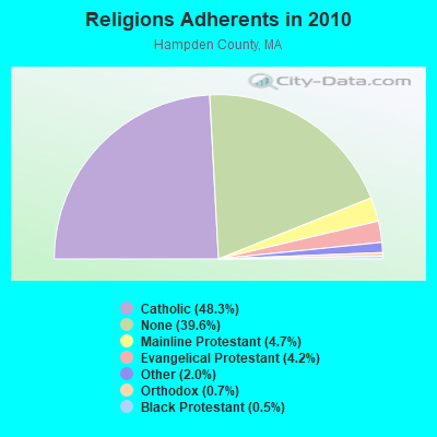
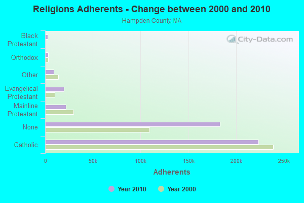
| Religion | Adherents | Congregations |
|---|---|---|
| Catholic | 223,685 | 65 |
| Mainline Protestant | 21,962 | 88 |
| Evangelical Protestant | 19,438 | 114 |
| Other | 9,140 | 31 |
| Orthodox | 3,406 | 10 |
| Black Protestant | 2,491 | 16 |
| None | 183,368 | - |
Food Environment Statistics:
| Hampden County: | 1.95 / 10,000 pop. |
| Massachusetts: | 1.98 / 10,000 pop. |
| Here: | 0.04 / 10,000 pop. |
| Massachusetts: | 0.05 / 10,000 pop. |
| Here: | 1.87 / 10,000 pop. |
| Massachusetts: | 2.22 / 10,000 pop. |
| Hampden County: | 2.43 / 10,000 pop. |
| State: | 1.77 / 10,000 pop. |
| This county: | 7.27 / 10,000 pop. |
| Massachusetts: | 8.76 / 10,000 pop. |
| Hampden County: | 9.2% |
| State: | 8.1% |
| Hampden County: | 25.9% |
| State: | 22.5% |
| Hampden County: | 16.2% |
| State: | 16.5% |
3.64% of this county's 2021 resident taxpayers lived in other counties in 2020 ($58,474 average adjusted gross income)
| Here: | 3.64% |
| Massachusetts average: | 6.35% |
0.02% of residents moved from foreign countries ($105 average AGI)
Hampden County: 0.02% Massachusetts average: 0.01%
Top counties from which taxpayers relocated into this county between 2020 and 2021:
| from Hampshire County, MA | |
| from Hartford County, CT | |
| from Worcester County, MA |
4.26% of this county's 2020 resident taxpayers moved to other counties in 2021 ($66,146 average adjusted gross income)
| Here: | 4.26% |
| Massachusetts average: | 7.18% |
0.03% of residents moved to foreign countries ($223 average AGI)
Hampden County: 0.03% Massachusetts average: 0.02%
Top counties to which taxpayers relocated from this county between 2020 and 2021:
| to Hampshire County, MA | |
| to Hartford County, CT | |
| to Worcester County, MA |
Strongest AM radio stations in Granville:
- WNNZ (640 AM; 50 kW; WESTFIELD, MA; Owner: CLEAR CHANNEL BROADCASTING LICENSES, INC.)
- WTIC (1080 AM; 50 kW; HARTFORD, CT; Owner: INFINITY RADIO OPERATIONS INC.)
- WHYN (560 AM; 5 kW; SPRINGFIELD, MA; Owner: CLEAR CHANNEL BROADCASTING LICENSES, INC.)
- WACE (730 AM; 5 kW; CHICOPEE, MA; Owner: CARTER BROADCASTING CORP.)
- WCRN (830 AM; 50 kW; WORCESTER, MA; Owner: CARTER BROADCASTING CORPORATION)
- WSPR (1270 AM; 5 kW; SPRINGFIELD, MA; Owner: ANTONIO F. AND HELENA R. GOIS, TENANTS BY THE ENTIRETY)
- WVNE (760 AM; daytime; 25 kW; LEICESTER, MA; Owner: BLOUNT MASSCOM, INC.)
- WDZK (1550 AM; 5 kW; BLOOMFIELD, CT; Owner: ABC, INC.)
- WALE (990 AM; 50 kW; GREENVILLE, RI; Owner: NORTH AMERICAN BROADCASTING CO., INC.)
- WGY (810 AM; 50 kW; SCHENECTADY, NY; Owner: CLEAR CHANNEL BROADCASTING LICENSES, INC.)
- WDRC (1360 AM; 5 kW; HARTFORD, CT; Owner: BUCKLEY BROADCASTING CORPORATION)
- WRKO (680 AM; 50 kW; BOSTON, MA; Owner: ENTERCOM BOSTON LICENSE, LLC)
- WLAT (910 AM; 5 kW; NEW BRITAIN, CT; Owner: MEGA COMMUNICATIONS OF NEW BRITAIN LICENSEE, LLC)
Strongest FM radio stations in Granville:
- WAQY (102.1 FM; SPRINGFIELD, MA; Owner: SAGA COMMUNICATIONS OF NEW ENGLAND, LLC)
- WPKX (97.9 FM; ENFIELD, CT; Owner: CAPSTAR TX LIMITED PARTNERSHIP)
- WHYN-FM (93.1 FM; SPRINGFIELD, MA; Owner: CLEAR CHANNEL BROADCASTING LICENSES, INC.)
- WRNX (100.9 FM; AMHERST, MA; Owner: WESTERN MASSACHUSETTS RADIO COMPANY)
- WRCH (100.5 FM; NEW BRITAIN, CT; Owner: INFINITY RADIO OPERATIONS INC.)
- WTIC-FM (96.5 FM; HARTFORD, CT; Owner: INFINITY RADIO OPERATIONS INC.)
- WAMC-FM (90.3 FM; ALBANY, NY; Owner: WAMC)
- WCCC-FM (106.9 FM; HARTFORD, CT; Owner: MARLIN BROADCASTING, LLC)
- WWUH (91.3 FM; WEST HARTFORD, CT; Owner: UNIVERSITY OF HARTFORD)
- WFCR (88.5 FM; AMHERST, MA; Owner: UNIVERSITY OF MASSACHUSETTS)
- WAMQ (105.1 FM; GREAT BARRINGTON, MA; Owner: WAMC)
- WJMJ (88.9 FM; HARTFORD, CT; Owner: ST. THOMAS SEMINARY)
- WHVP (91.1 FM; HUDSON, NY; Owner: SOUND OF LIFE, INC.)
- WWYZ (92.5 FM; WATERBURY, CT; Owner: CAPSTAR TX LIMITED PARTNERSHIP)
- WKSS (95.7 FM; HARTFORD-MERIDEN, CT; Owner: CAPSTAR TX LIMITED PARTNERSHIP)
- WZMX (93.7 FM; HARTFORD, CT; Owner: INFINITY RADIO OPERATIONS INC.)
- WHCN (105.9 FM; HARTFORD, CT; Owner: CAPSTAR TX LIMITED PARTNERSHIP)
- WAMH (89.3 FM; AMHERST, MA; Owner: TRUSTEES OF AMHERST COLLEGE)
- WMRQ (104.1 FM; WATERBURY, CT; Owner: CAPSTAR TX LIMITED PARTNERSHIP)
- WPKT (90.5 FM; MERIDEN, CT; Owner: CONNECTICUT PUBLIC BROADCASTING, INC)
TV broadcast stations around Granville:
- WWLP (Channel 22; SPRINGFIELD, MA; Owner: WWLP BROADCASTING, LLC)
- WTIC-TV (Channel 61; HARTFORD, CT; Owner: TRIBUNE TELEVISION COMPANY)
- W11BJ (Channel 11; HARTFORD, CT; Owner: COMMUNICATIONS SITE MANAGEMENT LLC)
- WUVN (Channel 18; HARTFORD, CT; Owner: ENTRAVISION HOLDINGS, LLC)
- WTXX (Channel 20; WATERBURY, CT; Owner: WTXX INC.)
- WVIT (Channel 30; NEW BRITAIN, CT; Owner: OUTLET BROADCASTING, INC)
- WEDH (Channel 24; HARTFORD, CT; Owner: CONNECTICUT PUBLIC BROADCASTING, INC.)
- W67DF (Channel 67; SPRINGFIELD, MA; Owner: TRINITY BROADCASTING NETWORK)
- WFSB (Channel 3; HARTFORD, CT; Owner: MEREDITH CORPORATION)
- WYDN (Channel 48; WORCESTER, MA; Owner: EDUCATIONAL PUBLIC TV CORPORATION)
- WDMR-LP (Channel 65; SPRINGFIELD, MA; Owner: ZGS HARTFORD, INC.)
- WHCT-LP (Channel 38; HARTFORD, CT; Owner: VENTURE TECHNOLOGIES GROUP, LLC)
- WHTX-LP (Channel 10; HARTFORD, CT; Owner: ENTRAVISION HOLDINGS, LLC)
- W12CL (Channel 12; GRANBY, CT; Owner: SALVATORE MINNITI)
- WRDM-LP (Channel 13; HARTFORD, CT; Owner: ZGS HARTFORD, INC.)
- WMLD-LP (Channel 6; HARTFORD, CT; Owner: HARVARD BROADCASTING, INC.)
- WGBY-TV (Channel 57; SPRINGFIELD, MA; Owner: WGBH EDUCATIONAL FOUNDATION)
- WGGB-TV (Channel 40; SPRINGFIELD, MA; Owner: WGGB LICENSEE, LLC)
- Granville, Massachusetts
- Fatal accident count13
- Vehicles involved in fatal accidents15
- Fatal accidents involving drunk persons:6
- Fatalities14
- Persons involved in fatal accidents21
- Pedestrians involved in fatal accidents0
- Massachusetts average
- Fatal accident count6003
- Vehicles involved in fatal accidents8543
- Fatal accidents involving drunk persons1981
- Fatalities6425
- Persons involved in fatal accidents13478
- Pedestrians involved in fatal accidents793
- National Bridge Inventory (NBI) Statistics
- 8Number of bridges
- 30ft / 8.9mTotal length
- $6,023,000Total costs
- 10,291Total average daily traffic
- 443Total average daily truck traffic
- 9,759Total future (year 2031) average daily traffic
FCC Registered Antenna Towers:
17 (See the full list of FCC Registered Antenna Towers in Granville)FCC Registered Broadcast Land Mobile Towers:
5- On Birch Hill Approx 1200 Ne Of Blandford Rd (Lat: 42.094722 Lon: -72.893056), Type: Tower, Structure height: 100.6 m, Overall height: 103 m, Call Sign: KCW411,
Assigned Frequencies: 159.090 MHz, Grant Date: 03/27/2024, Expiration Date: 05/10/2034, Registrant: City Of Westfield, 179 Apremont Way, Westfield, MA 01085, Phone: (413) 572-6565, Email:
- Lat: 42.102306 Lon: -72.892056, Call Sign: WPNR812,
Assigned Frequencies: 461.312 MHz, 462.312 MHz, 463.312 MHz, 464.812 MHz, 466.812 MHz, Grant Date: 05/01/2014, Expiration Date: 05/19/2024, Certifier: Philip Morin, Registrant: Pinnacle Wireless, 317 Meadow St Unit 2, Chicopee, MA 01013, Phone: (413) 314-2500, Email:
- 2.5 Mi Nw (Lat: 42.094806 Lon: -72.892889), Call Sign: WNBJ784, Licensee ID: L00050824,
Assigned Frequencies: 462.475 MHz, 462.475 MHz, Grant Date: 01/24/2001, Expiration Date: 04/16/2011, Cancellation Date: 04/17/2007, Registrant: Sprint Communications Company, LP, 2001 Edmund Halley Drive, Reston, VA 20191, Phone: (703) 433-4000, Fax: (703) 433-4035
- Electric Power Sta Gorge & Wildcat Rds (Lat: 42.117028 Lon: -72.864278), Call Sign: KCE988, Licensee ID: L00007153,
Assigned Frequencies: 47.9800 MHz, Grant Date: 10/09/1997, Expiration Date: 10/28/2002, Cancellation Date: 07/12/2002, Registrant: Northeast Utilities Service Company, Ob 270, Hartford, CT 06141-0270, Phone: (203) 665-6745
- Cobble Mtn. Sta., Electric Power Sta Gorge & Wildcat Rds (Lat: 42.117028 Lon: -72.864278), Type: Pole, Structure height: 14 m, Overall height: 15 m, Call Sign: WPZA438,
Assigned Frequencies: 37.6000 MHz, Grant Date: 12/12/2003, Expiration Date: 12/12/2013, Cancellation Date: 02/15/2014, Certifier: George A Romano Jr., Registrant: Springfield Water And Sewer Commission, Springfield, MA 01101, Phone: (413) 787-6256, Fax: (413) 787-6061, Email:
FCC Registered Microwave Towers:
10 (See the full list of FCC Registered Microwave Towers in this town)FCC Registered Amateur Radio Licenses:
9 (See the full list of FCC Registered Amateur Radio Licenses in Granville)FAA Registered Aircraft:
1- Aircraft: BEECH C23 (Category: Land, Seats: 4, Weight: Up to 12,499 Pounds, Speed: 116 mph), Engine: LYCOMING O&VO-360 SER (180 HP) (Reciprocating)
N-Number: 2076A, N2076A, N-2076A, Serial Number: M-2054, Year manufactured: 1978, Airworthiness Date: 06/13/1978, Certificate Issue Date: 09/28/2012
Registrant (Individual): John T Audet, 360 Water St, Granville, MA 01034
2002 - 2018 National Fire Incident Reporting System (NFIRS) incidents
- Fire incident types reported to NFIRS in Granville, MA
- 9555.6%Structure Fires
- 3621.1%Outside Fires
- 2615.2%Other
- 148.2%Mobile Property/Vehicle Fires
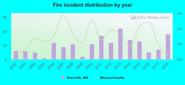 Based on the data from the years 2002 - 2018 the average number of fire incidents per year is 10. The highest number of fires - 22 took place in 2013, and the least - 1 in 2005. The data has an increasing trend.
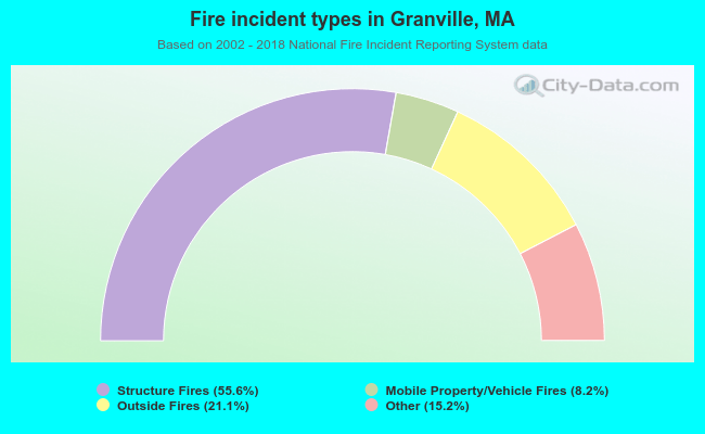 When looking into fire subcategories, the most reports belonged to: Structure Fires (55.6%), and Outside Fires (21.1%).
- 81.3%Fuel oil, kerosene, etc.
- 12.3%Wood
- 3.1%Electricity
- 2.5%Bottled, tank, or LP gas
- 0.4%Utility gas
- 0.4%Coal or coke
- 79.7%Fuel oil, kerosene, etc.
- 8.7%Wood
- 5.8%Electricity
- 2.9%Bottled, tank, or LP gas
- 2.9%Other fuel
Granville compared to Massachusetts state average:
- Unemployed percentage below state average.
- Black race population percentage significantly below state average.
- Hispanic race population percentage significantly below state average.
- Median age above state average.
- Foreign-born population percentage significantly below state average.
- Renting percentage significantly below state average.
- Length of stay since moving in significantly above state average.
- Number of rooms per house significantly below state average.
- House age significantly below state average.

|
|
Total of 14 patent applications in 2008-2024.