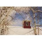
Grafton, New Hampshire
Submit your own pictures of this town and show them to the world
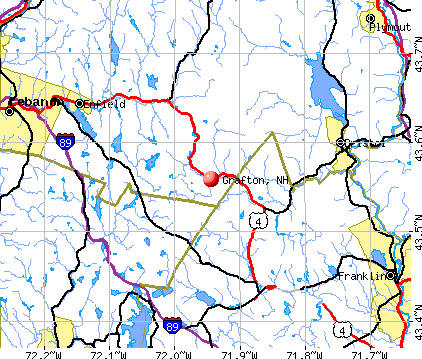
- OSM Map
- General Map
- Google Map
- MSN Map
Population change since 2000: +17.8%
 |
| Males: 698 | |
| Females: 642 |
| Median resident age: | 45.6 years |
| New Hampshire median age: | 43.9 years |
Zip codes: 03240.
| Grafton: | $75,577 |
| NH: | $89,992 |
Estimated per capita income in 2022: $38,531 (it was $16,944 in 2000)
Grafton town income, earnings, and wages data
Estimated median house or condo value in 2022: $249,625 (it was $78,100 in 2000)
| Grafton: | $249,625 |
| NH: | $384,700 |
Mean prices in 2022: all housing units: $486,096; detached houses: $533,852; townhouses or other attached units: $375,744; in 2-unit structures: $230,260; in 3-to-4-unit structures: $242,363; in 5-or-more-unit structures: $588,257; mobile homes: $127,035
Detailed information about poverty and poor residents in Grafton, NH


- 1,28996.2%White alone
- 211.6%Two or more races
- 201.5%Hispanic
- 50.4%Asian alone
- 30.2%American Indian alone
- 20.1%Black alone

Races in Grafton detailed stats: ancestries, foreign born residents, place of birth
According to our research of New Hampshire and other state lists, there were 5 registered sex offenders living in Grafton, New Hampshire as of June 06, 2024.
The ratio of all residents to sex offenders in Grafton is 268 to 1.
Type |
2019 |
2020 |
2021 |
2022 |
|---|---|---|---|---|
| Murders (per 100,000) | 0 (0.0) | 0 (0.0) | 0 (0.0) | 0 (0.0) |
| Rapes (per 100,000) | 0 (0.0) | 0 (0.0) | 0 (0.0) | 0 (0.0) |
| Robberies (per 100,000) | 0 (0.0) | 0 (0.0) | 0 (0.0) | 0 (0.0) |
| Assaults (per 100,000) | 0 (0.0) | 1 (75.3) | 1 (74.8) | 0 (0.0) |
| Burglaries (per 100,000) | 1 (74.9) | 1 (75.3) | 2 (149.6) | 1 (70.7) |
| Thefts (per 100,000) | 2 (149.7) | 1 (75.3) | 2 (149.6) | 1 (70.7) |
| Auto thefts (per 100,000) | 2 (149.7) | 1 (75.3) | 1 (74.8) | 0 (0.0) |
| Arson (per 100,000) | 0 (0.0) | 0 (0.0) | 0 (0.0) | 0 (0.0) |
| City-Data.com crime index | 23.2 | 29.4 | 37.4 | 7.8 |
The City-Data.com crime index weighs serious crimes and violent crimes more heavily. Higher means more crime, U.S. average is 246.1. It adjusts for the number of visitors and daily workers commuting into cities.

Crime rate in Grafton detailed stats: murders, rapes, robberies, assaults, burglaries, thefts, arson
Full-time law enforcement employees in 2021, including police officers: 1 (1 officers - 1 male; 0 female).
| Officers per 1,000 residents here: | 0.75 |
| New Hampshire average: | 2.14 |
 Recent articles from our blog. Our writers, many of them Ph.D. graduates or candidates, create easy-to-read articles on a wide variety of topics.

 | Grafton County Nurshing Home considering sending residents away due to current and anticipated worker shortage (5 replies) |
| where is it easiest to live off grid Grafton County? (10 replies) |
| Zhukovskyy finally going to trial (38 replies) |
| Nice towns in NH (38 replies) |
| NH Sale & Income tax offset with property taxes? (150 replies) |
| Covid-19 New Hampshire (56 replies) |
Latest news from Grafton, NH collected exclusively by city-data.com from local newspapers, TV, and radio stations
Ancestries: English (23.4%), French (20.1%), Irish (16.0%), German (9.8%), Scottish (7.1%), Scotch-Irish (6.3%).
Current Local Time: EST time zone
Incorporated in 1778
Elevation: 841 feet
Land area: 41.8 square miles.
Population density: 32 people per square mile (very low).
29 residents are foreign born (1.1% Europe, 0.9% North America, 0.4% Oceania).
| This town: | 2.5% |
| New Hampshire: | 4.4% |
| Grafton town: | 2.2% ($1,701) |
| New Hampshire: | 2.3% ($2,946) |
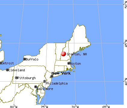
Nearest city with pop. 50,000+: Manchester, NH  (48.4 miles , pop. 107,006).
Nearest city with pop. 200,000+: Boston, MA (97.5 miles , pop. 589,141).
Nearest city with pop. 1,000,000+: Bronx, NY (212.2 miles , pop. 1,332,650).
Nearest cities:
), ), ), ), Latitude: 43.57 N, Longitude: 71.97 W
Area code commonly used in this area: 603


Single-family new house construction building permits:
- 2022: 10 buildings, average cost: $259,200
- 2021: 9 buildings, average cost: $259,200
- 2020: 7 buildings, average cost: $248,200
- 2019: 1 building, cost: $40,000
- 2018: 2 buildings, average cost: $249,800
- 2017: 3 buildings, average cost: $248,100
- 2016: 1 building, cost: $246,000
- 2015: 2 buildings, average cost: $226,800
- 2014: 3 buildings, average cost: $116,700
- 2013: 6 buildings, average cost: $108,300
- 2012: 3 buildings, average cost: $66,700
- 2011: 1 building, cost: $150,000
- 2010: 7 buildings, average cost: $165,900
- 2007: 8 buildings, average cost: $181,200
- 2006: 69 buildings, average cost: $171,000


| Here: | 2.0% |
| New Hampshire: | 2.5% |


- Educational services (9.5%)
- Construction (9.0%)
- Health care (7.4%)
- Metal & metal products (7.4%)
- Food & beverage stores (7.3%)
- Accommodation & food services (6.2%)
- Administrative & support & waste management services (4.6%)

- Construction (15.4%)
- Metal & metal products (8.2%)
- Food & beverage stores (7.5%)
- Educational services (7.2%)
- Public administration (5.3%)
- Accommodation & food services (4.7%)
- Repair & maintenance (4.4%)

- Health care (13.1%)
- Educational services (12.0%)
- Accommodation & food services (8.0%)
- Food & beverage stores (6.9%)
- Metal & metal products (6.6%)
- Administrative & support & waste management services (5.8%)
- Miscellaneous manufacturing (4.4%)

- Building and grounds cleaning and maintenance occupations (5.7%)
- Other sales and related occupations, including supervisors (5.1%)
- Other production occupations, including supervisors (5.1%)
- Metal workers and plastic workers (5.1%)
- Retail sales workers, except cashiers (4.7%)
- Material recording, scheduling, dispatching, and distributing workers (4.6%)
- Other management occupations, except farmers and farm managers (4.4%)

- Vehicle and mobile equipment mechanics, installers, and repairers (6.0%)
- Other sales and related occupations, including supervisors (6.0%)
- Other production occupations, including supervisors (5.7%)
- Metal workers and plastic workers (5.7%)
- Retail sales workers, except cashiers (5.0%)
- Electrical equipment mechanics and other installation, maintenance, and repair workers, including supervisors (4.7%)
- Building and grounds cleaning and maintenance occupations (4.4%)

- Building and grounds cleaning and maintenance occupations (7.3%)
- Assemblers and fabricators (6.2%)
- Secretaries and administrative assistants (5.8%)
- Material recording, scheduling, dispatching, and distributing workers (5.5%)
- Registered nurses (5.1%)
- Other management occupations, except farmers and farm managers (4.7%)
- Retail sales workers, except cashiers (4.4%)
Average climate in Grafton, New Hampshire
Based on data reported by over 4,000 weather stations


(lower is better)

Air Quality Index (AQI) level in 2022 was 52.4. This is better than average.
| City: | 52.4 |
| U.S.: | 72.6 |

Sulfur Dioxide (SO2) [ppb] level in 2001 was 4.62. This is significantly worse than average. Closest monitor was 18.8 miles away from the city center.
| City: | 4.62 |
| U.S.: | 1.51 |

Ozone [ppb] level in 2022 was 26.0. This is better than average. Closest monitor was 17.2 miles away from the city center.
| City: | 26.0 |
| U.S.: | 33.3 |

Particulate Matter (PM2.5) [µg/m3] level in 2022 was 5.20. This is significantly better than average. Closest monitor was 17.2 miles away from the city center.
| City: | 5.20 |
| U.S.: | 8.11 |
Tornado activity:
Grafton-area historical tornado activity is slightly below New Hampshire state average. It is 60% smaller than the overall U.S. average.
On 5/11/1973, a category F2 (max. wind speeds 113-157 mph) tornado 1.2 miles away from the Grafton town center .
On 7/9/1962, a category F2 tornado 24.6 miles away from the town center caused between $500 and $5000 in damages.
Earthquake activity:
Grafton-area historical earthquake activity is significantly above New Hampshire state average. It is 71% smaller than the overall U.S. average.On 4/20/2002 at 10:50:47, a magnitude 5.3 (5.3 ML, Depth: 3.0 mi, Class: Moderate, Intensity: VI - VII) earthquake occurred 107.5 miles away from the city center
On 10/7/1983 at 10:18:46, a magnitude 5.3 (5.1 MB, 5.3 LG, 5.1 ML) earthquake occurred 121.2 miles away from the city center
On 4/20/2002 at 10:50:47, a magnitude 5.2 (5.2 MB, 4.2 MS, 5.2 MW, 5.0 MW) earthquake occurred 107.3 miles away from Grafton center
On 1/19/1982 at 00:14:42, a magnitude 4.7 (4.5 MB, 4.7 MD, 4.5 LG, Class: Light, Intensity: IV - V) earthquake occurred 19.4 miles away from the city center
On 10/16/2012 at 23:12:25, a magnitude 4.7 (4.7 ML, Depth: 10.0 mi) earthquake occurred 66.1 miles away from the city center
On 6/16/1995 at 12:13:11, a magnitude 3.8 (3.8 LG, Depth: 3.1 mi, Class: Light, Intensity: II - III) earthquake occurred 49.4 miles away from Grafton center
Magnitude types: regional Lg-wave magnitude (LG), body-wave magnitude (MB), duration magnitude (MD), local magnitude (ML), surface-wave magnitude (MS), moment magnitude (MW)
Natural disasters:
The number of natural disasters in Grafton County (32) is a lot greater than the US average (15).Major Disasters (Presidential) Declared: 20
Emergencies Declared: 9
Causes of natural disasters: Floods: 16, Storms: 16, Hurricanes: 3, Snows: 3, Winter Storms: 3, Tropical Storms: 2, Blizzard: 1, Heavy Rain: 1, Ice Storm: 1, Landslide: 1, Snowfall: 1, Snowstorm: 1, Wind: 1, Other: 1 (Note: some incidents may be assigned to more than one category).

Hospitals and medical centers near Grafton:
- LAKE SUNAPEE REGION VNA (Home Health Center, about 10 miles away; NEW LONDON, NH)
- NEW LONDON HOSPITAL Critical Access Hospitals (about 12 miles away; NEW LONDON, NH)
- NEW LONDON HOSPITAL ASSOCIATION INC (Hospital, about 12 miles away; NEW LONDON, NH)
- WILLIAM CLOUGH ECU (Nursing Home, about 12 miles away; NEW LONDON, NH)
- NEWFOUND AREA NURSING ASSN (Home Health Center, about 12 miles away; BRISTOL, NH)
- FRESENIUS MEDICAL CARE OF LEBANON (Dialysis Facility, about 15 miles away; LEBANON, NH)
Heliports located in Grafton:
Amtrak station near Grafton:
Colleges/universities with over 2000 students nearest to Grafton:
- Dartmouth College (about 19 miles; Hanover, NH; Full-time enrollment: 6,030)
- Plymouth State University (about 20 miles; Plymouth, NH; FT enrollment: 4,838)
- NHTI-Concord's Community College (about 33 miles; Concord, NH; FT enrollment: 2,865)
- Southern New Hampshire University (about 46 miles; Manchester, NH; FT enrollment: 16,552)
- Saint Anselm College (about 47 miles; Manchester, NH; FT enrollment: 2,059)
- Keene State College (about 48 miles; Keene, NH; FT enrollment: 5,098)
- Mount Washington College (about 49 miles; Manchester, NH; FT enrollment: 2,187)
Points of interest:
Notable locations in Grafton: Cardigan Station (A), Golden Valley Ranch (B), Grafton Volunteer Fire Department (C), Grafton Ambulance Association (D). Display/hide their locations on the map
Church in Grafton: Unification Church (A). Display/hide its location on the map
Cemetery: Prescott Hill Cemetery (1). Display/hide its location on the map
Lakes and reservoirs: Hale Pond (A), Halfmoon Pond (B), Mud Pond (C), Tewksbury Pond (D), Three Thousand Acre Pond (E), Whitney Pond (F), Grafton Pond (G), Grants Pond (H). Display/hide their locations on the map
Streams, rivers, and creeks: Smith Brook (A), Sanders Brook (B), Mill Brook (C), Manfeltree Brook (D), Hoyt Brook (E), Halfmoon Pond Brook (F), Brown Brook (G). Display/hide their locations on the map
| This town: | 2.4 people |
| New Hampshire: | 2.5 people |
| This town: | 66.0% |
| Whole state: | 66.3% |
| This town: | 9.8% |
| Whole state: | 8.3% |
Likely homosexual households (counted as self-reported same-sex unmarried-partner households)
- Lesbian couples: 0.2% of all households
- Gay men: 0.7% of all households
| This town: | 7.9% |
| Whole state: | 6.5% |
| This town: | 1.5% |
| Whole state: | 2.8% |
For population 15 years and over in Grafton:

- Never married: 23.6%
- Now married: 60.2%
- Separated: 1.2%
- Widowed: 5.4%
- Divorced: 9.5%
For population 25 years and over in Grafton:
- High school or higher: 81.8%
- Bachelor's degree or higher: 21.9%
- Graduate or professional degree: 8.0%
- Unemployed: 5.0%
- Mean travel time to work (commute): 36.2 minutes


| Here: | 11.4 |
| New Hampshire average: | 10.9 |


Graphs represent county-level data. Detailed 2008 Election Results
Religion statistics for Grafton, NH (based on Grafton County data)


| Religion | Adherents | Congregations |
|---|---|---|
| Catholic | 9,503 | 12 |
| Mainline Protestant | 7,832 | 57 |
| Evangelical Protestant | 1,494 | 29 |
| Other | 1,320 | 11 |
| None | 68,969 | - |
Food Environment Statistics:
| Grafton County: | 3.87 / 10,000 pop. |
| New Hampshire: | 2.14 / 10,000 pop. |
| Here: | 0.23 / 10,000 pop. |
| State: | 0.15 / 10,000 pop. |
| Grafton County: | 1.29 / 10,000 pop. |
| New Hampshire: | 1.78 / 10,000 pop. |
| Grafton County: | 6.45 / 10,000 pop. |
| New Hampshire: | 4.02 / 10,000 pop. |
| Here: | 14.41 / 10,000 pop. |
| New Hampshire: | 9.70 / 10,000 pop. |
| Here: | 7.2% |
| New Hampshire: | 7.6% |
| Grafton County: | 22.9% |
| New Hampshire: | 24.4% |
| This county: | 15.9% |
| State: | 15.9% |
Strongest AM radio stations in Grafton:
- WNTK (1020 AM; 10 kW; NEWPORT, NH; Owner: KOOR COMMUNICATIONS, INC.)
- WPNH (1300 AM; 5 kW; PLYMOUTH, NH; Owner: NORTHEAST COMMUNICATIONS CORPORATION)
- WRKO (680 AM; 50 kW; BOSTON, MA; Owner: ENTERCOM BOSTON LICENSE, LLC)
- WCRN (830 AM; 50 kW; WORCESTER, MA; Owner: CARTER BROADCASTING CORPORATION)
- WEZS (1350 AM; 5 kW; LACONIA, NH; Owner: GARY W. HAMMOND)
- WNNZ (640 AM; 50 kW; WESTFIELD, MA; Owner: CLEAR CHANNEL BROADCASTING LICENSES, INC.)
- WEEI (850 AM; 50 kW; BOSTON, MA; Owner: ENTERCOM BOSTON LICENSE, LLC)
- WKOX (1200 AM; 50 kW; FRAMINGHAM, MA; Owner: CAPSTAR TX LIMITED PARTNERSHIP)
- WGY (810 AM; 50 kW; SCHENECTADY, NY; Owner: CLEAR CHANNEL BROADCASTING LICENSES, INC.)
- WBZ (1030 AM; 50 kW; BOSTON, MA; Owner: INFINITY BROADCASTING OPERATIONS, INC.)
- WBIX (1060 AM; 40 kW; NATICK, MA; Owner: LANGER BROADCASTING CORPORATION)
- WWZN (1510 AM; 50 kW; BOSTON, MA; Owner: ROSE CITY RADIO CORPORATION)
- WALE (990 AM; 50 kW; GREENVILLE, RI; Owner: NORTH AMERICAN BROADCASTING CO., INC.)
Strongest FM radio stations in Grafton:
- WEVH (91.3 FM; HANOVER, NH; Owner: NEW HAMPSHIRE PUBLIC RADIO INC)
- WHDQ (106.1 FM; CLAREMONT, NH; Owner: GREAT NORTHERN RADIO, L.L.C.)
- WNTK-FM (99.7 FM; NEW LONDON, NH; Owner: SHEILA E. VINIKOOR)
- WPNH-FM (100.1 FM; PLYMOUTH, NH; Owner: NORTHEAST COMMUNICATIONS CORPORATION)
- WVPR (89.5 FM; WINDSOR, VT; Owner: VERMONT PUBLIC RADIO)
- WVRR (101.7 FM; NEWPORT, NH; Owner: CAPSTAR TX LIMITED PARTNERSHIP)
- WVFM (105.7 FM; CAMPTON, NH; Owner: DEVON BROADCASTING COMPANY, INC.)
- WSCY (106.9 FM; MOULTONBOROUGH, NH; Owner: NORTHEAST COMMUNICATIONS CORPORATION)
- WJJR (98.1 FM; RUTLAND, VT; Owner: 6 JOHNSON ROAD LICENSES, INC.)
- WZRT (97.1 FM; RUTLAND, VT; Owner: CAPSTAR TX LIMITED PARTNERSHIP)
- WPKQ (103.7 FM; NORTH CONWAY, NH; Owner: CITADEL BROADCASTING COMPANY)
- WEBK (105.3 FM; KILLINGTON, VT; Owner: 6 JOHNSON ROAD LICENSES, INC.)
- WHOM (94.9 FM; MT. WASHINGTON, NH; Owner: CITADEL BROADCASTING COMPANY)
- WXXK (100.5 FM; LEBANON, NH; Owner: CAPSTAR TX LIMITED PARTNERSHIP)
- WGLV (91.7 FM; WOODSTOCK, VT; Owner: CHRISTIAN MINISTRIES INC)
- WHDQ-FM1 (106.1 FM; RUTLAND, VT; Owner: GREAT NORTHERN RADIO, L.L.C.)
- WNHI (93.3 FM; BELMONT, NH; Owner: CONCORD BROADCASTING, L.L.C.)
- WSCS (90.9 FM; NEW LONDON, NH; Owner: COLBY-SAWYER COLLEGE)
- WLKZ (104.9 FM; WOLFEBORO, NH; Owner: TELE-MEDIA COMPANY OF NEW HAMPSHIRE, L.L.C.)
- WMXR (93.9 FM; WOODSTOCK, VT; Owner: CLEAR CHANNEL BROADCASTING LICENSES, INC.)
TV broadcast stations around Grafton:
- W15BK (Channel 15; HANOVER, NH; Owner: UNIVERSITY OF NEW HAMPSHIRE)
- WVTA (Channel 41; WINDSOR, VT; Owner: VERMONT ETV, INC.)
Grafton fatal accident list:
Nov 14, 2004 07:55 AM, Sr-112, Us-118, Vehicles: 1, Persons: 1, Fatalities: 1, Drunk persons involved: 1
Aug 16, 2003 09:30 PM, Blueberry Hill Rd, Vehicles: 1, Persons: 1, Fatalities: 1, Drunk persons involved: 1
Jul 2, 1994 10:00 PM, Route 4, Vehicles: 1, Persons: 1, Fatalities: 1, Drunk persons involved: 1
Apr 1, 1992 11:00 PM, 21563, Vehicles: 1, Persons: 1, Fatalities: 1, Drunk persons involved: 1
- National Bridge Inventory (NBI) Statistics
- 16Number of bridges
- 52ft / 16.5mTotal length
- $50,272,000Total costs
- 8,433Total average daily traffic
- 532Total average daily truck traffic
- 12,471Total future (year 2042) average daily traffic

- New bridges - historical statistics
- 11920-1929
- 11930-1939
- 21940-1949
- 11970-1979
- 41980-1989
- 21990-1999
- 32000-2009
- 22010-2019

- 48.0%Fuel oil, kerosene, etc.
- 25.6%Wood
- 23.2%Bottled, tank, or LP gas
- 1.6%Electricity
- 1.0%Other fuel
- 0.5%Utility gas

- 40.3%Fuel oil, kerosene, etc.
- 25.4%Wood
- 22.4%Bottled, tank, or LP gas
- 7.5%Other fuel
- 4.5%Electricity
Grafton compared to New Hampshire state average:
- Median house value below state average.
- Unemployed percentage below state average.
- Black race population percentage significantly below state average.
- Hispanic race population percentage below state average.
- Foreign-born population percentage significantly below state average.
- Renting percentage below state average.
- Length of stay since moving in significantly above state average.
- Number of rooms per house significantly below state average.
- House age significantly below state average.

|
|
Total of 22 patent applications in 2008-2024.