Foster, Kentucky
Submit your own pictures of this place and show them to the world
- OSM Map
- General Map
- Google Map
- MSN Map

| Males: 971 | |
| Females: 955 |
| Median resident age: | 36.2 years |
| Kentucky median age: | 35.9 years |
Zip code: 41043
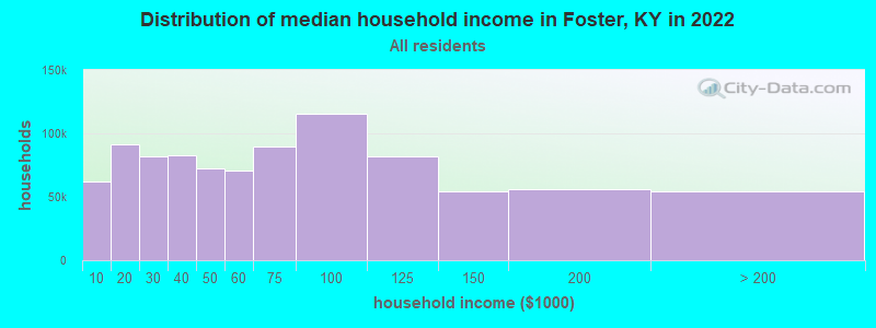
| Foster: | $57,253 |
| KY: | $59,341 |
Estimated per capita income in 2022: $30,143 (it was $16,798 in 2000)
Foster CCD income, earnings, and wages data
Estimated median house or condo value in 2022: $148,957 (it was $79,700 in 2000)
| Foster: | $148,957 |
| KY: | $196,300 |
Mean prices in 2022: all housing units: $218,619; detached houses: $254,881; townhouses or other attached units: $211,249; in 2-unit structures: $69,669; mobile homes: $94,005
Detailed information about poverty and poor residents in Foster, KY


- 1,83899.2%White alone
- 50.3%American Indian alone
- 30.2%Black alone
- 40.2%Hispanic
- 10.05%Asian alone
- 10.05%Other race alone
- 10.05%Two or more races

Races in Foster detailed stats: ancestries, foreign born residents, place of birth
According to our research of Kentucky and other state lists, there were 5 registered sex offenders living in Foster, Kentucky as of June 08, 2024.
The ratio of all residents to sex offenders in Foster is 385 to 1.
The ratio of registered sex offenders to all residents in this city is near the state average.
 Recent articles from our blog. Our writers, many of them Ph.D. graduates or candidates, create easy-to-read articles on a wide variety of topics.
Current Local Time: EST time zone
Incorporated on 01/30/1850
Land area: 52.5 square miles.
Population density: 37 people per square mile (very low).

| Foster CCD: | 0.5% ($370) |
| Kentucky: | 0.8% ($610) |
Nearest city with pop. 50,000+: Cincinnati, OH  (31.6 miles , pop. 331,285).
Nearest city with pop. 1,000,000+: Chicago, IL (282.2 miles , pop. 2,896,016).
Nearest cities:
), ), Latitude: 38.76 N, Longitude: 84.17 W

| Here: | 4.1% |
| Kentucky: | 3.8% |
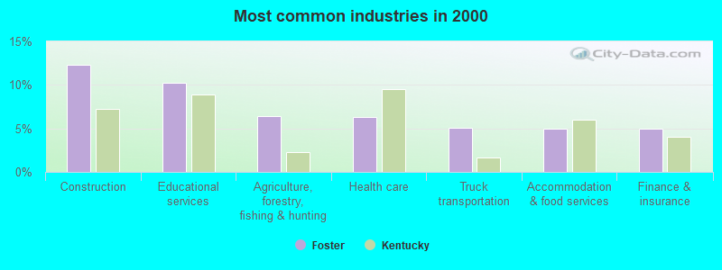
- Construction (12.3%)
- Educational services (10.2%)
- Agriculture, forestry, fishing & hunting (6.4%)
- Health care (6.3%)
- Truck transportation (5.0%)
- Accommodation & food services (4.9%)
- Finance & insurance (4.9%)
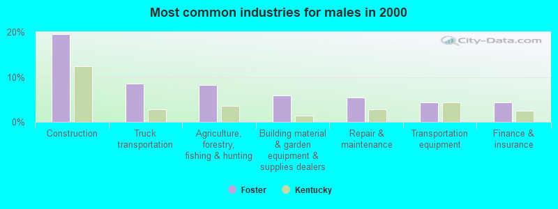
- Construction (19.5%)
- Truck transportation (8.6%)
- Agriculture, forestry, fishing & hunting (8.2%)
- Building material & garden equipment & supplies dealers (5.9%)
- Repair & maintenance (5.5%)
- Transportation equipment (4.4%)
- Finance & insurance (4.4%)
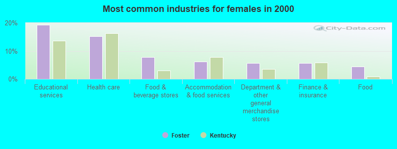
- Educational services (19.3%)
- Health care (15.2%)
- Food & beverage stores (7.7%)
- Accommodation & food services (6.2%)
- Department & other general merchandise stores (5.7%)
- Finance & insurance (5.7%)
- Food (4.5%)

- Laborers and material movers, hand (4.8%)
- Assemblers and fabricators (4.7%)
- Vehicle and mobile equipment mechanics, installers, and repairers (4.7%)
- Metal workers and plastic workers (4.6%)
- Other management occupations, except farmers and farm managers (4.4%)
- Driver/sales workers and truck drivers (4.3%)
- Preschool, kindergarten, elementary, and middle school teachers (4.3%)

- Vehicle and mobile equipment mechanics, installers, and repairers (8.0%)
- Metal workers and plastic workers (7.8%)
- Driver/sales workers and truck drivers (7.3%)
- Other production occupations, including supervisors (7.1%)
- Farmers and farm managers (6.9%)
- Construction traders workers except carpenters, electricians, painters, plumbers, and construction laborers (5.5%)
- Carpenters (5.2%)

- Preschool, kindergarten, elementary, and middle school teachers (9.2%)
- Cashiers (8.3%)
- Assemblers and fabricators (7.1%)
- Other office and administrative support workers, including supervisors (4.8%)
- Other management occupations, except farmers and farm managers (4.5%)
- Other healthcare support occupations (4.5%)
- Computer specialists (4.2%)
Average climate in Foster, Kentucky
Based on data reported by over 4,000 weather stations


(lower is better)

Air Quality Index (AQI) level in 2023 was 86.1. This is about average.
| City: | 86.1 |
| U.S.: | 72.6 |

Nitrogen Dioxide (NO2) [ppb] level in 2022 was 4.63. This is about average. Closest monitor was 10.6 miles away from the city center.
| City: | 4.63 |
| U.S.: | 5.11 |

Sulfur Dioxide (SO2) [ppb] level in 2022 was 0.686. This is significantly better than average. Closest monitor was 10.6 miles away from the city center.
| City: | 0.686 |
| U.S.: | 1.515 |

Ozone [ppb] level in 2022 was 31.7. This is about average. Closest monitor was 10.5 miles away from the city center.
| City: | 31.7 |
| U.S.: | 33.3 |

Particulate Matter (PM2.5) [µg/m3] level in 2023 was 8.77. This is about average. Closest monitor was 22.5 miles away from the city center.
| City: | 8.77 |
| U.S.: | 8.11 |
Tornado activity:
Foster-area historical tornado activity is near Kentucky state average. It is 34% greater than the overall U.S. average.
On 4/23/1968, a category F4 (max. wind speeds 207-260 mph) tornado 12.3 miles away from the Foster place center killed 6 people and injured 364 people and caused between $5,000,000 and $50,000,000 in damages.
On 4/3/1974, a category F5 (max. wind speeds 261-318 mph) tornado 40.3 miles away from the place center killed 3 people and injured 210 people.
Earthquake activity:
Foster-area historical earthquake activity is significantly above Kentucky state average. It is 47% greater than the overall U.S. average.On 7/27/1980 at 18:52:21, a magnitude 5.2 (5.1 MB, 4.7 MS, 5.0 UK, 5.2 UK, Class: Moderate, Intensity: VI - VII) earthquake occurred 40.3 miles away from Foster center
On 4/18/2008 at 09:36:59, a magnitude 5.4 (5.1 MB, 4.8 MS, 5.4 MW, 5.2 MW) earthquake occurred 201.9 miles away from the city center
On 9/7/1988 at 02:28:09, a magnitude 4.6 (4.5 MB, 4.6 LG, Class: Light, Intensity: IV - V) earthquake occurred 45.5 miles away from the city center
On 4/18/2008 at 09:36:59, a magnitude 5.2 (5.2 MW, Depth: 8.9 mi) earthquake occurred 201.9 miles away from Foster center
On 6/10/1987 at 23:48:54, a magnitude 5.1 (4.9 MB, 4.4 MS, 4.6 MS, 5.1 LG) earthquake occurred 200.2 miles away from the city center
On 8/23/2011 at 17:51:04, a magnitude 5.8 (5.8 MW, Depth: 3.7 mi) earthquake occurred 343.3 miles away from Foster center
Magnitude types: regional Lg-wave magnitude (LG), body-wave magnitude (MB), surface-wave magnitude (MS), moment magnitude (MW)
Natural disasters:
The number of natural disasters in Bracken County (12) is smaller than the US average (15).Major Disasters (Presidential) Declared: 9
Emergencies Declared: 2
Causes of natural disasters: Floods: 5, Storms: 5, Tornadoes: 4, Winter Storms: 4, Mudslides: 2, Blizzard: 1, Hurricane: 1, Landslide: 1, Snow: 1, Snowfall: 1, Wind: 1, Other: 1 (Note: some incidents may be assigned to more than one category).
Hospitals and medical centers near Foster:
- BRACKEN COUNTY NURSING AND REHABILITATION CENTER (Nursing Home, about 11 miles away; AUGUSTA, KY)
- RIVER VALLEY NURSING HOME (Nursing Home, about 11 miles away; BUTLER, KY)
- ANGELS ABOVE AND BEYOND HOME HEALTH SERVICE INC (Home Health Center, about 15 miles away; NEW RICHMOND, OH)
- DOBBINS NURSING HOME INC (Nursing Home, about 15 miles away; NEW RICHMOND, OH)
- MORRIS NURSING HOME (Nursing Home, about 15 miles away; BETHEL, OH)
Colleges/universities with over 2000 students nearest to Foster:
- Maysville Community and Technical College (about 22 miles; Maysville, KY; Full-time enrollment: 2,969)
- University of Cincinnati-Clermont College (about 23 miles; Batavia, OH; FT enrollment: 2,739)
- Northern Kentucky University (about 25 miles; Highland Heights, KY; FT enrollment: 12,059)
- Gateway Community and Technical College (about 29 miles; Florence, KY; FT enrollment: 2,422)
- Xavier University (about 32 miles; Cincinnati, OH; FT enrollment: 6,143)
- University of Cincinnati-Main Campus (about 32 miles; Cincinnati, OH; FT enrollment: 28,747)
- Cincinnati State Technical and Community College (about 34 miles; Cincinnati, OH; FT enrollment: 8,757)
Points of interest:
Notable location: Foster Landing (A). Display/hide its location on the map
| This place: | 2.6 people |
| Kentucky: | 2.5 people |
| This place: | 72.5% |
| Whole state: | 66.9% |
| This place: | 7.4% |
| Whole state: | 6.4% |
Likely homosexual households (counted as self-reported same-sex unmarried-partner households)
- Lesbian couples: 0.6% of all households
- Gay men: 0.0% of all households
| This place: | 8.8% |
| Whole state: | 15.8% |
| This place: | 2.2% |
| Whole state: | 6.6% |
For population 15 years and over in Foster:

- Never married: 17.9%
- Now married: 64.7%
- Separated: 1.6%
- Widowed: 8.3%
- Divorced: 9.1%
For population 25 years and over in Foster:
- High school or higher: 66.9%
- Bachelor's degree or higher: 8.8%
- Graduate or professional degree: 3.0%
- Unemployed: 5.1%
- Mean travel time to work (commute): 39.2 minutes


| Here: | 13.8 |
| Kentucky average: | 13.8 |
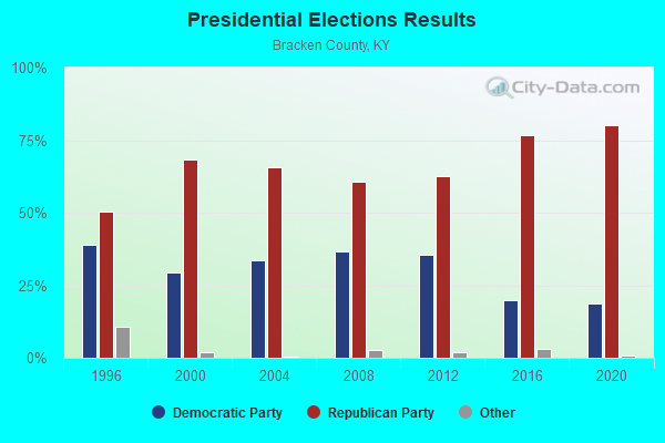
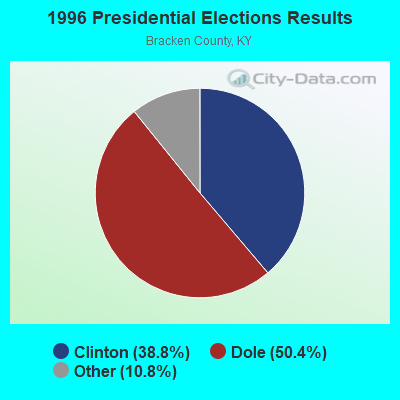
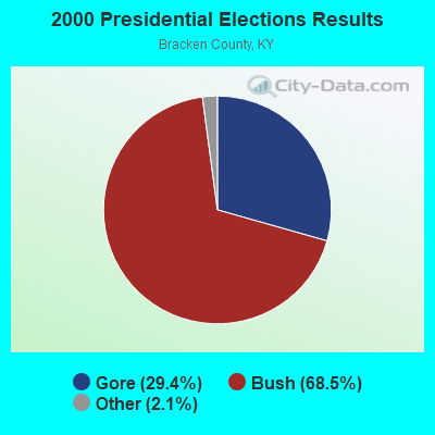
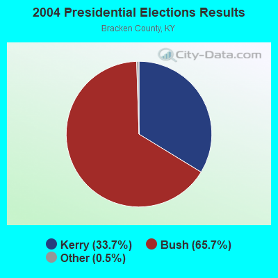
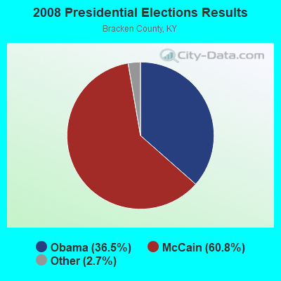
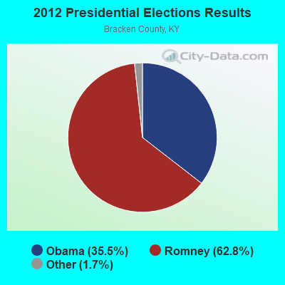
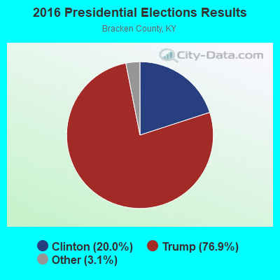
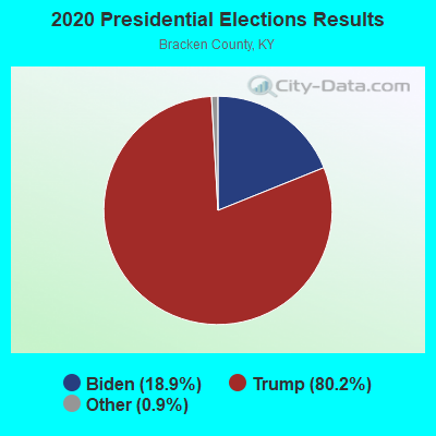
Graphs represent county-level data. Detailed 2008 Election Results
Religion statistics for Foster, KY (based on Bracken County data)
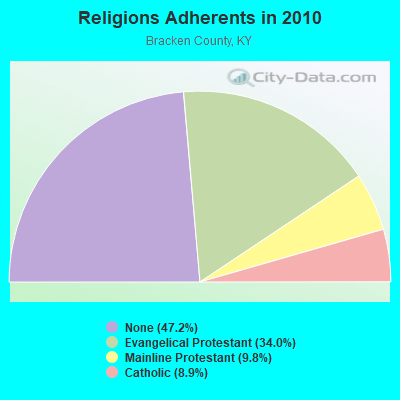
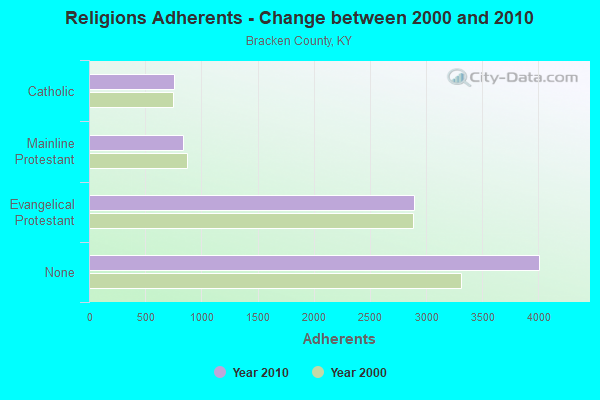
| Religion | Adherents | Congregations |
|---|---|---|
| Evangelical Protestant | 2,890 | 22 |
| Mainline Protestant | 834 | 12 |
| Catholic | 755 | 2 |
| None | 4,009 | - |
Food Environment Statistics:
| This county: | 3.51 / 10,000 pop. |
| Kentucky: | 2.19 / 10,000 pop. |
| Bracken County: | 4.68 / 10,000 pop. |
| Kentucky: | 4.36 / 10,000 pop. |
| Bracken County: | 5.85 / 10,000 pop. |
| Kentucky: | 5.74 / 10,000 pop. |
| Here: | 11.1% |
| Kentucky: | 11.0% |
| Bracken County: | 31.6% |
| Kentucky: | 30.0% |
| Here: | 22.3% |
| Kentucky: | 15.9% |
Strongest AM radio stations in Foster:
- WLW (700 AM; 50 kW; CINCINNATI, OH; Owner: JACOR BROADCASTING CORPORATION)
- WSAI (1530 AM; 50 kW; CINCINNATI, OH; Owner: JACOR BROADCASTING CORPORATION)
- WKRC (550 AM; 5 kW; CINCINNATI, OH; Owner: JACOR BROADCASTING CORPORATION)
- WHAS (840 AM; 50 kW; LOUISVILLE, KY; Owner: CLEAR CHANNEL BROADCASTING LICENSES, INC.)
- WTVN (610 AM; 50 kW; COLUMBUS, OH; Owner: CITICASTERS LICENSES, L.P.)
- WBOB (1160 AM; 5 kW; FLORENCE, KY; Owner: CARON BROADCASTING, INC.)
- WLAP (630 AM; 5 kW; LEXINGTON, KY; Owner: CITICASTERS LICENSES, L.P.)
- WVLK (590 AM; 5 kW; LEXINGTON, KY; Owner: CUMULUS LICENSING CORP.)
- WXRA (1580 AM; 10 kW; GEORGETOWN, KY; Owner: CITICASTERS LICENSES, L.P.)
- WCIN (1480 AM; 5 kW; CINCINNATI, OH)
- WCKY (1360 AM; 5 kW; CINCINNATI, OH; Owner: JACOR BROADCASTING CORPORATION)
- WRFD (880 AM; daytime; 23 kW; COLUMBUS-WORTHINGTON, OH; Owner: SALEM MEDIA OF OHIO, INC.)
- WIBC (1070 AM; 50 kW; INDIANAPOLIS, IN; Owner: EMMIS RADIO LICENSE CORPORATION)
Strongest FM radio stations in Foster:
- WIOK (107.5 FM; FALMOUTH, KY; Owner: HAMMOND BROADCASTING, INC.)
- WAOL (99.5 FM; RIPLEY, OH; Owner: RICHARD L. PLESSINGER, SR.)
- WUBE-FM (105.1 FM; CINCINNATI, OH; Owner: INFINITY RADIO OPERATIONS INC.)
- WKRQ (101.9 FM; CINCINNATI, OH; Owner: INFINITY RADIO OPERATIONS INC.)
- WKFS (107.1 FM; MILFORD, OH; Owner: JACOR BROADCASTING CORPORATION)
- WGUC (90.9 FM; CINCINNATI, OH; Owner: CINCINNATI CLASSICAL PUBLIC RADIO, INC.)
- WGRR (103.5 FM; HAMILTON, OH; Owner: INFINITY RADIO OPERATIONS INC.)
- WVMX (94.1 FM; CINCINNATI, OH; Owner: CITICASTERS LICENSES, L.P.)
- WEBN (102.7 FM; CINCINNATI, OH; Owner: JACOR BROADCASTING CORPORATION)
- WOFX-FM (92.5 FM; CINCINNATI, OH; Owner: JACOR BROADCASTING CORPORATION)
- WOBO (88.7 FM; BATAVIA, OH; Owner: WCNE EDUCATIONAL COMMUNITY RADIO,INC)
- WMOJ (94.9 FM; FAIRFIELD, OH; Owner: WVAE LICO, INC.)
- WVXU (91.7 FM; CINCINNATI, OH; Owner: XAVIER UNIVERSITY)
- WRRM (98.5 FM; CINCINNATI, OH; Owner: WRRM LICO, INC)
- WAXZ (97.7 FM; GEORGETOWN, OH; Owner: RICHARD L. PLESSINGER, SR.)
- WNKR (106.5 FM; WILLIAMSTOWN, KY; Owner: GRANT COUNTY BROADCASTERS, INC)
- WCYN-FM (102.3 FM; CYNTHIANA, KY; Owner: CUMULUS LICENSING CORP.)
- WIZF (100.9 FM; ERLANGER, KY; Owner: BLUE CHIP BROADCASTING LICENSES II, LTD.)
- WFTM-FM (95.9 FM; MAYSVILLE, KY; Owner: STANDARD TOBACCO COMPANY, INC.)
- WNKU (89.7 FM; HIGHLAND HEIGHTS, KY; Owner: BD. OF REGENTS ON N. KY UNIV.)
TV broadcast stations around Foster:
- WLWT (Channel 5; CINCINNATI, OH; Owner: OHIO/OKLAHOMA HEARST-ARGYLE TV, INC)
- WCPO-TV (Channel 9; CINCINNATI, OH; Owner: SCRIPPS HOWARD BROADCASTING COMPANY)
- WKRC-TV (Channel 12; CINCINNATI, OH; Owner: CITICASTERS CO.)
- WXIX-TV (Channel 19; NEWPORT, KY; Owner: RAYCOM NATIONAL, INC.)
- WSTR-TV (Channel 64; CINCINNATI, OH; Owner: WSTR LICENSEE, INC.)
- WCET (Channel 48; CINCINNATI, OH; Owner: THE GREATER CINCINNATI TV EDUC'L. FOUNDATION)
- WOTH-LP (Channel 35; CINCINNATI, OH; Owner: ELLIOTT B. BLOCK)
- WBQC-CA (Channel 25; CINCINNATI, OH; Owner: ELLIOTT B. BLOCK)
FCC Registered Antenna Towers:
27 (See the full list of FCC Registered Antenna Towers in Foster)FCC Registered Broadcast Land Mobile Towers:
1- Lat: 38.802111 Lon: -84.214639, Call Sign: KIK918,
Assigned Frequencies: 160.785 MHz, Grant Date: 01/06/2015, Expiration Date: 03/24/2025, Registrant: Csx Transportation Inc, 6735 Southpoint Dr S, 4th Flr J958, Jacksonville, FL 32216, Phone: (904) 332-5925, Fax: (904) 332-6013, Email:
FCC Registered Microwave Towers:
2- CI72XC997, 360 Day Hill Road (Lat: 38.781694 Lon: -84.226278), Type: Ltower, Structure height: 91.4 m, Overall height: 97.5 m, Call Sign: WQSJ928,
Assigned Frequencies: 10835.0 MHz, 10835.0 MHz, 10835.0 MHz, Grant Date: 09/30/2013, Expiration Date: 09/30/2023, Cancellation Date: 05/02/2023, Certifier: Jenny Knopf, Registrant: T-Mobile Usa, Inc., 12920 Se 38th Street, Bellevue, WA 98006, Phone: (425) 383-8401, Email:
- CI13297A, 360 Day Hill Road (Lat: 38.781694 Lon: -84.226278), Type: Ltower, Structure height: 91.4 m, Overall height: 97.5 m, Call Sign: WRQU581,
Assigned Frequencies: 10835.0 MHz, 10915.0 MHz, 10835.0 MHz, 10915.0 MHz, 10835.0 MHz, 10915.0 MHz, 10835.0 MHz, 10915.0 MHz, 10835.0 MHz, 10915.0 MHz... (+12 more), Grant Date: 05/10/2022, Expiration Date: 05/10/2032, Cancellation Date: 11/07/2023, Certifier: Jenny Knopf, Registrant: T-Mobile Usa, Inc., 12920 Se 38th Street, Bellevue, WA 98006, Phone: (425) 383-8401, Email:
FCC Registered Maritime Coast & Aviation Ground Towers:
1- Rt 2 (Lat: 38.766194 Lon: -84.121056), Type: Tower, Overall height: 27 m, Call Sign: WHW595, Licensee ID: L00620168,
Assigned Frequencies: 156.450 MHz, 156.800 MHz, 156.900 MHz, Grant Date: 02/27/2004, Expiration Date: 03/02/2014, Cancellation Date: 05/03/2014, Registrant: Greater Cincinnati Marine LLC, Newport, KY 41072
FCC Registered Amateur Radio Licenses:
7- Call Sign: KF4VRJ, Licensee ID: L01356660, Grant Date: 01/30/2018, Expiration Date: 01/30/2028, Registrant: James M Swanger Mr, 3916 Willow-Lenoxburg Rd, Foster, KY 41043
- Call Sign: KU4ML, Previous Call Sign: KE4URS, Licensee ID: L00246140, Grant Date: 10/27/2014, Expiration Date: 01/18/2025, Certifier: Steven R Hornsby, Registrant: Steven R Hornsby, 1641 New Hope Rd, Foster, KY 41043
- Call Sign: WA4DEA, Grant Date: 10/18/1988, Expiration Date: 10/18/1998, Cancellation Date: 10/19/2000, Registrant: Stanley R Moorehead, R 1 Box 70, Foster, KY 41043
- Call Sign: KG4FTW, Licensee ID: L00186586, Grant Date: 10/08/2019, Expiration Date: 12/21/2029, Certifier: Russell E Groves, Registrant: Russell E Groves, 98 Wildlife Trl, Foster, KY 41043
- Call Sign: KK4IZA, Licensee ID: L01707876, Grant Date: 05/03/2012, Expiration Date: 05/03/2022, Cancellation Date: 05/05/2020, Certifier: Joshua G Jones, Registrant: Joshua G Jones, 871 Western Hills Rd, Foster, KY 41043
- Call Sign: KN4MDR, Licensee ID: L02182260, Grant Date: 05/09/2018, Expiration Date: 05/09/2028, Certifier: Dale L Saner Jr, Registrant: Dale L Saner Jr, 172 Dayhill Rd, Foster, KY 41043
- Call Sign: K4JGJ, Previous Call Sign: KK4IZA, Licensee ID: L01707876, Grant Date: 05/05/2020, Expiration Date: 05/05/2030, Certifier: Joshua G Jones, Registrant: Joshua G Jones, 871 Western Hills Rd, Foster, KY 41043
FAA Registered Aircraft:
2- Aircraft: CESSNA 182G (Category: Land, Seats: 4, Weight: Up to 12,499 Pounds, Speed: 119 mph), Engine: CONT MOTOR O-470 SERIES (230 HP) (Reciprocating)
N-Number: 2396R, N2396R, N-2396R, Serial Number: 18255496, Year manufactured: 1964, Airworthiness Date: 04/24/1964, Certificate Issue Date: 12/12/2015
Registrant (Individual): Roy A Schalk, 1141 Fisher Rd, Foster, KY 41043 - Aircraft: KROTJE PETER R TITAN II-S (Category: Land, Seats: 2, Weight: Up to 12,499 Pounds), Engine: JABIRU 2200 (85 HP) (4 Cycle)
N-Number: 65PB, N65PB, N-65PB, Serial Number: S04XXXS0HK0484, Year manufactured: 2014, Airworthiness Date: 08/05/2014, Certificate Issue Date: 06/22/2020
Registrant (Individual): Kyle T Murphy, 9906 Highway 10 N, Foster, KY 41043
2002 - 2018 National Fire Incident Reporting System (NFIRS) incidents
- Fire incident types reported to NFIRS in Foster, KY
- 4539.8%Structure Fires
- 3631.9%Outside Fires
- 2723.9%Mobile Property/Vehicle Fires
- 54.4%Other
 According to the data from the years 2002 - 2018 the average number of fire incidents per year is 7. The highest number of reported fire incidents - 17 took place in 2010, and the least - 0 in 2003. The data has a rising trend.
 When looking into fire subcategories, the most incidents belonged to: Structure Fires (39.8%), and Outside Fires (31.9%).
- 32.0%Bottled, tank, or LP gas
- 29.7%Electricity
- 14.7%Utility gas
- 13.0%Fuel oil, kerosene, etc.
- 7.1%Wood
- 2.2%No fuel used
- 1.3%Other fuel

- 40.7%Bottled, tank, or LP gas
- 36.4%Fuel oil, kerosene, etc.
- 11.9%Utility gas
- 11.0%Wood
Foster compared to Kentucky state average:
- Unemployed percentage below state average.
- Black race population percentage significantly below state average.
- Hispanic race population percentage significantly below state average.
- Median age below state average.
- Foreign-born population percentage significantly below state average.
- Renting percentage below state average.
- Length of stay since moving in significantly above state average.
- Number of rooms per house significantly below state average.
- House age significantly below state average.
- Number of college students below state average.
- Percentage of population with a bachelor's degree or higher below state average.