District 13, Bucktown, Maryland
Submit your own pictures of this city and show them to the world
- OSM Map
- General Map
- Google Map
- MSN Map

| Males: 255 | |
| Females: 226 |
| Median resident age: | 45.6 years |
| Maryland median age: | 36.0 years |
Zip code: 21613
| District 13, Bucktown: | $69,173 |
| MD: | $94,991 |
Estimated per capita income in 2022: $40,478 (it was $22,857 in 2000)
District 13, Bucktown income, earnings, and wages data
Estimated median house or condo value in 2022: $213,883 (it was $79,600 in 2000)
| District 13, Bucktown: | $213,883 |
| MD: | $398,100 |
District 13, Bucktown, MD residents, houses, and apartments details
Detailed information about poverty and poor residents in District 13, Bucktown, MD
Compare current foreclosures near your location:
| Photo | Address | Area | Beds / Baths | Price | Details |
|---|---|---|---|---|---|

|
#1
S High St
Columbus, OH 43207
|
1,678 sq. feet
|
2 baths 4 beds |
$27,500
|
show details |

|
#2
Bayberry Cir
Columbus, OH 43207
|
1,564 sq. feet
|
1 baths 3 beds |
$127,500
|
show details |

|
#3
E 21st Ave
Columbus, OH 43211
|
1,061 sq. feet
|
1 baths 3 beds |
$179,900
|
show details |

|
#4
Rockwell Rd
Columbus, OH 43207
|
1,900 sq. feet
|
2 baths 4 beds |
show details | |

|
#5
Grove Cir
Columbus, OH 43230
|
1,236 sq. feet
|
2 baths 2 beds |
show details | |

|
#6
Rohr Rd
Groveport, OH 43125
|
1,212 sq. feet
|
1 baths 3 beds |
show details | |

|
#7
Oak Rd
Columbus, OH 43217
|
1,243 sq. feet
|
2 baths 3 beds |
show details | |

|
#8
Legend
Columbus, OH 43230
|
2,100 sq. feet
|
3 baths 3 beds |
show details | |

|
#9
Thrailkill Rd
Grove City, OH 43123
|
1,670 sq. feet
|
1 baths 4 beds |
show details | |

|
#10
Basswood Rd
Columbus, OH 43207
|
910 sq. feet
|
1 baths 2 beds |
show details |
| Photo | Address | Area | Beds / Baths | Price | Details |
|---|---|---|---|---|---|

|
#11
S 8th St
Columbus, OH 43207
|
1,053 sq. feet
|
1 baths 3 beds |
show details | |

|
#12
Troutbrook Dr
Dublin, OH 43017
|
2,628 sq. feet
|
3 baths 3 beds |
show details | |

|
#13
Corbins Mill Dr
Dublin, OH 43017
|
1,330 sq. feet
|
2 baths 2 beds |
show details | |

|
#14
Linview Ave
Columbus, OH 43211
|
1,085 sq. feet
|
1 baths 2 beds |
show details | |

|
#15
Scott St
Columbus, OH 43222
|
1,920 sq. feet
|
2 baths 5 beds |
show details | |

|
#16
Slaton Ct
Columbus, OH 43235
|
1,024 sq. feet
|
2 baths 2 beds |
show details | |

|
#17
Village Park Dr
Columbus, OH 43228
|
1,345 sq. feet
|
2 baths 3 beds |
show details | |

|
#18
Bluebird Ct
Westerville, OH 43081
|
976 sq. feet
|
2 baths 3 beds |
show details | |

|
#19
E Mound St
Columbus, OH 43209
|
1,665 sq. feet
|
2 baths 4 beds |
show details | |

|
#20
Eminence Ln
Grove City, OH 43123
|
1,704 sq. feet
|
3 baths 4 beds |
show details |
| Photo | Address | Area | Beds / Baths | Price | Details |
|---|---|---|---|---|---|

|
#21
Arklow Way
Canal Winchester, OH 43110
|
980 sq. feet
|
2 baths 2 beds |
show details | |

|
#22
Gilman Rd
Columbus, OH 43228
|
1,142 sq. feet
|
3 baths 3 beds |
show details | |

|
#23
Ashby Rd
Columbus, OH 43209
|
1,129 sq. feet
|
2 baths 3 beds |
show details | |

|
#24
Passage Creek Dr
Dublin, OH 43016
|
1,504 sq. feet
|
3 baths 2 beds |
show details | |

|
#25
Boston Harbor Way
Orient, OH 43146
|
1,300 sq. feet
|
3 baths 2 beds |
show details | |

|
#26
Floribunda Dr
Columbus, OH 43209
|
1,604 sq. feet
|
2 baths 3 beds |
show details | |

|
#27
Cleggan St
Canal Winchester, OH 43110
|
1,356 sq. feet
|
3 baths 3 beds |
show details | |

|
#28
Melrose Ave
Columbus, OH 43211
|
1,488 sq. feet
|
1 baths 4 beds |
show details | |

|
#29
Karikal Dr
Westerville, OH 43081
|
1,260 sq. feet
|
2 baths 3 beds |
show details | |

|
#30
Rohr Rd
Groveport, OH 43125
|
1,926 sq. feet
|
3 baths 3 beds |
show details |
| Photo | Address | Area | Beds / Baths | Price | Details |
|---|---|---|---|---|---|

|
#31
Rhoads Ave
Columbus, OH 43207
|
1,030 sq. feet
|
1 baths 3 beds |
show details | |

|
#32
Lewis Rd
Columbus, OH 43207
|
1,976 sq. feet
|
2 baths 4 beds |
show details | |

|
#33
Battalion Pl
Galloway, OH 43119
|
1,552 sq. feet
|
2 baths 3 beds |
show details | |

|
#34
Maize Rd
Columbus, OH 43224
|
1,678 sq. feet
|
2 baths 3 beds |
show details | |

|
#35
Oakland Park Ave
Columbus, OH 43224
|
1,127 sq. feet
|
1 baths 3 beds |
show details | |

|
#36
E Livingston Ave
Reynoldsburg, OH 43068
|
1,404 sq. feet
|
2 baths 4 beds |
show details | |

|
#37
Golden Cloud Ln
Columbus, OH 43228
|
1,576 sq. feet
|
3 baths 3 beds |
show details | |

|
#38
Blendon Grove Way
Columbus, OH 43230
|
976 sq. feet
|
3 baths 2 beds |
show details | |

|
#39
San Miguel Pl
Reynoldsburg, OH 43068
|
1,024 sq. feet
|
2 baths 2 beds |
show details | |

|
#40
Meadowleigh Way
Columbus, OH 43230
|
976 sq. feet
|
3 baths 2 beds |
show details |
| Photo | Address | Area | Beds / Baths | Price | Details |
|---|---|---|---|---|---|

|
#41
Blendon Point Dr
Columbus, OH 43230
|
896 sq. feet
|
2 baths 2 beds |
show details | |

|
#42
Clement Dr
Columbus, OH 43085
|
1,078 sq. feet
|
2 baths 3 beds |
show details | |

|
#43
Oldenburgh Way
Dublin, OH 43016
|
1,566 sq. feet
|
3 baths 3 beds |
show details | |

|
#44
Lieutenant Dr
Galloway, OH 43119
|
1,848 sq. feet
|
3 baths 3 beds |
show details | |

|
#45
Sandrell Dr
Columbus, OH 43228
|
1,132 sq. feet
|
2 baths 3 beds |
show details | |

|
#46
Alderson Ct
Columbus, OH 43228
|
1,224 sq. feet
|
3 baths 3 beds |
show details | |

|
#47
Brentwood Rd
Columbus, OH 43209
|
3,716 sq. feet
|
4 baths 4 beds |
show details | |

|
#48
Meadowsview Ln
Hilliard, OH 43026
|
2,972 sq. feet
|
4 baths 4 beds |
show details | |

|
#49
Holly River Ave
Dublin, OH 43016
|
1,335 sq. feet
|
3 baths 2 beds |
show details | |

|
Check over 1 million property listings on Foreclosure.com!
|
browse all offers | |||

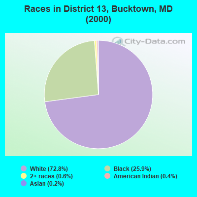
- 33872.8%White alone
- 12025.9%Black alone
- 30.6%Two or more races
- 20.4%American Indian alone
- 10.2%Asian alone
Races in District 13, Bucktown detailed stats: ancestries, foreign born residents, place of birth
 Recent articles from our blog. Our writers, many of them Ph.D. graduates or candidates, create easy-to-read articles on a wide variety of topics.
Current Local Time: EST time zone
Land area: 46.7 square miles.
Population density: 10 people per square mile (very low).

| District 13, Bucktown: | 0.9% ($720) |
| Maryland: | 1.2% ($1,782) |
Nearest city with pop. 50,000+: Bowie, MD (51.8 miles  , pop. 50,269).
Nearest city with pop. 200,000+: Washington, DC (61.5 miles , pop. 572,059).
Nearest city with pop. 1,000,000+: Philadelphia, PA (116.2 miles , pop. 1,517,550).
Nearest cities:
), ), )Latitude: 38.47 N, Longitude: 76.03 W

| Here: | 2.2% |
| Maryland: | 2.0% |
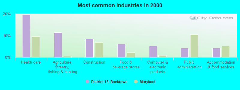
- Health care (19.6%)
- Agriculture, forestry, fishing & hunting (11.5%)
- Construction (8.6%)
- Food & beverage stores (6.2%)
- Computer & electronic products (5.3%)
- Public administration (4.3%)
- Accommodation & food services (4.3%)

- Construction (15.0%)
- Agriculture, forestry, fishing & hunting (14.2%)
- Public administration (7.5%)
- Food & beverage stores (5.8%)
- Educational services (5.8%)
- Health care (5.8%)
- Mining, quarrying, oil & gas extraction (5.0%)
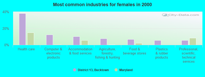
- Health care (38.2%)
- Computer & electronic products (12.4%)
- Accommodation & food services (10.1%)
- Agriculture, forestry, fishing & hunting (7.9%)
- Food & beverage stores (6.7%)
- Plastics & rubber products (5.6%)
- Professional, scientific, technical services (5.6%)
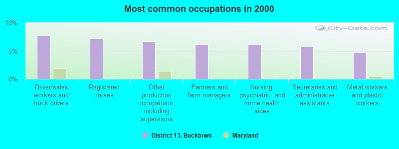
- Driver/sales workers and truck drivers (7.7%)
- Registered nurses (7.2%)
- Other production occupations, including supervisors (6.7%)
- Farmers and farm managers (6.2%)
- Nursing, psychiatric, and home health aides (6.2%)
- Secretaries and administrative assistants (5.7%)
- Metal workers and plastic workers (4.8%)
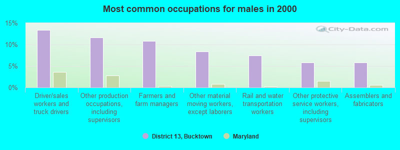
- Driver/sales workers and truck drivers (13.3%)
- Other production occupations, including supervisors (11.7%)
- Farmers and farm managers (10.8%)
- Other material moving workers, except laborers (8.3%)
- Rail and water transportation workers (7.5%)
- Other protective service workers, including supervisors (5.8%)
- Assemblers and fabricators (5.8%)
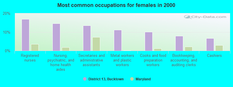
- Registered nurses (16.9%)
- Nursing, psychiatric, and home health aides (14.6%)
- Secretaries and administrative assistants (13.5%)
- Metal workers and plastic workers (11.2%)
- Cooks and food preparation workers (10.1%)
- Bookkeeping, accounting, and auditing clerks (7.9%)
- Cashiers (6.7%)
Average climate in District 13, Bucktown, Maryland
Based on data reported by over 4,000 weather stations


(lower is better)
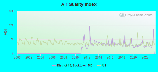
Air Quality Index (AQI) level in 2023 was 74.3. This is about average.
| City: | 74.3 |
| U.S.: | 72.6 |
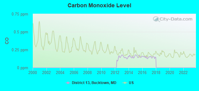
Carbon Monoxide (CO) [ppm] level in 2017 was 0.147. This is significantly better than average. Closest monitor was 10.4 miles away from the city center.
| City: | 0.147 |
| U.S.: | 0.251 |
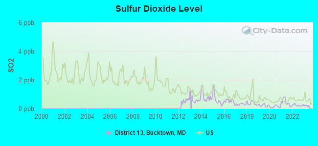
Sulfur Dioxide (SO2) [ppb] level in 2022 was 0.229. This is significantly better than average. Closest monitor was 7.7 miles away from the city center.
| City: | 0.229 |
| U.S.: | 1.515 |
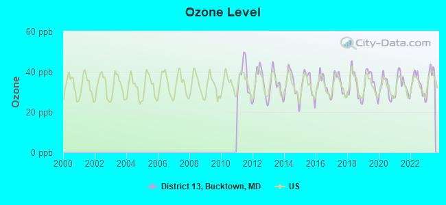
Ozone [ppb] level in 2023 was 37.8. This is about average. Closest monitor was 4.6 miles away from the city center.
| City: | 37.8 |
| U.S.: | 33.3 |
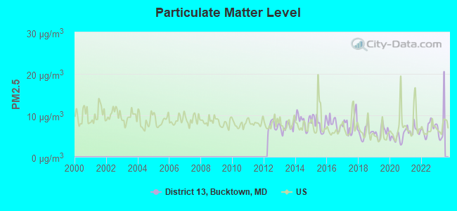
Particulate Matter (PM2.5) [µg/m3] level in 2022 was 6.98. This is about average. Closest monitor was 10.4 miles away from the city center.
| City: | 6.98 |
| U.S.: | 8.11 |
Tornado activity:
District 13, Bucktown-area historical tornado activity is below Maryland state average. It is 35% smaller than the overall U.S. average.
On 4/28/2002, a category F4 (max. wind speeds 207-260 mph) tornado 25.4 miles away from the District 13, Bucktown city center killed 3 people and injured 122 people and caused $124 million in damages.
On 4/28/2002, a category F3 (max. wind speeds 158-206 mph) tornado 13.9 miles away from the city center caused $150,000 in damages.
Earthquake activity:
District 13, Bucktown-area historical earthquake activity is significantly above Maryland state average. It is 63% smaller than the overall U.S. average.On 8/23/2011 at 17:51:04, a magnitude 5.8 (5.8 MW, Depth: 3.7 mi, Class: Moderate, Intensity: VI - VII) earthquake occurred 110.5 miles away from District 13, Bucktown center
On 1/16/1994 at 01:49:16, a magnitude 4.6 (4.6 MB, 4.6 LG, Depth: 3.1 mi, Class: Light, Intensity: IV - V) earthquake occurred 129.0 miles away from District 13, Bucktown center
On 8/25/2011 at 05:07:52, a magnitude 4.5 (4.5 ML, Depth: 4.2 mi) earthquake occurred 111.2 miles away from the city center
On 12/9/2003 at 20:59:14, a magnitude 4.5 (4.5 MB, 4.5 LG) earthquake occurred 118.7 miles away from District 13, Bucktown center
On 12/9/2003 at 20:59:18, a magnitude 4.5 (4.5 ML, Depth: 6.2 mi) earthquake occurred 122.3 miles away from the city center
On 11/30/2017 at 21:47:31, a magnitude 4.1 (4.1 MW, Depth: 6.1 mi) earthquake occurred 60.1 miles away from the city center
Magnitude types: regional Lg-wave magnitude (LG), body-wave magnitude (MB), local magnitude (ML), moment magnitude (MW)
Natural disasters:
The number of natural disasters in Dorchester County (16) is near the US average (15).Major Disasters (Presidential) Declared: 11
Emergencies Declared: 5
Causes of natural disasters: Hurricanes: 6, Winter Storms: 4, Snowstorms: 2, Storms: 2, Tornadoes: 2, Blizzard: 1, Flood: 1, Ice Storm: 1, Snowfall: 1, Tropical Storm: 1, Other: 1 (Note: some incidents may be assigned to more than one category).
Hospitals and medical centers near District 13, Bucktown:
- EASTERN SHORE HOSPITAL CENTER (Hospital, about 6 miles away; CAMBRIDGE, MD)
- CAMBRIDGE DIALYSIS CENTER (Dialysis Facility, about 8 miles away; CAMBRIDGE, MD)
- DORCHESTER GENL HOSP (Hospital, about 8 miles away; CAMBRIDGE, MD)
- DORCHESTER CNTY HLTH DEPT HHA (Home Health Center, about 8 miles away; CAMBRIDGE, MD)
- CHESAPEAKE WOODS CENTER (Nursing Home, about 9 miles away; CAMBRIDGE, MD)
- MALLARD BAY NUR AND REHAB CTR (Nursing Home, about 9 miles away; CAMBRIDGE, MD)
- SIGNATURE HEALTHCARE AT MALLARD BAY (Nursing Home, about 9 miles away; CAMBRIDGE, MD)
Colleges/universities with over 2000 students nearest to District 13, Bucktown:
- Salisbury University (about 25 miles; Salisbury, MD; Full-time enrollment: 8,375)
- University of Maryland Eastern Shore (about 26 miles; Princess Anne, MD; FT enrollment: 3,902)
- Wor-Wic Community College (about 30 miles; Salisbury, MD; FT enrollment: 2,256)
- Delaware Technical Community College-Owens (about 38 miles; Georgetown, DE; FT enrollment: 3,159)
- United States Naval Academy (about 44 miles; Annapolis, MD; FT enrollment: 5,681)
- Anne Arundel Community College (about 49 miles; Arnold, MD; FT enrollment: 10,501)
- Prince George's Community College (about 52 miles; Largo, MD; FT enrollment: 8,537)
Points of interest:
Notable locations in District 13, Bucktown: Bestpitch Ferry (A), Between the Dams (B), Ellicott's Island Volunteer Company (C). Display/hide their locations on the map
Churches in District 13, Bucktown include: Friendship Church (A), Bazzel Church (B), Scotts Chapel (C). Display/hide their locations on the map
Cemeteries: Scotts Chapel Cemetery (1), Insley Cemetery (2), Airey Cemetery (3). Display/hide their locations on the map
Lakes and swamps: Hog Rooting Pond (A), Blackwater Pond (B), Wolfpit Pond (C), Otter Pond (D), Harpers Pond (E), Goose Pond (F), Bullock Pond (G), Shorts Creek Pond (H). Display/hide their locations on the map
Streams, rivers, and creeks: Backgarden Creek (A), Bullock Creek (B), Raccoon Creek (C), Little Maple Dam Branch (D), Hughs Dam Creek (E), Pitcher Dam Creek (F). Display/hide their locations on the map
Park in District 13, Bucktown: Blackwater National Wildlife Refuge (1). Display/hide its location on the map
| This city: | 2.1 people |
| Maryland: | 2.6 people |
| This city: | 63.9% |
| Whole state: | 67.1% |
| This city: | 8.3% |
| Whole state: | 6.4% |
No gay or lesbian households reported
| This city: | 22.1% |
| Whole state: | 8.5% |
| This city: | 10.9% |
| Whole state: | 4.2% |
For population 15 years and over in District 13, Bucktown:
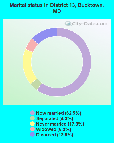
- Never married: 17.8%
- Now married: 62.5%
- Separated: 4.3%
- Widowed: 6.2%
- Divorced: 13.5%
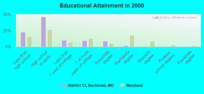
For population 25 years and over in District 13, Bucktown:
- High school or higher: 77.3%
- Bachelor's degree or higher: 1.8%
- Graduate or professional degree: 0.0%
- Unemployed: 6.3%
- Mean travel time to work (commute): 22.5 minutes
| Here: | 9.1 |
| Maryland average: | 12.7 |
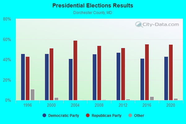
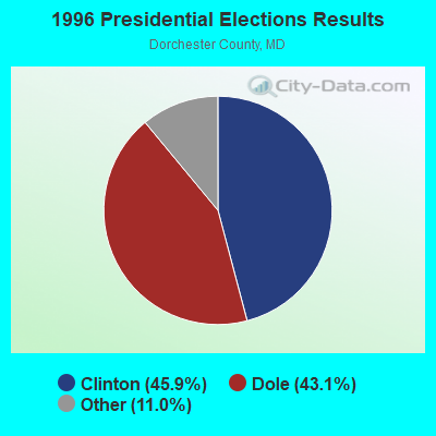

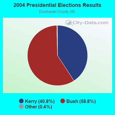
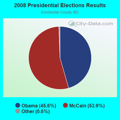
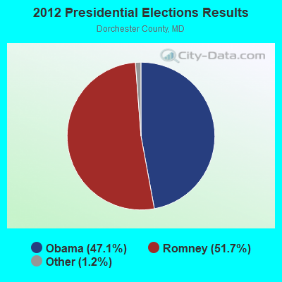
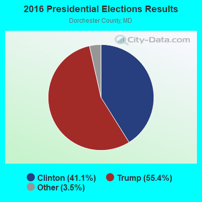
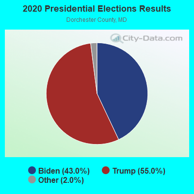
Graphs represent county-level data. Detailed 2008 Election Results
Religion statistics for District 13, Bucktown, MD (based on Dorchester County data)
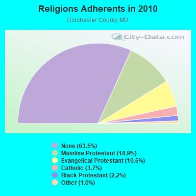
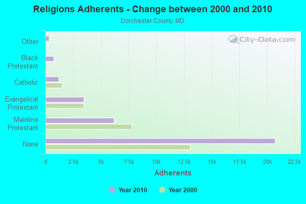
| Religion | Adherents | Congregations |
|---|---|---|
| Mainline Protestant | 6,160 | 47 |
| Evangelical Protestant | 3,460 | 31 |
| Catholic | 1,217 | 3 |
| Black Protestant | 720 | 3 |
| Other | 339 | 2 |
| None | 20,722 | - |
Food Environment Statistics:
| Here: | 2.20 / 10,000 pop. |
| Maryland: | 1.96 / 10,000 pop. |
| Dorchester County: | 1.26 / 10,000 pop. |
| State: | 1.22 / 10,000 pop. |
| Dorchester County: | 5.97 / 10,000 pop. |
| Maryland: | 2.05 / 10,000 pop. |
| This county: | 8.16 / 10,000 pop. |
| Maryland: | 5.40 / 10,000 pop. |
| Here: | 11.5% |
| Maryland: | 9.1% |
| Dorchester County: | 31.5% |
| State: | 26.7% |
| Here: | 15.0% |
| Maryland: | 15.5% |
Strongest AM radio stations in District 13, Bucktown:
- WWGB (1030 AM; daytime; 50 kW; INDIAN HEAD, MD; Owner: GOOD BODY MEDIA, LLC)
- WBIS (1190 AM; 50 kW; ANNAPOLIS, MD; Owner: NATIONS RADIO, LLC)
- WTGM (960 AM; 10 kW; SALISBURY, MD; Owner: CAPSTAR TX LIMITED PARTNERSHIP)
- WTEM (980 AM; 50 kW; WASHINGTON, DC; Owner: AMFM RADIO LICENSES, L.L.C.)
- WCBM (680 AM; 50 kW; BALTIMORE, MD; Owner: WCBM MARYLAND, INC.)
- WPGC (1580 AM; 50 kW; MORNINGSIDE, MD; Owner: INFINITY WPGC(AM), INC.)
- WCEM (1240 AM; 1 kW; CAMBRIDGE, MD; Owner: MTS BROADCASTING, L.C.)
- WWLG (1370 AM; 50 kW; BALTIMORE, MD; Owner: M-10 BROADCASTING, INC.)
- WBAL (1090 AM; 50 kW; BALTIMORE, MD; Owner: HEARST RADIO, INC.)
- WJWL (900 AM; 10 kW; GEORGETOWN, DE; Owner: GREAT SCOTT BROADCASTING)
- WJDY (1470 AM; 5 kW; SALISBURY, MD; Owner: CAPSTAR TX LIMITED PARTNERSHIP)
- WTOP (1500 AM; 50 kW; WASHINGTON, DC; Owner: BONNEVILLE HOLDING COMPANY)
- WMET (1150 AM; 50 kW; GAITHERSBURG, MD; Owner: BELTWAY ACQUISITION CORPORATION)
Strongest FM radio stations in District 13, Bucktown:
- WCEM-FM (106.3 FM; CAMBRIDGE, MD; Owner: MTS BROADCASTING L.C.)
- WAAI (100.9 FM; HURLOCK, MD; Owner: MTS BROADCASTING, L.C.)
- WINX-FM (94.3 FM; CAMBRIDGE, MD; Owner: CWA BROADCASTING, INC.)
- WSCL (89.5 FM; SALISBURY, MD; Owner: SALISBURY UNIVERSITY FOUNDATION, INC.)
- WESM (91.3 FM; PRINCESS ANNE, MD; Owner: UNIVERSITY OF MARYLAND, EASTERN SHORE)
- WLVW-FM (105.5 FM; SALISBURY, MD; Owner: CAPSTAR TX LIMITED PARTNERSHIP)
- WTDK (107.1 FM; FEDERALSBURG, MD; Owner: MTS BROADCASTING, L.C.)
- WXMD (92.5 FM; POCOMOKE CITY, MD; Owner: DELMARVA BROADCASTING COMPANY)
- WICO-FM (97.5 FM; SALISBURY, MD; Owner: DELMARVA BROADCASTING COMPANY)
- WSBY-FM (98.9 FM; SALISBURY, MD; Owner: CAPSTAR TX LIMITED PARTNERSHIP)
- WCEI-FM (96.7 FM; EASTON, MD; Owner: FIRST MEDIA RADIO, LLC)
TV broadcast stations around District 13, Bucktown:
- WMDT (Channel 47; SALISBURY, MD; Owner: DELMARVA BROADCAST SERVICE GENERAL PARTNERSHIP)
- WBOC-TV (Channel 16; SALISBURY, MD; Owner: WBOC, INC.)
- WDPB (Channel 64; SEAFORD, DE; Owner: WHYY, INC.)
- WCPB (Channel 28; SALISBURY, MD; Owner: MARYLAND PUBLIC BROADCASTING COMMISSION)
- W38BN (Channel 38; SALISBURY, MD; Owner: SALISBURY EDUCATIONAL B/CTING FOUND.)
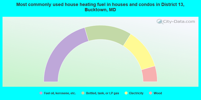
- 41.0%Fuel oil, kerosene, etc.
- 26.9%Bottled, tank, or LP gas
- 23.1%Electricity
- 9.0%Wood
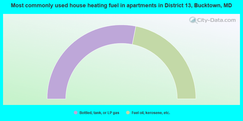
- 56.2%Bottled, tank, or LP gas
- 43.8%Fuel oil, kerosene, etc.
District 13, Bucktown compared to Maryland state average:
- Median house value below state average.
- Unemployed percentage below state average.
- Hispanic race population percentage significantly below state average.
- Median age significantly above state average.
- Foreign-born population percentage significantly below state average.
- Renting percentage below state average.
- Length of stay since moving in significantly above state average.
- Number of rooms per house significantly below state average.
- House age significantly below state average.
- Percentage of population with a bachelor's degree or higher significantly below state average.