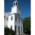
Brentwood, New Hampshire
Submit your own pictures of this town and show them to the world
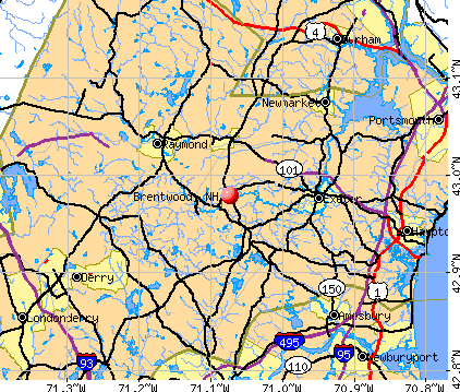
- OSM Map
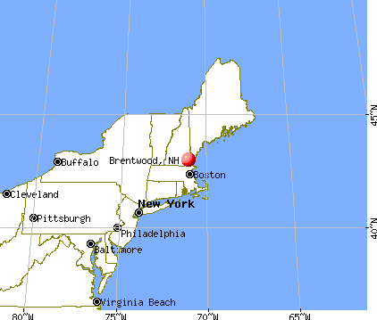
- General Map
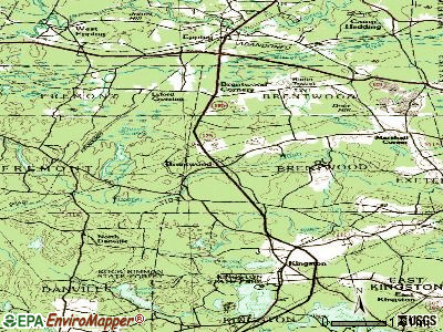
- Google Map
- MSN Map
Population change since 2000: +40.3%
| Males: 2,309 | |
| Females: 2,177 |
| Median resident age: | 41.1 years |
| New Hampshire median age: | 43.9 years |
Zip codes: 03833.
| Brentwood: | $127,436 |
| NH: | $89,992 |
Estimated per capita income in 2022: $48,352 (it was $22,027 in 2000)
Brentwood town income, earnings, and wages data
Estimated median house or condo value in 2022: $561,006 (it was $183,600 in 2000)
| Brentwood: | $561,006 |
| NH: | $384,700 |
Mean prices in 2022: all housing units: $614,227; detached houses: $665,470; townhouses or other attached units: $408,866; in 2-unit structures: $730,084; in 3-to-4-unit structures: over $1,000,000; in 5-or-more-unit structures: $329,099; mobile homes: $126,160
Detailed information about poverty and poor residents in Brentwood, NH
Compare current foreclosures near Brentwood, NH:
| Photo | Address | Area | Beds / Baths | Price | Details |
|---|---|---|---|---|---|

|
#1
Cedar St # A
Haverhill, MA 01830
|
1,134 sq. feet
|
2 baths 2 beds |
$209,300
|
show details |

|
#2
Brentwood Rd
Exeter, NH 03833
|
2,756 sq. feet
|
2 baths 3 beds |
$419,900
|
show details |

|
#3
Main St
Fremont, NH 03044
|
1,470 sq. feet
|
2 baths 4 beds |
$306,800
|
show details |

|
#4
Main St # 2
Haverhill, MA 01830
|
772 sq. feet
|
1 baths 1 beds |
show details | |

|
#5
Mount Vernon St
Haverhill, MA 01830
|
4,046 sq. feet
|
4 baths 6 beds |
show details | |

|
#6
Michael Ave
Derry, NH 03038
|
1,536 sq. feet
|
1 baths 4 beds |
show details | |

|
#7
Ccc Rd
Salisbury, MA 01952
|
2,016 sq. feet
|
3 baths 3 beds |
show details | |

|
#8
N End Blvd
Salisbury, MA 01952
|
2,816 sq. feet
|
4 baths 10 beds |
show details | |

|
#9
State Rd
Eliot, ME 03903
|
1,694 sq. feet
|
2 baths 4 beds |
show details | |

|
#10
Tsienneto Rd
Derry, NH 03038
|
1,271 sq. feet
|
2 baths 2 beds |
show details |
| Photo | Address | Area | Beds / Baths | Price | Details |
|---|---|---|---|---|---|

|
#11
Old Turnpike Rd
Nottingham, NH 03290
|
4,738 sq. feet
|
3 baths 3 beds |
show details | |

|
#12
Water St
Haverhill, MA 01830
|
1,516 sq. feet
|
3 baths 3 beds |
show details | |

|
#13
Silver St
Haverhill, MA 01832
|
2,248 sq. feet
|
1 baths 2 beds |
show details | |

|
#14
Millyard Unit 204
Amesbury, MA 01913
|
715 sq. feet
|
1 baths 1 beds |
show details | |

|
#15
Brown Ave # 2-52
Amesbury, MA 01913
|
638 sq. feet
|
1 baths 1 beds |
show details | |

|
#16
High St
Derry, NH 03038
|
2,149 sq. feet
|
3 baths 4 beds |
show details | |

|
#17
Lincoln Ave
Salisbury, MA 01952
|
1,120 sq. feet
|
1 baths 2 beds |
show details | |

|
#18
Acorn St
Haverhill, MA 01832
|
896 sq. feet
|
2 baths 2 beds |
show details | |

|
#19
Glen Ridge Rd
Raymond, NH 03077
|
1,828 sq. feet
|
2 baths 3 beds |
show details | |

|
#20
Rosemary Ln
Eliot, ME 03903
|
1,173 sq. feet
|
1 baths 4 beds |
show details |
| Photo | Address | Area | Beds / Baths | Price | Details |
|---|---|---|---|---|---|

|
#21
Everett St
Derry, NH 03038
|
1,525 sq. feet
|
1 baths 3 beds |
show details | |

|
#22
Golden Hill Ave
Haverhill, MA 01830
|
2,016 sq. feet
|
1 baths 2 beds |
show details | |

|
#23
Pike St
Salisbury, MA 01952
|
1,808 sq. feet
|
1 baths 3 beds |
show details | |

|
#24
Sanborn Rd
East Kingston, NH 03827
|
3,002 sq. feet
|
2 baths 3 beds |
show details | |

|
#25
Steeplechase Ct
Haverhill, MA 01832
|
1,442 sq. feet
|
2 baths 2 beds |
show details | |

|
#26
Main St
Plaistow, NH 03865
|
1,177 sq. feet
|
1 baths 3 beds |
show details | |

|
#27
S Lincoln St
Haverhill, MA 01835
|
2,700 sq. feet
|
2 baths 8 beds |
show details | |

|
#28
Redfield Cir
Derry, NH 03038
|
2,124 sq. feet
|
3 baths 4 beds |
show details | |

|
#29
Lawrence Rd
Salem, NH 03079
|
1,305 sq. feet
|
1 baths 1 beds |
show details | |

|
#30
Elm St
Amesbury, MA 01913
|
1,608 sq. feet
|
2 baths 4 beds |
show details |
| Photo | Address | Area | Beds / Baths | Price | Details |
|---|---|---|---|---|---|

|
#31
Old Ferry Rd
Methuen, MA 01844
|
2,482 sq. feet
|
3 baths 5 beds |
show details | |

|
#32
Washington St
Haverhill, MA 01832
|
864 sq. feet
|
1 baths 2 beds |
show details | |

|
#33
Merrill Ave
Haverhill, MA 01830
|
2,416 sq. feet
|
2 baths 4 beds |
show details | |

|
#34
Hilldale Ave # 2
Haverhill, MA 01832
|
2,000 sq. feet
|
2 baths 4 beds |
show details | |

|
#35
Floyd Rd
Derry, NH 03038
|
3,340 sq. feet
|
3 baths 4 beds |
show details | |

|
#36
Main St
Haverhill, MA 01830
|
707 sq. feet
|
1 baths 2 beds |
show details | |

|
#37
Hilldale Ave
Haverhill, MA 01832
|
1,456 sq. feet
|
2 baths 2 beds |
show details | |

|
#38
Byron St
Haverhill, MA 01835
|
2,446 sq. feet
|
1 baths 4 beds |
show details | |

|
#39
Adams Park
Rye, NH 03870
|
1,008 sq. feet
|
2 baths 3 beds |
show details | |

|
#40
Juniper Wood Dr
Haverhill, MA 01832
|
2,404 sq. feet
|
2 baths 4 beds |
show details |
| Photo | Address | Area | Beds / Baths | Price | Details |
|---|---|---|---|---|---|

|
#41
Sheridan St
Haverhill, MA 01830
|
1,365 sq. feet
|
1 baths 4 beds |
show details | |

|
#42
Tsienneto Rd Unit 39
Derry, NH 03038
|
1,936 sq. feet
|
1 baths 2 beds |
show details | |

|
#43
Storey Ave Apt 2
Newburyport, MA 01950
|
708 sq. feet
|
1 baths 2 beds |
show details | |

|
#44
Back River Rd
Dover, NH 03820
|
1,193 sq. feet
|
1 baths 3 beds |
show details | |

|
#45
Merrill Ave
Haverhill, MA 01830
|
1,150 sq. feet
|
1 baths 3 beds |
show details | |

|
#46
Bypass 28
Derry, NH 03038
|
2,300 sq. feet
|
2 baths 4 beds |
show details | |

|
#47
15th Ave
Haverhill, MA 01830
|
1,320 sq. feet
|
1 baths 3 beds |
show details | |

|
#48
1/2 Floyd Rd
Derry, NH 03038
|
2,312 sq. feet
|
2 baths 4 beds |
show details | |

|
#49
Providence Hill Rd
Atkinson, NH 03811
|
1,947 sq. feet
|
1 baths 3 beds |
show details | |

|
Check over 1 million property listings on Foreclosure.com!
|
browse all offers | |||

- 4,28195.4%White alone
- 671.5%Hispanic
- 531.2%Two or more races
- 461.0%Asian alone
- 230.5%Black alone
- 70.2%Other race alone
- 50.1%American Indian alone
- 40.09%Native Hawaiian and Other
Pacific Islander alone

Races in Brentwood detailed stats: ancestries, foreign born residents, place of birth
Type |
2009 |
2010 |
2011 |
2012 |
2013 |
2014 |
2015 |
2016 |
2017 |
2018 |
2019 |
2020 |
2021 |
2022 |
|---|---|---|---|---|---|---|---|---|---|---|---|---|---|---|
| Murders (per 100,000) | 0 (0.0) | 0 (0.0) | 0 (0.0) | 0 (0.0) | 0 (0.0) | 1 (21.0) | 0 (0.0) | 0 (0.0) | 0 (0.0) | 0 (0.0) | 0 (0.0) | 0 (0.0) | 0 (0.0) | 0 (0.0) |
| Rapes (per 100,000) | 0 (0.0) | 0 (0.0) | 1 (22.3) | 2 (44.4) | 0 (0.0) | 0 (0.0) | 0 (0.0) | 1 (20.9) | 1 (21.1) | 0 (0.0) | 1 (21.1) | 0 (0.0) | 0 (0.0) | 0 (0.0) |
| Robberies (per 100,000) | 0 (0.0) | 0 (0.0) | 0 (0.0) | 0 (0.0) | 0 (0.0) | 1 (21.0) | 0 (0.0) | 0 (0.0) | 0 (0.0) | 0 (0.0) | 0 (0.0) | 0 (0.0) | 0 (0.0) | 1 (21.7) |
| Assaults (per 100,000) | 3 (73.9) | 0 (0.0) | 0 (0.0) | 3 (66.5) | 2 (43.3) | 0 (0.0) | 4 (83.5) | 2 (41.8) | 1 (21.1) | 1 (21.1) | 0 (0.0) | 3 (66.3) | 0 (0.0) | 1 (21.7) |
| Burglaries (per 100,000) | 8 (197.2) | 13 (289.8) | 12 (267.1) | 8 (177.5) | 10 (216.5) | 8 (168.4) | 12 (250.4) | 2 (41.8) | 3 (63.3) | 2 (42.2) | 3 (63.4) | 8 (176.8) | 1 (21.4) | 0 (0.0) |
| Thefts (per 100,000) | 40 (986.0) | 41 (914.0) | 36 (801.4) | 29 (643.3) | 33 (714.3) | 28 (589.3) | 11 (229.5) | 18 (376.1) | 17 (358.4) | 24 (506.3) | 12 (253.7) | 21 (464.1) | 14 (299.0) | 10 (216.9) |
| Auto thefts (per 100,000) | 7 (172.5) | 4 (89.2) | 1 (22.3) | 1 (22.2) | 2 (43.3) | 1 (21.0) | 2 (41.7) | 3 (62.7) | 3 (63.3) | 3 (63.3) | 3 (63.4) | 1 (22.1) | 1 (21.4) | 0 (0.0) |
| Arson (per 100,000) | 1 (24.6) | 0 (0.0) | 0 (0.0) | 0 (0.0) | 0 (0.0) | 2 (42.1) | 0 (0.0) | 0 (0.0) | 0 (0.0) | 0 (0.0) | 0 (0.0) | 0 (0.0) | 0 (0.0) | 0 (0.0) |
| City-Data.com crime index | 81.8 | 64.0 | 70.3 | 88.7 | 55.8 | 85.5 | 46.7 | 48.1 | 44.9 | 32.5 | 36.6 | 46.0 | 15.2 | 19.5 |
The City-Data.com crime index weighs serious crimes and violent crimes more heavily. Higher means more crime, U.S. average is 246.1. It adjusts for the number of visitors and daily workers commuting into cities.

Crime rate in Brentwood detailed stats: murders, rapes, robberies, assaults, burglaries, thefts, arson
Full-time law enforcement employees in 2021, including police officers: 2 (2 officers - 2 male; 0 female).
| Officers per 1,000 residents here: | 0.43 |
| New Hampshire average: | 2.14 |
 Recent articles from our blog. Our writers, many of them Ph.D. graduates or candidates, create easy-to-read articles on a wide variety of topics.

 | Country (2019 replies) |
| Why Isn't NH Population Booming? (110 replies) |
| New Hampshire - Who Puts Voting Ballot in Box ? (25 replies) |
| Moving to southeast NH help!!! (48 replies) |
| Thoughts on the Free State Project (82 replies) |
| Most overrated food establishments in NH (45 replies) |
Latest news from Brentwood, NH collected exclusively by city-data.com from local newspapers, TV, and radio stations
Ancestries: Irish (21.0%), English (19.5%), French (11.8%), German (9.2%), French Canadian (8.4%), Italian (7.5%).
Current Local Time: EST time zone
Incorporated in 1742
Elevation: 123 feet
Land area: 16.8 square miles.
Population density: 267 people per square mile (very low).
115 residents are foreign born (1.0% North America, 0.9% Europe, 0.8% Latin America, 0.5% Asia, 0.4% Africa).
| This town: | 3.6% |
| New Hampshire: | 4.4% |
| Brentwood town: | 2.0% ($3,676) |
| New Hampshire: | 2.3% ($2,946) |
Nearest city with pop. 50,000+: Haverhill, MA  (14.4 miles , pop. 58,969).
Nearest city with pop. 200,000+: Boston, MA (45.9 miles , pop. 589,141).
Nearest city with pop. 1,000,000+: Bronx, NY (207.4 miles , pop. 1,332,650).
Nearest cities:
), ), ), ), ), )Latitude: 42.98 N, Longitude: 71.05 W
Area code commonly used in this area: 603


Single-family new house construction building permits:
- 2022: 44 buildings, average cost: $319,300
- 2021: 15 buildings, average cost: $242,300
- 2020: 24 buildings, average cost: $271,500
- 2019: 18 buildings, average cost: $239,700
- 2018: 6 buildings, average cost: $225,300
- 2017: 10 buildings, average cost: $199,600
- 2016: 1 building, cost: $280,000
- 2015: 1 building, cost: $240,000
- 2014: 6 buildings, average cost: $217,400
- 2013: 27 buildings, average cost: $172,200
- 2012: 28 buildings, average cost: $93,300
- 2011: 26 buildings, average cost: $143,300
- 2010: 6 buildings, average cost: $162,400
- 2009: 11 buildings, average cost: $94,500
- 2008: 18 buildings, average cost: $94,500
- 2007: 28 buildings, average cost: $94,500
- 2006: 32 buildings, average cost: $94,500
- 2005: 38 buildings, average cost: $94,500
- 2004: 39 buildings, average cost: $94,500
- 2003: 38 buildings, average cost: $94,500
- 2002: 38 buildings, average cost: $94,500
- 2001: 37 buildings, average cost: $94,500
- 2000: 39 buildings, average cost: $94,500
- 1999: 41 buildings, average cost: $94,500
- 1998: 42 buildings, average cost: $94,600
- 1997: 38 buildings, average cost: $94,200


| Here: | 2.6% |
| New Hampshire: | 2.5% |


- Educational services (9.6%)
- Health care (8.9%)
- Professional, scientific, technical services (8.0%)
- Construction (7.4%)
- Motor vehicle & parts dealers (4.6%)
- Computer & electronic products (4.5%)
- Administrative & support & waste management services (4.2%)

- Construction (12.5%)
- Professional, scientific, technical services (8.1%)
- Computer & electronic products (6.7%)
- Motor vehicle & parts dealers (5.7%)
- Administrative & support & waste management services (5.1%)
- Real estate & rental & leasing (5.1%)
- Utilities (4.4%)

- Educational services (16.6%)
- Health care (15.3%)
- Professional, scientific, technical services (7.9%)
- Accommodation & food services (6.3%)
- Finance & insurance (4.9%)
- Public administration (3.2%)
- Motor vehicle & parts dealers (3.2%)

- Other management occupations, except farmers and farm managers (6.3%)
- Retail sales workers, except cashiers (5.0%)
- Other sales and related occupations, including supervisors (4.5%)
- Driver/sales workers and truck drivers (3.5%)
- Other office and administrative support workers, including supervisors (3.4%)
- Preschool, kindergarten, elementary, and middle school teachers (3.1%)
- Electrical equipment mechanics and other installation, maintenance, and repair workers, including supervisors (3.0%)

- Other management occupations, except farmers and farm managers (7.6%)
- Retail sales workers, except cashiers (6.5%)
- Driver/sales workers and truck drivers (6.1%)
- Electrical equipment mechanics and other installation, maintenance, and repair workers, including supervisors (5.6%)
- Other sales and related occupations, including supervisors (4.4%)
- Engineers (4.3%)
- Vehicle and mobile equipment mechanics, installers, and repairers (3.9%)

- Preschool, kindergarten, elementary, and middle school teachers (5.5%)
- Secretaries and administrative assistants (5.5%)
- Other office and administrative support workers, including supervisors (5.5%)
- Other management occupations, except farmers and farm managers (4.8%)
- Other sales and related occupations, including supervisors (4.5%)
- Cashiers (4.3%)
- Material recording, scheduling, dispatching, and distributing workers (4.2%)
Average climate in Brentwood, New Hampshire
Based on data reported by over 4,000 weather stations


(lower is better)

Air Quality Index (AQI) level in 2022 was 65.2. This is about average.
| City: | 65.2 |
| U.S.: | 72.6 |

Carbon Monoxide (CO) [ppm] level in 2022 was 0.157. This is significantly better than average. Closest monitor was 15.9 miles away from the city center.
| City: | 0.157 |
| U.S.: | 0.251 |

Nitrogen Dioxide (NO2) [ppb] level in 2022 was 2.05. This is significantly better than average. Closest monitor was 7.8 miles away from the city center.
| City: | 2.05 |
| U.S.: | 5.11 |

Sulfur Dioxide (SO2) [ppb] level in 2022 was 1.00. This is significantly better than average. Closest monitor was 14.4 miles away from the city center.
| City: | 1.00 |
| U.S.: | 1.51 |

Ozone [ppb] level in 2022 was 29.7. This is about average. Closest monitor was 13.9 miles away from the city center.
| City: | 29.7 |
| U.S.: | 33.3 |

Particulate Matter (PM10) [µg/m3] level in 2022 was 12.8. This is significantly better than average. Closest monitor was 15.8 miles away from the city center.
| City: | 12.8 |
| U.S.: | 19.2 |

Particulate Matter (PM2.5) [µg/m3] level in 2022 was 6.43. This is better than average. Closest monitor was 15.1 miles away from the city center.
| City: | 6.43 |
| U.S.: | 8.11 |
Tornado activity:
Brentwood-area historical tornado activity is slightly above New Hampshire state average. It is 48% smaller than the overall U.S. average.
On 6/9/1953, a category F3 (max. wind speeds 158-206 mph) tornado 4.1 miles away from the Brentwood town center injured 5 people and caused between $5000 and $50,000 in damages.
On 9/29/1974, a category F3 tornado 26.4 miles away from the town center injured one person and caused between $50,000 and $500,000 in damages.
Earthquake activity:
Brentwood-area historical earthquake activity is significantly above New Hampshire state average. It is 73% smaller than the overall U.S. average.On 4/20/2002 at 10:50:47, a magnitude 5.3 (5.3 ML, Depth: 3.0 mi, Class: Moderate, Intensity: VI - VII) earthquake occurred 169.4 miles away from the city center
On 1/19/1982 at 00:14:42, a magnitude 4.7 (4.5 MB, 4.7 MD, 4.5 LG, Class: Light, Intensity: IV - V) earthquake occurred 45.2 miles away from Brentwood center
On 10/16/2012 at 23:12:25, a magnitude 4.7 (4.7 ML, Depth: 10.0 mi) earthquake occurred 46.7 miles away from the city center
On 10/7/1983 at 10:18:46, a magnitude 5.3 (5.1 MB, 5.3 LG, 5.1 ML) earthquake occurred 178.4 miles away from the city center
On 4/20/2002 at 10:50:47, a magnitude 5.2 (5.2 MB, 4.2 MS, 5.2 MW, 5.0 MW) earthquake occurred 169.1 miles away from Brentwood center
On 8/22/1992 at 12:20:32, a magnitude 4.8 (4.8 MB, 3.8 MS, 4.7 LG, Depth: 6.2 mi) earthquake occurred 271.0 miles away from the city center
Magnitude types: regional Lg-wave magnitude (LG), body-wave magnitude (MB), duration magnitude (MD), local magnitude (ML), surface-wave magnitude (MS), moment magnitude (MW)
Natural disasters:
The number of natural disasters in Rockingham County (26) is a lot greater than the US average (15).Major Disasters (Presidential) Declared: 17
Emergencies Declared: 9
Causes of natural disasters: Storms: 12, Floods: 9, Winter Storms: 5, Hurricanes: 4, Snowstorms: 4, Snows: 2, Winds: 2, Blizzard: 1, Snowfall: 1, Tornado: 1 (Note: some incidents may be assigned to more than one category).
Hospitals and medical centers in Brentwood:
Other hospitals and medical centers near Brentwood:
- RIVERWOODS AT EXETER (Nursing Home, about 4 miles away; EXETER, NH)
- ROCKINGHAM VNA AND HOSPICE (Home Health Center, about 5 miles away; EXETER, NH)
- COLONIAL POPLIN NURSING HOME (Nursing Home, about 5 miles away; FREMONT, NH)
- EVENTIDE HOME INC (Nursing Home, about 6 miles away; EXETER, NH)
- EXETER HOSPITAL INC Acute Care Hospitals (about 6 miles away; EXETER, NH)
- EXETER HEALTHCARE (Nursing Home, about 6 miles away; EXETER, NH)
- FMC DIALYSIS SERVICES OF EXETER (Dialysis Facility, about 7 miles away; EXETER, NH)
Airports located in Brentwood:
- Winterwood Airport (NH67) (Runways: 1)
Operable nuclear power plant near Brentwood:
- 12 miles: Seabrook in Seabrook, NH.
Colleges/universities with over 2000 students nearest to Brentwood:
- University of New Hampshire-Main Campus (about 12 miles; Durham, NH; Full-time enrollment: 15,243)
- Northern Essex Community College (about 14 miles; Haverhill, MA; FT enrollment: 4,737)
- Southern New Hampshire University (about 21 miles; Manchester, NH; FT enrollment: 16,552)
- Mount Washington College (about 22 miles; Manchester, NH; FT enrollment: 2,187)
- Merrimack College (about 23 miles; North Andover, MA; FT enrollment: 2,734)
- Saint Anselm College (about 24 miles; Manchester, NH; FT enrollment: 2,059)
- University of Massachusetts-Lowell (about 27 miles; Lowell, MA; FT enrollment: 12,341)
Private high school in Brentwood:
- SEACOAST LEARNING COLLABORATIVE (Students: 46, Location: 87 ROUTE 27, Grades: 3-12)
Public elementary/middle school in Brentwood:
- SWASEY CENTRAL SCHOOL (Students: 403, Location: 355 MIDDLE RD., Grades: PK-5)
Points of interest:
Notable locations in Brentwood: Rockingham County Farm (A), New England Dragway Incorporated (B), Mary E Bartlett Memorial Library (C), Brentwood Fire Department (D), Rockingham Regional Ambulance (E). Display/hide their locations on the map
Church in Brentwood: Pilgrim United Church of Christ (A). Display/hide its location on the map
Cemeteries: Sanborn Cemetery (1), Dudley Cemetery (2), Brentwood Cemetery (3). Display/hide their locations on the map
Reservoir: Exeter River Reservoir (A). Display/hide its location on the map
River: Little River (A). Display/hide its location on the map
Courts: District Court Exeter (10 Route 125), Exeter District Court (10 Route 125).
Birthplace of: J. W. H. Pollard - Football player and coach, Thomas Leavitt (banker) - Diplomat, Ted King (cyclist) - Racing cyclist.
Drinking water stations with addresses in Brentwood that have no violations reported:
- THREE PONDS CAMPGROUND (Population served: 100, Primary Water Source Type: Groundwater)
| This town: | 3.0 people |
| New Hampshire: | 2.5 people |
| This town: | 82.4% |
| Whole state: | 66.3% |
| This town: | 5.6% |
| Whole state: | 8.3% |
Likely homosexual households (counted as self-reported same-sex unmarried-partner households)
- Lesbian couples: 0.5% of all households
- Gay men: 0.7% of all households
| This town: | 3.7% |
| Whole state: | 6.5% |
| This town: | 1.2% |
| Whole state: | 2.8% |
220 people in nursing facilities/skilled-nursing facilities in 2010
255 people in nursing homes in 2000
214 people in local jails and other confinement facilities (including police lockups) in 2000
For population 15 years and over in Brentwood:

- Never married: 23.5%
- Now married: 58.9%
- Separated: 1.3%
- Widowed: 7.7%
- Divorced: 8.6%
For population 25 years and over in Brentwood:
- High school or higher: 86.3%
- Bachelor's degree or higher: 27.5%
- Graduate or professional degree: 10.9%
- Unemployed: 3.3%
- Mean travel time to work (commute): 27.4 minutes


| Here: | 11.9 |
| New Hampshire average: | 10.9 |


Graphs represent county-level data. Detailed 2008 Election Results
Religion statistics for Brentwood, NH (based on Rockingham County data)


| Religion | Adherents | Congregations |
|---|---|---|
| Catholic | 84,697 | 24 |
| Mainline Protestant | 19,072 | 78 |
| Evangelical Protestant | 7,456 | 61 |
| Other | 3,490 | 20 |
| Orthodox | 200 | 1 |
| None | 180,308 | - |
Food Environment Statistics:
| Rockingham County: | 1.59 / 10,000 pop. |
| New Hampshire: | 2.14 / 10,000 pop. |
| This county: | 0.17 / 10,000 pop. |
| State: | 0.15 / 10,000 pop. |
| Rockingham County: | 1.86 / 10,000 pop. |
| New Hampshire: | 1.78 / 10,000 pop. |
| Rockingham County: | 3.31 / 10,000 pop. |
| State: | 4.02 / 10,000 pop. |
| Here: | 9.56 / 10,000 pop. |
| State: | 9.70 / 10,000 pop. |
| This county: | 7.6% |
| New Hampshire: | 7.6% |
| Rockingham County: | 23.3% |
| New Hampshire: | 24.4% |
| This county: | 16.8% |
| State: | 15.9% |
7.69% of this county's 2021 resident taxpayers lived in other counties in 2020 ($114,534 average adjusted gross income)
| Here: | 7.69% |
| New Hampshire average: | 7.66% |
0.01% of residents moved from foreign countries ($203 average AGI)
Rockingham County: 0.01% New Hampshire average: 0.01%
Top counties from which taxpayers relocated into this county between 2020 and 2021:
| from Essex County, MA | |
| from Hillsborough County, NH | |
| from Middlesex County, MA |
6.82% of this county's 2020 resident taxpayers moved to other counties in 2021 ($88,778 average adjusted gross income)
| Here: | 6.82% |
| New Hampshire average: | 6.80% |
0.01% of residents moved to foreign countries ($126 average AGI)
Rockingham County: 0.01% New Hampshire average: 0.01%
Top counties to which taxpayers relocated from this county between 2020 and 2021:
| to Hillsborough County, NH | |
| to Strafford County, NH | |
| to Essex County, MA |
Businesses in Brentwood, NH
- U-Haul: 1
- UPS: 1
Strongest AM radio stations in Brentwood:
- WGIP (1540 AM; 5 kW; EXETER, NH; Owner: CAPSTAR TX LIMITED PARTNERSHIP)
- WRKO (680 AM; 50 kW; BOSTON, MA; Owner: ENTERCOM BOSTON LICENSE, LLC)
- WDER (1320 AM; 10 kW; DERRY, NH; Owner: BLOUNT COMMUNICATIONS, INC. OF NH)
- WGIN (930 AM; 10 kW; ROCHESTER, NH; Owner: CAPSTAR TX LIMITED PARTNERSHIP)
- WEEI (850 AM; 50 kW; BOSTON, MA; Owner: ENTERCOM BOSTON LICENSE, LLC)
- WBZ (1030 AM; 50 kW; BOSTON, MA; Owner: INFINITY BROADCASTING OPERATIONS, INC.)
- WWZN (1510 AM; 50 kW; BOSTON, MA; Owner: ROSE CITY RADIO CORPORATION)
- WGIR (610 AM; 5 kW; MANCHESTER, NH; Owner: CAPSTAR TX LIMITED PARTNERSHIP)
- WKOX (1200 AM; 50 kW; FRAMINGHAM, MA; Owner: CAPSTAR TX LIMITED PARTNERSHIP)
- WTSN (1270 AM; 5 kW; DOVER, NH; Owner: GARRISON CITY BROADCASTING, INC.)
- WBIX (1060 AM; 40 kW; NATICK, MA; Owner: LANGER BROADCASTING CORPORATION)
- WCRN (830 AM; 50 kW; WORCESTER, MA; Owner: CARTER BROADCASTING CORPORATION)
- WCEC (1110 AM; daytime; 5 kW; SALEM, NH; Owner: COSTA-EAGLE RADIO VENTURES LTD PARTNERSHIP)
Strongest FM radio stations in Brentwood:
- WXRV (92.5 FM; HAVERHILL, MA; Owner: BEANPOT BROADCASTING CORP.)
- WERZ (107.1 FM; EXETER, NH; Owner: CAPSTAR TX LIMITED PARTNERSHIP)
- WNEF (91.7 FM; NEWBURYPORT, MA; Owner: UNIVERSITY OF MASSACHUSETTS)
- WSAK (102.1 FM; HAMPTON, NH; Owner: CITADEL BROADCASTING COMPANY)
- WHEB (100.3 FM; PORTSMOUTH, NH; Owner: CAPSTAR TX LIMITED PARTNERSHIP)
- WGIR-FM (101.1 FM; MANCHESTER, NH; Owner: CAPSTAR TX LIMITED PARTNERSHIP)
- WQLL (96.5 FM; BEDFORD, NH; Owner: SAGA COMMUNICATIONS OF NEW ENGLAND, LLC)
- WLMW (90.7 FM; MANCHESTER, NH; Owner: KNOWLEDGE FOR LIFE)
- WOKQ (97.5 FM; DOVER, NH; Owner: CITADEL BROADCASTING COMPANY)
- WZID (95.7 FM; MANCHESTER, NH; Owner: SAGA COMMUNICATIONS OF NEW ENGLAND, LLC)
- WSCY (106.9 FM; MOULTONBOROUGH, NH; Owner: NORTHEAST COMMUNICATIONS CORPORATION)
- WUBB (95.3 FM; YORK CENTER, ME; Owner: CAPSTAR TX LIMITED PARTNERSHIP)
- WKLB-FM (99.5 FM; LOWELL, MA; Owner: GREATER BOSTON RADIO, INC.)
- WFEX (92.1 FM; PETERBOROUGH, NH; Owner: FNX BROADCASTING OF NEW HAMPSHIRE LLC)
- WMEX (106.5 FM; FARMINGTON, NH; Owner: WIMMEX, LLC)
- WUNH (91.3 FM; DURHAM, NH; Owner: UNIVERSITY OF NEW HAMPSHIRE)
- W227AM (93.3 FM; ANDOVER, MA; Owner: GREATER BOSTON RADIO, INC.)
- WNHI (93.3 FM; BELMONT, NH; Owner: CONCORD BROADCASTING, L.L.C.)
- WXKS-FM (107.9 FM; MEDFORD, MA; Owner: AMFM RADIO LICENSES, L.L.C.)
- WHOB (106.3 FM; NASHUA, NH; Owner: TELE-MEDIA COMPANY OF NEW HAMPSHIRE, L.L.C.)
TV broadcast stations around Brentwood:
- WHDN-LP (Channel 26; BOSTON, MA; Owner: GUENTER MARKSTEINER)
- WFXZ-CA (Channel 24; BOSTON, MA; Owner: BOSTON BROADCASTING CORP.)
- WMEA-TV (Channel 26; BIDDEFORD, ME; Owner: MAINE PUBLIC BROADCASTING CORP.)
- WENH-TV (Channel 11; DURHAM, NH; Owner: UNIVERSITY OF NEW HAMPSHIRE)
- WCVB-TV (Channel 5; BOSTON, MA; Owner: WCVB HEARST-ARGYLE TV, INC.)
- WGBH-TV (Channel 2; BOSTON, MA; Owner: WGBH EDUCATIONAL FOUNDATION)
- WMFP (Channel 62; LAWRENCE, MA; Owner: WSAH LICENSE, INC.)
- WSBK-TV (Channel 38; BOSTON, MA; Owner: VIACOM INC.)
- WBZ-TV (Channel 4; BOSTON, MA; Owner: VIACOM INC.)
- WGBX-TV (Channel 44; BOSTON, MA; Owner: WGBH EDUCATIONAL FOUNDATION)
- WLVI-TV (Channel 56; CAMBRIDGE, MA; Owner: WLVI, INC.)
- WUTF (Channel 66; MARLBOROUGH, MA; Owner: TELEFUTURA BOSTON LLC)
- WFXT (Channel 25; BOSTON, MA; Owner: FOX TELEVISION STATIONS INC.)
- WNDS (Channel 50; DERRY, NH; Owner: CTV OF DERRY, INC)
- WBPX (Channel 68; BOSTON, MA; Owner: PAXSON BOSTON-68 LICENSE, INC.)
- WPXG (Channel 21; CONCORD, NH; Owner: PAXSON BOSTON-68 LICENSE, INC.)
Medal of Honor Recipients
Medal of Honor Recipient born in Brentwood: Wheelock G. Veazey.

- National Bridge Inventory (NBI) Statistics
- 14Number of bridges
- 187ft / 57.0mTotal length
- $37,704,000Total costs
- 136,951Total average daily traffic
- 5,485Total average daily truck traffic

- New bridges - historical statistics
- 21960-1969
- 21970-1979
- 11980-1989
- 81990-1999
- 12010-2019
FCC Registered Antenna Towers:
27 (See the full list of FCC Registered Antenna Towers in Brentwood)FCC Registered Broadcast Land Mobile Towers:
11 (See the full list of FCC Registered Broadcast Land Mobile Towers in Brentwood, NH)FCC Registered Microwave Towers:
4- BRENTWOOD NH, 25 Route 27 (Lat: 43.019361 Lon: -71.035361), Type: Mast, Structure height: 76.8 m, Overall height: 78 m, Call Sign: WML628,
Assigned Frequencies: 11265.0 MHz, 6770.00 MHz, 6063.80 MHz, 10633.1 MHz, 6034.15 MHz, Grant Date: 02/23/2011, Expiration Date: 02/01/2021, Cancellation Date: 12/29/2015, Certifier: Carol L Tacker, Registrant: At&t Mobility LLC, 1120 20th Street, Nw - Suite 1000, Washington, DC 20036, Phone: (202) 457-2055, Fax: (202) 457-3073, Email:
- ROCKINGHAM, 101 North Road (Lat: 43.014056 Lon: -71.050750), Type: Tower, Structure height: 10.4 m, Overall height: 37.8 m, Call Sign: WPST333,
Assigned Frequencies: 6655.62 MHz, 6685.00 MHz, Grant Date: 05/25/2021, Expiration Date: 07/30/2031, Certifier: James R Kowalik, Registrant: Nh Dept. Of Safety/Emergency Services And Communications, 33 Hazen Dr (Mailing), Concord, NH 03305, Phone: (603) 528-7541, Fax: (603) 271-6629, Email:
- BOS2621, 230 Tower Hill Road (Lat: 43.039500 Lon: -71.358861), Type: Tower, Structure height: 57.9 m, Call Sign: WQGG934, Licensee ID: L01728370,
Assigned Frequencies: 10835.0 MHz, 10795.0 MHz, Grant Date: 01/16/2007, Expiration Date: 01/16/2017, Cancellation Date: 09/10/2013, Certifier: Joseph M Sandri Jr., Registrant: Fibertower Network Services, Corp., Debtor-In-Possession, 1875 Eye Street, Nw, 5th Floor, Room 505, Washington, DC 20006, Phone: (202) 223-1028, Email:
- STATION, North Road (New Jail) (Lat: 43.013139 Lon: -71.049500), Structure height: 18.9 m, Call Sign: WHI353,
Assigned Frequencies: 957.600 MHz, Grant Date: 07/08/1997, Expiration Date: 10/01/2002, Cancellation Date: 01/12/2003, Phone: (603) 679-2225
FCC Registered Paging Towers:
2- 3.25 Miles Nw Of Route 101 And Epping Road (Lat: 43.019167 Lon: -71.035278), Type: Tower, Structure height: 76.8 m, Overall height: 78 m, Call Sign: KNKG540,
Assigned Frequencies: 931.787 MHz, Grant Date: 05/11/1999, Expiration Date: 04/01/2009, Cancellation Date: 04/21/2004, Certifier: Paul H Kuzia, Registrant: Wilkinson Barker Knauer, LLP, 2300 N Street, N.W., 7th Floor, Washington, DC 20037, Phone: (202) 783-4141, Fax: (202) 783-5851, Email:
- 25 Route 27 (Lat: 43.019250 Lon: -71.034222), Type: Tower, Structure height: 64 m, Call Sign: KNKG819, Licensee ID: L01422065,
Assigned Frequencies: 931.862 MHz, Grant Date: 08/12/2008, Expiration Date: 07/01/2018, Cancellation Date: 01/28/2014, Certifier: Shawn E Endsley, Registrant: Usa Mobility Wireless, Inc., 3000 Technology Dr. #400, Plano, TX 75074, Phone: (972) 801-0000, Fax: (972) 801-1699, Email:
FCC Registered Amateur Radio Licenses:
19 (See the full list of FCC Registered Amateur Radio Licenses in Brentwood)FAA Registered Aircraft:
3- Aircraft: PIPER J3C-65 (Category: Land, Seats: 2, Weight: Up to 12,499 Pounds, Speed: 67 mph), Engine: CONT MOTOR A&C65 SERIES (65 HP) (Reciprocating)
N-Number: 1573N, N1573N, N-1573N, Serial Number: 23105, Year manufactured: 1947, Airworthiness Date: 08/20/1955, Certificate Issue Date: 09/01/1989
Registrant (Co-Owned): Bonnie A Porter, 166 Pickpocket Rd, Brentwood, NH 03833, Other Owners: Walter C Porter - Aircraft: GULFSTREAM AMERICAN CORP AA-5B (Category: Land, Seats: 4, Weight: Up to 12,499 Pounds), Engine: LYCOMING 0-435A2-KSER (225 HP) (Reciprocating)
N-Number: 4519B, N4519B, N-4519B, Serial Number: AA5B1048, Year manufactured: 1979, Airworthiness Date: 01/02/1979, Certificate Issue Date: 05/16/2017
Registrant (Co-Owned): Andrew J Greer, 166 Pickpocket Rd, Brentwood, NH 03833, Other Owners: Walter C Porter - Aircraft: CESSNA R172K (Category: Land, Seats: 4, Weight: Up to 12,499 Pounds, Speed: 76 mph), Engine: CONT MOTOR IO-360 SER (300 HP) (Reciprocating)
N-Number: 758DR, N758DR, N-758DR, Serial Number: R1723017, Year manufactured: 1978, Airworthiness Date: 10/17/1978, Certificate Issue Date: 10/12/2010
Registrant (Individual): Terry M Savage, 108 Middle Rd, Brentwood, NH 03833
2002 - 2018 National Fire Incident Reporting System (NFIRS) incidents
- Fire incident types reported to NFIRS in Brentwood, NH
- 22452.7%Structure Fires
- 10424.5%Outside Fires
- 6214.6%Mobile Property/Vehicle Fires
- 358.2%Other
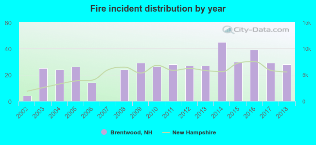 According to the data from the years 2002 - 2018 the average number of fire incidents per year is 25. The highest number of fires - 45 took place in 2014, and the least - 0 in 2007. The data has an increasing trend.
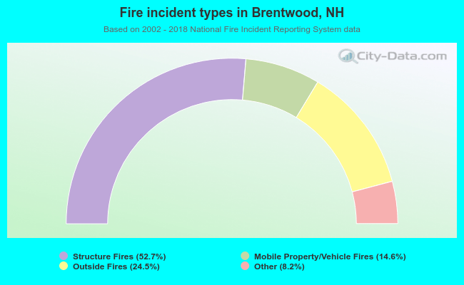 When looking into fire subcategories, the most incidents belonged to: Structure Fires (52.7%), and Outside Fires (24.5%).
- 83.0%Fuel oil, kerosene, etc.
- 8.3%Bottled, tank, or LP gas
- 5.0%Wood
- 2.7%Electricity
- 0.6%Coal or coke
- 0.5%Utility gas

- 90.5%Fuel oil, kerosene, etc.
- 9.5%Bottled, tank, or LP gas
Brentwood compared to New Hampshire state average:
- Unemployed percentage significantly below state average.
- Black race population percentage below state average.
- Hispanic race population percentage below state average.
- Foreign-born population percentage below state average.
- Renting percentage significantly below state average.
- Length of stay since moving in significantly above state average.
- Number of rooms per house significantly below state average.
- House age significantly below state average.
- Institutionalized population percentage significantly above state average.
Brentwood on our top lists:
- #75 on the list of "Top 101 cities with the largest percentage of people in local jails and other confinement facilities (including police lockups) (population 1,000+)"
- #9 on the list of "Top 101 counties with the largest decrease in the number of births per 1000 residents 2000-2006 to 2007-2013 (pop 50,000+)"
- #14 on the list of "Top 101 counties with the best general health status score of residents (1-5), 3 years of data"
- #16 on the list of "Top 101 counties with the lowest number of births per 1000 residents 2007-2013"
- #22 on the list of "Top 101 counties with the lowest Particulate Matter (PM10) Annual air pollution readings in 2012 (µg/m3)"
- #36 on the list of "Top 101 counties with the highest percentage of residents that visited a dentist within the past year"

|
|
Total of 66 patent applications in 2008-2024.