Bridge Statistics for West Monroe, Louisiana (LA)
Condition, Traffic, Stress, Structural Evaluation, Project Costs
- National Bridge Inventory (NBI) Statistics
- 44Number of bridges
- 2,323ft / 708mTotal length
- $80,413,000Total costs
- 608,313Total average daily traffic
- 47,872Total average daily truck traffic
- National Bridge Inventory (NBI) Registered Bridges for West Monroe
- No street view available for this location
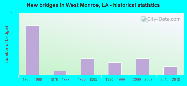
- New bridges - historical statistics
- 121960-1969
- 11970-1979
- 41980-1989
- 31990-1999
- 42000-2009
- 22010-2019

- Reconstructed bridges - Historical Statistics
- 11970-1979
- 01980-1989
- 01990-1999
- 12000-2009


- Bridge Condition - Deck
- 30.0%Good
- 60.0%Satisfactory
- 5.0%Fair
- 5.0%Serious

- Bridge Condition - Superstructure
- 40.0%Good
- 30.0%Satisfactory
- 20.0%Fair
- 10.0%Poor

- Bridge Condition - Substructure
- 5.0%Very good
- 35.0%Good
- 40.0%Satisfactory
- 15.0%Fair
- 5.0%Poor

- Bridge Condition - Channel
- 26.7%Good
- 53.3%Satisfactory
- 13.3%Fair
- 6.7%Poor

- Bridge Condition - Culverts
- 16.7%Good
- 66.7%Satisfactory
- 16.7%Fair
Find on map >> Show street view
Structure Number: 53700000000167, Location: 1.2 Mi W. of LA 143 (Lat: 32.533081, Lng: -92.165111), Route carried "on" structure: State highway 616, Year Built: 2019, Status: Open, Structure Length: 1.10m (3.61ft), Average Daily Traffic: 12,225 (year 2015), Truck Traffic: 8%, Average Future Daily Traffic: 17,300 (year 2035), Design Load: HL 93, Features Intersected: South Tupawek Bayou
Minimum Vertical Clearance: 30+ m (98+ ft), Kilometerpoint: 1.822, Lanes on structure: 2, Owner: State Highway Agency, Approaching Roadway Width: 7.6m (24.9ft), Skew: 1 degrees, Material/Design: Concrete, Design/Construction: Culvert, Number Of Spans In Main Unit: 4, Length of Maximum Span: 2.1m (6.9ft), Out-to-Out Width: 31.7m (104.0ft)
Condition: Channel: Good, Culverts: Satisfactory, Operating Rating: 39.2 metric tons, Method Used To Determine Operating Rating: Load and Resistance Factor Rating (LRFR) rating reported by rating factor(RF) method using HL-93 loadings, Inventory Rating: 30.1 metric tons, Method Used To Determine Inventory Rating: Load and Resistance Factor Rating (LRFR) rating reported by rating factor(RF) method using HL-93 loadings, Structural Evaluation: Equal to present minimum criteria, Waterway Adequacy: Equal to present minimum criteria, Approach Roadway Alignment: Better than present minimum criteria, Designated Inspection Frequency: Every 24 months, Inspection Date: October 2020
Find on map >> Show street view
Structure Number: 53700000400486, Location: 0.3 MI. NORTH OF LA 616 (Lat: 32.533819, Lng: -92.162981), Route carried "on" structure: County highway , Year Built: 2012, Status: Open, Structure Length: 2.44m (8.01ft), Average Daily Traffic: 4,200 (year 2010), Average Future Daily Traffic: 2,520 (year 2036), Design Load: HS 20, Features Intersected: SOUTH TUPAWEK CREEK, Facility Carried by Structure: KIROLI RD
Minimum Vertical Clearance: 30+ m (98+ ft), Kilometerpoint: 0.000, Lanes on structure: 2, Owner: City or Municipal Highway Agency, Approaching Roadway Width: 6.1m (20.0ft), Skew: 30 degrees, Material/Design: Concrete, Design/Construction: Slab, Number Of Spans In Main Unit: 4, Length of Maximum Span: 6.1m (20.0ft), Curb or Sidewalk Widths: Left: 0.0m, Right: 1.8m (5.9ft), Curb-To-Curb Width: 8.8m (28.9ft), Out-to-Out Width: 11.7m (38.4ft)
Condition: Deck: Good, Superstructure: Good, Substructure: Good, Channel: Good, Operating Rating: 45.7 metric tons, Method Used To Determine Operating Rating: Load and Resistance Factor Rating (LRFR) rating reported by rating factor(RF) method using HL-93 loadings, Inventory Rating: 35.3 metric tons, Method Used To Determine Inventory Rating: Load and Resistance Factor Rating (LRFR) rating reported by rating factor(RF) method using HL-93 loadings, Structural Evaluation: Better than present minimum criteria, Deck Geometry: Meets minimum limits, Waterway Adequacy: Better than present minimum criteria, Approach Roadway Alignment: Equal to present desirable criteria, Designated Inspection Frequency: Every 24 months, Inspection Date: July 2020, Deck Structure Type: Concrete Cast-file-Place, Wearing Surface/Protective System: Wearing Surface: Monolithic Concrete
Find on map >> Show street view
Structure Number: 53700670804901, Location: 2.0 MI EAST OF LA 546 (Lat: 32.413200, Lng: -92.334200), Route carried "on" structure: State highway 34, Year Built: 1976, Status: Open, Structure Length: 4.27m (14.01ft), Average Daily Traffic: 2,000 (year 2016), Truck Traffic: 15%, Average Future Daily Traffic: 1,440 (year 2036), Design Load: HS 20, Features Intersected: S CHENIERE CREEK
Minimum Vertical Clearance: 30+ m (98+ ft), Kilometerpoint: 7.746, Lanes on structure: 2, Owner: State Highway Agency, Approaching Roadway Width: 14.3m (46.9ft), Material/Design: Concrete, Design/Construction: Slab, Number Of Spans In Main Unit: 7, Length of Maximum Span: 6.1m (20.0ft), Curb-To-Curb Width: 13.4m (44.0ft), Out-to-Out Width: 14.4m (47.2ft)
Condition: Deck: Satisfactory, Superstructure: Satisfactory, Substructure: Satisfactory, Channel: Fair, Operating Rating: 71.7 metric tons, Method Used To Determine Operating Rating: Load Factor (LF), Inventory Rating: 43.5 metric tons, Method Used To Determine Inventory Rating: Load Factor (LF), Structural Evaluation: Equal to present minimum criteria, Deck Geometry: Equal to present desirable criteria, Waterway Adequacy: Better than present minimum criteria, Approach Roadway Alignment: Better than present minimum criteria, Designated Inspection Frequency: Every 24 months, Underwater Inspection Frequency: Every 60 months, Inspection Date: August 2020, Underwater Inspection Date: August 2020, Deck Structure Type: Concrete Cast-file-Place, Wearing Surface/Protective System: Wearing Surface: Monolithic Concrete
Find on map >> Show street view
Structure Number: 53700670907131, Location: LA 34 OVER I-20 (Lat: 32.497919, Lng: -92.139000), Route carried "on" structure: State highway 34, Year Built: 1965, Status: Open, Structure Length: 10.15m (33.30ft), Average Daily Traffic: 10,100 (year 2016), Truck Traffic: 9%, Average Future Daily Traffic: 12,900 (year 2036), Design Load: HS 20, Features Intersected: LA 34 OVER I-20
Minimum Vertical Clearance: 30+ m (98+ ft), Kilometerpoint: 11.768, Lanes on structure: 4, Lanes under structure: 4, Base Highway Network: Yes (Inventory Route: 67-09-1, Subroute: 10), Owner: State Highway Agency, Approaching Roadway Width: 12.2m (40.0ft), Skew: 34 degrees, Material/Design: Steel, Design/Construction: Stringer/Multi-beam, Number Of Spans In Main Unit: 6, Length of Maximum Span: 19.2m (63.0ft), Curb-To-Curb Width: 12.2m (40.0ft), Out-to-Out Width: 12.5m (41.0ft)
Condition: Deck: Satisfactory, Superstructure: Satisfactory, Substructure: Good, Operating Rating: 54.4 metric tons, Method Used To Determine Operating Rating: Load and Resistance Factor Rating (LRFR) rating reported by rating factor(RF) method using HL-93 loadings, Inventory Rating: 41.8 metric tons, Method Used To Determine Inventory Rating: Load and Resistance Factor Rating (LRFR) rating reported by rating factor(RF) method using HL-93 loadings, Structural Evaluation: Equal to present minimum criteria, Deck Geometry: High priority of replacement, Underclear: High priority of replacement, Approach Roadway Alignment: Better than present minimum criteria, Length Of Structure Improvement: 11.06m (36.29ft), Designated Inspection Frequency: Every 24 months, Inspection Date: August 2020, Bridge Improvement Cost: $943,000, Total Project Cost: $1,414,000 ( Estimate for 2016), Deck Structure Type: Concrete Cast-file-Place
Find on map >> Show street view
Structure Number: 53700670907132, Location: LA 34 OVER I-20 (Lat: 32.498361, Lng: -92.138500), Route carried "on" structure: State highway 34, Year Built: 1965, Status: Open, Structure Length: 10.15m (33.30ft), Average Daily Traffic: 10,100 (year 2016), Truck Traffic: 9%, Average Future Daily Traffic: 12,900 (year 2036), Design Load: HS 20, Features Intersected: INTERSTATE 20
Minimum Vertical Clearance: 5.03m (16.50ft), Kilometerpoint: 1.149, Lanes on structure: 4, Lanes under structure: 4, Base Highway Network: Yes (Inventory Route: 67-09-2, Subroute: 10), Owner: State Highway Agency, Approaching Roadway Width: 12.2m (40.0ft), Material/Design: Steel, Design/Construction: Stringer/Multi-beam, Number Of Spans In Main Unit: 6, Length of Maximum Span: 19.2m (63.0ft), Curb-To-Curb Width: 12.2m (40.0ft), Out-to-Out Width: 12.5m (41.0ft)
Condition: Deck: Satisfactory, Superstructure: Satisfactory, Substructure: Good, Operating Rating: 47.3 metric tons, Method Used To Determine Operating Rating: Load and Resistance Factor Rating (LRFR) rating reported by rating factor(RF) method using HL-93 loadings, Inventory Rating: 36.3 metric tons, Method Used To Determine Inventory Rating: Load and Resistance Factor Rating (LRFR) rating reported by rating factor(RF) method using HL-93 loadings, Structural Evaluation: Equal to present minimum criteria, Deck Geometry: High priority of replacement, Underclear: High priority of replacement, Approach Roadway Alignment: Better than present minimum criteria, Length Of Structure Improvement: 11.06m (36.29ft), Designated Inspection Frequency: Every 24 months, Inspection Date: August 2020, Bridge Improvement Cost: $943,000, Total Project Cost: $1,414,000 ( Estimate for 2016), Deck Structure Type: Concrete Cast-file-Place
Find on map >> Show street view
Structure Number: 53701560105641, Location: 5.64 MI N of US 80 (Lat: 32.572150, Lng: -92.291900), Route carried "on" structure: State highway 15, Year Built: 1998, Status: Open, Structure Length: 0.91m (2.99ft), Average Daily Traffic: 7,600 (year 2016), Truck Traffic: 16%, Average Future Daily Traffic: 4,500 (year 2036), Design Load: HS 20, Features Intersected: HICKS CREEK
Minimum Vertical Clearance: 30+ m (98+ ft), Kilometerpoint: 8.732, Lanes on structure: 2, Base Highway Network: Yes (Inventory Route: 156-01-1, Subroute: 10), Owner: State Highway Agency, Approaching Roadway Width: 12.2m (40.0ft), Material/Design: Steel, Design/Construction: Culvert, Number Of Spans In Main Unit: 4, Length of Maximum Span: 2.1m (6.9ft), Out-to-Out Width: 54.3m (178.1ft)
Condition: Channel: Poor, Culverts: Good, Operating Rating: 97.2 metric tons, Method Used To Determine Operating Rating: Load and Resistance Factor Rating (LRFR) rating reported by rating factor(RF) method using HL-93 loadings, Inventory Rating: 74.5 metric tons, Method Used To Determine Inventory Rating: Load and Resistance Factor Rating (LRFR) rating reported by rating factor(RF) method using HL-93 loadings, Structural Evaluation: Better than present minimum criteria, Waterway Adequacy: Equal to present desirable criteria, Approach Roadway Alignment: Equal to present desirable criteria, Designated Inspection Frequency: Every 24 months, Inspection Date: August 2020
Find on map >> Show street view
Structure Number: 53701580110121, Location: LA 546 OVER I-20 (Lat: 32.509681, Lng: -92.246500), Route carried "on" structure: State highway 546, Year Built: 2008, Status: Open, Structure Length: 9.45m (31.00ft), Average Daily Traffic: 2,200 (year 2016), Truck Traffic: 8%, Average Future Daily Traffic: 1,380 (year 2036), Design Load: HS 20, Features Intersected: INTG I-20
Minimum Vertical Clearance: 30+ m (98+ ft), Kilometerpoint: 16.216, Lanes on structure: 2, Lanes under structure: 4, Owner: State Highway Agency, Approaching Roadway Width: 12.2m (40.0ft), Skew: 3 degrees, Material/Design: Steel, Design/Construction: Stringer/Multi-beam, Number Of Spans In Main Unit: 7, Length of Maximum Span: 24.4m (80.1ft), Curb-To-Curb Width: 12.2m (40.0ft), Out-to-Out Width: 12.5m (41.0ft)
Condition: Deck: Good, Superstructure: Good, Substructure: Satisfactory, Operating Rating: 51.7 metric tons, Method Used To Determine Operating Rating: Load Factor (LF), Inventory Rating: 30.8 metric tons, Method Used To Determine Inventory Rating: Load Factor (LF), Structural Evaluation: Equal to present minimum criteria, Deck Geometry: Equal to present minimum criteria, Underclear: Better than present minimum criteria, Approach Roadway Alignment: Equal to present desirable criteria, Designated Inspection Frequency: Every 24 months, Inspection Date: August 2020, Deck Structure Type: Concrete Cast-file-Place, Wearing Surface/Protective System: Wearing Surface: Wood or Timber
Find on map >> Show street view
Structure Number: 53703150201311, Location: .3 MI NORTH OF LA 616 (Lat: 32.537081, Lng: -92.148300), Route carried "on" structure: State highway 143, Year Built: 1996, Status: Open, Structure Length: 6.10m (20.01ft), Average Daily Traffic: 11,600 (year 2016), Truck Traffic: 8%, Average Future Daily Traffic: 7,260 (year 2036), Design Load: HS 20, Features Intersected: TUPAWEK BAYOU
Minimum Vertical Clearance: 30+ m (98+ ft), Kilometerpoint: 2.102, Lanes on structure: 5, Owner: State Highway Agency, Approaching Roadway Width: 23.8m (78.1ft), Material/Design: Prestressed concrete, Design/Construction: Stringer/Multi-beam, Number Of Spans In Main Unit: 4, Length of Maximum Span: 15.2m (49.9ft), Curb-To-Curb Width: 23.8m (78.1ft), Out-to-Out Width: 24.7m (81.0ft)
Condition: Deck: Good, Superstructure: Good, Substructure: Very good, Channel: Fair, Operating Rating: 62.6 metric tons, Method Used To Determine Operating Rating: Load Factor (LF), Inventory Rating: 37.2 metric tons, Method Used To Determine Inventory Rating: Load Factor (LF), Structural Evaluation: Better than present minimum criteria, Deck Geometry: Better than present minimum criteria, Waterway Adequacy: Equal to present desirable criteria, Approach Roadway Alignment: Equal to present desirable criteria, Designated Inspection Frequency: Every 24 months, Inspection Date: October 2020, Deck Structure Type: Concrete Cast-file-Place
Find on map >> Show street view
Structure Number: 53703150203831, Location: 2.8 MI NORTH OF LA 616 (Lat: 32.569561, Lng: -92.159400), Route carried "on" structure: State highway 143, Year Built: 1962, Year Reconstructed: 1984, Status: Open, Structure Length: 20.12m (66.01ft), Average Daily Traffic: 4,400 (year 2016), Truck Traffic: 16%, Average Future Daily Traffic: 2,460 (year 2036), Design Load: HS 20, Features Intersected: D'ARBONNE BAYOU
Minimum Vertical Clearance: 30+ m (98+ ft), Kilometerpoint: 6.181, Lanes on structure: 2, Base Highway Network: Yes (Inventory Route: 315-02-1, Subroute: 10), Owner: State Highway Agency, Approaching Roadway Width: 15.2m (49.9ft), Material/Design: Steel, Design/Construction: Stringer/Multi-beam, Number Of Spans In Main Unit: 9, Length of Maximum Span: 30.5m (100.1ft), Curb-To-Curb Width: 13.4m (44.0ft), Out-to-Out Width: 14.3m (46.9ft)
Condition: Deck: Satisfactory, Superstructure: Fair, Substructure: Poor, Channel: Satisfactory, Operating Rating: 25.6 metric tons, Method Used To Determine Operating Rating: Load and Resistance Factor Rating (LRFR) rating reported by rating factor(RF) method using HL-93 loadings, Inventory Rating: 19.8 metric tons, Method Used To Determine Inventory Rating: Load and Resistance Factor Rating (LRFR) rating reported by rating factor(RF) method using HL-93 loadings, Structural Evaluation: Meets minimum limits, Deck Geometry: Better than present minimum criteria, Waterway Adequacy: Equal to present desirable criteria, Approach Roadway Alignment: Equal to present desirable criteria, Length Of Structure Improvement: 20.79m (68.21ft), Designated Inspection Frequency: Every 24 months, Underwater Inspection Frequency: Every 60 months, Other Special Inspection Frequency: Every 12 months, Inspection Date: May 2020, Underwater Inspection Date: July 2020, Other Special Inspection Date: May 2021, Bridge Improvement Cost: $1,950,000, Total Project Cost: $2,925,000 ( Estimate for 2016), Deck Structure Type: Concrete Cast-file-Place, Wearing Surface/Protective System: Wearing Surface: Monolithic Concrete
Find on map >> Show street view
Structure Number: 53704510613171, Location: 3.2 MI EAST OF LA 546 (Lat: 32.510561, Lng: -92.191900), Route carried "on" structure: State highway 3249, Year Built: 1963, Year Reconstructed: 2011, Status: Open, Structure Length: 7.99m (26.21ft), Average Daily Traffic: 21,700 (year 2016), Truck Traffic: 9%, Average Future Daily Traffic: 14,100 (year 2036), Design Load: HS 20, Features Intersected: I-20
Minimum Vertical Clearance: 30+ m (98+ ft), Kilometerpoint: 0.393, Lanes on structure: 2, Lanes under structure: 4, Base Highway Network: Yes (Inventory Route: 837-19-1, Subroute: 10), Owner: State Highway Agency, Approaching Roadway Width: 9.1m (29.9ft), Skew: 30 degrees, Material/Design: Steel, Design/Construction: Stringer/Multi-beam, Number Of Spans In Main Unit: 4, Length of Maximum Span: 25.9m (85.0ft), Curb-To-Curb Width: 8.5m (27.9ft), Out-to-Out Width: 9.3m (30.5ft)
Condition: Deck: Good, Superstructure: Good, Substructure: Satisfactory, Operating Rating: 38.1 metric tons, Method Used To Determine Operating Rating: Load Factor (LF), Inventory Rating: 22.7 metric tons, Method Used To Determine Inventory Rating: Load Factor (LF), Structural Evaluation: Somewhat better than minimum adequacy, Deck Geometry: Meets minimum limits, Underclear: High priority of corrective action, Approach Roadway Alignment: Equal to present desirable criteria, Designated Inspection Frequency: Every 24 months, Inspection Date: September 2020, Deck Structure Type: Concrete Cast-file-Place, Wearing Surface/Protective System: Wearing Surface: Monolithic Concrete
Find on map >> Show street view
Structure Number: 53704510616635, Location: .3 MI EAST OF LA 34 (Lat: 32.499181, Lng: -92.136400), Route carried "on" structure: Ramp Interstate 20, Year Built: 1965, Status: Open, Structure Length: 24.99m (81.99ft), Average Daily Traffic: 9,430 (year 2016), Truck Traffic: 25%, Average Future Daily Traffic: 4,872 (year 2036), Design Load: HS 20, Features Intersected: I-20
Minimum Vertical Clearance: 30+ m (98+ ft), Kilometerpoint: 0.200, Lanes on structure: 2, Lanes under structure: 4, Owner: State Highway Agency, Approaching Roadway Width: 13.4m (44.0ft), Skew: 39 degrees, Material/Design: Steel, Design/Construction: Stringer/Multi-beam, Number Of Spans In Main Unit: 15, Length of Maximum Span: 20.4m (66.9ft), Curb-To-Curb Width: 7.9m (25.9ft), Out-to-Out Width: 9.7m (31.8ft)
Condition: Deck: Satisfactory, Superstructure: Satisfactory, Substructure: Satisfactory, Operating Rating: 70.7 metric tons, Method Used To Determine Operating Rating: Load Factor (LF), Inventory Rating: 42.6 metric tons, Method Used To Determine Inventory Rating: Load Factor (LF), Structural Evaluation: Equal to present minimum criteria, Deck Geometry: High priority of replacement, Underclear: Somewhat better than minimum adequacy, Approach Roadway Alignment: Better than present minimum criteria, Length Of Structure Improvement: 25.42m (83.40ft), Designated Inspection Frequency: Every 24 months, Inspection Date: September 2020, Bridge Improvement Cost: $2,168,000, Total Project Cost: $3,252,000 ( Estimate for 2016), Deck Structure Type: Concrete Cast-file-Place
Find on map >> Show street view
Structure Number: 53704510616841, Location: 16.84 MI E LINCOLN PAR LN (Lat: 32.496961, Lng: -92.133100), Route carried "on" structure: Interstate 20, Year Built: 1965, Status: Open, Structure Length: 279.04m (915.49ft), Average Daily Traffic: 49,650 (year 2018), Truck Traffic: 25%, Average Future Daily Traffic: 29,016 (year 2036), Design Load: HS 20, Features Intersected: CITY ST/ICG RR/OUACHITA
Minimum Vertical Clearance: 30+ m (98+ ft), Kilometerpoint: 27.116, Lanes on structure: 2, Lanes under structure: 2, Base Highway Network: Yes (Inventory Route: 451-06-1, Subroute: 10), Owner: State Highway Agency, Approaching Roadway Width: 15.2m (49.9ft), Skew: 30 degrees, Navigation Control: Yes ( Vertical Clearance: 24.1m (79.1ft), Horizontal Clearance: 54.9m (180.1ft)), Material/Design: Steel continuous, Design/Construction: Girder and Floorbeam System, Number Of Spans In Main Unit: 8, Number Of Approach Spans: 145, Length of Maximum Span: 45.7m (149.9ft), Curb-To-Curb Width: 12.2m (40.0ft), Out-to-Out Width: 13.7m (44.9ft)
Condition: Deck: Satisfactory, Superstructure: Fair, Substructure: Satisfactory, Channel: Satisfactory, Operating Rating: 30.8 metric tons, Method Used To Determine Operating Rating: Load and Resistance Factor Rating (LRFR) rating reported by rating factor(RF) method using HL-93 loadings, Inventory Rating: 23.7 metric tons, Method Used To Determine Inventory Rating: Load and Resistance Factor Rating (LRFR) rating reported by rating factor(RF) method using HL-93 loadings, Structural Evaluation: Somewhat better than minimum adequacy, Deck Geometry: Better than present minimum criteria, Waterway Adequacy: Better than present minimum criteria, Approach Roadway Alignment: Better than present minimum criteria, Length Of Structure Improvement: 279.04m (915.49ft), Designated Inspection Frequency: Every 24 months, Underwater Inspection Frequency: Every 60 months, Inspection Date: May 2021, Underwater Inspection Date: June 2018, Bridge Improvement Cost: $23,803,000, Total Project Cost: $35,704,000 ( Estimate for 2016), Deck Structure Type: Concrete Cast-file-Place, Wearing Surface/Protective System: Wearing Surface: Monolithic Concrete
Find on map >> Show street view
Structure Number: 53704510616842, Location: 16.84 MI E LINCOLN PAR LN (Lat: 32.501000, Lng: -92.104200), Route carried "on" structure: Interstate 20, Year Built: 1965, Status: Open, Structure Length: 279.04m (915.49ft), Average Daily Traffic: 43,800 (year 2016), Truck Traffic: 25%, Average Future Daily Traffic: 29,016 (year 2036), Design Load: HS 20, Features Intersected: CITY ST/ICG RR/OUACHITA
Minimum Vertical Clearance: 30+ m (98+ ft), Kilometerpoint: 16.090, Lanes on structure: 2, Lanes under structure: 2, Base Highway Network: Yes (Inventory Route: 451-06-2, Subroute: 10), Owner: State Highway Agency, Approaching Roadway Width: 15.2m (49.9ft), Skew: 30 degrees, Navigation Control: Yes ( Vertical Clearance: 24.1m (79.1ft), Horizontal Clearance: 54.9m (180.1ft)), Material/Design: Steel continuous, Design/Construction: Girder and Floorbeam System, Number Of Spans In Main Unit: 8, Number Of Approach Spans: 145, Length of Maximum Span: 45.7m (149.9ft), Curb-To-Curb Width: 12.2m (40.0ft), Out-to-Out Width: 13.7m (44.9ft)
Condition: Deck: Satisfactory, Superstructure: Fair, Substructure: Satisfactory, Channel: Satisfactory, Operating Rating: 29.2 metric tons, Method Used To Determine Operating Rating: Load and Resistance Factor Rating (LRFR) rating reported by rating factor(RF) method using HL-93 loadings, Inventory Rating: 22.4 metric tons, Method Used To Determine Inventory Rating: Load and Resistance Factor Rating (LRFR) rating reported by rating factor(RF) method using HL-93 loadings, Structural Evaluation: Somewhat better than minimum adequacy, Deck Geometry: Better than present minimum criteria, Waterway Adequacy: Better than present minimum criteria, Approach Roadway Alignment: Better than present minimum criteria, Length Of Structure Improvement: 279.04m (915.49ft), Designated Inspection Frequency: Every 24 months, Underwater Inspection Frequency: Every 60 months, Inspection Date: May 2021, Underwater Inspection Date: November 2020, Bridge Improvement Cost: $23,803,000, Total Project Cost: $35,704,000 ( Estimate for 2016), Deck Structure Type: Concrete Cast-file-Place, Wearing Surface/Protective System: Wearing Surface: Monolithic Concrete
Find on map >> Show street view
Structure Number: 53704510617126, Location: .8 MI EAST OF LA 34 (Lat: 32.496219, Lng: -92.127400), Route carried "on" structure: Ramp Interstate 20, Year Built: 1965, Status: Open, Structure Length: 7.53m (24.70ft), Average Daily Traffic: 9,430 (year 2016), Truck Traffic: 25%, Average Future Daily Traffic: 4,872 (year 2036), Design Load: HS 20, Features Intersected: I20;RAMP 2
Minimum Vertical Clearance: 30+ m (98+ ft), Kilometerpoint: 0.154, Lanes on structure: 1, Lanes under structure: 1, Owner: State Highway Agency, Approaching Roadway Width: 5.5m (18.0ft), Material/Design: Steel, Design/Construction: Stringer/Multi-beam, Number Of Spans In Main Unit: 6, Length of Maximum Span: 20.1m (65.9ft), Curb-To-Curb Width: 5.5m (18.0ft), Out-to-Out Width: 6.3m (20.7ft)
Condition: Deck: Good, Superstructure: Good, Substructure: Good, Operating Rating: 85.3 metric tons, Method Used To Determine Operating Rating: Load Factor (LF), Inventory Rating: 50.8 metric tons, Method Used To Determine Inventory Rating: Load Factor (LF), Structural Evaluation: Better than present minimum criteria, Deck Geometry: Meets minimum limits, Approach Roadway Alignment: Better than present minimum criteria, Designated Inspection Frequency: Every 24 months, Inspection Date: September 2020, Deck Structure Type: Concrete Cast-file-Place, Wearing Surface/Protective System: Wearing Surface: Monolithic Concrete
Find on map >> Show street view
Structure Number: 53704510617187, Location: .8 MI EAST OF LA 34 (Lat: 32.495761, Lng: -92.127189), Route carried "on" structure: Ramp Interstate 20, Year Built: 1965, Status: Open, Structure Length: 5.21m (17.09ft), Average Daily Traffic: 9,430 (year 2016), Truck Traffic: 25%, Average Future Daily Traffic: 4,872 (year 2036), Design Load: HS 20, Features Intersected: I20;RAMP 3
Minimum Vertical Clearance: 30+ m (98+ ft), Kilometerpoint: 0.074, Lanes on structure: 1, Lanes under structure: 2, Owner: State Highway Agency, Approaching Roadway Width: 5.8m (19.0ft), Material/Design: Steel, Design/Construction: Stringer/Multi-beam, Number Of Spans In Main Unit: 3, Length of Maximum Span: 20.1m (65.9ft), Curb-To-Curb Width: 5.5m (18.0ft), Out-to-Out Width: 7.3m (24.0ft)
Condition: Deck: Good, Superstructure: Good, Substructure: Good, Operating Rating: 74.4 metric tons, Method Used To Determine Operating Rating: Load Factor (LF), Inventory Rating: 44.4 metric tons, Method Used To Determine Inventory Rating: Load Factor (LF), Structural Evaluation: Better than present minimum criteria, Deck Geometry: Meets minimum limits, Approach Roadway Alignment: Better than present minimum criteria, Designated Inspection Frequency: Every 24 months, Inspection Date: September 2020, Deck Structure Type: Concrete Cast-file-Place, Wearing Surface/Protective System: Wearing Surface: Monolithic Concrete
Find on map >> Show street view
Structure Number: 53704510617378, Location: 1.0 MI EAST OF LA 34 (Lat: 32.495719, Lng: -92.124550), Route carried "on" structure: Ramp Interstate 20, Year Built: 1965, Status: Open, Structure Length: 4.33m (14.21ft), Average Daily Traffic: 8,760 (year 2016), Truck Traffic: 25%, Average Future Daily Traffic: 4,836 (year 2036), Design Load: HS 20, Features Intersected: I20;RAMP 1
Minimum Vertical Clearance: 30+ m (98+ ft), Kilometerpoint: 0.100, Lanes on structure: 1, Owner: State Highway Agency, Approaching Roadway Width: 5.5m (18.0ft), Material/Design: Steel, Design/Construction: Stringer/Multi-beam, Number Of Spans In Main Unit: 3, Length of Maximum Span: 13.7m (44.9ft), Curb-To-Curb Width: 5.5m (18.0ft), Out-to-Out Width: 7.3m (24.0ft)
Condition: Deck: Satisfactory, Superstructure: Good, Substructure: Good, Operating Rating: 78.9 metric tons, Method Used To Determine Operating Rating: Load Factor (LF), Inventory Rating: 47.2 metric tons, Method Used To Determine Inventory Rating: Load Factor (LF), Structural Evaluation: Better than present minimum criteria, Deck Geometry: Meets minimum limits, Approach Roadway Alignment: Better than present minimum criteria, Designated Inspection Frequency: Every 24 months, Inspection Date: September 2020, Deck Structure Type: Concrete Cast-file-Place, Wearing Surface/Protective System: Wearing Surface: Monolithic Concrete
Find on map >> Show street view
Structure Number: 53704510617515, Location: 1.2 MI EAST OF LA 34 (Lat: 32.494831, Lng: -92.122800), Route carried "on" structure: Ramp Interstate 20, Year Built: 1965, Status: Open, Structure Length: 9.08m (29.79ft), Average Daily Traffic: 8,760 (year 2016), Truck Traffic: 25%, Average Future Daily Traffic: 4,836 (year 2036), Design Load: HS 20, Features Intersected: I20;RAMP 4
Minimum Vertical Clearance: 30+ m (98+ ft), Kilometerpoint: 0.142, Lanes on structure: 1, Lanes under structure: 2, Owner: State Highway Agency, Approaching Roadway Width: 5.5m (18.0ft), Material/Design: Steel, Design/Construction: Stringer/Multi-beam, Number Of Spans In Main Unit: 5, Length of Maximum Span: 20.7m (67.9ft), Curb-To-Curb Width: 5.5m (18.0ft), Out-to-Out Width: 6.0m (19.7ft)
Condition: Deck: Satisfactory, Superstructure: Good, Substructure: Good, Operating Rating: 83.4 metric tons, Method Used To Determine Operating Rating: Load Factor (LF), Inventory Rating: 49.9 metric tons, Method Used To Determine Inventory Rating: Load Factor (LF), Structural Evaluation: Better than present minimum criteria, Deck Geometry: Meets minimum limits, Approach Roadway Alignment: Better than present minimum criteria, Designated Inspection Frequency: Every 24 months, Inspection Date: September 2020, Deck Structure Type: Concrete Cast-file-Place, Wearing Surface/Protective System: Wearing Surface: Monolithic Concrete
Find on map >> Show street view
Structure Number: 53708371701301, Location: LA 617 OVER I-20 (Lat: 32.505300, Lng: -92.157300), Route carried "on" structure: State highway 617, Year Built: 1986, Status: Open, Structure Length: 11.92m (39.11ft), Average Daily Traffic: 31,200 (year 2016), Truck Traffic: 9%, Average Future Daily Traffic: 16,920 (year 2036), Design Load: HS 20, Features Intersected: LA 617 OVER I-20
Minimum Vertical Clearance: 30+ m (98+ ft), Kilometerpoint: 2.132, Lanes on structure: 7, Lanes under structure: 5, Base Highway Network: Yes (Inventory Route: 837-17-1, Subroute: 10), Owner: State Highway Agency, Approaching Roadway Width: 28.0m (91.9ft), Skew: 33 degrees, Material/Design: Prestressed concrete, Design/Construction: Stringer/Multi-beam, Number Of Spans In Main Unit: 4, Length of Maximum Span: 33.8m (110.9ft), Curb-To-Curb Width: 28.0m (91.9ft), Out-to-Out Width: 29.0m (95.1ft)
Condition: Deck: Satisfactory, Superstructure: Satisfactory, Substructure: Satisfactory, Operating Rating: 88.9 metric tons, Method Used To Determine Operating Rating: Load Factor (LF), Inventory Rating: 51.7 metric tons, Method Used To Determine Inventory Rating: Load Factor (LF), Structural Evaluation: Equal to present minimum criteria, Deck Geometry: Somewhat better than minimum adequacy, Underclear: Somewhat better than minimum adequacy, Approach Roadway Alignment: Equal to present desirable criteria, Designated Inspection Frequency: Every 24 months, Inspection Date: October 2020, Deck Structure Type: Concrete Cast-file-Place
Find on map >> Show street view
Structure Number: 53708371701651, Location: 1.65 MI NORTH OF I-20 (Lat: 32.510031, Lng: -92.157400), Route carried "on" structure: State highway 617, Year Built: 1981, Status: Open, Structure Length: 1.34m (4.40ft), Average Daily Traffic: 24,200 (year 2016), Truck Traffic: 9%, Average Future Daily Traffic: 13,200 (year 2036), Design Load: HS 20, Features Intersected: DRAINAGE CANAL
Minimum Vertical Clearance: 30+ m (98+ ft), Kilometerpoint: 0.806, Lanes on structure: 4, Base Highway Network: Yes (Inventory Route: 837-17-2, Subroute: 10), Owner: State Highway Agency, Approaching Roadway Width: 22.6m (74.1ft), Skew: 20 degrees, Material/Design: Concrete, Design/Construction: Culvert, Number Of Spans In Main Unit: 4, Length of Maximum Span: 3.0m (9.8ft), Curb-To-Curb Width: 22.6m (74.1ft), Out-to-Out Width: 61.0m (200.1ft)
Condition: Channel: Satisfactory, Culverts: Fair, Operating Rating: 42.1 metric tons, Method Used To Determine Operating Rating: Load and Resistance Factor Rating (LRFR) rating reported by rating factor(RF) method using HL-93 loadings, Inventory Rating: 32.4 metric tons, Method Used To Determine Inventory Rating: Load and Resistance Factor Rating (LRFR) rating reported by rating factor(RF) method using HL-93 loadings, Structural Evaluation: Somewhat better than minimum adequacy, Deck Geometry: Superior to present desirable criteria, Waterway Adequacy: Better than present minimum criteria, Approach Roadway Alignment: Better than present minimum criteria, Designated Inspection Frequency: Every 24 months, Inspection Date: October 2020, Deck Structure Type: Concrete Cast-file-Place
Find on map >> Show street view
Structure Number: 53732304920911, Location: WEST MONROE (Lat: 32.506911, Lng: -92.149219), Route carried "on" structure: County highway , Year Built: 1980, Status: Open, Structure Length: 1.52m (4.99ft), Average Daily Traffic: 300 (year 1979), Average Future Daily Traffic: 180 (year 2036), Design Load: HS 20, Features Intersected: BLACK BAYOU, Facility Carried by Structure: PARKWOOD DR
Minimum Vertical Clearance: 30+ m (98+ ft), Kilometerpoint: 0.000, Lanes on structure: 2, Owner: City or Municipal Highway Agency, Approaching Roadway Width: 7.3m (24.0ft), Material/Design: Prestressed concrete, Design/Construction: Channel Beam, Number Of Spans In Main Unit: 2, Length of Maximum Span: 7.6m (24.9ft), Curb-To-Curb Width: 9.8m (32.2ft), Out-to-Out Width: 10.8m (35.4ft)
Condition: Deck: Satisfactory, Superstructure: Fair, Substructure: Fair, Channel: Satisfactory, Operating Rating: 40.5 metric tons, Method Used To Determine Operating Rating: Load and Resistance Factor Rating (LRFR) rating reported by rating factor(RF) method using HL-93 loadings, Inventory Rating: 31.1 metric tons, Method Used To Determine Inventory Rating: Load and Resistance Factor Rating (LRFR) rating reported by rating factor(RF) method using HL-93 loadings, Structural Evaluation: Somewhat better than minimum adequacy, Deck Geometry: Better than present minimum criteria, Waterway Adequacy: Better than present minimum criteria, Approach Roadway Alignment: Equal to present desirable criteria, Designated Inspection Frequency: Every 24 months, Inspection Date: July 2020, Deck Structure Type: Concrete Precast Panels, Wearing Surface/Protective System: Wearing Surface: Bituminous
Find on map >> Show street view
Structure Number: 53732304921041, Location: 0.26 MI SW of I-20 (Lat: 32.507239, Lng: -92.172219), Route carried "on" structure: County highway , Year Built: 2002, Status: Open, Structure Length: 0.76m (2.49ft), Design Load: HS 20, Features Intersected: CREEK, Facility Carried by Structure: DOWNING PINES RD
Minimum Vertical Clearance: 30+ m (98+ ft), Kilometerpoint: 0.000, Lanes on structure: 2, Owner: City or Municipal Highway Agency, Approaching Roadway Width: 10.1m (33.1ft), Material/Design: Concrete, Design/Construction: Culvert, Number Of Spans In Main Unit: 3, Length of Maximum Span: 2.4m (7.9ft), Curb-To-Curb Width: 7.6m (24.9ft), Out-to-Out Width: 18.3m (60.0ft)
Condition: Channel: Good, Culverts: Satisfactory, Operating Rating: 42.1 metric tons, Method Used To Determine Operating Rating: Load and Resistance Factor Rating (LRFR) rating reported by rating factor(RF) method using HL-93 loadings, Inventory Rating: 32.4 metric tons, Method Used To Determine Inventory Rating: Load and Resistance Factor Rating (LRFR) rating reported by rating factor(RF) method using HL-93 loadings, Structural Evaluation: Equal to present minimum criteria, Deck Geometry: Equal to present minimum criteria, Waterway Adequacy: Equal to present desirable criteria, Approach Roadway Alignment: Equal to present desirable criteria, Designated Inspection Frequency: Every 24 months, Inspection Date: July 2020, Deck Structure Type: Concrete Cast-file-Place
Find on map >> Show street view
Structure Number: 53732305921041, Location: 0.15 MI SW of I-20 (Lat: 32.508089, Lng: -92.173350), Route carried "on" structure: County highway , Year Built: 2000, Status: Open, Structure Length: 0.76m (2.49ft), Design Load: HS 20, Features Intersected: HORSE CREEK, Facility Carried by Structure: MANE ST
Minimum Vertical Clearance: 30+ m (98+ ft), Kilometerpoint: 0.000, Lanes on structure: 2, Owner: City or Municipal Highway Agency, Approaching Roadway Width: 11.0m (36.1ft), Skew: 30 degrees, Material/Design: Concrete, Design/Construction: Culvert, Number Of Spans In Main Unit: 3, Length of Maximum Span: 2.4m (7.9ft), Curb-To-Curb Width: 15.1m (49.5ft), Out-to-Out Width: 33.5m (109.9ft)
Condition: Channel: Satisfactory, Culverts: Satisfactory, Operating Rating: 42.1 metric tons, Method Used To Determine Operating Rating: Load and Resistance Factor Rating (LRFR) rating reported by rating factor(RF) method using HL-93 loadings, Inventory Rating: 32.4 metric tons, Method Used To Determine Inventory Rating: Load and Resistance Factor Rating (LRFR) rating reported by rating factor(RF) method using HL-93 loadings, Structural Evaluation: Equal to present minimum criteria, Deck Geometry: Superior to present desirable criteria, Waterway Adequacy: Equal to present desirable criteria, Approach Roadway Alignment: High priority of corrective action, Designated Inspection Frequency: Every 24 months, Inspection Date: July 2020, Deck Structure Type: Concrete Cast-file-Place
Find on map >> Show street view
Structure Number: 53732306921041, Location: 0.08 MI S of I-20 (Lat: 32.510311, Lng: -92.174661), Route carried "on" structure: County highway , Year Built: 2000, Status: Open, Structure Length: 1.28m (4.20ft), Design Load: HS 20, Features Intersected: CONSTITUTION DRIVE, Facility Carried by Structure: DOWNING PINES RD
Minimum Vertical Clearance: 30+ m (98+ ft), Kilometerpoint: 0.000, Lanes on structure: 2, Lanes under structure: 2, Owner: City or Municipal Highway Agency, Approaching Roadway Width: 10.1m (33.1ft), Material/Design: Concrete, Design/Construction: Culvert, Number Of Spans In Main Unit: 1, Length of Maximum Span: 12.8m (42.0ft), Curb-To-Curb Width: 9.8m (32.2ft), Out-to-Out Width: 9.8m (32.2ft)
Condition: Culverts: Satisfactory, Operating Rating: 51.2 metric tons, Method Used To Determine Operating Rating: Load and Resistance Factor Rating (LRFR) rating reported by rating factor(RF) method using HL-93 loadings, Inventory Rating: 39.5 metric tons, Method Used To Determine Inventory Rating: Load and Resistance Factor Rating (LRFR) rating reported by rating factor(RF) method using HL-93 loadings, Structural Evaluation: Equal to present minimum criteria, Deck Geometry: Equal to present desirable criteria, Underclear: Meets minimum limits, Approach Roadway Alignment: Equal to present minimum criteria, Designated Inspection Frequency: Every 24 months, Inspection Date: July 2020, Deck Structure Type: Concrete Precast Panels
Find on map >> Show street view
Structure Number: 53732327920981, Location: 1.0 MI N of LA 616 (Lat: 32.543331, Lng: -92.161300), Route carried "on" structure: County highway , Year Built: 1999, Status: Open, Structure Length: 4.63m (15.19ft), Average Daily Traffic: 448 (year 1979), Average Future Daily Traffic: 268 (year 2036), Design Load: HS 20, Features Intersected: N TUPAWEK BAYOU, Facility Carried by Structure: OLD DARBONNE RD
Minimum Vertical Clearance: 30+ m (98+ ft), Kilometerpoint: 0.000, Lanes on structure: 2, Base Highway Network: Yes, Owner: County Highway Agency, Approaching Roadway Width: 8.5m (27.9ft), Material/Design: Concrete, Design/Construction: Slab, Number Of Spans In Main Unit: 8, Length of Maximum Span: 5.8m (19.0ft), Curb or Sidewalk Widths: Left: 0.0m, Right: 2.0m (6.6ft), Curb-To-Curb Width: 9.1m (29.9ft), Out-to-Out Width: 10.0m (32.8ft)
Condition: Deck: Satisfactory, Superstructure: Satisfactory, Substructure: Satisfactory, Channel: Good, Operating Rating: 37.9 metric tons, Method Used To Determine Operating Rating: Load and Resistance Factor Rating (LRFR) rating reported by rating factor(RF) method using HL-93 loadings, Inventory Rating: 29.2 metric tons, Method Used To Determine Inventory Rating: Load and Resistance Factor Rating (LRFR) rating reported by rating factor(RF) method using HL-93 loadings, Structural Evaluation: Equal to present minimum criteria, Deck Geometry: Equal to present minimum criteria, Waterway Adequacy: Equal to present desirable criteria, Approach Roadway Alignment: Better than present minimum criteria, Designated Inspection Frequency: Every 24 months, Inspection Date: April 2020, Deck Structure Type: Concrete Cast-file-Place
Find on map >> Show street view
Structure Number: 53732327920991, Location: 2.0 MILES NW W.MONROE (Lat: 32.543139, Lng: -92.163150), Route carried "on" structure: County highway , Year Built: 1980, Status: Posted for load, Structure Length: 2.29m (7.51ft), Average Daily Traffic: 300 (year 1979), Average Future Daily Traffic: 180 (year 2036), Design Load: H 15, Features Intersected: N TUPAWEK CREEK, Facility Carried by Structure: KIROLI RD
Minimum Vertical Clearance: 30+ m (98+ ft), Kilometerpoint: 0.000, Lanes on structure: 2, Owner: City or Municipal Highway Agency, Approaching Roadway Width: 6.7m (22.0ft), Material/Design: Wood or Timber, Design/Construction: Stringer/Multi-beam, Number Of Spans In Main Unit: 5, Length of Maximum Span: 4.6m (15.1ft), Curb-To-Curb Width: 7.1m (23.3ft), Out-to-Out Width: 7.5m (24.6ft)
Condition: Deck: Fair, Superstructure: Poor, Substructure: Fair, Channel: Satisfactory, Operating Rating: 20.0 metric tons, Method Used To Determine Operating Rating: Allowable Stress (AS), Inventory Rating: 14.5 metric tons, Method Used To Determine Inventory Rating: Allowable Stress (AS), Structural Evaluation: Meets minimum limits, Deck Geometry: Meets minimum limits, Waterway Adequacy: Better than present minimum criteria, Approach Roadway Alignment: Equal to present minimum criteria, Designated Inspection Frequency: Every 24 months, Other Special Inspection Frequency: Every 12 months, Inspection Date: August 2020, Other Special Inspection Date: August 2021, Deck Structure Type: Wood or Timber, Wearing Surface/Protective System: Wearing Surface: Bituminous
Find on map >> Show street view
Structure Number: 53732329921031, Location: 2.0 MI N of US 80 (Lat: 32.554289, Lng: -92.168989), Route carried "on" structure: County highway , Year Built: 1968, Status: Posted for load, Structure Length: 1.43m (4.69ft), Average Daily Traffic: 350 (year 1979), Average Future Daily Traffic: 210 (year 2036), Design Load: H 20, Features Intersected: DARBONNE BAYOU, Facility Carried by Structure: WALL WILLIAMS RD
Minimum Vertical Clearance: 30+ m (98+ ft), Kilometerpoint: 0.000, Lanes on structure: 2, Owner: County Highway Agency, Approaching Roadway Width: 7.0m (23.0ft), Material/Design: Wood or Timber, Design/Construction: Stringer/Multi-beam, Number Of Spans In Main Unit: 3, Length of Maximum Span: 4.6m (15.1ft), Curb-To-Curb Width: 7.0m (23.0ft), Out-to-Out Width: 7.3m (24.0ft)
Condition: Deck: Serious, Superstructure: Poor, Substructure: Fair, Channel: Satisfactory, Operating Rating: 28.1 metric tons, Method Used To Determine Operating Rating: Allowable Stress (AS), Inventory Rating: 20.0 metric tons, Method Used To Determine Inventory Rating: Allowable Stress (AS), Structural Evaluation: Meets minimum limits, Deck Geometry: Meets minimum limits, Waterway Adequacy: Better than present minimum criteria, Approach Roadway Alignment: Equal to present minimum criteria, Designated Inspection Frequency: Every 24 months, Other Special Inspection Frequency: Every 12 months, Inspection Date: April 2020, Other Special Inspection Date: April 2021, Deck Structure Type: Wood or Timber, Wearing Surface/Protective System: Wearing Surface: Bituminous
Find on map >> Show street view
Structure Number: 53700670907131, Location: 1.2 MI EAST OF THOMAS RD (Lat: 32.497969, Lng: -92.139281), Route carried "under" structure: Interstate 20, Structure Length: 0. m, Average Daily Traffic: 21,500 (year 2015), Features Intersected: STELLA/MILL OFF RAMP
Minimum Vertical Clearance: 5.03m (16.50ft), Kilometerpoint: 0.204, Lanes on structure: 2, Lanes under structure: 1, Length of Maximum Span: 0.0m
Find on map >> Show street view
Structure Number: 53700670907131, Location: 1.2 MI E OF THOMAS RD (Lat: 32.498061, Lng: -92.139131), Route carried "under" structure: Interstate 20, Structure Length: 0. m, Average Daily Traffic: 21,500 (year 2015), Features Intersected: STELLA/MILL OVER I-20
Minimum Vertical Clearance: 5.03m (16.50ft), Kilometerpoint: 26.545, Lanes on structure: 2, Lanes under structure: 2, Length of Maximum Span: 0.0m
Find on map >> Show street view
Structure Number: 53700670907131, Location: 1.2 MI E OF THOMAS RD (Lat: 32.498119, Lng: -92.138531), Route carried "under" structure: Interstate 20, Structure Length: 0. m, Average Daily Traffic: 21,500 (year 2015), Features Intersected: STELLA/MILL OVER I-20
Minimum Vertical Clearance: 5.06m (16.60ft), Kilometerpoint: 19.545, Lanes on structure: 2, Lanes under structure: 2, Length of Maximum Span: 0.0m
Find on map >> Show street view
Structure Number: 53700670907131, Location: 1.2 MI EAST OF THOMAS RD (Lat: 32.498181, Lng: -92.138419), Route carried "under" structure: Interstate 20, Structure Length: 0. m, Average Daily Traffic: 21,500 (year 2015), Features Intersected: STELLA/MILL OFF/ON RAMP
Minimum Vertical Clearance: 5.03m (16.50ft), Kilometerpoint: 0.560, Lanes on structure: 2, Lanes under structure: 1, Length of Maximum Span: 0.0m
Find on map >> Show street view
Structure Number: 53700670907132, Location: 1.1 MI E OF LA 617 (Lat: 32.497969, Lng: -92.139269), Route carried "under" structure: Ramp Interstate 20, Structure Length: 0. m, Average Daily Traffic: 8,180 (year 2017), Features Intersected: I-20 EB OFF-RAMP TO MILL
Minimum Vertical Clearance: 5.03m (16.50ft), Kilometerpoint: 0.193, Lanes on structure: 3, Lanes under structure: 1, Length of Maximum Span: 0.0m
Find on map >> Show street view
Structure Number: 53700670907132, Location: 1.1 MI E OF LA 617 (Lat: 32.498119, Lng: -92.138781), Route carried "under" structure: Interstate 20, Structure Length: 0. m, Average Daily Traffic: 40,900 (year 2017), Features Intersected: I-20 WB UNDER LA 34 (STE
Minimum Vertical Clearance: 5.09m (16.70ft), Kilometerpoint: 19.554, Lanes on structure: 3, Lanes under structure: 2, Length of Maximum Span: 0.0m
Find on map >> Show street view
Structure Number: 53700670907132, Location: 1.1 MI E OF LA 617 (Lat: 32.498061, Lng: -92.139131), Route carried "under" structure: Interstate 20, Structure Length: 0. m, Average Daily Traffic: 40,900 (year 2017), Features Intersected: I-20 EB UNDER LA 34 (STE
Minimum Vertical Clearance: 5.03m (16.50ft), Kilometerpoint: 26.533, Lanes on structure: 3, Lanes under structure: 2, Length of Maximum Span: 0.0m
Find on map >> Show street view
Structure Number: 53700670907132, Location: 1.1 MI E OF LA 617 (Lat: 32.498219, Lng: -92.138631), Route carried "under" structure: Ramp Interstate 20, Structure Length: 0. m, Average Daily Traffic: 8,180 (year 2017), Features Intersected: I-20 WB OFF-RAMP TO STEL
Minimum Vertical Clearance: 5.24m (17.19ft), Kilometerpoint: 0.570, Lanes on structure: 3, Lanes under structure: 2, Length of Maximum Span: 0.0m
Find on map >> Show street view
Structure Number: 53704510614171, Location: .99 MI E OF WELL RD (Lat: 32.510831, Lng: -92.174719), Route carried "under" structure: Interstate 20, Structure Length: 0. m, Average Daily Traffic: 6,220 (year 2015), Features Intersected: DOWNING PINES OVER I-20
Minimum Vertical Clearance: 4.91m (16.11ft), Kilometerpoint: 22.812, Lanes on structure: 2, Lanes under structure: 2, Length of Maximum Span: 0.0m
Find on map >> Show street view
Structure Number: 53704510614171, Location: .99 MI E OF WELL RD (Lat: 32.511111, Lng: -92.174611), Route carried "under" structure: Interstate 20, Structure Length: 0. m, Average Daily Traffic: 6,220 (year 2015), Features Intersected: DOWNING PINES OVER I-20
Minimum Vertical Clearance: 4.91m (16.11ft), Kilometerpoint: 23.302, Lanes on structure: 2, Lanes under structure: 2, Length of Maximum Span: 0.0m
Find on map >> Show street view
Structure Number: 53704510616635, Location: 1.3 MI E OF THOMAS RD (Lat: 32.497869, Lng: -92.136719), Route carried "under" structure: Interstate 20, Structure Length: 0. m, Average Daily Traffic: 8,120 (year 2015), Features Intersected: ON/OFF RAMP UNDER LA 34
Minimum Vertical Clearance: 5.43m (17.81ft), Kilometerpoint: 0.386, Lanes on structure: 2, Lanes under structure: 2, Length of Maximum Span: 0.0m
Find on map >> Show street view
Structure Number: 53704510616635, Location: 1.3 MI E OF THOMAS RD (Lat: 32.497761, Lng: -92.136689), Route carried "under" structure: Interstate 20, Structure Length: 0. m, Average Daily Traffic: 8,120 (year 2015), Features Intersected: LA 34 S RAMP TO I-20 E O
Minimum Vertical Clearance: 5.12m (16.80ft), Kilometerpoint: 19.352, Lanes on structure: 2, Lanes under structure: 2, Length of Maximum Span: 0.0m
Find on map >> Show street view
Structure Number: 53704510616635, Location: 1.3 MI E OF THOMAS RD (Lat: 32.497639, Lng: -92.136761), Route carried "under" structure: Interstate 20, Structure Length: 0. m, Average Daily Traffic: 8,120 (year 2015), Features Intersected: LA 34 S RAMP TO I-20 E O
Minimum Vertical Clearance: 4.97m (16.31ft), Kilometerpoint: 26.760, Lanes on structure: 2, Lanes under structure: 2, Length of Maximum Span: 0.0m
Find on map >> Show street view
Structure Number: 53704510616635, Location: 0.13 MI N OF I-20/MILL ST (Lat: 32.498839, Lng: -92.136700), Route carried "under" structure: Interstate 20, Structure Length: 0. m, Average Daily Traffic: 8,120 (year 2015), Features Intersected: LA 34 S RAMP OVER LA 34
Minimum Vertical Clearance: 4.88m (16.01ft), Kilometerpoint: 0.126, Lanes on structure: 2, Lanes under structure: 2, Length of Maximum Span: 0.0m
Find on map >> Show street view
Structure Number: 53704510616635, Location: 0.13 MI N OF I-20/MILL ST (Lat: 32.498889, Lng: -92.136661), Route carried "under" structure: State highway 34, Structure Length: 0. m, Average Daily Traffic: 12,450 (year 2018), Features Intersected: MILL ST UNDER LA 34 RAMP, Facility Carried by Structure: I-20
Minimum Vertical Clearance: 4.88m (16.01ft), Kilometerpoint: 12.017, Lanes on structure: 2, Lanes under structure: 2, Material/Design: Concrete, Length of Maximum Span: 0.0m
Find on map >> Show street view
Structure Number: 53708371701301, Location: 1.3 MI. W. OF STELLA MILL (Lat: 32.505661, Lng: -92.157481), Route carried "under" structure: Interstate 20, Structure Length: 0. m, Average Daily Traffic: 28,200 (year 2015), Features Intersected: THOMAS RD. OVER I-20 EXI
Minimum Vertical Clearance: 5.03m (16.50ft), Kilometerpoint: 0.174, Lanes on structure: 6, Lanes under structure: 1, Length of Maximum Span: 0.0m
Find on map >> Show street view
Structure Number: 53708371701301, Location: 1.3 MI. W. OF STELLA MILL (Lat: 32.505900, Lng: -92.157489), Route carried "under" structure: Interstate 20, Structure Length: 0. m, Average Daily Traffic: 28,200 (year 2015), Features Intersected: THOMAS RD OVER I-20 EB
Minimum Vertical Clearance: 5.18m (16.99ft), Kilometerpoint: 24.573, Lanes on structure: 6, Lanes under structure: 2, Length of Maximum Span: 0.0m
Find on map >> Show street view
Structure Number: 53708371701301, Location: 1.3 MI W OF STELLA MILL (Lat: 32.505981, Lng: -92.157169), Route carried "under" structure: Interstate 20, Structure Length: 0. m, Average Daily Traffic: 28,200 (year 2015), Features Intersected: THOMAS RD OVER I-20WB
Minimum Vertical Clearance: 4.88m (16.01ft), Kilometerpoint: 21.515, Lanes on structure: 6, Lanes under structure: 2, Length of Maximum Span: 0.0m