Bridge Statistics for West Hartford, Connecticut (CT)
Condition, Traffic, Stress, Structural Evaluation, Project Costs
- National Bridge Inventory (NBI) Statistics
- 46Number of bridges
- 420ft / 128mTotal length
- $4,540,000Total costs
- 1,373,255Total average daily traffic
- 140,249Total average daily truck traffic
- National Bridge Inventory (NBI) Registered Bridges for West Hartford
- No street view available for this location
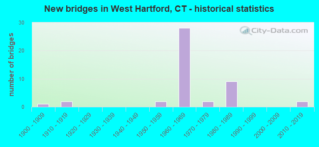
- New bridges - historical statistics
- 11900-1909
- 21910-1919
- 21950-1959
- 281960-1969
- 21970-1979
- 91980-1989
- 22010-2019

- Reconstructed bridges - Historical Statistics
- 11930-1939
- 01940-1949
- 11950-1959
- 01960-1969
- 01970-1979
- 01980-1989
- 21990-1999
- 02000-2009
- 32010-2019


- Bridge Condition - Deck
- 5.9%Very good
- 35.3%Good
- 29.4%Satisfactory
- 23.5%Fair
- 5.9%Poor

- Bridge Condition - Superstructure
- 5.9%Very good
- 41.2%Good
- 29.4%Satisfactory
- 17.6%Fair
- 5.9%Poor

- Bridge Condition - Substructure
- 41.2%Good
- 58.8%Satisfactory

- Bridge Condition - Channel
- 4.0%Very good
- 48.0%Good
- 40.0%Satisfactory
- 8.0%Fair

- Bridge Condition - Culverts
- 25.0%Good
- 62.5%Satisfactory
- 6.3%Fair
- 6.3%Serious
Find on map >> Show street view
Structure Number: 1743A, Location: 0.2 MI E OF FARMINGTON TL (Lat: 41.727575, Lng: -72.757603), Route carried "on" structure: Interstate 84, Year Built: 1965, Status: Open, Structure Length: 4.63m (15.19ft), Average Daily Traffic: 68,200 (year 2018), Truck Traffic: 9%, Average Future Daily Traffic: 101,338 (year 2038), Design Load: HS 20, Features Intersected: SR 535 (RIDGEWOOD ROAD)
Minimum Vertical Clearance: 30+ m (98+ ft), Kilometerpoint: 90.510, Lanes on structure: 4, Lanes under structure: 6, Base Highway Network: Yes, Owner: State Highway Agency, Approaching Roadway Width: 18.9m (62.0ft), Material/Design: Steel, Design/Construction: Stringer/Multi-beam, Number Of Spans In Main Unit: 2, Length of Maximum Span: 22.9m (75.1ft), Curb or Sidewalk Widths: Left: 0.4m (1.3ft), Right: 0.4m (1.3ft), Curb-To-Curb Width: 18.7m (61.4ft), Out-to-Out Width: 20.6m (67.6ft)
Condition: Deck: Fair, Superstructure: Satisfactory, Substructure: Satisfactory, Operating Rating: 55.7 metric tons, Method Used To Determine Operating Rating: Load and Resistance Factor Rating (LRFR) rating reported by rating factor(RF) method using HL-93 loadings, Inventory Rating: 42.8 metric tons, Method Used To Determine Inventory Rating: Load and Resistance Factor Rating (LRFR) rating reported by rating factor(RF) method using HL-93 loadings, Structural Evaluation: Equal to present minimum criteria, Deck Geometry: Meets minimum limits, Underclear: High priority of corrective action, Approach Roadway Alignment: Equal to present minimum criteria, Designated Inspection Frequency: Every 24 months, Inspection Date: May 2021, Deck Structure Type: Concrete Cast-file-Place, Wearing Surface/Protective System: Wearing Surface: Bituminous, Membrane: Built-up
Find on map >> Show street view
Structure Number: 1743B, Location: .25 MI E OF FARMINGTON TL (Lat: 41.727806, Lng: -72.757775), Route carried "on" structure: Interstate 84, Year Built: 1965, Year Reconstructed: 2019, Status: Open, Structure Length: 4.88m (16.01ft), Average Daily Traffic: 68,200 (year 2018), Truck Traffic: 9%, Average Future Daily Traffic: 101,338 (year 2038), Design Load: HS 20, Features Intersected: SR 535 (RIDGEWOOD ROAD)
Minimum Vertical Clearance: 30+ m (98+ ft), Kilometerpoint: 90.510, Lanes on structure: 4, Lanes under structure: 6, Base Highway Network: Yes, Owner: State Highway Agency, Approaching Roadway Width: 19.2m (63.0ft), Material/Design: Steel, Design/Construction: Stringer/Multi-beam, Number Of Spans In Main Unit: 2, Length of Maximum Span: 22.6m (74.1ft), Curb-To-Curb Width: 19.3m (63.3ft), Out-to-Out Width: 20.6m (67.6ft)
Condition: Deck: Very good, Superstructure: Very good, Substructure: Good, Operating Rating: 82.5 metric tons, Method Used To Determine Operating Rating: Load Factor (LF), Inventory Rating: 49.5 metric tons, Method Used To Determine Inventory Rating: Load Factor (LF), Structural Evaluation: Better than present minimum criteria, Deck Geometry: Somewhat better than minimum adequacy, Underclear: High priority of corrective action, Approach Roadway Alignment: Better than present minimum criteria, Designated Inspection Frequency: Every 24 months, Inspection Date: May 2021, Total Project Cost: $4,300,000 ( Estimate for 2015), Deck Structure Type: Concrete Cast-file-Place, Wearing Surface/Protective System: Wearing Surface: Bituminous, Membrane: Built-up
Find on map >> Show street view
Structure Number: 1746, Location: 1 MILE EAST FARMINGTON TL (Lat: 41.734539, Lng: -72.746725), Route carried "on" structure: Interstate 84, Year Built: 1965, Status: Open, Structure Length: 0.98m (3.22ft), Average Daily Traffic: 136,000 (year 2018), Truck Traffic: 9%, Average Future Daily Traffic: 202,082 (year 2038), Design Load: HS 20, Features Intersected: ROCKLEDGE BROOK
Minimum Vertical Clearance: 30+ m (98+ ft), Kilometerpoint: 91.781, Lanes on structure: 8, Base Highway Network: Yes, Owner: State Highway Agency, Approaching Roadway Width: 40.2m (131.9ft), Skew: 3 degrees, Material/Design: Concrete continuous, Design/Construction: Culvert, Number Of Spans In Main Unit: 2, Length of Maximum Span: 3.7m (12.1ft), Out-to-Out Width: 80.5m (264.1ft)
Condition: Channel: Satisfactory, Culverts: Satisfactory, Operating Rating: 69.0 metric tons, Method Used To Determine Operating Rating: Load and Resistance Factor Rating (LRFR) rating reported by rating factor(RF) method using HL-93 loadings, Inventory Rating: 53.1 metric tons, Method Used To Determine Inventory Rating: Load and Resistance Factor Rating (LRFR) rating reported by rating factor(RF) method using HL-93 loadings, Structural Evaluation: Equal to present minimum criteria, Waterway Adequacy: Equal to present minimum criteria, Approach Roadway Alignment: Equal to present desirable criteria, Designated Inspection Frequency: Every 24 months, Inspection Date: October 2021
Find on map >> Show street view
Structure Number: 1747, Location: 0.2 MILE NORTH OF RTE. 71 (Lat: 41.735328, Lng: -72.743000), Route carried "on" structure: State highway 173, Year Built: 1965, Status: Open, Structure Length: 6.83m (22.41ft), Average Daily Traffic: 17,700 (year 2018), Truck Traffic: 4%, Average Future Daily Traffic: 26,300 (year 2038), Design Load: HS 20, Features Intersected: INTERSTATE-84
Minimum Vertical Clearance: 30+ m (98+ ft), Kilometerpoint: 9.769, Lanes on structure: 5, Lanes under structure: 6, Owner: State Highway Agency, Approaching Roadway Width: 14.0m (45.9ft), Skew: 12 degrees, Material/Design: Steel continuous, Design/Construction: Stringer/Multi-beam, Number Of Spans In Main Unit: 2, Length of Maximum Span: 33.4m (109.6ft), Curb or Sidewalk Widths: Left: 1.7m (5.6ft), Right: 1.7m (5.6ft), Curb-To-Curb Width: 22.6m (74.1ft), Out-to-Out Width: 26.7m (87.6ft)
Condition: Deck: Satisfactory, Superstructure: Fair, Substructure: Satisfactory, Operating Rating: 61.5 metric tons, Method Used To Determine Operating Rating: Load Factor (LF), Inventory Rating: 36.9 metric tons, Method Used To Determine Inventory Rating: Load Factor (LF), Structural Evaluation: Somewhat better than minimum adequacy, Deck Geometry: Equal to present minimum criteria, Underclear: High priority of corrective action, Approach Roadway Alignment: Equal to present desirable criteria, Designated Inspection Frequency: Every 24 months, Inspection Date: January 2021, Deck Structure Type: Concrete Cast-file-Place, Wearing Surface/Protective System: Wearing Surface: Bituminous
Find on map >> Show street view
Structure Number: 1748, Location: BETWEEN EXITS 41 & 43 I84 (Lat: 41.738378, Lng: -72.738733), Route carried "on" structure: City street , Year Built: 1965, Year Reconstructed: 2017, Status: Open, Structure Length: 7.92m (25.98ft), Average Daily Traffic: 3,000 (year 2018), Truck Traffic: 5%, Average Future Daily Traffic: 4,458 (year 2038), Design Load: HL 93, Features Intersected: INTERSTATE-84, Facility Carried by Structure: MAYFLOWER STREET
Minimum Vertical Clearance: 30+ m (98+ ft), Kilometerpoint: 0.805, Lanes on structure: 2, Lanes under structure: 6, Owner: State Highway Agency, Approaching Roadway Width: 12.2m (40.0ft), Skew: 3 degrees, Material/Design: Steel continuous, Design/Construction: Stringer/Multi-beam, Number Of Spans In Main Unit: 2, Length of Maximum Span: 41.8m (137.1ft), Curb or Sidewalk Widths: Left: 1.7m (5.6ft), Right: 1.7m (5.6ft), Curb-To-Curb Width: 12.2m (40.0ft), Out-to-Out Width: 16.4m (53.8ft)
Condition: Deck: Satisfactory, Superstructure: Good, Substructure: Good, Operating Rating: 57.0 metric tons, Method Used To Determine Operating Rating: Load and Resistance Factor Rating (LRFR) rating reported by rating factor(RF) method using HL-93 loadings, Inventory Rating: 44.1 metric tons, Method Used To Determine Inventory Rating: Load and Resistance Factor Rating (LRFR) rating reported by rating factor(RF) method using HL-93 loadings, Structural Evaluation: Better than present minimum criteria, Deck Geometry: Equal to present minimum criteria, Underclear: Better than present minimum criteria, Approach Roadway Alignment: Better than present minimum criteria, Designated Inspection Frequency: Every 24 months, Inspection Date: November 2021, Deck Structure Type: Concrete Cast-file-Place, Wearing Surface/Protective System: Wearing Surface: Bituminous, Membrane: Other
Find on map >> Show street view
Structure Number: 1749, Location: 0.8 MILE EAST OF EXIT 41 (Lat: 41.742561, Lng: -72.734892), Route carried "on" structure: Interstate 84, Year Built: 1965, Year Reconstructed: 1999, Status: Open, Structure Length: 2.93m (9.61ft), Average Daily Traffic: 64,000 (year 2018), Truck Traffic: 18%, Average Future Daily Traffic: 95,098 (year 2038), Design Load: HS 20, Features Intersected: I-84 WB EXIT 42 OFF RAMP
Minimum Vertical Clearance: 30+ m (98+ ft), Kilometerpoint: 93.165, Lanes on structure: 4, Lanes under structure: 1, Base Highway Network: Yes, Owner: State Highway Agency, Approaching Roadway Width: 19.5m (64.0ft), Skew: 5 degrees, Material/Design: Steel, Design/Construction: Stringer/Multi-beam, Number Of Spans In Main Unit: 1, Length of Maximum Span: 26.5m (86.9ft), Curb or Sidewalk Widths: Left: 0.5m (1.6ft), Right: 0.5m (1.6ft), Curb-To-Curb Width: 19.5m (64.0ft), Out-to-Out Width: 20.6m (67.6ft)
Condition: Deck: Good, Superstructure: Good, Substructure: Satisfactory, Operating Rating: 72.6 metric tons, Method Used To Determine Operating Rating: Load Factor (LF), Inventory Rating: 43.5 metric tons, Method Used To Determine Inventory Rating: Load Factor (LF), Structural Evaluation: Equal to present minimum criteria, Deck Geometry: Somewhat better than minimum adequacy, Underclear: High priority of corrective action, Approach Roadway Alignment: Equal to present minimum criteria, Designated Inspection Frequency: Every 24 months, Inspection Date: June 2021, Deck Structure Type: Concrete Cast-file-Place, Wearing Surface/Protective System: Wearing Surface: Bituminous, Membrane: Built-up, Deck Protection: Epoxy Coated Reinforcing
Find on map >> Show street view
Structure Number: 1751, Location: 1 MILE EAST OF EXIT 41 (Lat: 41.747967, Lng: -72.734106), Route carried "on" structure: Interstate 84, Year Built: 1965, Status: Open, Structure Length: 9.60m (31.50ft), Average Daily Traffic: 54,450 (year 2015), Truck Traffic: 14%, Average Future Daily Traffic: 80,907 (year 2035), Design Load: HS 20, Features Intersected: TROUT BK & TROUT BK DR
Minimum Vertical Clearance: 30+ m (98+ ft), Kilometerpoint: 93.744, Lanes on structure: 4, Lanes under structure: 2, Base Highway Network: Yes, Owner: State Highway Agency, Approaching Roadway Width: 19.2m (63.0ft), Skew: 9 degrees, Material/Design: Steel, Design/Construction: Stringer/Multi-beam, Number Of Spans In Main Unit: 5, Length of Maximum Span: 25.9m (85.0ft), Curb-To-Curb Width: 19.2m (63.0ft), Out-to-Out Width: 20.3m (66.6ft)
Condition: Deck: Satisfactory, Superstructure: Satisfactory, Substructure: Satisfactory, Channel: Very good, Operating Rating: 45.0 metric tons, Method Used To Determine Operating Rating: Load and Resistance Factor Rating (LRFR) rating reported by rating factor(RF) method using HL-93 loadings, Inventory Rating: 34.7 metric tons, Method Used To Determine Inventory Rating: Load and Resistance Factor Rating (LRFR) rating reported by rating factor(RF) method using HL-93 loadings, Structural Evaluation: Equal to present minimum criteria, Deck Geometry: Somewhat better than minimum adequacy, Underclear: Meets minimum limits, Waterway Adequacy: Equal to present desirable criteria, Approach Roadway Alignment: Somewhat better than minimum adequacy, Designated Inspection Frequency: Every 24 months, Inspection Date: December 2020, Deck Structure Type: Concrete Cast-file-Place, Wearing Surface/Protective System: Wearing Surface: Bituminous
Find on map >> Show street view
Structure Number: 1752, Location: .31MI EAST OF JC SR501 SB (Lat: 41.748225, Lng: -72.734794), Route carried "on" structure: Interstate 84, Year Built: 1965, Year Reconstructed: 2002, Status: Open, Structure Length: 20.33m (66.70ft), Average Daily Traffic: 56,250 (year 2018), Truck Traffic: 14%, Average Future Daily Traffic: 83,582 (year 2038), Design Load: HS 20, Features Intersected: SR 501 NB & I-84 TR 821
Minimum Vertical Clearance: 30+ m (98+ ft), Kilometerpoint: 93.680, Lanes on structure: 3, Lanes under structure: 4, Base Highway Network: Yes, Owner: State Highway Agency, Approaching Roadway Width: 17.4m (57.1ft), Skew: 6 degrees, Material/Design: Steel, Design/Construction: Stringer/Multi-beam, Number Of Spans In Main Unit: 7, Length of Maximum Span: 32.3m (106.0ft), Curb-To-Curb Width: 17.4m (57.1ft), Out-to-Out Width: 18.4m (60.4ft)
Condition: Deck: Fair, Superstructure: Fair, Substructure: Satisfactory, Channel: Good, Operating Rating: 69.8 metric tons, Method Used To Determine Operating Rating: Load Factor (LF), Inventory Rating: 41.8 metric tons, Method Used To Determine Inventory Rating: Load Factor (LF), Structural Evaluation: Somewhat better than minimum adequacy, Deck Geometry: Better than present minimum criteria, Underclear: High priority of corrective action, Waterway Adequacy: Equal to present desirable criteria, Approach Roadway Alignment: Equal to present minimum criteria, Designated Inspection Frequency: Every 24 months, Critical Feature Inspection Frequency: Every 24 months, Inspection Date: December 2020, Critical Feature Inspection Date: December 2020, Deck Structure Type: Concrete Cast-file-Place, Wearing Surface/Protective System: Wearing Surface: Bituminous, Membrane: Built-up
Find on map >> Show street view
Structure Number: 1753, Location: EB ON-RAMP FROM PARK ROAD (Lat: 41.748956, Lng: -72.734664), Route carried "on" structure: Ramp Interstate 84, Year Built: 1965, Status: Open, Structure Length: 14.54m (47.70ft), Average Daily Traffic: 8,152 (year 2021), Truck Traffic: 9%, Average Future Daily Traffic: 12,113 (year 2041), Design Load: HS 20, Features Intersected: SR 501 NB & TROUT BROOK
Minimum Vertical Clearance: 4.80m (15.75ft), Kilometerpoint: 1.979, Lanes on structure: 1, Lanes under structure: 3, Owner: State Highway Agency, Approaching Roadway Width: 11.6m (38.1ft), Skew: 9 degrees, Material/Design: Steel, Design/Construction: Stringer/Multi-beam, Number Of Spans In Main Unit: 6, Length of Maximum Span: 27.4m (89.9ft), Curb-To-Curb Width: 11.6m (38.1ft), Out-to-Out Width: 12.8m (42.0ft)
Condition: Deck: Satisfactory, Superstructure: Satisfactory, Substructure: Satisfactory, Channel: Good, Operating Rating: 46.7 metric tons, Method Used To Determine Operating Rating: Load and Resistance Factor Rating (LRFR) rating reported by rating factor(RF) method using HL-93 loadings, Inventory Rating: 36.0 metric tons, Method Used To Determine Inventory Rating: Load and Resistance Factor Rating (LRFR) rating reported by rating factor(RF) method using HL-93 loadings, Structural Evaluation: Equal to present minimum criteria, Deck Geometry: High priority of corrective action, Underclear: High priority of corrective action, Waterway Adequacy: Equal to present desirable criteria, Approach Roadway Alignment: Equal to present desirable criteria, Designated Inspection Frequency: Every 24 months, Inspection Date: August 2021, Deck Structure Type: Concrete Cast-file-Place, Wearing Surface/Protective System: Wearing Surface: Bituminous, Membrane: Built-up
Find on map >> Show street view
Structure Number: 1754, Location: I-84 WB EXIT 43 OFF RAMP (Lat: 41.749772, Lng: -72.734528), Route carried "on" structure: Ramp Interstate 84, Year Built: 1965, Status: Open, Structure Length: 13.78m (45.21ft), Average Daily Traffic: 6,600 (year 2018), Truck Traffic: 9%, Average Future Daily Traffic: 9,807 (year 2038), Design Load: HS 20, Features Intersected: TROUT BK & TROUT BK DR
Minimum Vertical Clearance: 30+ m (98+ ft), Kilometerpoint: 1.287, Lanes on structure: 1, Lanes under structure: 2, Owner: State Highway Agency, Approaching Roadway Width: 11.6m (38.1ft), Skew: 9 degrees, Material/Design: Steel, Design/Construction: Stringer/Multi-beam, Number Of Spans In Main Unit: 5, Length of Maximum Span: 32.6m (107.0ft), Curb-To-Curb Width: 11.5m (37.7ft), Out-to-Out Width: 12.6m (41.3ft)
Condition: Deck: Fair, Superstructure: Satisfactory, Substructure: Satisfactory, Channel: Satisfactory, Operating Rating: 73.4 metric tons, Method Used To Determine Operating Rating: Load Factor (LF), Inventory Rating: 44.0 metric tons, Method Used To Determine Inventory Rating: Load Factor (LF), Structural Evaluation: Equal to present minimum criteria, Deck Geometry: Superior to present desirable criteria, Underclear: Superior to present desirable criteria, Waterway Adequacy: Better than present minimum criteria, Approach Roadway Alignment: Equal to present minimum criteria, Designated Inspection Frequency: Every 24 months, Inspection Date: June 2021, Deck Structure Type: Concrete Cast-file-Place, Wearing Surface/Protective System: Wearing Surface: Bituminous
Find on map >> Show street view
Structure Number: 1755, Location: 0.6 MILE SOUTH OF PARK RD (Lat: 41.752197, Lng: -72.736011), Route carried "on" structure: State highway 501, Year Built: 1965, Status: Open, Structure Length: 0.76m (2.49ft), Average Daily Traffic: 22,300 (year 2015), Truck Traffic: 5%, Average Future Daily Traffic: 33,136 (year 2035), Features Intersected: ROCKLEDGE BROOK
Minimum Vertical Clearance: 30+ m (98+ ft), Kilometerpoint: 0.966, Lanes on structure: 8, Base Highway Network: Yes, Owner: State Highway Agency, Approaching Roadway Width: 20.7m (67.9ft), Skew: 1 degrees, Material/Design: Concrete continuous, Design/Construction: Culvert, Number Of Spans In Main Unit: 2, Length of Maximum Span: 3.7m (12.1ft)
Condition: Channel: Good, Culverts: Satisfactory, Structural Evaluation: Equal to present minimum criteria, Waterway Adequacy: Equal to present desirable criteria, Approach Roadway Alignment: Equal to present desirable criteria, Designated Inspection Frequency: Every 24 months, Inspection Date: August 2021
Find on map >> Show street view
Structure Number: 1756, Location: 0.4 MILE SOUTH OF PARK RD (Lat: 41.749947, Lng: -72.729294), Route carried "on" structure: City street , Year Built: 1965, Status: Open, Structure Length: 6.31m (20.70ft), Average Daily Traffic: 6,301 (year 2020), Truck Traffic: 5%, Average Future Daily Traffic: 9,363 (year 2040), Design Load: HS 20, Features Intersected: INTERSTATE-84, Facility Carried by Structure: SOUTH QUAKER LANE
Minimum Vertical Clearance: 30+ m (98+ ft), Kilometerpoint: 1.979, Lanes on structure: 2, Lanes under structure: 6, Owner: State Highway Agency, Approaching Roadway Width: 12.2m (40.0ft), Skew: 1 degrees, Material/Design: Steel continuous, Design/Construction: Stringer/Multi-beam, Number Of Spans In Main Unit: 2, Length of Maximum Span: 30.8m (101.0ft), Curb or Sidewalk Widths: Left: 1.7m (5.6ft), Right: 1.7m (5.6ft), Curb-To-Curb Width: 12.2m (40.0ft), Out-to-Out Width: 16.4m (53.8ft)
Condition: Deck: Fair, Superstructure: Fair, Substructure: Satisfactory, Operating Rating: 32.1 metric tons, Method Used To Determine Operating Rating: Load and Resistance Factor Rating (LRFR) rating reported by rating factor(RF) method using HL-93 loadings, Inventory Rating: 24.6 metric tons, Method Used To Determine Inventory Rating: Load and Resistance Factor Rating (LRFR) rating reported by rating factor(RF) method using HL-93 loadings, Structural Evaluation: Somewhat better than minimum adequacy, Deck Geometry: Somewhat better than minimum adequacy, Underclear: High priority of corrective action, Approach Roadway Alignment: Equal to present desirable criteria, Designated Inspection Frequency: Every 24 months, Inspection Date: January 2020, Deck Structure Type: Concrete Cast-file-Place, Wearing Surface/Protective System: Wearing Surface: Bituminous, Membrane: Built-up
Find on map >> Show street view
Structure Number: 1758, Location: 0.33 MI E OF OAKWOOD AVE (Lat: 41.749906, Lng: -72.715133), Route carried "on" structure: City street , Year Built: 1965, Year Reconstructed: 2015, Status: Open, Structure Length: 6.95m (22.80ft), Average Daily Traffic: 10,500 (year 2018), Truck Traffic: 4%, Average Future Daily Traffic: 15,602 (year 2038), Design Load: HL 93, Features Intersected: INTERSTATE 84, Facility Carried by Structure: PROSPECT AVENUE
Minimum Vertical Clearance: 30+ m (98+ ft), Kilometerpoint: 0.483, Lanes on structure: 4, Lanes under structure: 7, Owner: State Highway Agency, Approaching Roadway Width: 15.2m (49.9ft), Material/Design: Steel continuous, Design/Construction: Stringer/Multi-beam, Number Of Spans In Main Unit: 2, Length of Maximum Span: 39.9m (130.9ft), Curb or Sidewalk Widths: Left: 1.5m (4.9ft), Right: 1.5m (4.9ft), Curb-To-Curb Width: 15.2m (49.9ft), Out-to-Out Width: 19.1m (62.7ft)
Condition: Deck: Good, Superstructure: Good, Substructure: Good, Operating Rating: 63.2 metric tons, Method Used To Determine Operating Rating: Load and Resistance Factor Rating (LRFR) rating reported by rating factor(RF) method using HL-93 loadings, Inventory Rating: 48.6 metric tons, Method Used To Determine Inventory Rating: Load and Resistance Factor Rating (LRFR) rating reported by rating factor(RF) method using HL-93 loadings, Structural Evaluation: Better than present minimum criteria, Deck Geometry: High priority of corrective action, Underclear: High priority of corrective action, Approach Roadway Alignment: Equal to present minimum criteria, Designated Inspection Frequency: Every 24 months, Inspection Date: November 2021, Deck Structure Type: Concrete Cast-file-Place, Wearing Surface/Protective System: Wearing Surface: Bituminous, Membrane: Preformed Fabric, Deck Protection: Epoxy Coated Reinforcing
Find on map >> Show street view
Structure Number: 2862, Location: 0.6 MI EAST OF ROUTE 173 (Lat: 41.730828, Lng: -72.718300), Route carried "on" structure: State highway 529, Year Built: 1973, Status: Open, Structure Length: 2.29m (7.51ft), Average Daily Traffic: 18,600 (year 2018), Truck Traffic: 4%, Average Future Daily Traffic: 27,638 (year 2038), Features Intersected: PIPER BROOK RELOCATION
Minimum Vertical Clearance: 30+ m (98+ ft), Kilometerpoint: 1.062, Lanes on structure: 4, Base Highway Network: Yes, Owner: State Highway Agency, Approaching Roadway Width: 15.2m (49.9ft), Material/Design: Concrete continuous, Design/Construction: Culvert, Number Of Spans In Main Unit: 4, Length of Maximum Span: 5.5m (18.0ft), Curb or Sidewalk Widths: Left: 1.5m (4.9ft), Right: 1.5m (4.9ft)
Condition: Channel: Satisfactory, Culverts: Fair, Operating Rating: 42.6 metric tons, Method Used To Determine Operating Rating: Field evaluation and documented engineering judgment, Inventory Rating: 32.7 metric tons, Method Used To Determine Inventory Rating: Field evaluation and documented engineering judgment, Structural Evaluation: Somewhat better than minimum adequacy, Waterway Adequacy: Equal to present desirable criteria, Approach Roadway Alignment: Equal to present desirable criteria, Designated Inspection Frequency: Every 24 months, Inspection Date: October 2021
Find on map >> Show street view
Structure Number: 408, Location: 50' W. OF TROUT BROOK DR (Lat: 41.754561, Lng: -72.735847), Route carried "on" structure: City street , Year Built: 1956, Status: Open, Structure Length: 1.43m (4.69ft), Average Daily Traffic: 3,380 (year 2020), Truck Traffic: 5%, Average Future Daily Traffic: 5,022 (year 2040), Design Load: H 20, Features Intersected: TROUT BROOK, Facility Carried by Structure: PARK ROAD
Minimum Vertical Clearance: 30+ m (98+ ft), Kilometerpoint: 0.000, Lanes on structure: 5, Owner: Town or Township Highway Agency, Approaching Roadway Width: 16.5m (54.1ft), Material/Design: Steel, Design/Construction: Stringer/Multi-beam, Number Of Spans In Main Unit: 1, Length of Maximum Span: 11.6m (38.1ft), Curb-To-Curb Width: 19.2m (63.0ft), Out-to-Out Width: 20.1m (65.9ft)
Condition: Deck: Good, Superstructure: Good, Substructure: Good, Channel: Good, Operating Rating: 67.1 metric tons, Method Used To Determine Operating Rating: Load and Resistance Factor Rating (LRFR) rating reported by rating factor(RF) method using HL-93 loadings, Inventory Rating: 51.5 metric tons, Method Used To Determine Inventory Rating: Load and Resistance Factor Rating (LRFR) rating reported by rating factor(RF) method using HL-93 loadings, Structural Evaluation: Better than present minimum criteria, Deck Geometry: Meets minimum limits, Waterway Adequacy: Equal to present desirable criteria, Approach Roadway Alignment: Equal to present desirable criteria, Designated Inspection Frequency: Every 24 months, Inspection Date: April 2020, Deck Structure Type: Concrete Cast-file-Place, Wearing Surface/Protective System: Wearing Surface: Bituminous
Find on map >> Show street view
Structure Number: 4081, Location: 0.2 MI WEST OF N. MAIN ST (Lat: 41.767361, Lng: -72.753411), Route carried "on" structure: City street , Year Built: 1916, Year Reconstructed: 1939, Status: Posted for load, Structure Length: 0.73m (2.40ft), Average Daily Traffic: 7,800 (year 2018), Truck Traffic: 3%, Average Future Daily Traffic: 11,590 (year 2038), Design Load: HS 15, Features Intersected: WEST BRANCH TROUT BROOK, Facility Carried by Structure: FERN STREET
Minimum Vertical Clearance: 30+ m (98+ ft), Kilometerpoint: 0.000, Lanes on structure: 2, Owner: Town or Township Highway Agency, Approaching Roadway Width: 7.9m (25.9ft), Material/Design: Concrete, Design/Construction: Tee Beam, Number Of Spans In Main Unit: 1, Length of Maximum Span: 7.3m (24.0ft), Curb or Sidewalk Widths: Left: 2.5m (8.2ft), Right: 3.6m (11.8ft), Curb-To-Curb Width: 7.9m (25.9ft), Out-to-Out Width: 16.5m (54.1ft)
Condition: Deck: Poor, Superstructure: Poor, Substructure: Satisfactory, Channel: Satisfactory, Operating Rating: 45.2 metric tons, Method Used To Determine Operating Rating: Load Factor (LF), Inventory Rating: 27.1 metric tons, Method Used To Determine Inventory Rating: Load Factor (LF), Structural Evaluation: Meets minimum limits, Deck Geometry: High priority of replacement, Waterway Adequacy: Equal to present minimum criteria, Approach Roadway Alignment: Equal to present desirable criteria, Bridge Posting: Required (Relationship of Operating Rating to Maximum Legal Load: 0.1 - 9.9% below), Designated Inspection Frequency: Every 24 months, Other Special Inspection Frequency: Every 12 months, Inspection Date: March 2020, Other Special Inspection Date: March 2021, Deck Structure Type: Concrete Cast-file-Place, Wearing Surface/Protective System: Wearing Surface: Bituminous
Find on map >> Show street view
Structure Number: 4101, Location: 300' WEST OF ROUTE 218 (Lat: 41.804644, Lng: -72.753253), Route carried "on" structure: City street , Year Built: 1916, Status: Open, Structure Length: 0.73m (2.40ft), Average Daily Traffic: 388 (year 2020), Truck Traffic: 4%, Average Future Daily Traffic: 577 (year 2040), Design Load: H 15, Features Intersected: TUMBLE BROOK, Facility Carried by Structure: STILL ROAD
Minimum Vertical Clearance: 30+ m (98+ ft), Kilometerpoint: 0.000, Lanes on structure: 2, Owner: Town or Township Highway Agency, Approaching Roadway Width: 7.3m (24.0ft), Material/Design: Concrete, Design/Construction: Tee Beam, Number Of Spans In Main Unit: 1, Length of Maximum Span: 6.1m (20.0ft), Curb-To-Curb Width: 6.7m (22.0ft), Out-to-Out Width: 7.4m (24.3ft)
Condition: Deck: Satisfactory, Superstructure: Satisfactory, Substructure: Satisfactory, Channel: Good, Operating Rating: 75.8 metric tons, Method Used To Determine Operating Rating: Load and Resistance Factor Rating (LRFR) rating reported by rating factor(RF) method using HL-93 loadings, Inventory Rating: 58.3 metric tons, Method Used To Determine Inventory Rating: Load and Resistance Factor Rating (LRFR) rating reported by rating factor(RF) method using HL-93 loadings, Structural Evaluation: Equal to present minimum criteria, Deck Geometry: Meets minimum limits, Waterway Adequacy: Meets minimum limits, Approach Roadway Alignment: Equal to present desirable criteria, Designated Inspection Frequency: Every 24 months, Inspection Date: April 2020, Deck Structure Type: Concrete Cast-file-Place, Wearing Surface/Protective System: Wearing Surface: Bituminous
Find on map >> Show street view
Structure Number: 4359, Location: 200' SO OF BLOOMFIELD TL (Lat: 41.804497, Lng: -72.767444), Route carried "on" structure: City street , Year Built: 1982, Status: Open, Structure Length: 0.64m (2.10ft), Average Daily Traffic: 9,796 (year 2020), Truck Traffic: 3%, Average Future Daily Traffic: 14,556 (year 2040), Features Intersected: TUMBLE BROOK, Facility Carried by Structure: MOUNTAIN ROAD #1
Minimum Vertical Clearance: 30+ m (98+ ft), Kilometerpoint: 0.000, Lanes on structure: 2, Owner: Town or Township Highway Agency, Approaching Roadway Width: 9.1m (29.9ft), Skew: 1 degrees, Material/Design: Concrete, Design/Construction: Culvert, Number Of Spans In Main Unit: 2, Length of Maximum Span: 3.0m (9.8ft), Curb or Sidewalk Widths: Left: 1.3m (4.3ft), Right: 0.0m
Condition: Channel: Satisfactory, Culverts: Satisfactory, Operating Rating: 42.6 metric tons, Method Used To Determine Operating Rating: Field evaluation and documented engineering judgment, Inventory Rating: 32.7 metric tons, Method Used To Determine Inventory Rating: Field evaluation and documented engineering judgment, Structural Evaluation: Equal to present minimum criteria, Waterway Adequacy: Better than present minimum criteria, Approach Roadway Alignment: Equal to present desirable criteria, Designated Inspection Frequency: Every 24 months, Inspection Date: March 2020
Find on map >> Show street view
Structure Number: 458, Location: 1200' E OF WESTMINSTER DR (Lat: 41.745386, Lng: -72.749628), Route carried "on" structure: City street , Year Built: 1900, Year Reconstructed: 1963, Status: Open, Structure Length: 1.04m (3.41ft), Average Daily Traffic: 360 (year 2018), Truck Traffic: 2%, Average Future Daily Traffic: 535 (year 2038), Features Intersected: ROCKLEDGE BROOK, Facility Carried by Structure: PHEASANT HILL DR
Minimum Vertical Clearance: 30+ m (98+ ft), Kilometerpoint: 0.000, Lanes on structure: 2, Owner: Town or Township Highway Agency, Approaching Roadway Width: 9.1m (29.9ft), Skew: 3 degrees, Material/Design: Concrete continuous, Design/Construction: Culvert, Number Of Spans In Main Unit: 2, Length of Maximum Span: 4.9m (16.1ft)
Condition: Channel: Good, Culverts: Good, Operating Rating: 42.6 metric tons, Method Used To Determine Operating Rating: Field evaluation and documented engineering judgment, Inventory Rating: 32.7 metric tons, Method Used To Determine Inventory Rating: Field evaluation and documented engineering judgment, Structural Evaluation: Better than present minimum criteria, Waterway Adequacy: Equal to present desirable criteria, Approach Roadway Alignment: Equal to present desirable criteria, Designated Inspection Frequency: Every 48 months, Inspection Date: April 2018
Find on map >> Show street view
Structure Number: 5299, Location: 40' E OF TROUT BROOK DR. (Lat: 41.778939, Lng: -72.736658), Route carried "on" structure: City street , Year Built: 1984, Status: Open, Structure Length: 0.82m (2.69ft), Average Daily Traffic: 6,414 (year 2020), Truck Traffic: 3%, Average Future Daily Traffic: 9,531 (year 2040), Features Intersected: EAST BRANCH TROUT BROOK, Facility Carried by Structure: ASYLUM AVENUE
Minimum Vertical Clearance: 30+ m (98+ ft), Kilometerpoint: 0.000, Lanes on structure: 4, Owner: Town or Township Highway Agency, Approaching Roadway Width: 12.2m (40.0ft), Skew: 2 degrees, Material/Design: Concrete, Design/Construction: Culvert, Number Of Spans In Main Unit: 2, Length of Maximum Span: 4.0m (13.1ft), Curb or Sidewalk Widths: Left: 0.0m, Right: 1.2m (3.9ft), Out-to-Out Width: 33.4m (109.6ft)
Condition: Channel: Good, Culverts: Satisfactory, Operating Rating: 42.6 metric tons, Method Used To Determine Operating Rating: Field evaluation and documented engineering judgment, Inventory Rating: 32.7 metric tons, Method Used To Determine Inventory Rating: Field evaluation and documented engineering judgment, Structural Evaluation: Equal to present minimum criteria, Waterway Adequacy: Somewhat better than minimum adequacy, Approach Roadway Alignment: Equal to present desirable criteria, Designated Inspection Frequency: Every 24 months, Inspection Date: April 2020
Find on map >> Show street view
Structure Number: 53, Location: 225'W INT TROUT BROOK DR (Lat: 41.756758, Lng: -72.737483), Route carried "on" structure: City street , Year Built: 1983, Status: Open, Structure Length: 2.87m (9.42ft), Average Daily Traffic: 4,610 (year 2020), Truck Traffic: 4%, Average Future Daily Traffic: 6,850 (year 2040), Design Load: HS 20, Features Intersected: TROUT BROOK, Facility Carried by Structure: BOULEVARD
Minimum Vertical Clearance: 30+ m (98+ ft), Kilometerpoint: 0.000, Lanes on structure: 4, Owner: Town or Township Highway Agency, Approaching Roadway Width: 16.8m (55.1ft), Skew: 20 degrees, Material/Design: Steel, Design/Construction: Stringer/Multi-beam, Number Of Spans In Main Unit: 1, Length of Maximum Span: 27.4m (89.9ft), Curb or Sidewalk Widths: Left: 3.3m (10.8ft), Right: 2.8m (9.2ft), Curb-To-Curb Width: 17.1m (56.1ft), Out-to-Out Width: 29.6m (97.1ft)
Condition: Deck: Good, Superstructure: Good, Substructure: Good, Channel: Good, Operating Rating: 66.7 metric tons, Method Used To Determine Operating Rating: Load Factor (LF), Inventory Rating: 40.0 metric tons, Method Used To Determine Inventory Rating: Load Factor (LF), Structural Evaluation: Better than present minimum criteria, Deck Geometry: Somewhat better than minimum adequacy, Waterway Adequacy: Equal to present desirable criteria, Approach Roadway Alignment: Superior to present desirable criteria, Designated Inspection Frequency: Every 48 months, Inspection Date: March 2020, Deck Structure Type: Concrete Cast-file-Place, Wearing Surface/Protective System: Wearing Surface: Bituminous, Membrane: Preformed Fabric
Find on map >> Show street view
Structure Number: 5301, Location: 50' W. OF TROUT BROOK DR (Lat: 41.761900, Lng: -72.738414), Route carried "on" structure: City street , Year Built: 1983, Status: Open, Structure Length: 1.68m (5.51ft), Average Daily Traffic: 15,846 (year 2020), Truck Traffic: 4%, Average Future Daily Traffic: 23,546 (year 2040), Features Intersected: TROUT BROOK, Facility Carried by Structure: FARMINGTON AVENUE
Minimum Vertical Clearance: 30+ m (98+ ft), Kilometerpoint: 0.000, Lanes on structure: 4, Owner: Town or Township Highway Agency, Approaching Roadway Width: 14.6m (47.9ft), Skew: 9 degrees, Material/Design: Concrete, Design/Construction: Culvert, Number Of Spans In Main Unit: 4, Length of Maximum Span: 4.0m (13.1ft), Out-to-Out Width: 24.4m (80.1ft)
Condition: Channel: Satisfactory, Culverts: Satisfactory, Operating Rating: 42.6 metric tons, Method Used To Determine Operating Rating: Field evaluation and documented engineering judgment, Inventory Rating: 32.7 metric tons, Method Used To Determine Inventory Rating: Field evaluation and documented engineering judgment, Structural Evaluation: Equal to present minimum criteria, Waterway Adequacy: Equal to present desirable criteria, Approach Roadway Alignment: Equal to present desirable criteria, Designated Inspection Frequency: Every 24 months, Inspection Date: April 2020
Find on map >> Show street view
Structure Number: 5302, Location: 30' WEST OF TROUTBROOK DR (Lat: 41.769414, Lng: -72.737686), Route carried "on" structure: City street , Year Built: 1983, Status: Open, Structure Length: 2.44m (8.01ft), Average Daily Traffic: 10,686 (year 2020), Truck Traffic: 3%, Average Future Daily Traffic: 15,878 (year 2040), Design Load: HS 20, Features Intersected: TROUT BROOK, Facility Carried by Structure: FERN STREET
Minimum Vertical Clearance: 30+ m (98+ ft), Kilometerpoint: 0.000, Lanes on structure: 2, Owner: Town or Township Highway Agency, Approaching Roadway Width: 11.0m (36.1ft), Skew: 2 degrees, Material/Design: Steel, Design/Construction: Stringer/Multi-beam, Number Of Spans In Main Unit: 1, Length of Maximum Span: 23.2m (76.1ft), Curb or Sidewalk Widths: Left: 3.3m (10.8ft), Right: 3.3m (10.8ft), Curb-To-Curb Width: 11.0m (36.1ft), Out-to-Out Width: 18.3m (60.0ft)
Condition: Deck: Good, Superstructure: Good, Substructure: Good, Channel: Good, Operating Rating: 86.5 metric tons, Method Used To Determine Operating Rating: Load and Resistance Factor Rating (LRFR) rating reported by rating factor(RF) method using HL-93 loadings, Inventory Rating: 66.7 metric tons, Method Used To Determine Inventory Rating: Load and Resistance Factor Rating (LRFR) rating reported by rating factor(RF) method using HL-93 loadings, Structural Evaluation: Better than present minimum criteria, Deck Geometry: Meets minimum limits, Waterway Adequacy: Equal to present desirable criteria, Approach Roadway Alignment: Equal to present desirable criteria, Designated Inspection Frequency: Every 48 months, Inspection Date: March 2020, Deck Structure Type: Concrete Cast-file-Place, Wearing Surface/Protective System: Wearing Surface: Bituminous, Membrane: Preformed Fabric, Deck Protection: Epoxy Coated Reinforcing
Find on map >> Show street view
Structure Number: 5428, Location: 200' N GLOUCESTER LANE (Lat: 41.759111, Lng: -72.763556), Route carried "on" structure: City street , Year Built: 1986, Status: Open, Structure Length: 0.76m (2.49ft), Average Daily Traffic: 6,226 (year 2020), Truck Traffic: 2%, Average Future Daily Traffic: 9,251 (year 2040), Features Intersected: TROUT BROOK, Facility Carried by Structure: MOUNTAIN ROAD #1
Minimum Vertical Clearance: 30+ m (98+ ft), Kilometerpoint: 0.000, Lanes on structure: 2, Owner: Town or Township Highway Agency, Approaching Roadway Width: 9.1m (29.9ft), Material/Design: Concrete, Design/Construction: Culvert, Number Of Spans In Main Unit: 2, Length of Maximum Span: 3.7m (12.1ft), Curb or Sidewalk Widths: Left: 0.0m, Right: 1.2m (3.9ft)
Condition: Channel: Good, Culverts: Good, Operating Rating: 42.6 metric tons, Method Used To Determine Operating Rating: Field evaluation and documented engineering judgment, Inventory Rating: 32.7 metric tons, Method Used To Determine Inventory Rating: Field evaluation and documented engineering judgment, Structural Evaluation: Better than present minimum criteria, Waterway Adequacy: Equal to present desirable criteria, Approach Roadway Alignment: Equal to present desirable criteria, Designated Inspection Frequency: Every 48 months, Inspection Date: March 2020
Find on map >> Show street view
Structure Number: 5606, Location: 375 FT EAST OF ROUTE 189 (Lat: 41.805286, Lng: -72.726342), Route carried "on" structure: City street , Year Built: 1987, Status: Open, Structure Length: 1.65m (5.41ft), Average Daily Traffic: 2,359 (year 2020), Truck Traffic: 2%, Average Future Daily Traffic: 3,505 (year 2040), Features Intersected: NORTH BRANCH PARK RIVER, Facility Carried by Structure: PORTAGE ROAD
Minimum Vertical Clearance: 30+ m (98+ ft), Kilometerpoint: 0.000, Lanes on structure: 2, Owner: Town or Township Highway Agency, Approaching Roadway Width: 7.9m (25.9ft), Skew: 2 degrees, Material/Design: Concrete, Design/Construction: Culvert, Number Of Spans In Main Unit: 4, Length of Maximum Span: 3.7m (12.1ft)
Condition: Channel: Satisfactory, Culverts: Satisfactory, Operating Rating: 42.6 metric tons, Method Used To Determine Operating Rating: Field evaluation and documented engineering judgment, Inventory Rating: 32.7 metric tons, Method Used To Determine Inventory Rating: Field evaluation and documented engineering judgment, Structural Evaluation: Equal to present minimum criteria, Waterway Adequacy: Equal to present desirable criteria, Approach Roadway Alignment: Equal to present desirable criteria, Designated Inspection Frequency: Every 24 months, Inspection Date: March 2020
Find on map >> Show street view
Structure Number: 579, Location: 0.9 MILE WEST OF ROUTE 44 (Lat: 41.783611, Lng: -72.761786), Route carried "on" structure: City street , Year Built: 1985, Status: Open, Structure Length: 0.76m (2.49ft), Average Daily Traffic: 2,409 (year 2020), Truck Traffic: 4%, Average Future Daily Traffic: 3,580 (year 2040), Features Intersected: HUNTERS POND, Facility Carried by Structure: FLAGG ROAD
Minimum Vertical Clearance: 30+ m (98+ ft), Kilometerpoint: 0.000, Lanes on structure: 2, Owner: Town or Township Highway Agency, Approaching Roadway Width: 6.4m (21.0ft), Material/Design: Concrete, Design/Construction: Culvert, Number Of Spans In Main Unit: 2, Length of Maximum Span: 3.7m (12.1ft)
Condition: Channel: Good, Culverts: Satisfactory, Operating Rating: 42.6 metric tons, Method Used To Determine Operating Rating: Field evaluation and documented engineering judgment, Inventory Rating: 32.7 metric tons, Method Used To Determine Inventory Rating: Field evaluation and documented engineering judgment, Structural Evaluation: Equal to present minimum criteria, Waterway Adequacy: Better than present minimum criteria, Approach Roadway Alignment: Equal to present desirable criteria, Designated Inspection Frequency: Every 24 months, Inspection Date: April 2020
Find on map >> Show street view
Structure Number: 6075, Location: 1 MILE NORTH OF ROUTE 4 (Lat: 41.755578, Lng: -72.770464), Route carried "on" structure: City street , Year Built: 1983, Status: Open, Structure Length: 0.64m (2.10ft), Average Daily Traffic: 260 (year 2018), Truck Traffic: 7%, Average Future Daily Traffic: 386 (year 2038), Features Intersected: WATER SUPPLY BROOK, Facility Carried by Structure: OLD MILL LANE
Minimum Vertical Clearance: 30+ m (98+ ft), Kilometerpoint: 0.000, Lanes on structure: 2, Owner: Town or Township Highway Agency, Approaching Roadway Width: 9.1m (29.9ft), Material/Design: Concrete, Design/Construction: Culvert, Number Of Spans In Main Unit: 2, Length of Maximum Span: 3.0m (9.8ft), Curb-To-Curb Width: 9.1m (29.9ft), Out-to-Out Width: 13.9m (45.6ft)
Condition: Channel: Good, Culverts: Good, Operating Rating: 42.6 metric tons, Method Used To Determine Operating Rating: Field evaluation and documented engineering judgment, Inventory Rating: 32.7 metric tons, Method Used To Determine Inventory Rating: Field evaluation and documented engineering judgment, Structural Evaluation: Better than present minimum criteria, Deck Geometry: Equal to present minimum criteria, Waterway Adequacy: Better than present minimum criteria, Approach Roadway Alignment: Equal to present minimum criteria, Designated Inspection Frequency: Every 48 months, Inspection Date: April 2018
Find on map >> Show street view
Structure Number: 6076, Location: 0.3 MI E. OF MOUNTAIN RD. (Lat: 41.763064, Lng: -72.759858), Route carried "on" structure: City street , Year Built: 1960, Status: Open, Structure Length: 0.61m (2.00ft), Average Daily Traffic: 1,211 (year 2018), Truck Traffic: 7%, Average Future Daily Traffic: 1,799 (year 2038), Features Intersected: TROUT BROOK, Facility Carried by Structure: BRAEBURN ROAD
Minimum Vertical Clearance: 30+ m (98+ ft), Kilometerpoint: 0.000, Lanes on structure: 2, Owner: Town or Township Highway Agency, Approaching Roadway Width: 8.2m (26.9ft), Material/Design: Steel, Design/Construction: Culvert, Number Of Spans In Main Unit: 2, Length of Maximum Span: 2.7m (8.9ft), Curb or Sidewalk Widths: Left: 0.0m, Right: 2.4m (7.9ft)
Condition: Channel: Fair, Culverts: Serious, Operating Rating: 97.2 metric tons, Method Used To Determine Operating Rating: Load and Resistance Factor Rating (LRFR) rating reported by rating factor(RF) method using HL-93 loadings, Inventory Rating: 97.2 metric tons, Method Used To Determine Inventory Rating: Load and Resistance Factor Rating (LRFR) rating reported by rating factor(RF) method using HL-93 loadings, Structural Evaluation: High priority of corrective action, Waterway Adequacy: Better than present minimum criteria, Approach Roadway Alignment: Equal to present desirable criteria, Designated Inspection Frequency: Every 24 months, Inspection Date: March 2020, Total Project Cost: $240,000 ( Estimate for 2016)
Find on map >> Show street view
Structure Number: 6718, Location: 0.2 MI WEST OF ROUTE 173 (Lat: 41.731108, Lng: -72.746739), Route carried "on" structure: State highway 71, Year Built: 1975, Status: Open, Structure Length: 0.67m (2.20ft), Average Daily Traffic: 17,600 (year 2018), Truck Traffic: 6%, Average Future Daily Traffic: 26,152 (year 2038), Features Intersected: ROCKLEDGE BROOK
Minimum Vertical Clearance: 30+ m (98+ ft), Kilometerpoint: 30.610, Lanes on structure: 2, Owner: State Highway Agency, Approaching Roadway Width: 6.1m (20.0ft), Material/Design: Concrete, Design/Construction: Culvert, Number Of Spans In Main Unit: 2, Length of Maximum Span: 3.0m (9.8ft), Out-to-Out Width: 36.9m (121.1ft)
Condition: Channel: Satisfactory, Culverts: Satisfactory, Operating Rating: 42.6 metric tons, Method Used To Determine Operating Rating: Field evaluation and documented engineering judgment, Inventory Rating: 32.7 metric tons, Method Used To Determine Inventory Rating: Field evaluation and documented engineering judgment, Structural Evaluation: Equal to present minimum criteria, Waterway Adequacy: Better than present minimum criteria, Approach Roadway Alignment: Equal to present desirable criteria, Designated Inspection Frequency: Every 24 months, Inspection Date: March 2021
Find on map >> Show street view
Structure Number: 6866, Location: JUNC FLATBUSH & BUSWAY (Lat: 41.742056, Lng: -72.715778), Route carried "on" structure: City street , Year Built: 2013, Status: Open, Structure Length: 5.39m (17.68ft), Average Daily Traffic: 21,540 (year 2016), Truck Traffic: 5%, Average Future Daily Traffic: 32,006 (year 2036), Design Load: HL 93, Features Intersected: BUSWAY & AMTRAK RR, Facility Carried by Structure: FLATBUSH AVENUE
Minimum Vertical Clearance: 30+ m (98+ ft), Kilometerpoint: 1.175, Lanes on structure: 5, Owner: State Highway Agency, Approaching Roadway Width: 19.2m (63.0ft), Skew: 2 degrees, Material/Design: Steel continuous, Design/Construction: Stringer/Multi-beam, Number Of Spans In Main Unit: 2, Length of Maximum Span: 25.9m (85.0ft), Curb or Sidewalk Widths: Left: 0.0m, Right: 2.1m (6.9ft), Curb-To-Curb Width: 19.2m (63.0ft), Out-to-Out Width: 23.8m (78.1ft)
Condition: Deck: Good, Superstructure: Good, Substructure: Good, Operating Rating: 28.5 metric tons, Method Used To Determine Operating Rating: Load and Resistance Factor Rating (LRFR) rating reported by rating factor(RF) method using HL-93 loadings, Inventory Rating: 22.0 metric tons, Method Used To Determine Inventory Rating: Load and Resistance Factor Rating (LRFR) rating reported by rating factor(RF) method using HL-93 loadings, Structural Evaluation: Somewhat better than minimum adequacy, Deck Geometry: Meets minimum limits, Underclear: Meets minimum limits, Approach Roadway Alignment: Equal to present desirable criteria, Designated Inspection Frequency: Every 48 months, Inspection Date: July 2018, Deck Structure Type: Concrete Cast-file-Place, Wearing Surface/Protective System: Wearing Surface: Bituminous, Membrane: Built-up
Find on map >> Show street view
Structure Number: 6996, Location: 1500' from N. Main St. (Lat: 41.774714, Lng: -72.750800), Route carried "on" structure: City street , Year Built: 1965, Status: Open, Structure Length: 0.99m (3.25ft), Average Daily Traffic: 204 (year 2020), Truck Traffic: 1%, Average Future Daily Traffic: 303 (year 2040), Features Intersected: Hart Meadow Brook, Facility Carried by Structure: BROOKSIDE DRIVE
Minimum Vertical Clearance: 30+ m (98+ ft), Kilometerpoint: 0.000, Lanes on structure: 2, Owner: Town or Township Highway Agency, Approaching Roadway Width: 7.2m (23.6ft), Material/Design: Concrete, Design/Construction: Culvert, Number Of Spans In Main Unit: 4, Length of Maximum Span: 1.8m (5.9ft)
Condition: Channel: Satisfactory, Culverts: Satisfactory, Inventory Rating: 70.5 metric tons, Method Used To Determine Inventory Rating: No rating analysis performed, Structural Evaluation: Equal to present minimum criteria, Waterway Adequacy: Better than present minimum criteria, Approach Roadway Alignment: Equal to present minimum criteria, Designated Inspection Frequency: Every 24 months, Inspection Date: March 2020, Wearing Surface/Protective System: Wearing Surface: Bituminous
Find on map >> Show street view
Structure Number: 6997, Location: 200' East of Davenport (Lat: 41.730114, Lng: -72.746531), Route carried "on" structure: City street , Year Built: 1965, Status: Open, Structure Length: 0.74m (2.43ft), Average Daily Traffic: 204 (year 2020), Truck Traffic: 1%, Average Future Daily Traffic: 303 (year 2040), Features Intersected: ROCKLEDGE BROOK, Facility Carried by Structure: THORNE ROAD
Minimum Vertical Clearance: 30+ m (98+ ft), Kilometerpoint: 0.000, Lanes on structure: 2, Owner: Town or Township Highway Agency, Approaching Roadway Width: 7.7m (25.3ft), Skew: 1 degrees, Material/Design: Concrete, Design/Construction: Culvert, Number Of Spans In Main Unit: 2, Length of Maximum Span: 3.4m (11.2ft), Curb or Sidewalk Widths: Left: 1.3m (4.3ft), Right: 0.0m, Curb-To-Curb Width: 7.7m (25.3ft), Out-to-Out Width: 14.8m (48.6ft)
Condition: Channel: Fair, Culverts: Good, Inventory Rating: 70.5 metric tons, Method Used To Determine Inventory Rating: No rating analysis performed, Structural Evaluation: Better than present minimum criteria, Deck Geometry: Somewhat better than minimum adequacy, Waterway Adequacy: Better than present minimum criteria, Approach Roadway Alignment: Equal to present desirable criteria, Designated Inspection Frequency: Every 24 months, Inspection Date: March 2020
Find on map >> Show street view
Structure Number: 6998, Location: 250' east of Frencliff Dr (Lat: 41.790906, Lng: -72.774136), Route carried "on" structure: City street , Year Built: 1965, Status: Open, Structure Length: 0.79m (2.59ft), Average Daily Traffic: 204 (year 2020), Truck Traffic: 1%, Average Future Daily Traffic: 303 (year 2040), Features Intersected: HART MEADOW BROOK, Facility Carried by Structure: WINCHESTER DRIVE
Minimum Vertical Clearance: 30+ m (98+ ft), Kilometerpoint: 0.064, Lanes on structure: 2, Owner: Town or Township Highway Agency, Approaching Roadway Width: 7.9m (25.9ft), Skew: 4 degrees, Material/Design: Concrete, Design/Construction: Culvert, Number Of Spans In Main Unit: 1, Length of Maximum Span: 1.5m (4.9ft)
Condition: Channel: Satisfactory, Culverts: Satisfactory, Inventory Rating: 70.5 metric tons, Method Used To Determine Inventory Rating: No rating analysis performed, Structural Evaluation: Equal to present minimum criteria, Waterway Adequacy: Better than present minimum criteria, Approach Roadway Alignment: Somewhat better than minimum adequacy, Designated Inspection Frequency: Every 24 months, Inspection Date: March 2020
Find on map >> Show street view
Structure Number: 477, Location: .3 MILE EAST OF ROUTE 173 (Lat: 41.730047, Lng: -72.725172), Route carried "under" structure: State highway 529, Year Built: 1959, Structure Length: 0. m, Average Daily Traffic: 23,700 (year 2018), Truck Traffic: 4%, Features Intersected: SR 529, Facility Carried by Structure: AMTRAK
Minimum Vertical Clearance: 4.47m (14.67ft), Kilometerpoint: 0.499, Lanes under structure: 5, Material/Design: Steel, Design/Construction: Girder and Floorbeam System, Length of Maximum Span: 22.6m (74.1ft)
Find on map >> Show street view
Structure Number: 1743A, Location: 0.2 MI E OF FARMINGTON TL (Lat: 41.727575, Lng: -72.757603), Route carried "under" structure: ServiceState highway 535, Year Built: 1965, Structure Length: 0. m, Average Daily Traffic: 12,700 (year 2018), Truck Traffic: 5%, Features Intersected: SR 535 (RIDGEWOOD ROAD), Facility Carried by Structure: INTERSTATE-84 EB
Minimum Vertical Clearance: 6.66m (21.85ft), Kilometerpoint: 0.032, Lanes on structure: 4, Lanes under structure: 6, Material/Design: Steel, Design/Construction: Stringer/Multi-beam, Length of Maximum Span: 22.9m (75.1ft)
Find on map >> Show street view
Structure Number: 1743B, Location: .25 MI E OF FARMINGTON TL (Lat: 41.727806, Lng: -72.757775), Route carried "under" structure: ServiceState highway 535, Year Built: 1965, Structure Length: 0. m, Average Daily Traffic: 12,700 (year 2018), Truck Traffic: 5%, Features Intersected: SR 535 (RIDGEWOOD ROAD), Facility Carried by Structure: INTERSTATE-84 WB
Minimum Vertical Clearance: 4.80m (15.75ft), Kilometerpoint: 0.064, Lanes on structure: 4, Lanes under structure: 6, Material/Design: Steel, Design/Construction: Stringer/Multi-beam, Length of Maximum Span: 22.6m (74.1ft)
Find on map >> Show street view
Structure Number: 1747, Location: 0.2 MILE NORTH OF RTE. 71 (Lat: 41.735328, Lng: -72.743000), Route carried "under" structure: Interstate 84, Year Built: 1965, Structure Length: 0. m, Average Daily Traffic: 121,900 (year 2018), Truck Traffic: 14%, Features Intersected: INTERSTATE-84, Facility Carried by Structure: ROUTE 173
Minimum Vertical Clearance: 5.36m (17.59ft), Kilometerpoint: 92.103, Lanes on structure: 5, Lanes under structure: 6, Material/Design: Steel continuous, Design/Construction: Stringer/Multi-beam, Length of Maximum Span: 33.4m (109.6ft)
Find on map >> Show street view
Structure Number: 1748, Location: BETWEEN EXITS 41 & 43 I84 (Lat: 41.738378, Lng: -72.738733), Route carried "under" structure: Interstate 84, Year Built: 1965, Structure Length: 0. m, Average Daily Traffic: 128,000 (year 2018), Truck Traffic: 14%, Features Intersected: INTERSTATE-84, Facility Carried by Structure: MAYFLOWER STREET
Minimum Vertical Clearance: 6.73m (22.08ft), Kilometerpoint: 92.537, Lanes on structure: 2, Lanes under structure: 6, Material/Design: Steel continuous, Design/Construction: Stringer/Multi-beam, Length of Maximum Span: 41.8m (137.1ft)
Find on map >> Show street view
Structure Number: 1749, Location: 0.8 MILE EAST OF EXIT 41 (Lat: 41.742561, Lng: -72.734892), Route carried "under" structure: Ramp Interstate 84, Year Built: 1965, Structure Length: 0. m, Average Daily Traffic: 1,804 (year 2019), Truck Traffic: 5%, Features Intersected: I-84 WB EXIT 42 OFF RAMP
Minimum Vertical Clearance: 4.45m (14.60ft), Kilometerpoint: 0.209, Lanes on structure: 4, Lanes under structure: 1, Material/Design: Steel, Design/Construction: Stringer/Multi-beam, Length of Maximum Span: 26.5m (86.9ft)
Find on map >> Show street view
Structure Number: 1752, Location: .31MI EAST OF JC SR501 SB (Lat: 41.748225, Lng: -72.734794), Route carried "under" structure: Ramp Interstate 84, Year Built: 1965, Structure Length: 0. m, Average Daily Traffic: 8,251 (year 2020), Truck Traffic: 6%, Features Intersected: SR 501 NB & I-84 TR 821
Minimum Vertical Clearance: 4.83m (15.85ft), Kilometerpoint: 0.515, Lanes on structure: 3, Lanes under structure: 1, Material/Design: Steel, Design/Construction: Stringer/Multi-beam, Length of Maximum Span: 32.3m (106.0ft)
Find on map >> Show street view
Structure Number: 1752, Location: .31MI EAST OF JC SR501 SB (Lat: 41.748225, Lng: -72.734794), Route carried "under" structure: State highway 501, Year Built: 1965, Structure Length: 0. m, Average Daily Traffic: 15,300 (year 2015), Truck Traffic: 6%, Features Intersected: SR 501 NB & I-84 TR 821, Facility Carried by Structure: INTERSTATE-84 WB
Minimum Vertical Clearance: 7.62m (25.00ft), Kilometerpoint: 0.515, Lanes on structure: 3, Lanes under structure: 1, Material/Design: Steel, Design/Construction: Stringer/Multi-beam, Length of Maximum Span: 32.3m (106.0ft)
Find on map >> Show street view
Structure Number: 1753, Location: EB ON-RAMP FROM PARK ROAD (Lat: 41.748956, Lng: -72.734664), Route carried "under" structure: State highway 501, Year Built: 1965, Structure Length: 0. m, Average Daily Traffic: 7,650 (year 2015), Truck Traffic: 6%, Features Intersected: SR 501 NB & TROUT BROOK, Facility Carried by Structure: I-84 TR 821
Minimum Vertical Clearance: 4.60m (15.09ft), Kilometerpoint: 0.660, Lanes on structure: 1, Lanes under structure: 1, Material/Design: Steel, Design/Construction: Stringer/Multi-beam, Length of Maximum Span: 27.4m (89.9ft)
Find on map >> Show street view
Structure Number: 1756, Location: 0.4 MILE SOUTH OF PARK RD (Lat: 41.749947, Lng: -72.729294), Route carried "under" structure: Interstate 84, Year Built: 1965, Structure Length: 0. m, Average Daily Traffic: 125,500 (year 2018), Truck Traffic: 9%, Features Intersected: INTERSTATE-84, Facility Carried by Structure: SOUTH QUAKER LANE
Minimum Vertical Clearance: 5.00m (16.40ft), Kilometerpoint: 94.243, Lanes on structure: 2, Lanes under structure: 7, Material/Design: Steel continuous, Design/Construction: Stringer/Multi-beam, Length of Maximum Span: 30.8m (101.0ft)
Find on map >> Show street view
Structure Number: 1757, Location: 0.2 MILE WEST OF EXIT 44 (Lat: 41.749989, Lng: -72.721711), Route carried "under" structure: Interstate 84, Year Built: 1965, Structure Length: 0. m, Average Daily Traffic: 125,500 (year 2018), Truck Traffic: 14%, Features Intersected: INTERSTATE-84, Facility Carried by Structure: OAKWOOD AVENUE #2
Minimum Vertical Clearance: 5.59m (18.34ft), Kilometerpoint: 94.887, Lanes on structure: 2, Lanes under structure: 6, Material/Design: Steel continuous, Design/Construction: Stringer/Multi-beam, Length of Maximum Span: 29.9m (98.1ft)
Find on map >> Show street view
Structure Number: 1758, Location: 0.33 MI E OF OAKWOOD AVE (Lat: 41.749906, Lng: -72.715133), Route carried "under" structure: Interstate 84, Year Built: 1965, Structure Length: 0. m, Average Daily Traffic: 116,200 (year 2018), Truck Traffic: 9%, Features Intersected: INTERSTATE 84, Facility Carried by Structure: PROSPECT AVENUE
Minimum Vertical Clearance: 5.16m (16.93ft), Kilometerpoint: 95.418, Lanes on structure: 4, Lanes under structure: 7, Material/Design: Steel continuous, Design/Construction: Stringer/Multi-beam, Length of Maximum Span: 39.9m (130.9ft)
Find on map >> Show street view
Structure Number: 6864T, Location: JUNC BUSWAY & NEW BRIT AV (Lat: 41.730117, Lng: -72.725236), Route carried "under" structure: US 529, Year Built: 2015, Structure Length: 0. m, Average Daily Traffic: 22,300 (year 2015), Truck Traffic: 4%, Features Intersected: SR 529(NEW BRITAIN AVE), Facility Carried by Structure: BUSWAY
Minimum Vertical Clearance: 5.11m (16.77ft), Kilometerpoint: 0.483, Lanes on structure: 2, Lanes under structure: 5, Material/Design: Steel, Design/Construction: Stringer/Multi-beam, Length of Maximum Span: 35.1m (115.2ft)