Bridge Statistics for Webb City, Missouri (MO)
Condition, Traffic, Stress, Structural Evaluation, Project Costs
- National Bridge Inventory (NBI) Statistics
- 17Number of bridges
- 177ft / 54.5mTotal length
- $3,798,000Total costs
- 91,005Total average daily traffic
- 11,710Total average daily truck traffic
- National Bridge Inventory (NBI) Registered Bridges for Webb City
- No street view available for this location
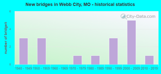
- New bridges - historical statistics
- 31940-1949
- 31950-1959
- 11970-1979
- 11980-1989
- 31990-1999
- 52000-2009
- 12010-2019

- Reconstructed bridges - Historical Statistics
- 31970-1979
- 11980-1989


- Bridge Condition - Deck
- 22.2%Very good
- 55.6%Good
- 11.1%Fair
- 11.1%Poor

- Bridge Condition - Superstructure
- 22.2%Very good
- 55.6%Good
- 11.1%Satisfactory
- 11.1%Fair

- Bridge Condition - Substructure
- 33.3%Excellent
- 22.2%Very good
- 11.1%Good
- 11.1%Satisfactory
- 22.2%Fair

- Bridge Condition - Channel
- 9.1%Excellent
- 27.3%Very good
- 9.1%Good
- 36.4%Satisfactory
- 18.2%Fair

- Bridge Condition - Culverts
- 16.7%Very good
- 16.7%Good
- 16.7%Satisfactory
- 50.0%Fair
Find on map >> Show street view
Structure Number: 22496, Location: S 2 T 28 N R 33 W (Lat: 37.175169, Lng: -94.491406), Route carried "on" structure: County highway 359, Year Built: 1992, Status: Open, Structure Length: 0.76m (2.49ft), Average Daily Traffic: 200 (year 2021), Truck Traffic: 10%, Average Future Daily Traffic: 300 (year 2041), Features Intersected: TRIB TO CENTER CR, Facility Carried by Structure: COUNTY RD 240
Minimum Vertical Clearance: 30+ m (98+ ft), Kilometerpoint: 0.966, Lanes on structure: 2, Owner: County Highway Agency, Approaching Roadway Width: 7.3m (24.0ft), Material/Design: Concrete, Design/Construction: Culvert, Number Of Spans In Main Unit: 2, Length of Maximum Span: 3.7m (12.1ft), Curb-To-Curb Width: 8.5m (27.9ft), Out-to-Out Width: 9.1m (29.9ft)
Condition: Channel: Very good, Culverts: Very good, Operating Rating: 31.5 metric tons, Method Used To Determine Operating Rating: Allowable Stress (AS), Inventory Rating: 25.2 metric tons, Method Used To Determine Inventory Rating: Allowable Stress (AS), Structural Evaluation: Equal to present minimum criteria, Deck Geometry: Equal to present minimum criteria, Waterway Adequacy: Equal to present desirable criteria, Approach Roadway Alignment: Equal to present desirable criteria, Designated Inspection Frequency: Every 24 months, Inspection Date: January 2021, Wearing Surface/Protective System: Wearing Surface: Bituminous
Find on map >> Show street view
Structure Number: 225, Location: S 2 T 28 N R 33 W (Lat: 37.172917, Lng: -94.491500), Route carried "on" structure: County highway 359, Year Built: 1992, Status: Open, Structure Length: 8.26m (27.10ft), Average Daily Traffic: 200 (year 2021), Truck Traffic: 10%, Average Future Daily Traffic: 300 (year 2041), Design Load: HS 20, Features Intersected: CENTER CR, Facility Carried by Structure: COUNTY RD 240
Minimum Vertical Clearance: 30+ m (98+ ft), Kilometerpoint: 1.448, Lanes on structure: 2, Owner: County Highway Agency, Approaching Roadway Width: 7.3m (24.0ft), Skew: 3 degrees, Material/Design: Prestressed concrete, Design/Construction: Stringer/Multi-beam, Number Of Spans In Main Unit: 3, Length of Maximum Span: 27.4m (89.9ft), Curb-To-Curb Width: 7.3m (24.0ft), Out-to-Out Width: 8.1m (26.6ft)
Condition: Deck: Good, Superstructure: Very good, Substructure: Good, Channel: Very good, Operating Rating: 54.0 metric tons, Method Used To Determine Operating Rating: Allowable Stress (AS), Inventory Rating: 32.4 metric tons, Method Used To Determine Inventory Rating: Allowable Stress (AS), Structural Evaluation: Better than present minimum criteria, Deck Geometry: Somewhat better than minimum adequacy, Waterway Adequacy: Equal to present desirable criteria, Approach Roadway Alignment: Equal to present minimum criteria, Designated Inspection Frequency: Every 24 months, Inspection Date: January 2021, Deck Structure Type: Concrete Cast-file-Place, Wearing Surface/Protective System: Wearing Surface: Monolithic Concrete
Find on map >> Show street view
Structure Number: 24008, Location: S 13 T 28 N R 33 W (Lat: 37.146106, Lng: -94.485725), Route carried "on" structure: City street , Year Built: 1955, Status: Open, Structure Length: 0.67m (2.20ft), Average Daily Traffic: 600 (year 2021), Truck Traffic: 10%, Average Future Daily Traffic: 900 (year 2041), Design Load: H 20, Features Intersected: BR OF CENTER CR, Facility Carried by Structure: BROADWAY ST
Minimum Vertical Clearance: 30+ m (98+ ft), Kilometerpoint: 0.161, Lanes on structure: 2, Owner: City or Municipal Highway Agency, Approaching Roadway Width: 6.7m (22.0ft), Material/Design: Concrete, Design/Construction: Tee Beam, Number Of Spans In Main Unit: 1, Length of Maximum Span: 6.1m (20.0ft), Curb-To-Curb Width: 8.6m (28.2ft), Out-to-Out Width: 9.2m (30.2ft)
Condition: Deck: Good, Superstructure: Good, Substructure: Fair, Channel: Fair, Operating Rating: 49.5 metric tons, Method Used To Determine Operating Rating: Allowable Stress (AS), Inventory Rating: 16.2 metric tons, Method Used To Determine Inventory Rating: Allowable Stress (AS), Structural Evaluation: Meets minimum limits, Deck Geometry: Somewhat better than minimum adequacy, Waterway Adequacy: Equal to present desirable criteria, Approach Roadway Alignment: Equal to present desirable criteria, Designated Inspection Frequency: Every 24 months, Inspection Date: January 2021, Deck Structure Type: Concrete Cast-file-Place, Wearing Surface/Protective System: Wearing Surface: Bituminous
Find on map >> Show street view
Structure Number: 24009, Location: S 17 T 28 N R 32 W (Lat: 37.147586, Lng: -94.452892), Route carried "on" structure: City street , Year Built: 1988, Status: Open, Structure Length: 1.01m (3.31ft), Average Daily Traffic: 3,800 (year 2021), Truck Traffic: 10%, Average Future Daily Traffic: 5,700 (year 2041), Design Load: H 10, Features Intersected: MINE CR, Facility Carried by Structure: BROADWY/DAUGHERTY
Minimum Vertical Clearance: 30+ m (98+ ft), Kilometerpoint: 0.322, Lanes on structure: 2, Owner: City or Municipal Highway Agency, Approaching Roadway Width: 7.0m (23.0ft), Material/Design: Concrete, Design/Construction: Slab, Number Of Spans In Main Unit: 2, Length of Maximum Span: 4.9m (16.1ft), Curb or Sidewalk Widths: Left: 0.2m (0.7ft), Right: 1.9m (6.2ft), Curb-To-Curb Width: 8.5m (27.9ft), Out-to-Out Width: 9.4m (30.8ft)
Condition: Deck: Very good, Superstructure: Very good, Substructure: Very good, Channel: Satisfactory, Operating Rating: 49.5 metric tons, Method Used To Determine Operating Rating: Allowable Stress (AS), Inventory Rating: 32.4 metric tons, Method Used To Determine Inventory Rating: Allowable Stress (AS), Structural Evaluation: Equal to present desirable criteria, Deck Geometry: Meets minimum limits, Waterway Adequacy: Equal to present desirable criteria, Approach Roadway Alignment: Equal to present desirable criteria, Designated Inspection Frequency: Every 24 months, Inspection Date: January 2021, Deck Structure Type: Concrete Cast-file-Place, Wearing Surface/Protective System: Wearing Surface: Bituminous
Find on map >> Show street view
Structure Number: 2401, Location: S 10 T 41 N R 15 W (Lat: 38.319872, Lng: -92.575189), Route carried "on" structure: US 54, Year Built: 1973, Status: Open, Structure Length: 1.31m (4.30ft), Average Daily Traffic: 12,358 (year 2021), Truck Traffic: 13%, Average Future Daily Traffic: 21,627 (year 2041), Design Load: HS 20, Features Intersected: SALINE CR
Minimum Vertical Clearance: 30+ m (98+ ft), Kilometerpoint: 221.240, Lanes on structure: 4, Base Highway Network: Yes, Owner: State Highway Agency, Approaching Roadway Width: 12.2m (40.0ft), Skew: 23 degrees, Material/Design: Concrete continuous, Design/Construction: Culvert, Number Of Spans In Main Unit: 3, Length of Maximum Span: 3.7m (12.1ft)
Condition: Channel: Fair, Culverts: Fair, Operating Rating: 87.3 metric tons, Method Used To Determine Operating Rating: Field evaluation and documented engineering judgment, Inventory Rating: 52.2 metric tons, Method Used To Determine Inventory Rating: Field evaluation and documented engineering judgment, Structural Evaluation: Somewhat better than minimum adequacy, Waterway Adequacy: Equal to present desirable criteria, Approach Roadway Alignment: Equal to present desirable criteria, Designated Inspection Frequency: Every 24 months, Inspection Date: November 2020
Find on map >> Show street view
Structure Number: 2401, Location: S 13 T 28 N R 33 W (Lat: 37.145533, Lng: -94.483694), Route carried "on" structure: City street , Year Built: 1950, Status: Open, Structure Length: 0.67m (2.20ft), Average Daily Traffic: 2,600 (year 2021), Truck Traffic: 10%, Average Future Daily Traffic: 3,900 (year 2041), Features Intersected: BR OF CENTER CR, Facility Carried by Structure: POWELL DR
Minimum Vertical Clearance: 30+ m (98+ ft), Kilometerpoint: 0.483, Lanes on structure: 2, Owner: City or Municipal Highway Agency, Approaching Roadway Width: 7.0m (23.0ft), Skew: 2 degrees, Material/Design: Concrete, Design/Construction: Culvert, Number Of Spans In Main Unit: 2, Length of Maximum Span: 3.4m (11.2ft), Curb-To-Curb Width: 10.2m (33.5ft), Out-to-Out Width: 11.0m (36.1ft)
Condition: Channel: Good, Culverts: Fair, Operating Rating: 49.5 metric tons, Method Used To Determine Operating Rating: Allowable Stress (AS), Inventory Rating: 16.2 metric tons, Method Used To Determine Inventory Rating: Allowable Stress (AS), Structural Evaluation: Meets minimum limits, Deck Geometry: Meets minimum limits, Waterway Adequacy: Equal to present minimum criteria, Approach Roadway Alignment: Equal to present desirable criteria, Designated Inspection Frequency: Every 24 months, Inspection Date: January 2021
Find on map >> Show street view
Structure Number: 2436, Location: S 5 T 28 N R 32 W (Lat: 37.170261, Lng: -94.449694), Route carried "on" structure: County highway 483, Year Built: 1990, Status: Open, Structure Length: 3.14m (10.30ft), Average Daily Traffic: 200 (year 2021), Truck Traffic: 10%, Average Future Daily Traffic: 300 (year 2041), Design Load: HS 20, Features Intersected: TRIB TO CENTER CR, Facility Carried by Structure: HAWTHORNE RD
Minimum Vertical Clearance: 30+ m (98+ ft), Kilometerpoint: 0.483, Lanes on structure: 2, Owner: County Highway Agency, Approaching Roadway Width: 6.1m (20.0ft), Skew: 1 degrees, Material/Design: Prestressed concrete, Design/Construction: Tee Beam, Number Of Spans In Main Unit: 3, Length of Maximum Span: 11.6m (38.1ft), Curb-To-Curb Width: 7.3m (24.0ft), Out-to-Out Width: 8.2m (26.9ft)
Condition: Deck: Good, Superstructure: Good, Substructure: Very good, Channel: Very good, Operating Rating: 58.5 metric tons, Method Used To Determine Operating Rating: Allowable Stress (AS), Inventory Rating: 32.4 metric tons, Method Used To Determine Inventory Rating: Allowable Stress (AS), Structural Evaluation: Better than present minimum criteria, Deck Geometry: Somewhat better than minimum adequacy, Waterway Adequacy: Equal to present desirable criteria, Approach Roadway Alignment: Equal to present desirable criteria, Designated Inspection Frequency: Every 24 months, Inspection Date: January 2021, Deck Structure Type: Concrete Cast-file-Place, Wearing Surface/Protective System: Wearing Surface: Monolithic Concrete
Find on map >> Show street view
Structure Number: 31408, Location: S 20 T 28 N R 32 W (Lat: 37.126764, Lng: -94.441439), Route carried "on" structure: State highway 249, Year Built: 2006, Status: Open, Structure Length: 4.06m (13.32ft), Average Daily Traffic: 8,060 (year 2021), Truck Traffic: 19%, Average Future Daily Traffic: 14,508 (year 2041), Design Load: HS 25 or greater, Features Intersected: CRD E FOUNTAIN RD
Minimum Vertical Clearance: 30+ m (98+ ft), Kilometerpoint: 8.101, Lanes on structure: 2, Lanes under structure: 2, Base Highway Network: Yes, Owner: State Highway Agency, Approaching Roadway Width: 11.4m (37.4ft), Material/Design: Prestressed concrete continuous, Design/Construction: Stringer/Multi-beam, Number Of Spans In Main Unit: 3, Length of Maximum Span: 17.5m (57.4ft), Curb-To-Curb Width: 11.4m (37.4ft), Out-to-Out Width: 12.2m (40.0ft)
Condition: Deck: Good, Superstructure: Good, Substructure: Excellent, Operating Rating: 81.9 metric tons, Method Used To Determine Operating Rating: Load Factor (LF), Inventory Rating: 48.6 metric tons, Method Used To Determine Inventory Rating: Load Factor (LF), Structural Evaluation: Better than present minimum criteria, Deck Geometry: Somewhat better than minimum adequacy, Underclear: Equal to present minimum criteria, Approach Roadway Alignment: Equal to present desirable criteria, Designated Inspection Frequency: Every 24 months, Inspection Date: August 2021, Deck Structure Type: Concrete Cast-file-Place, Wearing Surface/Protective System: Wearing Surface: Monolithic Concrete, Deck Protection: Epoxy Coated Reinforcing
Find on map >> Show street view
Structure Number: 31596, Location: S 20 T 28 N R 32 W (Lat: 37.126781, Lng: -94.441747), Route carried "on" structure: State highway 249, Year Built: 2006, Status: Open, Structure Length: 4.06m (13.32ft), Average Daily Traffic: 9,579 (year 2021), Truck Traffic: 20%, Average Future Daily Traffic: 17,242 (year 2041), Design Load: HS 25 or greater, Features Intersected: CRD E FOUNTAIN RD
Minimum Vertical Clearance: 30+ m (98+ ft), Kilometerpoint: 1.914, Lanes on structure: 2, Lanes under structure: 2, Base Highway Network: Yes, Owner: State Highway Agency, Approaching Roadway Width: 11.6m (38.1ft), Material/Design: Prestressed concrete continuous, Design/Construction: Stringer/Multi-beam, Number Of Spans In Main Unit: 3, Length of Maximum Span: 17.4m (57.1ft), Curb-To-Curb Width: 11.6m (38.1ft), Out-to-Out Width: 12.4m (40.7ft)
Condition: Deck: Good, Superstructure: Good, Substructure: Excellent, Operating Rating: 90.0 metric tons, Method Used To Determine Operating Rating: Load Factor (LF), Inventory Rating: 46.8 metric tons, Method Used To Determine Inventory Rating: Load Factor (LF), Structural Evaluation: Better than present minimum criteria, Deck Geometry: Equal to present minimum criteria, Underclear: Equal to present minimum criteria, Approach Roadway Alignment: Equal to present desirable criteria, Designated Inspection Frequency: Every 24 months, Inspection Date: August 2021, Deck Structure Type: Concrete Cast-file-Place, Wearing Surface/Protective System: Wearing Surface: Monolithic Concrete, Deck Protection: Epoxy Coated Reinforcing
Find on map >> Show street view
Structure Number: 31976, Location: S 13 T 28 N R 33 W (Lat: 37.145097, Lng: -94.482167), Route carried "on" structure: County highway 450, Year Built: 2005, Status: Open, Structure Length: 0.82m (2.69ft), Average Daily Traffic: 1,000 (year 2021), Truck Traffic: 10%, Average Future Daily Traffic: 1,500 (year 2041), Design Load: HS 20, Features Intersected: SUNSET CR, Facility Carried by Structure: COLLEGE DR
Minimum Vertical Clearance: 30+ m (98+ ft), Kilometerpoint: 0.644, Lanes on structure: 2, Owner: County Highway Agency, Approaching Roadway Width: 9.1m (29.9ft), Skew: 2 degrees, Material/Design: Concrete, Design/Construction: Culvert, Number Of Spans In Main Unit: 1, Length of Maximum Span: 8.1m (26.6ft), Curb-To-Curb Width: 9.1m (29.9ft), Out-to-Out Width: 13.8m (45.3ft)
Condition: Channel: Excellent, Culverts: Good, Operating Rating: 54.0 metric tons, Method Used To Determine Operating Rating: Field evaluation and documented engineering judgment, Inventory Rating: 32.4 metric tons, Method Used To Determine Inventory Rating: Field evaluation and documented engineering judgment, Structural Evaluation: Better than present minimum criteria, Deck Geometry: Equal to present minimum criteria, Waterway Adequacy: Equal to present desirable criteria, Approach Roadway Alignment: Equal to present desirable criteria, Designated Inspection Frequency: Every 24 months, Inspection Date: January 2021, Wearing Surface/Protective System: Wearing Surface: Bituminous
Find on map >> Show street view
Structure Number: 33754, Location: S 11 T 28 N R 32 W (Lat: 37.165242, Lng: -94.401183), Route carried "on" structure: State highway 171, Year Built: 2012, Status: Open, Structure Length: 8.69m (28.51ft), Average Daily Traffic: 8,272 (year 2021), Truck Traffic: 17%, Average Future Daily Traffic: 14,890 (year 2041), Features Intersected: MNA RR
Minimum Vertical Clearance: 30+ m (98+ ft), Kilometerpoint: 6.611, Lanes on structure: 2, Base Highway Network: Yes, Owner: State Highway Agency, Approaching Roadway Width: 12.2m (40.0ft), Material/Design: Steel continuous, Design/Construction: Stringer/Multi-beam, Number Of Spans In Main Unit: 3, Length of Maximum Span: 33.5m (109.9ft), Curb-To-Curb Width: 11.6m (38.1ft), Out-to-Out Width: 12.4m (40.7ft)
Condition: Deck: Very good, Superstructure: Good, Substructure: Excellent, Operating Rating: 78.3 metric tons, Method Used To Determine Operating Rating: Load Factor (LF), Inventory Rating: 46.8 metric tons, Method Used To Determine Inventory Rating: Load Factor (LF), Structural Evaluation: Better than present minimum criteria, Deck Geometry: Better than present minimum criteria, Underclear: Equal to present desirable criteria, Approach Roadway Alignment: Equal to present desirable criteria, Designated Inspection Frequency: Every 24 months, Inspection Date: August 2021, Deck Structure Type: Concrete Cast-file-Place, Wearing Surface/Protective System: Wearing Surface: Monolithic Concrete, Deck Protection: Epoxy Coated Reinforcing
Find on map >> Show street view
Structure Number: 6181, Location: S 17 T 28 N R 32 W (Lat: 37.141586, Lng: -94.453722), Route carried "on" structure: State highway 171, Year Built: 1949, Year Reconstructed: 1977, Status: Open, Structure Length: 7.47m (24.51ft), Average Daily Traffic: 7,076 (year 2021), Truck Traffic: 11%, Average Future Daily Traffic: 10,968 (year 2041), Design Load: H 20, Features Intersected: MNA RR
Minimum Vertical Clearance: 30+ m (98+ ft), Kilometerpoint: 29.401, Lanes on structure: 2, Base Highway Network: Yes, Owner: State Highway Agency, Approaching Roadway Width: 7.3m (24.0ft), Material/Design: Steel continuous, Design/Construction: Stringer/Multi-beam, Number Of Spans In Main Unit: 4, Length of Maximum Span: 20.9m (68.6ft), Curb or Sidewalk Widths: Left: 0.5m (1.6ft), Right: 0.5m (1.6ft), Curb-To-Curb Width: 8.5m (27.9ft), Out-to-Out Width: 9.7m (31.8ft)
Condition: Deck: Poor, Superstructure: Fair, Substructure: Satisfactory, Operating Rating: 35.1 metric tons, Method Used To Determine Operating Rating: Load Factor (LF), Inventory Rating: 21.6 metric tons, Method Used To Determine Inventory Rating: Load Factor (LF), Structural Evaluation: Somewhat better than minimum adequacy, Deck Geometry: High priority of corrective action, Underclear: Meets minimum limits, Approach Roadway Alignment: Equal to present desirable criteria, Length Of Structure Improvement: 0.85m (2.79ft), Designated Inspection Frequency: Every 24 months, Inspection Date: August 2021, Bridge Improvement Cost: $1,021,000, Roadway Improvement Cost: $102,000, Total Project Cost: $1,531,000 ( Estimate for 2022), Deck Structure Type: Concrete Cast-file-Place, Wearing Surface/Protective System: Wearing Surface: Bituminous
Find on map >> Show street view
Structure Number: 6184, Location: S 17 T 28 N R 32 W (Lat: 37.141522, Lng: -94.449542), Route carried "on" structure: State highway 171, Year Built: 1949, Year Reconstructed: 1977, Status: Open, Structure Length: 1.07m (3.51ft), Average Daily Traffic: 12,477 (year 2021), Truck Traffic: 11%, Average Future Daily Traffic: 19,339 (year 2041), Design Load: HS 20, Features Intersected: MINE BR
Minimum Vertical Clearance: 30+ m (98+ ft), Kilometerpoint: 29.845, Lanes on structure: 4, Base Highway Network: Yes, Owner: State Highway Agency, Approaching Roadway Width: 39.0m (128.0ft), Skew: 24 degrees, Material/Design: Concrete continuous, Design/Construction: Culvert, Number Of Spans In Main Unit: 2, Length of Maximum Span: 3.7m (12.1ft)
Condition: Channel: Satisfactory, Culverts: Fair, Operating Rating: 38.7 metric tons, Method Used To Determine Operating Rating: Load Factor (LF), Inventory Rating: 22.5 metric tons, Method Used To Determine Inventory Rating: Load Factor (LF), Structural Evaluation: Somewhat better than minimum adequacy, Waterway Adequacy: Equal to present desirable criteria, Approach Roadway Alignment: Equal to present desirable criteria, Designated Inspection Frequency: Every 24 months, Inspection Date: January 2022
Find on map >> Show street view
Structure Number: 6185, Location: S 10 T 28 N R 32 W (Lat: 37.162300, Lng: -94.409156), Route carried "on" structure: State highway 171, Year Built: 1949, Year Reconstructed: 1981, Status: Open, Structure Length: 11.70m (38.39ft), Average Daily Traffic: 8,272 (year 2021), Truck Traffic: 17%, Average Future Daily Traffic: 14,890 (year 2041), Design Load: H 20, Features Intersected: CENTER CR
Minimum Vertical Clearance: 30+ m (98+ ft), Kilometerpoint: 7.374, Lanes on structure: 2, Base Highway Network: Yes, Owner: State Highway Agency, Approaching Roadway Width: 12.2m (40.0ft), Skew: 2 degrees, Material/Design: Steel continuous, Design/Construction: Stringer/Multi-beam, Number Of Spans In Main Unit: 7, Length of Maximum Span: 24.4m (80.1ft), Curb or Sidewalk Widths: Left: 0.4m (1.3ft), Right: 0.4m (1.3ft), Curb-To-Curb Width: 8.5m (27.9ft), Out-to-Out Width: 9.7m (31.8ft)
Condition: Deck: Fair, Superstructure: Satisfactory, Substructure: Fair, Channel: Satisfactory, Operating Rating: 36.0 metric tons, Method Used To Determine Operating Rating: Load Factor (LF), Inventory Rating: 21.6 metric tons, Method Used To Determine Inventory Rating: Load Factor (LF), Structural Evaluation: Somewhat better than minimum adequacy, Deck Geometry: High priority of corrective action, Waterway Adequacy: Equal to present minimum criteria, Approach Roadway Alignment: Equal to present desirable criteria, Length Of Structure Improvement: 1.26m (4.13ft), Designated Inspection Frequency: Every 24 months, Underwater Inspection Frequency: Every 60 months, Inspection Date: August 2021, Underwater Inspection Date: June 2021, Bridge Improvement Cost: $1,511,000, Roadway Improvement Cost: $151,000, Total Project Cost: $2,267,000 ( Estimate for 2022), Deck Structure Type: Concrete Cast-file-Place, Wearing Surface/Protective System: Wearing Surface: Bituminous
Find on map >> Show street view
Structure Number: 6269, Location: S 13 T 28 N R 33 W (Lat: 37.141992, Lng: -94.487425), Route carried "on" structure: State highway 171, Year Built: 1954, Year Reconstructed: 1985, Status: Open, Structure Length: 0.76m (2.49ft), Average Daily Traffic: 15,891 (year 2021), Truck Traffic: 5%, Average Future Daily Traffic: 24,631 (year 2041), Design Load: H 20, Features Intersected: WEBB BR
Minimum Vertical Clearance: 30+ m (98+ ft), Kilometerpoint: 26.453, Lanes on structure: 4, Base Highway Network: Yes, Owner: State Highway Agency, Approaching Roadway Width: 13.4m (44.0ft), Material/Design: Concrete continuous, Design/Construction: Culvert, Number Of Spans In Main Unit: 2, Length of Maximum Span: 3.7m (12.1ft)
Condition: Channel: Satisfactory, Culverts: Satisfactory, Operating Rating: 72.0 metric tons, Method Used To Determine Operating Rating: Field evaluation and documented engineering judgment, Inventory Rating: 43.2 metric tons, Method Used To Determine Inventory Rating: Field evaluation and documented engineering judgment, Structural Evaluation: Equal to present minimum criteria, Waterway Adequacy: Equal to present desirable criteria, Approach Roadway Alignment: Equal to present desirable criteria, Designated Inspection Frequency: Every 24 months, Inspection Date: January 2022
Find on map >> Show street view
Structure Number: 31408, Location: S 20 T 28 N R 32 W (Lat: 37.126764, Lng: -94.441439), Route carried "under" structure: County highway , Year Built: 2006, Structure Length: 0. m, Average Daily Traffic: 210 (year 2021), Truck Traffic: 10%, Features Intersected: CRD E FOUNTAIN RD, Facility Carried by Structure: MO 249 N
Minimum Vertical Clearance: 4.42m (14.50ft), Kilometerpoint: 2.200, Lanes on structure: 2, Lanes under structure: 2, Material/Design: Prestressed concrete continuous, Design/Construction: Stringer/Multi-beam, Length of Maximum Span: 17.5m (57.4ft)
Find on map >> Show street view
Structure Number: 31596, Location: S 20 T 28 N R 32 W (Lat: 37.126781, Lng: -94.441747), Route carried "under" structure: County highway , Year Built: 2006, Structure Length: 0. m, Average Daily Traffic: 210 (year 2021), Truck Traffic: 10%, Features Intersected: CRD E FOUNTAIN RD, Facility Carried by Structure: MO 249 S
Minimum Vertical Clearance: 4.70m (15.42ft), Kilometerpoint: 2.210, Lanes on structure: 2, Lanes under structure: 2, Material/Design: Prestressed concrete continuous, Design/Construction: Stringer/Multi-beam, Length of Maximum Span: 17.4m (57.1ft)