Bridge Statistics for Waterville, Maine (ME)
Condition, Traffic, Stress, Structural Evaluation, Project Costs
- National Bridge Inventory (NBI) Statistics
- 25Number of bridges
- 810ft / 247mTotal length
- 217,752Total average daily traffic
- 16,312Total average daily truck traffic
- National Bridge Inventory (NBI) Registered Bridges for Waterville
- No street view available for this location
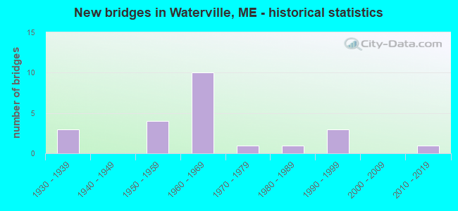
- New bridges - historical statistics
- 31930-1939
- 41950-1959
- 101960-1969
- 11970-1979
- 11980-1989
- 31990-1999
- 12010-2019
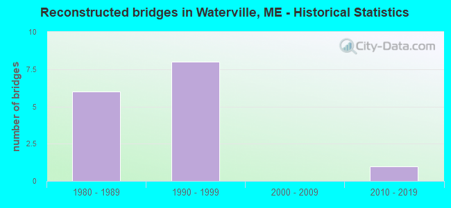
- Reconstructed bridges - Historical Statistics
- 61980-1989
- 81990-1999
- 02000-2009
- 12010-2019
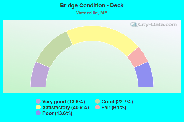
- Bridge Condition - Deck
- 13.6%Very good
- 22.7%Good
- 40.9%Satisfactory
- 9.1%Fair
- 13.6%Poor
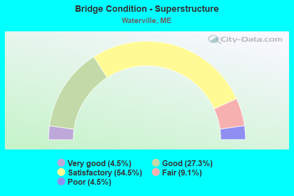
- Bridge Condition - Superstructure
- 4.5%Very good
- 27.3%Good
- 54.5%Satisfactory
- 9.1%Fair
- 4.5%Poor
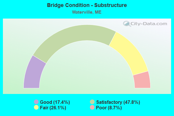
- Bridge Condition - Substructure
- 17.4%Good
- 47.8%Satisfactory
- 26.1%Fair
- 8.7%Poor
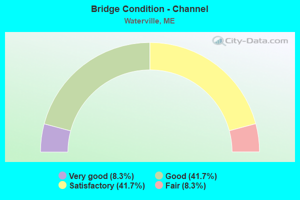
- Bridge Condition - Channel
- 8.3%Very good
- 41.7%Good
- 41.7%Satisfactory
- 8.3%Fair
Find on map >> Show street view
Structure Number: 1141, Location: 0.2 MI W'LY OF RTE 201 (Lat: 44.530719, Lng: -69.646581), Route carried "on" structure: State highway 137, Year Built: 1997, Status: Open, Structure Length: 61.72m (202.49ft), Average Daily Traffic: 11,790 (year 2016), Truck Traffic: 5%, Average Future Daily Traffic: 16,506 (year 2036), Design Load: HS 25 or greater, Features Intersected: KENNEBEC R, H2O ST, & RR
Minimum Vertical Clearance: 30+ m (98+ ft), Kilometerpoint: 60.173, Lanes on structure: 2, Lanes under structure: 2, Base Highway Network: Yes, Owner: State Highway Agency, Approaching Roadway Width: 14.6m (47.9ft), Material/Design: Steel continuous, Design/Construction: Stringer/Multi-beam, Number Of Spans In Main Unit: 13, Length of Maximum Span: 73.2m (240.2ft), Curb or Sidewalk Widths: Left: 0.2m (0.7ft), Right: 0.2m (0.7ft), Curb-To-Curb Width: 14.6m (47.9ft), Out-to-Out Width: 15.4m (50.5ft)
Condition: Deck: Very good, Superstructure: Good, Substructure: Good, Channel: Good, Operating Rating: 44.1 metric tons, Method Used To Determine Operating Rating: Load and Resistance Factor Rating (LRFR) rating reported by rating factor(RF) method using HL-93 loadings, Inventory Rating: 34.0 metric tons, Method Used To Determine Inventory Rating: Load and Resistance Factor Rating (LRFR) rating reported by rating factor(RF) method using HL-93 loadings, Structural Evaluation: Better than present minimum criteria, Deck Geometry: Superior to present desirable criteria, Underclear: Somewhat better than minimum adequacy, Waterway Adequacy: Superior to present desirable criteria, Approach Roadway Alignment: Better than present minimum criteria, Designated Inspection Frequency: Every 24 months, Underwater Inspection Frequency: Every 60 months, Inspection Date: March 2021, Underwater Inspection Date: September 2019, Deck Structure Type: Concrete Precast Panels, Wearing Surface/Protective System: Wearing Surface: Bituminous, Membrane: Preformed Fabric
Find on map >> Show street view
Structure Number: 1457, Location: 0.8 MI S TOWNLINE (Lat: 44.572031, Lng: -69.641011), Route carried "on" structure: State highway 95, Year Built: 1960, Year Reconstructed: 2003, Status: Open, Structure Length: 5.03m (16.50ft), Average Daily Traffic: 10,860 (year 2016), Truck Traffic: 10%, Average Future Daily Traffic: 15,204 (year 2036), Design Load: HS 20+Mod, Features Intersected: ROUTE 104
Minimum Vertical Clearance: 30+ m (98+ ft), Kilometerpoint: 280.460, Lanes on structure: 2, Lanes under structure: 3, Base Highway Network: Yes, Owner: State Highway Agency, Approaching Roadway Width: 12.2m (40.0ft), Skew: 1 degrees, Material/Design: Steel, Design/Construction: Stringer/Multi-beam, Number Of Spans In Main Unit: 3, Length of Maximum Span: 18.9m (62.0ft), Curb or Sidewalk Widths: Left: 0.1m (0.3ft), Right: 0.1m (0.3ft), Curb-To-Curb Width: 10.1m (33.1ft), Out-to-Out Width: 10.8m (35.4ft)
Condition: Deck: Good, Superstructure: Satisfactory, Substructure: Satisfactory, Channel: Satisfactory, Operating Rating: 71.0 metric tons, Method Used To Determine Operating Rating: Load and Resistance Factor Rating (LRFR) rating reported by rating factor(RF) method using HL-93 loadings, Inventory Rating: 54.8 metric tons, Method Used To Determine Inventory Rating: Load and Resistance Factor Rating (LRFR) rating reported by rating factor(RF) method using HL-93 loadings, Structural Evaluation: Equal to present minimum criteria, Deck Geometry: High priority of corrective action, Underclear: High priority of corrective action, Approach Roadway Alignment: Equal to present desirable criteria, Designated Inspection Frequency: Every 24 months, Inspection Date: August 2020, Deck Structure Type: Concrete Cast-file-Place, Wearing Surface/Protective System: Wearing Surface: Bituminous, Membrane: Preformed Fabric
Find on map >> Show street view
Structure Number: 1458, Location: 0.2 MI S JCT RTE 104 (Lat: 44.571750, Lng: -69.653669), Route carried "on" structure: State highway 95, Year Built: 1960, Year Reconstructed: 2003, Status: Open, Structure Length: 31.21m (102.40ft), Average Daily Traffic: 17,030 (year 2016), Truck Traffic: 10%, Average Future Daily Traffic: 23,842 (year 2036), Design Load: HS 20+Mod, Features Intersected: MESSALONSKEE STREAM
Minimum Vertical Clearance: 30+ m (98+ ft), Kilometerpoint: 281.426, Lanes on structure: 2, Base Highway Network: Yes, Owner: State Highway Agency, Approaching Roadway Width: 11.9m (39.0ft), Material/Design: Steel continuous, Design/Construction: Girder and Floorbeam System, Number Of Spans In Main Unit: 3, Number Of Approach Spans: 7, Length of Maximum Span: 41.5m (136.2ft), Curb or Sidewalk Widths: Left: 0.1m (0.3ft), Right: 0.1m (0.3ft), Curb-To-Curb Width: 10.1m (33.1ft), Out-to-Out Width: 10.8m (35.4ft)
Condition: Deck: Good, Superstructure: Satisfactory, Substructure: Satisfactory, Channel: Satisfactory, Operating Rating: 48.9 metric tons, Method Used To Determine Operating Rating: Load and Resistance Factor Rating (LRFR) rating reported by rating factor(RF) method using HL-93 loadings, Inventory Rating: 37.6 metric tons, Method Used To Determine Inventory Rating: Load and Resistance Factor Rating (LRFR) rating reported by rating factor(RF) method using HL-93 loadings, Structural Evaluation: Equal to present minimum criteria, Deck Geometry: Meets minimum limits, Waterway Adequacy: Superior to present desirable criteria, Approach Roadway Alignment: Better than present minimum criteria, Designated Inspection Frequency: Every 24 months, Critical Feature Inspection Frequency: Every 24 months, Underwater Inspection Frequency: Every 60 months, Inspection Date: September 2021, Critical Feature Inspection Date: September 2021, Underwater Inspection Date: August 2018, Deck Structure Type: Concrete Cast-file-Place, Wearing Surface/Protective System: Wearing Surface: Bituminous, Membrane: Preformed Fabric
Find on map >> Show street view
Structure Number: 1459, Location: 0.8 MI S JCT RTEb 104 (Lat: 44.571711, Lng: -69.656361), Route carried "on" structure: State highway 95, Year Built: 1960, Year Reconstructed: 2003, Status: Open, Structure Length: 8.01m (26.28ft), Average Daily Traffic: 15,170 (year 2016), Truck Traffic: 10%, Average Future Daily Traffic: 23,842 (year 2036), Design Load: HS 20+Mod, Features Intersected: COUNTY ROAD & M C RR
Minimum Vertical Clearance: 30+ m (98+ ft), Kilometerpoint: 281.701, Lanes on structure: 2, Lanes under structure: 2, Base Highway Network: Yes, Owner: State Highway Agency, Approaching Roadway Width: 12.5m (41.0ft), Skew: 2 degrees, Material/Design: Steel continuous, Design/Construction: Stringer/Multi-beam, Number Of Spans In Main Unit: 4, Length of Maximum Span: 20.7m (67.9ft), Curb or Sidewalk Widths: Left: 0.1m (0.3ft), Right: 0.1m (0.3ft), Curb-To-Curb Width: 10.1m (33.1ft), Out-to-Out Width: 10.9m (35.8ft)
Condition: Deck: Satisfactory, Superstructure: Satisfactory, Substructure: Satisfactory, Operating Rating: 82.9 metric tons, Method Used To Determine Operating Rating: Load and Resistance Factor Rating (LRFR) rating reported by rating factor(RF) method using HL-93 loadings, Inventory Rating: 63.8 metric tons, Method Used To Determine Inventory Rating: Load and Resistance Factor Rating (LRFR) rating reported by rating factor(RF) method using HL-93 loadings, Structural Evaluation: Equal to present minimum criteria, Deck Geometry: Meets minimum limits, Underclear: Equal to present desirable criteria, Approach Roadway Alignment: Better than present minimum criteria, Designated Inspection Frequency: Every 24 months, Inspection Date: April 2021, Deck Structure Type: Concrete Cast-file-Place, Wearing Surface/Protective System: Wearing Surface: Bituminous, Membrane: Built-up
Find on map >> Show street view
Structure Number: 146, Location: I-95 INTERCHANGE # 127 (Lat: 44.545061, Lng: -69.680250), Route carried "on" structure: State highway 95, Year Built: 1960, Year Reconstructed: 1989, Status: Open, Structure Length: 6.71m (22.01ft), Average Daily Traffic: 13,100 (year 2016), Truck Traffic: 10%, Average Future Daily Traffic: 18,340 (year 2036), Design Load: HS 20+Mod, Features Intersected: ROUTE 11 & 137
Minimum Vertical Clearance: 30+ m (98+ ft), Kilometerpoint: 285.483, Lanes on structure: 2, Lanes under structure: 5, Base Highway Network: Yes, Owner: State Highway Agency, Approaching Roadway Width: 12.2m (40.0ft), Skew: 2 degrees, Material/Design: Steel, Design/Construction: Stringer/Multi-beam, Number Of Spans In Main Unit: 3, Length of Maximum Span: 29.9m (98.1ft), Curb-To-Curb Width: 12.9m (42.3ft), Out-to-Out Width: 14.4m (47.2ft)
Condition: Deck: Satisfactory, Superstructure: Satisfactory, Substructure: Satisfactory, Operating Rating: 56.7 metric tons, Method Used To Determine Operating Rating: Load and Resistance Factor Rating (LRFR) rating reported by rating factor(RF) method using HL-93 loadings, Inventory Rating: 43.7 metric tons, Method Used To Determine Inventory Rating: Load and Resistance Factor Rating (LRFR) rating reported by rating factor(RF) method using HL-93 loadings, Structural Evaluation: Equal to present minimum criteria, Deck Geometry: Superior to present desirable criteria, Underclear: High priority of corrective action, Approach Roadway Alignment: Equal to present desirable criteria, Designated Inspection Frequency: Every 24 months, Inspection Date: July 2020, Deck Structure Type: Concrete Cast-file-Place, Wearing Surface/Protective System: Wearing Surface: Bituminous, Membrane: Preformed Fabric
Find on map >> Show street view
Structure Number: 1461, Location: 1.4 MI N OF SIDNEY TL (Lat: 44.524850, Lng: -69.696511), Route carried "on" structure: State highway 95, Year Built: 1959, Year Reconstructed: 1989, Status: Open, Structure Length: 4.21m (13.81ft), Average Daily Traffic: 15,250 (year 2016), Truck Traffic: 5%, Average Future Daily Traffic: 21,350 (year 2036), Design Load: HS 20+Mod, Features Intersected: WEBB ROAD
Minimum Vertical Clearance: 30+ m (98+ ft), Kilometerpoint: 288.008, Lanes on structure: 2, Lanes under structure: 2, Base Highway Network: Yes, Owner: State Highway Agency, Approaching Roadway Width: 12.2m (40.0ft), Skew: 1 degrees, Material/Design: Steel, Design/Construction: Stringer/Multi-beam, Number Of Spans In Main Unit: 3, Length of Maximum Span: 13.1m (43.0ft), Curb or Sidewalk Widths: Left: 0.1m (0.3ft), Right: 0.1m (0.3ft), Curb-To-Curb Width: 12.3m (40.4ft), Out-to-Out Width: 12.9m (42.3ft)
Condition: Deck: Poor, Superstructure: Fair, Substructure: Poor, Operating Rating: 31.1 metric tons, Method Used To Determine Operating Rating: Load and Resistance Factor Rating (LRFR) rating reported by rating factor(RF) method using HL-93 loadings, Inventory Rating: 24.0 metric tons, Method Used To Determine Inventory Rating: Load and Resistance Factor Rating (LRFR) rating reported by rating factor(RF) method using HL-93 loadings, Structural Evaluation: Meets minimum limits, Deck Geometry: Better than present minimum criteria, Underclear: Meets minimum limits, Approach Roadway Alignment: Equal to present desirable criteria, Designated Inspection Frequency: Every 24 months, Inspection Date: August 2021, Deck Structure Type: Concrete Cast-file-Place, Wearing Surface/Protective System: Wearing Surface: Bituminous, Membrane: Preformed Fabric
Find on map >> Show street view
Structure Number: 1528, Location: .5 MI N RTE 104 (Lat: 44.558881, Lng: -69.628031), Year Built: 1963, Status: Open, Structure Length: 5.38m (17.65ft), Average Future Daily Traffic: 18,270 (year 2034), Design Load: HS 20, Features Intersected: RTE 201
Lanes under structure: 4, Owner: Railroad, Skew: 3 degrees, Material/Design: Steel, Design/Construction: Girder and Floorbeam System, Number Of Spans In Main Unit: 2, Length of Maximum Span: 25.3m (83.0ft), Out-to-Out Width: 5.5m (18.0ft)
Condition: Substructure: Fair, Underclear: High priority of corrective action, Designated Inspection Frequency: Every 24 months, Inspection Date: June 2021
Find on map >> Show street view
Structure Number: 2141, Location: 1.4 MI N JCT 104 (Lat: 44.566769, Lng: -69.650539), Route carried "on" structure: County highway , Year Built: 1981, Status: Open, Structure Length: 2.93m (9.61ft), Average Daily Traffic: 6,073 (year 2016), Truck Traffic: 5%, Average Future Daily Traffic: 8,502 (year 2036), Design Load: H 20, Features Intersected: MESSALONSKEE STREAM, Facility Carried by Structure: NORTH STREET
Minimum Vertical Clearance: 30+ m (98+ ft), Kilometerpoint: 3.138, Lanes on structure: 2, Owner: State Highway Agency, Approaching Roadway Width: 12.2m (40.0ft), Skew: 4 degrees, Material/Design: Steel, Design/Construction: Stringer/Multi-beam, Number Of Spans In Main Unit: 1, Length of Maximum Span: 28.3m (92.8ft), Curb or Sidewalk Widths: Left: 0.2m (0.7ft), Right: 1.6m (5.2ft), Curb-To-Curb Width: 12.2m (40.0ft), Out-to-Out Width: 14.9m (48.9ft)
Condition: Deck: Satisfactory, Superstructure: Satisfactory, Substructure: Fair, Channel: Satisfactory, Operating Rating: 53.8 metric tons, Method Used To Determine Operating Rating: Load and Resistance Factor Rating (LRFR) rating reported by rating factor(RF) method using HL-93 loadings, Inventory Rating: 42.1 metric tons, Method Used To Determine Inventory Rating: Load and Resistance Factor Rating (LRFR) rating reported by rating factor(RF) method using HL-93 loadings, Structural Evaluation: Somewhat better than minimum adequacy, Deck Geometry: Somewhat better than minimum adequacy, Waterway Adequacy: Superior to present desirable criteria, Approach Roadway Alignment: Equal to present desirable criteria, Designated Inspection Frequency: Every 24 months, Inspection Date: April 2021, Deck Structure Type: Concrete Cast-file-Place, Wearing Surface/Protective System: Wearing Surface: Integral Concrete
Find on map >> Show street view
Structure Number: 2268, Location: 1.6 MI E I95 (Lat: 44.540161, Lng: -69.648669), Route carried "on" structure: State highway 11, Year Built: 1996, Status: Open, Structure Length: 4.04m (13.25ft), Average Daily Traffic: 6,359 (year 2016), Truck Traffic: 5%, Average Future Daily Traffic: 8,903 (year 2036), Design Load: HS 25 or greater, Features Intersected: MESSALONSKEE STREAM
Minimum Vertical Clearance: 30+ m (98+ ft), Kilometerpoint: 235.046, Lanes on structure: 6, Base Highway Network: Yes, Owner: State Highway Agency, Approaching Roadway Width: 24.7m (81.0ft), Skew: 22 degrees, Material/Design: Steel, Design/Construction: Stringer/Multi-beam, Number Of Spans In Main Unit: 1, Length of Maximum Span: 38.5m (126.3ft), Curb or Sidewalk Widths: Left: 1.8m (5.9ft), Right: 0.2m (0.7ft), Curb-To-Curb Width: 24.4m (80.1ft), Out-to-Out Width: 28.4m (93.2ft)
Condition: Deck: Satisfactory, Superstructure: Good, Substructure: Satisfactory, Channel: Good, Operating Rating: 44.1 metric tons, Method Used To Determine Operating Rating: Load and Resistance Factor Rating (LRFR) rating reported by rating factor(RF) method using HL-93 loadings, Inventory Rating: 34.0 metric tons, Method Used To Determine Inventory Rating: Load and Resistance Factor Rating (LRFR) rating reported by rating factor(RF) method using HL-93 loadings, Structural Evaluation: Equal to present minimum criteria, Deck Geometry: Somewhat better than minimum adequacy, Waterway Adequacy: Superior to present desirable criteria, Approach Roadway Alignment: Equal to present desirable criteria, Designated Inspection Frequency: Every 24 months, Inspection Date: December 2021, Deck Structure Type: Concrete Cast-file-Place, Wearing Surface/Protective System: Wearing Surface: Bituminous, Membrane: Preformed Fabric
Find on map >> Show street view
Structure Number: 2513, Location: 0.5 MI SE OF JCT RTE 23 (Lat: 44.580111, Lng: -69.670289), Route carried "on" structure: City street , Year Built: 1932, Year Reconstructed: 1999, Status: Open, Structure Length: 1.99m (6.53ft), Average Daily Traffic: 1,968 (year 2016), Truck Traffic: 5%, Average Future Daily Traffic: 2,952 (year 2036), Design Load: H 20, Features Intersected: MESSALONSKEE STR, Facility Carried by Structure: COUNTY RD
Minimum Vertical Clearance: 30+ m (98+ ft), Kilometerpoint: 1.271, Lanes on structure: 2, Owner: State Highway Agency, Approaching Roadway Width: 7.3m (24.0ft), Material/Design: Steel, Design/Construction: Stringer/Multi-beam, Number Of Spans In Main Unit: 1, Length of Maximum Span: 19.0m (62.3ft), Curb-To-Curb Width: 7.1m (23.3ft), Out-to-Out Width: 8.2m (26.9ft)
Condition: Deck: Satisfactory, Superstructure: Good, Substructure: Fair, Channel: Good, Operating Rating: 61.2 metric tons, Method Used To Determine Operating Rating: Load and Resistance Factor Rating (LRFR) rating reported by rating factor(RF) method using HL-93 loadings, Inventory Rating: 47.0 metric tons, Method Used To Determine Inventory Rating: Load and Resistance Factor Rating (LRFR) rating reported by rating factor(RF) method using HL-93 loadings, Structural Evaluation: Somewhat better than minimum adequacy, Deck Geometry: High priority of corrective action, Waterway Adequacy: Superior to present desirable criteria, Approach Roadway Alignment: Better than present minimum criteria, Designated Inspection Frequency: Every 24 months, Underwater Inspection Frequency: Every 60 months, Inspection Date: June 2021, Underwater Inspection Date: July 2021, Deck Structure Type: Concrete Cast-file-Place, Wearing Surface/Protective System: Wearing Surface: Integral Concrete
Find on map >> Show street view
Structure Number: 2854, Location: US 201 OVER KENN RIV (Lat: 44.547389, Lng: -69.627111), Route carried "on" structure: State highway 201, Year Built: 1936, Year Reconstructed: 1990, Status: Open, Structure Length: 17.50m (57.41ft), Average Daily Traffic: 8,829 (year 2016), Truck Traffic: 5%, Average Future Daily Traffic: 12,361 (year 2036), Design Load: H 20, Features Intersected: KENNEBEC RIVER
Minimum Vertical Clearance: 30+ m (98+ ft), Kilometerpoint: 80.435, Lanes on structure: 4, Base Highway Network: Yes, Owner: State Highway Agency, Approaching Roadway Width: 8.5m (27.9ft), Skew: 20 degrees, Navigation Control: Yes ( Vertical Clearance: 2.1m (6.9ft), Horizontal Clearance: 25.9m (85.0ft)), Material/Design: Steel, Design/Construction: Stringer/Multi-beam, Number Of Spans In Main Unit: 5, Length of Maximum Span: 44.2m (145.0ft), Curb or Sidewalk Widths: Left: 1.8m (5.9ft), Right: 2.4m (7.9ft), Curb-To-Curb Width: 18.9m (62.0ft), Out-to-Out Width: 26.2m (86.0ft)
Condition: Deck: Fair, Superstructure: Poor, Substructure: Fair, Channel: Satisfactory, Operating Rating: 30.8 metric tons, Method Used To Determine Operating Rating: Load and Resistance Factor Rating (LRFR) rating reported by rating factor(RF) method using HL-93 loadings, Inventory Rating: 23.7 metric tons, Method Used To Determine Inventory Rating: Load and Resistance Factor Rating (LRFR) rating reported by rating factor(RF) method using HL-93 loadings, Structural Evaluation: Meets minimum limits, Deck Geometry: Equal to present minimum criteria, Waterway Adequacy: Superior to present desirable criteria, Approach Roadway Alignment: Equal to present desirable criteria, Designated Inspection Frequency: Every 24 months, Underwater Inspection Frequency: Every 60 months, Inspection Date: August 2020, Underwater Inspection Date: October 2021, Deck Structure Type: Concrete Cast-file-Place, Wearing Surface/Protective System: Wearing Surface: Integral Concrete
Find on map >> Show street view
Structure Number: 3121, Location: 0.4 MI N JCT 104 (Lat: 44.554281, Lng: -69.641311), Route carried "on" structure: County highway , Year Built: 1933, Year Reconstructed: 2018, Status: Open, Structure Length: 4.09m (13.42ft), Average Daily Traffic: 4,400 (year 2016), Truck Traffic: 5%, Average Future Daily Traffic: 5,280 (year 2036), Design Load: HL 93, Features Intersected: MESSALONSKEE STREAM, Facility Carried by Structure: GILMAN STREET
Minimum Vertical Clearance: 30+ m (98+ ft), Kilometerpoint: 0.483, Lanes on structure: 2, Owner: State Highway Agency, Approaching Roadway Width: 11.0m (36.1ft), Skew: 4 degrees, Material/Design: Steel, Design/Construction: Stringer/Multi-beam, Number Of Spans In Main Unit: 3, Length of Maximum Span: 13.5m (44.3ft), Curb or Sidewalk Widths: Left: 1.5m (4.9ft), Right: 1.6m (5.2ft), Curb-To-Curb Width: 7.3m (24.0ft), Out-to-Out Width: 11.7m (38.4ft)
Condition: Deck: Very good, Superstructure: Good, Substructure: Satisfactory, Channel: Good, Operating Rating: 65.4 metric tons, Method Used To Determine Operating Rating: Load and Resistance Factor Rating (LRFR) rating reported by rating factor(RF) method using HL-93 loadings, Inventory Rating: 50.5 metric tons, Method Used To Determine Inventory Rating: Load and Resistance Factor Rating (LRFR) rating reported by rating factor(RF) method using HL-93 loadings, Structural Evaluation: Equal to present minimum criteria, Deck Geometry: High priority of replacement, Waterway Adequacy: Equal to present desirable criteria, Approach Roadway Alignment: Equal to present desirable criteria, Designated Inspection Frequency: Every 24 months, Underwater Inspection Frequency: Every 60 months, Inspection Date: April 2021, Underwater Inspection Date: May 2021, Deck Structure Type: Concrete Cast-file-Place, Wearing Surface/Protective System: Wearing Surface: Integral Concrete
Find on map >> Show street view
Structure Number: 3836, Location: 0.2 MI W JCT ELM ST (Lat: 44.548300, Lng: -69.642439), Route carried "on" structure: County highway , Year Built: 2015, Status: Open, Structure Length: 1.83m (6.00ft), Average Daily Traffic: 7,219 (year 2016), Truck Traffic: 5%, Average Future Daily Traffic: 10,107 (year 2036), Design Load: Greater than HL93, Features Intersected: MESSALONSKEE STREAM, Facility Carried by Structure: WESTERN AVENUE
Minimum Vertical Clearance: 30+ m (98+ ft), Kilometerpoint: 1.432, Lanes on structure: 2, Owner: State Highway Agency, Approaching Roadway Width: 9.1m (29.9ft), Material/Design: Concrete, Design/Construction: Tee Beam, Number Of Spans In Main Unit: 1, Length of Maximum Span: 17.2m (56.4ft), Curb or Sidewalk Widths: Left: 2.0m (6.6ft), Right: 0.5m (1.6ft), Curb-To-Curb Width: 9.1m (29.9ft), Out-to-Out Width: 11.7m (38.4ft)
Condition: Deck: Very good, Superstructure: Very good, Substructure: Good, Channel: Very good, Operating Rating: 62.5 metric tons, Method Used To Determine Operating Rating: Load and Resistance Factor Rating (LRFR) rating reported by rating factor(RF) method using HL-93 loadings, Inventory Rating: 48.3 metric tons, Method Used To Determine Inventory Rating: Load and Resistance Factor Rating (LRFR) rating reported by rating factor(RF) method using HL-93 loadings, Structural Evaluation: Better than present minimum criteria, Deck Geometry: High priority of corrective action, Waterway Adequacy: Superior to present desirable criteria, Approach Roadway Alignment: Equal to present desirable criteria, Designated Inspection Frequency: Every 24 months, Inspection Date: December 2020, Deck Structure Type: Other, Wearing Surface/Protective System: Wearing Surface: Bituminous
Find on map >> Show street view
Structure Number: 5235, Location: 0.3 MI W OF JCT RTE 104 (Lat: 44.555669, Lng: -69.636900), Route carried "on" structure: County highway , Year Built: 1976, Status: Open, Structure Length: 1.87m (6.14ft), Average Daily Traffic: 4,576 (year 2016), Truck Traffic: 5%, Average Future Daily Traffic: 6,406 (year 2036), Design Load: HS 20+Mod, Features Intersected: M C RR, Facility Carried by Structure: NORTH STREET
Minimum Vertical Clearance: 30+ m (98+ ft), Kilometerpoint: 1.642, Lanes on structure: 2, Owner: Railroad, Maintenance Responsibility: State Highway Agency, Approaching Roadway Width: 14.6m (47.9ft), Skew: 5 degrees, Material/Design: Steel, Design/Construction: Stringer/Multi-beam, Number Of Spans In Main Unit: 1, Length of Maximum Span: 16.8m (55.1ft), Curb or Sidewalk Widths: Left: 0.2m (0.7ft), Right: 1.5m (4.9ft), Curb-To-Curb Width: 12.3m (40.4ft), Out-to-Out Width: 14.4m (47.2ft)
Condition: Deck: Good, Superstructure: Good, Substructure: Good, Operating Rating: 48.9 metric tons, Method Used To Determine Operating Rating: Load and Resistance Factor Rating (LRFR) rating reported by rating factor(RF) method using HL-93 loadings, Inventory Rating: 37.9 metric tons, Method Used To Determine Inventory Rating: Load and Resistance Factor Rating (LRFR) rating reported by rating factor(RF) method using HL-93 loadings, Structural Evaluation: Better than present minimum criteria, Deck Geometry: Equal to present minimum criteria, Underclear: Equal to present minimum criteria, Approach Roadway Alignment: Equal to present minimum criteria, Designated Inspection Frequency: Every 24 months, Inspection Date: December 2020, Deck Structure Type: Concrete Cast-file-Place, Wearing Surface/Protective System: Wearing Surface: Bituminous, Membrane: Built-up
Find on map >> Show street view
Structure Number: 5812, Location: OVER 95 0.3 MI N OF TL (Lat: 44.508239, Lng: -69.703219), Route carried "on" structure: City street , Year Built: 1959, Year Reconstructed: 1993, Status: Open, Structure Length: 10.68m (35.04ft), Average Daily Traffic: 292 (year 2016), Truck Traffic: 5%, Average Future Daily Traffic: 467 (year 2036), Design Load: H 20, Features Intersected: INTERSTATE 95, Facility Carried by Structure: TRAFTON ROAD
Minimum Vertical Clearance: 30+ m (98+ ft), Kilometerpoint: 2.350, Lanes on structure: 2, Lanes under structure: 4, Owner: State Highway Agency, Approaching Roadway Width: 8.5m (27.9ft), Material/Design: Steel, Design/Construction: Stringer/Multi-beam, Number Of Spans In Main Unit: 6, Length of Maximum Span: 21.8m (71.5ft), Curb or Sidewalk Widths: Left: 0.4m (1.3ft), Right: 0.4m (1.3ft), Curb-To-Curb Width: 7.4m (24.3ft), Out-to-Out Width: 8.9m (29.2ft)
Condition: Deck: Fair, Superstructure: Satisfactory, Substructure: Satisfactory, Operating Rating: 48.6 metric tons, Method Used To Determine Operating Rating: Load and Resistance Factor Rating (LRFR) rating reported by rating factor(RF) method using HL-93 loadings, Inventory Rating: 37.3 metric tons, Method Used To Determine Inventory Rating: Load and Resistance Factor Rating (LRFR) rating reported by rating factor(RF) method using HL-93 loadings, Structural Evaluation: Equal to present minimum criteria, Deck Geometry: Somewhat better than minimum adequacy, Underclear: High priority of corrective action, Approach Roadway Alignment: Better than present minimum criteria, Designated Inspection Frequency: Every 24 months, Inspection Date: December 2021, Deck Structure Type: Concrete Cast-file-Place, Wearing Surface/Protective System: Wearing Surface: Bituminous, Membrane: Preformed Fabric
Find on map >> Show street view
Structure Number: 5813, Location: 1.4 MI N OF SIDNEY TL (Lat: 44.524719, Lng: -69.695661), Route carried "on" structure: State highway 95, Year Built: 1959, Year Reconstructed: 1989, Status: Open, Structure Length: 4.21m (13.81ft), Average Daily Traffic: 15,150 (year 2016), Truck Traffic: 5%, Average Future Daily Traffic: 21,210 (year 2036), Design Load: HS 20+Mod, Features Intersected: WEBB ROAD
Minimum Vertical Clearance: 30+ m (98+ ft), Kilometerpoint: 199.752, Lanes on structure: 2, Lanes under structure: 2, Base Highway Network: Yes, Owner: State Highway Agency, Approaching Roadway Width: 12.2m (40.0ft), Skew: 2 degrees, Material/Design: Steel, Design/Construction: Stringer/Multi-beam, Number Of Spans In Main Unit: 3, Length of Maximum Span: 13.1m (43.0ft), Curb or Sidewalk Widths: Left: 0.2m (0.7ft), Right: 0.2m (0.7ft), Curb-To-Curb Width: 12.3m (40.4ft), Out-to-Out Width: 12.9m (42.3ft)
Condition: Deck: Poor, Superstructure: Fair, Substructure: Fair, Operating Rating: 31.1 metric tons, Method Used To Determine Operating Rating: Load and Resistance Factor Rating (LRFR) rating reported by rating factor(RF) method using HL-93 loadings, Inventory Rating: 24.0 metric tons, Method Used To Determine Inventory Rating: Load and Resistance Factor Rating (LRFR) rating reported by rating factor(RF) method using HL-93 loadings, Structural Evaluation: Somewhat better than minimum adequacy, Deck Geometry: Better than present minimum criteria, Underclear: Somewhat better than minimum adequacy, Approach Roadway Alignment: Equal to present desirable criteria, Designated Inspection Frequency: Every 24 months, Inspection Date: August 2021, Deck Structure Type: Concrete Cast-file-Place, Wearing Surface/Protective System: Wearing Surface: Bituminous, Membrane: Preformed Fabric
Find on map >> Show street view
Structure Number: 5814, Location: 3 MI N OF SIDNEY (Lat: 44.545111, Lng: -69.679831), Route carried "on" structure: State highway 95, Year Built: 1960, Year Reconstructed: 1989, Status: Open, Structure Length: 6.34m (20.80ft), Average Daily Traffic: 10,780 (year 2016), Truck Traffic: 10%, Average Future Daily Traffic: 15,092 (year 2036), Design Load: HS 20+Mod, Features Intersected: ROUTE 11 & 137
Minimum Vertical Clearance: 30+ m (98+ ft), Kilometerpoint: 202.391, Lanes on structure: 2, Lanes under structure: 5, Base Highway Network: Yes, Owner: State Highway Agency, Approaching Roadway Width: 12.2m (40.0ft), Skew: 2 degrees, Material/Design: Steel, Design/Construction: Stringer/Multi-beam, Number Of Spans In Main Unit: 3, Length of Maximum Span: 28.0m (91.9ft), Curb-To-Curb Width: 9.1m (29.9ft), Out-to-Out Width: 10.7m (35.1ft)
Condition: Deck: Satisfactory, Superstructure: Satisfactory, Substructure: Satisfactory, Operating Rating: 61.9 metric tons, Method Used To Determine Operating Rating: Load and Resistance Factor Rating (LRFR) rating reported by rating factor(RF) method using HL-93 loadings, Inventory Rating: 47.6 metric tons, Method Used To Determine Inventory Rating: Load and Resistance Factor Rating (LRFR) rating reported by rating factor(RF) method using HL-93 loadings, Structural Evaluation: Equal to present minimum criteria, Deck Geometry: Meets minimum limits, Underclear: High priority of corrective action, Approach Roadway Alignment: Equal to present desirable criteria, Designated Inspection Frequency: Every 24 months, Inspection Date: July 2020, Deck Structure Type: Concrete Cast-file-Place, Wearing Surface/Protective System: Wearing Surface: Bituminous, Membrane: Preformed Fabric
Find on map >> Show street view
Structure Number: 5815, Location: 4.5 MI N TOWNLINE (Lat: 44.566139, Lng: -69.669319), Route carried "on" structure: City street , Year Built: 1959, Year Reconstructed: 1992, Status: Open, Structure Length: 9.48m (31.10ft), Average Daily Traffic: 2,726 (year 2016), Truck Traffic: 5%, Average Future Daily Traffic: 3,816 (year 2036), Design Load: H 20, Features Intersected: INTERSTATE 95, Facility Carried by Structure: RICE RIPS ROAD
Minimum Vertical Clearance: 30+ m (98+ ft), Kilometerpoint: 1.014, Lanes on structure: 2, Lanes under structure: 4, Owner: State Highway Agency, Approaching Roadway Width: 8.8m (28.9ft), Skew: 2 degrees, Material/Design: Steel, Design/Construction: Stringer/Multi-beam, Number Of Spans In Main Unit: 5, Length of Maximum Span: 20.1m (65.9ft), Curb or Sidewalk Widths: Left: 0.4m (1.3ft), Right: 0.4m (1.3ft), Curb-To-Curb Width: 7.9m (25.9ft), Out-to-Out Width: 9.5m (31.2ft)
Condition: Deck: Poor, Superstructure: Satisfactory, Substructure: Poor, Operating Rating: 54.1 metric tons, Method Used To Determine Operating Rating: Load and Resistance Factor Rating (LRFR) rating reported by rating factor(RF) method using HL-93 loadings, Inventory Rating: 41.8 metric tons, Method Used To Determine Inventory Rating: Load and Resistance Factor Rating (LRFR) rating reported by rating factor(RF) method using HL-93 loadings, Structural Evaluation: Meets minimum limits, Deck Geometry: High priority of corrective action, Underclear: High priority of corrective action, Approach Roadway Alignment: Better than present minimum criteria, Designated Inspection Frequency: Every 24 months, Inspection Date: December 2021, Deck Structure Type: Concrete Cast-file-Place, Wearing Surface/Protective System: Wearing Surface: Bituminous, Membrane: Preformed Fabric
Find on map >> Show street view
Structure Number: 5816, Location: 0.8 MI S JCT RTE 104 (Lat: 44.571311, Lng: -69.656061), Route carried "on" structure: State highway 95, Year Built: 1960, Year Reconstructed: 2002, Status: Open, Structure Length: 8.03m (26.35ft), Average Daily Traffic: 15,870 (year 2016), Truck Traffic: 10%, Average Future Daily Traffic: 22,218 (year 2036), Design Load: HS 20+Mod, Features Intersected: COUNTY ROAD & M C RR
Minimum Vertical Clearance: 30+ m (98+ ft), Kilometerpoint: 206.094, Lanes on structure: 2, Lanes under structure: 2, Base Highway Network: Yes, Owner: State Highway Agency, Approaching Roadway Width: 12.5m (41.0ft), Skew: 12 degrees, Material/Design: Steel, Design/Construction: Stringer/Multi-beam, Number Of Spans In Main Unit: 4, Length of Maximum Span: 20.7m (67.9ft), Curb or Sidewalk Widths: Left: 0.1m (0.3ft), Right: 0.1m (0.3ft), Curb-To-Curb Width: 10.1m (33.1ft), Out-to-Out Width: 10.9m (35.8ft)
Condition: Deck: Satisfactory, Superstructure: Satisfactory, Substructure: Satisfactory, Operating Rating: 82.9 metric tons, Method Used To Determine Operating Rating: Load and Resistance Factor Rating (LRFR) rating reported by rating factor(RF) method using HL-93 loadings, Inventory Rating: 63.8 metric tons, Method Used To Determine Inventory Rating: Load and Resistance Factor Rating (LRFR) rating reported by rating factor(RF) method using HL-93 loadings, Structural Evaluation: Equal to present minimum criteria, Deck Geometry: Meets minimum limits, Underclear: Superior to present desirable criteria, Approach Roadway Alignment: Better than present minimum criteria, Designated Inspection Frequency: Every 24 months, Inspection Date: September 2021, Deck Structure Type: Concrete Cast-file-Place, Wearing Surface/Protective System: Wearing Surface: Bituminous, Membrane: Preformed Fabric
Find on map >> Show street view
Structure Number: 5817, Location: 0.2 MI S JCT RTE 104 (Lat: 44.571361, Lng: -69.653461), Route carried "on" structure: State highway 95, Year Built: 1960, Year Reconstructed: 2002, Status: Open, Structure Length: 31.21m (102.40ft), Average Daily Traffic: 15,870 (year 2016), Truck Traffic: 10%, Average Future Daily Traffic: 22,218 (year 2036), Design Load: HS 20+Mod, Features Intersected: MESSALONSKEE STREAM
Minimum Vertical Clearance: 30+ m (98+ ft), Kilometerpoint: 206.318, Lanes on structure: 2, Base Highway Network: Yes, Owner: State Highway Agency, Approaching Roadway Width: 11.9m (39.0ft), Material/Design: Steel continuous, Design/Construction: Girder and Floorbeam System, Number Of Spans In Main Unit: 3, Number Of Approach Spans: 8, Length of Maximum Span: 41.5m (136.2ft), Curb or Sidewalk Widths: Left: 0.1m (0.3ft), Right: 0.1m (0.3ft), Curb-To-Curb Width: 10.1m (33.1ft), Out-to-Out Width: 10.9m (35.8ft)
Condition: Deck: Satisfactory, Superstructure: Satisfactory, Substructure: Satisfactory, Channel: Fair, Operating Rating: 48.9 metric tons, Method Used To Determine Operating Rating: Load and Resistance Factor Rating (LRFR) rating reported by rating factor(RF) method using HL-93 loadings, Inventory Rating: 37.6 metric tons, Method Used To Determine Inventory Rating: Load and Resistance Factor Rating (LRFR) rating reported by rating factor(RF) method using HL-93 loadings, Structural Evaluation: Equal to present minimum criteria, Deck Geometry: Meets minimum limits, Waterway Adequacy: Superior to present desirable criteria, Approach Roadway Alignment: Better than present minimum criteria, Designated Inspection Frequency: Every 24 months, Critical Feature Inspection Frequency: Every 24 months, Underwater Inspection Frequency: Every 60 months, Inspection Date: September 2021, Critical Feature Inspection Date: September 2021, Underwater Inspection Date: August 2018, Deck Structure Type: Concrete Cast-file-Place, Wearing Surface/Protective System: Wearing Surface: Bituminous, Membrane: Preformed Fabric
Find on map >> Show street view
Structure Number: 5818, Location: 0.8 MI S TOWNLINE (Lat: 44.571661, Lng: -69.640769), Route carried "on" structure: State highway 95, Year Built: 1960, Year Reconstructed: 2002, Status: Open, Structure Length: 5.03m (16.50ft), Average Daily Traffic: 9,980 (year 2016), Truck Traffic: 10%, Average Future Daily Traffic: 13,972 (year 2036), Design Load: HS 20+Mod, Features Intersected: ROUTE 104
Minimum Vertical Clearance: 30+ m (98+ ft), Kilometerpoint: 207.317, Lanes on structure: 2, Lanes under structure: 2, Base Highway Network: Yes, Owner: State Highway Agency, Approaching Roadway Width: 12.2m (40.0ft), Skew: 1 degrees, Material/Design: Steel, Design/Construction: Stringer/Multi-beam, Number Of Spans In Main Unit: 3, Length of Maximum Span: 18.9m (62.0ft), Curb or Sidewalk Widths: Left: 0.1m (0.3ft), Right: 0.1m (0.3ft), Curb-To-Curb Width: 10.1m (33.1ft), Out-to-Out Width: 10.8m (35.4ft)
Condition: Deck: Good, Superstructure: Satisfactory, Substructure: Satisfactory, Channel: Satisfactory, Operating Rating: 71.0 metric tons, Method Used To Determine Operating Rating: Load and Resistance Factor Rating (LRFR) rating reported by rating factor(RF) method using HL-93 loadings, Inventory Rating: 54.8 metric tons, Method Used To Determine Inventory Rating: Load and Resistance Factor Rating (LRFR) rating reported by rating factor(RF) method using HL-93 loadings, Structural Evaluation: Equal to present minimum criteria, Deck Geometry: High priority of corrective action, Underclear: High priority of corrective action, Approach Roadway Alignment: Equal to present desirable criteria, Designated Inspection Frequency: Every 24 months, Inspection Date: August 2020, Deck Structure Type: Concrete Cast-file-Place, Wearing Surface/Protective System: Wearing Surface: Bituminous, Membrane: Preformed Fabric
Find on map >> Show street view
Structure Number: 6039, Location: 2 MI S TOWNLINE (Lat: 44.558700, Lng: -69.628111), Route carried "on" structure: Ramp State highway , Year Built: 1963, Status: Open, Structure Length: 5.57m (18.27ft), Average Daily Traffic: 1,747 (year 2016), Truck Traffic: 5%, Average Future Daily Traffic: 2,621 (year 2036), Design Load: HS 20, Features Intersected: ROUTES 11,100 & US201, Facility Carried by Structure: CHAPLIN STREET
Minimum Vertical Clearance: 30+ m (98+ ft), Kilometerpoint: 0.338, Lanes on structure: 2, Lanes under structure: 4, Owner: State Highway Agency, Approaching Roadway Width: 9.1m (29.9ft), Skew: 5 degrees, Material/Design: Steel continuous, Design/Construction: Stringer/Multi-beam, Number Of Spans In Main Unit: 2, Length of Maximum Span: 26.8m (87.9ft), Curb or Sidewalk Widths: Left: 0.4m (1.3ft), Right: 1.8m (5.9ft), Curb-To-Curb Width: 9.1m (29.9ft), Out-to-Out Width: 12.2m (40.0ft)
Condition: Deck: Satisfactory, Superstructure: Satisfactory, Substructure: Fair, Operating Rating: 29.5 metric tons, Method Used To Determine Operating Rating: Load and Resistance Factor Rating (LRFR) rating reported by rating factor(RF) method using HL-93 loadings, Inventory Rating: 22.7 metric tons, Method Used To Determine Inventory Rating: Load and Resistance Factor Rating (LRFR) rating reported by rating factor(RF) method using HL-93 loadings, Structural Evaluation: Somewhat better than minimum adequacy, Deck Geometry: Meets minimum limits, Underclear: Somewhat better than minimum adequacy, Approach Roadway Alignment: Equal to present minimum criteria, Designated Inspection Frequency: Every 24 months, Inspection Date: December 2020, Deck Structure Type: Concrete Cast-file-Place, Wearing Surface/Protective System: Wearing Surface: Bituminous, Membrane: Preformed Fabric
Find on map >> Show street view
Structure Number: 6374, Location: 0.1 MILE E'LY RTE 104 (Lat: 44.532561, Lng: -69.652739), Route carried "on" structure: County highway , Year Built: 1996, Status: Open, Structure Length: 10.00m (32.81ft), Average Daily Traffic: 4,079 (year 2016), Truck Traffic: 5%, Average Future Daily Traffic: 5,711 (year 2036), Design Load: HS 25 or greater, Features Intersected: MESSALONSKEE STREAM, Facility Carried by Structure: ABENAKI ROAD
Minimum Vertical Clearance: 30+ m (98+ ft), Kilometerpoint: 0.225, Lanes on structure: 2, Owner: State Highway Agency, Approaching Roadway Width: 12.2m (40.0ft), Material/Design: Steel continuous, Design/Construction: Stringer/Multi-beam, Number Of Spans In Main Unit: 3, Length of Maximum Span: 41.5m (136.2ft), Curb or Sidewalk Widths: Left: 0.2m (0.7ft), Right: 0.2m (0.7ft), Curb-To-Curb Width: 10.4m (34.1ft), Out-to-Out Width: 11.7m (38.4ft)
Condition: Deck: Good, Superstructure: Good, Substructure: Good, Channel: Good, Operating Rating: 52.8 metric tons, Method Used To Determine Operating Rating: Load and Resistance Factor Rating (LRFR) rating reported by rating factor(RF) method using HL-93 loadings, Inventory Rating: 40.8 metric tons, Method Used To Determine Inventory Rating: Load and Resistance Factor Rating (LRFR) rating reported by rating factor(RF) method using HL-93 loadings, Structural Evaluation: Better than present minimum criteria, Deck Geometry: Somewhat better than minimum adequacy, Waterway Adequacy: Superior to present desirable criteria, Approach Roadway Alignment: Better than present minimum criteria, Designated Inspection Frequency: Every 24 months, Inspection Date: April 2021, Deck Structure Type: Concrete Cast-file-Place, Wearing Surface/Protective System: Wearing Surface: Bituminous, Membrane: Preformed Fabric
Find on map >> Show street view
Location: 0.8 MI S TOWNLINE (Lat: 44.572053, Lng: -69.646489), Route carried "on" structure: County highway 72310, Structure Length: 0. m, Average Daily Traffic: 14,031 (year 2014), Truck Traffic: 5%, Features Intersected: I 95 SOUTHBOUND, Facility Carried by Structure: ROUTE 104
Minimum Vertical Clearance: 4.42m (14.50ft), Kilometerpoint: 32.718, Lanes on structure: 4, Length of Maximum Span: 0.0m
Find on map >> Show street view
Location: COLBY COLLEGE (Lat: 44.567400, Lng: -69.653236), Route carried "under" structure: Federal lands road 2400, Structure Length: 0. m, Average Daily Traffic: 4,603 (year 2014), Truck Traffic: 5%, Features Intersected: MAINE CENTRAL RAIL, Facility Carried by Structure: COLLEGE AVE
Minimum Vertical Clearance: 4.26m (13.98ft), Kilometerpoint: 2.897, Lanes on structure: 2, Length of Maximum Span: 0.0m