Bridge Statistics for Turlock, California (CA)
Condition, Traffic, Stress, Structural Evaluation, Project Costs
- National Bridge Inventory (NBI) Statistics
- 46Number of bridges
- 404ft / 123mTotal length
- $109,000Total costs
- 1,303,631Total average daily traffic
- 167,014Total average daily truck traffic
- National Bridge Inventory (NBI) Registered Bridges for Turlock
- No street view available for this location
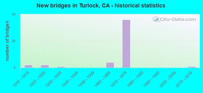
- New bridges - historical statistics
- 21910-1919
- 21920-1929
- 11930-1939
- 41960-1969
- 361970-1979
- 12010-2019


- Bridge Condition - Deck
- 64.3%Good
- 3.6%Satisfactory
- 17.9%Fair
- 14.3%Poor

- Bridge Condition - Superstructure
- 71.4%Good
- 10.7%Satisfactory
- 7.1%Fair
- 10.7%Poor

- Bridge Condition - Substructure
- 89.3%Good
- 3.6%Satisfactory
- 7.1%Fair
Find on map >> Show street view
Structure Number: 38 0053L, Location: 10-STA-099-R1.63-TUR (Lat: 37.473719, Lng: -120.848797), Route carried "on" structure: State highway 99, Year Built: 1973, Status: Open, Structure Length: 4.60m (15.09ft), Average Daily Traffic: 39,500 (year 2009), Truck Traffic: 17%, Average Future Daily Traffic: 34,905 (year 2038), Design Load: HS 20, Features Intersected: ST RTE 165 (LANDER AVE)
Minimum Vertical Clearance: 30+ m (98+ ft), Kilometerpoint: 1.630, Lanes on structure: 3, Lanes under structure: 5, Base Highway Network: Yes (, Subroute: 1), Owner: State Highway Agency, Approaching Roadway Width: 15.5m (50.9ft), Skew: 2 degrees, Material/Design: Prestressed concrete, Design/Construction: Box Beam or Girders - Multiple, Number Of Spans In Main Unit: 1, Length of Maximum Span: 45.9m (150.6ft), Curb-To-Curb Width: 15.5m (50.9ft), Out-to-Out Width: 16.2m (53.1ft)
Condition: Deck: Good, Superstructure: Good, Substructure: Good, Operating Rating: 51.5 metric tons, Method Used To Determine Operating Rating: Load and Resistance Factor Rating (LRFR) rating reported by rating factor(RF) method using HL-93 loadings, Inventory Rating: 28.5 metric tons, Method Used To Determine Inventory Rating: Load and Resistance Factor Rating (LRFR) rating reported by rating factor(RF) method using HL-93 loadings, Structural Evaluation: Better than present minimum criteria, Deck Geometry: Somewhat better than minimum adequacy, Underclear: Meets minimum limits, Approach Roadway Alignment: Equal to present desirable criteria, Designated Inspection Frequency: Every 24 months, Inspection Date: March 2021, Deck Structure Type: Concrete Cast-file-Place, Wearing Surface/Protective System: Wearing Surface: Bituminous
Find on map >> Show street view
Structure Number: 38 0053R, Location: 10-STA-099-R1.63-TUR (Lat: 37.473989, Lng: -120.848800), Route carried "on" structure: State highway 99, Year Built: 1973, Status: Open, Structure Length: 4.60m (15.09ft), Average Daily Traffic: 39,500 (year 2009), Truck Traffic: 17%, Average Future Daily Traffic: 34,905 (year 2038), Design Load: HS 20, Features Intersected: ST RTE 165 (LANDER AVE)
Minimum Vertical Clearance: 30+ m (98+ ft), Kilometerpoint: 1.630, Lanes on structure: 3, Lanes under structure: 5, Base Highway Network: Yes (, Subroute: 1), Owner: State Highway Agency, Approaching Roadway Width: 15.5m (50.9ft), Skew: 2 degrees, Material/Design: Prestressed concrete, Design/Construction: Box Beam or Girders - Multiple, Number Of Spans In Main Unit: 1, Length of Maximum Span: 45.9m (150.6ft), Curb-To-Curb Width: 15.5m (50.9ft), Out-to-Out Width: 16.2m (53.1ft)
Condition: Deck: Good, Superstructure: Good, Substructure: Good, Operating Rating: 51.5 metric tons, Method Used To Determine Operating Rating: Load and Resistance Factor Rating (LRFR) rating reported by rating factor(RF) method using HL-93 loadings, Inventory Rating: 28.5 metric tons, Method Used To Determine Inventory Rating: Load and Resistance Factor Rating (LRFR) rating reported by rating factor(RF) method using HL-93 loadings, Structural Evaluation: Better than present minimum criteria, Deck Geometry: Somewhat better than minimum adequacy, Underclear: High priority of corrective action, Approach Roadway Alignment: Equal to present desirable criteria, Designated Inspection Frequency: Every 24 months, Inspection Date: March 2021, Deck Structure Type: Concrete Cast-file-Place, Wearing Surface/Protective System: Wearing Surface: Bituminous
Find on map >> Show street view
Structure Number: 38 0072, Location: 10-STA-099-R11.55-CER (Lat: 37.590894, Lng: -120.955678), Route carried "on" structure: State highway 99, Year Built: 1965, Status: Open, Structure Length: 4.18m (13.71ft), Average Daily Traffic: 101,000 (year 2009), Truck Traffic: 13%, Average Future Daily Traffic: 158,705 (year 2038), Design Load: HS 20, Features Intersected: SECOND ST-SB 99 ON RAMP
Minimum Vertical Clearance: 30+ m (98+ ft), Kilometerpoint: 11.550, Lanes on structure: 6, Lanes under structure: 2, Base Highway Network: Yes (, Subroute: 1), Owner: State Highway Agency, Approaching Roadway Width: 35.1m (115.2ft), Skew: 32 degrees, Material/Design: Concrete continuous, Design/Construction: Tee Beam, Number Of Spans In Main Unit: 3, Length of Maximum Span: 19.5m (64.0ft), Curb or Sidewalk Widths: Left: 0.0m, Right: 0.6m (2.0ft), Curb-To-Curb Width: 34.7m (113.8ft), Out-to-Out Width: 36.1m (118.4ft)
Condition: Deck: Poor, Superstructure: Good, Substructure: Good, Operating Rating: 39.5 metric tons, Method Used To Determine Operating Rating: Load and Resistance Factor Rating (LRFR) rating reported by rating factor(RF) method using HL-93 loadings, Inventory Rating: 30.5 metric tons, Method Used To Determine Inventory Rating: Load and Resistance Factor Rating (LRFR) rating reported by rating factor(RF) method using HL-93 loadings, Structural Evaluation: Better than present minimum criteria, Deck Geometry: Superior to present desirable criteria, Underclear: Meets minimum limits, Approach Roadway Alignment: Equal to present desirable criteria, Designated Inspection Frequency: Every 24 months, Inspection Date: March 2021, Deck Structure Type: Concrete Cast-file-Place
Find on map >> Show street view
Structure Number: 38 0077, Location: 10-STA-099-R14.47-TUR (Lat: 37.618347, Lng: -120.993486), Route carried "on" structure: County highway , Year Built: 1963, Status: Open, Structure Length: 9.08m (29.79ft), Average Daily Traffic: 25,600 (year 2011), Truck Traffic: 3%, Average Future Daily Traffic: 49,215 (year 2041), Design Load: HS 20, Features Intersected: STATE ROUTE 99 & RAMP, Facility Carried by Structure: CROWS LANDING ROAD
Minimum Vertical Clearance: 30+ m (98+ ft), Kilometerpoint: 0.000, Lanes on structure: 2, Lanes under structure: 7, Owner: State Highway Agency, Approaching Roadway Width: 21.0m (68.9ft), Skew: 4 degrees, Material/Design: Concrete continuous, Design/Construction: Box Beam or Girders - Multiple, Number Of Spans In Main Unit: 3, Length of Maximum Span: 38.1m (125.0ft), Curb or Sidewalk Widths: Left: 1.6m (5.2ft), Right: 1.6m (5.2ft), Curb-To-Curb Width: 15.8m (51.8ft), Out-to-Out Width: 20.2m (66.3ft)
Condition: Deck: Good, Superstructure: Good, Substructure: Good, Operating Rating: 46.7 metric tons, Method Used To Determine Operating Rating: Load and Resistance Factor Rating (LRFR) rating reported by rating factor(RF) method using HL-93 loadings, Inventory Rating: 34.0 metric tons, Method Used To Determine Inventory Rating: Load and Resistance Factor Rating (LRFR) rating reported by rating factor(RF) method using HL-93 loadings, Structural Evaluation: Better than present minimum criteria, Deck Geometry: Superior to present desirable criteria, Underclear: High priority of corrective action, Approach Roadway Alignment: Equal to present desirable criteria, Designated Inspection Frequency: Every 24 months, Inspection Date: March 2021, Deck Structure Type: Concrete Cast-file-Place
Find on map >> Show street view
Structure Number: 38 0079, Location: 10-STA-099-R2.29-TUR (Lat: 37.478119, Lng: -120.859914), Route carried "on" structure: City street , Year Built: 1973, Status: Open, Structure Length: 10.18m (33.40ft), Average Daily Traffic: 2,500 (year 2006), Truck Traffic: 2%, Average Future Daily Traffic: 3,902 (year 2038), Design Load: HS 20, Features Intersected: STATE ROUTE 99, Facility Carried by Structure: LINWOOD AVE
Minimum Vertical Clearance: 30+ m (98+ ft), Kilometerpoint: 0.000, Lanes on structure: 2, Lanes under structure: 6, Owner: State Highway Agency, Approaching Roadway Width: 15.2m (49.9ft), Skew: 5 degrees, Material/Design: Prestressed concrete continuous, Design/Construction: Box Beam or Girders - Multiple, Number Of Spans In Main Unit: 2, Length of Maximum Span: 52.0m (170.6ft), Curb or Sidewalk Widths: Left: 1.5m (4.9ft), Right: 1.5m (4.9ft), Curb-To-Curb Width: 12.2m (40.0ft), Out-to-Out Width: 15.8m (51.8ft)
Condition: Deck: Fair, Superstructure: Good, Substructure: Good, Operating Rating: 91.0 metric tons, Method Used To Determine Operating Rating: Load Factor (LF), Inventory Rating: 32.4 metric tons, Method Used To Determine Inventory Rating: Load Factor (LF), Structural Evaluation: Better than present minimum criteria, Deck Geometry: Equal to present minimum criteria, Underclear: Somewhat better than minimum adequacy, Approach Roadway Alignment: Equal to present desirable criteria, Designated Inspection Frequency: Every 24 months, Inspection Date: March 2021, Deck Structure Type: Concrete Cast-file-Place
Find on map >> Show street view
Structure Number: 38 0120L, Location: 10-STA-005-17.25 (Lat: 37.479258, Lng: -121.196189), Route carried "on" structure: Interstate 5, Year Built: 1967, Status: Open, Structure Length: 2.62m (8.60ft), Average Daily Traffic: 20,500 (year 2009), Truck Traffic: 25%, Average Future Daily Traffic: 26,837 (year 2040), Design Load: HS 20, Features Intersected: HANSON ROAD (PRIVATE)
Minimum Vertical Clearance: 30+ m (98+ ft), Kilometerpoint: 17.250, Lanes on structure: 2, Base Highway Network: Yes (, Subroute: 1), Owner: State Highway Agency, Approaching Roadway Width: 11.0m (36.1ft), Skew: 2 degrees, Material/Design: Concrete continuous, Design/Construction: Slab, Number Of Spans In Main Unit: 3, Length of Maximum Span: 10.4m (34.1ft), Curb-To-Curb Width: 12.1m (39.7ft), Out-to-Out Width: 12.9m (42.3ft)
Condition: Deck: Fair, Superstructure: Fair, Substructure: Good, Operating Rating: 70.0 metric tons, Method Used To Determine Operating Rating: Load Factor (LF), Inventory Rating: 42.1 metric tons, Method Used To Determine Inventory Rating: Load Factor (LF), Structural Evaluation: Somewhat better than minimum adequacy, Deck Geometry: Equal to present minimum criteria, Approach Roadway Alignment: Equal to present desirable criteria, Designated Inspection Frequency: Every 24 months, Inspection Date: Febuary 2022, Deck Structure Type: Concrete Cast-file-Place
Find on map >> Show street view
Structure Number: 38 0124L, Location: 10-STA-099-R3.08-TUR (Lat: 37.487542, Lng: -120.867339), Route carried "on" structure: State highway 99, Year Built: 1973, Status: Open, Structure Length: 3.20m (10.50ft), Average Daily Traffic: 39,500 (year 2009), Truck Traffic: 17%, Average Future Daily Traffic: 34,905 (year 2038), Design Load: HS 20, Features Intersected: WALNUT AVE
Minimum Vertical Clearance: 30+ m (98+ ft), Kilometerpoint: 3.080, Lanes on structure: 3, Lanes under structure: 2, Base Highway Network: Yes (, Subroute: 1), Owner: State Highway Agency, Approaching Roadway Width: 15.5m (50.9ft), Material/Design: Prestressed concrete, Design/Construction: Box Beam or Girders - Multiple, Number Of Spans In Main Unit: 1, Length of Maximum Span: 32.0m (105.0ft), Curb-To-Curb Width: 15.5m (50.9ft), Out-to-Out Width: 16.2m (53.1ft)
Condition: Deck: Good, Superstructure: Good, Substructure: Good, Operating Rating: 41.8 metric tons, Method Used To Determine Operating Rating: Load and Resistance Factor Rating (LRFR) rating reported by rating factor(RF) method using HL-93 loadings, Inventory Rating: 28.5 metric tons, Method Used To Determine Inventory Rating: Load and Resistance Factor Rating (LRFR) rating reported by rating factor(RF) method using HL-93 loadings, Structural Evaluation: Better than present minimum criteria, Deck Geometry: Somewhat better than minimum adequacy, Underclear: Somewhat better than minimum adequacy, Approach Roadway Alignment: Equal to present desirable criteria, Designated Inspection Frequency: Every 24 months, Inspection Date: March 2021, Deck Structure Type: Concrete Cast-file-Place, Wearing Surface/Protective System: Wearing Surface: Bituminous
Find on map >> Show street view
Structure Number: 38 0124R, Location: 10-STA-099-R3.08-TUR (Lat: 37.487631, Lng: -120.867067), Route carried "on" structure: State highway 99, Year Built: 1973, Status: Open, Structure Length: 3.20m (10.50ft), Average Daily Traffic: 39,500 (year 2009), Truck Traffic: 17%, Average Future Daily Traffic: 34,905 (year 2038), Design Load: HS 20, Features Intersected: WALNUT AVE
Minimum Vertical Clearance: 30+ m (98+ ft), Kilometerpoint: 3.080, Lanes on structure: 3, Lanes under structure: 2, Base Highway Network: Yes (, Subroute: 1), Owner: State Highway Agency, Approaching Roadway Width: 15.5m (50.9ft), Material/Design: Prestressed concrete, Design/Construction: Box Beam or Girders - Multiple, Number Of Spans In Main Unit: 1, Length of Maximum Span: 32.0m (105.0ft), Curb-To-Curb Width: 15.5m (50.9ft), Out-to-Out Width: 16.2m (53.1ft)
Condition: Deck: Good, Superstructure: Good, Substructure: Good, Operating Rating: 41.8 metric tons, Method Used To Determine Operating Rating: Load and Resistance Factor Rating (LRFR) rating reported by rating factor(RF) method using HL-93 loadings, Inventory Rating: 28.5 metric tons, Method Used To Determine Inventory Rating: Load and Resistance Factor Rating (LRFR) rating reported by rating factor(RF) method using HL-93 loadings, Structural Evaluation: Better than present minimum criteria, Deck Geometry: Somewhat better than minimum adequacy, Underclear: Meets minimum limits, Approach Roadway Alignment: Equal to present desirable criteria, Designated Inspection Frequency: Every 24 months, Inspection Date: March 2021, Deck Structure Type: Concrete Cast-file-Place, Wearing Surface/Protective System: Wearing Surface: Bituminous
Find on map >> Show street view
Structure Number: 38 0128L, Location: 10-STA-099-R3.18-TUR (Lat: 37.488931, Lng: -120.868075), Route carried "on" structure: State highway 99, Year Built: 1973, Status: Open, Structure Length: 4.08m (13.39ft), Average Daily Traffic: 39,500 (year 2009), Truck Traffic: 17%, Average Future Daily Traffic: 34,905 (year 2038), Design Load: HS 20+Mod, Features Intersected: UP RR
Minimum Vertical Clearance: 30+ m (98+ ft), Kilometerpoint: 3.180, Lanes on structure: 3, Base Highway Network: Yes (, Subroute: 1), Owner: State Highway Agency, Approaching Roadway Width: 16.8m (55.1ft), Skew: 2 degrees, Material/Design: Concrete continuous, Design/Construction: Tee Beam, Number Of Spans In Main Unit: 3, Length of Maximum Span: 16.6m (54.5ft), Curb-To-Curb Width: 16.7m (54.8ft), Out-to-Out Width: 17.3m (56.8ft)
Condition: Deck: Fair, Superstructure: Good, Substructure: Good, Operating Rating: 50.9 metric tons, Method Used To Determine Operating Rating: Load and Resistance Factor Rating (LRFR) rating reported by rating factor(RF) method using HL-93 loadings, Inventory Rating: 37.3 metric tons, Method Used To Determine Inventory Rating: Load and Resistance Factor Rating (LRFR) rating reported by rating factor(RF) method using HL-93 loadings, Structural Evaluation: Better than present minimum criteria, Deck Geometry: Equal to present minimum criteria, Underclear: Equal to present minimum criteria, Approach Roadway Alignment: Equal to present desirable criteria, Designated Inspection Frequency: Every 24 months, Inspection Date: March 2021, Deck Structure Type: Concrete Cast-file-Place
Find on map >> Show street view
Structure Number: 38 0128R, Location: 10-STA-099-R3.18-TUR (Lat: 37.488931, Lng: -120.867750), Route carried "on" structure: State highway 99, Year Built: 1973, Status: Open, Structure Length: 4.08m (13.39ft), Average Daily Traffic: 39,500 (year 2009), Truck Traffic: 17%, Average Future Daily Traffic: 34,905 (year 2038), Design Load: HS 20+Mod, Features Intersected: UP RR
Minimum Vertical Clearance: 30+ m (98+ ft), Kilometerpoint: 3.180, Lanes on structure: 3, Base Highway Network: Yes (, Subroute: 1), Owner: State Highway Agency, Approaching Roadway Width: 15.5m (50.9ft), Skew: 2 degrees, Material/Design: Concrete continuous, Design/Construction: Tee Beam, Number Of Spans In Main Unit: 3, Length of Maximum Span: 16.6m (54.5ft), Curb-To-Curb Width: 15.5m (50.9ft), Out-to-Out Width: 16.2m (53.1ft)
Condition: Deck: Fair, Superstructure: Good, Substructure: Good, Operating Rating: 51.5 metric tons, Method Used To Determine Operating Rating: Load and Resistance Factor Rating (LRFR) rating reported by rating factor(RF) method using HL-93 loadings, Inventory Rating: 39.9 metric tons, Method Used To Determine Inventory Rating: Load and Resistance Factor Rating (LRFR) rating reported by rating factor(RF) method using HL-93 loadings, Structural Evaluation: Better than present minimum criteria, Deck Geometry: Somewhat better than minimum adequacy, Underclear: Equal to present minimum criteria, Approach Roadway Alignment: Equal to present desirable criteria, Designated Inspection Frequency: Every 24 months, Inspection Date: March 2021, Deck Structure Type: Concrete Cast-file-Place
Find on map >> Show street view
Structure Number: 38 0138, Location: 10-STA-099-R0.52-TUR (Lat: 37.466322, Lng: -120.830739), Route carried "on" structure: County highway , Year Built: 1973, Status: Open, Structure Length: 7.53m (24.70ft), Average Daily Traffic: 500 (year 2006), Truck Traffic: 1%, Average Future Daily Traffic: 780 (year 2038), Design Load: HS 20, Features Intersected: STATE ROUTE 99, Facility Carried by Structure: GOLF RD
Minimum Vertical Clearance: 30+ m (98+ ft), Kilometerpoint: 0.000, Lanes on structure: 2, Lanes under structure: 6, Owner: State Highway Agency, Approaching Roadway Width: 10.4m (34.1ft), Skew: 2 degrees, Material/Design: Prestressed concrete continuous, Design/Construction: Box Beam or Girders - Multiple, Number Of Spans In Main Unit: 2, Length of Maximum Span: 39.9m (130.9ft), Curb-To-Curb Width: 10.4m (34.1ft), Out-to-Out Width: 11.0m (36.1ft)
Condition: Deck: Satisfactory, Superstructure: Good, Substructure: Good, Operating Rating: 58.0 metric tons, Method Used To Determine Operating Rating: Load and Resistance Factor Rating (LRFR) rating reported by rating factor(RF) method using HL-93 loadings, Inventory Rating: 42.4 metric tons, Method Used To Determine Inventory Rating: Load and Resistance Factor Rating (LRFR) rating reported by rating factor(RF) method using HL-93 loadings, Structural Evaluation: Better than present minimum criteria, Deck Geometry: Equal to present minimum criteria, Underclear: Better than present minimum criteria, Approach Roadway Alignment: Equal to present desirable criteria, Designated Inspection Frequency: Every 24 months, Inspection Date: March 2021, Deck Structure Type: Concrete Cast-file-Place
Find on map >> Show street view
Structure Number: 38 0141L, Location: 10-STA-099-R3.45-TUR (Lat: 37.492547, Lng: -120.870006), Route carried "on" structure: State highway 99, Year Built: 1973, Status: Open, Structure Length: 4.33m (14.21ft), Average Daily Traffic: 39,500 (year 2011), Truck Traffic: 17%, Average Future Daily Traffic: 34,905 (year 2038), Design Load: HS 20, Features Intersected: WEST MAIN STREET
Minimum Vertical Clearance: 30+ m (98+ ft), Kilometerpoint: 3.450, Lanes on structure: 3, Lanes under structure: 6, Base Highway Network: Yes (, Subroute: 1), Owner: State Highway Agency, Approaching Roadway Width: 15.5m (50.9ft), Skew: 2 degrees, Material/Design: Prestressed concrete, Design/Construction: Box Beam or Girders - Multiple, Number Of Spans In Main Unit: 1, Length of Maximum Span: 43.3m (142.1ft), Curb-To-Curb Width: 15.5m (50.9ft), Out-to-Out Width: 16.2m (53.1ft)
Condition: Deck: Good, Superstructure: Good, Substructure: Good, Operating Rating: 55.1 metric tons, Method Used To Determine Operating Rating: Load and Resistance Factor Rating (LRFR) rating reported by rating factor(RF) method using HL-93 loadings, Inventory Rating: 32.4 metric tons, Method Used To Determine Inventory Rating: Load and Resistance Factor Rating (LRFR) rating reported by rating factor(RF) method using HL-93 loadings, Structural Evaluation: Better than present minimum criteria, Deck Geometry: Somewhat better than minimum adequacy, Underclear: High priority of corrective action, Approach Roadway Alignment: Equal to present desirable criteria, Designated Inspection Frequency: Every 24 months, Inspection Date: March 2021, Deck Structure Type: Concrete Cast-file-Place, Wearing Surface/Protective System: Wearing Surface: Bituminous
Find on map >> Show street view
Structure Number: 38 0141R, Location: 10-STA-099-R3.45-TUR (Lat: 37.492550, Lng: -120.869683), Route carried "on" structure: State highway 99, Year Built: 1973, Status: Open, Structure Length: 4.33m (14.21ft), Average Daily Traffic: 39,500 (year 2009), Truck Traffic: 17%, Average Future Daily Traffic: 34,905 (year 2038), Design Load: HS 20, Features Intersected: WEST MAIN STREET
Minimum Vertical Clearance: 30+ m (98+ ft), Kilometerpoint: 3.450, Lanes on structure: 3, Lanes under structure: 6, Base Highway Network: Yes (, Subroute: 1), Owner: State Highway Agency, Approaching Roadway Width: 15.5m (50.9ft), Skew: 2 degrees, Material/Design: Prestressed concrete, Design/Construction: Box Beam or Girders - Multiple, Number Of Spans In Main Unit: 1, Length of Maximum Span: 43.3m (142.1ft), Curb-To-Curb Width: 15.5m (50.9ft), Out-to-Out Width: 16.2m (53.1ft)
Condition: Deck: Good, Superstructure: Good, Substructure: Good, Operating Rating: 55.1 metric tons, Method Used To Determine Operating Rating: Load and Resistance Factor Rating (LRFR) rating reported by rating factor(RF) method using HL-93 loadings, Inventory Rating: 32.4 metric tons, Method Used To Determine Inventory Rating: Load and Resistance Factor Rating (LRFR) rating reported by rating factor(RF) method using HL-93 loadings, Structural Evaluation: Better than present minimum criteria, Deck Geometry: Somewhat better than minimum adequacy, Underclear: High priority of corrective action, Approach Roadway Alignment: Equal to present desirable criteria, Designated Inspection Frequency: Every 24 months, Inspection Date: March 2021, Deck Structure Type: Concrete Cast-file-Place, Wearing Surface/Protective System: Wearing Surface: Bituminous
Find on map >> Show street view
Structure Number: 38 0142L, Location: 10-STA-099-R4.54-TUR (Lat: 37.507086, Lng: -120.877769), Route carried "on" structure: State highway 99, Year Built: 1973, Status: Open, Structure Length: 3.90m (12.80ft), Average Daily Traffic: 36,500 (year 2011), Truck Traffic: 17%, Average Future Daily Traffic: 46,054 (year 2038), Design Load: HS 20, Features Intersected: FULKERTH ROAD
Minimum Vertical Clearance: 30+ m (98+ ft), Kilometerpoint: 4.540, Lanes on structure: 3, Lanes under structure: 5, Base Highway Network: Yes (, Subroute: 1), Owner: State Highway Agency, Approaching Roadway Width: 15.5m (50.9ft), Skew: 2 degrees, Material/Design: Prestressed concrete, Design/Construction: Box Beam or Girders - Multiple, Number Of Spans In Main Unit: 1, Length of Maximum Span: 39.0m (128.0ft), Curb-To-Curb Width: 15.5m (50.9ft), Out-to-Out Width: 16.2m (53.1ft)
Condition: Deck: Good, Superstructure: Good, Substructure: Good, Operating Rating: 61.9 metric tons, Method Used To Determine Operating Rating: Load and Resistance Factor Rating (LRFR) rating reported by rating factor(RF) method using HL-93 loadings, Inventory Rating: 40.5 metric tons, Method Used To Determine Inventory Rating: Load and Resistance Factor Rating (LRFR) rating reported by rating factor(RF) method using HL-93 loadings, Structural Evaluation: Better than present minimum criteria, Deck Geometry: Somewhat better than minimum adequacy, Underclear: High priority of corrective action, Approach Roadway Alignment: Equal to present desirable criteria, Designated Inspection Frequency: Every 24 months, Inspection Date: March 2021, Deck Structure Type: Concrete Cast-file-Place, Wearing Surface/Protective System: Wearing Surface: Bituminous
Find on map >> Show street view
Structure Number: 38 0142R, Location: 10-STA-099-R4.54-TUR (Lat: 37.507089, Lng: -120.877436), Route carried "on" structure: State highway 99, Year Built: 1973, Status: Open, Structure Length: 3.90m (12.80ft), Average Daily Traffic: 36,500 (year 2009), Truck Traffic: 17%, Average Future Daily Traffic: 46,054 (year 2038), Design Load: HS 20, Features Intersected: FULKERTH ROAD
Minimum Vertical Clearance: 30+ m (98+ ft), Kilometerpoint: 4.540, Lanes on structure: 3, Lanes under structure: 4, Base Highway Network: Yes (, Subroute: 1), Owner: State Highway Agency, Approaching Roadway Width: 15.5m (50.9ft), Skew: 2 degrees, Material/Design: Prestressed concrete, Design/Construction: Box Beam or Girders - Multiple, Number Of Spans In Main Unit: 1, Length of Maximum Span: 39.0m (128.0ft), Curb-To-Curb Width: 15.5m (50.9ft), Out-to-Out Width: 16.2m (53.1ft)
Condition: Deck: Good, Superstructure: Good, Substructure: Good, Operating Rating: 61.9 metric tons, Method Used To Determine Operating Rating: Load and Resistance Factor Rating (LRFR) rating reported by rating factor(RF) method using HL-93 loadings, Inventory Rating: 40.5 metric tons, Method Used To Determine Inventory Rating: Load and Resistance Factor Rating (LRFR) rating reported by rating factor(RF) method using HL-93 loadings, Structural Evaluation: Better than present minimum criteria, Deck Geometry: Somewhat better than minimum adequacy, Underclear: High priority of corrective action, Approach Roadway Alignment: Equal to present desirable criteria, Designated Inspection Frequency: Every 24 months, Inspection Date: March 2021, Deck Structure Type: Concrete Cast-file-Place, Wearing Surface/Protective System: Wearing Surface: Bituminous
Find on map >> Show street view
Structure Number: 38 0143L, Location: 10-STA-099-R5.64-TUR (Lat: 37.521739, Lng: -120.885583), Route carried "on" structure: State highway 99, Year Built: 1973, Status: Open, Structure Length: 4.45m (14.60ft), Average Daily Traffic: 36,500 (year 2011), Truck Traffic: 17%, Average Future Daily Traffic: 46,363 (year 2041), Design Load: HS 20, Features Intersected: MONTE VISTA AVE
Minimum Vertical Clearance: 30+ m (98+ ft), Kilometerpoint: 5.640, Lanes on structure: 3, Lanes under structure: 6, Base Highway Network: Yes (, Subroute: 1), Owner: State Highway Agency, Approaching Roadway Width: 15.5m (50.9ft), Skew: 2 degrees, Material/Design: Prestressed concrete, Design/Construction: Box Beam or Girders - Multiple, Number Of Spans In Main Unit: 1, Length of Maximum Span: 44.4m (145.7ft), Curb-To-Curb Width: 15.5m (50.9ft), Out-to-Out Width: 16.2m (53.1ft)
Condition: Deck: Good, Superstructure: Good, Substructure: Good, Operating Rating: 50.9 metric tons, Method Used To Determine Operating Rating: Load and Resistance Factor Rating (LRFR) rating reported by rating factor(RF) method using HL-93 loadings, Inventory Rating: 28.8 metric tons, Method Used To Determine Inventory Rating: Load and Resistance Factor Rating (LRFR) rating reported by rating factor(RF) method using HL-93 loadings, Structural Evaluation: Better than present minimum criteria, Deck Geometry: Somewhat better than minimum adequacy, Underclear: Meets minimum limits, Approach Roadway Alignment: Equal to present desirable criteria, Designated Inspection Frequency: Every 24 months, Inspection Date: March 2021, Deck Structure Type: Concrete Cast-file-Place, Wearing Surface/Protective System: Wearing Surface: Bituminous
Find on map >> Show street view
Structure Number: 38 0143R, Location: 10-STA-099-R5.64-TUR (Lat: 37.521739, Lng: -120.885256), Route carried "on" structure: State highway 99, Year Built: 1973, Status: Open, Structure Length: 4.45m (14.60ft), Average Daily Traffic: 36,500 (year 2009), Truck Traffic: 17%, Average Future Daily Traffic: 46,363 (year 2041), Design Load: HS 20, Features Intersected: MONTE VISTA AVE
Minimum Vertical Clearance: 30+ m (98+ ft), Kilometerpoint: 5.640, Lanes on structure: 3, Lanes under structure: 6, Base Highway Network: Yes (, Subroute: 1), Owner: State Highway Agency, Approaching Roadway Width: 15.5m (50.9ft), Skew: 2 degrees, Material/Design: Prestressed concrete, Design/Construction: Box Beam or Girders - Multiple, Number Of Spans In Main Unit: 1, Length of Maximum Span: 44.4m (145.7ft), Curb-To-Curb Width: 15.5m (50.9ft), Out-to-Out Width: 16.2m (53.1ft)
Condition: Deck: Good, Superstructure: Good, Substructure: Good, Operating Rating: 50.9 metric tons, Method Used To Determine Operating Rating: Load and Resistance Factor Rating (LRFR) rating reported by rating factor(RF) method using HL-93 loadings, Inventory Rating: 28.8 metric tons, Method Used To Determine Inventory Rating: Load and Resistance Factor Rating (LRFR) rating reported by rating factor(RF) method using HL-93 loadings, Structural Evaluation: Better than present minimum criteria, Deck Geometry: Somewhat better than minimum adequacy, Underclear: Meets minimum limits, Approach Roadway Alignment: Equal to present desirable criteria, Designated Inspection Frequency: Every 24 months, Inspection Date: March 2021, Deck Structure Type: Concrete Cast-file-Place, Wearing Surface/Protective System: Wearing Surface: Bituminous
Find on map >> Show street view
Structure Number: 38 0144L, Location: 10-STA-099-R6.41-TUR (Lat: 37.532383, Lng: -120.890406), Route carried "on" structure: State highway 99, Year Built: 1973, Status: Open, Structure Length: 7.19m (23.59ft), Average Daily Traffic: 36,500 (year 2011), Truck Traffic: 17%, Average Future Daily Traffic: 46,054 (year 2038), Design Load: HS 20+Mod, Features Intersected: UP RR
Minimum Vertical Clearance: 30+ m (98+ ft), Kilometerpoint: 6.410, Lanes on structure: 3, Base Highway Network: Yes (, Subroute: 1), Owner: State Highway Agency, Approaching Roadway Width: 15.5m (50.9ft), Skew: 5 degrees, Material/Design: Concrete continuous, Design/Construction: Box Beam or Girders - Multiple, Number Of Spans In Main Unit: 3, Length of Maximum Span: 29.0m (95.1ft), Curb-To-Curb Width: 15.5m (50.9ft), Out-to-Out Width: 17.3m (56.8ft)
Condition: Deck: Good, Superstructure: Satisfactory, Substructure: Good, Operating Rating: 96.2 metric tons, Method Used To Determine Operating Rating: Load Factor (LF), Inventory Rating: 57.7 metric tons, Method Used To Determine Inventory Rating: Load Factor (LF), Structural Evaluation: Equal to present minimum criteria, Deck Geometry: Somewhat better than minimum adequacy, Underclear: Better than present minimum criteria, Approach Roadway Alignment: Equal to present desirable criteria, Designated Inspection Frequency: Every 24 months, Inspection Date: March 2021, Deck Structure Type: Concrete Cast-file-Place
Find on map >> Show street view
Structure Number: 38 0144R, Location: 10-STA-099-R6.41-TUR (Lat: 37.531978, Lng: -120.889936), Route carried "on" structure: State highway 99, Year Built: 1973, Status: Open, Structure Length: 7.19m (23.59ft), Average Daily Traffic: 36,500 (year 2009), Truck Traffic: 17%, Average Future Daily Traffic: 46,054 (year 2038), Design Load: HS 20+Mod, Features Intersected: UP RR
Minimum Vertical Clearance: 30+ m (98+ ft), Kilometerpoint: 6.410, Lanes on structure: 3, Base Highway Network: Yes (, Subroute: 1), Owner: State Highway Agency, Approaching Roadway Width: 15.5m (50.9ft), Skew: 5 degrees, Material/Design: Concrete continuous, Design/Construction: Box Beam or Girders - Multiple, Number Of Spans In Main Unit: 3, Length of Maximum Span: 29.0m (95.1ft), Curb-To-Curb Width: 15.5m (50.9ft), Out-to-Out Width: 16.2m (53.1ft)
Condition: Deck: Good, Superstructure: Satisfactory, Substructure: Good, Operating Rating: 93.6 metric tons, Method Used To Determine Operating Rating: Load and Resistance Factor Rating (LRFR) rating reported by rating factor(RF) method using HL-93 loadings, Inventory Rating: 68.4 metric tons, Method Used To Determine Inventory Rating: Load and Resistance Factor Rating (LRFR) rating reported by rating factor(RF) method using HL-93 loadings, Structural Evaluation: Equal to present minimum criteria, Deck Geometry: Somewhat better than minimum adequacy, Underclear: Better than present minimum criteria, Approach Roadway Alignment: Equal to present desirable criteria, Designated Inspection Frequency: Every 24 months, Inspection Date: March 2021, Deck Structure Type: Concrete Cast-file-Place
Find on map >> Show street view
Structure Number: 38 0145L, Location: 10-STA-099-R6.75-TUR (Lat: 37.536925, Lng: -120.892303), Route carried "on" structure: State highway 99, Year Built: 1973, Status: Open, Structure Length: 4.39m (14.40ft), Average Daily Traffic: 39,000 (year 2011), Truck Traffic: 16%, Average Future Daily Traffic: 51,949 (year 2041), Design Load: HS 20, Features Intersected: TAYLOR RD
Minimum Vertical Clearance: 30+ m (98+ ft), Kilometerpoint: 6.750, Lanes on structure: 3, Lanes under structure: 3, Base Highway Network: Yes (, Subroute: 1), Owner: State Highway Agency, Approaching Roadway Width: 15.5m (50.9ft), Skew: 3 degrees, Material/Design: Prestressed concrete, Design/Construction: Box Beam or Girders - Multiple, Number Of Spans In Main Unit: 1, Length of Maximum Span: 43.8m (143.7ft), Curb-To-Curb Width: 15.5m (50.9ft), Out-to-Out Width: 16.2m (53.1ft)
Condition: Deck: Good, Superstructure: Good, Substructure: Good, Operating Rating: 53.8 metric tons, Method Used To Determine Operating Rating: Load and Resistance Factor Rating (LRFR) rating reported by rating factor(RF) method using HL-93 loadings, Inventory Rating: 30.8 metric tons, Method Used To Determine Inventory Rating: Load and Resistance Factor Rating (LRFR) rating reported by rating factor(RF) method using HL-93 loadings, Structural Evaluation: Better than present minimum criteria, Deck Geometry: Equal to present minimum criteria, Underclear: Meets minimum limits, Approach Roadway Alignment: Equal to present desirable criteria, Designated Inspection Frequency: Every 24 months, Inspection Date: March 2021, Deck Structure Type: Concrete Cast-file-Place, Wearing Surface/Protective System: Wearing Surface: Bituminous
Find on map >> Show street view
Structure Number: 38 0145R, Location: 10-STA-099-R6.75-TUR (Lat: 37.536919, Lng: -120.891867), Route carried "on" structure: State highway 99, Year Built: 1973, Status: Open, Structure Length: 4.36m (14.30ft), Average Daily Traffic: 39,000 (year 2009), Truck Traffic: 16%, Average Future Daily Traffic: 51,949 (year 2041), Design Load: HS 20, Features Intersected: TAYLOR RD
Minimum Vertical Clearance: 30+ m (98+ ft), Kilometerpoint: 6.750, Lanes on structure: 3, Lanes under structure: 3, Base Highway Network: Yes (, Subroute: 1), Owner: State Highway Agency, Approaching Roadway Width: 15.5m (50.9ft), Skew: 3 degrees, Material/Design: Prestressed concrete, Design/Construction: Box Beam or Girders - Multiple, Number Of Spans In Main Unit: 1, Length of Maximum Span: 43.5m (142.7ft), Curb-To-Curb Width: 15.5m (50.9ft), Out-to-Out Width: 16.2m (53.1ft)
Condition: Deck: Good, Superstructure: Satisfactory, Substructure: Good, Operating Rating: 56.1 metric tons, Method Used To Determine Operating Rating: Load and Resistance Factor Rating (LRFR) rating reported by rating factor(RF) method using HL-93 loadings, Inventory Rating: 32.7 metric tons, Method Used To Determine Inventory Rating: Load and Resistance Factor Rating (LRFR) rating reported by rating factor(RF) method using HL-93 loadings, Structural Evaluation: Equal to present minimum criteria, Deck Geometry: Equal to present minimum criteria, Underclear: High priority of corrective action, Approach Roadway Alignment: Equal to present desirable criteria, Designated Inspection Frequency: Every 24 months, Inspection Date: March 2021, Deck Structure Type: Concrete Cast-file-Place, Wearing Surface/Protective System: Wearing Surface: Bituminous
Find on map >> Show street view
Structure Number: 38 0148, Location: 10-STA-099-R4.01-TUR (Lat: 37.500006, Lng: -120.874336), Route carried "on" structure: City street , Year Built: 1973, Status: Open, Structure Length: 6.80m (22.31ft), Average Daily Traffic: 4,200 (year 2011), Truck Traffic: 1%, Average Future Daily Traffic: 8,367 (year 2041), Design Load: HS 20, Features Intersected: STATE ROUTE 99, Facility Carried by Structure: CANAL DR
Minimum Vertical Clearance: 30+ m (98+ ft), Kilometerpoint: 0.000, Lanes on structure: 2, Lanes under structure: 6, Owner: State Highway Agency, Approaching Roadway Width: 12.2m (40.0ft), Skew: 2 degrees, Material/Design: Prestressed concrete continuous, Design/Construction: Box Beam or Girders - Multiple, Number Of Spans In Main Unit: 2, Length of Maximum Span: 35.1m (115.2ft), Curb-To-Curb Width: 12.2m (40.0ft), Out-to-Out Width: 12.8m (42.0ft)
Condition: Deck: Good, Superstructure: Good, Substructure: Satisfactory, Operating Rating: 54.4 metric tons, Method Used To Determine Operating Rating: Load and Resistance Factor Rating (LRFR) rating reported by rating factor(RF) method using HL-93 loadings, Inventory Rating: 39.2 metric tons, Method Used To Determine Inventory Rating: Load and Resistance Factor Rating (LRFR) rating reported by rating factor(RF) method using HL-93 loadings, Structural Evaluation: Equal to present minimum criteria, Deck Geometry: Equal to present minimum criteria, Underclear: Somewhat better than minimum adequacy, Approach Roadway Alignment: Equal to present desirable criteria, Designated Inspection Frequency: Every 24 months, Inspection Date: March 2021, Deck Structure Type: Concrete Cast-file-Place
Find on map >> Show street view
Structure Number: 38C019, Location: JCT AT HARDING AVE (Lat: 37.463581, Lng: -120.867178), Route carried "on" structure: County highway , Year Built: 1920, Status: Open, Structure Length: 0.73m (2.40ft), Average Daily Traffic: 1,738 (year 2014), Truck Traffic: 29%, Average Future Daily Traffic: 2,000 (year 2037), Design Load: H 10, Features Intersected: T.I.D. LATERAL #5, Facility Carried by Structure: WALNUT AVENUE
Minimum Vertical Clearance: 30+ m (98+ ft), Kilometerpoint: 0.000, Lanes on structure: 2, Owner: County Highway Agency, Approaching Roadway Width: 7.3m (24.0ft), Skew: 1 degrees, Material/Design: Concrete continuous, Design/Construction: Slab, Number Of Spans In Main Unit: 2, Length of Maximum Span: 3.4m (11.2ft), Curb or Sidewalk Widths: Left: 0.3m (1.0ft), Right: 0.0m, Curb-To-Curb Width: 8.2m (26.9ft), Out-to-Out Width: 9.0m (29.5ft)
Condition: Deck: Poor, Superstructure: Poor, Substructure: Fair, Channel: Excellent, Operating Rating: 53.5 metric tons, Method Used To Determine Operating Rating: Load Factor (LF), Inventory Rating: 32.1 metric tons, Method Used To Determine Inventory Rating: Load Factor (LF), Structural Evaluation: Meets minimum limits, Deck Geometry: Meets minimum limits, Waterway Adequacy: Superior to present desirable criteria, Approach Roadway Alignment: Equal to present desirable criteria, Length Of Structure Improvement: 0.73m (2.40ft), Designated Inspection Frequency: Every 24 months, Inspection Date: October 2020, Bridge Improvement Cost: $65,000, Roadway Improvement Cost: $13,000, Total Project Cost: $109,000 ( Estimate for 2021), Deck Structure Type: Concrete Cast-file-Place, Wearing Surface/Protective System: Wearing Surface: Bituminous
Find on map >> Show street view
Structure Number: 38C0191, Location: 0.5 MI N/O W. MAIN ST (Lat: 37.499861, Lng: -120.921439), Route carried "on" structure: County highway , Year Built: 1919, Status: Open, Structure Length: 0.70m (2.30ft), Average Daily Traffic: 1,461 (year 2015), Truck Traffic: 16%, Average Future Daily Traffic: 4,080 (year 2038), Design Load: H 10, Features Intersected: T.I.D. UPPER LATERAL #4, Facility Carried by Structure: FAITH HOME ROAD
Minimum Vertical Clearance: 30+ m (98+ ft), Kilometerpoint: 0.000, Lanes on structure: 2, Owner: County Highway Agency, Approaching Roadway Width: 6.4m (21.0ft), Material/Design: Concrete continuous, Design/Construction: Slab, Number Of Spans In Main Unit: 2, Length of Maximum Span: 3.4m (11.2ft), Curb-To-Curb Width: 7.6m (24.9ft), Out-to-Out Width: 7.8m (25.6ft)
Condition: Deck: Poor, Superstructure: Poor, Substructure: Fair, Channel: Excellent, Operating Rating: 47.3 metric tons, Method Used To Determine Operating Rating: Load Factor (LF), Inventory Rating: 28.2 metric tons, Method Used To Determine Inventory Rating: Load Factor (LF), Structural Evaluation: Meets minimum limits, Deck Geometry: Meets minimum limits, Waterway Adequacy: Superior to present desirable criteria, Approach Roadway Alignment: Equal to present desirable criteria, Length Of Structure Improvement: 0.70m (2.30ft), Designated Inspection Frequency: Every 24 months, Inspection Date: October 2020, Bridge Improvement Cost: $115,000, Deck Structure Type: Concrete Cast-file-Place, Wearing Surface/Protective System: Wearing Surface: Bituminous
Find on map >> Show street view
Structure Number: 38C0192, Location: 0.2 MI W/O FAITH HOME RD (Lat: 37.507128, Lng: -120.926167), Route carried "on" structure: County highway , Year Built: 1920, Status: Open, Structure Length: 0.70m (2.30ft), Average Daily Traffic: 3,669 (year 2016), Truck Traffic: 5%, Average Future Daily Traffic: 4,000 (year 2037), Features Intersected: T.I.D. CERES MAIN CANAL, Facility Carried by Structure: FULKERTH ROAD
Minimum Vertical Clearance: 30+ m (98+ ft), Kilometerpoint: 0.000, Lanes on structure: 2, Owner: County Highway Agency, Approaching Roadway Width: 6.5m (21.3ft), Material/Design: Concrete continuous, Design/Construction: Slab, Number Of Spans In Main Unit: 2, Length of Maximum Span: 3.4m (11.2ft), Curb-To-Curb Width: 8.6m (28.2ft), Out-to-Out Width: 9.2m (30.2ft)
Condition: Deck: Fair, Superstructure: Fair, Substructure: Good, Channel: Excellent, Operating Rating: 26.9 metric tons, Method Used To Determine Operating Rating: Field evaluation and documented engineering judgment, Inventory Rating: 16.2 metric tons, Method Used To Determine Inventory Rating: Field evaluation and documented engineering judgment, Structural Evaluation: Meets minimum limits, Deck Geometry: Meets minimum limits, Waterway Adequacy: Superior to present desirable criteria, Approach Roadway Alignment: Equal to present desirable criteria, Designated Inspection Frequency: Every 24 months, Inspection Date: October 2020, Deck Structure Type: Concrete Cast-file-Place, Wearing Surface/Protective System: Wearing Surface: Bituminous
Find on map >> Show street view
Structure Number: 38C0244, Location: 0.3 MI W FAITH HOME ROAD (Lat: 37.521606, Lng: -120.926258), Route carried "on" structure: County highway , Year Built: 1914, Status: Open, Structure Length: 0.98m (3.22ft), Average Daily Traffic: 473 (year 2015), Truck Traffic: 11%, Average Future Daily Traffic: 747 (year 2037), Features Intersected: T.I.D. CERES MAIN CANAL, Facility Carried by Structure: MONTE VISTA AVENUE
Minimum Vertical Clearance: 30+ m (98+ ft), Kilometerpoint: 0.000, Lanes on structure: 2, Owner: County Highway Agency, Approaching Roadway Width: 7.0m (23.0ft), Material/Design: Concrete continuous, Design/Construction: Slab, Number Of Spans In Main Unit: 2, Length of Maximum Span: 4.6m (15.1ft), Curb-To-Curb Width: 7.2m (23.6ft), Out-to-Out Width: 7.6m (24.9ft)
Condition: Deck: Poor, Superstructure: Poor, Substructure: Good, Channel: Excellent, Operating Rating: 26.9 metric tons, Method Used To Determine Operating Rating: Field evaluation and documented engineering judgment, Inventory Rating: 16.2 metric tons, Method Used To Determine Inventory Rating: Field evaluation and documented engineering judgment, Structural Evaluation: Meets minimum limits, Deck Geometry: Meets minimum limits, Waterway Adequacy: Superior to present desirable criteria, Approach Roadway Alignment: Equal to present desirable criteria, Length Of Structure Improvement: 0.98m (3.22ft), Designated Inspection Frequency: Every 24 months, Inspection Date: October 2020, Bridge Improvement Cost: $170,000, Deck Structure Type: Concrete Cast-file-Place, Wearing Surface/Protective System: Wearing Surface: Bituminous
Find on map >> Show street view
Structure Number: 38C0349, Location: JCT AT HARDING AVE (Lat: 37.463556, Lng: -120.885417), Route carried "on" structure: County highway , Year Built: 2019, Status: Open, Structure Length: 0.69m (2.26ft), Average Daily Traffic: 1,085 (year 2019), Truck Traffic: 24%, Average Future Daily Traffic: 1,491 (year 2038), Design Load: HL 93, Features Intersected: T.I.D. LATERAL #5, Facility Carried by Structure: SOUTH TEGNER ROAD
Minimum Vertical Clearance: 30+ m (98+ ft), Kilometerpoint: 0.000, Lanes on structure: 2, Owner: County Highway Agency, Approaching Roadway Width: 10.1m (33.1ft), Material/Design: Concrete, Design/Construction: Slab, Number Of Spans In Main Unit: 1, Length of Maximum Span: 6.5m (21.3ft), Curb-To-Curb Width: 9.7m (31.8ft), Out-to-Out Width: 10.6m (34.8ft)
Condition: Deck: Good, Superstructure: Good, Substructure: Good, Channel: Excellent, Operating Rating: 54.1 metric tons, Method Used To Determine Operating Rating: Field evaluation and documented engineering judgment, Inventory Rating: 32.4 metric tons, Method Used To Determine Inventory Rating: Field evaluation and documented engineering judgment, Structural Evaluation: Better than present minimum criteria, Deck Geometry: Somewhat better than minimum adequacy, Waterway Adequacy: Superior to present desirable criteria, Approach Roadway Alignment: Equal to present desirable criteria, Designated Inspection Frequency: Every 24 months, Inspection Date: October 2020, Deck Structure Type: Concrete Cast-file-Place
Find on map >> Show street view
Structure Number: 39 0192, Location: 10-MER-099-R36.70 (Lat: 37.459175, Lng: -120.812394), Route carried "on" structure: County highway , Year Built: 1973, Status: Open, Structure Length: 6.59m (21.62ft), Average Daily Traffic: 705 (year 1998), Truck Traffic: 10%, Average Future Daily Traffic: 1,087 (year 2040), Design Load: HS 20, Features Intersected: STATE ROUTE 99, Facility Carried by Structure: GRIFFITH ROAD
Minimum Vertical Clearance: 30+ m (98+ ft), Kilometerpoint: 0.000, Lanes on structure: 2, Lanes under structure: 6, Owner: State Highway Agency, Approaching Roadway Width: 9.8m (32.2ft), Skew: 2 degrees, Material/Design: Prestressed concrete continuous, Design/Construction: Box Beam or Girders - Multiple, Number Of Spans In Main Unit: 2, Length of Maximum Span: 32.9m (107.9ft), Curb or Sidewalk Widths: Left: 0.0m, Right: 1.5m (4.9ft), Curb-To-Curb Width: 9.8m (32.2ft), Out-to-Out Width: 11.9m (39.0ft)
Condition: Deck: Good, Superstructure: Good, Substructure: Good, Operating Rating: 49.2 metric tons, Method Used To Determine Operating Rating: Load and Resistance Factor Rating (LRFR) rating reported by rating factor(RF) method using HL-93 loadings, Inventory Rating: 37.3 metric tons, Method Used To Determine Inventory Rating: Load and Resistance Factor Rating (LRFR) rating reported by rating factor(RF) method using HL-93 loadings, Structural Evaluation: Better than present minimum criteria, Deck Geometry: Equal to present minimum criteria, Underclear: Equal to present minimum criteria, Approach Roadway Alignment: Equal to present desirable criteria, Designated Inspection Frequency: Every 24 months, Inspection Date: May 2020, Deck Structure Type: Concrete Cast-file-Place
Find on map >> Show street view
Structure Number: 38 0053L, Location: 10-STA-099-R1.63-TUR (Lat: 37.473719, Lng: -120.848797), Route carried "under" structure: State highway 165, Year Built: 1973, Structure Length: 0. m, Average Daily Traffic: 18,800 (year 2011), Features Intersected: ST RTE 165 (LANDER AVE), Facility Carried by Structure: STATE ROUTE 99 SB
Minimum Vertical Clearance: 4.80m (15.75ft), Kilometerpoint: 1.450, Lanes on structure: 3, Lanes under structure: 5, Material/Design: Prestressed concrete, Design/Construction: Box Beam or Girders - Multiple, Length of Maximum Span: 45.9m (150.6ft)
Find on map >> Show street view
Structure Number: 38 0053R, Location: 10-STA-099-R1.63-TUR (Lat: 37.473989, Lng: -120.848800), Route carried "under" structure: State highway 165, Year Built: 1973, Structure Length: 0. m, Average Daily Traffic: 18,800 (year 2009), Features Intersected: ST RTE 165 (LANDER AVE), Facility Carried by Structure: STATE ROUTE 99 NB
Minimum Vertical Clearance: 4.80m (15.75ft), Kilometerpoint: 1.450, Lanes on structure: 3, Lanes under structure: 5, Material/Design: Prestressed concrete, Design/Construction: Box Beam or Girders - Multiple, Length of Maximum Span: 45.9m (150.6ft)
Find on map >> Show street view
Structure Number: 38 0077, Location: 10-STA-099-R14.47-TUR (Lat: 37.618347, Lng: -120.993486), Route carried "under" structure: State highway 99, Year Built: 1963, Structure Length: 0. m, Average Daily Traffic: 105,000 (year 2011), Truck Traffic: 12%, Features Intersected: STATE ROUTE 99 & RAMP, Facility Carried by Structure: CROWS LANDING ROAD
Minimum Vertical Clearance: 6.00m (19.69ft), Kilometerpoint: 14.470, Lanes on structure: 2, Lanes under structure: 7, Material/Design: Concrete continuous, Design/Construction: Box Beam or Girders - Multiple, Length of Maximum Span: 38.1m (125.0ft)
Find on map >> Show street view
Structure Number: 38 0079, Location: 10-STA-099-R2.29-TUR (Lat: 37.478119, Lng: -120.859914), Route carried "under" structure: State highway 99, Year Built: 1973, Structure Length: 0. m, Average Daily Traffic: 79,000 (year 2009), Truck Traffic: 17%, Features Intersected: STATE ROUTE 99, Facility Carried by Structure: LINWOOD AVE
Minimum Vertical Clearance: 4.95m (16.24ft), Kilometerpoint: 2.290, Lanes on structure: 2, Lanes under structure: 6, Material/Design: Prestressed concrete continuous, Design/Construction: Box Beam or Girders - Multiple, Length of Maximum Span: 52.0m (170.6ft)
Find on map >> Show street view
Structure Number: 38 0124L, Location: 10-STA-099-R3.08-TUR (Lat: 37.487542, Lng: -120.867339), Route carried "under" structure: City street , Year Built: 1973, Structure Length: 0. m, Average Daily Traffic: 1,000 (year 2011), Truck Traffic: 2%, Features Intersected: WALNUT AVE, Facility Carried by Structure: STATE ROUTE 99 SB
Minimum Vertical Clearance: 4.95m (16.24ft), Kilometerpoint: 0.000, Lanes on structure: 3, Lanes under structure: 2, Material/Design: Prestressed concrete, Design/Construction: Box Beam or Girders - Multiple, Length of Maximum Span: 32.0m (105.0ft)
Find on map >> Show street view
Structure Number: 38 0124R, Location: 10-STA-099-R3.08-TUR (Lat: 37.487631, Lng: -120.867067), Route carried "under" structure: City street , Year Built: 1973, Structure Length: 0. m, Average Daily Traffic: 1,000 (year 2006), Truck Traffic: 2%, Features Intersected: WALNUT AVE, Facility Carried by Structure: STATE ROUTE 99 NB
Minimum Vertical Clearance: 5.30m (17.39ft), Kilometerpoint: 0.000, Lanes on structure: 3, Lanes under structure: 2, Material/Design: Prestressed concrete, Design/Construction: Box Beam or Girders - Multiple, Length of Maximum Span: 32.0m (105.0ft)
Find on map >> Show street view
Structure Number: 38 0138, Location: 10-STA-099-R0.52-TUR (Lat: 37.466322, Lng: -120.830739), Route carried "under" structure: State highway 99, Year Built: 1973, Structure Length: 0. m, Average Daily Traffic: 57,000 (year 2009), Features Intersected: STATE ROUTE 99, Facility Carried by Structure: GOLF RD
Minimum Vertical Clearance: 4.90m (16.08ft), Kilometerpoint: 0.520, Lanes on structure: 2, Lanes under structure: 6, Material/Design: Prestressed concrete continuous, Design/Construction: Box Beam or Girders - Multiple, Length of Maximum Span: 39.9m (130.9ft)
Find on map >> Show street view
Structure Number: 38 0141L, Location: 10-STA-099-R3.45-TUR (Lat: 37.492547, Lng: -120.870006), Route carried "under" structure: City street , Year Built: 1973, Structure Length: 0. m, Average Daily Traffic: 13,500 (year 2011), Truck Traffic: 3%, Features Intersected: WEST MAIN STREET, Facility Carried by Structure: STATE ROUTE 99 SB
Minimum Vertical Clearance: 5.00m (16.40ft), Kilometerpoint: 0.000, Lanes on structure: 3, Lanes under structure: 6, Material/Design: Prestressed concrete, Design/Construction: Box Beam or Girders - Multiple, Length of Maximum Span: 43.3m (142.1ft)
Find on map >> Show street view
Structure Number: 38 0141R, Location: 10-STA-099-R3.45-TUR (Lat: 37.492550, Lng: -120.869683), Route carried "under" structure: City street , Year Built: 1973, Structure Length: 0. m, Average Daily Traffic: 13,500 (year 2000), Truck Traffic: 3%, Features Intersected: WEST MAIN STREET, Facility Carried by Structure: STATE ROUTE 99 NB
Minimum Vertical Clearance: 5.25m (17.22ft), Kilometerpoint: 0.000, Lanes on structure: 3, Lanes under structure: 6, Material/Design: Prestressed concrete, Design/Construction: Box Beam or Girders - Multiple, Length of Maximum Span: 43.3m (142.1ft)
Find on map >> Show street view
Structure Number: 38 0142L, Location: 10-STA-099-R4.54-TUR (Lat: 37.507086, Lng: -120.877769), Route carried "under" structure: City street , Year Built: 1973, Structure Length: 0. m, Average Daily Traffic: 18,400 (year 2011), Truck Traffic: 4%, Features Intersected: FULKERTH ROAD, Facility Carried by Structure: STATE ROUTE 99 SB
Minimum Vertical Clearance: 4.82m (15.81ft), Kilometerpoint: 0.000, Lanes on structure: 3, Lanes under structure: 5, Material/Design: Prestressed concrete, Design/Construction: Box Beam or Girders - Multiple, Length of Maximum Span: 39.0m (128.0ft)
Find on map >> Show street view
Structure Number: 38 0142R, Location: 10-STA-099-R4.54-TUR (Lat: 37.507089, Lng: -120.877436), Route carried "under" structure: City street , Year Built: 1973, Structure Length: 0. m, Average Daily Traffic: 18,400 (year 2002), Truck Traffic: 4%, Features Intersected: FULKERTH ROAD, Facility Carried by Structure: STATE ROUTE 99 NB
Minimum Vertical Clearance: 4.72m (15.49ft), Kilometerpoint: 0.000, Lanes on structure: 3, Lanes under structure: 4, Material/Design: Prestressed concrete, Design/Construction: Box Beam or Girders - Multiple, Length of Maximum Span: 39.0m (128.0ft)
Find on map >> Show street view
Structure Number: 38 0143L, Location: 10-STA-099-R5.64-TUR (Lat: 37.521739, Lng: -120.885583), Route carried "under" structure: City street , Year Built: 1973, Structure Length: 0. m, Average Daily Traffic: 16,200 (year 2011), Truck Traffic: 3%, Features Intersected: MONTE VISTA AVE, Facility Carried by Structure: STATE ROUTE 99 SB
Minimum Vertical Clearance: 4.92m (16.14ft), Kilometerpoint: 0.000, Lanes on structure: 3, Lanes under structure: 6, Material/Design: Prestressed concrete, Design/Construction: Box Beam or Girders - Multiple, Length of Maximum Span: 44.4m (145.7ft)
Find on map >> Show street view
Structure Number: 38 0143R, Location: 10-STA-099-R5.64-TUR (Lat: 37.521739, Lng: -120.885256), Route carried "under" structure: City street , Year Built: 1973, Structure Length: 0. m, Average Daily Traffic: 16,200 (year 2001), Truck Traffic: 3%, Features Intersected: MONTE VISTA AVE, Facility Carried by Structure: STATE ROUTE 99 NB
Minimum Vertical Clearance: 4.83m (15.85ft), Kilometerpoint: 0.000, Lanes on structure: 3, Lanes under structure: 6, Material/Design: Prestressed concrete, Design/Construction: Box Beam or Girders - Multiple, Length of Maximum Span: 44.4m (145.7ft)
Find on map >> Show street view
Structure Number: 38 0145L, Location: 10-STA-099-R6.75-TUR (Lat: 37.536925, Lng: -120.892303), Route carried "under" structure: City street , Year Built: 1973, Structure Length: 0. m, Average Daily Traffic: 6,600 (year 2011), Truck Traffic: 3%, Features Intersected: TAYLOR RD, Facility Carried by Structure: STATE ROUTE 99 SB
Minimum Vertical Clearance: 4.77m (15.65ft), Kilometerpoint: 0.000, Lanes on structure: 3, Lanes under structure: 3, Material/Design: Prestressed concrete, Design/Construction: Box Beam or Girders - Multiple, Length of Maximum Span: 43.8m (143.7ft)
Find on map >> Show street view
Structure Number: 38 0145R, Location: 10-STA-099-R6.75-TUR (Lat: 37.536919, Lng: -120.891867), Route carried "under" structure: City street , Year Built: 1973, Structure Length: 0. m, Average Daily Traffic: 6,600 (year 2006), Truck Traffic: 3%, Features Intersected: TAYLOR RD, Facility Carried by Structure: STATE ROUTE 99 NB
Minimum Vertical Clearance: 5.30m (17.39ft), Kilometerpoint: 0.000, Lanes on structure: 3, Lanes under structure: 3, Material/Design: Prestressed concrete, Design/Construction: Box Beam or Girders - Multiple, Length of Maximum Span: 43.5m (142.7ft)
Find on map >> Show street view
Structure Number: 38 0148, Location: 10-STA-099-R4.01-TUR (Lat: 37.500006, Lng: -120.874336), Route carried "under" structure: State highway 99, Year Built: 1973, Structure Length: 0. m, Average Daily Traffic: 79,000 (year 2011), Truck Traffic: 17%, Features Intersected: STATE ROUTE 99, Facility Carried by Structure: CANAL DR
Minimum Vertical Clearance: 5.25m (17.22ft), Kilometerpoint: 4.010, Lanes on structure: 2, Lanes under structure: 6, Material/Design: Prestressed concrete continuous, Design/Construction: Box Beam or Girders - Multiple, Length of Maximum Span: 35.1m (115.2ft)
Find on map >> Show street view
Structure Number: 38C0141, Location: 0.1 MI N MERCED CO LINE (Lat: 37.484486, Lng: -120.836375), Route carried "under" structure: Ramp City street , Year Built: 1938, Structure Length: 0. m, Average Daily Traffic: 1,200 (year 2011), Truck Traffic: 1%, Features Intersected: UP RR, GOLDEN STATE, Facility Carried by Structure: GOLDEN STATE BLVD
Minimum Vertical Clearance: 7.06m (23.16ft), Kilometerpoint: 0.000, Lanes on structure: 4, Lanes under structure: 1, Material/Design: Steel, Design/Construction: Stringer/Multi-beam, Length of Maximum Span: 25.6m (84.0ft)
Find on map >> Show street view
Structure Number: 39 0192, Location: 10-MER-099-R36.70 (Lat: 37.459175, Lng: -120.812394), Route carried "under" structure: State highway 99, Year Built: 1973, Structure Length: 0. m, Average Daily Traffic: 57,000 (year 2009), Features Intersected: STATE ROUTE 99, Facility Carried by Structure: GRIFFITH ROAD
Minimum Vertical Clearance: 5.08m (16.67ft), Kilometerpoint: 36.700, Lanes on structure: 2, Lanes under structure: 6, Material/Design: Prestressed concrete continuous, Design/Construction: Box Beam or Girders - Multiple, Length of Maximum Span: 32.9m (107.9ft)