Bridge Statistics for Seagoville, Texas (TX)
Condition, Traffic, Stress, Structural Evaluation, Project Costs
- National Bridge Inventory (NBI) Statistics
- 46Number of bridges
- 856ft / 261mTotal length
- $1,596,000Total costs
- 599,418Total average daily traffic
- 45,888Total average daily truck traffic
- National Bridge Inventory (NBI) Registered Bridges for Seagoville
- No street view available for this location
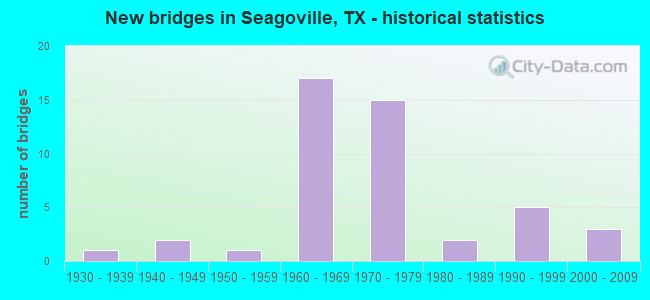
- New bridges - historical statistics
- 11930-1939
- 21940-1949
- 11950-1959
- 171960-1969
- 151970-1979
- 21980-1989
- 51990-1999
- 32000-2009

- Reconstructed bridges - Historical Statistics
- 21960-1969
- 01970-1979
- 11980-1989
- 01990-1999
- 02000-2009
- 02010-2019
- 12020-2022


- Bridge Condition - Deck
- 4.3%Very good
- 56.5%Good
- 39.1%Satisfactory

- Bridge Condition - Superstructure
- 21.7%Very good
- 52.2%Good
- 17.4%Satisfactory
- 4.3%Fair
- 4.3%Poor

- Bridge Condition - Substructure
- 4.3%Very good
- 21.7%Good
- 60.9%Satisfactory
- 8.7%Fair
- 4.3%Poor

- Bridge Condition - Channel
- 4.5%Very good
- 36.4%Good
- 45.5%Satisfactory
- 13.6%Fair

- Bridge Condition - Culverts
- 40.0%Good
- 60.0%Satisfactory
Find on map >> Show street view
Structure Number: 180570019702087, Location: 3.30 MI SE OF IH 20 (Lat: 32.670467, Lng: -96.590897), Route carried "on" structure: ServiceUS 175, Year Built: 1938, Status: Open, Structure Length: 3.17m (10.40ft), Average Daily Traffic: 790 (year 2015), Truck Traffic: 7%, Average Future Daily Traffic: 1,100 (year 2035), Design Load: H 15, Features Intersected: GOFF BRANCH
Minimum Vertical Clearance: 30+ m (98+ ft), Kilometerpoint: 18.361, Lanes on structure: 2, Owner: State Highway Agency, Approaching Roadway Width: 9.1m (29.9ft), Material/Design: Concrete, Design/Construction: Tee Beam, Number Of Spans In Main Unit: 3, Length of Maximum Span: 10.7m (35.1ft), Curb-To-Curb Width: 7.3m (24.0ft), Out-to-Out Width: 8.6m (28.2ft)
Condition: Deck: Good, Superstructure: Fair, Substructure: Satisfactory, Channel: Good, Operating Rating: 52.6 metric tons, Method Used To Determine Operating Rating: Load Factor (LF), Inventory Rating: 31.7 metric tons, Method Used To Determine Inventory Rating: Load Factor (LF), Structural Evaluation: Somewhat better than minimum adequacy, Deck Geometry: High priority of replacement, Waterway Adequacy: Better than present minimum criteria, Approach Roadway Alignment: Equal to present desirable criteria, Length Of Structure Improvement: 3.17m (10.40ft), Designated Inspection Frequency: Every 24 months, Inspection Date: April 2020, Bridge Improvement Cost: $5,000, Roadway Improvement Cost: $1,000, Total Project Cost: $6,000, Deck Structure Type: Concrete Cast-file-Place, Wearing Surface/Protective System: Wearing Surface: Bituminous
Find on map >> Show street view
Structure Number: 180570019702092, Location: 7.35 MI SE OF IH 20 (Lat: 32.645508, Lng: -96.525850), Route carried "on" structure: US 175, Year Built: 1948, Year Reconstructed: 1971, Status: Open, Structure Length: 3.05m (10.01ft), Average Daily Traffic: 18,060 (year 2015), Truck Traffic: 8%, Average Future Daily Traffic: 25,290 (year 2035), Design Load: H 20, Features Intersected: E FORK TRINITY RIV TRIB
Minimum Vertical Clearance: 30+ m (98+ ft), Kilometerpoint: 25.040, Lanes on structure: 2, Owner: State Highway Agency, Approaching Roadway Width: 12.2m (40.0ft), Material/Design: Concrete, Design/Construction: Slab, Number Of Spans In Main Unit: 4, Length of Maximum Span: 7.6m (24.9ft), Curb-To-Curb Width: 13.1m (43.0ft), Out-to-Out Width: 13.7m (44.9ft)
Condition: Deck: Satisfactory, Superstructure: Satisfactory, Substructure: Satisfactory, Channel: Satisfactory, Operating Rating: 52.6 metric tons, Method Used To Determine Operating Rating: Load Factor (LF), Inventory Rating: 31.7 metric tons, Method Used To Determine Inventory Rating: Load Factor (LF), Structural Evaluation: Equal to present minimum criteria, Deck Geometry: Superior to present desirable criteria, Waterway Adequacy: Equal to present minimum criteria, Approach Roadway Alignment: Equal to present desirable criteria, Designated Inspection Frequency: Every 24 months, Inspection Date: April 2020, Deck Structure Type: Concrete Cast-file-Place, Wearing Surface/Protective System: Wearing Surface: Bituminous
Find on map >> Show street view
Structure Number: 180570019702124, Location: 3.90 MI SE OF IH 20 (Lat: 32.662006, Lng: -96.574564), Route carried "on" structure: US 175, Year Built: 1961, Year Reconstructed: 1972, Status: Open, Structure Length: 0.82m (2.69ft), Average Daily Traffic: 51,652 (year 2020), Truck Traffic: 9%, Average Future Daily Traffic: 61,210 (year 2035), Features Intersected: DRAIN
Minimum Vertical Clearance: 30+ m (98+ ft), Kilometerpoint: 20.221, Lanes on structure: 9, Owner: State Highway Agency, Approaching Roadway Width: 39.0m (128.0ft), Skew: 39 degrees, Material/Design: Concrete, Design/Construction: Culvert, Number Of Spans In Main Unit: 4, Length of Maximum Span: 1.8m (5.9ft)
Condition: Channel: Satisfactory, Culverts: Satisfactory, Operating Rating: 39.9 metric tons, Method Used To Determine Operating Rating: Load Factor (LF), Inventory Rating: 23.6 metric tons, Method Used To Determine Inventory Rating: Load Factor (LF), Structural Evaluation: Somewhat better than minimum adequacy, Waterway Adequacy: Equal to present minimum criteria, Approach Roadway Alignment: Equal to present desirable criteria, Designated Inspection Frequency: Every 24 months, Inspection Date: March 2020
Find on map >> Show street view
Structure Number: 180570019702151, Location: 4.30 MI SE OF IH 20 (Lat: 32.661106, Lng: -96.571303), Route carried "on" structure: City street , Year Built: 1964, Status: Open, Structure Length: 5.40m (17.72ft), Average Daily Traffic: 4,882 (year 2019), Average Future Daily Traffic: 10,765 (year 2035), Design Load: H 20, Features Intersected: US 175, Facility Carried by Structure: SIMONDS RD
Minimum Vertical Clearance: 30+ m (98+ ft), Kilometerpoint: 0.805, Lanes on structure: 2, Lanes under structure: 4, Owner: State Highway Agency, Approaching Roadway Width: 14.6m (47.9ft), Material/Design: Prestressed concrete, Design/Construction: Stringer/Multi-beam, Number Of Spans In Main Unit: 2, Number Of Approach Spans: 2, Length of Maximum Span: 16.8m (55.1ft), Curb or Sidewalk Widths: Left: 1.8m (5.9ft), Right: 1.8m (5.9ft), Curb-To-Curb Width: 14.6m (47.9ft), Out-to-Out Width: 18.7m (61.4ft)
Condition: Deck: Satisfactory, Superstructure: Satisfactory, Substructure: Satisfactory, Operating Rating: 32.7 metric tons, Method Used To Determine Operating Rating: Assigned ratings based on Allowable Stress Design (ASD) reported in metric tons, Inventory Rating: 24.5 metric tons, Method Used To Determine Inventory Rating: Assigned ratings based on Allowable Stress Design (ASD) reported in metric tons, Structural Evaluation: Equal to present minimum criteria, Deck Geometry: Superior to present desirable criteria, Underclear: High priority of corrective action, Approach Roadway Alignment: Equal to present desirable criteria, Length Of Structure Improvement: 5.40m (17.72ft), Designated Inspection Frequency: Every 24 months, Inspection Date: April 2020, Bridge Improvement Cost: $17,000, Roadway Improvement Cost: $4,000, Total Project Cost: $21,000, Deck Structure Type: Concrete Cast-file-Place
Find on map >> Show street view
Structure Number: 180570019702152, Location: 5.25 MI SE OF IH 20 (Lat: 32.654933, Lng: -96.557453), Route carried "on" structure: US 175, Year Built: 1964, Status: Open, Structure Length: 5.49m (18.01ft), Average Daily Traffic: 21,860 (year 2015), Truck Traffic: 9%, Average Future Daily Traffic: 30,600 (year 2035), Design Load: HS 20, Features Intersected: SEAGOVILLE RD
Minimum Vertical Clearance: 30+ m (98+ ft), Kilometerpoint: 21.902, Lanes on structure: 2, Lanes under structure: 4, Owner: State Highway Agency, Approaching Roadway Width: 11.6m (38.1ft), Material/Design: Prestressed concrete, Design/Construction: Stringer/Multi-beam, Number Of Spans In Main Unit: 4, Length of Maximum Span: 13.7m (44.9ft), Curb-To-Curb Width: 11.6m (38.1ft), Out-to-Out Width: 12.7m (41.7ft)
Condition: Deck: Satisfactory, Superstructure: Good, Substructure: Satisfactory, Operating Rating: 44.4 metric tons, Method Used To Determine Operating Rating: Assigned ratings based on Allowable Stress Design (ASD) reported in metric tons, Inventory Rating: 32.7 metric tons, Method Used To Determine Inventory Rating: Assigned ratings based on Allowable Stress Design (ASD) reported in metric tons, Structural Evaluation: Equal to present minimum criteria, Deck Geometry: Equal to present minimum criteria, Underclear: Equal to present minimum criteria, Approach Roadway Alignment: Equal to present desirable criteria, Designated Inspection Frequency: Every 24 months, Inspection Date: April 2020, Deck Structure Type: Concrete Cast-file-Place
Find on map >> Show street view
Structure Number: 180570019702153, Location: 5.25 MI SE OF IH 20 (Lat: 32.654881, Lng: -96.557983), Route carried "on" structure: US 175, Year Built: 1964, Status: Open, Structure Length: 5.49m (18.01ft), Average Daily Traffic: 21,860 (year 2015), Truck Traffic: 9%, Average Future Daily Traffic: 30,600 (year 2035), Design Load: HS 20, Features Intersected: SEAGOVILLE RD
Minimum Vertical Clearance: 30+ m (98+ ft), Kilometerpoint: 21.902, Lanes on structure: 2, Lanes under structure: 4, Owner: State Highway Agency, Approaching Roadway Width: 11.6m (38.1ft), Material/Design: Prestressed concrete, Design/Construction: Stringer/Multi-beam, Number Of Spans In Main Unit: 4, Length of Maximum Span: 13.7m (44.9ft), Curb-To-Curb Width: 11.6m (38.1ft), Out-to-Out Width: 12.7m (41.7ft)
Condition: Deck: Satisfactory, Superstructure: Good, Substructure: Satisfactory, Operating Rating: 44.4 metric tons, Method Used To Determine Operating Rating: Assigned ratings based on Allowable Stress Design (ASD) reported in metric tons, Inventory Rating: 32.7 metric tons, Method Used To Determine Inventory Rating: Assigned ratings based on Allowable Stress Design (ASD) reported in metric tons, Structural Evaluation: Equal to present minimum criteria, Deck Geometry: Equal to present minimum criteria, Underclear: Superior to present desirable criteria, Approach Roadway Alignment: Equal to present desirable criteria, Designated Inspection Frequency: Every 24 months, Inspection Date: April 2020, Deck Structure Type: Concrete Cast-file-Place
Find on map >> Show street view
Structure Number: 180570019702154, Location: 6.10 MI SE OF IH 20 (Lat: 32.650103, Lng: -96.545447), Route carried "on" structure: US 175, Year Built: 1964, Status: Open, Structure Length: 4.97m (16.31ft), Average Daily Traffic: 18,060 (year 2015), Truck Traffic: 8%, Average Future Daily Traffic: 25,290 (year 2035), Design Load: HS 20, Features Intersected: HALL ST
Minimum Vertical Clearance: 30+ m (98+ ft), Kilometerpoint: 23.144, Lanes on structure: 2, Lanes under structure: 4, Owner: State Highway Agency, Approaching Roadway Width: 11.6m (38.1ft), Skew: 2 degrees, Material/Design: Prestressed concrete, Design/Construction: Stringer/Multi-beam, Number Of Spans In Main Unit: 2, Number Of Approach Spans: 2, Length of Maximum Span: 14.6m (47.9ft), Curb-To-Curb Width: 11.6m (38.1ft), Out-to-Out Width: 12.7m (41.7ft)
Condition: Deck: Good, Superstructure: Good, Substructure: Satisfactory, Operating Rating: 44.4 metric tons, Method Used To Determine Operating Rating: Assigned ratings based on Allowable Stress Design (ASD) reported in metric tons, Inventory Rating: 32.7 metric tons, Method Used To Determine Inventory Rating: Assigned ratings based on Allowable Stress Design (ASD) reported in metric tons, Structural Evaluation: Equal to present minimum criteria, Deck Geometry: Equal to present minimum criteria, Underclear: Equal to present minimum criteria, Approach Roadway Alignment: Equal to present desirable criteria, Designated Inspection Frequency: Every 24 months, Inspection Date: April 2020, Deck Structure Type: Concrete Cast-file-Place, Wearing Surface/Protective System: Wearing Surface: Bituminous
Find on map >> Show street view
Structure Number: 180570019702155, Location: 6.10 MI SE OF IH 20 (Lat: 32.650111, Lng: -96.546131), Route carried "on" structure: US 175, Year Built: 1964, Status: Open, Structure Length: 4.97m (16.31ft), Average Daily Traffic: 18,060 (year 2015), Truck Traffic: 8%, Average Future Daily Traffic: 25,290 (year 2035), Design Load: HS 20, Features Intersected: HALL ST
Minimum Vertical Clearance: 30+ m (98+ ft), Kilometerpoint: 23.144, Lanes on structure: 2, Lanes under structure: 4, Owner: State Highway Agency, Approaching Roadway Width: 11.6m (38.1ft), Skew: 2 degrees, Material/Design: Prestressed concrete, Design/Construction: Stringer/Multi-beam, Number Of Spans In Main Unit: 2, Number Of Approach Spans: 2, Length of Maximum Span: 14.6m (47.9ft), Curb-To-Curb Width: 11.6m (38.1ft), Out-to-Out Width: 12.7m (41.7ft)
Condition: Deck: Good, Superstructure: Good, Substructure: Satisfactory, Operating Rating: 44.4 metric tons, Method Used To Determine Operating Rating: Assigned ratings based on Allowable Stress Design (ASD) reported in metric tons, Inventory Rating: 32.7 metric tons, Method Used To Determine Inventory Rating: Assigned ratings based on Allowable Stress Design (ASD) reported in metric tons, Structural Evaluation: Equal to present minimum criteria, Deck Geometry: Equal to present minimum criteria, Underclear: Equal to present minimum criteria, Approach Roadway Alignment: Equal to present desirable criteria, Designated Inspection Frequency: Every 24 months, Inspection Date: April 2020, Deck Structure Type: Concrete Cast-file-Place, Wearing Surface/Protective System: Wearing Surface: Bituminous
Find on map >> Show street view
Structure Number: 180570019702156, Location: 6.75 MI SE OF IH 20 (Lat: 32.647231, Lng: -96.533778), Route carried "on" structure: US 175, Year Built: 1964, Status: Open, Structure Length: 4.91m (16.11ft), Average Daily Traffic: 18,060 (year 2015), Truck Traffic: 8%, Average Future Daily Traffic: 25,290 (year 2035), Design Load: HS 20, Features Intersected: MALLOY BRIDGE RD
Minimum Vertical Clearance: 30+ m (98+ ft), Kilometerpoint: 24.293, Lanes on structure: 2, Lanes under structure: 4, Owner: State Highway Agency, Approaching Roadway Width: 11.6m (38.1ft), Skew: 3 degrees, Material/Design: Prestressed concrete, Design/Construction: Stringer/Multi-beam, Number Of Spans In Main Unit: 3, Length of Maximum Span: 19.2m (63.0ft), Curb-To-Curb Width: 11.6m (38.1ft), Out-to-Out Width: 12.7m (41.7ft)
Condition: Deck: Good, Superstructure: Good, Substructure: Satisfactory, Operating Rating: 44.4 metric tons, Method Used To Determine Operating Rating: Assigned ratings based on Allowable Stress Design (ASD) reported in metric tons, Inventory Rating: 32.7 metric tons, Method Used To Determine Inventory Rating: Assigned ratings based on Allowable Stress Design (ASD) reported in metric tons, Structural Evaluation: Equal to present minimum criteria, Deck Geometry: Equal to present minimum criteria, Underclear: High priority of corrective action, Approach Roadway Alignment: Equal to present desirable criteria, Designated Inspection Frequency: Every 24 months, Inspection Date: April 2020, Deck Structure Type: Concrete Cast-file-Place, Wearing Surface/Protective System: Wearing Surface: Bituminous
Find on map >> Show street view
Structure Number: 180570019702157, Location: 6.75 MI SE OF IH 20 (Lat: 32.647086, Lng: -96.534492), Route carried "on" structure: US 175, Year Built: 1964, Status: Open, Structure Length: 4.91m (16.11ft), Average Daily Traffic: 18,060 (year 2015), Truck Traffic: 8%, Average Future Daily Traffic: 25,290 (year 2035), Design Load: HS 20, Features Intersected: MALLOY BRIDGE RD
Minimum Vertical Clearance: 30+ m (98+ ft), Kilometerpoint: 24.282, Lanes on structure: 2, Lanes under structure: 4, Owner: State Highway Agency, Approaching Roadway Width: 11.6m (38.1ft), Skew: 3 degrees, Material/Design: Prestressed concrete, Design/Construction: Stringer/Multi-beam, Number Of Spans In Main Unit: 3, Length of Maximum Span: 19.2m (63.0ft), Curb-To-Curb Width: 11.6m (38.1ft), Out-to-Out Width: 12.7m (41.7ft)
Condition: Deck: Satisfactory, Superstructure: Satisfactory, Substructure: Satisfactory, Operating Rating: 44.4 metric tons, Method Used To Determine Operating Rating: Assigned ratings based on Allowable Stress Design (ASD) reported in metric tons, Inventory Rating: 32.7 metric tons, Method Used To Determine Inventory Rating: Assigned ratings based on Allowable Stress Design (ASD) reported in metric tons, Structural Evaluation: Equal to present minimum criteria, Deck Geometry: Equal to present minimum criteria, Underclear: High priority of corrective action, Approach Roadway Alignment: Equal to present desirable criteria, Designated Inspection Frequency: Every 24 months, Inspection Date: April 2020, Deck Structure Type: Concrete Cast-file-Place, Wearing Surface/Protective System: Wearing Surface: Bituminous
Find on map >> Show street view
Structure Number: 180570019702171, Location: 7.00 MI SE OF IH 20 (Lat: 32.645783, Lng: -96.525531), Route carried "on" structure: ServiceUS 175, Year Built: 1971, Status: Open, Structure Length: 1.31m (4.30ft), Average Daily Traffic: 4,590 (year 2015), Truck Traffic: 8%, Average Future Daily Traffic: 6,430 (year 2035), Features Intersected: E FORK TRINITY RIV TRIB
Minimum Vertical Clearance: 30+ m (98+ ft), Kilometerpoint: 25.112, Lanes on structure: 2, Owner: State Highway Agency, Approaching Roadway Width: 10.4m (34.1ft), Material/Design: Concrete, Design/Construction: Culvert, Number Of Spans In Main Unit: 4, Length of Maximum Span: 3.0m (9.8ft)
Condition: Channel: Satisfactory, Culverts: Satisfactory, Operating Rating: 32.7 metric tons, Method Used To Determine Operating Rating: Field evaluation and documented engineering judgment, Inventory Rating: 24.5 metric tons, Method Used To Determine Inventory Rating: Field evaluation and documented engineering judgment, Structural Evaluation: Equal to present minimum criteria, Waterway Adequacy: Better than present minimum criteria, Approach Roadway Alignment: Equal to present desirable criteria, Designated Inspection Frequency: Every 24 months, Inspection Date: April 2020
Find on map >> Show street view
Structure Number: 180570019702172, Location: 7.35 MI SE OF IH 20 (Lat: 32.645992, Lng: -96.525500), Route carried "on" structure: US 175, Year Built: 1971, Status: Open, Structure Length: 3.08m (10.10ft), Average Daily Traffic: 18,060 (year 2015), Truck Traffic: 8%, Average Future Daily Traffic: 25,290 (year 2035), Design Load: HS 20, Features Intersected: E FORK TRINITY RIV TRIB
Minimum Vertical Clearance: 30+ m (98+ ft), Kilometerpoint: 25.040, Lanes on structure: 2, Owner: State Highway Agency, Approaching Roadway Width: 12.2m (40.0ft), Material/Design: Concrete, Design/Construction: Stringer/Multi-beam, Number Of Spans In Main Unit: 3, Length of Maximum Span: 12.2m (40.0ft), Curb-To-Curb Width: 12.8m (42.0ft), Out-to-Out Width: 13.4m (44.0ft)
Condition: Deck: Good, Superstructure: Good, Substructure: Good, Channel: Satisfactory, Operating Rating: 68.0 metric tons, Method Used To Determine Operating Rating: Load Factor (LF), Inventory Rating: 40.8 metric tons, Method Used To Determine Inventory Rating: Load Factor (LF), Structural Evaluation: Better than present minimum criteria, Deck Geometry: Equal to present desirable criteria, Waterway Adequacy: Equal to present minimum criteria, Approach Roadway Alignment: Equal to present desirable criteria, Designated Inspection Frequency: Every 24 months, Inspection Date: April 2020, Deck Structure Type: Concrete Cast-file-Place, Wearing Surface/Protective System: Wearing Surface: Bituminous
Find on map >> Show street view
Structure Number: 180570019702173, Location: 7.00 MI SE OF IH 20 (Lat: 32.645322, Lng: -96.525894), Route carried "on" structure: ServiceUS 175, Year Built: 1971, Status: Open, Structure Length: 1.31m (4.30ft), Average Daily Traffic: 4,900 (year 2015), Truck Traffic: 9%, Average Future Daily Traffic: 6,860 (year 2035), Features Intersected: E FORK TRINITY RIV TRIB
Minimum Vertical Clearance: 30+ m (98+ ft), Kilometerpoint: 25.112, Lanes on structure: 2, Owner: State Highway Agency, Approaching Roadway Width: 10.4m (34.1ft), Material/Design: Concrete, Design/Construction: Culvert, Number Of Spans In Main Unit: 4, Length of Maximum Span: 3.0m (9.8ft)
Condition: Channel: Satisfactory, Culverts: Satisfactory, Operating Rating: 32.7 metric tons, Method Used To Determine Operating Rating: Field evaluation and documented engineering judgment, Inventory Rating: 24.5 metric tons, Method Used To Determine Inventory Rating: Field evaluation and documented engineering judgment, Structural Evaluation: Equal to present minimum criteria, Waterway Adequacy: Better than present minimum criteria, Approach Roadway Alignment: Equal to present desirable criteria, Designated Inspection Frequency: Every 24 months, Inspection Date: April 2020
Find on map >> Show street view
Structure Number: 180570019702184, Location: 2.95 MI SE OF IH 20 (Lat: 32.672806, Lng: -96.595608), Route carried "on" structure: City street , Year Built: 1972, Status: Open, Structure Length: 5.06m (16.60ft), Average Daily Traffic: 4,342 (year 2015), Average Future Daily Traffic: 5,420 (year 2035), Design Load: HS 20, Features Intersected: US 175, Facility Carried by Structure: WOODY RD
Minimum Vertical Clearance: 30+ m (98+ ft), Kilometerpoint: 0.805, Lanes on structure: 4, Lanes under structure: 4, Owner: State Highway Agency, Approaching Roadway Width: 14.6m (47.9ft), Skew: 1 degrees, Material/Design: Prestressed concrete, Design/Construction: Stringer/Multi-beam, Number Of Spans In Main Unit: 2, Length of Maximum Span: 25.3m (83.0ft), Curb-To-Curb Width: 14.6m (47.9ft), Out-to-Out Width: 15.2m (49.9ft)
Condition: Deck: Good, Superstructure: Good, Substructure: Satisfactory, Operating Rating: 54.4 metric tons, Method Used To Determine Operating Rating: Assigned rating based on Load Factor Design (LFD) reported in metric tons, Inventory Rating: 32.7 metric tons, Method Used To Determine Inventory Rating: Assigned rating based on Load Factor Design (LFD) reported in metric tons, Structural Evaluation: Equal to present minimum criteria, Deck Geometry: High priority of replacement, Underclear: Equal to present minimum criteria, Approach Roadway Alignment: Equal to present desirable criteria, Length Of Structure Improvement: 5.06m (16.60ft), Designated Inspection Frequency: Every 24 months, Inspection Date: April 2020, Bridge Improvement Cost: $16,000, Roadway Improvement Cost: $4,000, Total Project Cost: $20,000, Deck Structure Type: Concrete Cast-file-Place
Find on map >> Show street view
Structure Number: 180570019702185, Location: 3.30 MI SE OF IH 20 (Lat: 32.670619, Lng: -96.590806), Route carried "on" structure: US 175, Year Built: 1972, Status: Open, Structure Length: 2.77m (9.09ft), Average Daily Traffic: 29,900 (year 2015), Truck Traffic: 9%, Average Future Daily Traffic: 41,870 (year 2035), Design Load: HS 20, Features Intersected: GOFF BRANCH
Minimum Vertical Clearance: 30+ m (98+ ft), Kilometerpoint: 18.364, Lanes on structure: 2, Owner: State Highway Agency, Approaching Roadway Width: 11.6m (38.1ft), Material/Design: Concrete, Design/Construction: Stringer/Multi-beam, Number Of Spans In Main Unit: 3, Length of Maximum Span: 9.1m (29.9ft), Curb-To-Curb Width: 12.8m (42.0ft), Out-to-Out Width: 13.5m (44.3ft)
Condition: Deck: Satisfactory, Superstructure: Good, Substructure: Good, Channel: Satisfactory, Operating Rating: 68.0 metric tons, Method Used To Determine Operating Rating: Load Factor (LF), Inventory Rating: 40.8 metric tons, Method Used To Determine Inventory Rating: Load Factor (LF), Structural Evaluation: Better than present minimum criteria, Deck Geometry: Equal to present desirable criteria, Waterway Adequacy: Equal to present minimum criteria, Approach Roadway Alignment: Equal to present desirable criteria, Designated Inspection Frequency: Every 24 months, Inspection Date: April 2020, Deck Structure Type: Concrete Cast-file-Place
Find on map >> Show street view
Structure Number: 180570019702187, Location: 3.50 MI SE OF IH 20 (Lat: 32.668158, Lng: -96.585508), Route carried "on" structure: US 175, Year Built: 1972, Status: Open, Structure Length: 5.18m (16.99ft), Average Daily Traffic: 29,900 (year 2015), Truck Traffic: 9%, Average Future Daily Traffic: 41,870 (year 2035), Design Load: HS 20, Features Intersected: STARK RD
Minimum Vertical Clearance: 30+ m (98+ ft), Kilometerpoint: 18.932, Lanes on structure: 2, Lanes under structure: 2, Owner: State Highway Agency, Approaching Roadway Width: 12.8m (42.0ft), Skew: 1 degrees, Material/Design: Prestressed concrete, Design/Construction: Stringer/Multi-beam, Number Of Spans In Main Unit: 1, Number Of Approach Spans: 2, Length of Maximum Span: 21.3m (69.9ft), Curb-To-Curb Width: 12.3m (40.4ft), Out-to-Out Width: 13.4m (44.0ft)
Condition: Deck: Good, Superstructure: Very good, Substructure: Satisfactory, Operating Rating: 54.4 metric tons, Method Used To Determine Operating Rating: Assigned rating based on Load Factor Design (LFD) reported in metric tons, Inventory Rating: 32.7 metric tons, Method Used To Determine Inventory Rating: Assigned rating based on Load Factor Design (LFD) reported in metric tons, Structural Evaluation: Equal to present minimum criteria, Deck Geometry: Better than present minimum criteria, Underclear: Superior to present desirable criteria, Approach Roadway Alignment: Equal to present desirable criteria, Designated Inspection Frequency: Every 24 months, Inspection Date: April 2020, Deck Structure Type: Concrete Cast-file-Place
Find on map >> Show street view
Structure Number: 180570019702188, Location: 3.50 MI SE OF IH 20 (Lat: 32.668153, Lng: -96.584814), Route carried "on" structure: US 175, Year Built: 1972, Status: Open, Structure Length: 5.18m (16.99ft), Average Daily Traffic: 29,900 (year 2015), Truck Traffic: 9%, Average Future Daily Traffic: 41,870 (year 2035), Design Load: HS 20, Features Intersected: STARK RD
Minimum Vertical Clearance: 30+ m (98+ ft), Kilometerpoint: 18.932, Lanes on structure: 2, Lanes under structure: 2, Owner: State Highway Agency, Approaching Roadway Width: 12.8m (42.0ft), Skew: 1 degrees, Material/Design: Prestressed concrete, Design/Construction: Stringer/Multi-beam, Number Of Spans In Main Unit: 1, Number Of Approach Spans: 2, Length of Maximum Span: 21.3m (69.9ft), Curb-To-Curb Width: 12.3m (40.4ft), Out-to-Out Width: 13.4m (44.0ft)
Condition: Deck: Good, Superstructure: Very good, Substructure: Satisfactory, Operating Rating: 54.4 metric tons, Method Used To Determine Operating Rating: Assigned rating based on Load Factor Design (LFD) reported in metric tons, Inventory Rating: 32.7 metric tons, Method Used To Determine Inventory Rating: Assigned rating based on Load Factor Design (LFD) reported in metric tons, Structural Evaluation: Equal to present minimum criteria, Deck Geometry: Better than present minimum criteria, Underclear: Better than present minimum criteria, Approach Roadway Alignment: Equal to present desirable criteria, Designated Inspection Frequency: Every 24 months, Inspection Date: April 2020, Deck Structure Type: Concrete Cast-file-Place
Find on map >> Show street view
Structure Number: 180570AA0095001, Location: 0.25 MI SE OF SIMONDS RD (Lat: 32.638472, Lng: -96.590881), Route carried "on" structure: County highway , Year Built: 1945, Year Reconstructed: 1987, Status: Open, Structure Length: 0.67m (2.20ft), Average Daily Traffic: 614 (year 2019), Average Future Daily Traffic: 1,200 (year 2031), Features Intersected: HICKORY CREEK TRIB, Facility Carried by Structure: BOWERS RD
Minimum Vertical Clearance: 30+ m (98+ ft), Kilometerpoint: 0.402, Lanes on structure: 2, Owner: County Highway Agency, Approaching Roadway Width: 7.9m (25.9ft), Material/Design: Concrete, Design/Construction: Culvert, Number Of Spans In Main Unit: 3, Length of Maximum Span: 2.1m (6.9ft), Curb-To-Curb Width: 13.4m (44.0ft), Out-to-Out Width: 13.8m (45.3ft)
Condition: Channel: Good, Culverts: Satisfactory, Operating Rating: 32.7 metric tons, Method Used To Determine Operating Rating: Field evaluation and documented engineering judgment, Inventory Rating: 24.5 metric tons, Method Used To Determine Inventory Rating: Field evaluation and documented engineering judgment, Structural Evaluation: Equal to present minimum criteria, Deck Geometry: Superior to present desirable criteria, Waterway Adequacy: Better than present minimum criteria, Approach Roadway Alignment: Equal to present desirable criteria, Designated Inspection Frequency: Every 24 months, Inspection Date: Febuary 2021, Deck Structure Type: Concrete Cast-file-Place, Wearing Surface/Protective System: Wearing Surface: Bituminous
Find on map >> Show street view
Structure Number: 180570AA0222004, Location: 1.1 MI NE OF BILINDSAY RD (Lat: 32.618097, Lng: -96.560483), Route carried "on" structure: County highway , Year Built: 1965, Status: Posted for load, Structure Length: 4.02m (13.19ft), Average Daily Traffic: 2,534 (year 2019), Truck Traffic: 15%, Average Future Daily Traffic: 4,000 (year 2031), Features Intersected: PARSONS SLOUGH, Facility Carried by Structure: MALLOY BRIDGE RD
Minimum Vertical Clearance: 30+ m (98+ ft), Kilometerpoint: 42.326, Lanes on structure: 2, Owner: County Highway Agency, Approaching Roadway Width: 7.3m (24.0ft), Material/Design: Concrete, Design/Construction: Tee Beam, Number Of Spans In Main Unit: 3, Length of Maximum Span: 13.4m (44.0ft), Curb-To-Curb Width: 7.9m (25.9ft), Out-to-Out Width: 8.9m (29.2ft)
Condition: Deck: Satisfactory, Superstructure: Poor, Substructure: Poor, Channel: Fair, Operating Rating: 32.7 metric tons, Method Used To Determine Operating Rating: Field evaluation and documented engineering judgment, Inventory Rating: 24.5 metric tons, Method Used To Determine Inventory Rating: Field evaluation and documented engineering judgment, Structural Evaluation: Meets minimum limits, Deck Geometry: High priority of corrective action, Waterway Adequacy: Equal to present minimum criteria, Approach Roadway Alignment: Equal to present desirable criteria, Bridge Posting: Required (Relationship of Operating Rating to Maximum Legal Load: 10.0 - 19.9% below), Length Of Structure Improvement: 4.02m (13.19ft), Designated Inspection Frequency: Every 24 months, Inspection Date: April 2021, Bridge Improvement Cost: $7,000, Roadway Improvement Cost: $2,000, Total Project Cost: $9,000, Deck Structure Type: Concrete Cast-file-Place, Wearing Surface/Protective System: Wearing Surface: Bituminous
Find on map >> Show street view
Structure Number: 180570AA0455001, Location: 0.25 MI SW OF KAUFMAN CO (Lat: 32.664997, Lng: -96.524239), Route carried "on" structure: City street , Year Built: 1985, Status: Open, Structure Length: 6.49m (21.29ft), Average Daily Traffic: 320 (year 2011), Average Future Daily Traffic: 500 (year 2031), Features Intersected: E FORK TRINITY RIVER, Facility Carried by Structure: MALLOY BRIDGE RD
Minimum Vertical Clearance: 30+ m (98+ ft), Kilometerpoint: 0.402, Lanes on structure: 2, Owner: City or Municipal Highway Agency, Approaching Roadway Width: 7.3m (24.0ft), Skew: 1 degrees, Material/Design: Prestressed concrete, Design/Construction: Stringer/Multi-beam, Number Of Spans In Main Unit: 2, Length of Maximum Span: 32.0m (105.0ft), Curb-To-Curb Width: 8.5m (27.9ft), Out-to-Out Width: 9.2m (30.2ft)
Condition: Deck: Satisfactory, Superstructure: Good, Substructure: Satisfactory, Channel: Fair, Operating Rating: 32.7 metric tons, Method Used To Determine Operating Rating: Field evaluation and documented engineering judgment, Inventory Rating: 24.5 metric tons, Method Used To Determine Inventory Rating: Field evaluation and documented engineering judgment, Structural Evaluation: Equal to present minimum criteria, Deck Geometry: Equal to present minimum criteria, Waterway Adequacy: Meets minimum limits, Approach Roadway Alignment: Equal to present desirable criteria, Designated Inspection Frequency: Every 24 months, Inspection Date: January 2021, Deck Structure Type: Concrete Cast-file-Place
Find on map >> Show street view
Structure Number: 180570AA0455002, Location: 1.20 MI NE OF US 175 (Lat: 32.663236, Lng: -96.526347), Route carried "on" structure: City street , Year Built: 1985, Status: Open, Structure Length: 1.16m (3.81ft), Average Daily Traffic: 320 (year 2011), Average Future Daily Traffic: 500 (year 2031), Features Intersected: E FK TRINITY RIV REL, Facility Carried by Structure: MALLOY BRIDGE RD
Minimum Vertical Clearance: 30+ m (98+ ft), Kilometerpoint: 0.435, Lanes on structure: 2, Owner: City or Municipal Highway Agency, Approaching Roadway Width: 7.3m (24.0ft), Material/Design: Concrete, Design/Construction: Culvert, Number Of Spans In Main Unit: 4, Length of Maximum Span: 2.7m (8.9ft), Curb-To-Curb Width: 8.5m (27.9ft), Out-to-Out Width: 9.1m (29.9ft)
Condition: Channel: Satisfactory, Culverts: Satisfactory, Operating Rating: 32.7 metric tons, Method Used To Determine Operating Rating: Field evaluation and documented engineering judgment, Inventory Rating: 24.5 metric tons, Method Used To Determine Inventory Rating: Field evaluation and documented engineering judgment, Structural Evaluation: Equal to present minimum criteria, Deck Geometry: Equal to present minimum criteria, Waterway Adequacy: Meets minimum limits, Approach Roadway Alignment: Equal to present desirable criteria, Designated Inspection Frequency: Every 24 months, Inspection Date: Febuary 2021, Deck Structure Type: Concrete Cast-file-Place
Find on map >> Show street view
Structure Number: 180570AA0650003, Location: 0.8 MI NE OF BELT LINE RD (Lat: 32.632250, Lng: -96.602414), Route carried "on" structure: County highway , Year Built: 1954, Status: Open, Structure Length: 5.85m (19.19ft), Average Daily Traffic: 680 (year 2020), Truck Traffic: 10%, Average Future Daily Traffic: 1,000 (year 2031), Features Intersected: HICKORY CREEK, Facility Carried by Structure: SIMONDS RD
Minimum Vertical Clearance: 30+ m (98+ ft), Kilometerpoint: 1.239, Lanes on structure: 2, Owner: County Highway Agency, Approaching Roadway Width: 6.7m (22.0ft), Skew: 2 degrees, Material/Design: Concrete continuous, Design/Construction: Slab, Number Of Spans In Main Unit: 7, Length of Maximum Span: 9.1m (29.9ft), Curb-To-Curb Width: 7.9m (25.9ft), Out-to-Out Width: 8.9m (29.2ft)
Condition: Deck: Satisfactory, Superstructure: Satisfactory, Substructure: Fair, Channel: Good, Operating Rating: 32.7 metric tons, Method Used To Determine Operating Rating: Field evaluation and documented engineering judgment, Inventory Rating: 24.5 metric tons, Method Used To Determine Inventory Rating: Field evaluation and documented engineering judgment, Structural Evaluation: Somewhat better than minimum adequacy, Deck Geometry: Somewhat better than minimum adequacy, Waterway Adequacy: Equal to present minimum criteria, Approach Roadway Alignment: Equal to present desirable criteria, Designated Inspection Frequency: Every 24 months, Inspection Date: Febuary 2021, Deck Structure Type: Concrete Cast-file-Place
Find on map >> Show street view
Structure Number: 180570L00225001, Location: 0.30 MI SE OF SIMONS RD (Lat: 32.666014, Lng: -96.551156), Route carried "on" structure: City street , Year Built: 1998, Year Reconstructed: 2020, Status: Open, Structure Length: 0.98m (3.22ft), Average Daily Traffic: 790 (year 2011), Truck Traffic: 2%, Average Future Daily Traffic: 1,000 (year 2031), Features Intersected: E FRK TRINITY RIVER TRIB, Facility Carried by Structure: FARMERS RD
Minimum Vertical Clearance: 30+ m (98+ ft), Kilometerpoint: 0.451, Lanes on structure: 2, Owner: City or Municipal Highway Agency, Approaching Roadway Width: 9.4m (30.8ft), Skew: 3 degrees, Material/Design: Concrete, Design/Construction: Culvert, Number Of Spans In Main Unit: 3, Length of Maximum Span: 2.4m (7.9ft)
Condition: Channel: Good, Culverts: Good, Operating Rating: 39.9 metric tons, Method Used To Determine Operating Rating: Load Factor (LF), Inventory Rating: 23.6 metric tons, Method Used To Determine Inventory Rating: Load Factor (LF), Structural Evaluation: Equal to present minimum criteria, Waterway Adequacy: Better than present minimum criteria, Approach Roadway Alignment: Equal to present desirable criteria, Designated Inspection Frequency: Every 24 months, Inspection Date: January 2021
Find on map >> Show street view
Structure Number: 180570L00390001, Location: 0.4 MI NW OF SIMONDS RD (Lat: 32.660169, Lng: -96.581425), Route carried "on" structure: City street , Year Built: 1960, Status: Open, Structure Length: 0.73m (2.40ft), Average Daily Traffic: 400 (year 2011), Average Future Daily Traffic: 700 (year 2031), Features Intersected: HICKORY CREEK TRIB, Facility Carried by Structure: KLEBERG RD
Minimum Vertical Clearance: 30+ m (98+ ft), Kilometerpoint: 0.595, Lanes on structure: 2, Owner: City or Municipal Highway Agency, Approaching Roadway Width: 6.7m (22.0ft), Skew: 3 degrees, Material/Design: Concrete, Design/Construction: Culvert, Number Of Spans In Main Unit: 2, Length of Maximum Span: 3.0m (9.8ft), Curb-To-Curb Width: 7.4m (24.3ft), Out-to-Out Width: 8.4m (27.6ft)
Condition: Channel: Satisfactory, Culverts: Satisfactory, Operating Rating: 32.7 metric tons, Method Used To Determine Operating Rating: Field evaluation and documented engineering judgment, Inventory Rating: 24.5 metric tons, Method Used To Determine Inventory Rating: Field evaluation and documented engineering judgment, Structural Evaluation: Equal to present minimum criteria, Deck Geometry: Somewhat better than minimum adequacy, Waterway Adequacy: Better than present minimum criteria, Approach Roadway Alignment: Equal to present desirable criteria, Designated Inspection Frequency: Every 24 months, Inspection Date: Febuary 2021, Deck Structure Type: Concrete Cast-file-Place, Wearing Surface/Protective System: Wearing Surface: Bituminous
Find on map >> Show street view
Structure Number: 180570L00650001, Location: 1.7 MI NE OF US 175 (Lat: 32.677100, Lng: -96.549842), Route carried "on" structure: City street , Year Built: 1998, Status: Open, Structure Length: 2.01m (6.59ft), Average Daily Traffic: 370 (year 2011), Average Future Daily Traffic: 500 (year 2031), Features Intersected: E FRK TRINITY RIVER TRIB, Facility Carried by Structure: SIMONDS RD
Minimum Vertical Clearance: 30+ m (98+ ft), Kilometerpoint: 2.800, Lanes on structure: 2, Owner: City or Municipal Highway Agency, Approaching Roadway Width: 7.3m (24.0ft), Material/Design: Prestressed concrete, Design/Construction: Stringer/Multi-beam, Number Of Spans In Main Unit: 1, Length of Maximum Span: 20.1m (65.9ft), Curb-To-Curb Width: 8.1m (26.6ft), Out-to-Out Width: 9.0m (29.5ft)
Condition: Deck: Very good, Superstructure: Good, Substructure: Very good, Channel: Good, Operating Rating: 32.7 metric tons, Method Used To Determine Operating Rating: Field evaluation and documented engineering judgment, Inventory Rating: 24.5 metric tons, Method Used To Determine Inventory Rating: Field evaluation and documented engineering judgment, Structural Evaluation: Equal to present minimum criteria, Deck Geometry: Somewhat better than minimum adequacy, Waterway Adequacy: Better than present minimum criteria, Approach Roadway Alignment: Equal to present minimum criteria, Designated Inspection Frequency: Every 24 months, Inspection Date: January 2021, Deck Structure Type: Concrete Precast Panels
Find on map >> Show street view
Structure Number: 180570LW2460001, Location: 0.40 MI SW of Kaufman St (Lat: 32.648906, Lng: -96.559811), Route carried "on" structure: City street , Year Built: 2007, Status: Open, Structure Length: 1.10m (3.61ft), Average Daily Traffic: 400 (year 2021), Truck Traffic: 2%, Average Future Daily Traffic: 520 (year 2041), Features Intersected: Draw, Facility Carried by Structure: Environmental Way
Minimum Vertical Clearance: 30+ m (98+ ft), Kilometerpoint: 0.644, Lanes on structure: 2, Owner: City or Municipal Highway Agency, Approaching Roadway Width: 10.7m (35.1ft), Skew: 2 degrees, Material/Design: Concrete, Design/Construction: Culvert, Number Of Spans In Main Unit: 5, Length of Maximum Span: 1.8m (5.9ft)
Condition: Channel: Good, Culverts: Good, Operating Rating: 32.7 metric tons, Method Used To Determine Operating Rating: Field evaluation and documented engineering judgment, Inventory Rating: 24.5 metric tons, Method Used To Determine Inventory Rating: Field evaluation and documented engineering judgment, Structural Evaluation: Equal to present minimum criteria, Waterway Adequacy: Better than present minimum criteria, Approach Roadway Alignment: Equal to present desirable criteria, Designated Inspection Frequency: Every 24 months, Inspection Date: June 2021
Find on map >> Show street view
Structure Number: 180570LW2491001, Location: 0.05 MI SE of Shannon Rd (Lat: 32.692839, Lng: -96.552689), Route carried "on" structure: City street , Year Built: 2006, Status: Open, Structure Length: 0.85m (2.79ft), Average Daily Traffic: 650 (year 2021), Average Future Daily Traffic: 850 (year 2041), Design Load: HS 20, Features Intersected: Draw, Facility Carried by Structure: Highland Meadows
Minimum Vertical Clearance: 30+ m (98+ ft), Kilometerpoint: 0.080, Lanes on structure: 2, Owner: City or Municipal Highway Agency, Approaching Roadway Width: 9.1m (29.9ft), Skew: 3 degrees, Material/Design: Concrete, Design/Construction: Culvert, Number Of Spans In Main Unit: 2, Length of Maximum Span: 3.0m (9.8ft), Curb-To-Curb Width: 9.1m (29.9ft), Out-to-Out Width: 21.1m (69.2ft)
Condition: Channel: Satisfactory, Culverts: Good, Operating Rating: 44.4 metric tons, Method Used To Determine Operating Rating: No rating analysis performed, Inventory Rating: 32.7 metric tons, Method Used To Determine Inventory Rating: No rating analysis performed, Structural Evaluation: Better than present minimum criteria, Deck Geometry: Equal to present minimum criteria, Waterway Adequacy: Better than present minimum criteria, Approach Roadway Alignment: Equal to present desirable criteria, Designated Inspection Frequency: Every 24 months, Inspection Date: June 2021, Deck Structure Type: Concrete Cast-file-Place, Wearing Surface/Protective System: Wearing Surface: Monolithic Concrete
Find on map >> Show street view
Structure Number: 180570T03409001, Location: 2.2 MI E of Simonds Rd (Lat: 32.644528, Lng: -96.565614), Route carried "on" structure: City street , Year Built: 2007, Status: Open, Structure Length: 0.91m (2.99ft), Average Daily Traffic: 420 (year 2021), Truck Traffic: 1%, Average Future Daily Traffic: 570 (year 2041), Features Intersected: Draw, Facility Carried by Structure: Bowers Rd
Minimum Vertical Clearance: 30+ m (98+ ft), Kilometerpoint: 3.541, Lanes on structure: 2, Owner: City or Municipal Highway Agency, Approaching Roadway Width: 6.7m (22.0ft), Skew: 2 degrees, Material/Design: Concrete, Design/Construction: Culvert, Number Of Spans In Main Unit: 4, Length of Maximum Span: 1.8m (5.9ft), Curb-To-Curb Width: 9.4m (30.8ft), Out-to-Out Width: 11.5m (37.7ft)
Condition: Channel: Good, Culverts: Good, Operating Rating: 32.7 metric tons, Method Used To Determine Operating Rating: Field evaluation and documented engineering judgment, Inventory Rating: 24.5 metric tons, Method Used To Determine Inventory Rating: Field evaluation and documented engineering judgment, Structural Evaluation: Equal to present minimum criteria, Deck Geometry: Equal to present minimum criteria, Waterway Adequacy: Equal to present minimum criteria, Approach Roadway Alignment: Equal to present desirable criteria, Designated Inspection Frequency: Every 24 months, Inspection Date: June 2021, Deck Structure Type: Concrete Cast-file-Place, Wearing Surface/Protective System: Wearing Surface: Bituminous
Find on map >> Show street view
Structure Number: 181300019703174, Location: 0.7 MI E OF DALLAS CO (Lat: 32.642650, Lng: -96.509003), Route carried "on" structure: State highway 1389, Year Built: 1971, Status: Open, Structure Length: 10.52m (34.51ft), Average Daily Traffic: 2,462 (year 2020), Truck Traffic: 5%, Average Future Daily Traffic: 3,050 (year 2033), Design Load: HS 20, Features Intersected: US 175
Minimum Vertical Clearance: 30+ m (98+ ft), Kilometerpoint: 0.051, Lanes on structure: 2, Lanes under structure: 6, Owner: State Highway Agency, Approaching Roadway Width: 7.3m (24.0ft), Material/Design: Prestressed concrete, Design/Construction: Stringer/Multi-beam, Number Of Spans In Main Unit: 4, Number Of Approach Spans: 1, Length of Maximum Span: 24.4m (80.1ft), Curb-To-Curb Width: 10.4m (34.1ft), Out-to-Out Width: 11.1m (36.4ft)
Condition: Deck: Good, Superstructure: Good, Substructure: Good, Operating Rating: 54.4 metric tons, Method Used To Determine Operating Rating: Assigned rating based on Load Factor Design (LFD) reported in metric tons, Inventory Rating: 32.7 metric tons, Method Used To Determine Inventory Rating: Assigned rating based on Load Factor Design (LFD) reported in metric tons, Structural Evaluation: Better than present minimum criteria, Deck Geometry: Somewhat better than minimum adequacy, Underclear: Better than present minimum criteria, Approach Roadway Alignment: Equal to present desirable criteria, Designated Inspection Frequency: Every 24 months, Inspection Date: March 2020, Deck Structure Type: Concrete Cast-file-Place
Find on map >> Show street view
Structure Number: 18130001970319, Location: 0.9 MI E OF FM 1389 (Lat: 32.639800, Lng: -96.493072), Route carried "on" structure: US 175, Year Built: 1975, Status: Open, Structure Length: 12.19m (39.99ft), Average Daily Traffic: 16,646 (year 2019), Truck Traffic: 10%, Average Future Daily Traffic: 18,920 (year 2033), Design Load: HS 20, Features Intersected: E FK TRINITY RI REL #1
Minimum Vertical Clearance: 30+ m (98+ ft), Kilometerpoint: 20.384, Lanes on structure: 2, Owner: State Highway Agency, Approaching Roadway Width: 12.8m (42.0ft), Material/Design: Prestressed concrete, Design/Construction: Stringer/Multi-beam, Number Of Spans In Main Unit: 8, Length of Maximum Span: 15.2m (49.9ft), Curb-To-Curb Width: 12.8m (42.0ft), Out-to-Out Width: 13.5m (44.3ft)
Condition: Deck: Good, Superstructure: Good, Substructure: Satisfactory, Channel: Very good, Operating Rating: 54.4 metric tons, Method Used To Determine Operating Rating: Assigned rating based on Load Factor Design (LFD) reported in metric tons, Inventory Rating: 32.7 metric tons, Method Used To Determine Inventory Rating: Assigned rating based on Load Factor Design (LFD) reported in metric tons, Structural Evaluation: Equal to present minimum criteria, Deck Geometry: Equal to present desirable criteria, Waterway Adequacy: Superior to present desirable criteria, Approach Roadway Alignment: Equal to present desirable criteria, Designated Inspection Frequency: Every 24 months, Inspection Date: April 2020, Deck Structure Type: Concrete Cast-file-Place, Wearing Surface/Protective System: Wearing Surface: Bituminous
Find on map >> Show street view
Structure Number: 181300019703191, Location: 1.2 MI E OF FM 1389 (Lat: 32.638328, Lng: -96.485025), Route carried "on" structure: US 175, Year Built: 1975, Status: Open, Structure Length: 67.06m (220.01ft), Average Daily Traffic: 16,646 (year 2019), Truck Traffic: 10%, Average Future Daily Traffic: 18,920 (year 2033), Design Load: HS 20, Features Intersected: E FK TRINITY RIVER
Minimum Vertical Clearance: 30+ m (98+ ft), Kilometerpoint: 20.873, Lanes on structure: 2, Owner: State Highway Agency, Approaching Roadway Width: 12.8m (42.0ft), Material/Design: Prestressed concrete, Design/Construction: Stringer/Multi-beam, Number Of Spans In Main Unit: 1, Number Of Approach Spans: 42, Length of Maximum Span: 30.5m (100.1ft), Curb-To-Curb Width: 12.8m (42.0ft), Out-to-Out Width: 13.5m (44.3ft)
Condition: Deck: Good, Superstructure: Very good, Substructure: Fair, Channel: Fair, Operating Rating: 54.4 metric tons, Method Used To Determine Operating Rating: Assigned rating based on Load Factor Design (LFD) reported in metric tons, Inventory Rating: 32.7 metric tons, Method Used To Determine Inventory Rating: Assigned rating based on Load Factor Design (LFD) reported in metric tons, Structural Evaluation: Somewhat better than minimum adequacy, Deck Geometry: Equal to present desirable criteria, Waterway Adequacy: Superior to present desirable criteria, Approach Roadway Alignment: Equal to present desirable criteria, Designated Inspection Frequency: Every 24 months, Inspection Date: April 2020, Deck Structure Type: Concrete Cast-file-Place, Wearing Surface/Protective System: Wearing Surface: Bituminous
Find on map >> Show street view
Structure Number: 18130001970324, Location: 0.9 MI E OF FM 1389 (Lat: 32.639747, Lng: -96.493322), Route carried "on" structure: US 175, Year Built: 1995, Status: Open, Structure Length: 12.50m (41.01ft), Average Daily Traffic: 18,814 (year 2019), Truck Traffic: 10%, Average Future Daily Traffic: 18,920 (year 2033), Design Load: HS 20, Features Intersected: E FK TRINITY RI REL #1
Minimum Vertical Clearance: 30+ m (98+ ft), Kilometerpoint: 20.384, Lanes on structure: 2, Owner: State Highway Agency, Approaching Roadway Width: 12.2m (40.0ft), Material/Design: Prestressed concrete, Design/Construction: Stringer/Multi-beam, Number Of Spans In Main Unit: 8, Length of Maximum Span: 18.3m (60.0ft), Curb-To-Curb Width: 11.9m (39.0ft), Out-to-Out Width: 12.8m (42.0ft)
Condition: Deck: Good, Superstructure: Very good, Substructure: Good, Channel: Good, Operating Rating: 54.4 metric tons, Method Used To Determine Operating Rating: Assigned rating based on Load Factor Design (LFD) reported in metric tons, Inventory Rating: 32.7 metric tons, Method Used To Determine Inventory Rating: Assigned rating based on Load Factor Design (LFD) reported in metric tons, Structural Evaluation: Better than present minimum criteria, Deck Geometry: Better than present minimum criteria, Waterway Adequacy: Superior to present desirable criteria, Approach Roadway Alignment: Equal to present desirable criteria, Designated Inspection Frequency: Every 24 months, Inspection Date: April 2020, Deck Structure Type: Concrete Precast Panels
Find on map >> Show street view
Structure Number: 181300019703241, Location: 1.2 MI E OF FM 1389 (Lat: 32.638811, Lng: -96.488200), Route carried "on" structure: US 175, Year Built: 1995, Status: Open, Structure Length: 67.36m (221.00ft), Average Daily Traffic: 18,814 (year 2019), Truck Traffic: 10%, Average Future Daily Traffic: 18,920 (year 2033), Design Load: HS 20, Features Intersected: E FK TRINITY RIVER
Minimum Vertical Clearance: 30+ m (98+ ft), Kilometerpoint: 20.873, Lanes on structure: 2, Owner: State Highway Agency, Approaching Roadway Width: 12.2m (40.0ft), Material/Design: Prestressed concrete, Design/Construction: Stringer/Multi-beam, Number Of Spans In Main Unit: 21, Number Of Approach Spans: 1, Length of Maximum Span: 39.6m (129.9ft), Curb-To-Curb Width: 11.9m (39.0ft), Out-to-Out Width: 12.8m (42.0ft)
Condition: Deck: Good, Superstructure: Very good, Substructure: Good, Channel: Satisfactory, Operating Rating: 54.4 metric tons, Method Used To Determine Operating Rating: Assigned rating based on Load Factor Design (LFD) reported in metric tons, Inventory Rating: 32.7 metric tons, Method Used To Determine Inventory Rating: Assigned rating based on Load Factor Design (LFD) reported in metric tons, Structural Evaluation: Better than present minimum criteria, Deck Geometry: Better than present minimum criteria, Waterway Adequacy: Superior to present desirable criteria, Approach Roadway Alignment: Equal to present desirable criteria, Length Of Structure Improvement: 67.06m (220.01ft), Designated Inspection Frequency: Every 24 months, Inspection Date: April 2020, Bridge Improvement Cost: $1,232,000, Roadway Improvement Cost: $308,000, Total Project Cost: $1,540,000, Deck Structure Type: Concrete Precast Panels
Find on map >> Show street view
Structure Number: 180570019702151, Location: 4.30 MI SE OF IH 20 (Lat: 32.661106, Lng: -96.571303), Route carried "under" structure: US 175, Year Built: 1964, Structure Length: 0. m, Average Daily Traffic: 43,720 (year 2015), Truck Traffic: 9%, Features Intersected: US 175, Facility Carried by Structure: SIMONDS RD
Minimum Vertical Clearance: 5.01m (16.44ft), Kilometerpoint: 20.482, Lanes on structure: 4, Material/Design: Prestressed concrete, Design/Construction: Stringer/Multi-beam, Length of Maximum Span: 16.8m (55.1ft)
Find on map >> Show street view
Structure Number: 180570019702152, Location: 5.25 MI SE OF IH 20 (Lat: 32.654933, Lng: -96.557453), Route carried "under" structure: City street , Year Built: 1964, Structure Length: 0. m, Average Daily Traffic: 999 (year 2015), Features Intersected: SEAGOVILLE RD, Facility Carried by Structure: US 175 WB
Minimum Vertical Clearance: 4.70m (15.42ft), Kilometerpoint: 2.371, Lanes on structure: 4, Material/Design: Prestressed concrete, Design/Construction: Stringer/Multi-beam, Length of Maximum Span: 13.7m (44.9ft)
Find on map >> Show street view
Structure Number: 180570019702153, Location: 5.25 MI SE OF IH 20 (Lat: 32.654881, Lng: -96.557983), Route carried "under" structure: City street , Year Built: 1964, Structure Length: 0. m, Average Daily Traffic: 999 (year 2015), Features Intersected: SEAGOVILLE RD, Facility Carried by Structure: US 175 EB
Minimum Vertical Clearance: 5.72m (18.77ft), Kilometerpoint: 2.371, Lanes on structure: 4, Material/Design: Prestressed concrete, Design/Construction: Stringer/Multi-beam, Length of Maximum Span: 13.7m (44.9ft)
Find on map >> Show street view
Structure Number: 180570019702154, Location: 6.10 MI SE OF IH 20 (Lat: 32.650103, Lng: -96.545447), Route carried "under" structure: City street , Year Built: 1964, Structure Length: 0. m, Average Daily Traffic: 842 (year 2015), Features Intersected: HALL ST, Facility Carried by Structure: US 175 WB
Minimum Vertical Clearance: 4.72m (15.49ft), Kilometerpoint: 51.779, Lanes on structure: 4, Material/Design: Prestressed concrete, Design/Construction: Stringer/Multi-beam, Length of Maximum Span: 14.6m (47.9ft)
Find on map >> Show street view
Structure Number: 180570019702155, Location: 6.10 MI SE OF IH 20 (Lat: 32.650111, Lng: -96.546131), Route carried "under" structure: City street , Year Built: 1964, Structure Length: 0. m, Average Daily Traffic: 842 (year 2015), Features Intersected: HALL ST, Facility Carried by Structure: US 175 EB
Minimum Vertical Clearance: 4.52m (14.83ft), Kilometerpoint: 51.779, Lanes on structure: 4, Material/Design: Prestressed concrete, Design/Construction: Stringer/Multi-beam, Length of Maximum Span: 14.6m (47.9ft)
Find on map >> Show street view
Structure Number: 180570019702156, Location: 6.75 MI SE OF IH 20 (Lat: 32.647231, Lng: -96.533778), Route carried "under" structure: City street , Year Built: 1964, Structure Length: 0. m, Average Daily Traffic: 17,540 (year 2015), Features Intersected: MALLOY BRIDGE RD, Facility Carried by Structure: US 175 WB
Minimum Vertical Clearance: 4.75m (15.58ft), Kilometerpoint: 76.336, Lanes on structure: 4, Material/Design: Prestressed concrete, Design/Construction: Stringer/Multi-beam, Length of Maximum Span: 19.2m (63.0ft)
Find on map >> Show street view
Structure Number: 180570019702157, Location: 6.75 MI SE OF IH 20 (Lat: 32.647086, Lng: -96.534492), Route carried "under" structure: City street , Year Built: 1964, Structure Length: 0. m, Average Daily Traffic: 17,540 (year 2015), Features Intersected: MALLOY BRIDGE RD, Facility Carried by Structure: US 175 EB
Minimum Vertical Clearance: 4.67m (15.32ft), Kilometerpoint: 76.336, Lanes on structure: 4, Material/Design: Prestressed concrete, Design/Construction: Stringer/Multi-beam, Length of Maximum Span: 19.2m (63.0ft)
Find on map >> Show street view
Structure Number: 180570019702184, Location: 2.95 MI SE OF IH 20 (Lat: 32.672806, Lng: -96.595608), Route carried "under" structure: US 175, Year Built: 1972, Structure Length: 0. m, Average Daily Traffic: 59,810 (year 2015), Truck Traffic: 9%, Features Intersected: US 175, Facility Carried by Structure: WOODY RD
Minimum Vertical Clearance: 5.28m (17.32ft), Kilometerpoint: 17.851, Lanes on structure: 4, Material/Design: Prestressed concrete, Design/Construction: Stringer/Multi-beam, Length of Maximum Span: 25.3m (83.0ft)
Find on map >> Show street view
Structure Number: 180570019702187, Location: 3.50 MI SE OF IH 20 (Lat: 32.668158, Lng: -96.585508), Route carried "under" structure: City street , Year Built: 1972, Structure Length: 0. m, Average Daily Traffic: 875 (year 2015), Features Intersected: STARK RD, Facility Carried by Structure: US 175 EB
Minimum Vertical Clearance: 5.16m (16.93ft), Kilometerpoint: 50.208, Lanes on structure: 2, Material/Design: Prestressed concrete, Design/Construction: Stringer/Multi-beam, Length of Maximum Span: 21.3m (69.9ft)
Find on map >> Show street view
Structure Number: 180570019702188, Location: 3.50 MI SE OF IH 20 (Lat: 32.668153, Lng: -96.584814), Route carried "under" structure: City street , Year Built: 1972, Structure Length: 0. m, Average Daily Traffic: 875 (year 2015), Features Intersected: STARK RD, Facility Carried by Structure: US 175 WB
Minimum Vertical Clearance: 4.78m (15.68ft), Kilometerpoint: 50.208, Lanes on structure: 2, Material/Design: Prestressed concrete, Design/Construction: Stringer/Multi-beam, Length of Maximum Span: 21.3m (69.9ft)
Find on map >> Show street view
Structure Number: 181300019703174, Location: 0.7 MI E OF DALLAS CO (Lat: 32.642650, Lng: -96.509003), Route carried "under" structure: US 175, Year Built: 1971, Structure Length: 0. m, Average Daily Traffic: 27,020 (year 2013), Truck Traffic: 10%, Features Intersected: FM 1389, Facility Carried by Structure: FM 1389
Minimum Vertical Clearance: 6.81m (22.34ft), Kilometerpoint: 18.910, Lanes on structure: 2, Lanes under structure: 6, Material/Design: Prestressed concrete, Design/Construction: Stringer/Multi-beam, Length of Maximum Span: 24.4m (80.1ft)
Find on map >> Show street view
Structure Number: 18130001970319, Location: 0.9 MI E OF FM 1389 (Lat: 32.639800, Lng: -96.493072), Route carried "under" structure: ServiceUS 175, Year Built: 1975, Structure Length: 0. m, Average Daily Traffic: 17,270 (year 2010), Features Intersected: E FK TRINITY RI REL #1
Minimum Vertical Clearance: 4.90m (16.08ft), Kilometerpoint: 20.384, Lanes on structure: 2, Material/Design: Prestressed concrete, Design/Construction: Stringer/Multi-beam, Length of Maximum Span: 15.2m (49.9ft)
Find on map >> Show street view
Structure Number: 18130001970324, Location: 0.9 MI E OF FM 1389 (Lat: 32.639747, Lng: -96.493322), Route carried "under" structure: ServiceUS 175, Year Built: 1995, Structure Length: 0. m, Average Daily Traffic: 17,270 (year 2010), Features Intersected: E FK TRINITY RI REL #1
Minimum Vertical Clearance: 4.70m (15.42ft), Kilometerpoint: 20.384, Lanes on structure: 2, Material/Design: Prestressed concrete, Design/Construction: Stringer/Multi-beam, Length of Maximum Span: 18.3m (60.0ft)