Bridge Statistics for Schroeppel, New York (NY)
Condition, Traffic, Stress, Structural Evaluation, Project Costs
- National Bridge Inventory (NBI) Statistics
- 20Number of bridges
- 141ft / 43.5mTotal length
- $25,467,000Total costs
- 87,990Total average daily traffic
- 3,146Total average daily truck traffic
- National Bridge Inventory (NBI) Registered Bridges for Schroeppel
- No street view available for this location
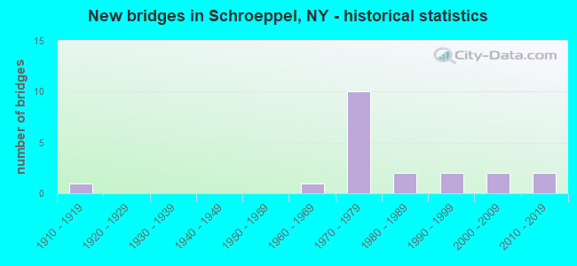
- New bridges - historical statistics
- 11910-1919
- 11960-1969
- 101970-1979
- 21980-1989
- 21990-1999
- 22000-2009
- 22010-2019

- Reconstructed bridges - Historical Statistics
- 11970-1979
- 01980-1989
- 11990-1999


- Bridge Condition - Deck
- 33.3%Good
- 33.3%Satisfactory
- 33.3%Fair

- Bridge Condition - Superstructure
- 7.7%Excellent
- 30.8%Good
- 15.4%Satisfactory
- 38.5%Fair
- 7.7%Poor

- Bridge Condition - Substructure
- 7.7%Excellent
- 30.8%Good
- 23.1%Satisfactory
- 38.5%Fair

- Bridge Condition - Channel
- 20.0%Very good
- 40.0%Satisfactory
- 40.0%Fair

- Bridge Condition - Culverts
- 50.0%Very good
- 50.0%Fair
Find on map >> Show street view
Structure Number: 10438, Location: 2.1 MI S JCT SH 264 & SH (Lat: 43.295353, Lng: -76.296717), Route carried "on" structure: State highway 264, Year Built: 1996, Status: Open, Structure Length: 1.49m (4.89ft), Average Daily Traffic: 2,888 (year 2020), Truck Traffic: 10%, Average Future Daily Traffic: 4,037 (year 2040), Design Load: HS 25 or greater, Features Intersected: SIX MILE CREEK
Minimum Vertical Clearance: 30+ m (98+ ft), Kilometerpoint: 7.530, Lanes on structure: 2, Base Highway Network: Yes, Owner: State Highway Agency, Approaching Roadway Width: 11.0m (36.1ft), Material/Design: Prestressed concrete, Design/Construction: Box Beam or Girders - Multiple, Number Of Spans In Main Unit: 1, Length of Maximum Span: 14.3m (46.9ft), Curb-To-Curb Width: 10.8m (35.4ft), Out-to-Out Width: 11.4m (37.4ft)
Condition: Deck: Satisfactory, Superstructure: Good, Substructure: Good, Channel: Satisfactory, Operating Rating: 68.9 metric tons, Method Used To Determine Operating Rating: Load Factor (LF), Inventory Rating: 45.4 metric tons, Method Used To Determine Inventory Rating: Load Factor (LF), Structural Evaluation: Better than present minimum criteria, Deck Geometry: Somewhat better than minimum adequacy, Waterway Adequacy: Meets minimum limits, Approach Roadway Alignment: Equal to present desirable criteria, Length Of Structure Improvement: 1.49m (4.89ft), Designated Inspection Frequency: Every 24 months, Inspection Date: July 2020, Bridge Improvement Cost: $471,000, Roadway Improvement Cost: $276,000, Total Project Cost: $747,000 ( Estimate for 2021), Wearing Surface/Protective System: Wearing Surface: Monolithic Concrete
Find on map >> Show street view
Structure Number: 10647, Location: 2.4 MI SE JCT RTS 481+264 (Lat: 43.227225, Lng: -76.275094), Route carried "on" structure: Other road , Year Built: 1970, Year Reconstructed: 1981, Status: Open, Structure Length: 4.97m (16.31ft), Average Daily Traffic: 2,708 (year 2017), Truck Traffic: 4%, Average Future Daily Traffic: 3,786 (year 2040), Design Load: H 20, Features Intersected: 481 481 34021012 - south, Facility Carried by Structure: CO RD 57A
Minimum Vertical Clearance: 30+ m (98+ ft), Kilometerpoint: 1.400, Lanes on structure: 3, Lanes under structure: 8, Owner: State Highway Agency, Approaching Roadway Width: 17.1m (56.1ft), Material/Design: Steel, Design/Construction: Stringer/Multi-beam, Number Of Spans In Main Unit: 1, Length of Maximum Span: 48.7m (159.8ft), Curb-To-Curb Width: 16.8m (55.1ft), Out-to-Out Width: 17.7m (58.1ft)
Condition: Deck: Good, Superstructure: Good, Substructure: Satisfactory, Operating Rating: 78.9 metric tons, Method Used To Determine Operating Rating: Load Factor (LF), Inventory Rating: 47.2 metric tons, Method Used To Determine Inventory Rating: Load Factor (LF), Structural Evaluation: Equal to present minimum criteria, Deck Geometry: Superior to present desirable criteria, Underclear: Somewhat better than minimum adequacy, Approach Roadway Alignment: Equal to present desirable criteria, Length Of Structure Improvement: 4.96m (16.27ft), Designated Inspection Frequency: Every 24 months, Inspection Date: May 2021, Bridge Improvement Cost: $2,212,000, Roadway Improvement Cost: $1,295,000, Total Project Cost: $3,508,000 ( Estimate for 2021), Deck Structure Type: Concrete Cast-file-Place, Wearing Surface/Protective System: Wearing Surface: Monolithic Concrete
Find on map >> Show street view
Structure Number: 1064711, Location: 1.5 MI SE JCT SH481&SH264 (Lat: 43.236892, Lng: -76.283478), Route carried "on" structure: State highway 481, Year Built: 1970, Status: Open, Structure Length: 3.14m (10.30ft), Average Daily Traffic: 8,300 (year 2010), Truck Traffic: 7%, Average Future Daily Traffic: 12,122 (year 2040), Design Load: H 20, Features Intersected: PHOENIX RD - CR12
Minimum Vertical Clearance: 30+ m (98+ ft), Kilometerpoint: 3.170, Lanes on structure: 2, Lanes under structure: 2, Base Highway Network: Yes, Owner: State Highway Agency, Approaching Roadway Width: 12.8m (42.0ft), Skew: 2 degrees, Material/Design: Steel, Design/Construction: Stringer/Multi-beam, Number Of Spans In Main Unit: 1, Length of Maximum Span: 30.1m (98.8ft), Curb-To-Curb Width: 11.9m (39.0ft), Out-to-Out Width: 12.8m (42.0ft)
Condition: Deck: Fair, Superstructure: Fair, Substructure: Fair, Operating Rating: 79.8 metric tons, Method Used To Determine Operating Rating: Load Factor (LF), Inventory Rating: 48.1 metric tons, Method Used To Determine Inventory Rating: Load Factor (LF), Structural Evaluation: Somewhat better than minimum adequacy, Deck Geometry: Better than present minimum criteria, Underclear: Meets minimum limits, Approach Roadway Alignment: Equal to present desirable criteria, Length Of Structure Improvement: 3.13m (10.27ft), Designated Inspection Frequency: Every 24 months, Inspection Date: May 2021, Bridge Improvement Cost: $1,132,000, Roadway Improvement Cost: $663,000, Total Project Cost: $1,795,000 ( Estimate for 2021), Deck Structure Type: Concrete Cast-file-Place, Wearing Surface/Protective System: Wearing Surface: Epoxy Overlay
Find on map >> Show street view
Structure Number: 1064712, Location: 1.5 MI SE JCT SH481&SH264 (Lat: 43.236947, Lng: -76.283197), Route carried "on" structure: State highway 481, Year Built: 1970, Status: Open, Structure Length: 3.14m (10.30ft), Average Daily Traffic: 8,300 (year 2010), Truck Traffic: 7%, Average Future Daily Traffic: 12,122 (year 2040), Design Load: H 20, Features Intersected: PHOENIX RD - CR12
Minimum Vertical Clearance: 30+ m (98+ ft), Kilometerpoint: 3.170, Lanes on structure: 2, Lanes under structure: 2, Base Highway Network: Yes, Owner: State Highway Agency, Approaching Roadway Width: 12.8m (42.0ft), Skew: 2 degrees, Material/Design: Steel, Design/Construction: Stringer/Multi-beam, Number Of Spans In Main Unit: 1, Length of Maximum Span: 30.1m (98.8ft), Curb-To-Curb Width: 11.9m (39.0ft), Out-to-Out Width: 12.8m (42.0ft)
Condition: Deck: Satisfactory, Superstructure: Fair, Substructure: Fair, Operating Rating: 84.4 metric tons, Method Used To Determine Operating Rating: Load Factor (LF), Inventory Rating: 49.9 metric tons, Method Used To Determine Inventory Rating: Load Factor (LF), Structural Evaluation: Somewhat better than minimum adequacy, Deck Geometry: Better than present minimum criteria, Underclear: Meets minimum limits, Approach Roadway Alignment: Equal to present desirable criteria, Length Of Structure Improvement: 3.13m (10.27ft), Designated Inspection Frequency: Every 24 months, Inspection Date: May 2021, Bridge Improvement Cost: $1,163,000, Roadway Improvement Cost: $681,000, Total Project Cost: $1,844,000 ( Estimate for 2021), Deck Structure Type: Concrete Cast-file-Place, Wearing Surface/Protective System: Wearing Surface: Epoxy Overlay
Find on map >> Show street view
Structure Number: 106472, Location: JCT OF RTS 481 + 264 (Lat: 43.251192, Lng: -76.305783), Route carried "on" structure: State highway 264, Year Built: 1970, Status: Open, Structure Length: 6.52m (21.39ft), Average Daily Traffic: 4,363 (year 2020), Truck Traffic: 11%, Average Future Daily Traffic: 4,390 (year 2040), Design Load: H 20, Features Intersected: 481 481 34021035 NB, RTE
Minimum Vertical Clearance: 30+ m (98+ ft), Kilometerpoint: 2.317, Lanes on structure: 4, Lanes under structure: 4, Base Highway Network: Yes, Owner: State Highway Agency, Approaching Roadway Width: 18.3m (60.0ft), Skew: 23 degrees, Material/Design: Steel, Design/Construction: Stringer/Multi-beam, Number Of Spans In Main Unit: 2, Length of Maximum Span: 31.6m (103.7ft), Curb-To-Curb Width: 18.0m (59.1ft), Out-to-Out Width: 18.9m (62.0ft)
Condition: Deck: Satisfactory, Superstructure: Satisfactory, Substructure: Fair, Operating Rating: 47.0 metric tons, Method Used To Determine Operating Rating: Load and Resistance Factor Rating (LRFR) rating reported by rating factor(RF) method using HL-93 loadings, Inventory Rating: 36.3 metric tons, Method Used To Determine Inventory Rating: Load and Resistance Factor Rating (LRFR) rating reported by rating factor(RF) method using HL-93 loadings, Structural Evaluation: Somewhat better than minimum adequacy, Deck Geometry: Somewhat better than minimum adequacy, Underclear: Somewhat better than minimum adequacy, Approach Roadway Alignment: Equal to present desirable criteria, Length Of Structure Improvement: 6.52m (21.39ft), Designated Inspection Frequency: Every 24 months, Inspection Date: May 2021, Bridge Improvement Cost: $2,975,000, Roadway Improvement Cost: $1,742,000, Total Project Cost: $4,716,000 ( Estimate for 2021), Deck Structure Type: Concrete Cast-file-Place, Wearing Surface/Protective System: Wearing Surface: Monolithic Concrete
Find on map >> Show street view
Structure Number: 106473, Location: 2.2 MI NW JCT RTS 481+264 (Lat: 43.278558, Lng: -76.329192), Route carried "on" structure: Other road , Year Built: 1970, Status: Open, Structure Length: 7.28m (23.88ft), Average Daily Traffic: 1,246 (year 2020), Truck Traffic: 12%, Average Future Daily Traffic: 1,744 (year 2040), Design Load: H 20, Features Intersected: 481 481 34021058 Northbo, Facility Carried by Structure: BANKRUPT ROAD
Minimum Vertical Clearance: 32.69m (107.25ft), Kilometerpoint: 2.253, Lanes on structure: 2, Lanes under structure: 4, Owner: State Highway Agency, Approaching Roadway Width: 6.7m (22.0ft), Skew: 3 degrees, Material/Design: Steel, Design/Construction: Stringer/Multi-beam, Number Of Spans In Main Unit: 2, Length of Maximum Span: 36.2m (118.8ft), Curb-To-Curb Width: 10.7m (35.1ft), Out-to-Out Width: 11.6m (38.1ft)
Condition: Deck: Good, Superstructure: Good, Substructure: Satisfactory, Operating Rating: 83.5 metric tons, Method Used To Determine Operating Rating: Load Factor (LF), Inventory Rating: 49.9 metric tons, Method Used To Determine Inventory Rating: Load Factor (LF), Structural Evaluation: Equal to present minimum criteria, Deck Geometry: Equal to present minimum criteria, Underclear: Somewhat better than minimum adequacy, Approach Roadway Alignment: Equal to present desirable criteria, Length Of Structure Improvement: 7.28m (23.88ft), Designated Inspection Frequency: Every 24 months, Inspection Date: May 2021, Bridge Improvement Cost: $2,019,000, Roadway Improvement Cost: $1,182,000, Total Project Cost: $3,201,000 ( Estimate for 2021), Deck Structure Type: Concrete Cast-file-Place, Wearing Surface/Protective System: Wearing Surface: Bituminous
Find on map >> Show street view
Structure Number: 107938, Location: 1.4 mi NE jct Rt 481 (Lat: 43.270486, Lng: -76.298250), Route carried "on" structure: State highway 264, Year Built: 2012, Status: Open, Structure Length: 1.04m (3.41ft), Average Daily Traffic: 2,888 (year 2020), Truck Traffic: 10%, Average Future Daily Traffic: 4,037 (year 2040), Design Load: HL 93, Features Intersected: Bell Creek
Minimum Vertical Clearance: 32.69m (107.25ft), Kilometerpoint: 4.586, Lanes on structure: 2, Base Highway Network: Yes, Owner: State Highway Agency, Approaching Roadway Width: 9.8m (32.2ft), Skew: 1 degrees, Material/Design: Concrete, Design/Construction: Frame, Number Of Spans In Main Unit: 1, Length of Maximum Span: 10.0m (32.8ft), Curb-To-Curb Width: 9.8m (32.2ft), Out-to-Out Width: 10.0m (32.8ft)
Condition: Superstructure: Excellent, Substructure: Excellent, Channel: Fair, Operating Rating: 79.7 metric tons, Method Used To Determine Operating Rating: Field evaluation and documented engineering judgment, Inventory Rating: 40.8 metric tons, Method Used To Determine Inventory Rating: Field evaluation and documented engineering judgment, Structural Evaluation: Superior to present desirable criteria, Deck Geometry: Meets minimum limits, Waterway Adequacy: Equal to present minimum criteria, Approach Roadway Alignment: Equal to present desirable criteria, Length Of Structure Improvement: 1.03m (3.38ft), Designated Inspection Frequency: Every 24 months, Inspection Date: September 2020, Bridge Improvement Cost: $507,000, Roadway Improvement Cost: $297,000, Total Project Cost: $804,000 ( Estimate for 2021), Wearing Surface/Protective System: Wearing Surface: Bituminous
Find on map >> Show street view
Structure Number: 22093, Location: 2.8 MI NW OF PENNELLVILLE (Lat: 43.303906, Lng: -76.308478), Route carried "on" structure: Other road , Year Built: 1964, Status: Open, Structure Length: 0.82m (2.69ft), Average Daily Traffic: 101 (year 2020), Truck Traffic: 8%, Average Future Daily Traffic: 141 (year 2040), Design Load: HS 20, Features Intersected: SIXMILE CREEK, Facility Carried by Structure: PRIOR ROAD
Minimum Vertical Clearance: 30+ m (98+ ft), Kilometerpoint: 0.499, Lanes on structure: 2, Owner: Town or Township Highway Agency, Approaching Roadway Width: 5.8m (19.0ft), Material/Design: Steel, Design/Construction: Stringer/Multi-beam, Number Of Spans In Main Unit: 1, Length of Maximum Span: 7.6m (24.9ft), Curb-To-Curb Width: 8.1m (26.6ft), Out-to-Out Width: 8.3m (27.2ft)
Condition: Deck: Fair, Superstructure: Fair, Substructure: Fair, Channel: Satisfactory, Operating Rating: 44.5 metric tons, Method Used To Determine Operating Rating: Load Factor (LF), Inventory Rating: 26.3 metric tons, Method Used To Determine Inventory Rating: Load Factor (LF), Structural Evaluation: Somewhat better than minimum adequacy, Deck Geometry: Somewhat better than minimum adequacy, Waterway Adequacy: Meets minimum limits, Approach Roadway Alignment: Equal to present desirable criteria, Length Of Structure Improvement: 0.82m (2.69ft), Designated Inspection Frequency: Every 24 months, Inspection Date: June 2020, Bridge Improvement Cost: $215,000, Roadway Improvement Cost: $126,000, Total Project Cost: $341,000 ( Estimate for 2021), Deck Structure Type: Concrete Cast-file-Place, Wearing Surface/Protective System: Wearing Surface: Bituminous
Find on map >> Show street view
Structure Number: 220931, Location: 1.6 MI SE OF PENNELLVILLE (Lat: 43.258472, Lng: -76.258583), Route carried "on" structure: Other road , Year Built: 1987, Status: Open, Structure Length: 1.13m (3.71ft), Average Daily Traffic: 727 (year 2016), Truck Traffic: 3%, Average Future Daily Traffic: 1,018 (year 2036), Features Intersected: FISH CREEK, Facility Carried by Structure: SUTTON ROAD
Minimum Vertical Clearance: 30+ m (98+ ft), Kilometerpoint: 0.611, Lanes on structure: 2, Owner: Town or Township Highway Agency, Approaching Roadway Width: 8.2m (26.9ft), Skew: 2 degrees, Material/Design: Steel, Design/Construction: Stringer/Multi-beam, Number Of Spans In Main Unit: 1, Length of Maximum Span: 11.0m (36.1ft), Curb-To-Curb Width: 8.2m (26.9ft), Out-to-Out Width: 8.8m (28.9ft)
Condition: Deck: Good, Superstructure: Good, Substructure: Good, Channel: Satisfactory, Inventory Rating: 76.2 metric tons, Method Used To Determine Inventory Rating: Allowable Stress (AS), Structural Evaluation: Better than present minimum criteria, Deck Geometry: Somewhat better than minimum adequacy, Waterway Adequacy: Meets minimum limits, Approach Roadway Alignment: Equal to present desirable criteria, Length Of Structure Improvement: 1.12m (3.67ft), Designated Inspection Frequency: Every 24 months, Inspection Date: October 2021, Bridge Improvement Cost: $306,000, Roadway Improvement Cost: $179,000, Total Project Cost: $486,000 ( Estimate for 2021), Deck Structure Type: Corrugated Steel, Wearing Surface/Protective System: Wearing Surface: Bituminous
Find on map >> Show street view
Structure Number: 331347, Location: 2.8 MI NE OF PHOENIX (Lat: 43.268983, Lng: -76.296814), Route carried "on" structure: County highway , Year Built: 1996, Status: Open, Structure Length: 0.98m (3.22ft), Average Daily Traffic: 643 (year 2016), Truck Traffic: 4%, Average Future Daily Traffic: 900 (year 2036), Features Intersected: BELLS CREEK, Facility Carried by Structure: CR54-PENNELVLE RD
Minimum Vertical Clearance: 30+ m (98+ ft), Kilometerpoint: 0.386, Lanes on structure: 2, Owner: County Highway Agency, Approaching Roadway Width: 8.5m (27.9ft), Material/Design: Steel, Design/Construction: Culvert, Number Of Spans In Main Unit: 2, Length of Maximum Span: 4.2m (13.8ft)
Condition: Channel: Satisfactory, Culverts: Fair, Operating Rating: 74.4 metric tons, Method Used To Determine Operating Rating: Field evaluation and documented engineering judgment, Inventory Rating: 24.5 metric tons, Method Used To Determine Inventory Rating: Field evaluation and documented engineering judgment, Structural Evaluation: Somewhat better than minimum adequacy, Waterway Adequacy: Equal to present desirable criteria, Approach Roadway Alignment: Better than present minimum criteria, Length Of Structure Improvement: 0.97m (3.18ft), Designated Inspection Frequency: Every 24 months, Underwater Inspection Frequency: Every 60 months, Inspection Date: December 2020, Underwater Inspection Date: June 2019, Bridge Improvement Cost: $193,000, Roadway Improvement Cost: $113,000, Total Project Cost: $306,000 ( Estimate for 2021)
Find on map >> Show street view
Structure Number: 331348, Location: 2.8 MI NE OF PHOENIX (Lat: 43.270439, Lng: -76.291708), Route carried "on" structure: County highway , Year Built: 1987, Status: Open, Structure Length: 1.01m (3.31ft), Average Daily Traffic: 643 (year 2016), Truck Traffic: 4%, Average Future Daily Traffic: 900 (year 2036), Features Intersected: SIXMILE CREEK, Facility Carried by Structure: PENNELLVILLE RD
Minimum Vertical Clearance: 30+ m (98+ ft), Kilometerpoint: 0.821, Lanes on structure: 2, Owner: County Highway Agency, Approaching Roadway Width: 7.9m (25.9ft), Material/Design: Steel, Design/Construction: Stringer/Multi-beam, Number Of Spans In Main Unit: 1, Length of Maximum Span: 9.7m (31.8ft), Curb-To-Curb Width: 8.6m (28.2ft), Out-to-Out Width: 8.9m (29.2ft)
Condition: Deck: Satisfactory, Superstructure: Satisfactory, Substructure: Satisfactory, Channel: Fair, Inventory Rating: 98.0 metric tons, Method Used To Determine Inventory Rating: Allowable Stress (AS), Structural Evaluation: Equal to present minimum criteria, Deck Geometry: Somewhat better than minimum adequacy, Waterway Adequacy: Meets minimum limits, Approach Roadway Alignment: Equal to present desirable criteria, Length Of Structure Improvement: 1.00m (3.28ft), Designated Inspection Frequency: Every 24 months, Inspection Date: October 2021, Bridge Improvement Cost: $163,000, Roadway Improvement Cost: $95,000, Total Project Cost: $258,000 ( Estimate for 2021), Deck Structure Type: Other, Wearing Surface/Protective System: Wearing Surface: Bituminous
Find on map >> Show street view
Structure Number: 331352, Location: 1.5 MI NE OF PHOENIX (Lat: 43.240381, Lng: -76.274742), Route carried "on" structure: County highway , Year Built: 2005, Status: Open, Structure Length: 1.31m (4.30ft), Average Daily Traffic: 2,540 (year 2020), Truck Traffic: 8%, Average Future Daily Traffic: 3,551 (year 2040), Features Intersected: SIXMILE CREEK, Facility Carried by Structure: CR12 PHOENIX ROAD
Minimum Vertical Clearance: 30+ m (98+ ft), Kilometerpoint: 2.526, Lanes on structure: 2, Owner: County Highway Agency, Approaching Roadway Width: 6.7m (22.0ft), Material/Design: Steel, Design/Construction: Stringer/Multi-beam, Number Of Spans In Main Unit: 1, Length of Maximum Span: 12.8m (42.0ft), Curb-To-Curb Width: 9.0m (29.5ft), Out-to-Out Width: 9.2m (30.2ft)
Condition: Deck: Fair, Superstructure: Fair, Substructure: Good, Channel: Very good, Operating Rating: 59.0 metric tons, Method Used To Determine Operating Rating: Load Factor (LF), Inventory Rating: 35.4 metric tons, Method Used To Determine Inventory Rating: Load Factor (LF), Structural Evaluation: Somewhat better than minimum adequacy, Deck Geometry: Meets minimum limits, Waterway Adequacy: Equal to present minimum criteria, Approach Roadway Alignment: Equal to present minimum criteria, Length Of Structure Improvement: 1.31m (4.30ft), Designated Inspection Frequency: Every 24 months, Underwater Inspection Frequency: Every 60 months, Inspection Date: October 2020, Underwater Inspection Date: July 2017, Bridge Improvement Cost: $319,000, Roadway Improvement Cost: $187,000, Total Project Cost: $505,000 ( Estimate for 2021), Deck Structure Type: Corrugated Steel, Wearing Surface/Protective System: Wearing Surface: Bituminous
Find on map >> Show street view
Structure Number: 331353, Location: 1.9 MI NE OF PHOENIX (Lat: 43.239572, Lng: -76.266158), Route carried "on" structure: County highway , Year Built: 2005, Status: Open, Structure Length: 1.04m (3.41ft), Average Daily Traffic: 1,792 (year 2020), Truck Traffic: 7%, Average Future Daily Traffic: 2,505 (year 2040), Features Intersected: FISH CREEK, Facility Carried by Structure: PHOENIX ROAD
Minimum Vertical Clearance: 30+ m (98+ ft), Kilometerpoint: 3.282, Lanes on structure: 2, Owner: County Highway Agency, Approaching Roadway Width: 7.9m (25.9ft), Material/Design: Steel, Design/Construction: Stringer/Multi-beam, Number Of Spans In Main Unit: 1, Length of Maximum Span: 9.8m (32.2ft), Curb-To-Curb Width: 8.8m (28.9ft), Out-to-Out Width: 9.2m (30.2ft)
Condition: Deck: Fair, Superstructure: Poor, Substructure: Fair, Channel: Fair, Operating Rating: 50.8 metric tons, Method Used To Determine Operating Rating: Load Factor (LF), Inventory Rating: 29.9 metric tons, Method Used To Determine Inventory Rating: Load Factor (LF), Structural Evaluation: Meets minimum limits, Deck Geometry: Somewhat better than minimum adequacy, Waterway Adequacy: Equal to present minimum criteria, Approach Roadway Alignment: Equal to present desirable criteria, Length Of Structure Improvement: 1.03m (3.38ft), Designated Inspection Frequency: Every 24 months, Inspection Date: August 2021, Bridge Improvement Cost: $254,000, Roadway Improvement Cost: $149,000, Total Project Cost: $402,000 ( Estimate for 2021), Deck Structure Type: Corrugated Steel, Wearing Surface/Protective System: Wearing Surface: Bituminous
Find on map >> Show street view
Structure Number: 336585, Location: 2 MI NW OF PENNELLVILLE (Lat: 43.296617, Lng: -76.297008), Route carried "on" structure: Other road , Year Built: 2014, Status: Open, Structure Length: 0.79m (2.59ft), Average Daily Traffic: 624 (year 2016), Truck Traffic: 7%, Average Future Daily Traffic: 874 (year 2036), Features Intersected: SIXMILE CREEK, Facility Carried by Structure: BIDDLECUM ROAD
Minimum Vertical Clearance: 30+ m (98+ ft), Kilometerpoint: 3.057, Lanes on structure: 2, Owner: Town or Township Highway Agency, Approaching Roadway Width: 7.3m (24.0ft), Material/Design: Steel, Design/Construction: Culvert, Number Of Spans In Main Unit: 2, Length of Maximum Span: 3.4m (11.2ft)
Condition: Channel: Fair, Culverts: Very good, Operating Rating: 74.9 metric tons, Method Used To Determine Operating Rating: Field evaluation and documented engineering judgment, Inventory Rating: 40.8 metric tons, Method Used To Determine Inventory Rating: Field evaluation and documented engineering judgment, Structural Evaluation: Equal to present desirable criteria, Waterway Adequacy: Somewhat better than minimum adequacy, Approach Roadway Alignment: Equal to present desirable criteria, Length Of Structure Improvement: 0.79m (2.59ft), Designated Inspection Frequency: Every 24 months, Underwater Inspection Frequency: Every 60 months, Inspection Date: September 2020, Underwater Inspection Date: June 2020, Bridge Improvement Cost: $134,000, Roadway Improvement Cost: $79,000, Total Project Cost: $213,000 ( Estimate for 2021)
Find on map >> Show street view
Structure Number: 443407, Location: AT HINMANSVILLE;OSWEGO R (Lat: 43.247886, Lng: -76.351761), Route carried "on" structure: County highway , Year Built: 1915, Year Reconstructed: 2003, Status: Open, Structure Length: 8.81m (28.90ft), Average Daily Traffic: 2,441 (year 2020), Truck Traffic: 7%, Average Future Daily Traffic: 2,510 (year 2040), Design Load: HS 20, Features Intersected: OSWEGO RIVER, Facility Carried by Structure: COUNTY ROAD 46
Minimum Vertical Clearance: 4.27m (14.01ft), Kilometerpoint: 0.981, Lanes on structure: 1, Owner: State Highway Agency, Approaching Roadway Width: 4.6m (15.1ft), Navigation Control: Yes ( Vertical Clearance: 6.1m (20.0ft), Horizontal Clearance: 28.9m (94.8ft)), Material/Design: Steel, Design/Construction: Truss - Thru, Number Of Spans In Main Unit: 2, Length of Maximum Span: 49.4m (162.1ft), Curb or Sidewalk Widths: Left: 1.2m (3.9ft), Right: 1.2m (3.9ft), Curb-To-Curb Width: 4.6m (15.1ft), Out-to-Out Width: 5.1m (16.7ft)
Condition: Deck: Good, Superstructure: Fair, Substructure: Good, Channel: Very good, Operating Rating: 73.5 metric tons, Method Used To Determine Operating Rating: Load Factor (LF), Inventory Rating: 43.5 metric tons, Method Used To Determine Inventory Rating: Load Factor (LF), Structural Evaluation: Somewhat better than minimum adequacy, Deck Geometry: High priority of replacement, Waterway Adequacy: Somewhat better than minimum adequacy, Approach Roadway Alignment: Somewhat better than minimum adequacy, Length Of Structure Improvement: 8.80m (28.87ft), Designated Inspection Frequency: Every 24 months, Critical Feature Inspection Frequency: Every 24 months, Underwater Inspection Frequency: Every 60 months, Inspection Date: September 2020, Critical Feature Inspection Date: September 2020, Underwater Inspection Date: June 2018, Bridge Improvement Cost: $3,999,000, Roadway Improvement Cost: $2,342,000, Total Project Cost: $6,341,000 ( Estimate for 2021), Deck Structure Type: Concrete Cast-file-Place, Wearing Surface/Protective System: Wearing Surface: Integral Concrete, Deck Protection: Epoxy Coated Reinforcing
Find on map >> Show street view
Structure Number: 10647, Location: 2.4 MI SE JCT RTS 481+264 (Lat: 43.227225, Lng: -76.275094), Route carried "under" structure: State highway 481, Year Built: 1970, Structure Length: 0. m, Average Daily Traffic: 17,138 (year 2002), Features Intersected: 481 481 34021012 - south, Facility Carried by Structure: CO RD 57A
Minimum Vertical Clearance: 4.57m (14.99ft), Kilometerpoint: 1.931, Lanes on structure: 3, Lanes under structure: 4, Material/Design: Steel, Design/Construction: Stringer/Multi-beam, Length of Maximum Span: 48.7m (159.8ft)
Find on map >> Show street view
Structure Number: 1064711, Location: 1.5 MI SE JCT SH481&SH264 (Lat: 43.236892, Lng: -76.283478), Route carried "under" structure: County highway , Year Built: 1970, Structure Length: 0. m, Average Daily Traffic: 437 (year 2020), Truck Traffic: 6%, Features Intersected: PHOENIX RD - CR12, Facility Carried by Structure: RTE 481
Minimum Vertical Clearance: 4.39m (14.40ft), Kilometerpoint: 0.370, Lanes on structure: 2, Lanes under structure: 2, Material/Design: Steel, Design/Construction: Stringer/Multi-beam, Length of Maximum Span: 30.1m (98.8ft)
Find on map >> Show street view
Structure Number: 1064712, Location: 1.5 MI SE JCT SH481&SH264 (Lat: 43.236947, Lng: -76.283197), Route carried "under" structure: County highway , Year Built: 1970, Structure Length: 0. m, Average Daily Traffic: 437 (year 2020), Truck Traffic: 6%, Features Intersected: PHOENIX RD - CR12, Facility Carried by Structure: RTE 481
Minimum Vertical Clearance: 4.72m (15.49ft), Kilometerpoint: 0.370, Lanes on structure: 2, Lanes under structure: 2, Material/Design: Steel, Design/Construction: Stringer/Multi-beam, Length of Maximum Span: 30.1m (98.8ft)
Find on map >> Show street view
Structure Number: 106472, Location: JCT OF RTS 481 + 264 (Lat: 43.251192, Lng: -76.305783), Route carried "under" structure: State highway 481, Year Built: 1970, Structure Length: 0. m, Average Daily Traffic: 14,887 (year 2002), Features Intersected: 481 481 34021035 NB, RTE, Facility Carried by Structure: RTE 264
Minimum Vertical Clearance: 4.57m (14.99ft), Kilometerpoint: 5.728, Lanes on structure: 4, Lanes under structure: 2, Material/Design: Steel, Design/Construction: Stringer/Multi-beam, Length of Maximum Span: 31.6m (103.7ft)
Find on map >> Show street view
Structure Number: 106473, Location: 2.2 MI NW JCT RTS 481+264 (Lat: 43.278558, Lng: -76.329192), Route carried "under" structure: State highway 481, Year Built: 1970, Structure Length: 0. m, Average Daily Traffic: 14,887 (year 2002), Features Intersected: 481 481 34021058 Northbo, Facility Carried by Structure: BANKRUPT ROAD
Minimum Vertical Clearance: 6.07m (19.91ft), Kilometerpoint: 9.397, Lanes on structure: 2, Lanes under structure: 2, Material/Design: Steel, Design/Construction: Stringer/Multi-beam, Length of Maximum Span: 36.2m (118.8ft)