Bridge Statistics for Russellville, Kentucky (KY)
Condition, Traffic, Stress, Structural Evaluation, Project Costs
- National Bridge Inventory (NBI) Statistics
- 39Number of bridges
- 308ft / 94.0mTotal length
- $1,735,000Total costs
- 121,511Total average daily traffic
- 7,505Total average daily truck traffic
- National Bridge Inventory (NBI) Registered Bridges for Russellville
- No street view available for this location
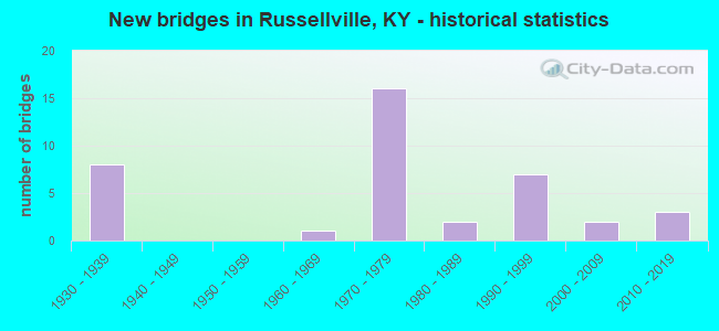
- New bridges - historical statistics
- 81930-1939
- 11960-1969
- 161970-1979
- 21980-1989
- 71990-1999
- 22000-2009
- 32010-2019


- Bridge Condition - Deck
- 15.4%Good
- 53.8%Satisfactory
- 30.8%Fair

- Bridge Condition - Superstructure
- 3.8%Very good
- 11.5%Good
- 65.4%Satisfactory
- 19.2%Fair

- Bridge Condition - Substructure
- 23.1%Good
- 50.0%Satisfactory
- 19.2%Fair
- 7.7%Poor

- Bridge Condition - Channel
- 10.8%Very good
- 59.5%Good
- 27.0%Satisfactory
- 2.7%Poor

- Bridge Condition - Culverts
- 25.0%Good
- 41.7%Satisfactory
- 33.3%Fair
Find on map >> Show street view
Structure Number: 71B00011N, Location: .4 MI S OF JCT KY 1588 (Lat: 36.876667, Lng: -86.857222), Route carried "on" structure: State highway 79, Year Built: 1972, Status: Open, Structure Length: 5.04m (16.54ft), Average Daily Traffic: 5,692 (year 2018), Truck Traffic: 25%, Average Future Daily Traffic: 4,724 (year 2038), Design Load: HS 20, Features Intersected: MUD RIVER
Minimum Vertical Clearance: 30+ m (98+ ft), Kilometerpoint: 4.480, Lanes on structure: 2, Base Highway Network: Yes, Owner: State Highway Agency, Approaching Roadway Width: 13.4m (44.0ft), Skew: 3 degrees, Material/Design: Prestressed concrete continuous, Design/Construction: Stringer/Multi-beam, Number Of Spans In Main Unit: 3, Length of Maximum Span: 16.2m (53.1ft), Curb or Sidewalk Widths: Left: 0.5m (1.6ft), Right: 0.5m (1.6ft), Curb-To-Curb Width: 13.4m (44.0ft), Out-to-Out Width: 14.3m (46.9ft)
Condition: Deck: Fair, Superstructure: Fair, Substructure: Satisfactory, Channel: Good, Operating Rating: 83.5 metric tons, Method Used To Determine Operating Rating: Load Factor (LF), Inventory Rating: 50.1 metric tons, Method Used To Determine Inventory Rating: Load Factor (LF), Structural Evaluation: Somewhat better than minimum adequacy, Deck Geometry: Equal to present minimum criteria, Waterway Adequacy: Equal to present desirable criteria, Approach Roadway Alignment: Equal to present desirable criteria, Designated Inspection Frequency: Every 24 months, Inspection Date: October 2021, Deck Structure Type: Concrete Cast-file-Place, Wearing Surface/Protective System: Wearing Surface: Monolithic Concrete
Find on map >> Show street view
Structure Number: 71B00016N, Location: .30 MI WEST OF JCT KY 96 (Lat: 36.763056, Lng: -86.911944), Route carried "on" structure: State highway 739, Year Built: 1970, Status: Posted for load, Structure Length: 0.98m (3.22ft), Average Daily Traffic: 66 (year 2018), Average Future Daily Traffic: 57 (year 2038), Design Load: H 15, Features Intersected: UNNAMED STREAM
Minimum Vertical Clearance: 30+ m (98+ ft), Kilometerpoint: 6.972, Lanes on structure: 2, Owner: State Highway Agency, Approaching Roadway Width: 5.6m (18.4ft), Material/Design: Concrete, Design/Construction: Channel Beam, Number Of Spans In Main Unit: 1, Length of Maximum Span: 9.1m (29.9ft), Curb-To-Curb Width: 6.1m (20.0ft), Out-to-Out Width: 6.4m (21.0ft)
Condition: Deck: Satisfactory, Superstructure: Fair, Substructure: Satisfactory, Channel: Good, Operating Rating: 40.7 metric tons, Method Used To Determine Operating Rating: Load Factor (LF), Inventory Rating: 24.4 metric tons, Method Used To Determine Inventory Rating: Load Factor (LF), Structural Evaluation: Somewhat better than minimum adequacy, Deck Geometry: Somewhat better than minimum adequacy, Waterway Adequacy: Equal to present minimum criteria, Approach Roadway Alignment: Equal to present desirable criteria, Bridge Posting: Required (Relationship of Operating Rating to Maximum Legal Load: > 39.9% below), Designated Inspection Frequency: Every 24 months, Inspection Date: October 2021, Deck Structure Type: Concrete Precast Panels, Wearing Surface/Protective System: Wearing Surface: Monolithic Concrete
Find on map >> Show street view
Structure Number: 71B00022N, Location: .30 MI NOR. OF JCT KY 739 (Lat: 36.770556, Lng: -86.904444), Route carried "on" structure: State highway 96, Year Built: 1934, Status: Open, Structure Length: 1.04m (3.41ft), Average Daily Traffic: 897 (year 2018), Average Future Daily Traffic: 789 (year 2038), Design Load: H 15, Features Intersected: UNNAMED STREAM
Minimum Vertical Clearance: 30+ m (98+ ft), Kilometerpoint: 17.886, Lanes on structure: 2, Owner: State Highway Agency, Approaching Roadway Width: 6.9m (22.6ft), Material/Design: Concrete, Design/Construction: Culvert, Number Of Spans In Main Unit: 3, Length of Maximum Span: 3.0m (9.8ft)
Condition: Channel: Satisfactory, Culverts: Satisfactory, Operating Rating: 54.4 metric tons, Method Used To Determine Operating Rating: Field evaluation and documented engineering judgment, Inventory Rating: 40.8 metric tons, Method Used To Determine Inventory Rating: Field evaluation and documented engineering judgment, Structural Evaluation: Equal to present minimum criteria, Waterway Adequacy: Equal to present minimum criteria, Approach Roadway Alignment: Equal to present desirable criteria, Designated Inspection Frequency: Every 24 months, Inspection Date: October 2021
Find on map >> Show street view
Structure Number: 71B00029N, Location: 1.3 MI N OF JCT US 68 (Lat: 36.849444, Lng: -86.928333), Route carried "on" structure: State highway 178, Year Built: 1934, Status: Posted for load, Structure Length: 0.98m (3.22ft), Average Daily Traffic: 2,323 (year 2018), Truck Traffic: 9%, Average Future Daily Traffic: 2,044 (year 2038), Design Load: H 15, Features Intersected: EDGER CREEK
Minimum Vertical Clearance: 30+ m (98+ ft), Kilometerpoint: 12.386, Lanes on structure: 2, Owner: State Highway Agency, Approaching Roadway Width: 6.4m (21.0ft), Skew: 3 degrees, Material/Design: Concrete, Design/Construction: Culvert, Number Of Spans In Main Unit: 3, Length of Maximum Span: 2.4m (7.9ft)
Condition: Channel: Good, Culverts: Fair, Operating Rating: 20.0 metric tons, Method Used To Determine Operating Rating: Field evaluation and documented engineering judgment, Inventory Rating: 20.0 metric tons, Method Used To Determine Inventory Rating: Field evaluation and documented engineering judgment, Structural Evaluation: Somewhat better than minimum adequacy, Waterway Adequacy: Equal to present minimum criteria, Approach Roadway Alignment: Equal to present desirable criteria, Bridge Posting: Required (Relationship of Operating Rating to Maximum Legal Load: > 39.9% below), Designated Inspection Frequency: Every 24 months, Inspection Date: October 2021
Find on map >> Show street view
Structure Number: 71B00045N, Location: 0.68 MI N OF JCT W/KY 79 (Lat: 36.850278, Lng: -86.890000), Route carried "on" structure: State highway 3519, Year Built: 1933, Status: Open, Structure Length: 0.76m (2.49ft), Average Daily Traffic: 11,752 (year 2018), Truck Traffic: 4%, Average Future Daily Traffic: 10,929 (year 2038), Design Load: H 15, Features Intersected: TOWN BRANCH
Minimum Vertical Clearance: 30+ m (98+ ft), Kilometerpoint: 0.568, Lanes on structure: 2, Owner: State Highway Agency, Approaching Roadway Width: 7.6m (24.9ft), Material/Design: Concrete, Design/Construction: Culvert, Number Of Spans In Main Unit: 2, Length of Maximum Span: 3.7m (12.1ft)
Condition: Channel: Good, Culverts: Good, Operating Rating: 54.4 metric tons, Method Used To Determine Operating Rating: Field evaluation and documented engineering judgment, Inventory Rating: 40.8 metric tons, Method Used To Determine Inventory Rating: Field evaluation and documented engineering judgment, Structural Evaluation: Better than present minimum criteria, Waterway Adequacy: Equal to present minimum criteria, Approach Roadway Alignment: Equal to present desirable criteria, Designated Inspection Frequency: Every 24 months, Inspection Date: October 2021
Find on map >> Show street view
Structure Number: 71B00047N, Location: .3 MI WEST OF JCT Ky 2146 (Lat: 36.845278, Lng: -86.895556), Route carried "on" structure: Business US 68, Year Built: 1936, Status: Open, Structure Length: 11.09m (36.38ft), Average Daily Traffic: 7,644 (year 2018), Truck Traffic: 9%, Average Future Daily Traffic: 7,108 (year 2038), Design Load: H 15, Features Intersected: RJC RAILROAD
Minimum Vertical Clearance: 30+ m (98+ ft), Kilometerpoint: 2.160, Lanes on structure: 2, Lanes under structure: 1, Owner: State Highway Agency, Approaching Roadway Width: 6.7m (22.0ft), Skew: 1 degrees, Material/Design: Concrete, Design/Construction: Tee Beam, Number Of Spans In Main Unit: 7, Length of Maximum Span: 15.2m (49.9ft), Curb or Sidewalk Widths: Left: 0.2m (0.7ft), Right: 1.5m (4.9ft), Curb-To-Curb Width: 7.3m (24.0ft), Out-to-Out Width: 9.1m (29.9ft)
Condition: Deck: Fair, Superstructure: Fair, Substructure: Poor, Operating Rating: 59.7 metric tons, Method Used To Determine Operating Rating: Load Factor (LF), Inventory Rating: 35.8 metric tons, Method Used To Determine Inventory Rating: Load Factor (LF), Structural Evaluation: Meets minimum limits, Deck Geometry: High priority of replacement, Underclear: Better than present minimum criteria, Approach Roadway Alignment: Better than present minimum criteria, Length Of Structure Improvement: 1.11m (3.64ft), Designated Inspection Frequency: Every 24 months, Inspection Date: November 2021, Bridge Improvement Cost: $1,360,000, Total Project Cost: $1,360,000, Deck Structure Type: Concrete Cast-file-Place, Wearing Surface/Protective System: Wearing Surface: Low Slump Concrete
Find on map >> Show street view
Structure Number: 71B00054N, Location: .39 MI EAST OF JCT US 431 (Lat: 36.762778, Lng: -86.859167), Route carried "on" structure: State highway 664, Year Built: 1978, Status: Open, Structure Length: 1.04m (3.41ft), Average Daily Traffic: 386 (year 2019), Average Future Daily Traffic: 335 (year 2039), Design Load: HS 20, Features Intersected: WHIPPOORWILL CRK
Minimum Vertical Clearance: 30+ m (98+ ft), Kilometerpoint: 0.634, Lanes on structure: 2, Owner: State Highway Agency, Approaching Roadway Width: 6.1m (20.0ft), Material/Design: Prestressed concrete, Design/Construction: Box Beam or Girders - Multiple, Number Of Spans In Main Unit: 1, Length of Maximum Span: 9.8m (32.2ft), Curb or Sidewalk Widths: Left: 0.2m (0.7ft), Right: 0.2m (0.7ft), Curb-To-Curb Width: 6.9m (22.6ft), Out-to-Out Width: 7.3m (24.0ft)
Condition: Deck: Satisfactory, Superstructure: Satisfactory, Substructure: Satisfactory, Channel: Satisfactory, Operating Rating: 92.3 metric tons, Method Used To Determine Operating Rating: Load Factor (LF), Inventory Rating: 55.3 metric tons, Method Used To Determine Inventory Rating: Load Factor (LF), Structural Evaluation: Equal to present minimum criteria, Deck Geometry: Meets minimum limits, Waterway Adequacy: Equal to present minimum criteria, Approach Roadway Alignment: Equal to present desirable criteria, Designated Inspection Frequency: Every 24 months, Inspection Date: November 2021, Deck Structure Type: Concrete Precast Panels, Wearing Surface/Protective System: Wearing Surface: Monolithic Concrete
Find on map >> Show street view
Structure Number: 71B00055N, Location: .10 MI EAST OF JCT US 431 (Lat: 36.848889, Lng: -86.887778), Route carried "on" structure: State highway 79, Year Built: 1976, Status: Open, Structure Length: 1.30m (4.27ft), Average Daily Traffic: 1,867 (year 2019), Truck Traffic: 7%, Average Future Daily Traffic: 1,736 (year 2039), Design Load: HS 20, Features Intersected: E FK TOWN BRANCH
Minimum Vertical Clearance: 30+ m (98+ ft), Kilometerpoint: 0.103, Lanes on structure: 2, Owner: State Highway Agency, Approaching Roadway Width: 8.2m (26.9ft), Skew: 3 degrees, Material/Design: Prestressed concrete, Design/Construction: Box Beam or Girders - Multiple, Number Of Spans In Main Unit: 1, Length of Maximum Span: 12.2m (40.0ft), Curb-To-Curb Width: 8.8m (28.9ft), Out-to-Out Width: 9.3m (30.5ft)
Condition: Deck: Fair, Superstructure: Satisfactory, Substructure: Fair, Channel: Good, Operating Rating: 85.7 metric tons, Method Used To Determine Operating Rating: Load Factor (LF), Inventory Rating: 51.4 metric tons, Method Used To Determine Inventory Rating: Load Factor (LF), Structural Evaluation: Somewhat better than minimum adequacy, Deck Geometry: Somewhat better than minimum adequacy, Waterway Adequacy: Equal to present minimum criteria, Approach Roadway Alignment: Equal to present desirable criteria, Designated Inspection Frequency: Every 24 months, Inspection Date: November 2021, Deck Structure Type: Concrete Precast Panels, Wearing Surface/Protective System: Wearing Surface: Monolithic Concrete
Find on map >> Show street view
Structure Number: 71B00056N, Location: .3 MI EAST OF JCT US 431 (Lat: 36.846944, Lng: -86.881667), Route carried "on" structure: Business US 68, Year Built: 1976, Status: Open, Structure Length: 1.28m (4.20ft), Average Daily Traffic: 6,188 (year 2018), Truck Traffic: 8%, Average Future Daily Traffic: 5,754 (year 2038), Design Load: HS 20, Features Intersected: E FORK TOWN BRANCH
Minimum Vertical Clearance: 30+ m (98+ ft), Kilometerpoint: 3.528, Lanes on structure: 2, Owner: State Highway Agency, Approaching Roadway Width: 8.7m (28.5ft), Skew: 3 degrees, Material/Design: Prestressed concrete, Design/Construction: Box Beam or Girders - Multiple, Number Of Spans In Main Unit: 1, Length of Maximum Span: 12.2m (40.0ft), Curb-To-Curb Width: 8.7m (28.5ft), Out-to-Out Width: 9.1m (29.9ft)
Condition: Deck: Fair, Superstructure: Satisfactory, Substructure: Satisfactory, Channel: Good, Operating Rating: 85.7 metric tons, Method Used To Determine Operating Rating: Load Factor (LF), Inventory Rating: 51.4 metric tons, Method Used To Determine Inventory Rating: Load Factor (LF), Structural Evaluation: Equal to present minimum criteria, Deck Geometry: High priority of replacement, Waterway Adequacy: Equal to present minimum criteria, Approach Roadway Alignment: Equal to present desirable criteria, Length Of Structure Improvement: 0.13m (0.43ft), Designated Inspection Frequency: Every 24 months, Inspection Date: November 2021, Bridge Improvement Cost: $155,000, Total Project Cost: $154,000, Deck Structure Type: Concrete Cast-file-Place, Wearing Surface/Protective System: Wearing Surface: Monolithic Concrete
Find on map >> Show street view
Structure Number: 71B00073N, Location: .15 MI W OF JCT US68&K100 (Lat: 36.843056, Lng: -86.874722), Route carried "on" structure: State highway 3240, Year Built: 1935, Status: Open, Structure Length: 0.91m (2.99ft), Average Daily Traffic: 4,978 (year 2020), Truck Traffic: 9%, Average Future Daily Traffic: 4,629 (year 2040), Features Intersected: E FK TOWN BRANCH
Minimum Vertical Clearance: 30+ m (98+ ft), Kilometerpoint: 3.289, Lanes on structure: 2, Owner: State Highway Agency, Approaching Roadway Width: 10.4m (34.1ft), Material/Design: Concrete, Design/Construction: Culvert, Number Of Spans In Main Unit: 2, Length of Maximum Span: 3.4m (11.2ft)
Condition: Channel: Good, Culverts: Satisfactory, Operating Rating: 54.4 metric tons, Method Used To Determine Operating Rating: Field evaluation and documented engineering judgment, Inventory Rating: 39.9 metric tons, Method Used To Determine Inventory Rating: Field evaluation and documented engineering judgment, Structural Evaluation: Equal to present minimum criteria, Waterway Adequacy: Better than present minimum criteria, Approach Roadway Alignment: Equal to present desirable criteria, Designated Inspection Frequency: Every 24 months, Inspection Date: November 2021
Find on map >> Show street view
Structure Number: 71B00075N, Location: 0.1 MI. W.OF JCT. KY 2146 (Lat: 36.844444, Lng: -86.893333), Route carried "on" structure: Business US 68, Year Built: 1936, Status: Open, Structure Length: 0.70m (2.30ft), Average Daily Traffic: 7,644 (year 2018), Truck Traffic: 9%, Average Future Daily Traffic: 7,108 (year 2038), Features Intersected: TOWN BRANCH
Minimum Vertical Clearance: 30+ m (98+ ft), Kilometerpoint: 2.380, Lanes on structure: 2, Owner: State Highway Agency, Approaching Roadway Width: 9.1m (29.9ft), Skew: 4 degrees, Material/Design: Concrete, Design/Construction: Culvert, Number Of Spans In Main Unit: 2, Length of Maximum Span: 2.4m (7.9ft)
Condition: Channel: Good, Culverts: Satisfactory, Operating Rating: 54.4 metric tons, Method Used To Determine Operating Rating: Field evaluation and documented engineering judgment, Inventory Rating: 39.9 metric tons, Method Used To Determine Inventory Rating: Field evaluation and documented engineering judgment, Structural Evaluation: Equal to present minimum criteria, Waterway Adequacy: Equal to present minimum criteria, Approach Roadway Alignment: Equal to present desirable criteria, Designated Inspection Frequency: Every 24 months, Inspection Date: November 2021
Find on map >> Show street view
Structure Number: 71B00076N, Location: .05 MI.N. OF JCT. US 68 (Lat: 36.844722, Lng: -86.892778), Route carried "on" structure: State highway 2146, Year Built: 1930, Status: Open, Structure Length: 0.67m (2.20ft), Average Daily Traffic: 5,690 (year 2018), Average Future Daily Traffic: 5,291 (year 2038), Features Intersected: TOWN BRANCH
Minimum Vertical Clearance: 30+ m (98+ ft), Kilometerpoint: 4.286, Lanes on structure: 2, Owner: State Highway Agency, Approaching Roadway Width: 8.5m (27.9ft), Material/Design: Concrete, Design/Construction: Culvert, Number Of Spans In Main Unit: 2, Length of Maximum Span: 3.0m (9.8ft)
Condition: Channel: Satisfactory, Culverts: Fair, Operating Rating: 54.4 metric tons, Method Used To Determine Operating Rating: Field evaluation and documented engineering judgment, Inventory Rating: 39.9 metric tons, Method Used To Determine Inventory Rating: Field evaluation and documented engineering judgment, Structural Evaluation: Somewhat better than minimum adequacy, Waterway Adequacy: Equal to present minimum criteria, Approach Roadway Alignment: Equal to present desirable criteria, Designated Inspection Frequency: Every 24 months, Inspection Date: November 2021
Find on map >> Show street view
Structure Number: 71B00078N, Location: 100 YDS N OF JCT US 431 (Lat: 36.831667, Lng: -86.906389), Route carried "on" structure: State highway 3233, Year Built: 1970, Status: Open, Structure Length: 0.64m (2.10ft), Average Daily Traffic: 2,335 (year 2019), Average Future Daily Traffic: 2,171 (year 2039), Features Intersected: TOWN BRANCH
Minimum Vertical Clearance: 30+ m (98+ ft), Kilometerpoint: 0.095, Lanes on structure: 2, Owner: State Highway Agency, Approaching Roadway Width: 7.2m (23.6ft), Skew: 2 degrees, Material/Design: Steel, Design/Construction: Culvert, Number Of Spans In Main Unit: 2, Length of Maximum Span: 2.6m (8.5ft)
Condition: Channel: Satisfactory, Culverts: Fair, Operating Rating: 70.0 metric tons, Method Used To Determine Operating Rating: Load and Resistance Factor Rating (LRFR) rating reported by rating factor(RF) method using HL-93 loadings, Inventory Rating: 66.4 metric tons, Method Used To Determine Inventory Rating: Load and Resistance Factor Rating (LRFR) rating reported by rating factor(RF) method using HL-93 loadings, Structural Evaluation: Somewhat better than minimum adequacy, Waterway Adequacy: Equal to present minimum criteria, Approach Roadway Alignment: Somewhat better than minimum adequacy, Designated Inspection Frequency: Every 24 months, Inspection Date: November 2021
Find on map >> Show street view
Structure Number: 71B00084N, Location: 0.8 MI E JCT KY 79 (Lat: 36.878611, Lng: -86.838056), Route carried "on" structure: State highway 1588, Year Built: 1989, Status: Posted for load, Structure Length: 1.19m (3.90ft), Average Daily Traffic: 510 (year 2019), Average Future Daily Traffic: 448 (year 2039), Features Intersected: TRIB OF MUD RIVER
Minimum Vertical Clearance: 30+ m (98+ ft), Kilometerpoint: 1.341, Lanes on structure: 2, Owner: State Highway Agency, Approaching Roadway Width: 5.3m (17.4ft), Skew: 3 degrees, Material/Design: Aluminum, Iron, Design/Construction: Culvert, Number Of Spans In Main Unit: 2, Length of Maximum Span: 5.5m (18.0ft), Curb-To-Curb Width: 6.9m (22.6ft), Out-to-Out Width: 7.5m (24.6ft)
Condition: Channel: Satisfactory, Culverts: Good, Operating Rating: 58.1 metric tons, Method Used To Determine Operating Rating: Load Factor (LF), Inventory Rating: 34.9 metric tons, Method Used To Determine Inventory Rating: Load Factor (LF), Structural Evaluation: Better than present minimum criteria, Deck Geometry: Meets minimum limits, Waterway Adequacy: Equal to present minimum criteria, Approach Roadway Alignment: Equal to present desirable criteria, Bridge Posting: Required (Relationship of Operating Rating to Maximum Legal Load: 30.0 - 39.9% below), Designated Inspection Frequency: Every 24 months, Inspection Date: November 2021
Find on map >> Show street view
Structure Number: 71B00095L, Location: 3.47MI. W JCT US 68X WST (Lat: 36.866667, Lng: -86.878333), Route carried "on" structure: US 68, Year Built: 1998, Status: Open, Structure Length: 14.75m (48.39ft), Average Daily Traffic: 4,276 (year 2019), Truck Traffic: 16%, Average Future Daily Traffic: 4,019 (year 2039), Design Load: HS 25 or greater, Features Intersected: TOWN BRANCH
Minimum Vertical Clearance: 30+ m (98+ ft), Kilometerpoint: 19.002, Lanes on structure: 2, Base Highway Network: Yes, Owner: State Highway Agency, Approaching Roadway Width: 10.7m (35.1ft), Material/Design: Prestressed concrete continuous, Design/Construction: Stringer/Multi-beam, Number Of Spans In Main Unit: 5, Length of Maximum Span: 30.5m (100.1ft), Curb-To-Curb Width: 11.6m (38.1ft), Out-to-Out Width: 12.5m (41.0ft)
Condition: Deck: Good, Superstructure: Satisfactory, Substructure: Good, Channel: Good, Operating Rating: 90.9 metric tons, Method Used To Determine Operating Rating: Load Factor (LF), Inventory Rating: 54.5 metric tons, Method Used To Determine Inventory Rating: Load Factor (LF), Structural Evaluation: Equal to present minimum criteria, Deck Geometry: Better than present minimum criteria, Waterway Adequacy: Superior to present desirable criteria, Approach Roadway Alignment: Equal to present desirable criteria, Designated Inspection Frequency: Every 24 months, Inspection Date: November 2021, Deck Structure Type: Concrete Cast-file-Place, Wearing Surface/Protective System: Wearing Surface: Monolithic Concrete, Deck Protection: Epoxy Coated Reinforcing
Find on map >> Show street view
Structure Number: 71B00095R, Location: 3.47MI. W JCT US 68X WST (Lat: 36.866667, Lng: -86.878333), Route carried "on" structure: US 68, Year Built: 1998, Status: Open, Structure Length: 14.57m (47.80ft), Average Daily Traffic: 4,276 (year 2019), Truck Traffic: 16%, Average Future Daily Traffic: 4,019 (year 2039), Design Load: HS 25 or greater, Features Intersected: TOWN BRANCH
Minimum Vertical Clearance: 30+ m (98+ ft), Kilometerpoint: 19.002, Lanes on structure: 2, Base Highway Network: Yes, Owner: State Highway Agency, Approaching Roadway Width: 11.6m (38.1ft), Material/Design: Prestressed concrete continuous, Design/Construction: Stringer/Multi-beam, Number Of Spans In Main Unit: 5, Length of Maximum Span: 30.5m (100.1ft), Curb-To-Curb Width: 11.6m (38.1ft), Out-to-Out Width: 12.5m (41.0ft)
Condition: Deck: Satisfactory, Superstructure: Satisfactory, Substructure: Satisfactory, Channel: Good, Operating Rating: 90.9 metric tons, Method Used To Determine Operating Rating: Load Factor (LF), Inventory Rating: 54.5 metric tons, Method Used To Determine Inventory Rating: Load Factor (LF), Structural Evaluation: Equal to present minimum criteria, Deck Geometry: Better than present minimum criteria, Waterway Adequacy: Superior to present desirable criteria, Approach Roadway Alignment: Equal to present desirable criteria, Designated Inspection Frequency: Every 24 months, Inspection Date: November 2021, Deck Structure Type: Concrete Cast-file-Place, Wearing Surface/Protective System: Wearing Surface: Monolithic Concrete, Deck Protection: Epoxy Coated Reinforcing
Find on map >> Show street view
Structure Number: 71B00096L, Location: 5.6 MI. E JCT TODD CO. (Lat: 36.835000, Lng: -86.965556), Route carried "on" structure: US 68, Year Built: 1995, Status: Open, Structure Length: 7.71m (25.30ft), Average Daily Traffic: 2,427 (year 2019), Truck Traffic: 19%, Average Future Daily Traffic: 2,281 (year 2039), Design Load: HS 25 or greater, Features Intersected: DRY FORK CREEK
Minimum Vertical Clearance: 30+ m (98+ ft), Kilometerpoint: 9.024, Lanes on structure: 2, Base Highway Network: Yes, Owner: State Highway Agency, Approaching Roadway Width: 12.8m (42.0ft), Material/Design: Prestressed concrete continuous, Design/Construction: Stringer/Multi-beam, Number Of Spans In Main Unit: 3, Length of Maximum Span: 27.4m (89.9ft), Curb-To-Curb Width: 13.0m (42.7ft), Out-to-Out Width: 13.9m (45.6ft)
Condition: Deck: Good, Superstructure: Satisfactory, Substructure: Satisfactory, Channel: Good, Operating Rating: 80.6 metric tons, Method Used To Determine Operating Rating: Load Factor (LF), Inventory Rating: 48.4 metric tons, Method Used To Determine Inventory Rating: Load Factor (LF), Structural Evaluation: Equal to present minimum criteria, Deck Geometry: Superior to present desirable criteria, Waterway Adequacy: Superior to present desirable criteria, Approach Roadway Alignment: Equal to present desirable criteria, Designated Inspection Frequency: Every 24 months, Inspection Date: November 2021, Deck Structure Type: Concrete Cast-file-Place, Wearing Surface/Protective System: Wearing Surface: Monolithic Concrete, Deck Protection: Epoxy Coated Reinforcing
Find on map >> Show street view
Structure Number: 71B00096R, Location: 5.6 MI. E JCT TODD CO. (Lat: 36.834722, Lng: -86.965278), Route carried "on" structure: US 68, Year Built: 1995, Status: Open, Structure Length: 7.74m (25.39ft), Average Daily Traffic: 2,427 (year 2019), Truck Traffic: 19%, Average Future Daily Traffic: 2,281 (year 2039), Design Load: HS 25 or greater, Features Intersected: DRY FORK CREEK
Minimum Vertical Clearance: 30+ m (98+ ft), Kilometerpoint: 9.024, Lanes on structure: 2, Base Highway Network: Yes, Owner: State Highway Agency, Approaching Roadway Width: 12.8m (42.0ft), Material/Design: Prestressed concrete continuous, Design/Construction: Stringer/Multi-beam, Number Of Spans In Main Unit: 3, Length of Maximum Span: 27.4m (89.9ft), Curb-To-Curb Width: 13.0m (42.7ft), Out-to-Out Width: 13.9m (45.6ft)
Condition: Deck: Satisfactory, Superstructure: Satisfactory, Substructure: Good, Channel: Good, Operating Rating: 80.6 metric tons, Method Used To Determine Operating Rating: Load Factor (LF), Inventory Rating: 48.4 metric tons, Method Used To Determine Inventory Rating: Load Factor (LF), Structural Evaluation: Equal to present minimum criteria, Deck Geometry: Superior to present desirable criteria, Waterway Adequacy: Superior to present desirable criteria, Approach Roadway Alignment: Equal to present desirable criteria, Designated Inspection Frequency: Every 24 months, Inspection Date: November 2021, Deck Structure Type: Concrete Cast-file-Place, Wearing Surface/Protective System: Wearing Surface: Monolithic Concrete, Deck Protection: Epoxy Coated Reinforcing
Find on map >> Show street view
Structure Number: 71B00098N, Location: .1 MI S. JCT KY 3233 (Lat: 36.830278, Lng: -86.906667), Route carried "on" structure: State highway 3240, Year Built: 1995, Status: Posted for load, Structure Length: 0.76m (2.49ft), Average Daily Traffic: 7,400 (year 2018), Truck Traffic: 9%, Average Future Daily Traffic: 6,882 (year 2038), Design Load: HS 25 or greater, Features Intersected: TOWN BRANCH
Minimum Vertical Clearance: 30+ m (98+ ft), Kilometerpoint: 0.035, Lanes on structure: 2, Owner: State Highway Agency, Approaching Roadway Width: 18.3m (60.0ft), Skew: 21 degrees, Material/Design: Concrete, Design/Construction: Culvert, Number Of Spans In Main Unit: 2, Length of Maximum Span: 3.7m (12.1ft)
Condition: Channel: Very good, Culverts: Good, Operating Rating: 39.0 metric tons, Method Used To Determine Operating Rating: Field evaluation and documented engineering judgment, Inventory Rating: 18.1 metric tons, Method Used To Determine Inventory Rating: Field evaluation and documented engineering judgment, Structural Evaluation: Meets minimum limits, Waterway Adequacy: Equal to present desirable criteria, Approach Roadway Alignment: Equal to present desirable criteria, Bridge Posting: Required (Relationship of Operating Rating to Maximum Legal Load: > 39.9% below), Designated Inspection Frequency: Every 24 months, Inspection Date: November 2021
Find on map >> Show street view
Structure Number: 71B00107N, Location: 0.2 MI. W OF INT. US 431 (Lat: 36.846944, Lng: -86.890278), Route carried "on" structure: State highway 2146, Year Built: 2016, Status: Open, Structure Length: 0.64m (2.10ft), Average Daily Traffic: 4,603 (year 2019), Average Future Daily Traffic: 4,280 (year 2039), Design Load: Greater than HL93, Features Intersected: Town Branch
Minimum Vertical Clearance: 30+ m (98+ ft), Kilometerpoint: 4.719, Lanes on structure: 2, Owner: State Highway Agency, Approaching Roadway Width: 8.5m (27.9ft), Material/Design: Concrete, Design/Construction: Slab, Number Of Spans In Main Unit: 1, Length of Maximum Span: 6.4m (21.0ft), Curb or Sidewalk Widths: Left: 1.8m (5.9ft), Right: 1.8m (5.9ft), Curb-To-Curb Width: 8.5m (27.9ft), Out-to-Out Width: 12.2m (40.0ft)
Condition: Deck: Good, Superstructure: Very good, Substructure: Good, Channel: Good, Operating Rating: 76.1 metric tons, Method Used To Determine Operating Rating: Load and Resistance Factor Rating (LRFR) rating reported by rating factor(RF) method using HL-93 loadings, Inventory Rating: 58.6 metric tons, Method Used To Determine Inventory Rating: Load and Resistance Factor Rating (LRFR) rating reported by rating factor(RF) method using HL-93 loadings, Structural Evaluation: Better than present minimum criteria, Deck Geometry: Meets minimum limits, Waterway Adequacy: Better than present minimum criteria, Approach Roadway Alignment: Equal to present desirable criteria, Designated Inspection Frequency: Every 24 months, Inspection Date: October 2021, Deck Structure Type: Concrete Cast-file-Place, Wearing Surface/Protective System: Wearing Surface: Monolithic Concrete, Deck Protection: Epoxy Coated Reinforcing
Find on map >> Show street view
Structure Number: 71B00110N, Location: 0.1 MI S of KY 79 (Lat: 36.829444, Lng: -86.906667), Route carried "on" structure: US 79, Year Built: 2015, Status: Open, Structure Length: 0.81m (2.66ft), Average Daily Traffic: 4,380 (year 2019), Average Future Daily Traffic: 3,635 (year 2039), Design Load: Greater than HL93, Features Intersected: Town Branch, Facility Carried by Structure: US-431
Minimum Vertical Clearance: 30+ m (98+ ft), Kilometerpoint: 17.284, Lanes on structure: 4, Base Highway Network: Yes, Owner: State Highway Agency, Approaching Roadway Width: 11.3m (37.1ft), Skew: 23 degrees, Material/Design: Concrete, Design/Construction: Culvert, Number Of Spans In Main Unit: 2, Length of Maximum Span: 3.7m (12.1ft), Curb-To-Curb Width: 11.3m (37.1ft), Out-to-Out Width: 48.9m (160.4ft)
Condition: Channel: Good, Culverts: Satisfactory, Operating Rating: 24.6 metric tons, Method Used To Determine Operating Rating: Load and Resistance Factor Rating (LRFR) rating reported by rating factor(RF) method using HL-93 loadings, Inventory Rating: 19.1 metric tons, Method Used To Determine Inventory Rating: Load and Resistance Factor Rating (LRFR) rating reported by rating factor(RF) method using HL-93 loadings, Structural Evaluation: Somewhat better than minimum adequacy, Deck Geometry: High priority of replacement, Waterway Adequacy: Equal to present desirable criteria, Approach Roadway Alignment: Superior to present desirable criteria, Designated Inspection Frequency: Every 24 months, Inspection Date: October 2021
Find on map >> Show street view
Structure Number: 71B00111N, Location: 0.2 MI S of KY-79 (Lat: 36.828056, Lng: -86.905556), Route carried "on" structure: US 79, Year Built: 2015, Status: Open, Structure Length: 0.81m (2.66ft), Average Daily Traffic: 4,380 (year 2019), Average Future Daily Traffic: 3,635 (year 2039), Design Load: Greater than HL93, Features Intersected: Town Branch, Facility Carried by Structure: US 431
Minimum Vertical Clearance: 30+ m (98+ ft), Kilometerpoint: 17.479, Lanes on structure: 2, Base Highway Network: Yes, Owner: State Highway Agency, Approaching Roadway Width: 11.3m (37.1ft), Skew: 21 degrees, Material/Design: Concrete, Design/Construction: Culvert, Number Of Spans In Main Unit: 2, Length of Maximum Span: 3.7m (12.1ft), Curb-To-Curb Width: 11.6m (38.1ft), Out-to-Out Width: 41.9m (137.5ft)
Condition: Channel: Very good, Culverts: Satisfactory, Operating Rating: 28.2 metric tons, Method Used To Determine Operating Rating: Load and Resistance Factor Rating (LRFR) rating reported by rating factor(RF) method using HL-93 loadings, Inventory Rating: 21.7 metric tons, Method Used To Determine Inventory Rating: Load and Resistance Factor Rating (LRFR) rating reported by rating factor(RF) method using HL-93 loadings, Structural Evaluation: Somewhat better than minimum adequacy, Deck Geometry: Somewhat better than minimum adequacy, Waterway Adequacy: Equal to present desirable criteria, Approach Roadway Alignment: Superior to present desirable criteria, Designated Inspection Frequency: Every 24 months, Inspection Date: October 2021
Find on map >> Show street view
Structure Number: 71C00002N, Location: 1.4 MI E OF JCT KY 1038 (Lat: 36.936667, Lng: -86.722778), Route carried "on" structure: County highway 1020, Year Built: 1965, Status: Posted for load, Structure Length: 1.46m (4.79ft), Average Daily Traffic: 152 (year 2006), Average Future Daily Traffic: 2,026 (year 2026), Features Intersected: GASPER RIVER, Facility Carried by Structure: LIBERTY CHURCH RD
Minimum Vertical Clearance: 30+ m (98+ ft), Kilometerpoint: 7.366, Lanes on structure: 1, Owner: County Highway Agency, Approaching Roadway Width: 4.3m (14.1ft), Material/Design: Steel, Design/Construction: Stringer/Multi-beam, Number Of Spans In Main Unit: 1, Length of Maximum Span: 13.1m (43.0ft), Curb or Sidewalk Widths: Left: 0.2m (0.7ft), Right: 0.2m (0.7ft), Curb-To-Curb Width: 3.7m (12.1ft), Out-to-Out Width: 4.3m (14.1ft)
Condition: Deck: Satisfactory, Superstructure: Satisfactory, Substructure: Poor, Channel: Satisfactory, Operating Rating: 35.2 metric tons, Method Used To Determine Operating Rating: Load Factor (LF), Inventory Rating: 21.1 metric tons, Method Used To Determine Inventory Rating: Load Factor (LF), Structural Evaluation: Meets minimum limits, Deck Geometry: High priority of replacement, Waterway Adequacy: Somewhat better than minimum adequacy, Approach Roadway Alignment: Equal to present minimum criteria, Bridge Posting: Required (Relationship of Operating Rating to Maximum Legal Load: > 39.9% below), Designated Inspection Frequency: Every 24 months, Critical Feature Inspection Frequency: Every 24 months, Inspection Date: June 2021, Critical Feature Inspection Date: June 2021, Deck Structure Type: Concrete Cast-file-Place, Wearing Surface/Protective System: Wearing Surface: Monolithic Concrete
Find on map >> Show street view
Structure Number: 71C00017N, Location: 2.9 MI W OF JCT US 68 (Lat: 36.858056, Lng: -86.826944), Route carried "on" structure: County highway 1118, Year Built: 1974, Status: Posted for load, Structure Length: 1.34m (4.40ft), Average Daily Traffic: 203 (year 2006), Average Future Daily Traffic: 2,026 (year 2026), Design Load: H 20, Features Intersected: MUD RIVER, Facility Carried by Structure: STEVENSON MILL RD
Minimum Vertical Clearance: 30+ m (98+ ft), Kilometerpoint: 4.448, Lanes on structure: 2, Owner: County Highway Agency, Approaching Roadway Width: 5.8m (19.0ft), Material/Design: Prestressed concrete, Design/Construction: Box Beam or Girders - Multiple, Number Of Spans In Main Unit: 1, Length of Maximum Span: 13.0m (42.7ft), Curb-To-Curb Width: 6.9m (22.6ft), Out-to-Out Width: 7.3m (24.0ft)
Condition: Deck: Satisfactory, Superstructure: Satisfactory, Substructure: Fair, Channel: Satisfactory, Operating Rating: 27.9 metric tons, Method Used To Determine Operating Rating: Load Factor (LF), Inventory Rating: 16.7 metric tons, Method Used To Determine Inventory Rating: Load Factor (LF), Structural Evaluation: Somewhat better than minimum adequacy, Deck Geometry: Meets minimum limits, Waterway Adequacy: Equal to present minimum criteria, Approach Roadway Alignment: Meets minimum limits, Bridge Posting: Required (Relationship of Operating Rating to Maximum Legal Load: > 39.9% below), Designated Inspection Frequency: Every 24 months, Inspection Date: June 2021, Deck Structure Type: Concrete Precast Panels, Wearing Surface/Protective System: Wearing Surface: Monolithic Concrete
Find on map >> Show street view
Structure Number: 71C00044N, Location: .3 MI N OF JCT US 431 (Lat: 36.852778, Lng: -86.888611), Route carried "on" structure: City street 1003, Year Built: 1976, Status: Open, Structure Length: 1.62m (5.31ft), Average Daily Traffic: 2,805 (year 2006), Average Future Daily Traffic: 2,026 (year 2026), Design Load: HS 20, Features Intersected: TOWN BRANCH, Facility Carried by Structure: BREATHITT STREET
Minimum Vertical Clearance: 30+ m (98+ ft), Kilometerpoint: 0.444, Lanes on structure: 2, Owner: City or Municipal Highway Agency, Approaching Roadway Width: 6.7m (22.0ft), Material/Design: Prestressed concrete, Design/Construction: Box Beam or Girders - Multiple, Number Of Spans In Main Unit: 1, Length of Maximum Span: 15.6m (51.2ft), Curb-To-Curb Width: 7.8m (25.6ft), Out-to-Out Width: 8.2m (26.9ft)
Condition: Deck: Satisfactory, Superstructure: Satisfactory, Substructure: Satisfactory, Channel: Very good, Operating Rating: 88.5 metric tons, Method Used To Determine Operating Rating: Load Factor (LF), Inventory Rating: 53.1 metric tons, Method Used To Determine Inventory Rating: Load Factor (LF), Structural Evaluation: Equal to present minimum criteria, Deck Geometry: High priority of replacement, Waterway Adequacy: Better than present minimum criteria, Approach Roadway Alignment: Equal to present desirable criteria, Designated Inspection Frequency: Every 24 months, Inspection Date: June 2021, Deck Structure Type: Concrete Precast Panels, Wearing Surface/Protective System: Wearing Surface: Monolithic Concrete
Find on map >> Show street view
Structure Number: 71C00045N, Location: .1 MI N 4TH ST-US 68 (Lat: 36.846667, Lng: -86.885000), Route carried "on" structure: City street 1105, Year Built: 1976, Status: Posted for load, Structure Length: 1.28m (4.20ft), Average Daily Traffic: 191 (year 2006), Average Future Daily Traffic: 2,026 (year 2026), Design Load: HS 20, Features Intersected: E FK TOWN BRANCH, Facility Carried by Structure: NORTH BREATHITT ST
Minimum Vertical Clearance: 30+ m (98+ ft), Kilometerpoint: 0.079, Lanes on structure: 2, Owner: City or Municipal Highway Agency, Approaching Roadway Width: 9.1m (29.9ft), Skew: 1 degrees, Material/Design: Prestressed concrete, Design/Construction: Box Beam or Girders - Multiple, Number Of Spans In Main Unit: 1, Length of Maximum Span: 12.5m (41.0ft), Curb or Sidewalk Widths: Left: 2.7m (8.9ft), Right: 2.7m (8.9ft), Curb-To-Curb Width: 9.2m (30.2ft), Out-to-Out Width: 14.7m (48.2ft)
Condition: Deck: Fair, Superstructure: Satisfactory, Substructure: Satisfactory, Channel: Good, Operating Rating: 16.3 metric tons, Method Used To Determine Operating Rating: Field evaluation and documented engineering judgment, Inventory Rating: 16.3 metric tons, Method Used To Determine Inventory Rating: Field evaluation and documented engineering judgment, Structural Evaluation: Somewhat better than minimum adequacy, Deck Geometry: Equal to present minimum criteria, Waterway Adequacy: Better than present minimum criteria, Approach Roadway Alignment: Equal to present desirable criteria, Bridge Posting: Required (Relationship of Operating Rating to Maximum Legal Load: > 39.9% below), Designated Inspection Frequency: Every 24 months, Inspection Date: June 2021, Deck Structure Type: Concrete Precast Panels, Wearing Surface/Protective System: Wearing Surface: Monolithic Concrete
Find on map >> Show street view
Structure Number: 71C00046N, Location: .1 MI N -E.4TH ST-US 68 (Lat: 36.846944, Lng: -86.883889), Route carried "on" structure: City street 1110, Year Built: 1970, Status: Posted for load, Structure Length: 0.70m (2.30ft), Average Daily Traffic: 683 (year 2006), Average Future Daily Traffic: 2,026 (year 2026), Features Intersected: E FK TOWN BRANCH, Facility Carried by Structure: NORTH SPRING ST
Minimum Vertical Clearance: 30+ m (98+ ft), Kilometerpoint: 0.079, Lanes on structure: 2, Owner: City or Municipal Highway Agency, Approaching Roadway Width: 7.9m (25.9ft), Material/Design: Concrete, Design/Construction: Slab, Number Of Spans In Main Unit: 2, Length of Maximum Span: 3.0m (9.8ft), Curb or Sidewalk Widths: Left: 2.7m (8.9ft), Right: 2.7m (8.9ft), Curb-To-Curb Width: 9.3m (30.5ft), Out-to-Out Width: 14.8m (48.6ft)
Condition: Deck: Satisfactory, Superstructure: Satisfactory, Substructure: Fair, Channel: Poor, Operating Rating: 16.3 metric tons, Method Used To Determine Operating Rating: Field evaluation and documented engineering judgment, Inventory Rating: 16.3 metric tons, Method Used To Determine Inventory Rating: Field evaluation and documented engineering judgment, Structural Evaluation: Meets minimum limits, Deck Geometry: Equal to present minimum criteria, Waterway Adequacy: Better than present minimum criteria, Approach Roadway Alignment: Equal to present desirable criteria, Bridge Posting: Required (Relationship of Operating Rating to Maximum Legal Load: > 39.9% below), Designated Inspection Frequency: Every 24 months, Inspection Date: June 2021, Deck Structure Type: Concrete Cast-file-Place, Wearing Surface/Protective System: Wearing Surface: Bituminous
Find on map >> Show street view
Structure Number: 71C00047N, Location: .2 MI E-N.MAIN ST-US 431 (Lat: 36.846944, Lng: -86.886111), Route carried "on" structure: City street 1044, Year Built: 1975, Status: Posted for load, Structure Length: 1.28m (4.20ft), Average Daily Traffic: 1,139 (year 2006), Average Future Daily Traffic: 2,026 (year 2026), Design Load: H 20, Features Intersected: E FK TOWN BRANCH, Facility Carried by Structure: E 3RD ST
Minimum Vertical Clearance: 30+ m (98+ ft), Kilometerpoint: 0.172, Lanes on structure: 2, Owner: City or Municipal Highway Agency, Approaching Roadway Width: 8.5m (27.9ft), Skew: 3 degrees, Material/Design: Prestressed concrete, Design/Construction: Box Beam or Girders - Multiple, Number Of Spans In Main Unit: 1, Length of Maximum Span: 12.2m (40.0ft), Curb or Sidewalk Widths: Left: 0.9m (3.0ft), Right: 0.9m (3.0ft), Curb-To-Curb Width: 8.8m (28.9ft), Out-to-Out Width: 9.1m (29.9ft)
Condition: Deck: Satisfactory, Superstructure: Satisfactory, Substructure: Satisfactory, Channel: Satisfactory, Operating Rating: 61.4 metric tons, Method Used To Determine Operating Rating: Load Factor (LF), Inventory Rating: 36.8 metric tons, Method Used To Determine Inventory Rating: Load Factor (LF), Structural Evaluation: Equal to present minimum criteria, Deck Geometry: Somewhat better than minimum adequacy, Waterway Adequacy: Better than present minimum criteria, Approach Roadway Alignment: Equal to present desirable criteria, Designated Inspection Frequency: Every 24 months, Inspection Date: June 2021, Deck Structure Type: Concrete Precast Panels, Wearing Surface/Protective System: Wearing Surface: Monolithic Concrete
Find on map >> Show street view
Structure Number: 71C00048N, Location: .1 MI E-N.MAIN ST-US 431 (Lat: 36.847778, Lng: -86.886944), Route carried "on" structure: City street 1043, Year Built: 1976, Status: Posted for load, Structure Length: 1.22m (4.00ft), Average Daily Traffic: 7,535 (year 2006), Average Future Daily Traffic: 2,026 (year 2026), Design Load: HS 20, Features Intersected: E FK TOWN BRANCH, Facility Carried by Structure: E 2ND ST
Minimum Vertical Clearance: 30+ m (98+ ft), Kilometerpoint: 0.127, Lanes on structure: 2, Owner: City or Municipal Highway Agency, Approaching Roadway Width: 8.5m (27.9ft), Skew: 3 degrees, Material/Design: Prestressed concrete, Design/Construction: Box Beam or Girders - Multiple, Number Of Spans In Main Unit: 1, Length of Maximum Span: 11.7m (38.4ft), Curb or Sidewalk Widths: Left: 0.0m, Right: 0.9m (3.0ft), Curb-To-Curb Width: 8.7m (28.5ft), Out-to-Out Width: 9.1m (29.9ft)
Condition: Deck: Fair, Superstructure: Fair, Substructure: Good, Channel: Good, Operating Rating: 89.7 metric tons, Method Used To Determine Operating Rating: Load Factor (LF), Inventory Rating: 53.8 metric tons, Method Used To Determine Inventory Rating: Load Factor (LF), Structural Evaluation: Somewhat better than minimum adequacy, Deck Geometry: High priority of replacement, Waterway Adequacy: Better than present minimum criteria, Approach Roadway Alignment: Equal to present desirable criteria, Designated Inspection Frequency: Every 24 months, Inspection Date: June 2021, Deck Structure Type: Concrete Precast Panels, Wearing Surface/Protective System: Wearing Surface: Monolithic Concrete
Find on map >> Show street view
Structure Number: 71C00049N, Location: .2 MI W-N.MAIN ST-US 431 (Lat: 36.848333, Lng: -86.890833), Route carried "on" structure: City street 1049, Year Built: 1970, Status: Posted for load, Structure Length: 1.46m (4.79ft), Average Daily Traffic: 191 (year 2006), Average Future Daily Traffic: 2,026 (year 2026), Design Load: H 20, Features Intersected: TOWN BRANCH, Facility Carried by Structure: CORNELIUS STREET
Minimum Vertical Clearance: 30+ m (98+ ft), Kilometerpoint: 0.185, Lanes on structure: 2, Owner: City or Municipal Highway Agency, Approaching Roadway Width: 6.7m (22.0ft), Skew: 3 degrees, Material/Design: Prestressed concrete, Design/Construction: Box Beam or Girders - Multiple, Number Of Spans In Main Unit: 1, Length of Maximum Span: 13.4m (44.0ft), Curb-To-Curb Width: 6.0m (19.7ft), Out-to-Out Width: 6.5m (21.3ft)
Condition: Deck: Fair, Superstructure: Satisfactory, Substructure: Fair, Channel: Satisfactory, Operating Rating: 61.1 metric tons, Method Used To Determine Operating Rating: Load Factor (LF), Inventory Rating: 36.7 metric tons, Method Used To Determine Inventory Rating: Load Factor (LF), Structural Evaluation: Somewhat better than minimum adequacy, Deck Geometry: High priority of corrective action, Waterway Adequacy: Better than present minimum criteria, Approach Roadway Alignment: Equal to present desirable criteria, Designated Inspection Frequency: Every 24 months, Inspection Date: June 2021, Deck Structure Type: Concrete Precast Panels, Wearing Surface/Protective System: Wearing Surface: Monolithic Concrete
Find on map >> Show street view
Structure Number: 71C00051N, Location: .2 MI W-FRANKLIN ST-US 68 (Lat: 36.844444, Lng: -86.877222), Route carried "on" structure: City street 1047, Year Built: 1974, Status: Posted for load, Structure Length: 1.28m (4.20ft), Average Daily Traffic: 642 (year 2006), Average Future Daily Traffic: 2,026 (year 2026), Design Load: H 20, Features Intersected: E FK TOWN BRANCH, Facility Carried by Structure: EAST 7TH ST
Minimum Vertical Clearance: 30+ m (98+ ft), Kilometerpoint: 0.283, Lanes on structure: 2, Owner: City or Municipal Highway Agency, Approaching Roadway Width: 5.2m (17.1ft), Skew: 3 degrees, Material/Design: Prestressed concrete, Design/Construction: Box Beam or Girders - Multiple, Number Of Spans In Main Unit: 1, Length of Maximum Span: 11.9m (39.0ft), Curb-To-Curb Width: 6.0m (19.7ft), Out-to-Out Width: 6.5m (21.3ft)
Condition: Deck: Satisfactory, Superstructure: Satisfactory, Substructure: Satisfactory, Channel: Good, Operating Rating: 62.4 metric tons, Method Used To Determine Operating Rating: Load Factor (LF), Inventory Rating: 37.5 metric tons, Method Used To Determine Inventory Rating: Load Factor (LF), Structural Evaluation: Equal to present minimum criteria, Deck Geometry: High priority of replacement, Waterway Adequacy: Better than present minimum criteria, Approach Roadway Alignment: Equal to present desirable criteria, Length Of Structure Improvement: 0.13m (0.43ft), Designated Inspection Frequency: Every 24 months, Inspection Date: June 2021, Bridge Improvement Cost: $111,000, Total Project Cost: $111,000, Deck Structure Type: Concrete Precast Panels, Wearing Surface/Protective System: Wearing Surface: Monolithic Concrete
Find on map >> Show street view
Structure Number: 71C00052N, Location: .2 MI W-FRANKLIN ST-US 68 (Lat: 36.846111, Lng: -86.880556), Route carried "on" structure: City street 1045, Year Built: 1970, Status: Open, Structure Length: 0.70m (2.30ft), Average Daily Traffic: 2,681 (year 2006), Average Future Daily Traffic: 2,026 (year 2026), Features Intersected: E FK TOWN BRANCH, Facility Carried by Structure: E 5TH ST
Minimum Vertical Clearance: 30+ m (98+ ft), Kilometerpoint: 0.388, Lanes on structure: 2, Owner: City or Municipal Highway Agency, Approaching Roadway Width: 8.8m (28.9ft), Material/Design: Concrete, Design/Construction: Culvert, Number Of Spans In Main Unit: 2, Length of Maximum Span: 3.0m (9.8ft), Curb or Sidewalk Widths: Left: 1.4m (4.6ft), Right: 1.4m (4.6ft), Curb-To-Curb Width: 8.8m (28.9ft), Out-to-Out Width: 11.6m (38.1ft)
Condition: Channel: Good, Culverts: Fair, Operating Rating: 54.4 metric tons, Method Used To Determine Operating Rating: Field evaluation and documented engineering judgment, Inventory Rating: 39.9 metric tons, Method Used To Determine Inventory Rating: Field evaluation and documented engineering judgment, Structural Evaluation: Somewhat better than minimum adequacy, Deck Geometry: Meets minimum limits, Waterway Adequacy: Better than present minimum criteria, Approach Roadway Alignment: Equal to present desirable criteria, Designated Inspection Frequency: Every 24 months, Inspection Date: June 2021, Deck Structure Type: Concrete Cast-file-Place, Wearing Surface/Protective System: Wearing Surface: Bituminous
Find on map >> Show street view
Structure Number: 71C00053N, Location: .2 MI W-FRANKLIN ST-US 68 (Lat: 36.845278, Lng: -86.879444), Route carried "on" structure: City street 1046, Year Built: 1974, Status: Open, Structure Length: 1.28m (4.20ft), Average Daily Traffic: 1,439 (year 2006), Average Future Daily Traffic: 2,026 (year 2026), Design Load: H 20, Features Intersected: E FK TOWN BRANCH, Facility Carried by Structure: E 6TH ST
Minimum Vertical Clearance: 30+ m (98+ ft), Kilometerpoint: 0.697, Lanes on structure: 2, Owner: City or Municipal Highway Agency, Approaching Roadway Width: 5.9m (19.4ft), Skew: 3 degrees, Material/Design: Prestressed concrete, Design/Construction: Box Beam or Girders - Multiple, Number Of Spans In Main Unit: 1, Length of Maximum Span: 11.9m (39.0ft), Curb or Sidewalk Widths: Left: 0.2m (0.7ft), Right: 0.2m (0.7ft), Curb-To-Curb Width: 6.1m (20.0ft), Out-to-Out Width: 6.4m (21.0ft)
Condition: Deck: Satisfactory, Superstructure: Satisfactory, Substructure: Satisfactory, Channel: Good, Operating Rating: 62.4 metric tons, Method Used To Determine Operating Rating: Load Factor (LF), Inventory Rating: 37.5 metric tons, Method Used To Determine Inventory Rating: Load Factor (LF), Structural Evaluation: Equal to present minimum criteria, Deck Geometry: High priority of replacement, Waterway Adequacy: Better than present minimum criteria, Approach Roadway Alignment: Equal to present desirable criteria, Length Of Structure Improvement: 0.13m (0.43ft), Designated Inspection Frequency: Every 24 months, Inspection Date: June 2021, Bridge Improvement Cost: $110,000, Total Project Cost: $110,000, Deck Structure Type: Concrete Precast Panels, Wearing Surface/Protective System: Wearing Surface: Monolithic Concrete
Find on map >> Show street view
Structure Number: 71C00067N, Location: 1.6 MI N OF JCT US 79 (Lat: 36.879722, Lng: -86.871389), Route carried "on" structure: County highway 1326, Year Built: 1988, Status: Open, Structure Length: 1.22m (4.00ft), Average Daily Traffic: 141 (year 2006), Average Future Daily Traffic: 2,026 (year 2026), Design Load: HS 25 or greater, Features Intersected: TOWN BRANCH, Facility Carried by Structure: CONCORD RD
Minimum Vertical Clearance: 30+ m (98+ ft), Kilometerpoint: 2.081, Lanes on structure: 2, Owner: County Highway Agency, Approaching Roadway Width: 6.4m (21.0ft), Material/Design: Prestressed concrete, Design/Construction: Box Beam or Girders - Multiple, Number Of Spans In Main Unit: 1, Length of Maximum Span: 11.9m (39.0ft), Curb-To-Curb Width: 7.0m (23.0ft), Out-to-Out Width: 7.5m (24.6ft)
Condition: Deck: Good, Superstructure: Good, Substructure: Satisfactory, Channel: Good, Operating Rating: 61.4 metric tons, Method Used To Determine Operating Rating: Load Factor (LF), Inventory Rating: 36.8 metric tons, Method Used To Determine Inventory Rating: Load Factor (LF), Structural Evaluation: Equal to present minimum criteria, Deck Geometry: Meets minimum limits, Waterway Adequacy: Better than present minimum criteria, Approach Roadway Alignment: Equal to present desirable criteria, Designated Inspection Frequency: Every 24 months, Inspection Date: June 2021, Deck Structure Type: Concrete Precast Panels, Wearing Surface/Protective System: Wearing Surface: Bituminous
Find on map >> Show street view
Structure Number: 71C00073N, Location: 2.4 MI E JCT KY 79 (Lat: 36.853889, Lng: -86.841667), Route carried "on" structure: County highway 1118, Year Built: 1990, Status: Open, Structure Length: 0.91m (2.99ft), Average Daily Traffic: 154 (year 2006), Average Future Daily Traffic: 2,026 (year 2026), Design Load: HS 25 or greater, Features Intersected: TRIB.-MUD RIVER, Facility Carried by Structure: STEVENSON MILL RD
Minimum Vertical Clearance: 30+ m (98+ ft), Kilometerpoint: 5.998, Lanes on structure: 2, Owner: County Highway Agency, Approaching Roadway Width: 5.8m (19.0ft), Material/Design: Prestressed concrete, Design/Construction: Box Beam or Girders - Multiple, Number Of Spans In Main Unit: 1, Length of Maximum Span: 8.5m (27.9ft), Curb-To-Curb Width: 5.7m (18.7ft), Out-to-Out Width: 6.4m (21.0ft)
Condition: Deck: Fair, Superstructure: Fair, Substructure: Fair, Channel: Satisfactory, Operating Rating: 58.3 metric tons, Method Used To Determine Operating Rating: Load Factor (LF), Inventory Rating: 35.0 metric tons, Method Used To Determine Inventory Rating: Load Factor (LF), Structural Evaluation: Somewhat better than minimum adequacy, Deck Geometry: High priority of corrective action, Waterway Adequacy: Equal to present minimum criteria, Approach Roadway Alignment: Better than present minimum criteria, Designated Inspection Frequency: Every 24 months, Inspection Date: June 2021, Deck Structure Type: Concrete Precast Panels, Wearing Surface/Protective System: Wearing Surface: Monolithic Concrete
Find on map >> Show street view
Structure Number: 71C00083N, Location: .8 MI N. JCT KY 79 (Lat: 36.858333, Lng: -86.887778), Route carried "on" structure: City street 1104, Year Built: 1998, Status: Posted for load, Structure Length: 1.22m (4.00ft), Average Daily Traffic: 128 (year 2006), Average Future Daily Traffic: 2,026 (year 2026), Design Load: HS 25 or greater, Features Intersected: TOWN BRANCH, Facility Carried by Structure: NEWTOWN RD
Minimum Vertical Clearance: 30+ m (98+ ft), Kilometerpoint: 0.076, Lanes on structure: 2, Owner: City or Municipal Highway Agency, Approaching Roadway Width: 6.1m (20.0ft), Material/Design: Prestressed concrete, Design/Construction: Box Beam or Girders - Multiple, Number Of Spans In Main Unit: 1, Length of Maximum Span: 11.6m (38.1ft), Curb-To-Curb Width: 5.6m (18.4ft), Out-to-Out Width: 6.1m (20.0ft)
Condition: Deck: Satisfactory, Superstructure: Satisfactory, Substructure: Good, Channel: Good, Operating Rating: 78.1 metric tons, Method Used To Determine Operating Rating: Load Factor (LF), Inventory Rating: 46.8 metric tons, Method Used To Determine Inventory Rating: Load Factor (LF), Structural Evaluation: Equal to present minimum criteria, Deck Geometry: High priority of corrective action, Waterway Adequacy: Better than present minimum criteria, Approach Roadway Alignment: Equal to present desirable criteria, Designated Inspection Frequency: Every 24 months, Inspection Date: June 2021, Deck Structure Type: Concrete Precast Panels, Wearing Surface/Protective System: Wearing Surface: Monolithic Concrete
Find on map >> Show street view
Structure Number: 71C00091N, Location: 0.75 MI. N OF JCT W/US 79 (Lat: 36.839444, Lng: -86.900278), Route carried "on" structure: City street 1010, Year Built: 2000, Status: Posted for load, Structure Length: 0.70m (2.30ft), Average Daily Traffic: 332 (year 2006), Average Future Daily Traffic: 2,026 (year 2026), Design Load: HS 25 or greater, Features Intersected: TOWN BRANCH, Facility Carried by Structure: BLUEGRASS AVE
Minimum Vertical Clearance: 30+ m (98+ ft), Kilometerpoint: 0.451, Lanes on structure: 2, Owner: City or Municipal Highway Agency, Approaching Roadway Width: 6.1m (20.0ft), Skew: 1 degrees, Material/Design: Prestressed concrete, Design/Construction: Box Beam or Girders - Multiple, Number Of Spans In Main Unit: 1, Length of Maximum Span: 6.4m (21.0ft), Curb or Sidewalk Widths: Left: 2.4m (7.9ft), Right: 0.0m, Curb-To-Curb Width: 7.0m (23.0ft), Out-to-Out Width: 9.8m (32.2ft)
Condition: Deck: Satisfactory, Superstructure: Good, Substructure: Satisfactory, Channel: Good, Operating Rating: 99.8 metric tons, Method Used To Determine Operating Rating: Load Factor (LF), Inventory Rating: 61.5 metric tons, Method Used To Determine Inventory Rating: Load Factor (LF), Structural Evaluation: Equal to present minimum criteria, Deck Geometry: Meets minimum limits, Waterway Adequacy: Better than present minimum criteria, Approach Roadway Alignment: Equal to present desirable criteria, Designated Inspection Frequency: Every 24 months, Inspection Date: June 2021, Deck Structure Type: Concrete Precast Panels, Wearing Surface/Protective System: Wearing Surface: Monolithic Concrete
Find on map >> Show street view
Structure Number: 71C00100N, Location: 10' EAST OF JCT W/KY 2146 (Lat: 36.845000, Lng: -86.892778), Route carried "on" structure: City street 1183, Year Built: 2005, Status: Posted for load, Structure Length: 0.88m (2.89ft), Average Daily Traffic: 1,139 (year 2006), Average Future Daily Traffic: 2,026 (year 2026), Design Load: HS 25 or greater, Features Intersected: TOWN BRANCH, Facility Carried by Structure: WEST THIRD STREET
Minimum Vertical Clearance: 30+ m (98+ ft), Kilometerpoint: 0.452, Lanes on structure: 2, Owner: City or Municipal Highway Agency, Approaching Roadway Width: 9.4m (30.8ft), Material/Design: Prestressed concrete, Design/Construction: Box Beam or Girders - Multiple, Number Of Spans In Main Unit: 1, Length of Maximum Span: 7.8m (25.6ft), Curb or Sidewalk Widths: Left: 1.7m (5.6ft), Right: 1.7m (5.6ft), Curb-To-Curb Width: 8.8m (28.9ft), Out-to-Out Width: 12.2m (40.0ft)
Condition: Deck: Satisfactory, Superstructure: Good, Substructure: Good, Channel: Very good, Operating Rating: 89.4 metric tons, Method Used To Determine Operating Rating: Load Factor (LF), Inventory Rating: 53.7 metric tons, Method Used To Determine Inventory Rating: Load Factor (LF), Structural Evaluation: Better than present minimum criteria, Deck Geometry: Somewhat better than minimum adequacy, Waterway Adequacy: Superior to present desirable criteria, Approach Roadway Alignment: Equal to present desirable criteria, Designated Inspection Frequency: Every 24 months, Inspection Date: June 2021, Deck Structure Type: Concrete Cast-file-Place, Wearing Surface/Protective System: Wearing Surface: Integral Concrete
Find on map >> Show street view
Structure Number: 71B00047N, Location: .3 MI WEST OF JCT Ky 2146 (Lat: 36.845278, Lng: -86.895556), Route carried "under" structure: City street 1039, Year Built: 1936, Structure Length: 0. m, Average Daily Traffic: 9,815 (year 2006), Features Intersected: RJC RAILROAD, Facility Carried by Structure: US-68X
Minimum Vertical Clearance: 6.88m (22.57ft), Kilometerpoint: 0.232, Lanes on structure: 2, Lanes under structure: 1, Material/Design: Concrete, Design/Construction: Tee Beam, Length of Maximum Span: 15.2m (49.9ft)