Bridge Statistics for Riverview, Florida (FL)
Condition, Traffic, Stress, Structural Evaluation, Project Costs
- National Bridge Inventory (NBI) Statistics
- 30Number of bridges
- 643ft / 196mTotal length
- $736,000Total costs
- 1,134,373Total average daily traffic
- 114,844Total average daily truck traffic
- National Bridge Inventory (NBI) Registered Bridges for Riverview
- No street view available for this location
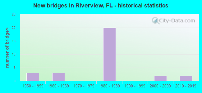
- New bridges - historical statistics
- 31950-1959
- 31960-1969
- 201980-1989
- 22000-2009
- 22010-2019

- Reconstructed bridges - Historical Statistics
- 11970-1979
- 01980-1989
- 21990-1999


- Bridge Condition - Deck
- 5.6%Very good
- 72.2%Good
- 11.1%Satisfactory
- 11.1%Fair

- Bridge Condition - Superstructure
- 5.6%Very good
- 88.9%Good
- 5.6%Satisfactory

- Bridge Condition - Substructure
- 5.6%Very good
- 72.2%Good
- 22.2%Satisfactory

- Bridge Condition - Channel
- 6.3%Excellent
- 6.3%Very good
- 50.0%Good
- 37.5%Satisfactory

- Bridge Condition - Culverts
- 50.0%Good
- 50.0%Satisfactory
Find on map >> Show street view
Structure Number: 30143, Location: 5.6 MI WEST OF SR-29 (Lat: 26.505086, Lng: -81.511264), Route carried "on" structure: State highway 82, Year Built: 1950, Year Reconstructed: 1979, Status: Open, Structure Length: 1.83m (6.00ft), Average Daily Traffic: 13,700 (year 2021), Truck Traffic: 13%, Average Future Daily Traffic: 23,770 (year 2041), Design Load: H 15, Features Intersected: Canal 143
Minimum Vertical Clearance: 30+ m (98+ ft), Kilometerpoint: 3.389, Lanes on structure: 2, Owner: State Highway Agency, Approaching Roadway Width: 11.7m (38.4ft), Material/Design: Concrete, Design/Construction: Slab, Number Of Spans In Main Unit: 4, Length of Maximum Span: 4.6m (15.1ft), Curb-To-Curb Width: 13.4m (44.0ft), Out-to-Out Width: 14.2m (46.6ft)
Condition: Deck: Good, Superstructure: Good, Substructure: Good, Channel: Good, Operating Rating: 41.8 metric tons, Method Used To Determine Operating Rating: Load Factor (LF), Inventory Rating: 25.0 metric tons, Method Used To Determine Inventory Rating: Load Factor (LF), Structural Evaluation: Equal to present minimum criteria, Deck Geometry: Equal to present minimum criteria, Waterway Adequacy: Equal to present desirable criteria, Approach Roadway Alignment: Equal to present desirable criteria, Length Of Structure Improvement: 1.80m (5.91ft), Designated Inspection Frequency: Every 24 months, Inspection Date: April 2021, Deck Structure Type: Concrete Cast-file-Place, Wearing Surface/Protective System: Wearing Surface: Bituminous
Find on map >> Show street view
Structure Number: 30146, Location: 13.7 MILES SE OF SR-951 (Lat: 25.959400, Lng: -81.509717), Route carried "on" structure: US 41, Year Built: 1969, Status: Open, Structure Length: 6.68m (21.92ft), Average Daily Traffic: 1,550 (year 2021), Truck Traffic: 8%, Average Future Daily Traffic: 2,689 (year 2041), Design Load: HS 20+Mod, Features Intersected: FAHKA UNION CANAL
Minimum Vertical Clearance: 30+ m (98+ ft), Kilometerpoint: 55.086, Lanes on structure: 1, Base Highway Network: Yes, Owner: State Highway Agency, Approaching Roadway Width: 9.0m (29.5ft), Material/Design: Prestressed concrete, Design/Construction: Stringer/Multi-beam, Number Of Spans In Main Unit: 4, Length of Maximum Span: 16.7m (54.8ft), Curb-To-Curb Width: 12.2m (40.0ft), Out-to-Out Width: 12.8m (42.0ft)
Condition: Deck: Good, Superstructure: Good, Substructure: Satisfactory, Channel: Very good, Operating Rating: 60.4 metric tons, Method Used To Determine Operating Rating: Load Factor (LF), Inventory Rating: 36.2 metric tons, Method Used To Determine Inventory Rating: Load Factor (LF), Structural Evaluation: Equal to present minimum criteria, Deck Geometry: Better than present minimum criteria, Waterway Adequacy: Equal to present desirable criteria, Approach Roadway Alignment: Equal to present desirable criteria, Designated Inspection Frequency: Every 24 months, Underwater Inspection Frequency: Every 24 months, Inspection Date: March 2021, Underwater Inspection Date: Febuary 2021, Deck Structure Type: Concrete Cast-file-Place
Find on map >> Show street view
Structure Number: 100009, Location: 4.1 Mi N of SR-674 (Lat: 27.773125, Lng: -82.334983), Route carried "on" structure: US 301, Year Built: 2010, Status: Open, Structure Length: 4.57m (14.99ft), Average Daily Traffic: 16,000 (year 2021), Truck Traffic: 16%, Average Future Daily Traffic: 27,760 (year 2041), Design Load: HL 93, Features Intersected: Little Bullfrog Creek
Minimum Vertical Clearance: 30+ m (98+ ft), Kilometerpoint: 15.857, Lanes on structure: 6, Base Highway Network: Yes, Owner: State Highway Agency, Approaching Roadway Width: 29.0m (95.1ft), Skew: 20 degrees, Material/Design: Prestressed concrete, Design/Construction: Slab, Number Of Spans In Main Unit: 3, Length of Maximum Span: 15.2m (49.9ft), Curb or Sidewalk Widths: Left: 1.5m (4.9ft), Right: 3.7m (12.1ft), Curb-To-Curb Width: 29.0m (95.1ft), Out-to-Out Width: 41.5m (136.2ft)
Condition: Deck: Very good, Superstructure: Very good, Substructure: Good, Channel: Good, Operating Rating: 41.5 metric tons, Method Used To Determine Operating Rating: Load and Resistance Factor (LRFR), Inventory Rating: 35.3 metric tons, Method Used To Determine Inventory Rating: Load and Resistance Factor (LRFR), Structural Evaluation: Better than present minimum criteria, Deck Geometry: Superior to present desirable criteria, Waterway Adequacy: Equal to present desirable criteria, Approach Roadway Alignment: Equal to present desirable criteria, Designated Inspection Frequency: Every 24 months, Inspection Date: March 2021, Deck Structure Type: Concrete Cast-file-Place
Find on map >> Show street view
Structure Number: 100271, Location: 0.2MI EAST OF I-75 (Lat: 27.792033, Lng: -82.352325), Route carried "on" structure: County highway , Year Built: 1954, Status: Open, Structure Length: 5.94m (19.49ft), Average Daily Traffic: 5,200 (year 2021), Truck Traffic: 5%, Average Future Daily Traffic: 6,500 (year 2041), Design Load: HS 20, Features Intersected: BULLFROG CREEK, Facility Carried by Structure: OLD BIG BEND RD.
Minimum Vertical Clearance: 30+ m (98+ ft), Kilometerpoint: 1.933, Lanes on structure: 2, Owner: County Highway Agency, Approaching Roadway Width: 7.2m (23.6ft), Material/Design: Concrete, Design/Construction: Slab, Number Of Spans In Main Unit: 13, Length of Maximum Span: 4.6m (15.1ft), Curb-To-Curb Width: 7.2m (23.6ft), Out-to-Out Width: 7.8m (25.6ft)
Condition: Deck: Satisfactory, Superstructure: Satisfactory, Substructure: Satisfactory, Channel: Good, Operating Rating: 34.6 metric tons, Method Used To Determine Operating Rating: Load Factor (LF), Inventory Rating: 20.7 metric tons, Method Used To Determine Inventory Rating: Load Factor (LF), Structural Evaluation: Somewhat better than minimum adequacy, Deck Geometry: High priority of replacement, Waterway Adequacy: Equal to present desirable criteria, Approach Roadway Alignment: Equal to present desirable criteria, Designated Inspection Frequency: Every 24 months, Inspection Date: October 2021, Deck Structure Type: Concrete Cast-file-Place
Find on map >> Show street view
Structure Number: 100357, Location: 0.5MI N OF ALAFIA RIVER (Lat: 27.864400, Lng: -82.346994), Route carried "on" structure: Interstate 75, Year Built: 1981, Status: Open, Structure Length: 4.85m (15.91ft), Average Daily Traffic: 71,750 (year 2020), Truck Traffic: 12%, Average Future Daily Traffic: 124,486 (year 2042), Design Load: HS 20+Mod, Features Intersected: RIVERVIEW DRIVE
Minimum Vertical Clearance: 30+ m (98+ ft), Kilometerpoint: 27.933, Lanes on structure: 4, Lanes under structure: 2, Base Highway Network: Yes, Owner: State Highway Agency, Approaching Roadway Width: 20.7m (67.9ft), Material/Design: Prestressed concrete, Design/Construction: Stringer/Multi-beam, Number Of Spans In Main Unit: 3, Length of Maximum Span: 25.3m (83.0ft), Curb-To-Curb Width: 20.7m (67.9ft), Out-to-Out Width: 21.6m (70.9ft)
Condition: Deck: Good, Superstructure: Good, Substructure: Good, Operating Rating: 63.5 metric tons, Method Used To Determine Operating Rating: Allowable Stress (AS), Inventory Rating: 52.6 metric tons, Method Used To Determine Inventory Rating: Allowable Stress (AS), Structural Evaluation: Better than present minimum criteria, Deck Geometry: Equal to present minimum criteria, Underclear: Superior to present desirable criteria, Approach Roadway Alignment: Equal to present desirable criteria, Designated Inspection Frequency: Every 24 months, Inspection Date: September 2021, Deck Structure Type: Concrete Precast Panels, Wearing Surface/Protective System: Wearing Surface: Integral Concrete
Find on map >> Show street view
Structure Number: 100358, Location: 0.3 MI N OF GIBSONTON DR (Lat: 27.857361, Lng: -82.347000), Route carried "on" structure: Interstate 75, Year Built: 1981, Status: Open, Structure Length: 47.40m (155.51ft), Average Daily Traffic: 71,750 (year 2020), Truck Traffic: 12%, Average Future Daily Traffic: 124,486 (year 2042), Design Load: HS 20+Mod, Features Intersected: ALAFIA RIVER
Minimum Vertical Clearance: 30+ m (98+ ft), Kilometerpoint: 27.011, Lanes on structure: 4, Base Highway Network: Yes, Owner: State Highway Agency, Approaching Roadway Width: 20.9m (68.6ft), Skew: 2 degrees, Navigation Control: Yes ( Vertical Clearance: 8.0m (26.2ft), Horizontal Clearance: 16.0m (52.5ft)), Material/Design: Prestressed concrete, Design/Construction: Stringer/Multi-beam, Number Of Spans In Main Unit: 21, Length of Maximum Span: 27.5m (90.2ft), Curb-To-Curb Width: 20.9m (68.6ft), Out-to-Out Width: 21.8m (71.5ft)
Condition: Deck: Fair, Superstructure: Good, Substructure: Good, Channel: Excellent, Operating Rating: 59.9 metric tons, Method Used To Determine Operating Rating: Load Factor (LF), Inventory Rating: 51.7 metric tons, Method Used To Determine Inventory Rating: Load Factor (LF), Structural Evaluation: Better than present minimum criteria, Deck Geometry: Better than present minimum criteria, Waterway Adequacy: Equal to present desirable criteria, Approach Roadway Alignment: Equal to present desirable criteria, Length Of Structure Improvement: 4.73m (15.52ft), Designated Inspection Frequency: Every 24 months, Underwater Inspection Frequency: Every 24 months, Inspection Date: September 2021, Underwater Inspection Date: August 2021, Bridge Improvement Cost: $387,000, Roadway Improvement Cost: $39,000, Total Project Cost: $426,000, Deck Structure Type: Concrete Precast Panels
Find on map >> Show street view
Structure Number: 100359, Location: 0.3 MI N OF GIBSONTON DR (Lat: 27.857425, Lng: -82.346578), Route carried "on" structure: Interstate 75, Year Built: 1981, Status: Open, Structure Length: 47.40m (155.51ft), Average Daily Traffic: 71,750 (year 2020), Truck Traffic: 12%, Average Future Daily Traffic: 124,486 (year 2042), Design Load: HS 20+Mod, Features Intersected: ALAFIA RIVER
Minimum Vertical Clearance: 30+ m (98+ ft), Kilometerpoint: 27.032, Lanes on structure: 4, Base Highway Network: Yes, Owner: State Highway Agency, Approaching Roadway Width: 20.9m (68.6ft), Skew: 2 degrees, Navigation Control: Yes ( Vertical Clearance: 8.0m (26.2ft), Horizontal Clearance: 16.0m (52.5ft)), Material/Design: Prestressed concrete, Design/Construction: Stringer/Multi-beam, Number Of Spans In Main Unit: 21, Length of Maximum Span: 27.5m (90.2ft), Curb-To-Curb Width: 20.9m (68.6ft), Out-to-Out Width: 21.8m (71.5ft)
Condition: Deck: Fair, Superstructure: Good, Substructure: Good, Channel: Satisfactory, Operating Rating: 59.9 metric tons, Method Used To Determine Operating Rating: Load Factor (LF), Inventory Rating: 51.7 metric tons, Method Used To Determine Inventory Rating: Load Factor (LF), Structural Evaluation: Better than present minimum criteria, Deck Geometry: Better than present minimum criteria, Waterway Adequacy: Equal to present desirable criteria, Approach Roadway Alignment: Equal to present desirable criteria, Length Of Structure Improvement: 4.73m (15.52ft), Designated Inspection Frequency: Every 24 months, Underwater Inspection Frequency: Every 24 months, Inspection Date: September 2021, Underwater Inspection Date: August 2021, Bridge Improvement Cost: $282,000, Roadway Improvement Cost: $28,000, Total Project Cost: $310,000, Deck Structure Type: Concrete Precast Panels
Find on map >> Show street view
Structure Number: 100363, Location: 2 MI EAST OF US-41 (Lat: 27.791869, Lng: -82.356836), Route carried "on" structure: Interstate 75, Year Built: 1981, Year Reconstructed: 2004, Status: Open, Structure Length: 9.61m (31.53ft), Average Daily Traffic: 47,000 (year 2020), Truck Traffic: 11%, Average Future Daily Traffic: 81,545 (year 2042), Design Load: HS 20+Mod, Features Intersected: CR-672 & OLD BIG BEND RD
Minimum Vertical Clearance: 30+ m (98+ ft), Kilometerpoint: 19.758, Lanes on structure: 4, Lanes under structure: 7, Base Highway Network: Yes, Owner: State Highway Agency, Approaching Roadway Width: 19.5m (64.0ft), Skew: 1 degrees, Material/Design: Prestressed concrete, Design/Construction: Stringer/Multi-beam, Number Of Spans In Main Unit: 5, Length of Maximum Span: 23.9m (78.4ft), Curb-To-Curb Width: 19.5m (64.0ft), Out-to-Out Width: 20.5m (67.3ft)
Condition: Deck: Good, Superstructure: Good, Substructure: Good, Operating Rating: 37.9 metric tons, Method Used To Determine Operating Rating: Load and Resistance Factor (LRFR), Inventory Rating: 33.9 metric tons, Method Used To Determine Inventory Rating: Load and Resistance Factor (LRFR), Structural Evaluation: Better than present minimum criteria, Deck Geometry: Somewhat better than minimum adequacy, Underclear: Equal to present minimum criteria, Approach Roadway Alignment: Equal to present desirable criteria, Designated Inspection Frequency: Every 24 months, Inspection Date: September 2021, Deck Structure Type: Concrete Cast-file-Place
Find on map >> Show street view
Structure Number: 100364, Location: 2 MI EAST OF US-41 (Lat: 27.791867, Lng: -82.356428), Route carried "on" structure: Interstate 75, Year Built: 1981, Year Reconstructed: 2004, Status: Open, Structure Length: 9.62m (31.56ft), Average Daily Traffic: 47,000 (year 2020), Truck Traffic: 11%, Average Future Daily Traffic: 81,545 (year 2042), Design Load: HS 20+Mod, Features Intersected: CR-672 & OLD BIG BEND RD
Minimum Vertical Clearance: 30+ m (98+ ft), Kilometerpoint: 19.766, Lanes on structure: 4, Lanes under structure: 7, Base Highway Network: Yes, Owner: State Highway Agency, Approaching Roadway Width: 19.6m (64.3ft), Skew: 1 degrees, Material/Design: Prestressed concrete, Design/Construction: Stringer/Multi-beam, Number Of Spans In Main Unit: 5, Length of Maximum Span: 23.9m (78.4ft), Curb-To-Curb Width: 19.6m (64.3ft), Out-to-Out Width: 20.7m (67.9ft)
Condition: Deck: Good, Superstructure: Good, Substructure: Good, Operating Rating: 35.9 metric tons, Method Used To Determine Operating Rating: Load and Resistance Factor (LRFR), Inventory Rating: 32.3 metric tons, Method Used To Determine Inventory Rating: Load and Resistance Factor (LRFR), Structural Evaluation: Better than present minimum criteria, Deck Geometry: Somewhat better than minimum adequacy, Underclear: Equal to present minimum criteria, Approach Roadway Alignment: Equal to present desirable criteria, Designated Inspection Frequency: Every 24 months, Inspection Date: September 2021, Deck Structure Type: Concrete Cast-file-Place
Find on map >> Show street view
Structure Number: 100365, Location: 0.3 MI EAST OF I-75 (Lat: 27.791708, Lng: -82.352472), Route carried "on" structure: County highway 672, Year Built: 1980, Status: Open, Structure Length: 6.87m (22.54ft), Average Daily Traffic: 33,500 (year 2020), Truck Traffic: 13%, Average Future Daily Traffic: 58,122 (year 2042), Design Load: HS 20+Mod, Features Intersected: BULLFROG CREEK
Minimum Vertical Clearance: 30+ m (98+ ft), Kilometerpoint: 4.709, Lanes on structure: 6, Owner: State Highway Agency, Approaching Roadway Width: 25.6m (84.0ft), Skew: 32 degrees, Material/Design: Prestressed concrete, Design/Construction: Slab, Number Of Spans In Main Unit: 6, Length of Maximum Span: 11.5m (37.7ft), Curb-To-Curb Width: 34.7m (113.8ft), Out-to-Out Width: 36.2m (118.8ft)
Condition: Deck: Satisfactory, Superstructure: Good, Substructure: Good, Channel: Good, Operating Rating: 61.4 metric tons, Method Used To Determine Operating Rating: Load and Resistance Factor (LRFR), Inventory Rating: 34.7 metric tons, Method Used To Determine Inventory Rating: Load and Resistance Factor (LRFR), Structural Evaluation: Better than present minimum criteria, Deck Geometry: Superior to present desirable criteria, Waterway Adequacy: Equal to present desirable criteria, Approach Roadway Alignment: Equal to present desirable criteria, Designated Inspection Frequency: Every 24 months, Inspection Date: September 2021, Deck Structure Type: Concrete Precast Panels
Find on map >> Show street view
Structure Number: 100374, Location: 0.7 MI NORTH OF SYMMES RD (Lat: 27.844097, Lng: -82.347450), Route carried "on" structure: Interstate 75, Year Built: 1983, Status: Open, Structure Length: 12.64m (41.47ft), Average Daily Traffic: 56,500 (year 2020), Truck Traffic: 11%, Average Future Daily Traffic: 98,028 (year 2042), Design Load: HS 20+Mod, Features Intersected: BULLFROG CREEK
Minimum Vertical Clearance: 30+ m (98+ ft), Kilometerpoint: 25.634, Lanes on structure: 3, Base Highway Network: Yes, Owner: State Highway Agency, Approaching Roadway Width: 17.2m (56.4ft), Skew: 3 degrees, Material/Design: Prestressed concrete, Design/Construction: Stringer/Multi-beam, Number Of Spans In Main Unit: 6, Length of Maximum Span: 21.0m (68.9ft), Curb-To-Curb Width: 17.2m (56.4ft), Out-to-Out Width: 18.3m (60.0ft)
Condition: Deck: Good, Superstructure: Good, Substructure: Good, Channel: Satisfactory, Operating Rating: 51.7 metric tons, Method Used To Determine Operating Rating: Allowable Stress (AS), Inventory Rating: 45.4 metric tons, Method Used To Determine Inventory Rating: Allowable Stress (AS), Structural Evaluation: Better than present minimum criteria, Deck Geometry: Better than present minimum criteria, Waterway Adequacy: Equal to present desirable criteria, Approach Roadway Alignment: Equal to present desirable criteria, Designated Inspection Frequency: Every 24 months, Underwater Inspection Frequency: Every 24 months, Inspection Date: September 2021, Underwater Inspection Date: August 2021, Deck Structure Type: Concrete Cast-file-Place
Find on map >> Show street view
Structure Number: 100376, Location: 3 MILES NORTH OF CR-672 (Lat: 27.835186, Lng: -82.349350), Route carried "on" structure: Interstate 75, Year Built: 1983, Status: Open, Structure Length: 5.04m (16.54ft), Average Daily Traffic: 56,500 (year 2020), Truck Traffic: 11%, Average Future Daily Traffic: 98,028 (year 2042), Design Load: HS 20+Mod, Features Intersected: SYMMES ROAD
Minimum Vertical Clearance: 30+ m (98+ ft), Kilometerpoint: 24.662, Lanes on structure: 3, Lanes under structure: 2, Base Highway Network: Yes, Owner: State Highway Agency, Approaching Roadway Width: 17.2m (56.4ft), Skew: 2 degrees, Material/Design: Prestressed concrete, Design/Construction: Stringer/Multi-beam, Number Of Spans In Main Unit: 3, Length of Maximum Span: 27.2m (89.2ft), Curb-To-Curb Width: 17.2m (56.4ft), Out-to-Out Width: 18.1m (59.4ft)
Condition: Deck: Good, Superstructure: Good, Substructure: Good, Operating Rating: 57.2 metric tons, Method Used To Determine Operating Rating: Allowable Stress (AS), Inventory Rating: 47.2 metric tons, Method Used To Determine Inventory Rating: Allowable Stress (AS), Structural Evaluation: Better than present minimum criteria, Deck Geometry: Better than present minimum criteria, Underclear: Superior to present desirable criteria, Approach Roadway Alignment: Equal to present desirable criteria, Designated Inspection Frequency: Every 24 months, Inspection Date: September 2021, Deck Structure Type: Concrete Cast-file-Place
Find on map >> Show street view
Structure Number: 100377, Location: 2.2MI EAST OF US-41 (Lat: 27.851833, Lng: -82.346556), Route carried "on" structure: County highway , Year Built: 1983, Status: Open, Structure Length: 10.24m (33.60ft), Average Daily Traffic: 140,000 (year 2021), Truck Traffic: 10%, Average Future Daily Traffic: 170,000 (year 2041), Design Load: HS 20+Mod, Features Intersected: I-75 (SR-93), Facility Carried by Structure: GIBSONTON DRIVE
Minimum Vertical Clearance: 30+ m (98+ ft), Kilometerpoint: 0.000, Lanes on structure: 4, Lanes under structure: 6, Owner: State Highway Agency, Approaching Roadway Width: 21.6m (70.9ft), Skew: 23 degrees, Material/Design: Steel continuous, Design/Construction: Stringer/Multi-beam, Number Of Spans In Main Unit: 2, Length of Maximum Span: 51.2m (168.0ft), Curb-To-Curb Width: 21.6m (70.9ft), Out-to-Out Width: 28.2m (92.5ft)
Condition: Deck: Good, Superstructure: Good, Substructure: Good, Operating Rating: 55.3 metric tons, Method Used To Determine Operating Rating: Load Factor (LF), Inventory Rating: 33.6 metric tons, Method Used To Determine Inventory Rating: Load Factor (LF), Structural Evaluation: Better than present minimum criteria, Deck Geometry: Superior to present desirable criteria, Underclear: Somewhat better than minimum adequacy, Approach Roadway Alignment: Equal to present desirable criteria, Designated Inspection Frequency: Every 24 months, Inspection Date: September 2021, Deck Structure Type: Concrete Precast Panels
Find on map >> Show street view
Structure Number: 100382, Location: 0.3MI SOUTH OF I-75 (Lat: 27.898189, Lng: -82.341025), Route carried "on" structure: US 301, Year Built: 1985, Status: Open, Structure Length: 0.63m (2.07ft), Average Daily Traffic: 50,000 (year 2020), Truck Traffic: 6%, Average Future Daily Traffic: 86,750 (year 2042), Design Load: HS 20+Mod, Features Intersected: ARCHIE CREEK
Minimum Vertical Clearance: 30+ m (98+ ft), Kilometerpoint: 30.339, Lanes on structure: 10, Base Highway Network: Yes, Owner: State Highway Agency, Approaching Roadway Width: 50.0m (164.0ft), Skew: 10 degrees, Material/Design: Concrete, Design/Construction: Culvert, Number Of Spans In Main Unit: 2, Length of Maximum Span: 3.2m (10.5ft)
Condition: Channel: Satisfactory, Culverts: Satisfactory, Structural Evaluation: Equal to present minimum criteria, Waterway Adequacy: Superior to present desirable criteria, Approach Roadway Alignment: Equal to present desirable criteria, Designated Inspection Frequency: Every 24 months, Inspection Date: March 2021
Find on map >> Show street view
Structure Number: 100486, Location: 2MI SOUTH OF SR-618 (Lat: 27.903008, Lng: -82.343667), Route carried "on" structure: Interstate 75, Year Built: 1985, Status: Open, Structure Length: 9.75m (31.99ft), Average Daily Traffic: 71,750 (year 2021), Truck Traffic: 12%, Average Future Daily Traffic: 124,486 (year 2041), Design Load: HS 20+Mod, Features Intersected: US-301 (SR-43)
Minimum Vertical Clearance: 30+ m (98+ ft), Kilometerpoint: 32.298, Lanes on structure: 5, Lanes under structure: 8, Base Highway Network: Yes, Owner: State Highway Agency, Approaching Roadway Width: 24.4m (80.1ft), Skew: 3 degrees, Material/Design: Prestressed concrete, Design/Construction: Stringer/Multi-beam, Number Of Spans In Main Unit: 4, Length of Maximum Span: 34.6m (113.5ft), Curb-To-Curb Width: 24.4m (80.1ft), Out-to-Out Width: 25.3m (83.0ft)
Condition: Deck: Good, Superstructure: Good, Substructure: Very good, Operating Rating: 57.2 metric tons, Method Used To Determine Operating Rating: Load Factor (LF), Inventory Rating: 34.2 metric tons, Method Used To Determine Inventory Rating: Load Factor (LF), Structural Evaluation: Better than present minimum criteria, Deck Geometry: Equal to present minimum criteria, Underclear: Better than present minimum criteria, Approach Roadway Alignment: Equal to present desirable criteria, Designated Inspection Frequency: Every 24 months, Inspection Date: October 2021, Deck Structure Type: Concrete Cast-file-Place
Find on map >> Show street view
Structure Number: 100736, Location: 0.8 mi N of Big Bend Rd. (Lat: 27.803875, Lng: -82.334336), Route carried "on" structure: US 301, Year Built: 2010, Status: Open, Structure Length: 3.20m (10.50ft), Average Daily Traffic: 50,500 (year 2021), Truck Traffic: 6%, Average Future Daily Traffic: 87,618 (year 2041), Design Load: HL 93, Features Intersected: Tadpole Creek
Minimum Vertical Clearance: 30+ m (98+ ft), Kilometerpoint: 19.272, Lanes on structure: 7, Base Highway Network: Yes, Owner: State Highway Agency, Approaching Roadway Width: 33.8m (110.9ft), Skew: 23 degrees, Material/Design: Prestressed concrete, Design/Construction: Slab, Number Of Spans In Main Unit: 3, Length of Maximum Span: 10.7m (35.1ft), Curb or Sidewalk Widths: Left: 1.5m (4.9ft), Right: 3.7m (12.1ft), Curb-To-Curb Width: 33.8m (110.9ft), Out-to-Out Width: 41.5m (136.2ft)
Condition: Deck: Good, Superstructure: Good, Substructure: Good, Channel: Good, Operating Rating: 59.8 metric tons, Method Used To Determine Operating Rating: Load and Resistance Factor (LRFR), Inventory Rating: 51.3 metric tons, Method Used To Determine Inventory Rating: Load and Resistance Factor (LRFR), Structural Evaluation: Better than present minimum criteria, Deck Geometry: Superior to present desirable criteria, Waterway Adequacy: Equal to present desirable criteria, Approach Roadway Alignment: Equal to present desirable criteria, Designated Inspection Frequency: Every 24 months, Inspection Date: March 2021, Deck Structure Type: Concrete Cast-file-Place
Find on map >> Show street view
Structure Number: 104312, Location: 0.6MI E OF BALM RIVERVIEW (Lat: 27.864331, Lng: -82.314994), Route carried "on" structure: County highway , Year Built: 1960, Status: Open, Structure Length: 1.85m (6.07ft), Average Daily Traffic: 6,480 (year 2020), Truck Traffic: 5%, Average Future Daily Traffic: 7,776 (year 2040), Design Load: H 15, Features Intersected: RICE CREEK, Facility Carried by Structure: McMULLEN LOOP
Minimum Vertical Clearance: 30+ m (98+ ft), Kilometerpoint: 0.000, Lanes on structure: 2, Owner: County Highway Agency, Approaching Roadway Width: 6.3m (20.7ft), Material/Design: Prestressed concrete, Design/Construction: Channel Beam, Number Of Spans In Main Unit: 3, Length of Maximum Span: 6.1m (20.0ft), Curb-To-Curb Width: 8.7m (28.5ft), Out-to-Out Width: 9.2m (30.2ft)
Condition: Deck: Good, Superstructure: Good, Substructure: Satisfactory, Channel: Good, Operating Rating: 43.2 metric tons, Method Used To Determine Operating Rating: Load Factor (LF), Inventory Rating: 25.9 metric tons, Method Used To Determine Inventory Rating: Load Factor (LF), Structural Evaluation: Equal to present minimum criteria, Deck Geometry: High priority of replacement, Waterway Adequacy: Better than present minimum criteria, Approach Roadway Alignment: Somewhat better than minimum adequacy, Designated Inspection Frequency: Every 24 months, Inspection Date: April 2020, Deck Structure Type: Concrete Cast-file-Place, Wearing Surface/Protective System: Wearing Surface: Bituminous
Find on map >> Show street view
Structure Number: 104335, Location: 1.2MI S OF BOYETTE ROAD (Lat: 27.803589, Lng: -82.241000), Route carried "on" structure: County highway , Year Built: 1966, Status: Open, Structure Length: 1.84m (6.04ft), Average Daily Traffic: 970 (year 2020), Truck Traffic: 5%, Average Future Daily Traffic: 1,212 (year 2040), Design Load: H 15, Features Intersected: BELL CREEK, Facility Carried by Structure: BALM BOYETTE RD
Minimum Vertical Clearance: 30.45m (99.90ft), Kilometerpoint: 4.794, Lanes on structure: 2, Owner: County Highway Agency, Approaching Roadway Width: 6.4m (21.0ft), Material/Design: Prestressed concrete, Design/Construction: Channel Beam, Number Of Spans In Main Unit: 2, Length of Maximum Span: 9.2m (30.2ft), Curb or Sidewalk Widths: Left: 0.6m (2.0ft), Right: 0.6m (2.0ft), Curb-To-Curb Width: 7.9m (25.9ft), Out-to-Out Width: 9.8m (32.2ft)
Condition: Deck: Good, Superstructure: Good, Substructure: Satisfactory, Channel: Good, Operating Rating: 44.1 metric tons, Method Used To Determine Operating Rating: Load Factor (LF), Inventory Rating: 26.4 metric tons, Method Used To Determine Inventory Rating: Load Factor (LF), Structural Evaluation: Equal to present minimum criteria, Deck Geometry: Somewhat better than minimum adequacy, Waterway Adequacy: Equal to present desirable criteria, Approach Roadway Alignment: Better than present minimum criteria, Designated Inspection Frequency: Every 24 months, Underwater Inspection Frequency: Every 24 months, Inspection Date: April 2020, Underwater Inspection Date: March 2020, Deck Structure Type: Concrete Cast-file-Place, Wearing Surface/Protective System: Wearing Surface: Bituminous
Find on map >> Show street view
Structure Number: 104351, Location: 0.5MI NORTH OF BOYETTE RD (Lat: 27.857539, Lng: -82.318903), Route carried "on" structure: County highway , Year Built: 1954, Status: Open, Structure Length: 1.04m (3.41ft), Average Daily Traffic: 11,740 (year 2020), Truck Traffic: 1%, Average Future Daily Traffic: 14,088 (year 2040), Features Intersected: RICE CREEK, Facility Carried by Structure: BALM RIVERVIEW RD
Minimum Vertical Clearance: 30+ m (98+ ft), Kilometerpoint: 1.196, Lanes on structure: 2, Owner: County Highway Agency, Approaching Roadway Width: 6.7m (22.0ft), Material/Design: Steel, Design/Construction: Culvert, Number Of Spans In Main Unit: 2, Length of Maximum Span: 5.2m (17.1ft), Out-to-Out Width: 7.7m (25.3ft)
Condition: Channel: Satisfactory, Culverts: Good, Operating Rating: 36.1 metric tons, Method Used To Determine Operating Rating: Allowable Stress (AS), Inventory Rating: 26.5 metric tons, Method Used To Determine Inventory Rating: Allowable Stress (AS), Structural Evaluation: Equal to present minimum criteria, Waterway Adequacy: Equal to present minimum criteria, Approach Roadway Alignment: Better than present minimum criteria, Designated Inspection Frequency: Every 24 months, Inspection Date: April 2020
Find on map >> Show street view
Structure Number: 104361, Location: 4.9MI EAST OF US-301 (Lat: 27.823025, Lng: -82.253558), Route carried "on" structure: County highway , Year Built: 1989, Status: Open, Structure Length: 0.67m (2.20ft), Average Daily Traffic: 1,211 (year 2020), Truck Traffic: 2%, Average Future Daily Traffic: 1,453 (year 2040), Features Intersected: BELL CREEK, Facility Carried by Structure: RHODINE RD
Minimum Vertical Clearance: 30+ m (98+ ft), Kilometerpoint: 0.000, Lanes on structure: 2, Owner: County Highway Agency, Approaching Roadway Width: 7.1m (23.3ft), Material/Design: Aluminum, Iron, Design/Construction: Culvert, Number Of Spans In Main Unit: 1, Length of Maximum Span: 6.7m (22.0ft)
Condition: Channel: Satisfactory, Culverts: Satisfactory, Structural Evaluation: Equal to present minimum criteria, Waterway Adequacy: Better than present minimum criteria, Approach Roadway Alignment: Better than present minimum criteria, Designated Inspection Frequency: Every 24 months, Underwater Inspection Frequency: Every 24 months, Inspection Date: April 2020, Underwater Inspection Date: March 2020
Find on map >> Show street view
Structure Number: 104702, Location: 1.1MI W OF US-301 (Lat: 27.835206, Lng: -82.346203), Route carried "on" structure: County highway , Year Built: 2005, Status: Open, Structure Length: 3.90m (12.80ft), Average Daily Traffic: 5,482 (year 2020), Truck Traffic: 5%, Average Future Daily Traffic: 65,784 (year 2040), Design Load: HL 93, Features Intersected: BULLFROG CREEK, Facility Carried by Structure: SYMMES ROAD
Minimum Vertical Clearance: 30+ m (98+ ft), Kilometerpoint: 3.483, Lanes on structure: 2, Owner: County Highway Agency, Approaching Roadway Width: 12.0m (39.4ft), Skew: 1 degrees, Material/Design: Concrete continuous, Design/Construction: Slab, Number Of Spans In Main Unit: 4, Length of Maximum Span: 10.7m (35.1ft), Curb or Sidewalk Widths: Left: 1.6m (5.2ft), Right: 1.6m (5.2ft), Curb-To-Curb Width: 12.0m (39.4ft), Out-to-Out Width: 16.9m (55.4ft)
Condition: Deck: Good, Superstructure: Good, Substructure: Good, Channel: Satisfactory, Inventory Rating: 63.2 metric tons, Method Used To Determine Inventory Rating: Load Factor (LF), Structural Evaluation: Better than present minimum criteria, Deck Geometry: Somewhat better than minimum adequacy, Waterway Adequacy: Superior to present desirable criteria, Approach Roadway Alignment: Equal to present desirable criteria, Designated Inspection Frequency: Every 24 months, Inspection Date: April 2020, Deck Structure Type: Concrete Cast-file-Place
Find on map >> Show street view
Structure Number: 104711, Location: 0.5MI EAST OF US-301 (Lat: 27.855336, Lng: -82.319686), Route carried "on" structure: County highway , Year Built: 2005, Status: Open, Structure Length: 0.85m (2.79ft), Average Daily Traffic: 59,040 (year 2020), Truck Traffic: 3%, Average Future Daily Traffic: 70,848 (year 2040), Design Load: HL 93, Features Intersected: RICE CREEK, Facility Carried by Structure: BOYETTE RD.
Minimum Vertical Clearance: 30+ m (98+ ft), Kilometerpoint: 0.000, Lanes on structure: 7, Owner: County Highway Agency, Approaching Roadway Width: 25.8m (84.6ft), Skew: 26 degrees, Material/Design: Concrete, Design/Construction: Culvert, Number Of Spans In Main Unit: 2, Length of Maximum Span: 4.3m (14.1ft)
Condition: Channel: Good, Culverts: Good, Structural Evaluation: Better than present minimum criteria, Waterway Adequacy: Equal to present desirable criteria, Approach Roadway Alignment: Equal to present desirable criteria, Designated Inspection Frequency: Every 24 months, Inspection Date: April 2020
Find on map >> Show street view
Structure Number: 100357, Location: 0.5MI N OF ALAFIA RIVER (Lat: 27.864400, Lng: -82.346994), Route carried "under" structure: County highway , Year Built: 1981, Structure Length: 0. m, Average Daily Traffic: 6,400 (year 2020), Truck Traffic: 13%, Features Intersected: RIVERVIEW DRIVE, Facility Carried by Structure: I-75 NB
Minimum Vertical Clearance: 5.33m (17.49ft), Kilometerpoint: 3.755, Lanes on structure: 4, Lanes under structure: 2, Material/Design: Prestressed concrete, Design/Construction: Stringer/Multi-beam, Length of Maximum Span: 25.3m (83.0ft)
Find on map >> Show street view
Structure Number: 100363, Location: 2 MI EAST OF US-41 (Lat: 27.791869, Lng: -82.356836), Route carried "under" structure: County highway 672, Year Built: 1981, Structure Length: 0. m, Average Daily Traffic: 33,500 (year 2020), Truck Traffic: 13%, Features Intersected: CR-672 & OLD BIG BEND RD, Facility Carried by Structure: I-75 SB
Minimum Vertical Clearance: 4.97m (16.31ft), Kilometerpoint: 4.297, Lanes on structure: 4, Lanes under structure: 5, Material/Design: Prestressed concrete, Design/Construction: Stringer/Multi-beam, Length of Maximum Span: 23.9m (78.4ft)
Find on map >> Show street view
Structure Number: 100363, Location: 2 MI EAST OF US-41 (Lat: 27.791869, Lng: -82.356836), Route carried "under" structure: County highway , Year Built: 1981, Structure Length: 0. m, Average Daily Traffic: 1,000 (year 2020), Truck Traffic: 20%, Features Intersected: CR-672 & OLD BIG BEND RD, Facility Carried by Structure: I-75 SB
Minimum Vertical Clearance: 5.43m (17.81ft), Kilometerpoint: 1.513, Lanes on structure: 4, Lanes under structure: 2, Material/Design: Prestressed concrete, Design/Construction: Stringer/Multi-beam, Length of Maximum Span: 23.9m (78.4ft)
Find on map >> Show street view
Structure Number: 100364, Location: 2 MI EAST OF US-41 (Lat: 27.791867, Lng: -82.356428), Route carried "under" structure: County highway 672, Year Built: 1981, Structure Length: 0. m, Average Daily Traffic: 33,500 (year 2020), Truck Traffic: 13%, Features Intersected: CR-672 & OLD BIG BEND RD, Facility Carried by Structure: I-75 NB
Minimum Vertical Clearance: 4.94m (16.21ft), Kilometerpoint: 4.339, Lanes on structure: 4, Lanes under structure: 5, Material/Design: Prestressed concrete, Design/Construction: Stringer/Multi-beam, Length of Maximum Span: 23.9m (78.4ft)
Find on map >> Show street view
Structure Number: 100364, Location: 2 MI EAST OF US-41 (Lat: 27.791867, Lng: -82.356428), Route carried "under" structure: County highway , Year Built: 1981, Structure Length: 0. m, Average Daily Traffic: 1,000 (year 2020), Truck Traffic: 20%, Features Intersected: CR-672 & OLD BIG BEND RD, Facility Carried by Structure: I-75 NB
Minimum Vertical Clearance: 5.82m (19.09ft), Kilometerpoint: 1.555, Lanes on structure: 4, Lanes under structure: 2, Material/Design: Prestressed concrete, Design/Construction: Stringer/Multi-beam, Length of Maximum Span: 23.9m (78.4ft)
Find on map >> Show street view
Structure Number: 100376, Location: 3 MILES NORTH OF CR-672 (Lat: 27.835186, Lng: -82.349350), Route carried "under" structure: County highway , Year Built: 1983, Structure Length: 0. m, Average Daily Traffic: 6,600 (year 2020), Truck Traffic: 9%, Features Intersected: SYMMES ROAD, Facility Carried by Structure: I-75 NB
Minimum Vertical Clearance: 5.06m (16.60ft), Kilometerpoint: 3.183, Lanes on structure: 3, Lanes under structure: 2, Material/Design: Prestressed concrete, Design/Construction: Stringer/Multi-beam, Length of Maximum Span: 27.2m (89.2ft)
Find on map >> Show street view
Structure Number: 100377, Location: 2.2MI EAST OF US-41 (Lat: 27.851833, Lng: -82.346556), Route carried "under" structure: Interstate 75, Year Built: 1983, Structure Length: 0. m, Average Daily Traffic: 113,000 (year 2021), Truck Traffic: 11%, Features Intersected: I-75 (SR-93), Facility Carried by Structure: GIBSONTON DRIVE
Minimum Vertical Clearance: 4.94m (16.21ft), Kilometerpoint: 26.545, Lanes on structure: 4, Lanes under structure: 6, Material/Design: Steel continuous, Design/Construction: Stringer/Multi-beam, Length of Maximum Span: 51.2m (168.0ft)
Find on map >> Show street view
Structure Number: 100486, Location: 2MI SOUTH OF SR-618 (Lat: 27.903008, Lng: -82.343667), Route carried "under" structure: US 301, Year Built: 1985, Structure Length: 0. m, Average Daily Traffic: 50,000 (year 2021), Truck Traffic: 6%, Features Intersected: US-301 (SR-43), Facility Carried by Structure: I-75 NB
Minimum Vertical Clearance: 4.94m (16.21ft), Kilometerpoint: 30.925, Lanes on structure: 5, Lanes under structure: 8, Material/Design: Prestressed concrete, Design/Construction: Stringer/Multi-beam, Length of Maximum Span: 34.6m (113.5ft)