Bridge Statistics for Rancho Santa Margarita, California (CA)
Condition, Traffic, Stress, Structural Evaluation, Project Costs
- National Bridge Inventory (NBI) Statistics
- 37Number of bridges
- 1,099ft / 335mTotal length
- 626,500Total average daily traffic
- 13,941Total average daily truck traffic
- National Bridge Inventory (NBI) Registered Bridges for Rancho Santa Margarita
- No street view available for this location
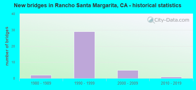
- New bridges - historical statistics
- 21980-1989
- 291990-1999
- 52000-2009
- 12010-2019


- Bridge Condition - Deck
- 7.7%Very good
- 65.4%Good
- 26.9%Fair

- Bridge Condition - Superstructure
- 7.7%Very good
- 80.8%Good
- 11.5%Fair

- Bridge Condition - Substructure
- 7.7%Very good
- 42.3%Good
- 3.8%Satisfactory
- 46.2%Fair

- Bridge Condition - Channel
- 54.5%Very good
- 45.5%Satisfactory
Find on map >> Show street view
Structure Number: 55 0691H, Location: 12-ORA-005-33.85-ORA (Lat: 33.777075, Lng: -117.873261), Route carried "on" structure: Ramp Interstate 5, Year Built: 1994, Status: Open, Structure Length: 3.35m (10.99ft), Average Daily Traffic: 52,710 (year 2016), Truck Traffic: 3%, Average Future Daily Traffic: 63,432 (year 2041), Design Load: HS 20+Mod, Features Intersected: N5-W22 CONNECTOR RAMP
Minimum Vertical Clearance: 30+ m (98+ ft), Kilometerpoint: 33.850, Lanes on structure: 2, Lanes under structure: 2, Base Highway Network: Yes, Owner: State Highway Agency, Approaching Roadway Width: 11.9m (39.0ft), Skew: 2 degrees, Material/Design: Prestressed concrete continuous, Design/Construction: Box Beam or Girders - Multiple, Number Of Spans In Main Unit: 1, Length of Maximum Span: 32.9m (107.9ft), Curb-To-Curb Width: 11.9m (39.0ft), Out-to-Out Width: 13.0m (42.7ft)
Condition: Deck: Fair, Superstructure: Good, Substructure: Fair, Operating Rating: 54.1 metric tons, Method Used To Determine Operating Rating: Assigned rating based on Load Factor Design (LFD) reported in metric tons, Inventory Rating: 32.4 metric tons, Method Used To Determine Inventory Rating: Assigned rating based on Load Factor Design (LFD) reported in metric tons, Structural Evaluation: Somewhat better than minimum adequacy, Deck Geometry: Superior to present desirable criteria, Underclear: Equal to present desirable criteria, Approach Roadway Alignment: Equal to present desirable criteria, Designated Inspection Frequency: Every 24 months, Inspection Date: November 2021, Deck Structure Type: Concrete Cast-file-Place
Find on map >> Show street view
Structure Number: 55 0697, Location: 12-ORA-241-17.60-RSM (Lat: 33.629356, Lng: -117.599536), Route carried "on" structure: City street , Year Built: 1998, Status: Open, Structure Length: 8.75m (28.71ft), Average Daily Traffic: 10,000 (year 2012), Truck Traffic: 3%, Average Future Daily Traffic: 11,222 (year 2040), Design Load: HS 20+Mod, Features Intersected: STATE ROUTE 241, Facility Carried by Structure: ANTONIO PARKWAY
Minimum Vertical Clearance: 30+ m (98+ ft), Kilometerpoint: 0.000, Lanes on structure: 8, Lanes under structure: 5, Owner: State Highway Agency, Approaching Roadway Width: 37.0m (121.4ft), Skew: 2 degrees, Material/Design: Prestressed concrete continuous, Design/Construction: Box Beam or Girders - Multiple, Number Of Spans In Main Unit: 2, Length of Maximum Span: 44.8m (147.0ft), Curb or Sidewalk Widths: Left: 1.5m (4.9ft), Right: 1.5m (4.9ft), Curb-To-Curb Width: 37.0m (121.4ft), Out-to-Out Width: 43.3m (142.1ft)
Condition: Deck: Good, Superstructure: Good, Substructure: Fair, Operating Rating: 54.1 metric tons, Method Used To Determine Operating Rating: Assigned rating based on Load Factor Design (LFD) reported in metric tons, Inventory Rating: 32.4 metric tons, Method Used To Determine Inventory Rating: Assigned rating based on Load Factor Design (LFD) reported in metric tons, Structural Evaluation: Somewhat better than minimum adequacy, Deck Geometry: Superior to present desirable criteria, Underclear: Meets minimum limits, Approach Roadway Alignment: Equal to present desirable criteria, Designated Inspection Frequency: Every 24 months, Inspection Date: November 2020, Deck Structure Type: Concrete Cast-file-Place
Find on map >> Show street view
Structure Number: 55 0698, Location: 12-ORA-241-18.07-RSM (Lat: 33.636292, Lng: -117.601028), Route carried "on" structure: City street , Year Built: 2003, Status: Open, Structure Length: 8.96m (29.40ft), Average Daily Traffic: 5,000 (year 2012), Truck Traffic: 3%, Average Future Daily Traffic: 5,611 (year 2040), Design Load: HS 20+Mod, Features Intersected: STATE ROUTE 241, Facility Carried by Structure: AVENIDA DE LAS BAN
Minimum Vertical Clearance: 30+ m (98+ ft), Kilometerpoint: 0.000, Lanes on structure: 4, Lanes under structure: 6, Owner: State Highway Agency, Approaching Roadway Width: 27.0m (88.6ft), Skew: 20 degrees, Material/Design: Prestressed concrete continuous, Design/Construction: Box Beam or Girders - Multiple, Number Of Spans In Main Unit: 2, Length of Maximum Span: 46.3m (151.9ft), Curb or Sidewalk Widths: Left: 1.5m (4.9ft), Right: 1.5m (4.9ft), Curb-To-Curb Width: 27.0m (88.6ft), Out-to-Out Width: 28.0m (91.9ft)
Condition: Deck: Good, Superstructure: Good, Substructure: Fair, Operating Rating: 54.1 metric tons, Method Used To Determine Operating Rating: Assigned rating based on Load Factor Design (LFD) reported in metric tons, Inventory Rating: 32.4 metric tons, Method Used To Determine Inventory Rating: Assigned rating based on Load Factor Design (LFD) reported in metric tons, Structural Evaluation: Somewhat better than minimum adequacy, Deck Geometry: Superior to present desirable criteria, Underclear: Meets minimum limits, Approach Roadway Alignment: Equal to present desirable criteria, Designated Inspection Frequency: Every 24 months, Inspection Date: November 2020, Deck Structure Type: Concrete Cast-file-Place
Find on map >> Show street view
Structure Number: 55 0699, Location: 12-ORA-241-18.53-RSM (Lat: 33.642281, Lng: -117.604228), Route carried "on" structure: City street , Year Built: 1995, Status: Open, Structure Length: 9.60m (31.50ft), Average Daily Traffic: 20,000 (year 2012), Truck Traffic: 3%, Average Future Daily Traffic: 22,444 (year 2040), Design Load: HS 20+Mod, Features Intersected: STATE ROUTE 241, Facility Carried by Structure: STA MARGARITA PKWY
Minimum Vertical Clearance: 30+ m (98+ ft), Kilometerpoint: 0.000, Lanes on structure: 8, Lanes under structure: 5, Owner: State Highway Agency, Approaching Roadway Width: 33.5m (109.9ft), Skew: 31 degrees, Material/Design: Prestressed concrete continuous, Design/Construction: Box Beam or Girders - Multiple, Number Of Spans In Main Unit: 2, Length of Maximum Span: 49.1m (161.1ft), Curb or Sidewalk Widths: Left: 1.5m (4.9ft), Right: 1.5m (4.9ft), Curb-To-Curb Width: 33.5m (109.9ft), Out-to-Out Width: 37.2m (122.0ft)
Condition: Deck: Good, Superstructure: Good, Substructure: Fair, Operating Rating: 54.1 metric tons, Method Used To Determine Operating Rating: Assigned rating based on Load Factor Design (LFD) reported in metric tons, Inventory Rating: 32.4 metric tons, Method Used To Determine Inventory Rating: Assigned rating based on Load Factor Design (LFD) reported in metric tons, Structural Evaluation: Somewhat better than minimum adequacy, Deck Geometry: Equal to present minimum criteria, Underclear: Equal to present minimum criteria, Approach Roadway Alignment: Equal to present desirable criteria, Designated Inspection Frequency: Every 24 months, Inspection Date: November 2020, Deck Structure Type: Concrete Cast-file-Place
Find on map >> Show street view
Structure Number: 55 0700R, Location: 12-ORA-241-18.70-RSM (Lat: 33.645261, Lng: -117.604775), Route carried "on" structure: State highway 241, Year Built: 1995, Status: Open, Structure Length: 43.43m (142.49ft), Average Daily Traffic: 9,150 (year 2012), Truck Traffic: 6%, Average Future Daily Traffic: 23,000 (year 2040), Design Load: HS 20+Mod, Features Intersected: TRABUCO CREEK
Minimum Vertical Clearance: 30+ m (98+ ft), Kilometerpoint: 18.700, Lanes on structure: 5, Base Highway Network: Yes (Inventory Route: 2, Subroute: 1), Toll: On toll road, Owner: State Highway Agency, Approaching Roadway Width: 28.8m (94.5ft), Material/Design: Prestressed concrete continuous, Design/Construction: Box Beam or Girders - Multiple, Number Of Spans In Main Unit: 8, Length of Maximum Span: 56.3m (184.7ft), Curb-To-Curb Width: 28.8m (94.5ft), Out-to-Out Width: 33.5m (109.9ft)
Condition: Deck: Fair, Superstructure: Good, Substructure: Satisfactory, Channel: Very good, Operating Rating: 54.1 metric tons, Method Used To Determine Operating Rating: Assigned rating based on Load Factor Design (LFD) reported in metric tons, Inventory Rating: 32.4 metric tons, Method Used To Determine Inventory Rating: Assigned rating based on Load Factor Design (LFD) reported in metric tons, Structural Evaluation: Equal to present minimum criteria, Deck Geometry: Superior to present desirable criteria, Waterway Adequacy: Equal to present desirable criteria, Approach Roadway Alignment: Equal to present desirable criteria, Designated Inspection Frequency: Every 24 months, Inspection Date: November 2020, Deck Structure Type: Concrete Cast-file-Place
Find on map >> Show street view
Structure Number: 55 0701L, Location: 12-ORA-241-19.33-RSM (Lat: 33.651544, Lng: -117.612042), Route carried "on" structure: State highway 241, Year Built: 1995, Year Reconstructed: 2004, Status: Open, Structure Length: 5.00m (16.40ft), Average Daily Traffic: 21,000 (year 2012), Truck Traffic: 1%, Average Future Daily Traffic: 50,000 (year 2040), Design Load: HS 20+Mod, Features Intersected: MELINDA ROAD
Minimum Vertical Clearance: 30+ m (98+ ft), Kilometerpoint: 19.330, Lanes on structure: 2, Lanes under structure: 4, Base Highway Network: Yes (Inventory Route: 2, Subroute: 1), Toll: On toll road, Owner: State Highway Agency, Approaching Roadway Width: 11.9m (39.0ft), Material/Design: Prestressed concrete, Design/Construction: Box Beam or Girders - Multiple, Number Of Spans In Main Unit: 1, Length of Maximum Span: 49.1m (161.1ft), Curb-To-Curb Width: 25.6m (84.0ft), Out-to-Out Width: 26.6m (87.3ft)
Condition: Deck: Good, Superstructure: Good, Substructure: Fair, Operating Rating: 54.1 metric tons, Method Used To Determine Operating Rating: Assigned rating based on Load Factor Design (LFD) reported in metric tons, Inventory Rating: 32.4 metric tons, Method Used To Determine Inventory Rating: Assigned rating based on Load Factor Design (LFD) reported in metric tons, Structural Evaluation: Somewhat better than minimum adequacy, Deck Geometry: Superior to present desirable criteria, Underclear: Somewhat better than minimum adequacy, Approach Roadway Alignment: Equal to present desirable criteria, Designated Inspection Frequency: Every 24 months, Inspection Date: November 2020, Deck Structure Type: Concrete Cast-file-Place
Find on map >> Show street view
Structure Number: 55 0701R, Location: 12-ORA-241-19.33-RSM (Lat: 33.651889, Lng: -117.611894), Route carried "on" structure: State highway 241, Year Built: 1995, Year Reconstructed: 2004, Status: Open, Structure Length: 5.07m (16.63ft), Average Daily Traffic: 21,000 (year 2012), Truck Traffic: 1%, Average Future Daily Traffic: 50,000 (year 2040), Design Load: HS 20+Mod, Features Intersected: MELINDA ROAD
Minimum Vertical Clearance: 30+ m (98+ ft), Kilometerpoint: 19.330, Lanes on structure: 4, Lanes under structure: 5, Base Highway Network: Yes (Inventory Route: 2, Subroute: 1), Toll: On toll road, Owner: State Highway Agency, Approaching Roadway Width: 15.5m (50.9ft), Material/Design: Prestressed concrete, Design/Construction: Box Beam or Girders - Multiple, Number Of Spans In Main Unit: 1, Length of Maximum Span: 50.0m (164.0ft), Curb-To-Curb Width: 29.3m (96.1ft), Out-to-Out Width: 30.3m (99.4ft)
Condition: Deck: Good, Superstructure: Good, Substructure: Fair, Operating Rating: 54.1 metric tons, Method Used To Determine Operating Rating: Assigned rating based on Load Factor Design (LFD) reported in metric tons, Inventory Rating: 32.4 metric tons, Method Used To Determine Inventory Rating: Assigned rating based on Load Factor Design (LFD) reported in metric tons, Structural Evaluation: Somewhat better than minimum adequacy, Deck Geometry: Superior to present desirable criteria, Underclear: Somewhat better than minimum adequacy, Approach Roadway Alignment: Equal to present desirable criteria, Designated Inspection Frequency: Every 24 months, Inspection Date: November 2020, Deck Structure Type: Concrete Cast-file-Place
Find on map >> Show street view
Structure Number: 55 0702, Location: 12-ORA-241-20.12-RSM (Lat: 33.654639, Lng: -117.625144), Route carried "on" structure: County highway , Year Built: 1995, Status: Open, Structure Length: 8.99m (29.49ft), Average Daily Traffic: 10,000 (year 2012), Truck Traffic: 3%, Average Future Daily Traffic: 11,222 (year 2040), Design Load: HS 20+Mod, Features Intersected: STATE ROUTE 241, Facility Carried by Structure: LOS ALISOS BLVD
Minimum Vertical Clearance: 30+ m (98+ ft), Kilometerpoint: 0.000, Lanes on structure: 4, Lanes under structure: 4, Owner: State Highway Agency, Approaching Roadway Width: 22.0m (72.2ft), Skew: 2 degrees, Material/Design: Prestressed concrete continuous, Design/Construction: Box Beam or Girders - Multiple, Number Of Spans In Main Unit: 2, Length of Maximum Span: 46.0m (150.9ft), Curb or Sidewalk Widths: Left: 1.5m (4.9ft), Right: 1.5m (4.9ft), Curb-To-Curb Width: 22.0m (72.2ft), Out-to-Out Width: 25.6m (84.0ft)
Condition: Deck: Good, Superstructure: Good, Substructure: Fair, Operating Rating: 54.1 metric tons, Method Used To Determine Operating Rating: Assigned rating based on Load Factor Design (LFD) reported in metric tons, Inventory Rating: 32.4 metric tons, Method Used To Determine Inventory Rating: Assigned rating based on Load Factor Design (LFD) reported in metric tons, Structural Evaluation: Somewhat better than minimum adequacy, Deck Geometry: Superior to present desirable criteria, Underclear: Equal to present minimum criteria, Approach Roadway Alignment: Equal to present desirable criteria, Designated Inspection Frequency: Every 24 months, Inspection Date: November 2020, Deck Structure Type: Concrete Cast-file-Place
Find on map >> Show street view
Structure Number: 55 0715K, Location: 12-ORA-241-17.40-RSM (Lat: 33.626061, Lng: -117.600842), Route carried "on" structure: Ramp State highway 241, Year Built: 1998, Status: Open, Structure Length: 11.65m (38.22ft), Average Daily Traffic: 1,000 (year 2012), Truck Traffic: 6%, Average Future Daily Traffic: 1,224 (year 2040), Design Load: HS 20+Mod, Features Intersected: Tijeras Creek
Minimum Vertical Clearance: 30+ m (98+ ft), Kilometerpoint: 17.400, Lanes on structure: 1, Owner: State Highway Agency, Approaching Roadway Width: 11.0m (36.1ft), Skew: 3 degrees, Material/Design: Prestressed concrete continuous, Design/Construction: Box Beam or Girders - Multiple, Number Of Spans In Main Unit: 4, Length of Maximum Span: 35.8m (117.5ft), Curb-To-Curb Width: 11.0m (36.1ft), Out-to-Out Width: 12.0m (39.4ft)
Condition: Deck: Good, Superstructure: Good, Substructure: Good, Channel: Satisfactory, Operating Rating: 54.1 metric tons, Method Used To Determine Operating Rating: Assigned rating based on Load Factor Design (LFD) reported in metric tons, Inventory Rating: 32.4 metric tons, Method Used To Determine Inventory Rating: Assigned rating based on Load Factor Design (LFD) reported in metric tons, Structural Evaluation: Better than present minimum criteria, Deck Geometry: Superior to present desirable criteria, Waterway Adequacy: Equal to present minimum criteria, Approach Roadway Alignment: Equal to present desirable criteria, Designated Inspection Frequency: Every 24 months, Inspection Date: November 2020, Deck Structure Type: Concrete Cast-file-Place
Find on map >> Show street view
Structure Number: 55 0715L, Location: 12-ORA-241-17.40-RSM (Lat: 33.626111, Lng: -117.600614), Route carried "on" structure: State highway 241, Year Built: 1998, Status: Open, Structure Length: 12.25m (40.19ft), Average Daily Traffic: 4,050 (year 2012), Truck Traffic: 8%, Average Future Daily Traffic: 6,000 (year 2040), Design Load: HS 20+Mod, Features Intersected: Tijeras Creek
Minimum Vertical Clearance: 30+ m (98+ ft), Kilometerpoint: 17.400, Lanes on structure: 2, Base Highway Network: Yes (Inventory Route: 2, Subroute: 1), Owner: State Highway Agency, Approaching Roadway Width: 11.9m (39.0ft), Skew: 4 degrees, Material/Design: Prestressed concrete continuous, Design/Construction: Box Beam or Girders - Multiple, Number Of Spans In Main Unit: 4, Length of Maximum Span: 37.6m (123.4ft), Curb-To-Curb Width: 11.9m (39.0ft), Out-to-Out Width: 13.0m (42.7ft)
Condition: Deck: Good, Superstructure: Good, Substructure: Good, Channel: Satisfactory, Operating Rating: 54.1 metric tons, Method Used To Determine Operating Rating: Assigned rating based on Load Factor Design (LFD) reported in metric tons, Inventory Rating: 32.4 metric tons, Method Used To Determine Inventory Rating: Assigned rating based on Load Factor Design (LFD) reported in metric tons, Structural Evaluation: Better than present minimum criteria, Deck Geometry: Equal to present minimum criteria, Waterway Adequacy: Equal to present minimum criteria, Approach Roadway Alignment: Equal to present desirable criteria, Designated Inspection Frequency: Every 24 months, Inspection Date: November 2020, Deck Structure Type: Concrete Cast-file-Place
Find on map >> Show street view
Structure Number: 55 0715R, Location: 12-ORA-241-17.40-RSM (Lat: 33.626264, Lng: -117.599997), Route carried "on" structure: State highway 241, Year Built: 1998, Status: Open, Structure Length: 12.39m (40.65ft), Average Daily Traffic: 4,050 (year 2012), Truck Traffic: 8%, Average Future Daily Traffic: 6,000 (year 2040), Design Load: HS 20+Mod, Features Intersected: Tijeras Creek
Minimum Vertical Clearance: 30+ m (98+ ft), Kilometerpoint: 17.400, Lanes on structure: 3, Base Highway Network: Yes (Inventory Route: 2, Subroute: 1), Toll: On toll road, Owner: State Highway Agency, Approaching Roadway Width: 18.5m (60.7ft), Skew: 4 degrees, Material/Design: Prestressed concrete continuous, Design/Construction: Box Beam or Girders - Multiple, Number Of Spans In Main Unit: 4, Length of Maximum Span: 38.1m (125.0ft), Curb-To-Curb Width: 18.5m (60.7ft), Out-to-Out Width: 19.8m (65.0ft)
Condition: Deck: Good, Superstructure: Good, Substructure: Good, Channel: Satisfactory, Operating Rating: 54.1 metric tons, Method Used To Determine Operating Rating: Assigned rating based on Load Factor Design (LFD) reported in metric tons, Inventory Rating: 32.4 metric tons, Method Used To Determine Inventory Rating: Assigned rating based on Load Factor Design (LFD) reported in metric tons, Structural Evaluation: Better than present minimum criteria, Deck Geometry: Superior to present desirable criteria, Waterway Adequacy: Better than present minimum criteria, Approach Roadway Alignment: Equal to present desirable criteria, Designated Inspection Frequency: Every 24 months, Inspection Date: November 2020, Deck Structure Type: Concrete Cast-file-Place
Find on map >> Show street view
Structure Number: 55 0801, Location: 12-ORA-261-6.05-ORA (Lat: 33.782606, Lng: -117.749678), Route carried "on" structure: City street , Year Built: 1997, Status: Open, Structure Length: 11.98m (39.30ft), Average Daily Traffic: 20,000 (year 2011), Truck Traffic: 3%, Average Future Daily Traffic: 24,068 (year 2043), Design Load: HS 20+Mod, Features Intersected: STATE ROUTE 261, Facility Carried by Structure: CHAPMAN AVENUE
Minimum Vertical Clearance: 99.90m (327.76ft), Kilometerpoint: 0.000, Lanes on structure: 6, Lanes under structure: 4, Owner: State Highway Agency, Approaching Roadway Width: 35.3m (115.8ft), Material/Design: Prestressed concrete continuous, Design/Construction: Box Beam or Girders - Single/Spread, Number Of Spans In Main Unit: 3, Length of Maximum Span: 44.8m (147.0ft), Curb-To-Curb Width: 35.3m (115.8ft), Out-to-Out Width: 36.4m (119.4ft)
Condition: Deck: Fair, Superstructure: Good, Substructure: Fair, Operating Rating: 54.1 metric tons, Method Used To Determine Operating Rating: Assigned rating based on Load Factor Design (LFD) reported in metric tons, Inventory Rating: 32.4 metric tons, Method Used To Determine Inventory Rating: Assigned rating based on Load Factor Design (LFD) reported in metric tons, Structural Evaluation: Somewhat better than minimum adequacy, Deck Geometry: Superior to present desirable criteria, Underclear: Somewhat better than minimum adequacy, Approach Roadway Alignment: Equal to present desirable criteria, Designated Inspection Frequency: Every 24 months, Inspection Date: Febuary 2021, Deck Structure Type: Concrete Cast-file-Place, Wearing Surface/Protective System: Wearing Surface: Monolithic Concrete
Find on map >> Show street view
Structure Number: 55 0802, Location: 12-ORA-241-32.37-RSM (Lat: 33.781039, Lng: -117.748492), Route carried "on" structure: County highway , Year Built: 1997, Status: Open, Structure Length: 18.62m (61.09ft), Average Daily Traffic: 20,000 (year 2012), Truck Traffic: 3%, Average Future Daily Traffic: 24,472 (year 2040), Design Load: HS 20+Mod, Features Intersected: STATE ROUTE 241, Facility Carried by Structure: SANTIAGO CANYON RD
Minimum Vertical Clearance: 30+ m (98+ ft), Kilometerpoint: 0.000, Lanes on structure: 4, Lanes under structure: 4, Base Highway Network: Yes, Toll: On toll road, Owner: State Highway Agency, Approaching Roadway Width: 18.3m (60.0ft), Skew: 5 degrees, Material/Design: Prestressed concrete continuous, Design/Construction: Box Beam or Girders - Multiple, Number Of Spans In Main Unit: 4, Length of Maximum Span: 61.0m (200.1ft), Curb-To-Curb Width: 18.3m (60.0ft), Out-to-Out Width: 19.4m (63.6ft)
Condition: Deck: Good, Superstructure: Good, Substructure: Fair, Operating Rating: 54.1 metric tons, Method Used To Determine Operating Rating: Assigned rating based on Load Factor Design (LFD) reported in metric tons, Inventory Rating: 32.4 metric tons, Method Used To Determine Inventory Rating: Assigned rating based on Load Factor Design (LFD) reported in metric tons, Structural Evaluation: Somewhat better than minimum adequacy, Deck Geometry: Meets minimum limits, Underclear: Equal to present minimum criteria, Approach Roadway Alignment: Equal to present desirable criteria, Designated Inspection Frequency: Every 24 months, Inspection Date: Febuary 2021, Deck Structure Type: Concrete Cast-file-Place
Find on map >> Show street view
Structure Number: 55 0803, Location: 12-ORA-241-32.52-RSM (Lat: 33.781628, Lng: -117.748239), Route carried "on" structure: City street , Year Built: 1997, Status: Open, Structure Length: 17.37m (56.99ft), Average Daily Traffic: 9,400 (year 2012), Truck Traffic: 3%, Average Future Daily Traffic: 11,757 (year 2040), Design Load: HS 20+Mod, Features Intersected: STATE ROUTE 241, Facility Carried by Structure: SANTIAGO-N241 ONRA
Minimum Vertical Clearance: 30+ m (98+ ft), Kilometerpoint: 0.000, Lanes on structure: 2, Lanes under structure: 4, Owner: State Highway Agency, Approaching Roadway Width: 11.8m (38.7ft), Skew: 3 degrees, Material/Design: Prestressed concrete continuous, Design/Construction: Box Beam or Girders - Multiple, Number Of Spans In Main Unit: 3, Length of Maximum Span: 65.8m (215.9ft), Curb-To-Curb Width: 11.8m (38.7ft), Out-to-Out Width: 13.0m (42.7ft)
Condition: Deck: Good, Superstructure: Good, Substructure: Fair, Operating Rating: 54.1 metric tons, Method Used To Determine Operating Rating: Assigned rating based on Load Factor Design (LFD) reported in metric tons, Inventory Rating: 32.4 metric tons, Method Used To Determine Inventory Rating: Assigned rating based on Load Factor Design (LFD) reported in metric tons, Structural Evaluation: Somewhat better than minimum adequacy, Deck Geometry: Better than present minimum criteria, Underclear: Better than present minimum criteria, Approach Roadway Alignment: Equal to present desirable criteria, Designated Inspection Frequency: Every 24 months, Inspection Date: Febuary 2021, Deck Structure Type: Concrete Cast-file-Place
Find on map >> Show street view
Structure Number: 55 0823L, Location: 12-ORA-241-33.70-RSM (Lat: 33.794106, Lng: -117.733319), Route carried "on" structure: State highway 241, Year Built: 1998, Status: Open, Structure Length: 38.71m (127.00ft), Average Daily Traffic: 22,500 (year 2012), Average Future Daily Traffic: 47,500 (year 2040), Design Load: HS 20+Mod, Features Intersected: SANTIAGO CREEK
Minimum Vertical Clearance: 30+ m (98+ ft), Kilometerpoint: 33.700, Lanes on structure: 3, Base Highway Network: Yes (Inventory Route: 2, Subroute: 1), Toll: On toll road, Owner: State Highway Agency, Approaching Roadway Width: 17.0m (55.8ft), Material/Design: Prestressed concrete continuous, Design/Construction: Box Beam or Girders - Multiple, Number Of Spans In Main Unit: 6, Length of Maximum Span: 70.1m (230.0ft), Curb-To-Curb Width: 17.0m (55.8ft), Out-to-Out Width: 18.1m (59.4ft)
Condition: Deck: Good, Superstructure: Fair, Substructure: Fair, Channel: Very good, Operating Rating: 54.1 metric tons, Method Used To Determine Operating Rating: Assigned rating based on Load Factor Design (LFD) reported in metric tons, Inventory Rating: 32.4 metric tons, Method Used To Determine Inventory Rating: Assigned rating based on Load Factor Design (LFD) reported in metric tons, Structural Evaluation: Somewhat better than minimum adequacy, Deck Geometry: Equal to present minimum criteria, Waterway Adequacy: Equal to present desirable criteria, Approach Roadway Alignment: Equal to present desirable criteria, Designated Inspection Frequency: Every 24 months, Inspection Date: Febuary 2021, Deck Structure Type: Concrete Cast-file-Place
Find on map >> Show street view
Structure Number: 55 0823R, Location: 12-ORA-241-33.70-RSM (Lat: 33.793758, Lng: -117.732989), Route carried "on" structure: State highway 241, Year Built: 1998, Status: Open, Structure Length: 38.71m (127.00ft), Average Daily Traffic: 20,500 (year 2012), Truck Traffic: 2%, Average Future Daily Traffic: 26,721 (year 2040), Design Load: HS 20+Mod, Features Intersected: SANTIAGO CREEK
Minimum Vertical Clearance: 25.00m (82.02ft), Kilometerpoint: 33.700, Lanes on structure: 3, Base Highway Network: Yes (Inventory Route: 2, Subroute: 1), Toll: On toll road, Owner: State Highway Agency, Approaching Roadway Width: 17.0m (55.8ft), Material/Design: Prestressed concrete continuous, Design/Construction: Box Beam or Girders - Multiple, Number Of Spans In Main Unit: 6, Length of Maximum Span: 70.1m (230.0ft), Curb-To-Curb Width: 17.0m (55.8ft), Out-to-Out Width: 18.1m (59.4ft)
Condition: Deck: Good, Superstructure: Good, Substructure: Fair, Channel: Very good, Operating Rating: 54.1 metric tons, Method Used To Determine Operating Rating: Assigned rating based on Load Factor Design (LFD) reported in metric tons, Inventory Rating: 32.4 metric tons, Method Used To Determine Inventory Rating: Assigned rating based on Load Factor Design (LFD) reported in metric tons, Structural Evaluation: Somewhat better than minimum adequacy, Deck Geometry: Equal to present minimum criteria, Waterway Adequacy: Equal to present desirable criteria, Approach Roadway Alignment: Equal to present desirable criteria, Designated Inspection Frequency: Every 24 months, Inspection Date: Febuary 2021, Deck Structure Type: Concrete Cast-file-Place
Find on map >> Show street view
Structure Number: 55 0895, Location: 12-ORA-241-28.70-RSM (Lat: 33.736772, Lng: -117.717525), Route carried "on" structure: State highway 241, Year Built: 1997, Status: Open, Structure Length: 4.75m (15.58ft), Average Daily Traffic: 36,000 (year 2012), Average Future Daily Traffic: 93,300 (year 2040), Design Load: HS 20+Mod, Features Intersected: HAUL ROAD
Minimum Vertical Clearance: 30+ m (98+ ft), Kilometerpoint: 28.700, Lanes on structure: 5, Lanes under structure: 2, Base Highway Network: Yes (Inventory Route: 2, Subroute: 1), Toll: On toll road, Owner: State Highway Agency, Approaching Roadway Width: 28.6m (93.8ft), Skew: 31 degrees, Material/Design: Prestressed concrete continuous, Design/Construction: Box Beam or Girders - Multiple, Number Of Spans In Main Unit: 1, Length of Maximum Span: 47.5m (155.8ft), Curb-To-Curb Width: 28.6m (93.8ft), Out-to-Out Width: 30.3m (99.4ft)
Condition: Deck: Good, Superstructure: Good, Substructure: Good, Operating Rating: 54.1 metric tons, Method Used To Determine Operating Rating: Assigned rating based on Load Factor Design (LFD) reported in metric tons, Inventory Rating: 32.4 metric tons, Method Used To Determine Inventory Rating: Assigned rating based on Load Factor Design (LFD) reported in metric tons, Structural Evaluation: Better than present minimum criteria, Deck Geometry: Superior to present desirable criteria, Underclear: High priority of corrective action, Approach Roadway Alignment: Equal to present desirable criteria, Designated Inspection Frequency: Every 24 months, Inspection Date: Febuary 2021, Deck Structure Type: Concrete Cast-file-Place
Find on map >> Show street view
Structure Number: 55 0895L, Location: 12-ORA-241-28.70-RSM (Lat: 33.736714, Lng: -117.718103), Route carried "on" structure: State highway 241, Year Built: 1998, Status: Open, Structure Length: 4.30m (14.11ft), Average Daily Traffic: 18,000 (year 2012), Average Future Daily Traffic: 46,650 (year 2040), Design Load: HS 20+Mod, Features Intersected: HAUL ROAD
Minimum Vertical Clearance: 30+ m (98+ ft), Kilometerpoint: 28.700, Lanes on structure: 1, Lanes under structure: 2, Base Highway Network: Yes (Inventory Route: 2, Subroute: 1), Toll: On toll road, Owner: State Highway Agency, Approaching Roadway Width: 15.5m (50.9ft), Skew: 2 degrees, Material/Design: Prestressed concrete, Design/Construction: Box Beam or Girders - Multiple, Number Of Spans In Main Unit: 1, Length of Maximum Span: 43.0m (141.1ft), Curb-To-Curb Width: 15.5m (50.9ft), Out-to-Out Width: 16.6m (54.5ft)
Condition: Deck: Fair, Superstructure: Good, Substructure: Good, Operating Rating: 54.1 metric tons, Method Used To Determine Operating Rating: Assigned rating based on Load Factor Design (LFD) reported in metric tons, Inventory Rating: 32.4 metric tons, Method Used To Determine Inventory Rating: Assigned rating based on Load Factor Design (LFD) reported in metric tons, Structural Evaluation: Better than present minimum criteria, Deck Geometry: Superior to present desirable criteria, Underclear: High priority of corrective action, Approach Roadway Alignment: Equal to present desirable criteria, Designated Inspection Frequency: Every 24 months, Inspection Date: Febuary 2021, Deck Structure Type: Concrete Cast-file-Place
Find on map >> Show street view
Structure Number: 55 0958, Location: 12-ORA-241-31.66-RSM (Lat: 33.771411, Lng: -117.741689), Route carried "on" structure: Other road , Year Built: 1997, Status: Open, Structure Length: 10.06m (33.01ft), Average Daily Traffic: 200 (year 2012), Truck Traffic: 2%, Average Future Daily Traffic: 320 (year 2040), Design Load: HS 20+Mod, Features Intersected: STATE ROUTE 241, Facility Carried by Structure: EOC ROAD
Minimum Vertical Clearance: 30+ m (98+ ft), Kilometerpoint: 0.000, Lanes on structure: 2, Lanes under structure: 6, Owner: State Highway Agency, Approaching Roadway Width: 9.7m (31.8ft), Material/Design: Prestressed concrete continuous, Design/Construction: Box Beam or Girders - Multiple, Number Of Spans In Main Unit: 2, Length of Maximum Span: 53.0m (173.9ft), Curb-To-Curb Width: 9.7m (31.8ft), Out-to-Out Width: 10.8m (35.4ft)
Condition: Deck: Fair, Superstructure: Good, Substructure: Good, Operating Rating: 54.1 metric tons, Method Used To Determine Operating Rating: Assigned rating based on Load Factor Design (LFD) reported in metric tons, Inventory Rating: 32.4 metric tons, Method Used To Determine Inventory Rating: Assigned rating based on Load Factor Design (LFD) reported in metric tons, Structural Evaluation: Better than present minimum criteria, Deck Geometry: Equal to present minimum criteria, Underclear: Equal to present minimum criteria, Approach Roadway Alignment: Equal to present desirable criteria, Designated Inspection Frequency: Every 24 months, Inspection Date: Febuary 2021, Deck Structure Type: Concrete Cast-file-Place
Find on map >> Show street view
Structure Number: 55 0996L, Location: 12-ORA-241-16.00-RSM (Lat: 33.610581, Lng: -117.611900), Route carried "on" structure: State highway 241, Year Built: 1998, Status: Open, Structure Length: 2.68m (8.79ft), Average Daily Traffic: 4,050 (year 2012), Truck Traffic: 8%, Average Future Daily Traffic: 6,000 (year 2040), Design Load: HS 20+Mod, Features Intersected: Wildlife
Minimum Vertical Clearance: 30+ m (98+ ft), Kilometerpoint: 16.000, Lanes on structure: 2, Base Highway Network: Yes (Inventory Route: 2, Subroute: 1), Toll: On toll road, Owner: State Highway Agency, Approaching Roadway Width: 15.5m (50.9ft), Material/Design: Concrete, Design/Construction: Box Beam or Girders - Multiple, Number Of Spans In Main Unit: 1, Length of Maximum Span: 26.8m (87.9ft), Curb-To-Curb Width: 15.5m (50.9ft), Out-to-Out Width: 16.6m (54.5ft)
Condition: Deck: Good, Superstructure: Fair, Substructure: Good, Operating Rating: 54.1 metric tons, Method Used To Determine Operating Rating: Assigned rating based on Load Factor Design (LFD) reported in metric tons, Inventory Rating: 32.4 metric tons, Method Used To Determine Inventory Rating: Assigned rating based on Load Factor Design (LFD) reported in metric tons, Structural Evaluation: Somewhat better than minimum adequacy, Deck Geometry: Superior to present desirable criteria, Approach Roadway Alignment: Equal to present desirable criteria, Designated Inspection Frequency: Every 24 months, Inspection Date: November 2020, Deck Structure Type: Concrete Cast-file-Place
Find on map >> Show street view
Structure Number: 55 0996R, Location: 12-ORA-241-16.00-RSM (Lat: 33.610519, Lng: -117.611467), Route carried "on" structure: State highway 241, Year Built: 1998, Status: Open, Structure Length: 2.68m (8.79ft), Average Daily Traffic: 4,050 (year 2012), Truck Traffic: 8%, Average Future Daily Traffic: 6,000 (year 2040), Design Load: HS 20+Mod, Features Intersected: Wildlife
Minimum Vertical Clearance: 30+ m (98+ ft), Kilometerpoint: 16.000, Lanes on structure: 2, Base Highway Network: Yes (Inventory Route: 2, Subroute: 1), Toll: On toll road, Owner: State Highway Agency, Approaching Roadway Width: 15.5m (50.9ft), Material/Design: Concrete, Design/Construction: Box Beam or Girders - Multiple, Number Of Spans In Main Unit: 1, Length of Maximum Span: 26.8m (87.9ft), Curb-To-Curb Width: 15.5m (50.9ft), Out-to-Out Width: 16.6m (54.5ft)
Condition: Deck: Good, Superstructure: Fair, Substructure: Good, Operating Rating: 54.1 metric tons, Method Used To Determine Operating Rating: Assigned rating based on Load Factor Design (LFD) reported in metric tons, Inventory Rating: 32.4 metric tons, Method Used To Determine Inventory Rating: Assigned rating based on Load Factor Design (LFD) reported in metric tons, Structural Evaluation: Somewhat better than minimum adequacy, Deck Geometry: Superior to present desirable criteria, Approach Roadway Alignment: Equal to present desirable criteria, Designated Inspection Frequency: Every 24 months, Inspection Date: November 2020, Deck Structure Type: Concrete Cast-file-Place
Find on map >> Show street view
Structure Number: 55C0008, Location: 1.4 MI N/O SNTA MARGARITA (Lat: 33.659367, Lng: -117.586600), Route carried "on" structure: County highway , Year Built: 1980, Status: Open, Structure Length: 2.23m (7.32ft), Average Daily Traffic: 3,000 (year 2021), Truck Traffic: 1%, Average Future Daily Traffic: 8,437 (year 2039), Design Load: HS 20, Features Intersected: TRABUCO CREEK, Facility Carried by Structure: TRABUCO CANYON RD.
Minimum Vertical Clearance: 30+ m (98+ ft), Kilometerpoint: 0.000, Lanes on structure: 2, Owner: County Highway Agency, Approaching Roadway Width: 7.3m (24.0ft), Skew: 3 degrees, Material/Design: Prestressed concrete, Design/Construction: Slab, Number Of Spans In Main Unit: 6, Length of Maximum Span: 3.4m (11.2ft), Curb-To-Curb Width: 7.1m (23.3ft), Out-to-Out Width: 7.3m (24.0ft)
Condition: Deck: Good, Superstructure: Good, Substructure: Good, Channel: Very good, Operating Rating: 27.2 metric tons, Method Used To Determine Operating Rating: Load and Resistance Factor Rating (LRFR) rating reported by rating factor(RF) method using HL-93 loadings, Inventory Rating: 18.8 metric tons, Method Used To Determine Inventory Rating: Load and Resistance Factor Rating (LRFR) rating reported by rating factor(RF) method using HL-93 loadings, Structural Evaluation: Somewhat better than minimum adequacy, Deck Geometry: High priority of replacement, Waterway Adequacy: Meets minimum limits, Approach Roadway Alignment: Meets minimum limits, Designated Inspection Frequency: Every 24 months, Inspection Date: May 2021, Deck Structure Type: Concrete Precast Panels
Find on map >> Show street view
Structure Number: 55C0520R, Location: 0.2 MI. SE/O ALICIA PKWY (Lat: 33.637978, Lng: -117.617997), Route carried "on" structure: County highway , Year Built: 1984, Status: Open, Structure Length: 36.58m (120.01ft), Average Daily Traffic: 29,150 (year 2017), Truck Traffic: 3%, Average Future Daily Traffic: 49,166 (year 2042), Design Load: HS 20+Mod, Features Intersected: ARROYO TRABUCO, Facility Carried by Structure: E/B SNTA MRGTA PWY
Minimum Vertical Clearance: 30+ m (98+ ft), Kilometerpoint: 0.000, Lanes on structure: 3, Base Highway Network: Yes, Owner: County Highway Agency, Approaching Roadway Width: 17.4m (57.1ft), Skew: 9 degrees, Material/Design: Prestressed concrete continuous, Design/Construction: Box Beam or Girders - Multiple, Number Of Spans In Main Unit: 7, Length of Maximum Span: 56.1m (184.1ft), Curb or Sidewalk Widths: Left: 0.0m, Right: 1.5m (4.9ft), Curb-To-Curb Width: 17.4m (57.1ft), Out-to-Out Width: 20.6m (67.6ft)
Condition: Deck: Fair, Superstructure: Good, Substructure: Good, Channel: Very good, Operating Rating: 54.1 metric tons, Method Used To Determine Operating Rating: Assigned rating based on Load Factor Design (LFD) reported in metric tons, Inventory Rating: 32.4 metric tons, Method Used To Determine Inventory Rating: Assigned rating based on Load Factor Design (LFD) reported in metric tons, Structural Evaluation: Better than present minimum criteria, Deck Geometry: Superior to present desirable criteria, Waterway Adequacy: Equal to present desirable criteria, Approach Roadway Alignment: Equal to present desirable criteria, Designated Inspection Frequency: Every 24 months, Inspection Date: October 2020, Deck Structure Type: Concrete Cast-file-Place
Find on map >> Show street view
Structure Number: 55C0605, Location: 0.8 MI SW/O AVENIDA BNDRA (Lat: 33.609156, Lng: -117.617286), Route carried "on" structure: County highway , Year Built: 1991, Status: Open, Structure Length: 12.86m (42.19ft), Average Daily Traffic: 34,300 (year 2017), Truck Traffic: 1%, Average Future Daily Traffic: 43,181 (year 2042), Design Load: HS 20+Mod, Features Intersected: TIJERAS CREEK, Facility Carried by Structure: ANTONIO PARKWAY
Minimum Vertical Clearance: 30+ m (98+ ft), Kilometerpoint: 0.000, Lanes on structure: 6, Base Highway Network: Yes, Owner: City or Municipal Highway Agency, Approaching Roadway Width: 21.9m (71.9ft), Skew: 39 degrees, Material/Design: Prestressed concrete continuous, Design/Construction: Box Beam or Girders - Multiple, Number Of Spans In Main Unit: 3, Length of Maximum Span: 51.2m (168.0ft), Curb or Sidewalk Widths: Left: 1.5m (4.9ft), Right: 2.7m (8.9ft), Curb-To-Curb Width: 26.8m (87.9ft), Out-to-Out Width: 36.0m (118.1ft)
Condition: Deck: Fair, Superstructure: Good, Substructure: Good, Channel: Very good, Operating Rating: 54.1 metric tons, Method Used To Determine Operating Rating: Assigned rating based on Load Factor Design (LFD) reported in metric tons, Inventory Rating: 32.4 metric tons, Method Used To Determine Inventory Rating: Assigned rating based on Load Factor Design (LFD) reported in metric tons, Structural Evaluation: Better than present minimum criteria, Deck Geometry: Better than present minimum criteria, Waterway Adequacy: Equal to present desirable criteria, Approach Roadway Alignment: Equal to present desirable criteria, Designated Inspection Frequency: Every 24 months, Inspection Date: October 2020, Deck Structure Type: Concrete Cast-file-Place
Find on map >> Show street view
Structure Number: 50252000003413, Location: NO DATA ENTERED (Lat: 33.676403, Lng: -117.517303), Route carried "on" structure: Federal lands road 6S13, Year Built: 2007, Status: Open, Structure Length: 1.89m (6.20ft), Average Daily Traffic: 125 (year 0000), Truck Traffic: 5%, Average Future Daily Traffic: 187 (year 2042), Design Load: HS 20, Features Intersected: TRABUCO CREEK
Minimum Vertical Clearance: 30+ m (98+ ft), Kilometerpoint: 7.200, Lanes on structure: 1, Owner: U.S. Forest Service, Approaching Roadway Width: 4.7m (15.4ft), Skew: 2 degrees, Material/Design: Prestressed concrete, Design/Construction: Slab, Number Of Spans In Main Unit: 1, Length of Maximum Span: 18.5m (60.7ft), Curb-To-Curb Width: 4.7m (15.4ft), Out-to-Out Width: 4.9m (16.1ft)
Condition: Deck: Very good, Superstructure: Very good, Substructure: Very good, Channel: Satisfactory, Operating Rating: 48.0 metric tons, Method Used To Determine Operating Rating: Load and Resistance Factor Rating (LRFR) rating reported by rating factor(RF) method using HL-93 loadings, Inventory Rating: 29.8 metric tons, Method Used To Determine Inventory Rating: Load and Resistance Factor Rating (LRFR) rating reported by rating factor(RF) method using HL-93 loadings, Structural Evaluation: Better than present minimum criteria, Deck Geometry: High priority of replacement, Waterway Adequacy: Equal to present minimum criteria, Approach Roadway Alignment: Better than present minimum criteria, Designated Inspection Frequency: Every 48 months, Inspection Date: October 2021, Deck Structure Type: Other, Wearing Surface/Protective System: Wearing Surface: Bituminous
Find on map >> Show street view
Structure Number: 50252000021923, Location: NO DATA ENTERED (Lat: 33.673900, Lng: -117.530800), Route carried "on" structure: Federal lands road 6S13, Year Built: 2015, Status: Open, Structure Length: 2.07m (6.79ft), Average Daily Traffic: 125 (year 0000), Truck Traffic: 5%, Average Future Daily Traffic: 187 (year 2042), Design Load: HL 93, Features Intersected: NO DATA ENTERED
Minimum Vertical Clearance: 30+ m (98+ ft), Kilometerpoint: 5.200, Lanes on structure: 1, Owner: U.S. Forest Service, Approaching Roadway Width: 5.0m (16.4ft), Skew: 2 degrees, Material/Design: Prestressed concrete, Design/Construction: Slab, Number Of Spans In Main Unit: 1, Length of Maximum Span: 20.4m (66.9ft), Curb-To-Curb Width: 4.7m (15.4ft), Out-to-Out Width: 4.9m (16.1ft)
Condition: Deck: Very good, Superstructure: Very good, Substructure: Very good, Channel: Satisfactory, Operating Rating: 46.7 metric tons, Method Used To Determine Operating Rating: Load and Resistance Factor Rating (LRFR) rating reported by rating factor(RF) method using HL-93 loadings, Inventory Rating: 36.0 metric tons, Method Used To Determine Inventory Rating: Load and Resistance Factor Rating (LRFR) rating reported by rating factor(RF) method using HL-93 loadings, Structural Evaluation: Equal to present desirable criteria, Deck Geometry: High priority of replacement, Waterway Adequacy: Equal to present minimum criteria, Approach Roadway Alignment: Equal to present minimum criteria, Designated Inspection Frequency: Every 48 months, Inspection Date: October 2021, Deck Structure Type: Other, Wearing Surface/Protective System: Wearing Surface: Bituminous
Find on map >> Show street view
Structure Number: 55 0697, Location: 12-ORA-241-17.60-RSM (Lat: 33.629356, Lng: -117.599536), Route carried "under" structure: State highway 241, Year Built: 1998, Structure Length: 0. m, Average Daily Traffic: 18,300 (year 2012), Truck Traffic: 6%, Features Intersected: STATE ROUTE 241, Facility Carried by Structure: ANTONIO PARKWAY
Minimum Vertical Clearance: 5.08m (16.67ft), Kilometerpoint: 17.600, Lanes on structure: 8, Lanes under structure: 5, Toll: On toll road, Material/Design: Prestressed concrete continuous, Design/Construction: Box Beam or Girders - Multiple, Length of Maximum Span: 44.8m (147.0ft)
Find on map >> Show street view
Structure Number: 55 0698, Location: 12-ORA-241-18.07-RSM (Lat: 33.636292, Lng: -117.601028), Route carried "under" structure: State highway 241, Year Built: 2003, Structure Length: 0. m, Average Daily Traffic: 18,300 (year 2012), Truck Traffic: 6%, Features Intersected: STATE ROUTE 241, Facility Carried by Structure: AVENIDA DE LAS BAN
Minimum Vertical Clearance: 5.50m (18.04ft), Kilometerpoint: 18.070, Lanes on structure: 4, Lanes under structure: 6, Toll: Toll bridge, Material/Design: Prestressed concrete continuous, Design/Construction: Box Beam or Girders - Multiple, Length of Maximum Span: 46.3m (151.9ft)
Find on map >> Show street view
Structure Number: 55 0699, Location: 12-ORA-241-18.53-RSM (Lat: 33.642281, Lng: -117.604228), Route carried "under" structure: State highway 241, Year Built: 1995, Structure Length: 0. m, Average Daily Traffic: 18,300 (year 2012), Truck Traffic: 6%, Features Intersected: STATE ROUTE 241, Facility Carried by Structure: STA MARGARITA PKWY
Minimum Vertical Clearance: 5.33m (17.49ft), Kilometerpoint: 18.530, Lanes on structure: 8, Lanes under structure: 5, Toll: On toll road, Material/Design: Prestressed concrete continuous, Design/Construction: Box Beam or Girders - Multiple, Length of Maximum Span: 49.1m (161.1ft)
Find on map >> Show street view
Structure Number: 55 0701L, Location: 12-ORA-241-19.33-RSM (Lat: 33.651544, Lng: -117.612042), Route carried "under" structure: County highway , Year Built: 1995, Structure Length: 0. m, Average Daily Traffic: 5,000 (year 2012), Truck Traffic: 3%, Features Intersected: MELINDA ROAD, Facility Carried by Structure: STATE ROUTE 241 SB
Minimum Vertical Clearance: 5.87m (19.26ft), Kilometerpoint: 0.000, Lanes on structure: 2, Lanes under structure: 4, Material/Design: Prestressed concrete, Design/Construction: Box Beam or Girders - Multiple, Length of Maximum Span: 49.1m (161.1ft)
Find on map >> Show street view
Structure Number: 55 0701R, Location: 12-ORA-241-19.33-RSM (Lat: 33.651889, Lng: -117.611894), Route carried "under" structure: County highway , Year Built: 1995, Structure Length: 0. m, Average Daily Traffic: 5,000 (year 2012), Truck Traffic: 3%, Features Intersected: MELINDA ROAD, Facility Carried by Structure: STATE ROUTE 241 NB
Minimum Vertical Clearance: 6.93m (22.74ft), Kilometerpoint: 0.000, Lanes on structure: 4, Lanes under structure: 5, Material/Design: Prestressed concrete, Design/Construction: Box Beam or Girders - Multiple, Length of Maximum Span: 50.0m (164.0ft)
Find on map >> Show street view
Structure Number: 55 0702, Location: 12-ORA-241-20.12-RSM (Lat: 33.654639, Lng: -117.625144), Route carried "under" structure: State highway 241, Year Built: 1995, Structure Length: 0. m, Average Daily Traffic: 42,000 (year 2012), Truck Traffic: 1%, Features Intersected: STATE ROUTE 241, Facility Carried by Structure: LOS ALISOS BLVD
Minimum Vertical Clearance: 5.30m (17.39ft), Kilometerpoint: 20.120, Lanes on structure: 4, Lanes under structure: 4, Toll: On toll road, Material/Design: Prestressed concrete continuous, Design/Construction: Box Beam or Girders - Multiple, Length of Maximum Span: 46.0m (150.9ft)
Find on map >> Show street view
Structure Number: 55 0802, Location: 12-ORA-241-32.37-RSM (Lat: 33.781039, Lng: -117.748492), Route carried "under" structure: State highway 241, Year Built: 1997, Structure Length: 0. m, Average Daily Traffic: 36,000 (year 2012), Features Intersected: STATE ROUTE 241, Facility Carried by Structure: SANTIAGO CANYON RD
Minimum Vertical Clearance: 5.58m (18.31ft), Kilometerpoint: 32.370, Lanes on structure: 4, Lanes under structure: 4, Toll: On toll road, Material/Design: Prestressed concrete continuous, Design/Construction: Box Beam or Girders - Multiple, Length of Maximum Span: 61.0m (200.1ft)
Find on map >> Show street view
Structure Number: 55 0803, Location: 12-ORA-241-32.52-RSM (Lat: 33.781628, Lng: -117.748239), Route carried "under" structure: State highway 241, Year Built: 1997, Structure Length: 0. m, Average Daily Traffic: 36,000 (year 2012), Features Intersected: STATE ROUTE 241
Minimum Vertical Clearance: 5.38m (17.65ft), Kilometerpoint: 32.520, Lanes on structure: 2, Lanes under structure: 4, Toll: On toll road, Material/Design: Prestressed concrete continuous, Design/Construction: Box Beam or Girders - Multiple, Length of Maximum Span: 65.8m (215.9ft)
Find on map >> Show street view
Structure Number: 55 0953, Location: 12-ORA-241-18.64-RSM (Lat: 33.644044, Lng: -117.605144), Route carried "under" structure: State highway 241, Year Built: 2000, Structure Length: 0. m, Average Daily Traffic: 18,300 (year 2009), Truck Traffic: 6%, Features Intersected: STATE ROUTE 241, Facility Carried by Structure: TRABUCO CRK TRAIL
Minimum Vertical Clearance: 6.55m (21.49ft), Kilometerpoint: 18.640, Lanes under structure: 4, Toll: On toll road, Material/Design: Concrete continuous, Design/Construction: Box Beam or Girders - Single/Spread, Length of Maximum Span: 48.6m (159.4ft)
Find on map >> Show street view
Structure Number: 55 0953, Location: 12-ORA-241-18.64-RSM (Lat: 33.644044, Lng: -117.605144), Route carried "under" structure: Ramp State highway 241, Year Built: 2000, Structure Length: 0. m, Average Daily Traffic: 13,940 (year 2009), Truck Traffic: 3%, Features Intersected: STATE ROUTE 241, Facility Carried by Structure: TRABUCO CRK TRAIL
Minimum Vertical Clearance: 7.62m (25.00ft), Kilometerpoint: 18.640, Lanes under structure: 3, Toll: On toll road, Material/Design: Concrete continuous, Design/Construction: Box Beam or Girders - Single/Spread, Length of Maximum Span: 48.6m (159.4ft)
Find on map >> Show street view
Structure Number: 55 0958, Location: 12-ORA-241-31.66-RSM (Lat: 33.771411, Lng: -117.741689), Route carried "under" structure: State highway 241, Year Built: 1997, Structure Length: 0. m, Average Daily Traffic: 36,000 (year 2012), Features Intersected: STATE ROUTE 241, Facility Carried by Structure: EOC ROAD
Minimum Vertical Clearance: 14.80m (48.56ft), Kilometerpoint: 31.660, Lanes on structure: 2, Lanes under structure: 6, Toll: On toll road, Material/Design: Prestressed concrete continuous, Design/Construction: Box Beam or Girders - Multiple, Length of Maximum Span: 53.0m (173.9ft)