Bridge Statistics for Queen Creek, Arizona (AZ)
Condition, Traffic, Stress, Structural Evaluation, Project Costs
- National Bridge Inventory (NBI) Statistics
- 21Number of bridges
- 207ft / 62.6mTotal length
- 300,728Total average daily traffic
- 23,736Total average daily truck traffic
- National Bridge Inventory (NBI) Registered Bridges for Queen Creek
- No street view available for this location
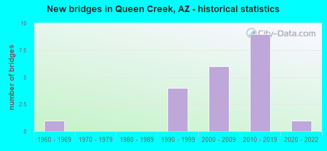
- New bridges - historical statistics
- 11960-1969
- 41990-1999
- 62000-2009
- 92010-2019
- 12020-2022

- Reconstructed bridges - Historical Statistics
- 11980-1989
- 01990-1999
- 12000-2009


- Bridge Condition - Deck
- 37.5%Very good
- 12.5%Good
- 50.0%Satisfactory

- Bridge Condition - Superstructure
- 37.5%Very good
- 12.5%Good
- 50.0%Satisfactory

- Bridge Condition - Substructure
- 50.0%Very good
- 50.0%Good

- Bridge Condition - Channel
- 60.0%Very good
- 30.0%Good
- 5.0%Satisfactory
- 5.0%Fair

- Bridge Condition - Culverts
- 58.3%Very good
- 41.7%Good
Find on map >> Show street view
Structure Number: 7818, Location: N/ Ocotillo Rd (Lat: 33.249469, Lng: -111.651789), Route carried "on" structure: City street , Year Built: 1991, Status: Open, Structure Length: 4.05m (13.29ft), Average Daily Traffic: 9,100 (year 2019), Truck Traffic: 10%, Average Future Daily Traffic: 9,110 (year 2039), Design Load: HS 20, Features Intersected: Queen Creek Wash, Facility Carried by Structure: Hawes Rd
Minimum Vertical Clearance: 7.62m (25.00ft), Kilometerpoint: 0.000, Lanes on structure: 2, Owner: Town or Township Highway Agency, Approaching Roadway Width: 14.6m (47.9ft), Skew: 2 degrees, Material/Design: Concrete continuous, Design/Construction: Slab, Number Of Spans In Main Unit: 3, Length of Maximum Span: 15.2m (49.9ft), Curb or Sidewalk Widths: Left: 0.0m, Right: 1.8m (5.9ft), Curb-To-Curb Width: 20.7m (67.9ft), Out-to-Out Width: 23.7m (77.8ft)
Condition: Deck: Satisfactory, Superstructure: Satisfactory, Substructure: Good, Channel: Good, Operating Rating: 68.9 metric tons, Method Used To Determine Operating Rating: Load Factor (LF), Inventory Rating: 40.8 metric tons, Method Used To Determine Inventory Rating: Load Factor (LF), Structural Evaluation: Equal to present minimum criteria, Deck Geometry: Superior to present desirable criteria, Waterway Adequacy: Better than present minimum criteria, Approach Roadway Alignment: Equal to present desirable criteria, Designated Inspection Frequency: Every 24 months, Inspection Date: December 2020, Deck Structure Type: Concrete Cast-file-Place, Wearing Surface/Protective System: Wearing Surface: Monolithic Concrete
Find on map >> Show street view
Structure Number: 9138, Location: Ellswth Rd at Empire Blvd (Lat: 33.205056, Lng: -111.634472), Route carried "on" structure: City street , Year Built: 1968, Year Reconstructed: 1987, Status: Open, Structure Length: 2.32m (7.61ft), Average Daily Traffic: 12,000 (year 2019), Truck Traffic: 5%, Average Future Daily Traffic: 12,010 (year 2039), Design Load: HS 20, Features Intersected: Sonoqui Wash, Facility Carried by Structure: Ellsworth Rd
Minimum Vertical Clearance: 6.10m (20.01ft), Kilometerpoint: 38.898, Lanes on structure: 5, Owner: Town or Township Highway Agency, Approaching Roadway Width: 29.3m (96.1ft), Skew: 4 degrees, Material/Design: Concrete continuous, Design/Construction: Culvert, Number Of Spans In Main Unit: 5, Length of Maximum Span: 3.0m (9.8ft), Curb or Sidewalk Widths: Left: 1.8m (5.9ft), Right: 1.8m (5.9ft)
Condition: Channel: Very good, Culverts: Very good, Operating Rating: 62.6 metric tons, Method Used To Determine Operating Rating: Load Factor (LF), Inventory Rating: 37.2 metric tons, Method Used To Determine Inventory Rating: Load Factor (LF), Structural Evaluation: Equal to present desirable criteria, Waterway Adequacy: Equal to present desirable criteria, Approach Roadway Alignment: Equal to present desirable criteria, Designated Inspection Frequency: Every 48 months, Inspection Date: November 2019
Find on map >> Show street view
Structure Number: 10045, Location: 0.5 mi S/ Ocotillo Rd (Lat: 33.240400, Lng: -111.634500), Route carried "on" structure: City street , Year Built: 1996, Status: Open, Structure Length: 4.36m (14.30ft), Average Daily Traffic: 8,400 (year 2019), Truck Traffic: 10%, Average Future Daily Traffic: 8,410 (year 2039), Design Load: HS 20, Features Intersected: Queen Creek Wash, Facility Carried by Structure: Ellsworth Road
Minimum Vertical Clearance: 30+ m (98+ ft), Kilometerpoint: 0.000, Lanes on structure: 5, Owner: Town or Township Highway Agency, Approaching Roadway Width: 14.6m (47.9ft), Skew: 4 degrees, Material/Design: Concrete continuous, Design/Construction: Slab, Number Of Spans In Main Unit: 3, Length of Maximum Span: 16.5m (54.1ft), Curb or Sidewalk Widths: Left: 2.0m (6.6ft), Right: 2.0m (6.6ft), Curb-To-Curb Width: 20.7m (67.9ft), Out-to-Out Width: 25.6m (84.0ft)
Condition: Deck: Satisfactory, Superstructure: Satisfactory, Substructure: Good, Channel: Good, Operating Rating: 70.8 metric tons, Method Used To Determine Operating Rating: Load Factor (LF), Inventory Rating: 42.6 metric tons, Method Used To Determine Inventory Rating: Load Factor (LF), Structural Evaluation: Equal to present minimum criteria, Deck Geometry: Somewhat better than minimum adequacy, Waterway Adequacy: Equal to present minimum criteria, Approach Roadway Alignment: Equal to present desirable criteria, Designated Inspection Frequency: Every 24 months, Inspection Date: December 2020, Deck Structure Type: Concrete Cast-file-Place, Wearing Surface/Protective System: Wearing Surface: Monolithic Concrete
Find on map >> Show street view
Structure Number: 10089, Location: E of Hawes Rd (Lat: 33.248711, Lng: -111.649389), Route carried "on" structure: City street , Year Built: 1997, Status: Open, Structure Length: 7.28m (23.88ft), Average Daily Traffic: 20,600 (year 2019), Truck Traffic: 10%, Average Future Daily Traffic: 20,610 (year 2039), Design Load: HS 20, Features Intersected: Queen Creek, Facility Carried by Structure: Ocotillo Road
Minimum Vertical Clearance: 30+ m (98+ ft), Kilometerpoint: 0.000, Lanes on structure: 5, Owner: Town or Township Highway Agency, Approaching Roadway Width: 20.7m (67.9ft), Skew: 6 degrees, Material/Design: Concrete continuous, Design/Construction: Slab, Number Of Spans In Main Unit: 4, Length of Maximum Span: 19.8m (65.0ft), Curb or Sidewalk Widths: Left: 1.8m (5.9ft), Right: 1.8m (5.9ft), Curb-To-Curb Width: 20.7m (67.9ft), Out-to-Out Width: 25.6m (84.0ft)
Condition: Deck: Satisfactory, Superstructure: Satisfactory, Substructure: Good, Channel: Good, Operating Rating: 36.3 metric tons, Method Used To Determine Operating Rating: Field evaluation and documented engineering judgment, Inventory Rating: 21.8 metric tons, Method Used To Determine Inventory Rating: Field evaluation and documented engineering judgment, Structural Evaluation: Somewhat better than minimum adequacy, Deck Geometry: Somewhat better than minimum adequacy, Waterway Adequacy: Better than present minimum criteria, Approach Roadway Alignment: Equal to present desirable criteria, Designated Inspection Frequency: Every 24 months, Inspection Date: December 2020, Deck Structure Type: Concrete Cast-file-Place, Wearing Surface/Protective System: Wearing Surface: Epoxy Overlay
Find on map >> Show street view
Structure Number: 10107, Location: just S/ Chandler Hts Rd (Lat: 33.236111, Lng: -111.686111), Route carried "on" structure: City street , Year Built: 1997, Status: Open, Structure Length: 0.73m (2.40ft), Average Daily Traffic: 12,200 (year 2015), Truck Traffic: 10%, Average Future Daily Traffic: 12,210 (year 2036), Design Load: HS 20, Features Intersected: Drainage Ditch, Facility Carried by Structure: Power Road
Minimum Vertical Clearance: 30+ m (98+ ft), Kilometerpoint: 0.000, Lanes on structure: 4, Owner: Town or Township Highway Agency, Approaching Roadway Width: 10.4m (34.1ft), Skew: 3 degrees, Material/Design: Concrete continuous, Design/Construction: Culvert, Number Of Spans In Main Unit: 2, Length of Maximum Span: 3.0m (9.8ft), Curb or Sidewalk Widths: Left: 2.6m (8.5ft), Right: 0.0m, Curb-To-Curb Width: 20.7m (67.9ft), Out-to-Out Width: 20.7m (67.9ft)
Condition: Channel: Satisfactory, Culverts: Good, Operating Rating: 52.6 metric tons, Method Used To Determine Operating Rating: Load Factor (LF), Inventory Rating: 31.8 metric tons, Method Used To Determine Inventory Rating: Load Factor (LF), Structural Evaluation: Better than present minimum criteria, Deck Geometry: Superior to present desirable criteria, Waterway Adequacy: Better than present minimum criteria, Approach Roadway Alignment: Equal to present desirable criteria, Designated Inspection Frequency: Every 48 months, Inspection Date: December 2020, Deck Structure Type: Concrete Cast-file-Place, Wearing Surface/Protective System: Wearing Surface: Bituminous
Find on map >> Show street view
Structure Number: 10563, Location: 0.4 mi S. of Ocotillo Rd (Lat: 33.242972, Lng: -111.637750), Route carried "on" structure: City street , Year Built: 2007, Status: Open, Structure Length: 6.35m (20.83ft), Average Daily Traffic: 8,400 (year 2019), Truck Traffic: 7%, Average Future Daily Traffic: 8,410 (year 2040), Design Load: HS 25 or greater, Features Intersected: Queen Creek Wash, Facility Carried by Structure: Ellsworth Loop Rd
Minimum Vertical Clearance: 30+ m (98+ ft), Kilometerpoint: 0.000, Lanes on structure: 3, Owner: Town or Township Highway Agency, Approaching Roadway Width: 12.8m (42.0ft), Skew: 3 degrees, Material/Design: Prestressed concrete continuous, Design/Construction: Stringer/Multi-beam, Number Of Spans In Main Unit: 2, Length of Maximum Span: 30.8m (101.0ft), Curb or Sidewalk Widths: Left: 0.0m, Right: 1.9m (6.2ft), Curb-To-Curb Width: 13.4m (44.0ft), Out-to-Out Width: 16.2m (53.1ft)
Condition: Deck: Very good, Superstructure: Very good, Substructure: Very good, Channel: Very good, Operating Rating: 89.8 metric tons, Method Used To Determine Operating Rating: Load Factor (LF), Inventory Rating: 39.0 metric tons, Method Used To Determine Inventory Rating: Load Factor (LF), Structural Evaluation: Equal to present desirable criteria, Deck Geometry: Somewhat better than minimum adequacy, Waterway Adequacy: Equal to present desirable criteria, Approach Roadway Alignment: Equal to present desirable criteria, Designated Inspection Frequency: Every 24 months, Inspection Date: December 2020, Deck Structure Type: Concrete Cast-file-Place, Wearing Surface/Protective System: Wearing Surface: Monolithic Concrete
Find on map >> Show street view
Structure Number: 10564, Location: 0.4 mi S. of Ocotillo Rd. (Lat: 33.242972, Lng: -111.637750), Route carried "on" structure: City street , Year Built: 2007, Status: Open, Structure Length: 6.35m (20.83ft), Average Daily Traffic: 40,100 (year 2019), Truck Traffic: 10%, Average Future Daily Traffic: 40,110 (year 2040), Design Load: HS 25 or greater, Features Intersected: Queen Creek Wash, Facility Carried by Structure: Ellsworth Loop Rd
Minimum Vertical Clearance: 30+ m (98+ ft), Kilometerpoint: 0.000, Lanes on structure: 3, Owner: Town or Township Highway Agency, Approaching Roadway Width: 12.8m (42.0ft), Skew: 3 degrees, Material/Design: Prestressed concrete continuous, Design/Construction: Stringer/Multi-beam, Number Of Spans In Main Unit: 2, Length of Maximum Span: 30.8m (101.0ft), Curb or Sidewalk Widths: Left: 1.9m (6.2ft), Right: 0.0m, Curb-To-Curb Width: 13.4m (44.0ft), Out-to-Out Width: 16.2m (53.1ft)
Condition: Deck: Very good, Superstructure: Very good, Substructure: Very good, Channel: Very good, Operating Rating: 89.8 metric tons, Method Used To Determine Operating Rating: Load Factor (LF), Inventory Rating: 39.0 metric tons, Method Used To Determine Inventory Rating: Load Factor (LF), Structural Evaluation: Equal to present desirable criteria, Deck Geometry: Somewhat better than minimum adequacy, Waterway Adequacy: Equal to present desirable criteria, Approach Roadway Alignment: Equal to present desirable criteria, Designated Inspection Frequency: Every 24 months, Inspection Date: December 2020, Deck Structure Type: Concrete Cast-file-Place, Wearing Surface/Protective System: Wearing Surface: Monolithic Concrete
Find on map >> Show street view
Structure Number: 10588, Location: 10.6 mi S Jct US 60 (Lat: 33.241667, Lng: -111.572222), Route carried "on" structure: County highway , Year Built: 2004, Status: Open, Structure Length: 1.34m (4.40ft), Average Daily Traffic: 14,182 (year 2020), Truck Traffic: 5%, Average Future Daily Traffic: 14,192 (year 2040), Design Load: HS 20, Features Intersected: Queen Creek, Facility Carried by Structure: Gantzel Rd
Minimum Vertical Clearance: 30+ m (98+ ft), Kilometerpoint: 0.000, Lanes on structure: 4, Owner: County Highway Agency, Approaching Roadway Width: 15.5m (50.9ft), Material/Design: Concrete continuous, Design/Construction: Culvert, Number Of Spans In Main Unit: 5, Length of Maximum Span: 2.4m (7.9ft)
Condition: Channel: Fair, Culverts: Good, Operating Rating: 74.4 metric tons, Method Used To Determine Operating Rating: Load Factor (LF), Inventory Rating: 44.5 metric tons, Method Used To Determine Inventory Rating: Load Factor (LF), Structural Evaluation: Better than present minimum criteria, Waterway Adequacy: Equal to present desirable criteria, Approach Roadway Alignment: Equal to present desirable criteria, Designated Inspection Frequency: Every 48 months, Inspection Date: October 2021
Find on map >> Show street view
Structure Number: 10631, Location: 100' So of Queen Crk (Lat: 33.262775, Lng: -111.669197), Route carried "on" structure: City street , Year Built: 2006, Status: Open, Structure Length: 4.30m (14.11ft), Average Daily Traffic: 7,500 (year 2020), Truck Traffic: 10%, Average Future Daily Traffic: 7,510 (year 2040), Design Load: HS 20, Features Intersected: Queen Creek Wash, Facility Carried by Structure: Sossaman Road
Minimum Vertical Clearance: 30+ m (98+ ft), Kilometerpoint: 0.000, Lanes on structure: 4, Owner: Town or Township Highway Agency, Approaching Roadway Width: 22.6m (74.1ft), Skew: 23 degrees, Material/Design: Concrete continuous, Design/Construction: Slab, Number Of Spans In Main Unit: 3, Length of Maximum Span: 14.6m (47.9ft), Curb or Sidewalk Widths: Left: 2.0m (6.6ft), Right: 2.0m (6.6ft), Curb-To-Curb Width: 22.6m (74.1ft), Out-to-Out Width: 27.3m (89.6ft)
Condition: Deck: Satisfactory, Superstructure: Satisfactory, Substructure: Good, Channel: Good, Operating Rating: 89.8 metric tons, Method Used To Determine Operating Rating: Load Factor (LF), Inventory Rating: 55.3 metric tons, Method Used To Determine Inventory Rating: Load Factor (LF), Structural Evaluation: Equal to present minimum criteria, Deck Geometry: Superior to present desirable criteria, Waterway Adequacy: Equal to present desirable criteria, Approach Roadway Alignment: Equal to present desirable criteria, Designated Inspection Frequency: Every 24 months, Inspection Date: December 2020, Deck Structure Type: Concrete Cast-file-Place, Wearing Surface/Protective System: Wearing Surface: Monolithic Concrete
Find on map >> Show street view
Structure Number: 10777, Location: 0.4 mi. E/ of Sossaman R (Lat: 33.234083, Lng: -111.664083), Route carried "on" structure: City street , Year Built: 2008, Status: Open, Structure Length: 5.68m (18.64ft), Average Daily Traffic: 7,300 (year 2019), Truck Traffic: 10%, Average Future Daily Traffic: 7,310 (year 2040), Design Load: HL 93, Features Intersected: Sonoqui Wash, Facility Carried by Structure: Chandler Hghts Rd
Minimum Vertical Clearance: 30+ m (98+ ft), Kilometerpoint: 0.000, Lanes on structure: 2, Owner: Town or Township Highway Agency, Approaching Roadway Width: 10.4m (34.1ft), Skew: 3 degrees, Material/Design: Prestressed concrete continuous, Design/Construction: Box Beam or Girders - Single/Spread, Number Of Spans In Main Unit: 3, Length of Maximum Span: 20.7m (67.9ft), Curb or Sidewalk Widths: Left: 2.2m (7.2ft), Right: 2.2m (7.2ft), Curb-To-Curb Width: 21.9m (71.9ft), Out-to-Out Width: 27.1m (88.9ft)
Condition: Deck: Very good, Superstructure: Good, Substructure: Very good, Channel: Very good, Operating Rating: 84.4 metric tons, Method Used To Determine Operating Rating: Load Factor (LF), Inventory Rating: 50.8 metric tons, Method Used To Determine Inventory Rating: Load Factor (LF), Structural Evaluation: Better than present minimum criteria, Deck Geometry: Superior to present desirable criteria, Waterway Adequacy: Equal to present desirable criteria, Approach Roadway Alignment: Equal to present desirable criteria, Designated Inspection Frequency: Every 24 months, Inspection Date: December 2020, Deck Structure Type: Concrete Cast-file-Place, Wearing Surface/Protective System: Wearing Surface: Monolithic Concrete
Find on map >> Show street view
Structure Number: 11107, Location: 100 ft S Riggs Rd (Lat: 33.219167, Lng: -111.634444), Route carried "on" structure: City street , Year Built: 2011, Year Reconstructed: 2012, Status: Open, Structure Length: 1.65m (5.41ft), Average Daily Traffic: 12,000 (year 2019), Truck Traffic: 5%, Average Future Daily Traffic: 12,010 (year 2039), Design Load: HS 20, Features Intersected: Sonoqui Wash East Branch, Facility Carried by Structure: Ellsworth Rd
Minimum Vertical Clearance: 30+ m (98+ ft), Kilometerpoint: 0.000, Lanes on structure: 9, Owner: Town or Township Highway Agency, Approaching Roadway Width: 36.6m (120.1ft), Material/Design: Concrete continuous, Design/Construction: Culvert, Number Of Spans In Main Unit: 6, Length of Maximum Span: 3.0m (9.8ft), Curb or Sidewalk Widths: Left: 1.8m (5.9ft), Right: 1.8m (5.9ft)
Condition: Channel: Very good, Culverts: Good, Operating Rating: 50.8 metric tons, Method Used To Determine Operating Rating: Load Factor (LF), Inventory Rating: 29.9 metric tons, Method Used To Determine Inventory Rating: Load Factor (LF), Structural Evaluation: Better than present minimum criteria, Waterway Adequacy: Equal to present desirable criteria, Approach Roadway Alignment: Equal to present desirable criteria, Designated Inspection Frequency: Every 48 months, Inspection Date: November 2019
Find on map >> Show street view
Structure Number: 11108, Location: 0.2 mi E of Hawes Rd (Lat: 33.219600, Lng: -111.648400), Route carried "on" structure: City street , Year Built: 2012, Status: Open, Structure Length: 5.82m (19.09ft), Average Daily Traffic: 7,098 (year 2018), Truck Traffic: 5%, Average Future Daily Traffic: 7,108 (year 2038), Design Load: HS 20, Features Intersected: Sonoqui Wash, Facility Carried by Structure: Riggs Rd
Minimum Vertical Clearance: 30+ m (98+ ft), Kilometerpoint: 0.000, Lanes on structure: 4, Owner: County Highway Agency, Approaching Roadway Width: 12.8m (42.0ft), Skew: 3 degrees, Material/Design: Prestressed concrete continuous, Design/Construction: Stringer/Multi-beam, Number Of Spans In Main Unit: 2, Length of Maximum Span: 28.0m (91.9ft), Curb or Sidewalk Widths: Left: 1.8m (5.9ft), Right: 1.8m (5.9ft), Curb-To-Curb Width: 21.9m (71.9ft), Out-to-Out Width: 26.4m (86.6ft)
Condition: Deck: Good, Superstructure: Very good, Substructure: Very good, Channel: Very good, Operating Rating: 90.5 metric tons, Method Used To Determine Operating Rating: Load Factor (LF), Inventory Rating: 38.7 metric tons, Method Used To Determine Inventory Rating: Load Factor (LF), Structural Evaluation: Equal to present desirable criteria, Deck Geometry: Superior to present desirable criteria, Waterway Adequacy: Equal to present desirable criteria, Approach Roadway Alignment: Equal to present desirable criteria, Designated Inspection Frequency: Every 24 months, Inspection Date: December 2021, Deck Structure Type: Concrete Cast-file-Place, Wearing Surface/Protective System: Wearing Surface: Monolithic Concrete
Find on map >> Show street view
Structure Number: 11109, Location: South of Riggs Rd (Lat: 33.219081, Lng: -111.644172), Route carried "on" structure: County highway , Year Built: 2011, Status: Open, Structure Length: 1.98m (6.50ft), Average Daily Traffic: 200 (year 2020), Average Future Daily Traffic: 210 (year 2040), Design Load: HS 20, Features Intersected: Sonoqui Wash, Facility Carried by Structure: 203rd Place
Minimum Vertical Clearance: 30+ m (98+ ft), Kilometerpoint: 0.000, Lanes on structure: 2, Owner: County Highway Agency, Approaching Roadway Width: 9.8m (32.2ft), Material/Design: Concrete continuous, Design/Construction: Culvert, Number Of Spans In Main Unit: 6, Length of Maximum Span: 3.0m (9.8ft), Curb or Sidewalk Widths: Left: 1.5m (4.9ft), Right: 1.5m (4.9ft)
Condition: Channel: Very good, Culverts: Good, Inventory Rating: 61.2 metric tons, Method Used To Determine Inventory Rating: Load Factor (LF), Structural Evaluation: Better than present minimum criteria, Waterway Adequacy: Equal to present desirable criteria, Approach Roadway Alignment: Equal to present minimum criteria, Designated Inspection Frequency: Every 48 months, Inspection Date: January 2020
Find on map >> Show street view
Structure Number: 1111, Location: 0.2 mi W/ 203rd Place (Lat: 33.218803, Lng: -111.647733), Route carried "on" structure: County highway , Year Built: 2011, Status: Open, Structure Length: 0.98m (3.22ft), Average Daily Traffic: 100 (year 2020), Average Future Daily Traffic: 110 (year 2020), Design Load: HS 20, Features Intersected: Drainage Ditch, Facility Carried by Structure: Marsh Rd
Minimum Vertical Clearance: 30+ m (98+ ft), Kilometerpoint: 0.000, Lanes on structure: 2, Owner: County Highway Agency, Approaching Roadway Width: 9.1m (29.9ft), Material/Design: Concrete continuous, Design/Construction: Culvert, Number Of Spans In Main Unit: 3, Length of Maximum Span: 3.0m (9.8ft), Curb or Sidewalk Widths: Left: 0.0m, Right: 1.5m (4.9ft)
Condition: Channel: Very good, Culverts: Good, Inventory Rating: 91.9 metric tons, Method Used To Determine Inventory Rating: Load Factor (LF), Structural Evaluation: Better than present minimum criteria, Waterway Adequacy: Equal to present desirable criteria, Approach Roadway Alignment: Equal to present minimum criteria, Designated Inspection Frequency: Every 48 months, Inspection Date: January 2020
Find on map >> Show street view
Structure Number: 11492, Location: 1.0 mi W Jct Thompson Rd (Lat: 33.201100, Lng: -111.630100), Route carried "on" structure: County highway , Year Built: 2014, Status: Open, Structure Length: 1.65m (5.41ft), Average Daily Traffic: 22,584 (year 2019), Truck Traffic: 5%, Average Future Daily Traffic: 22,594 (year 2039), Design Load: HS 20, Features Intersected: Channel, Facility Carried by Structure: Hunt Hwy
Minimum Vertical Clearance: 30+ m (98+ ft), Kilometerpoint: 0.000, Lanes on structure: 4, Owner: County Highway Agency, Approaching Roadway Width: 21.3m (69.9ft), Skew: 1 degrees, Material/Design: Concrete continuous, Design/Construction: Culvert, Number Of Spans In Main Unit: 5, Length of Maximum Span: 3.0m (9.8ft), Curb or Sidewalk Widths: Left: 1.2m (3.9ft), Right: 0.0m
Condition: Channel: Very good, Culverts: Very good, Operating Rating: 89.8 metric tons, Method Used To Determine Operating Rating: Load Factor (LF), Inventory Rating: 89.8 metric tons, Method Used To Determine Inventory Rating: Load Factor (LF), Structural Evaluation: Equal to present desirable criteria, Waterway Adequacy: Equal to present desirable criteria, Approach Roadway Alignment: Equal to present desirable criteria, Designated Inspection Frequency: Every 48 months, Inspection Date: November 2019
Find on map >> Show street view
Structure Number: 11493, Location: 0.8 mi W Jct Thompson Rd (Lat: 33.200608, Lng: -111.625686), Route carried "on" structure: County highway , Year Built: 2014, Status: Open, Structure Length: 0.91m (2.99ft), Average Daily Traffic: 22,584 (year 2019), Truck Traffic: 5%, Average Future Daily Traffic: 22,594 (year 2039), Design Load: HS 20, Features Intersected: Channel, Facility Carried by Structure: Hunt Hwy
Minimum Vertical Clearance: 30+ m (98+ ft), Kilometerpoint: 0.000, Lanes on structure: 4, Owner: County Highway Agency, Approaching Roadway Width: 21.3m (69.9ft), Skew: 4 degrees, Material/Design: Concrete continuous, Design/Construction: Culvert, Number Of Spans In Main Unit: 2, Length of Maximum Span: 3.0m (9.8ft), Curb or Sidewalk Widths: Left: 1.2m (3.9ft), Right: 0.0m
Condition: Channel: Very good, Culverts: Very good, Operating Rating: 89.8 metric tons, Method Used To Determine Operating Rating: Load Factor (LF), Inventory Rating: 78.0 metric tons, Method Used To Determine Inventory Rating: Load Factor (LF), Structural Evaluation: Equal to present desirable criteria, Waterway Adequacy: Equal to present desirable criteria, Approach Roadway Alignment: Equal to present desirable criteria, Designated Inspection Frequency: Every 48 months, Inspection Date: November 2019
Find on map >> Show street view
Structure Number: 11494, Location: 150 ft W Jct Thompson Rd (Lat: 33.198750, Lng: -111.613350), Route carried "on" structure: County highway , Year Built: 2014, Status: Open, Structure Length: 0.98m (3.22ft), Average Daily Traffic: 22,584 (year 2019), Truck Traffic: 5%, Average Future Daily Traffic: 22,594 (year 2039), Design Load: HS 20, Features Intersected: Channel, Facility Carried by Structure: Hunt Hwy
Minimum Vertical Clearance: 30+ m (98+ ft), Kilometerpoint: 0.000, Lanes on structure: 6, Owner: County Highway Agency, Approaching Roadway Width: 28.0m (91.9ft), Material/Design: Concrete, Design/Construction: Culvert, Number Of Spans In Main Unit: 3, Length of Maximum Span: 3.0m (9.8ft)
Condition: Channel: Good, Culverts: Very good, Operating Rating: 89.8 metric tons, Method Used To Determine Operating Rating: Load Factor (LF), Inventory Rating: 89.8 metric tons, Method Used To Determine Inventory Rating: Load Factor (LF), Structural Evaluation: Equal to present desirable criteria, Waterway Adequacy: Equal to present desirable criteria, Approach Roadway Alignment: Equal to present desirable criteria, Designated Inspection Frequency: Every 48 months, Inspection Date: November 2019
Find on map >> Show street view
Structure Number: 11527, Location: 0.04 mi N of Barnes Pkwy (Lat: 33.259744, Lng: -111.573586), Route carried "on" structure: County highway , Year Built: 2015, Status: Open, Structure Length: 1.04m (3.41ft), Average Daily Traffic: 500 (year 2019), Truck Traffic: 1%, Average Future Daily Traffic: 510 (year 2039), Design Load: HS 20, Features Intersected: Wesbrooke Drnge Channel, Facility Carried by Structure: Euell Dr
Minimum Vertical Clearance: 30+ m (98+ ft), Kilometerpoint: 0.000, Lanes on structure: 2, Owner: County Highway Agency, Approaching Roadway Width: 23.5m (77.1ft), Skew: 2 degrees, Material/Design: Concrete continuous, Design/Construction: Culvert, Number Of Spans In Main Unit: 3, Length of Maximum Span: 3.4m (11.2ft), Curb or Sidewalk Widths: Left: 1.5m (4.9ft), Right: 1.5m (4.9ft), Curb-To-Curb Width: 14.6m (47.9ft), Out-to-Out Width: 23.4m (76.8ft)
Condition: Channel: Good, Culverts: Very good, Operating Rating: 65.3 metric tons, Method Used To Determine Operating Rating: Load Factor (LF), Inventory Rating: 39.0 metric tons, Method Used To Determine Inventory Rating: Load Factor (LF), Structural Evaluation: Equal to present desirable criteria, Deck Geometry: Superior to present desirable criteria, Waterway Adequacy: Equal to present desirable criteria, Approach Roadway Alignment: Equal to present desirable criteria, Designated Inspection Frequency: Every 48 months, Inspection Date: November 2019
Find on map >> Show street view
Structure Number: 11578, Location: 0.25 mi W of Hawes Rd (Lat: 33.219500, Lng: -111.655900), Route carried "on" structure: County highway , Year Built: 2019, Status: Open, Structure Length: 0.64m (2.10ft), Average Daily Traffic: 7,098 (year 2018), Truck Traffic: 5%, Average Future Daily Traffic: 8,008 (year 2038), Design Load: HS 20, Features Intersected: Wash, Facility Carried by Structure: Riggs Road
Minimum Vertical Clearance: 30+ m (98+ ft), Kilometerpoint: 0.000, Lanes on structure: 4, Owner: County Highway Agency, Approaching Roadway Width: 24.4m (80.1ft), Material/Design: Concrete continuous, Design/Construction: Culvert, Number Of Spans In Main Unit: 2, Length of Maximum Span: 3.0m (9.8ft)
Condition: Channel: Very good, Culverts: Very good, Operating Rating: 94.3 metric tons, Method Used To Determine Operating Rating: Load Factor (LF), Inventory Rating: 56.5 metric tons, Method Used To Determine Inventory Rating: Load Factor (LF), Structural Evaluation: Equal to present desirable criteria, Waterway Adequacy: Equal to present desirable criteria, Approach Roadway Alignment: Equal to present desirable criteria, Designated Inspection Frequency: Every 48 months, Inspection Date: January 2020
Find on map >> Show street view
Structure Number: 11695, Location: 0.25 mi NW of Cloud Rd (Lat: 33.230100, Lng: -111.594100), Route carried "on" structure: City street , Year Built: 2021, Status: Open, Structure Length: 4.24m (13.91ft), Average Daily Traffic: 20,398 (year 2021), Truck Traffic: 10%, Average Future Daily Traffic: 20,408 (year 2041), Design Load: HL 93, Features Intersected: Queen Creek Wash, Facility Carried by Structure: Rittenhouse Rd
Minimum Vertical Clearance: 30+ m (98+ ft), Kilometerpoint: 0.000, Lanes on structure: 4, Owner: Town or Township Highway Agency, Approaching Roadway Width: 24.1m (79.1ft), Skew: 20 degrees, Material/Design: Concrete, Design/Construction: Culvert, Number Of Spans In Main Unit: 11, Length of Maximum Span: 3.7m (12.1ft), Curb or Sidewalk Widths: Left: 1.7m (5.6ft), Right: 1.7m (5.6ft), Curb-To-Curb Width: 20.7m (67.9ft), Out-to-Out Width: 24.1m (79.1ft)
Condition: Channel: Very good, Culverts: Very good, Operating Rating: 32.7 metric tons, Method Used To Determine Operating Rating: No rating analysis performed, Inventory Rating: 32.7 metric tons, Method Used To Determine Inventory Rating: No rating analysis performed, Structural Evaluation: Equal to present desirable criteria, Deck Geometry: Superior to present desirable criteria, Waterway Adequacy: Equal to present desirable criteria, Approach Roadway Alignment: Equal to present desirable criteria, Designated Inspection Frequency: Every 48 months, Inspection Date: December 2021, Deck Structure Type: Concrete Cast-file-Place, Wearing Surface/Protective System: Wearing Surface: Monolithic Concrete
Find on map >> Show street view
Structure Number: 10583, Location: 200 ft N Jct Rittenhous (Lat: 33.258583, Lng: -111.638028), Route carried "under" structure: City street , Year Built: 2007, Structure Length: 0. m, Average Daily Traffic: 45,800 (year 2019), Truck Traffic: 10%, Features Intersected: Ellsworth Loop Rd, Facility Carried by Structure: UPRR
Minimum Vertical Clearance: 5.64m (18.50ft), Kilometerpoint: 0.000, Material/Design: Steel, Design/Construction: Stringer/Multi-beam, Length of Maximum Span: 25.0m (82.0ft)