Bridge Statistics for Punta Gorda, Florida (FL)
Condition, Traffic, Stress, Structural Evaluation, Project Costs
- National Bridge Inventory (NBI) Statistics
- 25Number of bridges
- 1,033ft / 315mTotal length
- $2,249,000Total costs
- 462,709Total average daily traffic
- 57,855Total average daily truck traffic
- National Bridge Inventory (NBI) Registered Bridges for Punta Gorda
- No street view available for this location
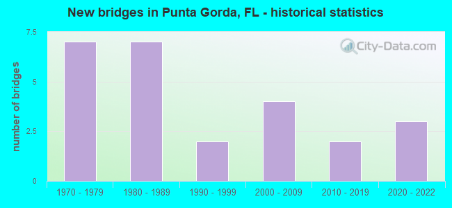
- New bridges - historical statistics
- 71970-1979
- 71980-1989
- 21990-1999
- 42000-2009
- 22010-2019
- 32020-2022

- Reconstructed bridges - Historical Statistics
- 11990-1999
- 22000-2009
- 22010-2019


- Bridge Condition - Deck
- 8.3%Excellent
- 66.7%Good
- 25.0%Satisfactory

- Bridge Condition - Superstructure
- 8.3%Excellent
- 75.0%Good
- 16.7%Satisfactory

- Bridge Condition - Substructure
- 8.3%Excellent
- 83.3%Good
- 8.3%Satisfactory

- Bridge Condition - Channel
- 16.7%Excellent
- 8.3%Very good
- 58.3%Good
- 16.7%Satisfactory

- Bridge Condition - Culverts
- 25.0%Very good
- 75.0%Good
Find on map >> Show street view
Structure Number: 10052, Location: 0.8 MI. WEST OF US-41 (Lat: 26.902528, Lng: -82.050042), Route carried "on" structure: County highway , Year Built: 1973, Status: Posted for load, Structure Length: 2.38m (7.81ft), Average Daily Traffic: 2,180 (year 2021), Truck Traffic: 2%, Average Future Daily Traffic: 3,783 (year 2042), Design Load: H 20, Features Intersected: VENICE CANAL, Facility Carried by Structure: RIO VILLA DRIVE
Minimum Vertical Clearance: 30+ m (98+ ft), Kilometerpoint: 0.000, Lanes on structure: 2, Owner: County Highway Agency, Approaching Roadway Width: 6.2m (20.3ft), Material/Design: Concrete continuous, Design/Construction: Slab, Number Of Spans In Main Unit: 3, Length of Maximum Span: 9.0m (29.5ft), Curb-To-Curb Width: 8.3m (27.2ft), Out-to-Out Width: 8.9m (29.2ft)
Condition: Deck: Satisfactory, Superstructure: Satisfactory, Substructure: Good, Channel: Very good, Operating Rating: 41.7 metric tons, Method Used To Determine Operating Rating: Load Factor (LF), Inventory Rating: 25.0 metric tons, Method Used To Determine Inventory Rating: Load Factor (LF), Structural Evaluation: Equal to present minimum criteria, Deck Geometry: High priority of corrective action, Waterway Adequacy: Better than present minimum criteria, Approach Roadway Alignment: Equal to present minimum criteria, Bridge Posting: Required (Relationship of Operating Rating to Maximum Legal Load: 0.1 - 9.9% below), Designated Inspection Frequency: Every 24 months, Underwater Inspection Frequency: Every 24 months, Other Special Inspection Frequency: Every 12 months, Inspection Date: May 2021, Underwater Inspection Date: April 2021, Other Special Inspection Date: May 2021, Deck Structure Type: Concrete Cast-file-Place
Find on map >> Show street view
Structure Number: 10069, Location: 3.7 MI S OF US-17 (Lat: 26.890944, Lng: -81.998083), Route carried "on" structure: Interstate 75, Year Built: 1981, Year Reconstructed: 2012, Status: Open, Structure Length: 10.66m (34.97ft), Average Daily Traffic: 27,000 (year 2020), Truck Traffic: 14%, Average Future Daily Traffic: 46,845 (year 2042), Design Load: HL 93, Features Intersected: ALLIGATOR CREEK
Minimum Vertical Clearance: 30+ m (98+ ft), Kilometerpoint: 18.274, Lanes on structure: 4, Base Highway Network: Yes, Owner: State Highway Agency, Approaching Roadway Width: 19.5m (64.0ft), Material/Design: Steel continuous, Design/Construction: Stringer/Multi-beam, Number Of Spans In Main Unit: 3, Length of Maximum Span: 42.0m (137.8ft), Curb-To-Curb Width: 19.5m (64.0ft), Out-to-Out Width: 20.5m (67.3ft)
Condition: Deck: Good, Superstructure: Good, Substructure: Good, Channel: Good, Operating Rating: 47.7 metric tons, Method Used To Determine Operating Rating: Load and Resistance Factor (LRFR), Inventory Rating: 36.6 metric tons, Method Used To Determine Inventory Rating: Load and Resistance Factor (LRFR), Structural Evaluation: Better than present minimum criteria, Deck Geometry: Somewhat better than minimum adequacy, Waterway Adequacy: Equal to present desirable criteria, Approach Roadway Alignment: Equal to present desirable criteria, Length Of Structure Improvement: 10.67m (35.01ft), Designated Inspection Frequency: Every 24 months, Inspection Date: June 2021, Bridge Improvement Cost: $685,000, Roadway Improvement Cost: $69,000, Total Project Cost: $754,000, Deck Structure Type: Concrete Cast-file-Place
Find on map >> Show street view
Structure Number: 10074, Location: 3.4MI SOUTH OF US-17 (Lat: 26.895086, Lng: -82.002067), Route carried "on" structure: Interstate 75, Year Built: 1981, Year Reconstructed: 2018, Status: Open, Structure Length: 7.24m (23.75ft), Average Daily Traffic: 27,000 (year 2020), Truck Traffic: 14%, Average Future Daily Traffic: 46,845 (year 2042), Design Load: HS 20, Features Intersected: N JONES LOOP ROAD
Minimum Vertical Clearance: 30+ m (98+ ft), Kilometerpoint: 18.929, Lanes on structure: 3, Lanes under structure: 4, Base Highway Network: Yes, Owner: State Highway Agency, Approaching Roadway Width: 16.9m (55.4ft), Skew: 4 degrees, Material/Design: Steel, Design/Construction: Stringer/Multi-beam, Number Of Spans In Main Unit: 3, Length of Maximum Span: 41.5m (136.2ft), Curb-To-Curb Width: 16.9m (55.4ft), Out-to-Out Width: 17.9m (58.7ft)
Condition: Deck: Good, Superstructure: Good, Substructure: Good, Operating Rating: 65.3 metric tons, Method Used To Determine Operating Rating: Load and Resistance Factor (LRFR), Inventory Rating: 49.4 metric tons, Method Used To Determine Inventory Rating: Load and Resistance Factor (LRFR), Structural Evaluation: Better than present minimum criteria, Deck Geometry: Equal to present minimum criteria, Underclear: Equal to present minimum criteria, Approach Roadway Alignment: Equal to present desirable criteria, Length Of Structure Improvement: 7.25m (23.79ft), Designated Inspection Frequency: Every 24 months, Inspection Date: April 2021, Bridge Improvement Cost: $700,000, Roadway Improvement Cost: $70,000, Total Project Cost: $770,000, Deck Structure Type: Concrete Cast-file-Place
Find on map >> Show street view
Structure Number: 10081, Location: 0.1MI NORTH OF US-17 (Lat: 26.942722, Lng: -82.019528), Route carried "on" structure: Interstate 75, Year Built: 1975, Year Reconstructed: 2018, Status: Open, Structure Length: 6.52m (21.39ft), Average Daily Traffic: 33,500 (year 2020), Truck Traffic: 14%, Average Future Daily Traffic: 58,122 (year 2042), Design Load: HS 20, Features Intersected: RIVERSIDE DR & CSX RR
Minimum Vertical Clearance: 30+ m (98+ ft), Kilometerpoint: 24.514, Lanes on structure: 4, Lanes under structure: 2, Base Highway Network: Yes, Owner: State Highway Agency, Approaching Roadway Width: 21.3m (69.9ft), Skew: 1 degrees, Material/Design: Prestressed concrete, Design/Construction: Stringer/Multi-beam, Number Of Spans In Main Unit: 3, Length of Maximum Span: 24.7m (81.0ft), Curb-To-Curb Width: 21.3m (69.9ft), Out-to-Out Width: 22.2m (72.8ft)
Condition: Deck: Good, Superstructure: Good, Substructure: Good, Operating Rating: 55.2 metric tons, Method Used To Determine Operating Rating: Load Factor (LF), Inventory Rating: 33.0 metric tons, Method Used To Determine Inventory Rating: Load Factor (LF), Structural Evaluation: Better than present minimum criteria, Deck Geometry: Better than present minimum criteria, Underclear: Superior to present desirable criteria, Approach Roadway Alignment: Equal to present desirable criteria, Designated Inspection Frequency: Every 24 months, Inspection Date: April 2021, Deck Structure Type: Concrete Cast-file-Place
Find on map >> Show street view
Structure Number: 10083, Location: 3.3 MI SOUTH OF CR-768 (Lat: 26.858111, Lng: -81.971000), Route carried "on" structure: Interstate 75, Year Built: 1979, Year Reconstructed: 2012, Status: Open, Structure Length: 7.50m (24.61ft), Average Daily Traffic: 24,250 (year 2020), Truck Traffic: 18%, Average Future Daily Traffic: 42,074 (year 2042), Design Load: HL 93, Features Intersected: TUCKER GRADE
Minimum Vertical Clearance: 30+ m (98+ ft), Kilometerpoint: 13.652, Lanes on structure: 3, Lanes under structure: 5, Base Highway Network: Yes, Owner: State Highway Agency, Approaching Roadway Width: 16.4m (53.8ft), Skew: 1 degrees, Material/Design: Steel, Design/Construction: Stringer/Multi-beam, Number Of Spans In Main Unit: 3, Length of Maximum Span: 47.2m (154.9ft), Curb-To-Curb Width: 17.0m (55.8ft), Out-to-Out Width: 18.0m (59.1ft)
Condition: Deck: Good, Superstructure: Good, Substructure: Good, Operating Rating: 46.1 metric tons, Method Used To Determine Operating Rating: Load and Resistance Factor (LRFR), Inventory Rating: 35.6 metric tons, Method Used To Determine Inventory Rating: Load and Resistance Factor (LRFR), Structural Evaluation: Better than present minimum criteria, Deck Geometry: Equal to present minimum criteria, Underclear: Better than present minimum criteria, Approach Roadway Alignment: Equal to present desirable criteria, Length Of Structure Improvement: 7.50m (24.61ft), Designated Inspection Frequency: Every 24 months, Inspection Date: April 2021, Bridge Improvement Cost: $659,000, Roadway Improvement Cost: $66,000, Total Project Cost: $725,000, Deck Structure Type: Concrete Cast-file-Place
Find on map >> Show street view
Structure Number: 10088, Location: 1.5 mi. S of KINGS HWY (Lat: 27.002667, Lng: -82.037547), Route carried "on" structure: County highway , Year Built: 1980, Status: Open, Structure Length: 14.26m (46.78ft), Average Daily Traffic: 12,400 (year 2020), Truck Traffic: 11%, Average Future Daily Traffic: 21,514 (year 2042), Design Load: HS 20, Features Intersected: I-75, Facility Carried by Structure: RAMPART BLVD.
Minimum Vertical Clearance: 30+ m (98+ ft), Kilometerpoint: 1.727, Lanes on structure: 2, Lanes under structure: 6, Owner: State Highway Agency, Approaching Roadway Width: 12.2m (40.0ft), Skew: 2 degrees, Material/Design: Prestressed concrete, Design/Construction: Stringer/Multi-beam, Number Of Spans In Main Unit: 6, Length of Maximum Span: 32.0m (105.0ft), Curb-To-Curb Width: 12.2m (40.0ft), Out-to-Out Width: 13.0m (42.7ft)
Condition: Deck: Satisfactory, Superstructure: Good, Substructure: Good, Operating Rating: 46.1 metric tons, Method Used To Determine Operating Rating: Load Factor (LF), Inventory Rating: 27.4 metric tons, Method Used To Determine Inventory Rating: Load Factor (LF), Structural Evaluation: Equal to present minimum criteria, Deck Geometry: Somewhat better than minimum adequacy, Underclear: Somewhat better than minimum adequacy, Approach Roadway Alignment: Equal to present desirable criteria, Designated Inspection Frequency: Every 24 months, Inspection Date: April 2021, Deck Structure Type: Concrete Precast Panels
Find on map >> Show street view
Structure Number: 10105, Location: 4.9MI WEST OF CR-771 (Lat: 26.934639, Lng: -82.302992), Route carried "on" structure: State highway 776, Year Built: 2000, Status: Open, Structure Length: 1.14m (3.74ft), Average Daily Traffic: 30,500 (year 2020), Truck Traffic: 8%, Average Future Daily Traffic: 52,918 (year 2042), Design Load: HS 20+Mod, Features Intersected: OYSTER CREEK
Minimum Vertical Clearance: 30+ m (98+ ft), Kilometerpoint: 7.092, Lanes on structure: 4, Owner: State Highway Agency, Approaching Roadway Width: 17.7m (58.1ft), Skew: 13 degrees, Material/Design: Concrete, Design/Construction: Culvert, Number Of Spans In Main Unit: 3, Length of Maximum Span: 3.7m (12.1ft), Curb or Sidewalk Widths: Left: 2.3m (7.5ft), Right: 2.2m (7.2ft)
Condition: Channel: Satisfactory, Culverts: Good, Inventory Rating: 58.8 metric tons, Method Used To Determine Inventory Rating: Load Factor (LF), Structural Evaluation: Better than present minimum criteria, Waterway Adequacy: Equal to present desirable criteria, Approach Roadway Alignment: Equal to present desirable criteria, Designated Inspection Frequency: Every 24 months, Underwater Inspection Frequency: Every 24 months, Inspection Date: June 2020, Underwater Inspection Date: May 2020
Find on map >> Show street view
Structure Number: 10106, Location: 0.75 MI N OF US17 (Lat: 26.959847, Lng: -82.020308), Route carried "on" structure: Interstate 75, Year Built: 2003, Status: Open, Structure Length: 245.16m (804.33ft), Average Daily Traffic: 67,000 (year 2020), Truck Traffic: 14%, Average Future Daily Traffic: 116,245 (year 2042), Design Load: HS 20+Mod, Features Intersected: PEACE RIVER
Minimum Vertical Clearance: 30+ m (98+ ft), Kilometerpoint: 25.331, Lanes on structure: 6, Base Highway Network: Yes, Owner: State Highway Agency, Approaching Roadway Width: 33.2m (108.9ft), Skew: 30 degrees, Navigation Control: Yes ( Vertical Clearance: 13.7m (44.9ft), Horizontal Clearance: 22.9m (75.1ft)), Material/Design: Prestressed concrete, Design/Construction: Stringer/Multi-beam, Number Of Spans In Main Unit: 113, Length of Maximum Span: 32.0m (105.0ft), Curb-To-Curb Width: 34.1m (111.9ft), Out-to-Out Width: 35.7m (117.1ft)
Condition: Deck: Good, Superstructure: Good, Substructure: Good, Channel: Good, Operating Rating: 55.1 metric tons, Method Used To Determine Operating Rating: Load Factor (LF), Inventory Rating: 33.0 metric tons, Method Used To Determine Inventory Rating: Load Factor (LF), Structural Evaluation: Better than present minimum criteria, Deck Geometry: Superior to present desirable criteria, Waterway Adequacy: Equal to present desirable criteria, Approach Roadway Alignment: Equal to present desirable criteria, Designated Inspection Frequency: Every 24 months, Underwater Inspection Frequency: Every 24 months, Inspection Date: December 2021, Underwater Inspection Date: November 2021, Deck Structure Type: Concrete Cast-file-Place
Find on map >> Show street view
Structure Number: 14115, Location: 0.1MI N OF JONES LOOP (Lat: 26.885789, Lng: -82.005956), Route carried "on" structure: Alternate County highway 765A, Year Built: 2009, Status: Open, Structure Length: 3.29m (10.79ft), Average Daily Traffic: 5,700 (year 2020), Truck Traffic: 3%, Average Future Daily Traffic: 9,890 (year 2042), Design Load: HL 93, Features Intersected: ALLIGATOR CREEK
Minimum Vertical Clearance: 30+ m (98+ ft), Kilometerpoint: 1.286, Lanes on structure: 2, Owner: County Highway Agency, Approaching Roadway Width: 12.2m (40.0ft), Material/Design: Concrete continuous, Design/Construction: Slab, Number Of Spans In Main Unit: 3, Length of Maximum Span: 11.0m (36.1ft), Curb or Sidewalk Widths: Left: 1.5m (4.9ft), Right: 1.5m (4.9ft), Curb-To-Curb Width: 12.2m (40.0ft), Out-to-Out Width: 16.8m (55.1ft)
Condition: Deck: Good, Superstructure: Good, Substructure: Good, Channel: Good, Operating Rating: 38.5 metric tons, Method Used To Determine Operating Rating: Load and Resistance Factor (LRFR), Inventory Rating: 29.7 metric tons, Method Used To Determine Inventory Rating: Load and Resistance Factor (LRFR), Structural Evaluation: Better than present minimum criteria, Deck Geometry: Somewhat better than minimum adequacy, Waterway Adequacy: Superior to present desirable criteria, Approach Roadway Alignment: Equal to present desirable criteria, Designated Inspection Frequency: Every 24 months, Underwater Inspection Frequency: Every 24 months, Inspection Date: June 2021, Underwater Inspection Date: May 2021, Deck Structure Type: Concrete Cast-file-Place
Find on map >> Show street view
Structure Number: 14119, Location: 0.2 MI S OF US 41 (Lat: 26.887750, Lng: -82.023222), Route carried "on" structure: County highway 765, Year Built: 2012, Status: Open, Structure Length: 4.29m (14.07ft), Average Daily Traffic: 15,500 (year 2020), Truck Traffic: 8%, Average Future Daily Traffic: 16,893 (year 2042), Design Load: HL 93, Features Intersected: ALLIGATOR CREEK
Minimum Vertical Clearance: 30+ m (98+ ft), Kilometerpoint: 13.612, Lanes on structure: 4, Owner: County Highway Agency, Approaching Roadway Width: 17.7m (58.1ft), Skew: 10 degrees, Material/Design: Concrete continuous, Design/Construction: Slab, Number Of Spans In Main Unit: 4, Length of Maximum Span: 10.7m (35.1ft), Curb or Sidewalk Widths: Left: 2.3m (7.5ft), Right: 2.3m (7.5ft), Curb-To-Curb Width: 21.5m (70.5ft), Out-to-Out Width: 26.7m (87.6ft)
Condition: Deck: Good, Superstructure: Good, Substructure: Good, Channel: Good, Operating Rating: 42.8 metric tons, Method Used To Determine Operating Rating: Load and Resistance Factor (LRFR), Inventory Rating: 33.0 metric tons, Method Used To Determine Inventory Rating: Load and Resistance Factor (LRFR), Structural Evaluation: Better than present minimum criteria, Deck Geometry: Superior to present desirable criteria, Waterway Adequacy: Equal to present desirable criteria, Approach Roadway Alignment: Equal to present desirable criteria, Designated Inspection Frequency: Every 24 months, Underwater Inspection Frequency: Every 24 months, Inspection Date: January 2022, Underwater Inspection Date: December 2021, Deck Structure Type: Concrete Cast-file-Place, Wearing Surface/Protective System: Wearing Surface: Monolithic Concrete
Find on map >> Show street view
Structure Number: 14136, Location: 200FT W OF CONWAY BLVD (Lat: 26.991333, Lng: -82.085000), Route carried "on" structure: County highway , Year Built: 2009, Status: Open, Structure Length: 1.54m (5.05ft), Average Daily Traffic: 679 (year 2021), Truck Traffic: 1%, Average Future Daily Traffic: 1,178 (year 2042), Design Load: HL 93, Features Intersected: Fordham waterway, Facility Carried by Structure: GIBRALTER DR.
Minimum Vertical Clearance: 30+ m (98+ ft), Kilometerpoint: 0.000, Lanes on structure: 2, Owner: County Highway Agency, Approaching Roadway Width: 6.1m (20.0ft), Material/Design: Concrete, Design/Construction: Culvert, Number Of Spans In Main Unit: 4, Length of Maximum Span: 3.7m (12.1ft)
Condition: Channel: Good, Culverts: Good, Operating Rating: 44.5 metric tons, Method Used To Determine Operating Rating: Load and Resistance Factor (LRFR), Inventory Rating: 34.3 metric tons, Method Used To Determine Inventory Rating: Load and Resistance Factor (LRFR), Structural Evaluation: Better than present minimum criteria, Waterway Adequacy: Equal to present desirable criteria, Approach Roadway Alignment: Equal to present desirable criteria, Designated Inspection Frequency: Every 24 months, Underwater Inspection Frequency: Every 24 months, Inspection Date: May 2021, Underwater Inspection Date: April 2021
Find on map >> Show street view
Structure Number: 14158, Location: 0.5 MI N OF ZEMEL RD. (Lat: 26.802750, Lng: -82.034611), Route carried "on" structure: County highway 765, Year Built: 2016, Status: Open, Structure Length: 1.22m (4.00ft), Average Daily Traffic: 7,400 (year 2020), Truck Traffic: 8%, Average Future Daily Traffic: 12,839 (year 2042), Design Load: HL 93, Features Intersected: CLARKS CANAL
Minimum Vertical Clearance: 30+ m (98+ ft), Kilometerpoint: 3.663, Lanes on structure: 4, Base Highway Network: Yes, Owner: County Highway Agency, Approaching Roadway Width: 18.0m (59.1ft), Skew: 20 degrees, Material/Design: Concrete, Design/Construction: Culvert, Number Of Spans In Main Unit: 3, Length of Maximum Span: 3.7m (12.1ft)
Condition: Channel: Satisfactory, Culverts: Good, Structural Evaluation: Better than present minimum criteria, Waterway Adequacy: Equal to present desirable criteria, Approach Roadway Alignment: Equal to present desirable criteria, Designated Inspection Frequency: Every 24 months, Inspection Date: Febuary 2022
Find on map >> Show street view
Structure Number: 14163, Location: 3.3MI SOUTH OF US-41 (Lat: 26.843789, Lng: -82.021525), Route carried "on" structure: County highway 765, Year Built: 2021, Status: Open, Structure Length: 0.98m (3.22ft), Average Daily Traffic: 10,400 (year 2020), Truck Traffic: 11%, Average Future Daily Traffic: 18,044 (year 2042), Design Load: HL 93, Features Intersected: GULF ACRES DRAIN, Facility Carried by Structure: Burnt Store Rd
Minimum Vertical Clearance: 30.45m (99.90ft), Kilometerpoint: 8.732, Lanes on structure: 2, Base Highway Network: Yes, Owner: County Highway Agency, Approaching Roadway Width: 9.4m (30.8ft), Material/Design: Concrete, Design/Construction: Culvert, Number Of Spans In Main Unit: 3, Length of Maximum Span: 3.0m (9.8ft), Curb or Sidewalk Widths: Left: 0.0m, Right: 2.0m (6.6ft)
Condition: Channel: Good, Culverts: Very good, Operating Rating: 76.4 metric tons, Method Used To Determine Operating Rating: Load and Resistance Factor (LRFR), Inventory Rating: 60.8 metric tons, Method Used To Determine Inventory Rating: Load and Resistance Factor (LRFR), Structural Evaluation: Equal to present desirable criteria, Waterway Adequacy: Equal to present desirable criteria, Approach Roadway Alignment: Equal to present desirable criteria, Designated Inspection Frequency: Every 24 months, Underwater Inspection Frequency: Every 19 months, Inspection Date: January 2021, Underwater Inspection Date: May 2021
Find on map >> Show street view
Structure Number: 15005, Location: 1.2 MILES W OF US-41 (Lat: 26.924669, Lng: -82.064736), Route carried "on" structure: City street , Year Built: 1991, Year Reconstructed: 1998, Status: Open, Structure Length: 3.51m (11.52ft), Average Daily Traffic: 13,500 (year 2020), Truck Traffic: 4%, Average Future Daily Traffic: 23,423 (year 2042), Design Load: HS 20+Mod, Features Intersected: BASS INLET, Facility Carried by Structure: WEST MARION AVENUE
Minimum Vertical Clearance: 30+ m (98+ ft), Kilometerpoint: 0.604, Lanes on structure: 4, Owner: City or Municipal Highway Agency, Approaching Roadway Width: 17.9m (58.7ft), Skew: 10 degrees, Material/Design: Concrete continuous, Design/Construction: Slab, Number Of Spans In Main Unit: 4, Length of Maximum Span: 8.9m (29.2ft), Curb or Sidewalk Widths: Left: 1.5m (4.9ft), Right: 1.5m (4.9ft), Curb-To-Curb Width: 19.1m (62.7ft), Out-to-Out Width: 24.7m (81.0ft)
Condition: Deck: Good, Superstructure: Good, Substructure: Satisfactory, Channel: Good, Operating Rating: 33.9 metric tons, Method Used To Determine Operating Rating: Load Factor (LF), Inventory Rating: 20.3 metric tons, Method Used To Determine Inventory Rating: Load Factor (LF), Structural Evaluation: Somewhat better than minimum adequacy, Deck Geometry: Equal to present minimum criteria, Waterway Adequacy: Better than present minimum criteria, Approach Roadway Alignment: Equal to present minimum criteria, Designated Inspection Frequency: Every 24 months, Underwater Inspection Frequency: Every 24 months, Inspection Date: May 2021, Underwater Inspection Date: April 2021, Deck Structure Type: Concrete Cast-file-Place
Find on map >> Show street view
Structure Number: 15006, Location: 150FT E OF GULFVIEW RD (Lat: 26.921389, Lng: -82.074528), Route carried "on" structure: City street , Year Built: 1991, Status: Open, Structure Length: 2.83m (9.28ft), Average Daily Traffic: 7,200 (year 2020), Truck Traffic: 10%, Average Future Daily Traffic: 12,492 (year 2042), Design Load: HS 20, Features Intersected: SAIL FISH CANAL, Facility Carried by Structure: WEST MARION AVENUE
Minimum Vertical Clearance: 30+ m (98+ ft), Kilometerpoint: 0.636, Lanes on structure: 4, Owner: City or Municipal Highway Agency, Approaching Roadway Width: 16.3m (53.5ft), Material/Design: Prestressed concrete, Design/Construction: Slab, Number Of Spans In Main Unit: 3, Length of Maximum Span: 9.4m (30.8ft), Curb or Sidewalk Widths: Left: 1.8m (5.9ft), Right: 0.0m, Curb-To-Curb Width: 16.3m (53.5ft), Out-to-Out Width: 19.0m (62.3ft)
Condition: Deck: Satisfactory, Superstructure: Satisfactory, Substructure: Good, Channel: Excellent, Operating Rating: 45.7 metric tons, Method Used To Determine Operating Rating: Load Factor (LF), Inventory Rating: 27.4 metric tons, Method Used To Determine Inventory Rating: Load Factor (LF), Structural Evaluation: Equal to present minimum criteria, Deck Geometry: Meets minimum limits, Waterway Adequacy: Better than present minimum criteria, Approach Roadway Alignment: Equal to present minimum criteria, Designated Inspection Frequency: Every 24 months, Underwater Inspection Frequency: Every 24 months, Inspection Date: May 2021, Underwater Inspection Date: April 2021, Deck Structure Type: Concrete Precast Panels, Wearing Surface/Protective System: Wearing Surface: Bituminous
Find on map >> Show street view
Structure Number: 19004, Location: 1.7Mi South of SR-776 (Lat: 26.999028, Lng: -82.122444), Route carried "on" structure: Other road 41, Year Built: 2020, Status: Open, Structure Length: 2.44m (8.01ft), Design Load: Pedestrian, Features Intersected: Sunset Canal, Facility Carried by Structure: Pedestrian Bridge
Minimum Vertical Clearance: 30+ m (98+ ft), Kilometerpoint: 32.419, Lanes on structure: 1, Owner: City or Municipal Highway Agency, Maintenance Responsibility: State Highway Agency, Approaching Roadway Width: 3.1m (10.2ft), Material/Design: Prestressed concrete, Design/Construction: Stringer/Multi-beam, Number Of Spans In Main Unit: 2, Length of Maximum Span: 16.2m (53.1ft), Curb-To-Curb Width: 3.1m (10.2ft), Out-to-Out Width: 3.7m (12.1ft)
Condition: Deck: Excellent, Superstructure: Excellent, Substructure: Excellent, Channel: Excellent, Structural Evaluation: High priority of corrective action, Deck Geometry: High priority of replacement, Approach Roadway Alignment: Equal to present desirable criteria, Designated Inspection Frequency: Every 19 months, Underwater Inspection Frequency: Every 18 months, Inspection Date: October 2020, Underwater Inspection Date: October 2020, Deck Structure Type: Concrete Cast-file-Place
Find on map >> Show street view
Structure Number: 10066, Location: 1 MI S OF CR-768 NORTH (Lat: 26.884861, Lng: -81.991222), Route carried "under" structure: Interstate 75, Year Built: 1981, Structure Length: 0. m, Average Daily Traffic: 54,000 (year 2020), Truck Traffic: 14%, Features Intersected: I-75 (SR 93), Facility Carried by Structure: CR 768
Minimum Vertical Clearance: 4.94m (16.21ft), Kilometerpoint: 17.373, Lanes on structure: 2, Lanes under structure: 6, Material/Design: Steel continuous, Design/Construction: Stringer/Multi-beam, Length of Maximum Span: 39.6m (129.9ft)
Find on map >> Show street view
Structure Number: 10073, Location: 3.4MI SOUTH OF US-17 (Lat: 26.895047, Lng: -82.002519), Route carried "under" structure: County highway 768, Year Built: 1981, Structure Length: 0. m, Average Daily Traffic: 21,000 (year 2020), Truck Traffic: 16%, Features Intersected: N JONES LOOP ROAD, Facility Carried by Structure: I-75 SB
Minimum Vertical Clearance: 4.94m (16.21ft), Kilometerpoint: 8.782, Lanes on structure: 3, Lanes under structure: 4, Material/Design: Steel, Design/Construction: Stringer/Multi-beam, Length of Maximum Span: 41.5m (136.2ft)
Find on map >> Show street view
Structure Number: 10074, Location: 3.4MI SOUTH OF US-17 (Lat: 26.895086, Lng: -82.002067), Route carried "under" structure: County highway 768, Year Built: 1981, Structure Length: 0. m, Average Daily Traffic: 2,800 (year 2020), Truck Traffic: 6%, Features Intersected: N JONES LOOP ROAD, Facility Carried by Structure: I-75 NB
Minimum Vertical Clearance: 4.94m (16.21ft), Kilometerpoint: 8.736, Lanes on structure: 3, Lanes under structure: 4, Material/Design: Steel, Design/Construction: Stringer/Multi-beam, Length of Maximum Span: 41.5m (136.2ft)
Find on map >> Show street view
Structure Number: 1008, Location: 0.1MI NORTH OF US-17 (Lat: 26.942525, Lng: -82.019844), Route carried "under" structure: County highway , Year Built: 1975, Structure Length: 0. m, Average Daily Traffic: 2,400 (year 2020), Truck Traffic: 6%, Features Intersected: RVRSIDE DR & SEM GLF RR, Facility Carried by Structure: I-75 (SR-93) SB
Minimum Vertical Clearance: 6.58m (21.59ft), Kilometerpoint: 1.308, Lanes on structure: 4, Lanes under structure: 2, Material/Design: Prestressed concrete, Design/Construction: Stringer/Multi-beam, Length of Maximum Span: 24.7m (81.0ft)
Find on map >> Show street view
Structure Number: 10081, Location: 0.1MI NORTH OF US-17 (Lat: 26.942722, Lng: -82.019528), Route carried "under" structure: County highway , Year Built: 1975, Structure Length: 0. m, Average Daily Traffic: 2,400 (year 2020), Truck Traffic: 6%, Features Intersected: RIVERSIDE DR & CSX RR, Facility Carried by Structure: I-75 (SR-93) NB
Minimum Vertical Clearance: 6.58m (21.59ft), Kilometerpoint: 1.347, Lanes on structure: 4, Lanes under structure: 2, Material/Design: Prestressed concrete, Design/Construction: Stringer/Multi-beam, Length of Maximum Span: 24.7m (81.0ft)
Find on map >> Show street view
Structure Number: 10082, Location: 3.3 MI SOUTH OF CR-768 (Lat: 26.858139, Lng: -81.971333), Route carried "under" structure: County highway 762, Year Built: 1979, Structure Length: 0. m, Average Daily Traffic: 10,700 (year 2020), Truck Traffic: 11%, Features Intersected: TUCKER GRADE, Facility Carried by Structure: I-75 SB (SR 93)
Minimum Vertical Clearance: 4.85m (15.91ft), Kilometerpoint: 1.661, Lanes on structure: 3, Lanes under structure: 5, Material/Design: Steel, Design/Construction: Stringer/Multi-beam, Length of Maximum Span: 47.2m (154.9ft)
Find on map >> Show street view
Structure Number: 10083, Location: 3.3 MI SOUTH OF CR-768 (Lat: 26.858111, Lng: -81.971000), Route carried "under" structure: County highway 762, Year Built: 1979, Structure Length: 0. m, Average Daily Traffic: 10,700 (year 2020), Truck Traffic: 11%, Features Intersected: TUCKER GRADE, Facility Carried by Structure: I-75 (SR 93) NB
Minimum Vertical Clearance: 4.85m (15.91ft), Kilometerpoint: 1.696, Lanes on structure: 3, Lanes under structure: 5, Material/Design: Steel, Design/Construction: Stringer/Multi-beam, Length of Maximum Span: 47.2m (154.9ft)
Find on map >> Show street view
Structure Number: 10088, Location: 1.5 mi. S of KINGS HWY (Lat: 27.002667, Lng: -82.037547), Route carried "under" structure: Interstate 75, Year Built: 1980, Structure Length: 0. m, Average Daily Traffic: 60,000 (year 2020), Truck Traffic: 15%, Features Intersected: I-75, Facility Carried by Structure: RAMPART BLVD.
Minimum Vertical Clearance: 4.97m (16.31ft), Kilometerpoint: 31.632, Lanes on structure: 2, Lanes under structure: 6, Material/Design: Prestressed concrete, Design/Construction: Stringer/Multi-beam, Length of Maximum Span: 32.0m (105.0ft)
Find on map >> Show street view
Structure Number: 19002, Location: 1Mi. North of CR-765 (Lat: 26.902278, Lng: -82.033806), Route carried "under" structure: US 41, Year Built: 2020, Structure Length: 0. m, Average Daily Traffic: 14,500 (year 2019), Truck Traffic: 6%, Features Intersected: N Fork Alligator Creek, Facility Carried by Structure: PEDESTRIAN BRIDGE
Minimum Vertical Clearance: 30+ m (98+ ft), Kilometerpoint: 17.963, Material/Design: Prestressed concrete, Design/Construction: Stringer/Multi-beam, Length of Maximum Span: 33.5m (109.9ft)