Bridge Statistics for Princeton, Florida (FL)
Condition, Traffic, Stress, Structural Evaluation, Project Costs
- National Bridge Inventory (NBI) Statistics
- 24Number of bridges
- 236ft / 72.3mTotal length
- $157,000Total costs
- 589,162Total average daily traffic
- 45,379Total average daily truck traffic
- National Bridge Inventory (NBI) Registered Bridges for Princeton
- No street view available for this location
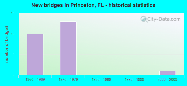
- New bridges - historical statistics
- 101960-1969
- 131970-1979
- 12000-2009

- Reconstructed bridges - Historical Statistics
- 31990-1999
- 02000-2009
- 12010-2019


- Bridge Condition - Deck
- 60.0%Good
- 10.0%Satisfactory
- 5.0%Fair
- 25.0%Poor

- Bridge Condition - Superstructure
- 65.0%Good
- 5.0%Satisfactory
- 5.0%Fair
- 25.0%Poor

- Bridge Condition - Substructure
- 10.0%Very good
- 80.0%Good
- 10.0%Satisfactory

- Bridge Condition - Channel
- 11.1%Very good
- 44.4%Good
- 22.2%Satisfactory
- 22.2%Fair
Find on map >> Show street view
Structure Number: 870011, Location: 0.3M N OF SW 244 ST (Lat: 25.540489, Lng: -80.407167), Route carried "on" structure: US 1, Year Built: 1966, Year Reconstructed: 2002, Status: Open, Structure Length: 2.10m (6.89ft), Average Daily Traffic: 19,500 (year 2020), Truck Traffic: 6%, Average Future Daily Traffic: 33,832 (year 2042), Design Load: HS 20, Features Intersected: PRINCETON CANAL C-102, Facility Carried by Structure: SR-5 SB
Minimum Vertical Clearance: 30+ m (98+ ft), Kilometerpoint: 14.109, Lanes on structure: 2, Owner: State Highway Agency, Approaching Roadway Width: 11.9m (39.0ft), Material/Design: Concrete, Design/Construction: Slab, Number Of Spans In Main Unit: 3, Length of Maximum Span: 7.0m (23.0ft), Curb or Sidewalk Widths: Left: 2.0m (6.6ft), Right: 0.0m, Curb-To-Curb Width: 12.3m (40.4ft), Out-to-Out Width: 15.2m (49.9ft)
Condition: Deck: Good, Superstructure: Good, Substructure: Good, Channel: Very good, Operating Rating: 65.7 metric tons, Method Used To Determine Operating Rating: Load Factor (LF), Inventory Rating: 39.4 metric tons, Method Used To Determine Inventory Rating: Load Factor (LF), Structural Evaluation: Better than present minimum criteria, Deck Geometry: Better than present minimum criteria, Waterway Adequacy: Equal to present desirable criteria, Approach Roadway Alignment: Equal to present desirable criteria, Length Of Structure Improvement: 0.20m (0.66ft), Designated Inspection Frequency: Every 24 months, Underwater Inspection Frequency: Every 24 months, Inspection Date: June 2021, Underwater Inspection Date: June 2021, Bridge Improvement Cost: $77,000, Total Project Cost: $77,000, Deck Structure Type: Concrete Cast-file-Place, Wearing Surface/Protective System: Wearing Surface: Bituminous
Find on map >> Show street view
Structure Number: 870173, Location: 5.3 MILES SOUTH OF US-1 (Lat: 25.525703, Lng: -80.398044), Route carried "on" structure: State highway 821, Year Built: 1973, Status: Open, Structure Length: 6.17m (20.24ft), Average Daily Traffic: 41,350 (year 2020), Truck Traffic: 8%, Average Future Daily Traffic: 71,742 (year 2042), Design Load: HS 20+Mod, Features Intersected: CANAL C-102
Minimum Vertical Clearance: 30+ m (98+ ft), Kilometerpoint: 12.038, Lanes on structure: 3, Base Highway Network: Yes, Toll: On toll road, Owner: State Toll Authority, Approaching Roadway Width: 17.6m (57.7ft), Skew: 4 degrees, Material/Design: Prestressed concrete, Design/Construction: Stringer/Multi-beam, Number Of Spans In Main Unit: 3, Length of Maximum Span: 20.6m (67.6ft), Curb-To-Curb Width: 17.4m (57.1ft), Out-to-Out Width: 18.1m (59.4ft)
Condition: Deck: Good, Superstructure: Good, Substructure: Good, Channel: Good, Operating Rating: 42.8 metric tons, Method Used To Determine Operating Rating: Load and Resistance Factor (LRFR), Inventory Rating: 39.6 metric tons, Method Used To Determine Inventory Rating: Load and Resistance Factor (LRFR), Structural Evaluation: Better than present minimum criteria, Deck Geometry: Better than present minimum criteria, Waterway Adequacy: Equal to present desirable criteria, Approach Roadway Alignment: Equal to present desirable criteria, Length Of Structure Improvement: 6.19m (20.31ft), Designated Inspection Frequency: Every 24 months, Inspection Date: Febuary 2020, Bridge Improvement Cost: $46,000, Total Project Cost: $46,000, Deck Structure Type: Concrete Cast-file-Place
Find on map >> Show street view
Structure Number: 870174, Location: 4.6 MILES SOUTH OF US-1 (Lat: 25.529517, Lng: -80.388317), Route carried "on" structure: State highway 821, Year Built: 1973, Status: Open, Structure Length: 4.16m (13.65ft), Average Daily Traffic: 41,350 (year 2020), Truck Traffic: 8%, Average Future Daily Traffic: 71,742 (year 2042), Design Load: HS 20+Mod, Features Intersected: CANAL C-102-N
Minimum Vertical Clearance: 30+ m (98+ ft), Kilometerpoint: 13.121, Lanes on structure: 3, Base Highway Network: Yes, Toll: On toll road, Owner: State Toll Authority, Approaching Roadway Width: 12.5m (41.0ft), Skew: 1 degrees, Material/Design: Prestressed concrete, Design/Construction: Stringer/Multi-beam, Number Of Spans In Main Unit: 3, Length of Maximum Span: 13.9m (45.6ft), Curb-To-Curb Width: 17.4m (57.1ft), Out-to-Out Width: 18.0m (59.1ft)
Condition: Deck: Good, Superstructure: Good, Substructure: Good, Channel: Good, Operating Rating: 53.4 metric tons, Method Used To Determine Operating Rating: Load Factor (LF), Inventory Rating: 32.1 metric tons, Method Used To Determine Inventory Rating: Load Factor (LF), Structural Evaluation: Better than present minimum criteria, Deck Geometry: Better than present minimum criteria, Waterway Adequacy: Equal to present desirable criteria, Approach Roadway Alignment: Equal to present desirable criteria, Designated Inspection Frequency: Every 24 months, Inspection Date: Febuary 2020, Deck Structure Type: Concrete Cast-file-Place
Find on map >> Show street view
Structure Number: 870175, Location: 3.6 MILES SOUTH OF US-1 (Lat: 25.532633, Lng: -80.372056), Route carried "on" structure: State highway 821, Year Built: 1973, Year Reconstructed: 2019, Status: Open, Structure Length: 6.19m (20.31ft), Average Daily Traffic: 41,350 (year 2020), Truck Traffic: 8%, Average Future Daily Traffic: 71,742 (year 2042), Design Load: HS 20, Features Intersected: SW 112 AVE ALLAPATTAH RD
Minimum Vertical Clearance: 30+ m (98+ ft), Kilometerpoint: 14.793, Lanes on structure: 4, Lanes under structure: 4, Base Highway Network: Yes, Toll: On toll road, Owner: State Toll Authority, Approaching Roadway Width: 25.0m (82.0ft), Skew: 2 degrees, Material/Design: Prestressed concrete, Design/Construction: Stringer/Multi-beam, Number Of Spans In Main Unit: 3, Length of Maximum Span: 33.2m (108.9ft), Curb-To-Curb Width: 25.0m (82.0ft), Out-to-Out Width: 25.9m (85.0ft)
Condition: Deck: Good, Superstructure: Good, Substructure: Good, Operating Rating: 44.7 metric tons, Method Used To Determine Operating Rating: Load and Resistance Factor (LRFR), Inventory Rating: 33.9 metric tons, Method Used To Determine Inventory Rating: Load and Resistance Factor (LRFR), Structural Evaluation: Better than present minimum criteria, Deck Geometry: Superior to present desirable criteria, Underclear: Meets minimum limits, Approach Roadway Alignment: Equal to present desirable criteria, Designated Inspection Frequency: Every 24 months, Inspection Date: March 2020, Deck Structure Type: Concrete Cast-file-Place
Find on map >> Show street view
Structure Number: 870176, Location: 3.1 MILES SOUTH OF US-1 (Lat: 25.537169, Lng: -80.366083), Route carried "on" structure: State highway 821, Year Built: 1973, Status: Open, Structure Length: 8.45m (27.72ft), Average Daily Traffic: 46,850 (year 2020), Truck Traffic: 8%, Average Future Daily Traffic: 81,285 (year 2042), Design Load: HS 20, Features Intersected: SW 248 ST & GOULDS CANAL
Minimum Vertical Clearance: 30+ m (98+ ft), Kilometerpoint: 15.588, Lanes on structure: 3, Lanes under structure: 4, Base Highway Network: Yes, Toll: On toll road, Owner: State Toll Authority, Approaching Roadway Width: 18.2m (59.7ft), Skew: 3 degrees, Material/Design: Prestressed concrete, Design/Construction: Stringer/Multi-beam, Number Of Spans In Main Unit: 3, Length of Maximum Span: 31.2m (102.4ft), Curb-To-Curb Width: 17.1m (56.1ft), Out-to-Out Width: 18.1m (59.4ft)
Condition: Deck: Good, Superstructure: Good, Substructure: Good, Channel: Good, Operating Rating: 41.5 metric tons, Method Used To Determine Operating Rating: Load and Resistance Factor (LRFR), Inventory Rating: 33.9 metric tons, Method Used To Determine Inventory Rating: Load and Resistance Factor (LRFR), Structural Evaluation: Better than present minimum criteria, Deck Geometry: Equal to present minimum criteria, Underclear: Somewhat better than minimum adequacy, Waterway Adequacy: Superior to present desirable criteria, Approach Roadway Alignment: Equal to present desirable criteria, Designated Inspection Frequency: Every 24 months, Inspection Date: March 2020, Deck Structure Type: Concrete Cast-file-Place
Find on map >> Show street view
Structure Number: 870229, Location: 0.3M N OF SW 244 ST (Lat: 25.540372, Lng: -80.407061), Route carried "on" structure: US 1, Year Built: 1965, Year Reconstructed: 2002, Status: Open, Structure Length: 2.10m (6.89ft), Average Daily Traffic: 19,500 (year 2020), Truck Traffic: 6%, Average Future Daily Traffic: 33,832 (year 2042), Design Load: HS 20, Features Intersected: PRINCETON CANAL C-102, Facility Carried by Structure: SR-5 NB (870229)
Minimum Vertical Clearance: 30+ m (98+ ft), Kilometerpoint: 14.109, Lanes on structure: 2, Owner: State Highway Agency, Approaching Roadway Width: 9.4m (30.8ft), Material/Design: Concrete, Design/Construction: Slab, Number Of Spans In Main Unit: 3, Length of Maximum Span: 7.0m (23.0ft), Curb or Sidewalk Widths: Left: 0.0m, Right: 2.0m (6.6ft), Curb-To-Curb Width: 9.6m (31.5ft), Out-to-Out Width: 12.8m (42.0ft)
Condition: Deck: Good, Superstructure: Good, Substructure: Good, Channel: Very good, Operating Rating: 61.6 metric tons, Method Used To Determine Operating Rating: Load Factor (LF), Inventory Rating: 36.9 metric tons, Method Used To Determine Inventory Rating: Load Factor (LF), Structural Evaluation: Better than present minimum criteria, Deck Geometry: Meets minimum limits, Waterway Adequacy: Equal to present desirable criteria, Approach Roadway Alignment: Equal to present desirable criteria, Designated Inspection Frequency: Every 24 months, Underwater Inspection Frequency: Every 24 months, Inspection Date: June 2021, Underwater Inspection Date: June 2021, Deck Structure Type: Concrete Cast-file-Place, Wearing Surface/Protective System: Wearing Surface: Bituminous
Find on map >> Show street view
Structure Number: 870384, Location: 5.3 MILES SOUTH OF US-1 (Lat: 25.525708, Lng: -80.397581), Route carried "on" structure: State highway 821, Year Built: 1973, Status: Open, Structure Length: 6.17m (20.24ft), Average Daily Traffic: 41,350 (year 2020), Truck Traffic: 8%, Average Future Daily Traffic: 71,742 (year 2042), Design Load: HS 20+Mod, Features Intersected: CANAL C-102
Minimum Vertical Clearance: 30+ m (98+ ft), Kilometerpoint: 12.081, Lanes on structure: 3, Base Highway Network: Yes, Toll: On toll road, Owner: State Toll Authority, Approaching Roadway Width: 13.2m (43.3ft), Skew: 4 degrees, Material/Design: Prestressed concrete, Design/Construction: Stringer/Multi-beam, Number Of Spans In Main Unit: 3, Length of Maximum Span: 20.6m (67.6ft), Curb-To-Curb Width: 17.4m (57.1ft), Out-to-Out Width: 18.1m (59.4ft)
Condition: Deck: Good, Superstructure: Good, Substructure: Good, Channel: Good, Operating Rating: 42.8 metric tons, Method Used To Determine Operating Rating: Load and Resistance Factor (LRFR), Inventory Rating: 39.6 metric tons, Method Used To Determine Inventory Rating: Load and Resistance Factor (LRFR), Structural Evaluation: Better than present minimum criteria, Deck Geometry: Better than present minimum criteria, Waterway Adequacy: Equal to present desirable criteria, Approach Roadway Alignment: Equal to present desirable criteria, Length Of Structure Improvement: 6.19m (20.31ft), Designated Inspection Frequency: Every 24 months, Inspection Date: Febuary 2020, Bridge Improvement Cost: $34,000, Total Project Cost: $34,000, Deck Structure Type: Concrete Cast-file-Place
Find on map >> Show street view
Structure Number: 870385, Location: 4.6 MILES SOUTH OF US-1 (Lat: 25.529214, Lng: -80.388314), Route carried "on" structure: State highway 821, Year Built: 1973, Status: Open, Structure Length: 4.18m (13.71ft), Average Daily Traffic: 41,350 (year 2020), Truck Traffic: 8%, Average Future Daily Traffic: 71,742 (year 2042), Design Load: HS 20+Mod, Features Intersected: CANAL C-102-N
Minimum Vertical Clearance: 30+ m (98+ ft), Kilometerpoint: 13.115, Lanes on structure: 3, Base Highway Network: Yes, Toll: On toll road, Owner: State Toll Authority, Approaching Roadway Width: 12.2m (40.0ft), Skew: 1 degrees, Material/Design: Prestressed concrete, Design/Construction: Stringer/Multi-beam, Number Of Spans In Main Unit: 3, Length of Maximum Span: 14.0m (45.9ft), Curb-To-Curb Width: 17.4m (57.1ft), Out-to-Out Width: 18.4m (60.4ft)
Condition: Deck: Good, Superstructure: Good, Substructure: Good, Channel: Good, Operating Rating: 53.4 metric tons, Method Used To Determine Operating Rating: Load Factor (LF), Inventory Rating: 32.1 metric tons, Method Used To Determine Inventory Rating: Load Factor (LF), Structural Evaluation: Better than present minimum criteria, Deck Geometry: Better than present minimum criteria, Waterway Adequacy: Equal to present desirable criteria, Approach Roadway Alignment: Equal to present desirable criteria, Designated Inspection Frequency: Every 24 months, Inspection Date: Febuary 2020, Deck Structure Type: Concrete Cast-file-Place
Find on map >> Show street view
Structure Number: 870386, Location: 3.6 MILES SOUTH OF US-1 (Lat: 25.532303, Lng: -80.372031), Route carried "on" structure: State highway 821, Year Built: 1973, Status: Open, Structure Length: 6.19m (20.31ft), Average Daily Traffic: 41,350 (year 2020), Truck Traffic: 8%, Average Future Daily Traffic: 71,742 (year 2042), Design Load: HS 20+Mod, Features Intersected: SW 112 AVE ALLAPATTAH RD
Minimum Vertical Clearance: 30+ m (98+ ft), Kilometerpoint: 14.774, Lanes on structure: 3, Lanes under structure: 5, Base Highway Network: Yes, Toll: On toll road, Owner: State Toll Authority, Approaching Roadway Width: 17.9m (58.7ft), Skew: 2 degrees, Material/Design: Prestressed concrete, Design/Construction: Stringer/Multi-beam, Number Of Spans In Main Unit: 3, Length of Maximum Span: 33.2m (108.9ft), Curb-To-Curb Width: 17.0m (55.8ft), Out-to-Out Width: 18.0m (59.1ft)
Condition: Deck: Satisfactory, Superstructure: Good, Substructure: Good, Operating Rating: 35.3 metric tons, Method Used To Determine Operating Rating: Load and Resistance Factor (LRFR), Inventory Rating: 29.8 metric tons, Method Used To Determine Inventory Rating: Load and Resistance Factor (LRFR), Structural Evaluation: Better than present minimum criteria, Deck Geometry: Equal to present minimum criteria, Underclear: Meets minimum limits, Approach Roadway Alignment: Equal to present desirable criteria, Designated Inspection Frequency: Every 24 months, Inspection Date: March 2020, Deck Structure Type: Concrete Cast-file-Place
Find on map >> Show street view
Structure Number: 870387, Location: 3.1 MILES SOUTH OF US-1 (Lat: 25.537183, Lng: -80.365692), Route carried "on" structure: State highway 821, Year Built: 1973, Status: Open, Structure Length: 8.35m (27.40ft), Average Daily Traffic: 46,850 (year 2020), Truck Traffic: 8%, Average Future Daily Traffic: 81,285 (year 2042), Design Load: HS 20, Features Intersected: SW 248 ST & GOULDS CANAL
Minimum Vertical Clearance: 30+ m (98+ ft), Kilometerpoint: 15.622, Lanes on structure: 3, Lanes under structure: 4, Base Highway Network: Yes, Toll: On toll road, Owner: State Toll Authority, Approaching Roadway Width: 18.2m (59.7ft), Skew: 3 degrees, Material/Design: Prestressed concrete, Design/Construction: Stringer/Multi-beam, Number Of Spans In Main Unit: 3, Length of Maximum Span: 31.4m (103.0ft), Curb-To-Curb Width: 17.1m (56.1ft), Out-to-Out Width: 18.0m (59.1ft)
Condition: Deck: Good, Superstructure: Good, Substructure: Good, Channel: Good, Operating Rating: 41.5 metric tons, Method Used To Determine Operating Rating: Load and Resistance Factor (LRFR), Inventory Rating: 33.9 metric tons, Method Used To Determine Inventory Rating: Load and Resistance Factor (LRFR), Structural Evaluation: Better than present minimum criteria, Deck Geometry: Equal to present minimum criteria, Underclear: Somewhat better than minimum adequacy, Waterway Adequacy: Equal to present desirable criteria, Approach Roadway Alignment: Equal to present desirable criteria, Designated Inspection Frequency: Every 24 months, Other Special Inspection Frequency: Every 14 months, Inspection Date: March 2020, Other Special Inspection Date: January 2021, Deck Structure Type: Concrete Cast-file-Place
Find on map >> Show street view
Structure Number: 870979, Location: N SW 244-Bus Way / US-1 (Lat: 25.540614, Lng: -80.407339), Route carried "on" structure: Other road , Year Built: 2005, Status: Open, Structure Length: 1.80m (5.91ft), Design Load: HS 20, Features Intersected: Canal C-102, Facility Carried by Structure: Busway Extension
Minimum Vertical Clearance: 30+ m (98+ ft), Kilometerpoint: 13.140, Lanes on structure: 2, Owner: County Highway Agency, Approaching Roadway Width: 11.0m (36.1ft), Material/Design: Prestressed concrete, Design/Construction: Tee Beam, Number Of Spans In Main Unit: 3, Length of Maximum Span: 8.6m (28.2ft), Curb or Sidewalk Widths: Left: 3.2m (10.5ft), Right: 0.0m, Curb-To-Curb Width: 13.3m (43.6ft), Out-to-Out Width: 17.7m (58.1ft)
Condition: Deck: Good, Superstructure: Good, Substructure: Good, Channel: Satisfactory, Inventory Rating: 84.7 metric tons, Method Used To Determine Inventory Rating: Load Factor (LF), Structural Evaluation: Better than present minimum criteria, Deck Geometry: Superior to present desirable criteria, Waterway Adequacy: Equal to present desirable criteria, Approach Roadway Alignment: Equal to present desirable criteria, Designated Inspection Frequency: Every 24 months, Underwater Inspection Frequency: Every 24 months, Inspection Date: December 2021, Underwater Inspection Date: December 2021, Deck Structure Type: Concrete Cast-file-Place, Wearing Surface/Protective System: Wearing Surface: Integral Concrete
Find on map >> Show street view
Structure Number: 874319, Location: 1/4 Mi. N of SW 264th St. (Lat: 25.525767, Lng: -80.393950), Route carried "on" structure: County highway , Year Built: 1975, Status: Open, Structure Length: 2.20m (7.22ft), Average Daily Traffic: 575 (year 2021), Truck Traffic: 2%, Average Future Daily Traffic: 936 (year 2042), Design Load: HL 93, Features Intersected: Canal C-102, Facility Carried by Structure: SW 125th Avenue
Minimum Vertical Clearance: 30+ m (98+ ft), Kilometerpoint: 0.000, Lanes on structure: 2, Owner: County Highway Agency, Approaching Roadway Width: 6.7m (22.0ft), Material/Design: Prestressed concrete, Design/Construction: Slab, Number Of Spans In Main Unit: 3, Length of Maximum Span: 8.4m (27.6ft), Curb or Sidewalk Widths: Left: 1.5m (4.9ft), Right: 1.5m (4.9ft), Curb-To-Curb Width: 8.5m (27.9ft), Out-to-Out Width: 12.2m (40.0ft)
Condition: Deck: Good, Superstructure: Good, Substructure: Good, Channel: Fair, Operating Rating: 68.5 metric tons, Method Used To Determine Operating Rating: Load and Resistance Factor (LRFR), Inventory Rating: 52.9 metric tons, Method Used To Determine Inventory Rating: Load and Resistance Factor (LRFR), Structural Evaluation: Better than present minimum criteria, Deck Geometry: Somewhat better than minimum adequacy, Waterway Adequacy: Equal to present desirable criteria, Approach Roadway Alignment: Equal to present desirable criteria, Designated Inspection Frequency: Every 24 months, Underwater Inspection Frequency: Every 24 months, Inspection Date: November 2021, Underwater Inspection Date: November 2021, Deck Structure Type: Concrete Precast Panels, Wearing Surface/Protective System: Wearing Surface: Bituminous
Find on map >> Show street view
Structure Number: 874414, Location: 0.4Miles N of SW 268th St (Lat: 25.523806, Lng: -80.372000), Route carried "on" structure: County highway , Year Built: 1965, Status: Open, Structure Length: 2.29m (7.51ft), Average Daily Traffic: 11,850 (year 2020), Truck Traffic: 5%, Average Future Daily Traffic: 26,550 (year 2042), Design Load: H 20, Features Intersected: PRINCETON CANAL C-102, Facility Carried by Structure: SW 112th AVENUE
Minimum Vertical Clearance: 30+ m (98+ ft), Kilometerpoint: 1.801, Lanes on structure: 4, Owner: County Highway Agency, Approaching Roadway Width: 14.3m (46.9ft), Material/Design: Concrete, Design/Construction: Slab, Number Of Spans In Main Unit: 3, Length of Maximum Span: 7.2m (23.6ft), Curb or Sidewalk Widths: Left: 1.0m (3.3ft), Right: 1.0m (3.3ft), Curb-To-Curb Width: 16.6m (54.5ft), Out-to-Out Width: 19.0m (62.3ft)
Condition: Deck: Satisfactory, Superstructure: Satisfactory, Substructure: Good, Channel: Fair, Operating Rating: 51.0 metric tons, Method Used To Determine Operating Rating: Load Factor (LF), Inventory Rating: 30.6 metric tons, Method Used To Determine Inventory Rating: Load Factor (LF), Structural Evaluation: Equal to present minimum criteria, Deck Geometry: Somewhat better than minimum adequacy, Waterway Adequacy: Better than present minimum criteria, Approach Roadway Alignment: Equal to present desirable criteria, Designated Inspection Frequency: Every 24 months, Underwater Inspection Frequency: Every 24 months, Inspection Date: May 2021, Underwater Inspection Date: May 2021, Deck Structure Type: Concrete Cast-file-Place, Wearing Surface/Protective System: Wearing Surface: Bituminous
Find on map >> Show street view
Structure Number: 874445, Location: 1 Mile W of US-1 (Lat: 25.551283, Lng: -80.411167), Route carried "on" structure: County highway , Year Built: 1966, Status: Open, Structure Length: 1.67m (5.48ft), Average Daily Traffic: 4,543 (year 2020), Truck Traffic: 5%, Average Future Daily Traffic: 7,882 (year 2042), Design Load: HL 93, Features Intersected: Canal C-102, Facility Carried by Structure: SW 232nd Street
Minimum Vertical Clearance: 30+ m (98+ ft), Kilometerpoint: 0.171, Lanes on structure: 2, Owner: County Highway Agency, Approaching Roadway Width: 6.7m (22.0ft), Material/Design: Prestressed concrete, Design/Construction: Slab, Number Of Spans In Main Unit: 2, Length of Maximum Span: 8.3m (27.2ft), Curb or Sidewalk Widths: Left: 1.2m (3.9ft), Right: 1.2m (3.9ft), Curb-To-Curb Width: 8.6m (28.2ft), Out-to-Out Width: 11.0m (36.1ft)
Condition: Deck: Poor, Superstructure: Poor, Substructure: Good, Channel: Satisfactory, Operating Rating: 50.8 metric tons, Method Used To Determine Operating Rating: Load and Resistance Factor (LRFR), Inventory Rating: 39.2 metric tons, Method Used To Determine Inventory Rating: Load and Resistance Factor (LRFR), Structural Evaluation: Meets minimum limits, Deck Geometry: Meets minimum limits, Waterway Adequacy: Better than present minimum criteria, Approach Roadway Alignment: Equal to present desirable criteria, Designated Inspection Frequency: Every 24 months, Underwater Inspection Frequency: Every 24 months, Other Special Inspection Frequency: Every 12 months, Inspection Date: May 2021, Underwater Inspection Date: May 2021, Other Special Inspection Date: May 2021, Deck Structure Type: Concrete Precast Panels, Wearing Surface/Protective System: Wearing Surface: Bituminous
Find on map >> Show street view
Structure Number: 874446, Location: 0.4 Miles E of US-1 (Lat: 25.536564, Lng: -80.404753), Route carried "on" structure: County highway , Year Built: 1966, Status: Open, Structure Length: 1.83m (6.00ft), Average Daily Traffic: 5,239 (year 2020), Truck Traffic: 2%, Average Future Daily Traffic: 8,526 (year 2042), Design Load: HS 20, Features Intersected: Canal C-102, Facility Carried by Structure: SW 248th Street
Minimum Vertical Clearance: 30+ m (98+ ft), Kilometerpoint: 0.628, Lanes on structure: 2, Owner: County Highway Agency, Approaching Roadway Width: 7.3m (24.0ft), Material/Design: Prestressed concrete, Design/Construction: Slab, Number Of Spans In Main Unit: 2, Length of Maximum Span: 9.1m (29.9ft), Curb or Sidewalk Widths: Left: 1.2m (3.9ft), Right: 1.2m (3.9ft), Curb-To-Curb Width: 8.6m (28.2ft), Out-to-Out Width: 11.6m (38.1ft)
Condition: Deck: Poor, Superstructure: Poor, Substructure: Good, Channel: Good, Operating Rating: 64.9 metric tons, Method Used To Determine Operating Rating: Load Factor (LF), Inventory Rating: 38.7 metric tons, Method Used To Determine Inventory Rating: Load Factor (LF), Structural Evaluation: Meets minimum limits, Deck Geometry: High priority of replacement, Waterway Adequacy: Equal to present desirable criteria, Approach Roadway Alignment: Equal to present desirable criteria, Designated Inspection Frequency: Every 24 months, Underwater Inspection Frequency: Every 24 months, Other Special Inspection Frequency: Every 12 months, Inspection Date: May 2021, Underwater Inspection Date: May 2021, Other Special Inspection Date: May 2021, Deck Structure Type: Concrete Precast Panels, Wearing Surface/Protective System: Wearing Surface: Bituminous
Find on map >> Show street view
Structure Number: 874447, Location: 0.6 Mi E of SW 137th Ave. (Lat: 25.529261, Lng: -80.402414), Route carried "on" structure: County highway , Year Built: 1966, Year Reconstructed: 1997, Status: Open, Structure Length: 2.08m (6.82ft), Average Daily Traffic: 3,465 (year 2021), Truck Traffic: 3%, Average Future Daily Traffic: 5,879 (year 2042), Design Load: H 20, Features Intersected: Canal C-102, Facility Carried by Structure: SW 256th Street
Minimum Vertical Clearance: 30+ m (98+ ft), Kilometerpoint: 1.436, Lanes on structure: 2, Owner: County Highway Agency, Approaching Roadway Width: 7.3m (24.0ft), Skew: 2 degrees, Material/Design: Prestressed concrete, Design/Construction: Slab, Number Of Spans In Main Unit: 2, Length of Maximum Span: 10.4m (34.1ft), Curb or Sidewalk Widths: Left: 1.6m (5.2ft), Right: 1.6m (5.2ft), Curb-To-Curb Width: 9.1m (29.9ft), Out-to-Out Width: 13.7m (44.9ft)
Condition: Deck: Poor, Superstructure: Poor, Substructure: Good, Channel: Satisfactory, Operating Rating: 41.8 metric tons, Method Used To Determine Operating Rating: Load Factor (LF), Inventory Rating: 25.6 metric tons, Method Used To Determine Inventory Rating: Load Factor (LF), Structural Evaluation: Meets minimum limits, Deck Geometry: Meets minimum limits, Waterway Adequacy: Better than present minimum criteria, Approach Roadway Alignment: Equal to present desirable criteria, Designated Inspection Frequency: Every 24 months, Underwater Inspection Frequency: Every 24 months, Other Special Inspection Frequency: Every 12 months, Inspection Date: December 2021, Underwater Inspection Date: December 2021, Other Special Inspection Date: December 2021, Deck Structure Type: Concrete Precast Panels, Wearing Surface/Protective System: Wearing Surface: Bituminous
Find on map >> Show street view
Structure Number: 874448, Location: 300Ft. N of SW 268th St. (Lat: 25.519544, Lng: -80.363936), Route carried "on" structure: County highway , Year Built: 1965, Status: Open, Structure Length: 1.98m (6.50ft), Average Daily Traffic: 661 (year 2022), Truck Traffic: 2%, Average Future Daily Traffic: 1,105 (year 2042), Design Load: HS 20, Features Intersected: Canal C-102, Facility Carried by Structure: SW 107th Avenue
Minimum Vertical Clearance: 30+ m (98+ ft), Kilometerpoint: 0.082, Lanes on structure: 2, Owner: County Highway Agency, Approaching Roadway Width: 7.8m (25.6ft), Material/Design: Prestressed concrete, Design/Construction: Slab, Number Of Spans In Main Unit: 3, Length of Maximum Span: 7.9m (25.9ft), Curb or Sidewalk Widths: Left: 1.2m (3.9ft), Right: 1.2m (3.9ft), Curb-To-Curb Width: 8.6m (28.2ft), Out-to-Out Width: 11.7m (38.4ft)
Condition: Deck: Poor, Superstructure: Poor, Substructure: Satisfactory, Channel: Fair, Operating Rating: 67.5 metric tons, Method Used To Determine Operating Rating: Load Factor (LF), Inventory Rating: 40.4 metric tons, Method Used To Determine Inventory Rating: Load Factor (LF), Structural Evaluation: Meets minimum limits, Deck Geometry: Somewhat better than minimum adequacy, Waterway Adequacy: Better than present minimum criteria, Approach Roadway Alignment: Equal to present desirable criteria, Designated Inspection Frequency: Every 24 months, Underwater Inspection Frequency: Every 24 months, Other Special Inspection Frequency: Every 12 months, Inspection Date: December 2021, Underwater Inspection Date: December 2021, Other Special Inspection Date: December 2021, Deck Structure Type: Concrete Precast Panels, Wearing Surface/Protective System: Wearing Surface: Integral Concrete
Find on map >> Show street view
Structure Number: 874449, Location: 0.3 Mi S of SW 232nd St (Lat: 25.546750, Lng: -80.392444), Route carried "on" structure: County highway , Year Built: 1966, Status: Open, Structure Length: 1.51m (4.95ft), Average Daily Traffic: 323 (year 2016), Truck Traffic: 1%, Average Future Daily Traffic: 528 (year 2039), Design Load: HL 93, Features Intersected: Canal C-102-N, Facility Carried by Structure: SW 124th Avenue
Minimum Vertical Clearance: 30+ m (98+ ft), Kilometerpoint: 1.098, Lanes on structure: 2, Owner: County Highway Agency, Approaching Roadway Width: 7.2m (23.6ft), Material/Design: Prestressed concrete, Design/Construction: Slab, Number Of Spans In Main Unit: 1, Length of Maximum Span: 15.1m (49.5ft), Curb or Sidewalk Widths: Left: 1.2m (3.9ft), Right: 1.2m (3.9ft), Curb-To-Curb Width: 7.9m (25.9ft), Out-to-Out Width: 11.0m (36.1ft)
Condition: Deck: Poor, Superstructure: Poor, Substructure: Very good, Channel: Good, Operating Rating: 38.1 metric tons, Method Used To Determine Operating Rating: Load and Resistance Factor (LRFR), Inventory Rating: 29.4 metric tons, Method Used To Determine Inventory Rating: Load and Resistance Factor (LRFR), Structural Evaluation: Meets minimum limits, Deck Geometry: Somewhat better than minimum adequacy, Waterway Adequacy: Better than present minimum criteria, Approach Roadway Alignment: Equal to present desirable criteria, Designated Inspection Frequency: Every 24 months, Other Special Inspection Frequency: Every 12 months, Inspection Date: March 2020, Other Special Inspection Date: March 2021, Deck Structure Type: Concrete Precast Panels, Wearing Surface/Protective System: Wearing Surface: Bituminous
Find on map >> Show street view
Structure Number: 87445, Location: 1.3 Miles East of US 1 (Lat: 25.536831, Lng: -80.389394), Route carried "on" structure: County highway , Year Built: 1966, Status: Open, Structure Length: 1.55m (5.09ft), Average Daily Traffic: 5,306 (year 2014), Truck Traffic: 10%, Average Future Daily Traffic: 7,140 (year 2039), Design Load: HS 20, Features Intersected: Canal C-102-N, Facility Carried by Structure: SW 248th Street
Minimum Vertical Clearance: 30+ m (98+ ft), Kilometerpoint: 2.182, Lanes on structure: 2, Owner: County Highway Agency, Approaching Roadway Width: 7.1m (23.3ft), Material/Design: Prestressed concrete, Design/Construction: Slab, Number Of Spans In Main Unit: 1, Length of Maximum Span: 15.5m (50.9ft), Curb or Sidewalk Widths: Left: 1.2m (3.9ft), Right: 1.2m (3.9ft), Curb-To-Curb Width: 10.6m (34.8ft), Out-to-Out Width: 11.2m (36.7ft)
Condition: Deck: Good, Superstructure: Good, Substructure: Very good, Channel: Satisfactory, Operating Rating: 84.7 metric tons, Method Used To Determine Operating Rating: Load Factor (LF), Inventory Rating: 50.8 metric tons, Method Used To Determine Inventory Rating: Load Factor (LF), Structural Evaluation: Better than present minimum criteria, Deck Geometry: Meets minimum limits, Waterway Adequacy: Better than present minimum criteria, Approach Roadway Alignment: Equal to present desirable criteria, Designated Inspection Frequency: Every 24 months, Inspection Date: May 2020, Deck Structure Type: Concrete Precast Panels, Wearing Surface/Protective System: Wearing Surface: Monolithic Concrete
Find on map >> Show street view
Structure Number: 874479, Location: 50Ft. E of SW 97th Avenue (Lat: 25.529722, Lng: -80.347111), Route carried "on" structure: City street , Year Built: 1967, Status: Closed, Structure Length: 1.37m (4.49ft), Design Load: HS 20, Features Intersected: Levee L-31E Barrow Canal, Facility Carried by Structure: SW 256th Street
Minimum Vertical Clearance: 30+ m (98+ ft), Kilometerpoint: 0.000, Lanes on structure: 2, Owner: County Highway Agency, Approaching Roadway Width: 6.3m (20.7ft), Material/Design: Prestressed concrete, Design/Construction: Slab, Number Of Spans In Main Unit: 1, Length of Maximum Span: 13.7m (44.9ft), Curb-To-Curb Width: 6.3m (20.7ft), Out-to-Out Width: 6.3m (20.7ft)
Condition: Deck: Fair, Superstructure: Fair, Substructure: Satisfactory, Channel: Fair, Deck Geometry: Somewhat better than minimum adequacy, Waterway Adequacy: Better than present minimum criteria, Designated Inspection Frequency: Every 24 months, Inspection Date: November 2021, Deck Structure Type: Concrete Precast Panels, Wearing Surface/Protective System: Wearing Surface: Bituminous
Find on map >> Show street view
Structure Number: 870175, Location: 3.6 MILES SOUTH OF US-1 (Lat: 25.532633, Lng: -80.372056), Route carried "under" structure: State highway 989, Year Built: 1973, Structure Length: 0. m, Average Daily Traffic: 41,350 (year 2020), Truck Traffic: 8%, Features Intersected: SW 112 AVE ALLAPATTAH RD, Facility Carried by Structure: SR821 SB HEFT 9.14
Minimum Vertical Clearance: 5.15m (16.90ft), Kilometerpoint: 14.793, Lanes on structure: 4, Lanes under structure: 4, Material/Design: Prestressed concrete, Design/Construction: Stringer/Multi-beam, Length of Maximum Span: 33.2m (108.9ft)
Find on map >> Show street view
Structure Number: 870176, Location: 3.1 MILES SOUTH OF US-1 (Lat: 25.537169, Lng: -80.366083), Route carried "under" structure: City street , Year Built: 1973, Structure Length: 0. m, Average Daily Traffic: 46,850 (year 2020), Truck Traffic: 8%, Features Intersected: SW 248 ST & GOULDS CANAL, Facility Carried by Structure: SR821 SB HEFT 9.63
Minimum Vertical Clearance: 5.03m (16.50ft), Kilometerpoint: 15.578, Lanes on structure: 3, Lanes under structure: 4, Material/Design: Prestressed concrete, Design/Construction: Stringer/Multi-beam, Length of Maximum Span: 31.2m (102.4ft)
Find on map >> Show street view
Structure Number: 870386, Location: 3.6 MILES SOUTH OF US-1 (Lat: 25.532303, Lng: -80.372031), Route carried "under" structure: State highway 989, Year Built: 1973, Structure Length: 0. m, Average Daily Traffic: 41,350 (year 2020), Truck Traffic: 8%, Features Intersected: SW 112 AVE ALLAPATTAH RD, Facility Carried by Structure: SR821 NB HEFT 9.13
Minimum Vertical Clearance: 5.15m (16.90ft), Kilometerpoint: 14.774, Lanes on structure: 3, Lanes under structure: 4, Material/Design: Prestressed concrete, Design/Construction: Stringer/Multi-beam, Length of Maximum Span: 33.2m (108.9ft)
Find on map >> Show street view
Structure Number: 870387, Location: 3.1 MILES SOUTH OF US-1 (Lat: 25.537183, Lng: -80.365692), Route carried "under" structure: City street , Year Built: 1973, Structure Length: 0. m, Average Daily Traffic: 46,850 (year 2020), Truck Traffic: 8%, Features Intersected: SW 248 ST & GOULDS CANAL, Facility Carried by Structure: SR821 NB HEFT 9.66
Minimum Vertical Clearance: 5.03m (16.50ft), Kilometerpoint: 15.622, Lanes on structure: 3, Lanes under structure: 4, Material/Design: Prestressed concrete, Design/Construction: Stringer/Multi-beam, Length of Maximum Span: 31.4m (103.0ft)