Bridge Statistics for Post Falls, Idaho (ID)
Condition, Traffic, Stress, Structural Evaluation, Project Costs
- National Bridge Inventory (NBI) Statistics
- 31Number of bridges
- 407ft / 124mTotal length
- $1,533,000Total costs
- 691,895Total average daily traffic
- 47,599Total average daily truck traffic
- National Bridge Inventory (NBI) Registered Bridges for Post Falls
- No street view available for this location
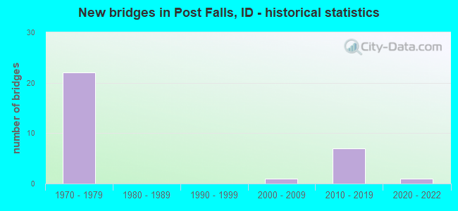
- New bridges - historical statistics
- 221970-1979
- 12000-2009
- 72010-2019
- 12020-2022


- Bridge Condition - Deck
- 5.6%Excellent
- 5.6%Very good
- 50.0%Good
- 38.9%Satisfactory

- Bridge Condition - Superstructure
- 5.6%Excellent
- 27.8%Very good
- 27.8%Good
- 38.9%Satisfactory

- Bridge Condition - Substructure
- 5.6%Excellent
- 11.1%Very good
- 11.1%Good
- 72.2%Satisfactory

- Bridge Condition - Channel
- 33.3%Very good
- 66.7%Good
Find on map >> Show street view
Structure Number: 14246, Location: 1.5 N. POST FALLS (Lat: 47.766083, Lng: -116.894139), Route carried "on" structure: State highway 41, Year Built: 2021, Status: Open, Structure Length: 4.30m (14.11ft), Average Daily Traffic: 6,750 (year 2021), Truck Traffic: 6%, Average Future Daily Traffic: 10,125 (year 2041), Design Load: HL 93, Features Intersected: UPRR MAINLINE
Minimum Vertical Clearance: 30+ m (98+ ft), Kilometerpoint: 6.282, Lanes on structure: 2, Base Highway Network: Yes, Owner: State Highway Agency, Approaching Roadway Width: 11.6m (38.1ft), Skew: 3 degrees, Material/Design: Prestressed concrete, Design/Construction: Stringer/Multi-beam, Number Of Spans In Main Unit: 1, Length of Maximum Span: 41.8m (137.1ft), Curb or Sidewalk Widths: Left: 0.0m, Right: 3.7m (12.1ft), Curb-To-Curb Width: 12.0m (39.4ft), Out-to-Out Width: 16.7m (54.8ft)
Condition: Deck: Excellent, Superstructure: Excellent, Substructure: Excellent, Operating Rating: 41.7 metric tons, Method Used To Determine Operating Rating: No rating analysis performed, Inventory Rating: 32.7 metric tons, Method Used To Determine Inventory Rating: No rating analysis performed, Structural Evaluation: Superior to present desirable criteria, Deck Geometry: Somewhat better than minimum adequacy, Underclear: Superior to present desirable criteria, Approach Roadway Alignment: Equal to present desirable criteria, Designated Inspection Frequency: Every 24 months, Inspection Date: August 2021, Deck Structure Type: Concrete Cast-file-Place, Wearing Surface/Protective System: Wearing Surface: Monolithic Concrete, Deck Protection: Epoxy Coated Reinforcing
Find on map >> Show street view
Structure Number: 16735, Location: AT IDAHO WASH.STATE LINE (Lat: 47.697111, Lng: -117.040139), Route carried "on" structure: Interstate 90, Year Built: 1976, Status: Open, Structure Length: 14.17m (46.49ft), Average Daily Traffic: 30,500 (year 2019), Truck Traffic: 8%, Average Future Daily Traffic: 45,750 (year 2039), Design Load: HS 20, Features Intersected: SPOKANE RIVER
Minimum Vertical Clearance: 30+ m (98+ ft), Kilometerpoint: 0.000, Lanes on structure: 2, Base Highway Network: Yes (Inventory Route: I, Subroute: 1), Owner: State Highway Agency, Approaching Roadway Width: 11.6m (38.1ft), Skew: 3 degrees, Navigation Control: Yes ( Vertical Clearance: 8.0m (26.2ft), Horizontal Clearance: 22.0m (72.2ft)), Material/Design: Prestressed concrete continuous, Design/Construction: Stringer/Multi-beam, Number Of Spans In Main Unit: 5, Length of Maximum Span: 28.0m (91.9ft), Curb-To-Curb Width: 12.4m (40.7ft), Out-to-Out Width: 13.3m (43.6ft)
Condition: Deck: Good, Superstructure: Very good, Substructure: Satisfactory, Channel: Good, Operating Rating: 60.8 metric tons, Method Used To Determine Operating Rating: Load Factor (LF), Inventory Rating: 29.0 metric tons, Method Used To Determine Inventory Rating: Load Factor (LF), Structural Evaluation: Equal to present minimum criteria, Deck Geometry: Better than present minimum criteria, Waterway Adequacy: Superior to present desirable criteria, Approach Roadway Alignment: Equal to present desirable criteria, Designated Inspection Frequency: Every 24 months, Underwater Inspection Frequency: Every 60 months, Inspection Date: March 2021, Underwater Inspection Date: September 2021, Deck Structure Type: Concrete Cast-file-Place, Wearing Surface/Protective System: Wearing Surface: Epoxy Overlay
Find on map >> Show street view
Structure Number: 1674, Location: AT IDAHO WASH.STATE LINE (Lat: 47.696611, Lng: -117.041583), Route carried "on" structure: Interstate 90, Year Built: 1976, Status: Open, Structure Length: 14.17m (46.49ft), Average Daily Traffic: 30,500 (year 2019), Truck Traffic: 8%, Average Future Daily Traffic: 45,750 (year 2039), Design Load: HS 20, Features Intersected: SPOKANE RIVER
Minimum Vertical Clearance: 30+ m (98+ ft), Kilometerpoint: 0.002, Lanes on structure: 2, Base Highway Network: Yes (Inventory Route: I, Subroute: 1), Owner: State Highway Agency, Approaching Roadway Width: 11.6m (38.1ft), Skew: 3 degrees, Navigation Control: Yes ( Vertical Clearance: 8.0m (26.2ft), Horizontal Clearance: 22.0m (72.2ft)), Material/Design: Prestressed concrete continuous, Design/Construction: Stringer/Multi-beam, Number Of Spans In Main Unit: 5, Length of Maximum Span: 28.0m (91.9ft), Curb-To-Curb Width: 14.7m (48.2ft), Out-to-Out Width: 17.0m (55.8ft)
Condition: Deck: Good, Superstructure: Very good, Substructure: Satisfactory, Channel: Good, Operating Rating: 57.2 metric tons, Method Used To Determine Operating Rating: Load Factor (LF), Inventory Rating: 29.0 metric tons, Method Used To Determine Inventory Rating: Load Factor (LF), Structural Evaluation: Equal to present minimum criteria, Deck Geometry: Superior to present desirable criteria, Waterway Adequacy: Superior to present desirable criteria, Approach Roadway Alignment: Equal to present desirable criteria, Designated Inspection Frequency: Every 24 months, Underwater Inspection Frequency: Every 60 months, Inspection Date: March 2021, Underwater Inspection Date: September 2021, Deck Structure Type: Concrete Cast-file-Place, Wearing Surface/Protective System: Wearing Surface: Epoxy Overlay
Find on map >> Show street view
Structure Number: 16742, Location: 0.96 E. IDA-WA LINE (Lat: 47.701167, Lng: -117.019361), Route carried "on" structure: County highway 7227, Year Built: 2012, Status: Open, Structure Length: 7.28m (23.88ft), Average Daily Traffic: 6,000 (year 2019), Average Future Daily Traffic: 9,000 (year 2039), Design Load: HL 93, Features Intersected: I 90; POINTE PARKWAY IC
Minimum Vertical Clearance: 30+ m (98+ ft), Kilometerpoint: 162.159, Lanes on structure: 6, Lanes under structure: 4, Owner: State Highway Agency, Approaching Roadway Width: 23.2m (76.1ft), Material/Design: Prestressed concrete, Design/Construction: Stringer/Multi-beam, Number Of Spans In Main Unit: 2, Length of Maximum Span: 36.0m (118.1ft), Curb or Sidewalk Widths: Left: 2.0m (6.6ft), Right: 2.0m (6.6ft), Curb-To-Curb Width: 27.1m (88.9ft), Out-to-Out Width: 31.6m (103.7ft)
Condition: Deck: Good, Superstructure: Very good, Substructure: Very good, Operating Rating: 51.2 metric tons, Method Used To Determine Operating Rating: Load and Resistance Factor Rating (LRFR) rating reported by rating factor(RF) method using HL-93 loadings, Inventory Rating: 39.5 metric tons, Method Used To Determine Inventory Rating: Load and Resistance Factor Rating (LRFR) rating reported by rating factor(RF) method using HL-93 loadings, Structural Evaluation: Equal to present desirable criteria, Deck Geometry: Better than present minimum criteria, Underclear: Somewhat better than minimum adequacy, Approach Roadway Alignment: Equal to present desirable criteria, Designated Inspection Frequency: Every 48 months, Inspection Date: October 2018, Deck Structure Type: Concrete Cast-file-Place, Wearing Surface/Protective System: Wearing Surface: Epoxy Overlay, Deck Protection: Epoxy Coated Reinforcing
Find on map >> Show street view
Structure Number: 16745, Location: 2.1 E. IDA-WA LINE (Lat: 47.709056, Lng: -117.002056), Route carried "on" structure: Interstate 90, Year Built: 1976, Status: Open, Structure Length: 4.91m (16.11ft), Average Daily Traffic: 28,750 (year 2019), Truck Traffic: 7%, Average Future Daily Traffic: 43,125 (year 2039), Design Load: HS 20, Features Intersected: S 8505;PLEASANT VIEW IC
Minimum Vertical Clearance: 30+ m (98+ ft), Kilometerpoint: 3.326, Lanes on structure: 2, Lanes under structure: 4, Base Highway Network: Yes (Inventory Route: I, Subroute: 1), Owner: State Highway Agency, Approaching Roadway Width: 11.6m (38.1ft), Skew: 1 degrees, Material/Design: Prestressed concrete, Design/Construction: Stringer/Multi-beam, Number Of Spans In Main Unit: 3, Length of Maximum Span: 22.3m (73.2ft), Curb-To-Curb Width: 12.4m (40.7ft), Out-to-Out Width: 13.3m (43.6ft)
Condition: Deck: Good, Superstructure: Good, Substructure: Satisfactory, Operating Rating: 59.0 metric tons, Method Used To Determine Operating Rating: Load Factor (LF), Inventory Rating: 35.4 metric tons, Method Used To Determine Inventory Rating: Load Factor (LF), Structural Evaluation: Equal to present minimum criteria, Deck Geometry: Better than present minimum criteria, Underclear: High priority of corrective action, Approach Roadway Alignment: Equal to present desirable criteria, Designated Inspection Frequency: Every 24 months, Inspection Date: March 2020, Deck Structure Type: Concrete Cast-file-Place, Wearing Surface/Protective System: Wearing Surface: Epoxy Overlay, Deck Protection: Epoxy Coated Reinforcing
Find on map >> Show street view
Structure Number: 1675, Location: 2.1 E. IDA-WA LINE (Lat: 47.709500, Lng: -117.001450), Route carried "on" structure: Interstate 90, Year Built: 1976, Status: Open, Structure Length: 4.91m (16.11ft), Average Daily Traffic: 28,750 (year 2019), Truck Traffic: 7%, Average Future Daily Traffic: 43,125 (year 2039), Design Load: HS 20, Features Intersected: S 8505;PLEASANT VIEW IC
Minimum Vertical Clearance: 30+ m (98+ ft), Kilometerpoint: 3.328, Lanes on structure: 2, Lanes under structure: 4, Base Highway Network: Yes (Inventory Route: I, Subroute: 1), Owner: State Highway Agency, Approaching Roadway Width: 11.6m (38.1ft), Skew: 1 degrees, Material/Design: Prestressed concrete, Design/Construction: Stringer/Multi-beam, Number Of Spans In Main Unit: 3, Length of Maximum Span: 22.3m (73.2ft), Curb-To-Curb Width: 12.4m (40.7ft), Out-to-Out Width: 13.3m (43.6ft)
Condition: Deck: Good, Superstructure: Good, Substructure: Satisfactory, Operating Rating: 59.0 metric tons, Method Used To Determine Operating Rating: Load Factor (LF), Inventory Rating: 35.4 metric tons, Method Used To Determine Inventory Rating: Load Factor (LF), Structural Evaluation: Equal to present minimum criteria, Deck Geometry: Better than present minimum criteria, Underclear: High priority of corrective action, Approach Roadway Alignment: Equal to present desirable criteria, Designated Inspection Frequency: Every 24 months, Inspection Date: March 2020, Deck Structure Type: Concrete Cast-file-Place, Wearing Surface/Protective System: Wearing Surface: Epoxy Overlay, Deck Protection: Epoxy Coated Reinforcing
Find on map >> Show street view
Structure Number: 1676, Location: IN POST FALLS (Lat: 47.712778, Lng: -116.951944), Route carried "on" structure: Interstate 90, Year Built: 1977, Status: Open, Structure Length: 6.40m (21.00ft), Average Daily Traffic: 57,500 (year 2019), Truck Traffic: 7%, Average Future Daily Traffic: 86,250 (year 2039), Design Load: HS 20, Features Intersected: BNRR;POST FALLS OP
Minimum Vertical Clearance: 30+ m (98+ ft), Kilometerpoint: 7.178, Lanes on structure: 5, Base Highway Network: Yes (Inventory Route: I, Subroute: 1), Owner: State Highway Agency, Approaching Roadway Width: 44.2m (145.0ft), Skew: 33 degrees, Material/Design: Steel, Design/Construction: Stringer/Multi-beam, Number Of Spans In Main Unit: 3, Length of Maximum Span: 24.1m (79.1ft), Curb-To-Curb Width: 51.1m (167.7ft), Out-to-Out Width: 52.0m (170.6ft)
Condition: Deck: Good, Superstructure: Good, Substructure: Satisfactory, Operating Rating: 68.0 metric tons, Method Used To Determine Operating Rating: Load Factor (LF), Inventory Rating: 40.8 metric tons, Method Used To Determine Inventory Rating: Load Factor (LF), Structural Evaluation: Equal to present minimum criteria, Deck Geometry: Superior to present desirable criteria, Underclear: Superior to present desirable criteria, Approach Roadway Alignment: Equal to present desirable criteria, Designated Inspection Frequency: Every 48 months, Other Special Inspection Frequency: Every 48 months, Inspection Date: March 2021, Other Special Inspection Date: March 2021, Deck Structure Type: Concrete Cast-file-Place, Wearing Surface/Protective System: Wearing Surface: Epoxy Overlay
Find on map >> Show street view
Structure Number: 16765, Location: IN POST FALLS;SPOKANE ST. (Lat: 47.712553, Lng: -116.948431), Route carried "on" structure: Interstate 90, Year Built: 1977, Status: Open, Structure Length: 5.21m (17.09ft), Average Daily Traffic: 28,750 (year 2019), Truck Traffic: 7%, Average Future Daily Traffic: 43,125 (year 2039), Design Load: HS 20, Features Intersected: I 90B;POST FALLS IC
Minimum Vertical Clearance: 30+ m (98+ ft), Kilometerpoint: 7.434, Lanes on structure: 2, Lanes under structure: 4, Base Highway Network: Yes (Inventory Route: I, Subroute: 1), Owner: State Highway Agency, Approaching Roadway Width: 11.6m (38.1ft), Material/Design: Concrete, Design/Construction: Box Beam or Girders - Single/Spread, Number Of Spans In Main Unit: 1, Number Of Approach Spans: 2, Length of Maximum Span: 36.6m (120.1ft), Curb-To-Curb Width: 12.4m (40.7ft), Out-to-Out Width: 13.3m (43.6ft)
Condition: Deck: Satisfactory, Superstructure: Satisfactory, Substructure: Satisfactory, Operating Rating: 36.6 metric tons, Method Used To Determine Operating Rating: Load and Resistance Factor Rating (LRFR) rating reported by rating factor(RF) method using HL-93 loadings, Inventory Rating: 28.2 metric tons, Method Used To Determine Inventory Rating: Load and Resistance Factor Rating (LRFR) rating reported by rating factor(RF) method using HL-93 loadings, Structural Evaluation: Equal to present minimum criteria, Deck Geometry: Better than present minimum criteria, Underclear: Meets minimum limits, Approach Roadway Alignment: Equal to present desirable criteria, Designated Inspection Frequency: Every 48 months, Inspection Date: March 2020, Deck Structure Type: Concrete Cast-file-Place, Wearing Surface/Protective System: Wearing Surface: Epoxy Overlay
Find on map >> Show street view
Structure Number: 1677, Location: IN POST FALLS;SPOKANE ST. (Lat: 47.712756, Lng: -116.947708), Route carried "on" structure: Interstate 90, Year Built: 1977, Status: Open, Structure Length: 5.21m (17.09ft), Average Daily Traffic: 28,750 (year 2019), Truck Traffic: 7%, Average Future Daily Traffic: 43,125 (year 2039), Design Load: HS 20, Features Intersected: I 90B;POST FALLS IC
Minimum Vertical Clearance: 30+ m (98+ ft), Kilometerpoint: 7.435, Lanes on structure: 2, Lanes under structure: 4, Base Highway Network: Yes (Inventory Route: I, Subroute: 1), Owner: State Highway Agency, Approaching Roadway Width: 11.6m (38.1ft), Material/Design: Concrete, Design/Construction: Box Beam or Girders - Single/Spread, Number Of Spans In Main Unit: 1, Number Of Approach Spans: 2, Length of Maximum Span: 36.6m (120.1ft), Curb-To-Curb Width: 12.4m (40.7ft), Out-to-Out Width: 13.3m (43.6ft)
Condition: Deck: Satisfactory, Superstructure: Satisfactory, Substructure: Satisfactory, Operating Rating: 36.6 metric tons, Method Used To Determine Operating Rating: Load and Resistance Factor Rating (LRFR) rating reported by rating factor(RF) method using HL-93 loadings, Inventory Rating: 28.2 metric tons, Method Used To Determine Inventory Rating: Load and Resistance Factor Rating (LRFR) rating reported by rating factor(RF) method using HL-93 loadings, Structural Evaluation: Equal to present minimum criteria, Deck Geometry: Better than present minimum criteria, Underclear: Meets minimum limits, Approach Roadway Alignment: Equal to present desirable criteria, Designated Inspection Frequency: Every 48 months, Inspection Date: March 2020, Deck Structure Type: Concrete Cast-file-Place, Wearing Surface/Protective System: Wearing Surface: Epoxy Overlay
Find on map >> Show street view
Structure Number: 16773, Location: 1.0 W of I-90/SH-41 IC (Lat: 47.712000, Lng: -116.915944), Route carried "on" structure: City street 7525, Year Built: 2015, Status: Open, Structure Length: 10.18m (33.40ft), Average Daily Traffic: 10,500 (year 2019), Truck Traffic: 2%, Average Future Daily Traffic: 15,750 (year 2039), Design Load: HL 93, Features Intersected: I 90 EB-WB;SCHNEIDMILLER
Minimum Vertical Clearance: 30+ m (98+ ft), Kilometerpoint: 160.810, Lanes on structure: 4, Lanes under structure: 6, Owner: State Highway Agency, Approaching Roadway Width: 21.3m (69.9ft), Material/Design: Prestressed concrete continuous, Design/Construction: Stringer/Multi-beam, Number Of Spans In Main Unit: 3, Length of Maximum Span: 35.1m (115.2ft), Curb or Sidewalk Widths: Left: 2.0m (6.6ft), Right: 2.0m (6.6ft), Curb-To-Curb Width: 18.3m (60.0ft), Out-to-Out Width: 22.7m (74.5ft)
Condition: Deck: Good, Superstructure: Very good, Substructure: Very good, Operating Rating: 48.0 metric tons, Method Used To Determine Operating Rating: Load and Resistance Factor Rating (LRFR) rating reported by rating factor(RF) method using HL-93 loadings, Inventory Rating: 36.9 metric tons, Method Used To Determine Inventory Rating: Load and Resistance Factor Rating (LRFR) rating reported by rating factor(RF) method using HL-93 loadings, Structural Evaluation: Equal to present desirable criteria, Deck Geometry: Somewhat better than minimum adequacy, Underclear: Better than present minimum criteria, Approach Roadway Alignment: Equal to present desirable criteria, Designated Inspection Frequency: Every 48 months, Inspection Date: September 2019, Deck Structure Type: Concrete Cast-file-Place, Wearing Surface/Protective System: Wearing Surface: Epoxy Overlay, Deck Protection: Epoxy Coated Reinforcing
Find on map >> Show street view
Structure Number: 16785, Location: 1.7 E. POST FALLS (Lat: 47.710417, Lng: -116.895444), Route carried "on" structure: Interstate 90, Year Built: 1971, Status: Open, Structure Length: 3.96m (12.99ft), Average Daily Traffic: 30,000 (year 2019), Truck Traffic: 7%, Average Future Daily Traffic: 45,000 (year 2039), Design Load: HS 20, Features Intersected: SH 41;SH 41 IC
Minimum Vertical Clearance: 30+ m (98+ ft), Kilometerpoint: 11.452, Lanes on structure: 2, Lanes under structure: 4, Base Highway Network: Yes (Inventory Route: I, Subroute: 1), Owner: State Highway Agency, Approaching Roadway Width: 12.2m (40.0ft), Skew: 1 degrees, Material/Design: Prestressed concrete, Design/Construction: Stringer/Multi-beam, Number Of Spans In Main Unit: 3, Length of Maximum Span: 14.6m (47.9ft), Curb-To-Curb Width: 11.6m (38.1ft), Out-to-Out Width: 12.4m (40.7ft)
Condition: Deck: Satisfactory, Superstructure: Satisfactory, Substructure: Satisfactory, Operating Rating: 59.0 metric tons, Method Used To Determine Operating Rating: Load Factor (LF), Inventory Rating: 35.4 metric tons, Method Used To Determine Inventory Rating: Load Factor (LF), Structural Evaluation: Equal to present minimum criteria, Deck Geometry: Equal to present minimum criteria, Underclear: High priority of corrective action, Approach Roadway Alignment: Equal to present desirable criteria, Designated Inspection Frequency: Every 48 months, Inspection Date: March 2019, Deck Structure Type: Concrete Cast-file-Place, Wearing Surface/Protective System: Wearing Surface: Bituminous, Deck Protection: Epoxy Coated Reinforcing
Find on map >> Show street view
Structure Number: 1679, Location: 1.7 E. POST FALLS (Lat: 47.710500, Lng: -116.894889), Route carried "on" structure: Interstate 90, Year Built: 1971, Status: Open, Structure Length: 3.96m (12.99ft), Average Daily Traffic: 30,000 (year 2019), Truck Traffic: 7%, Average Future Daily Traffic: 45,000 (year 2039), Design Load: HS 20, Features Intersected: SH 41;SH 41 IC
Minimum Vertical Clearance: 30+ m (98+ ft), Kilometerpoint: 11.454, Lanes on structure: 3, Lanes under structure: 4, Base Highway Network: Yes (Inventory Route: I, Subroute: 1), Owner: State Highway Agency, Approaching Roadway Width: 14.0m (45.9ft), Skew: 1 degrees, Material/Design: Prestressed concrete, Design/Construction: Stringer/Multi-beam, Number Of Spans In Main Unit: 3, Length of Maximum Span: 14.6m (47.9ft), Curb-To-Curb Width: 11.6m (38.1ft), Out-to-Out Width: 14.1m (46.3ft)
Condition: Deck: Satisfactory, Superstructure: Satisfactory, Substructure: Satisfactory, Operating Rating: 59.0 metric tons, Method Used To Determine Operating Rating: Load Factor (LF), Inventory Rating: 35.4 metric tons, Method Used To Determine Inventory Rating: Load Factor (LF), Structural Evaluation: Equal to present minimum criteria, Deck Geometry: High priority of replacement, Underclear: High priority of replacement, Approach Roadway Alignment: Equal to present desirable criteria, Length Of Structure Improvement: 4.97m (16.31ft), Designated Inspection Frequency: Every 48 months, Inspection Date: March 2019, Bridge Improvement Cost: $1,022,000, Roadway Improvement Cost: $102,000, Total Project Cost: $1,533,000, Deck Structure Type: Concrete Cast-file-Place, Wearing Surface/Protective System: Wearing Surface: Bituminous, Deck Protection: Epoxy Coated Reinforcing
Find on map >> Show street view
Structure Number: 174, Location: IN POST FALLS (Lat: 47.712361, Lng: -116.951444), Route carried "on" structure: Ramp Interstate 90, Year Built: 1977, Status: Open, Structure Length: 5.30m (17.39ft), Average Daily Traffic: 6,600 (year 2019), Average Future Daily Traffic: 9,900 (year 2039), Design Load: HS 20, Features Intersected: BNRR;POST FALLS RAMP OP
Minimum Vertical Clearance: 30+ m (98+ ft), Kilometerpoint: 0.303, Lanes on structure: 1, Owner: State Highway Agency, Approaching Roadway Width: 7.6m (24.9ft), Skew: 3 degrees, Material/Design: Steel, Design/Construction: Stringer/Multi-beam, Number Of Spans In Main Unit: 3, Length of Maximum Span: 20.1m (65.9ft), Curb-To-Curb Width: 7.5m (24.6ft), Out-to-Out Width: 8.4m (27.6ft)
Condition: Deck: Good, Superstructure: Good, Substructure: Satisfactory, Operating Rating: 63.5 metric tons, Method Used To Determine Operating Rating: Load Factor (LF), Inventory Rating: 38.1 metric tons, Method Used To Determine Inventory Rating: Load Factor (LF), Structural Evaluation: Equal to present minimum criteria, Deck Geometry: Better than present minimum criteria, Underclear: Better than present minimum criteria, Approach Roadway Alignment: Equal to present desirable criteria, Designated Inspection Frequency: Every 48 months, Other Special Inspection Frequency: Every 48 months, Inspection Date: March 2021, Other Special Inspection Date: March 2021, Deck Structure Type: Concrete Cast-file-Place, Wearing Surface/Protective System: Wearing Surface: Epoxy Overlay
Find on map >> Show street view
Structure Number: 30535, Location: 1.5 W. POST FALLS (Lat: 47.710861, Lng: -116.980278), Route carried "on" structure: County highway , Year Built: 1976, Status: Open, Structure Length: 9.88m (32.41ft), Average Daily Traffic: 2,400 (year 2019), Truck Traffic: 13%, Average Future Daily Traffic: 3,600 (year 2039), Design Load: HS 20, Features Intersected: I 90 EB-WB;MCGUIRE RD.GS, Facility Carried by Structure: MCGUIRE RD
Minimum Vertical Clearance: 30+ m (98+ ft), Kilometerpoint: 1.730, Lanes on structure: 2, Lanes under structure: 4, Owner: State Highway Agency, Approaching Roadway Width: 9.1m (29.9ft), Material/Design: Concrete continuous, Design/Construction: Box Beam or Girders - Single/Spread, Number Of Spans In Main Unit: 4, Length of Maximum Span: 31.7m (104.0ft), Curb or Sidewalk Widths: Left: 1.5m (4.9ft), Right: 0.0m, Curb-To-Curb Width: 10.5m (34.4ft), Out-to-Out Width: 12.9m (42.3ft)
Condition: Deck: Satisfactory, Superstructure: Satisfactory, Substructure: Satisfactory, Operating Rating: 45.4 metric tons, Method Used To Determine Operating Rating: Load and Resistance Factor (LRFR), Inventory Rating: 35.4 metric tons, Method Used To Determine Inventory Rating: Load and Resistance Factor (LRFR), Structural Evaluation: Equal to present minimum criteria, Deck Geometry: Somewhat better than minimum adequacy, Underclear: Equal to present minimum criteria, Approach Roadway Alignment: Equal to present desirable criteria, Designated Inspection Frequency: Every 48 months, Inspection Date: March 2020, Deck Structure Type: Concrete Cast-file-Place, Wearing Surface/Protective System: Wearing Surface: Epoxy Overlay, Deck Protection: Cathodic Protection
Find on map >> Show street view
Structure Number: 30543, Location: 1.4 S. 2.6 E. POST FALLS (Lat: 47.694417, Lng: -116.872750), Route carried "on" structure: County highway , Year Built: 2000, Status: Open, Structure Length: 0.85m (2.79ft), Average Daily Traffic: 500 (year 2019), Truck Traffic: 5%, Average Future Daily Traffic: 750 (year 2039), Design Load: HS 25 or greater, Features Intersected: CHANNEL OF SPOKANE RIVER, Facility Carried by Structure: W HARBOR DRIVE
Minimum Vertical Clearance: 30+ m (98+ ft), Kilometerpoint: 161.177, Lanes on structure: 2, Owner: Local Agency, Approaching Roadway Width: 7.3m (24.0ft), Skew: 3 degrees, Navigation Control: Yes ( Vertical Clearance: 2.1m (6.9ft), Horizontal Clearance: 7.9m (25.9ft)), Material/Design: Prestressed concrete, Design/Construction: Box Beam or Girders - Multiple, Number Of Spans In Main Unit: 1, Length of Maximum Span: 8.2m (26.9ft), Curb or Sidewalk Widths: Left: 0.1m (0.3ft), Right: 0.1m (0.3ft), Curb-To-Curb Width: 8.9m (29.2ft), Out-to-Out Width: 9.8m (32.2ft)
Condition: Deck: Good, Superstructure: Good, Substructure: Good, Channel: Very good, Operating Rating: 39.9 metric tons, Method Used To Determine Operating Rating: Load Factor (LF), Inventory Rating: 29.0 metric tons, Method Used To Determine Inventory Rating: Load Factor (LF), Structural Evaluation: Better than present minimum criteria, Deck Geometry: Somewhat better than minimum adequacy, Waterway Adequacy: Better than present minimum criteria, Approach Roadway Alignment: Equal to present minimum criteria, Designated Inspection Frequency: Every 24 months, Inspection Date: July 2021, Deck Structure Type: Concrete Precast Panels, Wearing Surface/Protective System: Wearing Surface: Monolithic Concrete
Find on map >> Show street view
Structure Number: 3057, Location: IN POST FALLS (Lat: 47.712250, Lng: -116.937278), Route carried "on" structure: City street , Year Built: 1977, Status: Open, Structure Length: 8.96m (29.40ft), Average Daily Traffic: 3,500 (year 2019), Average Future Daily Traffic: 5,250 (year 2039), Design Load: HS 20, Features Intersected: I 90 EB-WB;IDAHO RD GS, Facility Carried by Structure: IDAHO ROAD
Minimum Vertical Clearance: 30+ m (98+ ft), Kilometerpoint: 0.129, Lanes on structure: 2, Lanes under structure: 4, Owner: State Highway Agency, Approaching Roadway Width: 13.4m (44.0ft), Material/Design: Concrete continuous, Design/Construction: Box Beam or Girders - Single/Spread, Number Of Spans In Main Unit: 4, Length of Maximum Span: 33.5m (109.9ft), Curb or Sidewalk Widths: Left: 1.5m (4.9ft), Right: 1.5m (4.9ft), Curb-To-Curb Width: 13.4m (44.0ft), Out-to-Out Width: 17.4m (57.1ft)
Condition: Deck: Satisfactory, Superstructure: Satisfactory, Substructure: Satisfactory, Operating Rating: 40.8 metric tons, Method Used To Determine Operating Rating: Load Factor (LF), Inventory Rating: 24.5 metric tons, Method Used To Determine Inventory Rating: Load Factor (LF), Structural Evaluation: Equal to present minimum criteria, Deck Geometry: Better than present minimum criteria, Underclear: Somewhat better than minimum adequacy, Approach Roadway Alignment: Equal to present desirable criteria, Designated Inspection Frequency: Every 24 months, Inspection Date: March 2020, Deck Structure Type: Concrete Cast-file-Place, Wearing Surface/Protective System: Wearing Surface: Epoxy Overlay, Deck Protection: Cathodic Protection
Find on map >> Show street view
Structure Number: 30575, Location: AT POST FALLS WCL (Lat: 47.713000, Lng: -116.931194), Route carried "on" structure: City street 7605, Year Built: 1977, Status: Open, Structure Length: 12.04m (39.50ft), Average Daily Traffic: 14,500 (year 2019), Truck Traffic: 2%, Average Future Daily Traffic: 21,750 (year 2039), Design Load: HS 20, Features Intersected: I 90 EB-WB;SELTICE IC
Minimum Vertical Clearance: 30+ m (98+ ft), Kilometerpoint: 8.933, Lanes on structure: 4, Lanes under structure: 4, Base Highway Network: Yes (Inventory Route: 76, Subroute: 1), Owner: State Highway Agency, Approaching Roadway Width: 15.8m (51.8ft), Skew: 4 degrees, Material/Design: Concrete continuous, Design/Construction: Box Beam or Girders - Single/Spread, Number Of Spans In Main Unit: 4, Length of Maximum Span: 38.1m (125.0ft), Curb or Sidewalk Widths: Left: 1.5m (4.9ft), Right: 1.5m (4.9ft), Curb-To-Curb Width: 15.8m (51.8ft), Out-to-Out Width: 19.8m (65.0ft)
Condition: Deck: Satisfactory, Superstructure: Satisfactory, Substructure: Satisfactory, Operating Rating: 61.2 metric tons, Method Used To Determine Operating Rating: Load and Resistance Factor Rating (LRFR) rating reported by rating factor(RF) method using HL-93 loadings, Inventory Rating: 47.3 metric tons, Method Used To Determine Inventory Rating: Load and Resistance Factor Rating (LRFR) rating reported by rating factor(RF) method using HL-93 loadings, Structural Evaluation: Equal to present minimum criteria, Deck Geometry: Meets minimum limits, Underclear: Equal to present minimum criteria, Approach Roadway Alignment: Equal to present desirable criteria, Designated Inspection Frequency: Every 48 months, Inspection Date: March 2020, Deck Structure Type: Concrete Cast-file-Place, Wearing Surface/Protective System: Wearing Surface: Epoxy Overlay
Find on map >> Show street view
Structure Number: 3377, Location: AT POST FALLS WCL (Lat: 47.700500, Lng: -117.018694), Route carried "on" structure: City street 7227, Year Built: 2013, Status: Open, Structure Length: 2.50m (8.20ft), Average Daily Traffic: 3,000 (year 2019), Average Future Daily Traffic: 4,500 (year 2039), Design Load: HL 93, Features Intersected: RIVERBEND AVE
Minimum Vertical Clearance: 30+ m (98+ ft), Kilometerpoint: 162.288, Lanes on structure: 4, Lanes under structure: 2, Owner: State Highway Agency, Approaching Roadway Width: 27.1m (88.9ft), Skew: 1 degrees, Material/Design: Prestressed concrete, Design/Construction: Stringer/Multi-beam, Number Of Spans In Main Unit: 1, Length of Maximum Span: 25.0m (82.0ft), Curb or Sidewalk Widths: Left: 2.0m (6.6ft), Right: 2.0m (6.6ft), Curb-To-Curb Width: 27.1m (88.9ft), Out-to-Out Width: 31.6m (103.7ft)
Condition: Deck: Very good, Superstructure: Very good, Substructure: Good, Operating Rating: 48.6 metric tons, Method Used To Determine Operating Rating: Load and Resistance Factor Rating (LRFR) rating reported by rating factor(RF) method using HL-93 loadings, Inventory Rating: 32.7 metric tons, Method Used To Determine Inventory Rating: Load and Resistance Factor Rating (LRFR) rating reported by rating factor(RF) method using HL-93 loadings, Structural Evaluation: Better than present minimum criteria, Deck Geometry: Superior to present desirable criteria, Underclear: Better than present minimum criteria, Approach Roadway Alignment: Equal to present minimum criteria, Designated Inspection Frequency: Every 48 months, Inspection Date: October 2019, Deck Structure Type: Concrete Cast-file-Place, Wearing Surface/Protective System: Wearing Surface: Monolithic Concrete, Deck Protection: Epoxy Coated Reinforcing
Find on map >> Show street view
Structure Number: 16742, Location: 0.96 E. IDA-WA LINE (Lat: 47.701167, Lng: -117.019361), Route carried "under" structure: Interstate 90, Year Built: 2012, Structure Length: 0. m, Average Daily Traffic: 60,000 (year 2018), Truck Traffic: 7%, Features Intersected: I 90; POINTE PARKWAY IC, Facility Carried by Structure: SMA7227;POINTEPKWY
Minimum Vertical Clearance: 5.54m (18.18ft), Kilometerpoint: 1.545, Lanes on structure: 6, Lanes under structure: 4, Material/Design: Prestressed concrete, Design/Construction: Stringer/Multi-beam, Length of Maximum Span: 36.0m (118.1ft)
Find on map >> Show street view
Structure Number: 16745, Location: 2.1 E. IDA-WA LINE (Lat: 47.709056, Lng: -117.002056), Route carried "under" structure: County highway 8505, Year Built: 1976, Structure Length: 0. m, Average Daily Traffic: 10,500 (year 2018), Truck Traffic: 10%, Features Intersected: S 8505;PLEASANT VIEW IC, Facility Carried by Structure: I 90 EBL
Minimum Vertical Clearance: 5.18m (16.99ft), Kilometerpoint: 5.317, Lanes on structure: 2, Lanes under structure: 4, Material/Design: Prestressed concrete, Design/Construction: Stringer/Multi-beam, Length of Maximum Span: 22.3m (73.2ft)
Find on map >> Show street view
Structure Number: 1675, Location: 2.1 E. IDA-WA LINE (Lat: 47.709500, Lng: -117.001450), Route carried "under" structure: County highway 8505, Year Built: 1976, Structure Length: 0. m, Average Daily Traffic: 10,500 (year 2018), Truck Traffic: 10%, Features Intersected: S 8505;PLEASANT VIEW IC, Facility Carried by Structure: I 90 WBL
Minimum Vertical Clearance: 5.49m (18.01ft), Kilometerpoint: 5.349, Lanes on structure: 2, Lanes under structure: 4, Material/Design: Prestressed concrete, Design/Construction: Stringer/Multi-beam, Length of Maximum Span: 22.3m (73.2ft)
Find on map >> Show street view
Structure Number: 16765, Location: IN POST FALLS;SPOKANE ST. (Lat: 47.712553, Lng: -116.948431), Route carried "under" structure: Business Interstate 90, Year Built: 1977, Structure Length: 0. m, Average Daily Traffic: 17,000 (year 2018), Truck Traffic: 2%, Features Intersected: I 90B;POST FALLS IC
Minimum Vertical Clearance: 5.13m (16.83ft), Kilometerpoint: 0.288, Lanes on structure: 2, Lanes under structure: 4, Material/Design: Concrete, Design/Construction: Box Beam or Girders - Single/Spread, Length of Maximum Span: 36.6m (120.1ft)
Find on map >> Show street view
Structure Number: 1677, Location: IN POST FALLS;SPOKANE ST. (Lat: 47.712756, Lng: -116.947708), Route carried "under" structure: Business Interstate 90, Year Built: 1977, Structure Length: 0. m, Average Daily Traffic: 17,000 (year 2018), Truck Traffic: 2%, Features Intersected: I 90B;POST FALLS IC
Minimum Vertical Clearance: 5.11m (16.77ft), Kilometerpoint: 0.267, Lanes on structure: 2, Lanes under structure: 4, Material/Design: Concrete, Design/Construction: Box Beam or Girders - Single/Spread, Length of Maximum Span: 36.6m (120.1ft)
Find on map >> Show street view
Structure Number: 16773, Location: 1.0 W of I-90/SH-41 IC (Lat: 47.712000, Lng: -116.915944), Route carried "under" structure: Interstate 90, Year Built: 2015, Structure Length: 0. m, Average Daily Traffic: 60,500 (year 2018), Truck Traffic: 7%, Features Intersected: I 90 EB-WB;SCHNEIDMILLER, Facility Carried by Structure: S7525;GREENSFERRY
Minimum Vertical Clearance: 5.51m (18.08ft), Kilometerpoint: 9.815, Lanes on structure: 4, Lanes under structure: 4, Material/Design: Prestressed concrete continuous, Design/Construction: Stringer/Multi-beam, Length of Maximum Span: 35.1m (115.2ft)
Find on map >> Show street view
Structure Number: 16773, Location: 1.0 W of I-90/SH-41 IC (Lat: 47.712000, Lng: -116.915944), Route carried "under" structure: City street , Year Built: 2015, Structure Length: 0. m, Average Daily Traffic: 50 (year 2018), Features Intersected: I 90 EB-WB;SCHNEIDMILLER, Facility Carried by Structure: S7525;GREENSFERRY
Minimum Vertical Clearance: 5.52m (18.11ft), Kilometerpoint: 161.557, Lanes on structure: 4, Lanes under structure: 2, Material/Design: Prestressed concrete continuous, Design/Construction: Stringer/Multi-beam, Length of Maximum Span: 35.1m (115.2ft)
Find on map >> Show street view
Structure Number: 16785, Location: 1.7 E. POST FALLS (Lat: 47.710417, Lng: -116.895444), Route carried "under" structure: State highway 41, Year Built: 1971, Structure Length: 0. m, Average Daily Traffic: 21,500 (year 2018), Truck Traffic: 4%, Features Intersected: SH 41;SH 41 IC, Facility Carried by Structure: I 90 EBL
Minimum Vertical Clearance: 5.33m (17.49ft), Kilometerpoint: 0.105, Lanes on structure: 2, Lanes under structure: 4, Material/Design: Prestressed concrete, Design/Construction: Stringer/Multi-beam, Length of Maximum Span: 14.6m (47.9ft)
Find on map >> Show street view
Structure Number: 1679, Location: 1.7 E. POST FALLS (Lat: 47.710500, Lng: -116.894889), Route carried "under" structure: State highway 41, Year Built: 1971, Structure Length: 0. m, Average Daily Traffic: 21,500 (year 2018), Truck Traffic: 4%, Features Intersected: SH 41;SH 41 IC, Facility Carried by Structure: I 90 WBL
Minimum Vertical Clearance: 4.85m (15.91ft), Kilometerpoint: 0.121, Lanes on structure: 3, Lanes under structure: 4, Material/Design: Prestressed concrete, Design/Construction: Stringer/Multi-beam, Length of Maximum Span: 14.6m (47.9ft)
Find on map >> Show street view
Structure Number: 30535, Location: 1.5 W. POST FALLS (Lat: 47.710861, Lng: -116.980278), Route carried "under" structure: Interstate 90, Year Built: 1976, Structure Length: 0. m, Average Daily Traffic: 57,500 (year 2018), Truck Traffic: 7%, Features Intersected: I 90 EB-WB;MCGUIRE RD.GS, Facility Carried by Structure: MCGUIRE RD
Minimum Vertical Clearance: 5.13m (16.83ft), Kilometerpoint: 4.981, Lanes on structure: 2, Lanes under structure: 4, Material/Design: Concrete continuous, Design/Construction: Box Beam or Girders - Single/Spread, Length of Maximum Span: 31.7m (104.0ft)
Find on map >> Show street view
Structure Number: 3057, Location: IN POST FALLS (Lat: 47.712250, Lng: -116.937278), Route carried "under" structure: Interstate 90, Year Built: 1977, Structure Length: 0. m, Average Daily Traffic: 54,000 (year 2018), Truck Traffic: 8%, Features Intersected: I 90 EB-WB;IDAHO RD GS, Facility Carried by Structure: IDAHO ROAD
Minimum Vertical Clearance: 4.93m (16.17ft), Kilometerpoint: 8.277, Lanes on structure: 2, Lanes under structure: 4, Material/Design: Concrete continuous, Design/Construction: Box Beam or Girders - Single/Spread, Length of Maximum Span: 33.5m (109.9ft)
Find on map >> Show street view
Structure Number: 30575, Location: AT POST FALLS WCL (Lat: 47.713000, Lng: -116.931194), Route carried "under" structure: Interstate 90, Year Built: 1977, Structure Length: 0. m, Average Daily Traffic: 14,500 (year 2018), Truck Traffic: 27%, Features Intersected: I 90 EB-WB;SELTICE IC, Facility Carried by Structure: STP7605;SELTICE WY
Minimum Vertical Clearance: 5.05m (16.57ft), Kilometerpoint: 8.771, Lanes on structure: 4, Lanes under structure: 4, Material/Design: Concrete continuous, Design/Construction: Box Beam or Girders - Single/Spread, Length of Maximum Span: 38.1m (125.0ft)
Find on map >> Show street view
Structure Number: 3377, Location: AT POST FALLS WCL (Lat: 47.700500, Lng: -117.018694), Route carried "under" structure: City street , Year Built: 2013, Structure Length: 0. m, Average Daily Traffic: 95 (year 2018), Truck Traffic: 10%, Features Intersected: RIVERBEND AVE, Facility Carried by Structure: S7227;POINTE PKWY
Minimum Vertical Clearance: 5.67m (18.60ft), Kilometerpoint: 16.441, Lanes on structure: 4, Lanes under structure: 2, Material/Design: Prestressed concrete, Design/Construction: Stringer/Multi-beam, Length of Maximum Span: 25.0m (82.0ft)