Bridge Statistics for Plover, Wisconsin (WI)
Condition, Traffic, Stress, Structural Evaluation, Project Costs
- National Bridge Inventory (NBI) Statistics
- 20Number of bridges
- 157ft / 47.7mTotal length
- $3,964,000Total costs
- 307,150Total average daily traffic
- 38,352Total average daily truck traffic
- National Bridge Inventory (NBI) Registered Bridges for Plover
- No street view available for this location
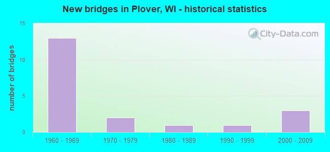
- New bridges - historical statistics
- 131960-1969
- 21970-1979
- 11980-1989
- 11990-1999
- 32000-2009


- Bridge Condition - Deck
- 23.1%Good
- 46.2%Satisfactory
- 7.7%Fair
- 23.1%Poor

- Bridge Condition - Superstructure
- 7.7%Very good
- 23.1%Good
- 53.8%Satisfactory
- 7.7%Fair
- 7.7%Poor

- Bridge Condition - Substructure
- 23.1%Very good
- 7.7%Good
- 46.2%Satisfactory
- 23.1%Fair

- Bridge Condition - Channel
- 85.7%Very good
- 14.3%Satisfactory
Find on map >> Show street view
Structure Number: B49001, Location: 5.5M N JCT CTH W (Lat: 44.388708, Lng: -89.519369), Route carried "on" structure: Interstate 39, Year Built: 1962, Status: Open, Structure Length: 0.73m (2.40ft), Average Daily Traffic: 15,900 (year 2019), Truck Traffic: 14%, Average Future Daily Traffic: 20,600 (year 2037), Design Load: HS 20, Features Intersected: BUENA VISTA CREEK
Minimum Vertical Clearance: 30+ m (98+ ft), Kilometerpoint: 0.000, Lanes on structure: 2, Base Highway Network: Yes, Owner: State Highway Agency, Approaching Roadway Width: 13.4m (44.0ft), Material/Design: Concrete, Design/Construction: Slab, Number Of Spans In Main Unit: 1, Length of Maximum Span: 7.0m (23.0ft), Curb-To-Curb Width: 13.4m (44.0ft), Out-to-Out Width: 14.2m (46.6ft)
Condition: Deck: Satisfactory, Superstructure: Satisfactory, Substructure: Satisfactory, Channel: Very good, Operating Rating: 35.9 metric tons, Method Used To Determine Operating Rating: Load Factor (LF), Inventory Rating: 21.1 metric tons, Method Used To Determine Inventory Rating: Load Factor (LF), Structural Evaluation: Somewhat better than minimum adequacy, Deck Geometry: Superior to present desirable criteria, Waterway Adequacy: Equal to present desirable criteria, Approach Roadway Alignment: Equal to present desirable criteria, Bridge Posting: Required (Relationship of Operating Rating to Maximum Legal Load: 0.1 - 9.9% below), Designated Inspection Frequency: Every 24 months, Inspection Date: June 2020, Deck Structure Type: Concrete Cast-file-Place, Wearing Surface/Protective System: Wearing Surface: Epoxy Overlay
Find on map >> Show street view
Structure Number: B490013, Location: 0.2M N JCT USH 51 (Lat: 44.430794, Lng: -89.519031), Route carried "on" structure: Business US 51, Year Built: 1969, Status: Open, Structure Length: 8.01m (26.28ft), Average Daily Traffic: 6,000 (year 2019), Truck Traffic: 5%, Average Future Daily Traffic: 8,370 (year 2039), Design Load: HS 20, Features Intersected: IH USH 51-IH 39
Minimum Vertical Clearance: 30+ m (98+ ft), Kilometerpoint: 0.000, Lanes on structure: 2, Lanes under structure: 4, Owner: State Highway Agency, Approaching Roadway Width: 13.4m (44.0ft), Skew: 4 degrees, Material/Design: Steel continuous, Design/Construction: Stringer/Multi-beam, Number Of Spans In Main Unit: 2, Length of Maximum Span: 40.2m (131.9ft), Curb-To-Curb Width: 13.4m (44.0ft), Out-to-Out Width: 14.3m (46.9ft)
Condition: Deck: Satisfactory, Superstructure: Satisfactory, Substructure: Satisfactory, Operating Rating: 47.4 metric tons, Method Used To Determine Operating Rating: Load Factor (LF), Inventory Rating: 27.5 metric tons, Method Used To Determine Inventory Rating: Load Factor (LF), Structural Evaluation: Equal to present minimum criteria, Deck Geometry: Equal to present minimum criteria, Underclear: Somewhat better than minimum adequacy, Approach Roadway Alignment: Equal to present desirable criteria, Designated Inspection Frequency: Every 24 months, Inspection Date: June 2020, Deck Structure Type: Concrete Cast-file-Place, Wearing Surface/Protective System: Wearing Surface: Low Slump Concrete
Find on map >> Show street view
Structure Number: B490014, Location: 1.8M N JCT STH 54 TO E (Lat: 44.453667, Lng: -89.518142), Route carried "on" structure: Interstate 39, Year Built: 1969, Status: Open, Structure Length: 5.00m (16.40ft), Average Daily Traffic: 21,500 (year 2020), Truck Traffic: 15%, Average Future Daily Traffic: 18,400 (year 2040), Design Load: HS 20, Features Intersected: CTH B
Minimum Vertical Clearance: 30+ m (98+ ft), Kilometerpoint: 0.000, Lanes on structure: 2, Lanes under structure: 4, Base Highway Network: Yes, Owner: State Highway Agency, Approaching Roadway Width: 12.2m (40.0ft), Material/Design: Prestressed concrete continuous, Design/Construction: Stringer/Multi-beam, Number Of Spans In Main Unit: 2, Length of Maximum Span: 25.5m (83.7ft), Curb-To-Curb Width: 11.9m (39.0ft), Out-to-Out Width: 12.8m (42.0ft)
Condition: Deck: Fair, Superstructure: Poor, Substructure: Fair, Operating Rating: 62.1 metric tons, Method Used To Determine Operating Rating: Load Factor (LF), Inventory Rating: 29.2 metric tons, Method Used To Determine Inventory Rating: Load Factor (LF), Structural Evaluation: Meets minimum limits, Deck Geometry: Equal to present minimum criteria, Underclear: Equal to present minimum criteria, Approach Roadway Alignment: Equal to present desirable criteria, Length Of Structure Improvement: 5.46m (17.91ft), Designated Inspection Frequency: Every 24 months, Inspection Date: August 2021, Bridge Improvement Cost: $676,000, Roadway Improvement Cost: $67,000, Total Project Cost: $1,014,000 ( Estimate for 2021), Deck Structure Type: Concrete Cast-file-Place, Wearing Surface/Protective System: Wearing Surface: Low Slump Concrete
Find on map >> Show street view
Structure Number: B490015, Location: 4.8M S JCT USH 10 TO E (Lat: 44.454125, Lng: -89.518631), Route carried "on" structure: Interstate 39, Year Built: 1969, Status: Open, Structure Length: 5.00m (16.40ft), Average Daily Traffic: 21,500 (year 2020), Truck Traffic: 15%, Average Future Daily Traffic: 18,400 (year 2040), Design Load: HS 20, Features Intersected: CTH B
Minimum Vertical Clearance: 30+ m (98+ ft), Kilometerpoint: 0.000, Lanes on structure: 2, Lanes under structure: 4, Base Highway Network: Yes, Owner: State Highway Agency, Approaching Roadway Width: 12.2m (40.0ft), Material/Design: Prestressed concrete continuous, Design/Construction: Stringer/Multi-beam, Number Of Spans In Main Unit: 2, Length of Maximum Span: 25.5m (83.7ft), Curb-To-Curb Width: 11.9m (39.0ft), Out-to-Out Width: 12.8m (42.0ft)
Condition: Deck: Poor, Superstructure: Fair, Substructure: Fair, Operating Rating: 62.1 metric tons, Method Used To Determine Operating Rating: Load Factor (LF), Inventory Rating: 29.2 metric tons, Method Used To Determine Inventory Rating: Load Factor (LF), Structural Evaluation: Somewhat better than minimum adequacy, Deck Geometry: Equal to present minimum criteria, Underclear: Equal to present minimum criteria, Approach Roadway Alignment: Equal to present desirable criteria, Length Of Structure Improvement: 5.46m (17.91ft), Designated Inspection Frequency: Every 12 months, Inspection Date: August 2021, Bridge Improvement Cost: $676,000, Roadway Improvement Cost: $67,000, Total Project Cost: $1,014,000 ( Estimate for 2021), Deck Structure Type: Concrete Cast-file-Place, Wearing Surface/Protective System: Wearing Surface: Low Slump Concrete
Find on map >> Show street view
Structure Number: B490016, Location: 2.0M N JCT STH 54 TO E (Lat: 44.456839, Lng: -89.518100), Route carried "on" structure: Interstate 39, Year Built: 1969, Status: Open, Structure Length: 4.85m (15.91ft), Average Daily Traffic: 24,700 (year 2019), Truck Traffic: 16%, Average Future Daily Traffic: 28,837 (year 2039), Design Load: HS 20, Features Intersected: FV&W RR
Minimum Vertical Clearance: 30+ m (98+ ft), Kilometerpoint: 0.000, Lanes on structure: 3, Base Highway Network: Yes, Owner: State Highway Agency, Approaching Roadway Width: 14.3m (46.9ft), Material/Design: Prestressed concrete continuous, Design/Construction: Stringer/Multi-beam, Number Of Spans In Main Unit: 3, Length of Maximum Span: 18.2m (59.7ft), Curb-To-Curb Width: 14.4m (47.2ft), Out-to-Out Width: 15.3m (50.2ft)
Condition: Deck: Poor, Superstructure: Good, Substructure: Fair, Operating Rating: 55.5 metric tons, Method Used To Determine Operating Rating: Load Factor (LF), Inventory Rating: 34.0 metric tons, Method Used To Determine Inventory Rating: Load Factor (LF), Structural Evaluation: Somewhat better than minimum adequacy, Deck Geometry: Meets minimum limits, Underclear: Meets minimum limits, Approach Roadway Alignment: Equal to present desirable criteria, Length Of Structure Improvement: 5.30m (17.39ft), Designated Inspection Frequency: Every 24 months, Inspection Date: July 2020, Bridge Improvement Cost: $658,000, Roadway Improvement Cost: $65,000, Total Project Cost: $987,000 ( Estimate for 2021), Deck Structure Type: Concrete Cast-file-Place, Wearing Surface/Protective System: Wearing Surface: Low Slump Concrete
Find on map >> Show street view
Structure Number: B490017, Location: 4.6M S JCT USH 10 TO E (Lat: 44.457286, Lng: -89.518628), Route carried "on" structure: Interstate 39, Year Built: 1969, Status: Open, Structure Length: 4.65m (15.26ft), Average Daily Traffic: 15,800 (year 2019), Truck Traffic: 15%, Average Future Daily Traffic: 18,400 (year 2039), Design Load: HS 20, Features Intersected: FV&W RR
Minimum Vertical Clearance: 30+ m (98+ ft), Kilometerpoint: 0.000, Lanes on structure: 2, Base Highway Network: Yes, Owner: State Highway Agency, Approaching Roadway Width: 12.2m (40.0ft), Material/Design: Prestressed concrete continuous, Design/Construction: Stringer/Multi-beam, Number Of Spans In Main Unit: 3, Length of Maximum Span: 16.2m (53.1ft), Curb-To-Curb Width: 12.1m (39.7ft), Out-to-Out Width: 13.0m (42.7ft)
Condition: Deck: Poor, Superstructure: Satisfactory, Substructure: Satisfactory, Operating Rating: 53.9 metric tons, Method Used To Determine Operating Rating: Load Factor (LF), Inventory Rating: 30.8 metric tons, Method Used To Determine Inventory Rating: Load Factor (LF), Structural Evaluation: Equal to present minimum criteria, Deck Geometry: Equal to present minimum criteria, Underclear: Meets minimum limits, Approach Roadway Alignment: Equal to present desirable criteria, Length Of Structure Improvement: 5.09m (16.70ft), Designated Inspection Frequency: Every 24 months, Inspection Date: July 2020, Bridge Improvement Cost: $633,000, Roadway Improvement Cost: $63,000, Total Project Cost: $949,000 ( Estimate for 2021), Deck Structure Type: Concrete Cast-file-Place, Wearing Surface/Protective System: Wearing Surface: Low Slump Concrete
Find on map >> Show street view
Structure Number: B490018, Location: 3.0M N JCT STH 54 TO E (Lat: 44.471864, Lng: -89.518139), Route carried "on" structure: Interstate 39, Year Built: 1969, Status: Open, Structure Length: 1.93m (6.33ft), Average Daily Traffic: 24,700 (year 2019), Truck Traffic: 15%, Average Future Daily Traffic: 18,400 (year 2039), Design Load: HS 20, Features Intersected: LITTLE PLOVER RIVER
Minimum Vertical Clearance: 30+ m (98+ ft), Kilometerpoint: 0.000, Lanes on structure: 2, Base Highway Network: Yes, Owner: State Highway Agency, Approaching Roadway Width: 11.6m (38.1ft), Skew: 2 degrees, Material/Design: Concrete continuous, Design/Construction: Slab, Number Of Spans In Main Unit: 2, Length of Maximum Span: 9.6m (31.5ft), Curb-To-Curb Width: 11.9m (39.0ft), Out-to-Out Width: 12.8m (42.0ft)
Condition: Deck: Satisfactory, Superstructure: Satisfactory, Substructure: Satisfactory, Channel: Very good, Operating Rating: 50.6 metric tons, Method Used To Determine Operating Rating: Load Factor (LF), Inventory Rating: 29.2 metric tons, Method Used To Determine Inventory Rating: Load Factor (LF), Structural Evaluation: Equal to present minimum criteria, Deck Geometry: Equal to present minimum criteria, Waterway Adequacy: Equal to present desirable criteria, Approach Roadway Alignment: Equal to present desirable criteria, Designated Inspection Frequency: Every 24 months, Inspection Date: July 2020, Deck Structure Type: Concrete Cast-file-Place, Wearing Surface/Protective System: Wearing Surface: Epoxy Overlay
Find on map >> Show street view
Structure Number: B490019, Location: 3.6M S JCT USH 10 TO E (Lat: 44.472197, Lng: -89.518625), Route carried "on" structure: Interstate 39, Year Built: 1969, Status: Open, Structure Length: 1.93m (6.33ft), Average Daily Traffic: 24,700 (year 2019), Truck Traffic: 15%, Average Future Daily Traffic: 18,400 (year 2039), Design Load: HS 20, Features Intersected: LITTLE PLOVER RIVER
Minimum Vertical Clearance: 30+ m (98+ ft), Kilometerpoint: 0.000, Lanes on structure: 2, Base Highway Network: Yes, Owner: State Highway Agency, Approaching Roadway Width: 11.6m (38.1ft), Skew: 2 degrees, Material/Design: Concrete continuous, Design/Construction: Slab, Number Of Spans In Main Unit: 2, Length of Maximum Span: 9.6m (31.5ft), Curb-To-Curb Width: 11.9m (39.0ft), Out-to-Out Width: 12.8m (42.0ft)
Condition: Deck: Satisfactory, Superstructure: Satisfactory, Substructure: Satisfactory, Channel: Very good, Operating Rating: 50.6 metric tons, Method Used To Determine Operating Rating: Load Factor (LF), Inventory Rating: 29.2 metric tons, Method Used To Determine Inventory Rating: Load Factor (LF), Structural Evaluation: Equal to present minimum criteria, Deck Geometry: Equal to present minimum criteria, Waterway Adequacy: Equal to present desirable criteria, Approach Roadway Alignment: Equal to present desirable criteria, Designated Inspection Frequency: Every 24 months, Inspection Date: July 2020, Deck Structure Type: Concrete Cast-file-Place, Wearing Surface/Protective System: Wearing Surface: Epoxy Overlay
Find on map >> Show street view
Structure Number: B490034, Location: 0.7M N JCT STH 54 TO E (Lat: 44.437858, Lng: -89.518242), Route carried "on" structure: Interstate 39, Year Built: 1969, Status: Open, Structure Length: 1.32m (4.33ft), Average Daily Traffic: 15,800 (year 2019), Truck Traffic: 18%, Average Future Daily Traffic: 34,350 (year 2039), Design Load: HS 20, Features Intersected: BR WISCONSIN RIVER
Minimum Vertical Clearance: 30+ m (98+ ft), Kilometerpoint: 0.000, Lanes on structure: 4, Base Highway Network: Yes, Owner: State Highway Agency, Approaching Roadway Width: 12.2m (40.0ft), Material/Design: Concrete continuous, Design/Construction: Culvert, Number Of Spans In Main Unit: 4, Length of Maximum Span: 3.0m (9.8ft)
Condition: Channel: Very good, Culverts: Satisfactory, Operating Rating: 53.9 metric tons, Method Used To Determine Operating Rating: Field evaluation and documented engineering judgment, Inventory Rating: 32.4 metric tons, Method Used To Determine Inventory Rating: Field evaluation and documented engineering judgment, Structural Evaluation: Equal to present minimum criteria, Waterway Adequacy: Equal to present desirable criteria, Approach Roadway Alignment: Equal to present desirable criteria, Designated Inspection Frequency: Every 24 months, Inspection Date: June 2020, Deck Structure Type: Concrete Cast-file-Place, Wearing Surface/Protective System: Wearing Surface: Monolithic Concrete
Find on map >> Show street view
Structure Number: B490049, Location: 3.2M S JCT STH 54 TO E (Lat: 44.388764, Lng: -89.519869), Route carried "on" structure: Interstate 39, Year Built: 1978, Status: Open, Structure Length: 0.74m (2.43ft), Average Daily Traffic: 15,900 (year 2019), Truck Traffic: 14%, Average Future Daily Traffic: 20,600 (year 2037), Design Load: HS 20, Features Intersected: BUENA VISTA CREEK
Minimum Vertical Clearance: 30+ m (98+ ft), Kilometerpoint: 0.000, Lanes on structure: 2, Base Highway Network: Yes, Owner: State Highway Agency, Approaching Roadway Width: 12.2m (40.0ft), Material/Design: Concrete, Design/Construction: Slab, Number Of Spans In Main Unit: 1, Length of Maximum Span: 7.0m (23.0ft), Curb-To-Curb Width: 12.2m (40.0ft), Out-to-Out Width: 12.7m (41.7ft)
Condition: Deck: Satisfactory, Superstructure: Satisfactory, Substructure: Satisfactory, Channel: Very good, Operating Rating: 52.3 metric tons, Method Used To Determine Operating Rating: Load Factor (LF), Inventory Rating: 29.2 metric tons, Method Used To Determine Inventory Rating: Load Factor (LF), Structural Evaluation: Equal to present minimum criteria, Deck Geometry: Better than present minimum criteria, Waterway Adequacy: Equal to present desirable criteria, Approach Roadway Alignment: Equal to present desirable criteria, Designated Inspection Frequency: Every 24 months, Inspection Date: June 2020, Deck Structure Type: Concrete Cast-file-Place, Wearing Surface/Protective System: Wearing Surface: Epoxy Overlay
Find on map >> Show street view
Structure Number: B490097, Location: 1.0M S JCT STH 10 (Lat: 44.512064, Lng: -89.508947), Route carried "on" structure: City street , Year Built: 1999, Status: Open, Structure Length: 4.70m (15.42ft), Average Daily Traffic: 2,836 (year 2019), Average Future Daily Traffic: 3,119 (year 2035), Design Load: HS 20, Features Intersected: CN RR, Facility Carried by Structure: LRD COUNTY ROAD R
Minimum Vertical Clearance: 30+ m (98+ ft), Kilometerpoint: 0.000, Lanes on structure: 4, Owner: County Highway Agency, Approaching Roadway Width: 17.4m (57.1ft), Material/Design: Prestressed concrete continuous, Design/Construction: Stringer/Multi-beam, Number Of Spans In Main Unit: 3, Length of Maximum Span: 17.4m (57.1ft), Curb-To-Curb Width: 18.3m (60.0ft), Out-to-Out Width: 21.9m (71.9ft)
Condition: Deck: Good, Superstructure: Very good, Substructure: Very good, Operating Rating: 58.8 metric tons, Method Used To Determine Operating Rating: Load Factor (LF), Inventory Rating: 37.3 metric tons, Method Used To Determine Inventory Rating: Load Factor (LF), Structural Evaluation: Equal to present desirable criteria, Deck Geometry: Somewhat better than minimum adequacy, Underclear: Equal to present minimum criteria, Approach Roadway Alignment: Equal to present desirable criteria, Designated Inspection Frequency: Every 48 months, Inspection Date: August 2019, Deck Structure Type: Concrete Cast-file-Place, Wearing Surface/Protective System: Wearing Surface: Epoxy Overlay, Deck Protection: Epoxy Coated Reinforcing
Find on map >> Show street view
Structure Number: B490134, Location: 0.05 M W JCT EISENHOWER D (Lat: 44.470500, Lng: -89.510056), Route carried "on" structure: City street , Year Built: 2003, Status: Open, Structure Length: 0.93m (3.05ft), Average Daily Traffic: 106 (year 2019), Average Future Daily Traffic: 116 (year 2039), Design Load: HS 20, Features Intersected: LITTLE PLOVER R, Facility Carried by Structure: LRD BLUEBIRD LN
Minimum Vertical Clearance: 30+ m (98+ ft), Kilometerpoint: 0.000, Lanes on structure: 2, Owner: Town or Township Highway Agency, Approaching Roadway Width: 7.9m (25.9ft), Material/Design: Concrete, Design/Construction: Slab, Number Of Spans In Main Unit: 1, Length of Maximum Span: 8.5m (27.9ft), Curb-To-Curb Width: 7.3m (24.0ft), Out-to-Out Width: 7.9m (25.9ft)
Condition: Deck: Good, Superstructure: Good, Substructure: Very good, Channel: Satisfactory, Operating Rating: 68.6 metric tons, Method Used To Determine Operating Rating: Load Factor (LF), Inventory Rating: 40.5 metric tons, Method Used To Determine Inventory Rating: Load Factor (LF), Structural Evaluation: Better than present minimum criteria, Deck Geometry: Somewhat better than minimum adequacy, Waterway Adequacy: Better than present minimum criteria, Approach Roadway Alignment: Equal to present desirable criteria, Designated Inspection Frequency: Every 24 months, Inspection Date: September 2020, Wearing Surface/Protective System: Wearing Surface: Monolithic Concrete, Deck Protection: Epoxy Coated Reinforcing
Find on map >> Show street view
Structure Number: B490167, Location: 2.7 M NORTH CTH B (Lat: 44.483000, Lng: -89.518917), Route carried "on" structure: City street , Year Built: 2009, Status: Open, Structure Length: 7.13m (23.39ft), Average Daily Traffic: 5,700 (year 2019), Truck Traffic: 3%, Average Future Daily Traffic: 8,000 (year 2039), Design Load: HL 93, Features Intersected: IH39N-USH51NB, Facility Carried by Structure: LRD PORTER ROAD
Minimum Vertical Clearance: 30+ m (98+ ft), Kilometerpoint: 0.000, Lanes on structure: 2, Lanes under structure: 4, Owner: State Highway Agency, Approaching Roadway Width: 12.2m (40.0ft), Material/Design: Prestressed concrete continuous, Design/Construction: Stringer/Multi-beam, Number Of Spans In Main Unit: 2, Length of Maximum Span: 35.1m (115.2ft), Curb-To-Curb Width: 12.2m (40.0ft), Out-to-Out Width: 12.8m (42.0ft)
Condition: Deck: Good, Superstructure: Good, Substructure: Very good, Operating Rating: 47.0 metric tons, Method Used To Determine Operating Rating: Load and Resistance Factor Rating (LRFR) rating reported by rating factor(RF) method using HL-93 loadings, Inventory Rating: 36.3 metric tons, Method Used To Determine Inventory Rating: Load and Resistance Factor Rating (LRFR) rating reported by rating factor(RF) method using HL-93 loadings, Structural Evaluation: Better than present minimum criteria, Deck Geometry: Somewhat better than minimum adequacy, Underclear: Better than present minimum criteria, Approach Roadway Alignment: Equal to present desirable criteria, Designated Inspection Frequency: Every 48 months, Inspection Date: July 2020, Deck Structure Type: Concrete Cast-file-Place, Wearing Surface/Protective System: Wearing Surface: Monolithic Concrete, Deck Protection: Epoxy Coated Reinforcing
Find on map >> Show street view
Structure Number: P490071, Location: 3.6M N JCT CTH W (Lat: 44.388586, Lng: -89.548844), Route carried "on" structure: City street , Year Built: 1981, Status: Open, Structure Length: 0.79m (2.59ft), Average Daily Traffic: 208 (year 2019), Average Future Daily Traffic: 228 (year 2039), Design Load: HS 20, Features Intersected: BUENA VISTA CREEK, Facility Carried by Structure: LRD TAFT AVE
Minimum Vertical Clearance: 30+ m (98+ ft), Kilometerpoint: 0.000, Lanes on structure: 2, Owner: Town or Township Highway Agency, Approaching Roadway Width: 9.8m (32.2ft), Material/Design: Concrete, Design/Construction: Slab, Number Of Spans In Main Unit: 1, Length of Maximum Span: 7.5m (24.6ft), Curb-To-Curb Width: 7.9m (25.9ft), Out-to-Out Width: 8.5m (27.9ft)
Condition: Deck: Satisfactory, Superstructure: Satisfactory, Substructure: Good, Channel: Very good, Operating Rating: 58.8 metric tons, Method Used To Determine Operating Rating: Load Factor (LF), Inventory Rating: 34.0 metric tons, Method Used To Determine Inventory Rating: Load Factor (LF), Structural Evaluation: Equal to present minimum criteria, Deck Geometry: Somewhat better than minimum adequacy, Waterway Adequacy: Equal to present desirable criteria, Approach Roadway Alignment: Equal to present desirable criteria, Designated Inspection Frequency: Every 24 months, Inspection Date: September 2020, Deck Structure Type: Concrete Cast-file-Place, Wearing Surface/Protective System: Wearing Surface: Monolithic Concrete
Find on map >> Show street view
Structure Number: B490013, Location: 8.3M N JCT CTH W (Lat: 44.430794, Lng: -89.519031), Route carried "under" structure: Interstate 39, Year Built: 1969, Structure Length: 0. m, Average Daily Traffic: 13,900 (year 2019), Truck Traffic: 18%, Features Intersected: IH USH 51-IH 39, Facility Carried by Structure: USH STH 54-USH B51
Minimum Vertical Clearance: 4.91m (16.11ft), Kilometerpoint: 0.000, Lanes on structure: 2, Lanes under structure: 4, Material/Design: Steel continuous, Design/Construction: Stringer/Multi-beam, Length of Maximum Span: 40.2m (131.9ft)
Find on map >> Show street view
Structure Number: B490014, Location: 1.2M E JCT STH 54 (Lat: 44.453667, Lng: -89.518142), Route carried "under" structure: County highway , Year Built: 1969, Structure Length: 0. m, Average Daily Traffic: 20,000 (year 2019), Features Intersected: CTH B, Facility Carried by Structure: IH USH51-IH39NB
Minimum Vertical Clearance: 4.53m (14.86ft), Kilometerpoint: 0.000, Lanes on structure: 2, Lanes under structure: 4, Material/Design: Prestressed concrete continuous, Design/Construction: Stringer/Multi-beam, Length of Maximum Span: 25.5m (83.7ft)
Find on map >> Show street view
Structure Number: B490015, Location: 1.2M E JCT STH 54 (Lat: 44.454125, Lng: -89.518631), Route carried "under" structure: County highway , Year Built: 1969, Structure Length: 0. m, Average Daily Traffic: 12,600 (year 2020), Features Intersected: CTH B, Facility Carried by Structure: IH USH51-IH39SB
Minimum Vertical Clearance: 4.56m (14.96ft), Kilometerpoint: 0.000, Lanes on structure: 2, Lanes under structure: 4, Material/Design: Prestressed concrete continuous, Design/Construction: Stringer/Multi-beam, Length of Maximum Span: 25.5m (83.7ft)
Find on map >> Show street view
Structure Number: B490021, Location: 4.8M N JCT STH 54 TO E (Lat: 44.497192, Lng: -89.518700), Route carried "under" structure: Interstate 39, Year Built: 1969, Structure Length: 0. m, Average Daily Traffic: 24,700 (year 2019), Truck Traffic: 15%, Features Intersected: IH USH 51-IH 39, Facility Carried by Structure: CTH HH
Minimum Vertical Clearance: 4.90m (16.08ft), Kilometerpoint: 0.000, Lanes on structure: 5, Lanes under structure: 4, Material/Design: Steel continuous, Design/Construction: Stringer/Multi-beam, Length of Maximum Span: 27.6m (90.6ft)
Find on map >> Show street view
Structure Number: B49005, Location: 7.3M N JCT CTH W (Lat: 44.410394, Lng: -89.519519), Route carried "under" structure: Interstate 39, Year Built: 1978, Structure Length: 0. m, Average Daily Traffic: 15,800 (year 2019), Truck Traffic: 14%, Features Intersected: IH USH 51-IH 39, Facility Carried by Structure: LRD BIRCH DR
Minimum Vertical Clearance: 4.98m (16.34ft), Kilometerpoint: 0.000, Lanes on structure: 2, Lanes under structure: 4, Material/Design: Steel continuous, Design/Construction: Stringer/Multi-beam, Length of Maximum Span: 33.8m (110.9ft)
Find on map >> Show street view
Structure Number: B490167, Location: AT PORTER ROA (Lat: 44.483000, Lng: -89.518917), Route carried "under" structure: Interstate 39, Year Built: 2009, Structure Length: 0. m, Average Daily Traffic: 24,800 (year 2019), Truck Traffic: 8%, Features Intersected: IH39N-USH51NB, Facility Carried by Structure: LRD PORTER ROAD
Minimum Vertical Clearance: 5.36m (17.59ft), Kilometerpoint: 0.000, Lanes on structure: 2, Lanes under structure: 4, Material/Design: Prestressed concrete continuous, Design/Construction: Stringer/Multi-beam, Length of Maximum Span: 35.1m (115.2ft)