Bridge Statistics for Palatka, Florida (FL)
Condition, Traffic, Stress, Structural Evaluation, Project Costs
- National Bridge Inventory (NBI) Statistics
- 15Number of bridges
- 1,417ft / 432mTotal length
- $1,080,000Total costs
- 111,581Total average daily traffic
- 10,810Total average daily truck traffic
- National Bridge Inventory (NBI) Registered Bridges for Palatka
- No street view available for this location
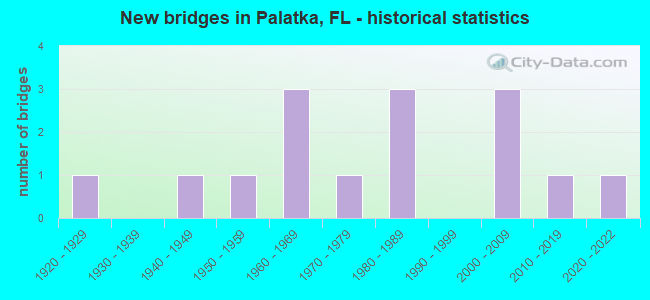
- New bridges - historical statistics
- 11920-1929
- 11940-1949
- 11950-1959
- 31960-1969
- 11970-1979
- 31980-1989
- 32000-2009
- 12010-2019
- 12020-2022
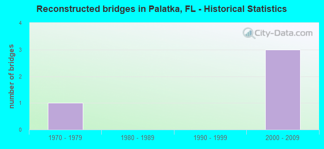
- Reconstructed bridges - Historical Statistics
- 11970-1979
- 01980-1989
- 01990-1999
- 32000-2009
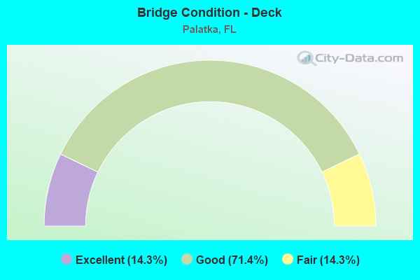
- Bridge Condition - Deck
- 14.3%Excellent
- 71.4%Good
- 14.3%Fair
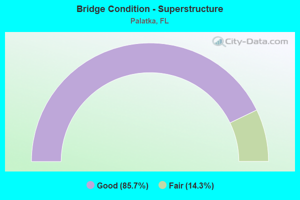
- Bridge Condition - Superstructure
- 85.7%Good
- 14.3%Fair
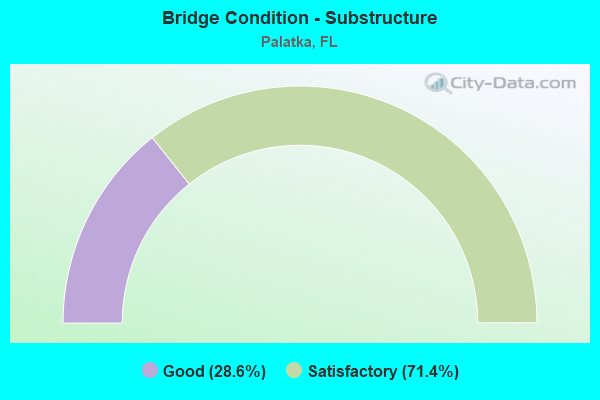
- Bridge Condition - Substructure
- 28.6%Good
- 71.4%Satisfactory
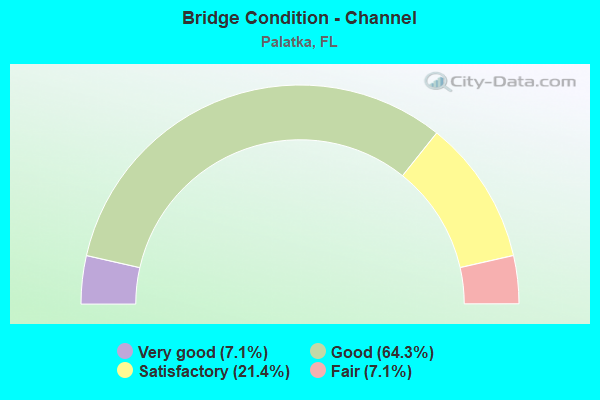
- Bridge Condition - Channel
- 7.1%Very good
- 64.3%Good
- 21.4%Satisfactory
- 7.1%Fair
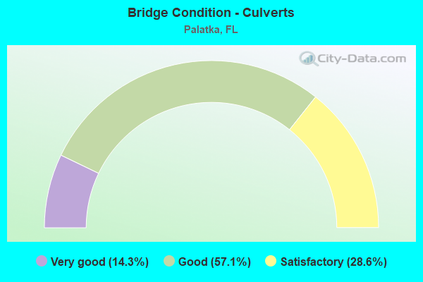
- Bridge Condition - Culverts
- 14.3%Very good
- 57.1%Good
- 28.6%Satisfactory
Find on map >> Show street view
Structure Number: 760029, Location: 1.86 MI. W. OF CR-309 (Lat: 29.688172, Lng: -81.741969), Route carried "on" structure: State highway 100, Year Built: 1963, Status: Open, Structure Length: 9.14m (29.99ft), Average Daily Traffic: 7,200 (year 2020), Truck Traffic: 14%, Average Future Daily Traffic: 12,492 (year 2042), Design Load: H 20, Features Intersected: RICE CREEK
Minimum Vertical Clearance: 30+ m (98+ ft), Kilometerpoint: 25.210, Lanes on structure: 2, Base Highway Network: Yes, Owner: State Highway Agency, Approaching Roadway Width: 10.4m (34.1ft), Material/Design: Concrete, Design/Construction: Slab, Number Of Spans In Main Unit: 12, Length of Maximum Span: 7.6m (24.9ft), Curb-To-Curb Width: 8.6m (28.2ft), Out-to-Out Width: 10.4m (34.1ft)
Condition: Deck: Good, Superstructure: Good, Substructure: Satisfactory, Channel: Satisfactory, Operating Rating: 50.2 metric tons, Method Used To Determine Operating Rating: Load Factor (LF), Inventory Rating: 30.1 metric tons, Method Used To Determine Inventory Rating: Load Factor (LF), Structural Evaluation: Equal to present minimum criteria, Deck Geometry: Meets minimum limits, Waterway Adequacy: Equal to present desirable criteria, Approach Roadway Alignment: Equal to present desirable criteria, Designated Inspection Frequency: Every 24 months, Inspection Date: July 2020, Deck Structure Type: Concrete Cast-file-Place, Wearing Surface/Protective System: Wearing Surface: Bituminous
Find on map >> Show street view
Structure Number: 760043, Location: PALATKA 0.7 MI S OF SR 20 (Lat: 29.645989, Lng: -81.622856), Route carried "on" structure: US 17, Year Built: 1977, Year Reconstructed: 2013, Status: Open, Structure Length: 122.55m (402.07ft), Average Daily Traffic: 31,000 (year 2020), Truck Traffic: 8%, Average Future Daily Traffic: 53,785 (year 2042), Design Load: HS 20, Features Intersected: ST JOHNS RIVER
Minimum Vertical Clearance: 30+ m (98+ ft), Kilometerpoint: 44.803, Lanes on structure: 4, Base Highway Network: Yes, Owner: State Highway Agency, Approaching Roadway Width: 20.6m (67.6ft), Skew: 30 degrees, Navigation Control: Yes ( Vertical Clearance: 0.3m (1.0ft), Horizontal Clearance: 0.3m (1.0ft)), Material/Design: Steel continuous, Design/Construction: Stringer/Multi-beam, Number Of Spans In Main Unit: 3, Number Of Approach Spans: 45, Length of Maximum Span: 60.4m (198.2ft), Curb or Sidewalk Widths: Left: 1.5m (4.9ft), Right: 2.4m (7.9ft), Curb-To-Curb Width: 22.3m (73.2ft), Out-to-Out Width: 28.3m (92.8ft)
Condition: Deck: Good, Superstructure: Good, Substructure: Satisfactory, Channel: Good, Operating Rating: 53.5 metric tons, Method Used To Determine Operating Rating: Load Factor (LF), Inventory Rating: 40.8 metric tons, Method Used To Determine Inventory Rating: Load Factor (LF), Structural Evaluation: Equal to present minimum criteria, Deck Geometry: Superior to present desirable criteria, Waterway Adequacy: Equal to present desirable criteria, Approach Roadway Alignment: Equal to present desirable criteria, Length Of Structure Improvement: 122.56m (402.10ft), Designated Inspection Frequency: Every 24 months, Underwater Inspection Frequency: Every 23 months, Inspection Date: August 2021, Underwater Inspection Date: August 2021, Bridge Improvement Cost: $508,000, Total Project Cost: $705,000, Deck Structure Type: Concrete Cast-file-Place
Find on map >> Show street view
Structure Number: 760044, Location: 2.3 MI. N. OF PALATKA (Lat: 29.698900, Lng: -81.663803), Route carried "on" structure: US 17, Year Built: 1981, Status: Open, Structure Length: 59.74m (196.00ft), Average Daily Traffic: 6,800 (year 2020), Truck Traffic: 14%, Average Future Daily Traffic: 11,798 (year 2042), Design Load: HS 20, Features Intersected: RICE CREEK
Minimum Vertical Clearance: 30+ m (98+ ft), Kilometerpoint: 4.860, Lanes on structure: 2, Base Highway Network: Yes, Owner: State Highway Agency, Approaching Roadway Width: 9.1m (29.9ft), Navigation Control: Yes ( Vertical Clearance: 14.1m (46.3ft), Horizontal Clearance: 22.6m (74.1ft)), Material/Design: Prestressed concrete, Design/Construction: Stringer/Multi-beam, Number Of Spans In Main Unit: 21, Length of Maximum Span: 33.5m (109.9ft), Curb-To-Curb Width: 12.2m (40.0ft), Out-to-Out Width: 13.0m (42.7ft)
Condition: Deck: Good, Superstructure: Good, Substructure: Satisfactory, Channel: Good, Operating Rating: 62.1 metric tons, Method Used To Determine Operating Rating: Load and Resistance Factor (LRFR), Inventory Rating: 22.2 metric tons, Method Used To Determine Inventory Rating: Load and Resistance Factor (LRFR), Structural Evaluation: Somewhat better than minimum adequacy, Deck Geometry: Better than present minimum criteria, Waterway Adequacy: Equal to present desirable criteria, Approach Roadway Alignment: Equal to present desirable criteria, Designated Inspection Frequency: Every 24 months, Underwater Inspection Frequency: Every 23 months, Inspection Date: November 2021, Underwater Inspection Date: November 2021, Total Project Cost: $250,000, Deck Structure Type: Concrete Cast-file-Place
Find on map >> Show street view
Structure Number: 760045, Location: 2.3 MI. N. OF PALATKA (Lat: 29.698889, Lng: -81.663611), Route carried "on" structure: US 17, Year Built: 1981, Status: Open, Structure Length: 59.74m (196.00ft), Average Daily Traffic: 6,800 (year 2020), Truck Traffic: 14%, Average Future Daily Traffic: 11,798 (year 2042), Design Load: HS 20, Features Intersected: RICE CREEK
Minimum Vertical Clearance: 30+ m (98+ ft), Kilometerpoint: 4.860, Lanes on structure: 2, Base Highway Network: Yes, Owner: State Highway Agency, Approaching Roadway Width: 9.6m (31.5ft), Navigation Control: Yes ( Vertical Clearance: 14.1m (46.3ft), Horizontal Clearance: 22.6m (74.1ft)), Material/Design: Prestressed concrete, Design/Construction: Stringer/Multi-beam, Number Of Spans In Main Unit: 21, Length of Maximum Span: 33.5m (109.9ft), Curb-To-Curb Width: 12.2m (40.0ft), Out-to-Out Width: 13.0m (42.7ft)
Condition: Deck: Good, Superstructure: Good, Substructure: Satisfactory, Channel: Good, Operating Rating: 62.1 metric tons, Method Used To Determine Operating Rating: Load and Resistance Factor (LRFR), Inventory Rating: 22.2 metric tons, Method Used To Determine Inventory Rating: Load and Resistance Factor (LRFR), Structural Evaluation: Somewhat better than minimum adequacy, Deck Geometry: Better than present minimum criteria, Waterway Adequacy: Equal to present desirable criteria, Approach Roadway Alignment: Equal to present desirable criteria, Designated Inspection Frequency: Every 24 months, Underwater Inspection Frequency: Every 23 months, Inspection Date: November 2021, Underwater Inspection Date: November 2021, Deck Structure Type: Concrete Cast-file-Place
Find on map >> Show street view
Structure Number: 760046, Location: 8.3 MI. S. OF PALATKA (Lat: 29.577414, Lng: -81.626275), Route carried "on" structure: US 17, Year Built: 1987, Status: Open, Structure Length: 82.27m (269.91ft), Average Daily Traffic: 11,500 (year 2020), Truck Traffic: 8%, Average Future Daily Traffic: 19,952 (year 2042), Design Load: HS 20, Features Intersected: DUNNS CREEK
Minimum Vertical Clearance: 30+ m (98+ ft), Kilometerpoint: 32.300, Lanes on structure: 2, Base Highway Network: Yes, Owner: State Highway Agency, Approaching Roadway Width: 9.6m (31.5ft), Navigation Control: Yes ( Vertical Clearance: 13.8m (45.3ft), Horizontal Clearance: 18.3m (60.0ft)), Material/Design: Prestressed concrete, Design/Construction: Stringer/Multi-beam, Number Of Spans In Main Unit: 30, Length of Maximum Span: 29.0m (95.1ft), Curb-To-Curb Width: 13.4m (44.0ft), Out-to-Out Width: 14.2m (46.6ft)
Condition: Deck: Good, Superstructure: Good, Substructure: Good, Channel: Good, Operating Rating: 63.5 metric tons, Method Used To Determine Operating Rating: Load Factor (LF), Inventory Rating: 48.0 metric tons, Method Used To Determine Inventory Rating: Load Factor (LF), Structural Evaluation: Better than present minimum criteria, Deck Geometry: Superior to present desirable criteria, Waterway Adequacy: Equal to present desirable criteria, Approach Roadway Alignment: Equal to present desirable criteria, Designated Inspection Frequency: Every 24 months, Underwater Inspection Frequency: Every 23 months, Inspection Date: July 2020, Underwater Inspection Date: July 2020, Deck Structure Type: Concrete Cast-file-Place
Find on map >> Show street view
Structure Number: 760062, Location: 0.27 MI. E. OF CR-309-C (Lat: 29.673894, Lng: -81.711072), Route carried "on" structure: State highway 100, Year Built: 2007, Status: Open, Structure Length: 1.14m (3.74ft), Average Daily Traffic: 9,100 (year 2020), Truck Traffic: 14%, Average Future Daily Traffic: 15,788 (year 2042), Design Load: HL 93, Features Intersected: STRIPPER SWAMP
Minimum Vertical Clearance: 30+ m (98+ ft), Kilometerpoint: 28.648, Lanes on structure: 2, Base Highway Network: Yes, Owner: State Highway Agency, Approaching Roadway Width: 10.4m (34.1ft), Material/Design: Concrete, Design/Construction: Culvert, Number Of Spans In Main Unit: 3, Length of Maximum Span: 3.7m (12.1ft)
Condition: Channel: Good, Culverts: Good, Operating Rating: 61.4 metric tons, Method Used To Determine Operating Rating: Load and Resistance Factor (LRFR), Inventory Rating: 47.4 metric tons, Method Used To Determine Inventory Rating: Load and Resistance Factor (LRFR), Structural Evaluation: Better than present minimum criteria, Waterway Adequacy: Equal to present desirable criteria, Approach Roadway Alignment: Equal to present desirable criteria, Designated Inspection Frequency: Every 24 months, Inspection Date: May 2021
Find on map >> Show street view
Structure Number: 760064, Location: 0.1 MI. EAST OF CR-309D (Lat: 29.678617, Lng: -81.721258), Route carried "on" structure: State highway 100, Year Built: 2011, Status: Open, Structure Length: 1.10m (3.61ft), Average Daily Traffic: 9,100 (year 2020), Truck Traffic: 14%, Average Future Daily Traffic: 15,788 (year 2042), Design Load: HL 93, Features Intersected: LITTLE RICE CREEK
Minimum Vertical Clearance: 30+ m (98+ ft), Kilometerpoint: 27.512, Lanes on structure: 2, Owner: State Highway Agency, Approaching Roadway Width: 10.5m (34.4ft), Skew: 2 degrees, Material/Design: Concrete, Design/Construction: Culvert, Number Of Spans In Main Unit: 3, Length of Maximum Span: 3.1m (10.2ft)
Condition: Channel: Good, Culverts: Good, Operating Rating: 52.4 metric tons, Method Used To Determine Operating Rating: Load and Resistance Factor (LRFR), Inventory Rating: 40.5 metric tons, Method Used To Determine Inventory Rating: Load and Resistance Factor (LRFR), Structural Evaluation: Better than present minimum criteria, Waterway Adequacy: Equal to present desirable criteria, Approach Roadway Alignment: Equal to present desirable criteria, Designated Inspection Frequency: Every 24 months, Inspection Date: March 2021
Find on map >> Show street view
Structure Number: 760065, Location: US 17 SB OVER DUNNS CRK (Lat: 29.577044, Lng: -81.627292), Route carried "on" structure: US 17, Year Built: 2020, Status: Open, Structure Length: 85.59m (280.81ft), Average Daily Traffic: 6,250 (year 2019), Truck Traffic: 7%, Average Future Daily Traffic: 10,844 (year 2041), Design Load: HL 93, Features Intersected: DUNNS CREEK
Minimum Vertical Clearance: 30+ m (98+ ft), Kilometerpoint: 32.300, Lanes on structure: 2, Base Highway Network: Yes, Owner: State Highway Agency, Approaching Roadway Width: 12.2m (40.0ft), Navigation Control: Yes ( Vertical Clearance: 13.7m (44.9ft), Horizontal Clearance: 18.3m (60.0ft)), Material/Design: Prestressed concrete, Design/Construction: Stringer/Multi-beam, Number Of Spans In Main Unit: 18, Length of Maximum Span: 47.5m (155.8ft), Curb or Sidewalk Widths: Left: 3.0m (9.8ft), Right: 0.0m, Curb-To-Curb Width: 12.2m (40.0ft), Out-to-Out Width: 16.5m (54.1ft)
Condition: Deck: Excellent, Superstructure: Good, Substructure: Good, Channel: Very good, Operating Rating: 66.0 metric tons, Method Used To Determine Operating Rating: Load and Resistance Factor (LRFR), Inventory Rating: 40.5 metric tons, Method Used To Determine Inventory Rating: Load and Resistance Factor (LRFR), Structural Evaluation: Better than present minimum criteria, Deck Geometry: Better than present minimum criteria, Waterway Adequacy: Equal to present desirable criteria, Approach Roadway Alignment: Equal to present desirable criteria, Designated Inspection Frequency: Every 19 months, Underwater Inspection Frequency: Every 18 months, Inspection Date: December 2020, Underwater Inspection Date: December 2020, Deck Structure Type: Concrete Cast-file-Place
Find on map >> Show street view
Structure Number: 764001, Location: 0.2 MI E OF US 17 (Lat: 29.715556, Lng: -81.653889), Route carried "on" structure: County highway 209, Year Built: 1964, Status: Open, Structure Length: 0.63m (2.07ft), Average Daily Traffic: 2,500 (year 2021), Truck Traffic: 6%, Average Future Daily Traffic: 4,338 (year 2042), Design Load: H 15, Features Intersected: MOCCASIN CREEK
Minimum Vertical Clearance: 30+ m (98+ ft), Kilometerpoint: 0.385, Lanes on structure: 2, Owner: County Highway Agency, Approaching Roadway Width: 6.9m (22.6ft), Material/Design: Concrete, Design/Construction: Culvert, Number Of Spans In Main Unit: 2, Length of Maximum Span: 3.1m (10.2ft)
Condition: Channel: Fair, Culverts: Good, Operating Rating: 38.6 metric tons, Method Used To Determine Operating Rating: Load Factor (LF), Inventory Rating: 23.1 metric tons, Method Used To Determine Inventory Rating: Load Factor (LF), Structural Evaluation: Equal to present minimum criteria, Waterway Adequacy: Better than present minimum criteria, Approach Roadway Alignment: Equal to present desirable criteria, Designated Inspection Frequency: Every 24 months, Inspection Date: Febuary 2021
Find on map >> Show street view
Structure Number: 764005, Location: 1 MI NORTH OF SR 100 (Lat: 29.693333, Lng: -81.723889), Route carried "on" structure: County highway 309D, Year Built: 1966, Status: Posted for load, Structure Length: 7.62m (25.00ft), Average Daily Traffic: 2,500 (year 2021), Truck Traffic: 6%, Average Future Daily Traffic: 4,338 (year 2042), Features Intersected: RICE CREEK
Minimum Vertical Clearance: 30+ m (98+ ft), Kilometerpoint: 7.469, Lanes on structure: 2, Owner: County Highway Agency, Approaching Roadway Width: 6.1m (20.0ft), Material/Design: Prestressed concrete, Design/Construction: Slab, Number Of Spans In Main Unit: 8, Length of Maximum Span: 9.5m (31.2ft), Curb or Sidewalk Widths: Left: 0.5m (1.6ft), Right: 0.5m (1.6ft), Curb-To-Curb Width: 7.3m (24.0ft), Out-to-Out Width: 9.0m (29.5ft)
Condition: Deck: Fair, Superstructure: Fair, Substructure: Satisfactory, Channel: Good, Operating Rating: 22.2 metric tons, Method Used To Determine Operating Rating: Load and Resistance Factor (LRFR), Inventory Rating: 17.0 metric tons, Method Used To Determine Inventory Rating: Load and Resistance Factor (LRFR), Structural Evaluation: Meets minimum limits, Deck Geometry: High priority of replacement, Waterway Adequacy: Better than present minimum criteria, Approach Roadway Alignment: Equal to present desirable criteria, Bridge Posting: Required (Relationship of Operating Rating to Maximum Legal Load: 20.0 - 29.9% below), Designated Inspection Frequency: Every 24 months, Underwater Inspection Frequency: Every 24 months, Other Special Inspection Frequency: Every 12 months, Inspection Date: Febuary 2021, Underwater Inspection Date: Febuary 2021, Other Special Inspection Date: Febuary 2022, Deck Structure Type: Concrete Precast Panels, Wearing Surface/Protective System: Wearing Surface: Bituminous
Find on map >> Show street view
Structure Number: 764023, Location: 2.0 MI NW PUTNAM CO BLVD (Lat: 29.679722, Lng: -81.621389), Route carried "on" structure: County highway , Year Built: 1949, Year Reconstructed: 2007, Status: Open, Structure Length: 0.64m (2.10ft), Average Daily Traffic: 1,031 (year 2021), Truck Traffic: 10%, Average Future Daily Traffic: 1,789 (year 2042), Features Intersected: COW CREEK, Facility Carried by Structure: EAST RIVER ROAD
Minimum Vertical Clearance: 30+ m (98+ ft), Kilometerpoint: 3.339, Lanes on structure: 2, Owner: County Highway Agency, Approaching Roadway Width: 7.2m (23.6ft), Material/Design: Concrete, Design/Construction: Culvert, Number Of Spans In Main Unit: 2, Length of Maximum Span: 3.2m (10.5ft), Out-to-Out Width: 12.2m (40.0ft)
Condition: Channel: Good, Culverts: Satisfactory, Operating Rating: 44.7 metric tons, Method Used To Determine Operating Rating: Load and Resistance Factor (LRFR), Inventory Rating: 28.8 metric tons, Method Used To Determine Inventory Rating: Load and Resistance Factor (LRFR), Structural Evaluation: Equal to present minimum criteria, Waterway Adequacy: Better than present minimum criteria, Approach Roadway Alignment: Equal to present desirable criteria, Length Of Structure Improvement: 0.64m (2.10ft), Designated Inspection Frequency: Every 24 months, Underwater Inspection Frequency: Every 24 months, Inspection Date: Febuary 2021, Underwater Inspection Date: Febuary 2021, Bridge Improvement Cost: $85,000, Roadway Improvement Cost: $30,000, Total Project Cost: $125,000
Find on map >> Show street view
Structure Number: 764034, Location: 0.8 MI N OF SR 100 (Lat: 29.668872, Lng: -81.681978), Route carried "on" structure: County highway 216, Year Built: 1954, Year Reconstructed: 1977, Status: Open, Structure Length: 0.63m (2.07ft), Average Daily Traffic: 4,600 (year 2021), Truck Traffic: 6%, Average Future Daily Traffic: 7,981 (year 2042), Design Load: HS 20, Features Intersected: BRANCH OF RICE CREEK
Minimum Vertical Clearance: 30+ m (98+ ft), Kilometerpoint: 0.637, Lanes on structure: 2, Owner: County Highway Agency, Approaching Roadway Width: 7.2m (23.6ft), Material/Design: Concrete, Design/Construction: Culvert, Number Of Spans In Main Unit: 2, Length of Maximum Span: 3.1m (10.2ft)
Condition: Channel: Satisfactory, Culverts: Satisfactory, Operating Rating: 34.3 metric tons, Method Used To Determine Operating Rating: Load Factor (LF), Inventory Rating: 20.6 metric tons, Method Used To Determine Inventory Rating: Load Factor (LF), Structural Evaluation: Somewhat better than minimum adequacy, Waterway Adequacy: Better than present minimum criteria, Approach Roadway Alignment: Equal to present desirable criteria, Designated Inspection Frequency: Every 24 months, Underwater Inspection Frequency: Every 24 months, Inspection Date: Febuary 2021, Underwater Inspection Date: Febuary 2021
Find on map >> Show street view
Structure Number: 764046, Location: 0.1 MI S OF SR 100 (Lat: 29.672947, Lng: -81.713228), Route carried "on" structure: County highway 309C, Year Built: 2002, Year Reconstructed: 2011, Status: Open, Structure Length: 0.65m (2.13ft), Average Daily Traffic: 1,600 (year 2021), Truck Traffic: 6%, Average Future Daily Traffic: 2,776 (year 2042), Design Load: HS 20, Features Intersected: STRIPPER SWAMP BRANCH
Minimum Vertical Clearance: 30+ m (98+ ft), Kilometerpoint: 4.680, Lanes on structure: 2, Owner: County Highway Agency, Approaching Roadway Width: 10.4m (34.1ft), Material/Design: Concrete, Design/Construction: Culvert, Number Of Spans In Main Unit: 2, Length of Maximum Span: 3.2m (10.5ft)
Condition: Channel: Satisfactory, Culverts: Very good, Operating Rating: 86.5 metric tons, Method Used To Determine Operating Rating: Load Factor (LF), Inventory Rating: 51.9 metric tons, Method Used To Determine Inventory Rating: Load Factor (LF), Structural Evaluation: Equal to present desirable criteria, Waterway Adequacy: Better than present minimum criteria, Approach Roadway Alignment: Better than present minimum criteria, Designated Inspection Frequency: Every 24 months, Inspection Date: Febuary 2021
Find on map >> Show street view
Structure Number: 764056, Location: 2.3 Miles East of SR-19 (Lat: 29.624944, Lng: -81.667667), Route carried "on" structure: County highway , Year Built: 2009, Status: Open, Structure Length: 0.97m (3.18ft), Average Daily Traffic: 2,100 (year 2021), Truck Traffic: 8%, Average Future Daily Traffic: 3,644 (year 2042), Design Load: HL 93, Features Intersected: Two Mile Creek, Facility Carried by Structure: Silver Lake Drive
Minimum Vertical Clearance: 30+ m (98+ ft), Kilometerpoint: 4.862, Lanes on structure: 2, Owner: County Highway Agency, Approaching Roadway Width: 6.2m (20.3ft), Material/Design: Concrete, Design/Construction: Culvert, Number Of Spans In Main Unit: 3, Length of Maximum Span: 3.0m (9.8ft)
Condition: Channel: Good, Culverts: Good, Operating Rating: 51.3 metric tons, Method Used To Determine Operating Rating: Load and Resistance Factor (LRFR), Inventory Rating: 39.6 metric tons, Method Used To Determine Inventory Rating: Load and Resistance Factor (LRFR), Structural Evaluation: Better than present minimum criteria, Waterway Adequacy: Equal to present desirable criteria, Approach Roadway Alignment: Better than present minimum criteria, Designated Inspection Frequency: Every 24 months, Inspection Date: May 2021
Find on map >> Show street view
Structure Number: 76092, Location: 0.6 MI. W. OF US-17 (Lat: 29.643611, Lng: -81.642222), Route carried "under" structure: State highway 20, Year Built: 1928, Structure Length: 0. m, Average Daily Traffic: 9,500 (year 2019), Truck Traffic: 6%, Features Intersected: SR-20, Facility Carried by Structure: CSXRR
Minimum Vertical Clearance: 4.47m (14.67ft), Kilometerpoint: 41.487, Lanes under structure: 2, Material/Design: Steel, Design/Construction: Stringer/Multi-beam, Length of Maximum Span: 9.1m (29.9ft)