Bridge Statistics for Ormond Beach, Florida (FL)
Condition, Traffic, Stress, Structural Evaluation, Project Costs
- National Bridge Inventory (NBI) Statistics
- 33Number of bridges
- 689ft / 210mTotal length
- $105,000Total costs
- 602,175Total average daily traffic
- 82,982Total average daily truck traffic
- National Bridge Inventory (NBI) Registered Bridges for Ormond Beach
- No street view available for this location
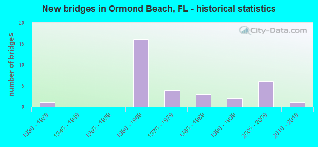
- New bridges - historical statistics
- 11930-1939
- 161960-1969
- 41970-1979
- 31980-1989
- 21990-1999
- 62000-2009
- 12010-2019

- Reconstructed bridges - Historical Statistics
- 11970-1979
- 11980-1989
- 11990-1999
- 72000-2009
- 12010-2019


- Bridge Condition - Deck
- 9.5%Very good
- 57.1%Good
- 19.0%Satisfactory
- 14.3%Fair

- Bridge Condition - Superstructure
- 9.5%Very good
- 47.6%Good
- 23.8%Satisfactory
- 19.0%Fair

- Bridge Condition - Substructure
- 14.3%Very good
- 52.4%Good
- 33.3%Satisfactory

- Bridge Condition - Channel
- 21.1%Very good
- 63.2%Good
- 10.5%Satisfactory
- 5.3%Fair

- Bridge Condition - Culverts
- 83.3%Good
- 16.7%Satisfactory
Find on map >> Show street view
Structure Number: 790026, Location: 2.96 Mi. West of I-95 (Lat: 29.256597, Lng: -81.164317), Route carried "on" structure: State highway 40, Year Built: 1965, Year Reconstructed: 2007, Status: Open, Structure Length: 0.88m (2.89ft), Average Daily Traffic: 13,300 (year 2020), Truck Traffic: 16%, Average Future Daily Traffic: 23,076 (year 2042), Design Load: HS 20, Features Intersected: Little Tomoka River
Minimum Vertical Clearance: 30+ m (98+ ft), Kilometerpoint: 37.517, Lanes on structure: 6, Base Highway Network: Yes, Owner: State Highway Agency, Approaching Roadway Width: 23.7m (77.8ft), Skew: 1 degrees, Material/Design: Concrete, Design/Construction: Culvert, Number Of Spans In Main Unit: 3, Length of Maximum Span: 2.7m (8.9ft)
Condition: Channel: Good, Culverts: Good, Operating Rating: 73.5 metric tons, Method Used To Determine Operating Rating: Load Factor (LF), Inventory Rating: 44.1 metric tons, Method Used To Determine Inventory Rating: Load Factor (LF), Structural Evaluation: Better than present minimum criteria, Waterway Adequacy: Equal to present desirable criteria, Approach Roadway Alignment: Equal to present desirable criteria, Designated Inspection Frequency: Every 24 months, Inspection Date: December 2020
Find on map >> Show street view
Structure Number: 790027, Location: SR-40 WB -Tomoka River (Lat: 29.254944, Lng: -81.123561), Route carried "on" structure: State highway 40, Year Built: 1965, Year Reconstructed: 1998, Status: Open, Structure Length: 11.06m (36.29ft), Average Daily Traffic: 13,250 (year 2020), Truck Traffic: 12%, Average Future Daily Traffic: 22,989 (year 2042), Design Load: H 20, Features Intersected: Tomoka River
Minimum Vertical Clearance: 30+ m (98+ ft), Kilometerpoint: 41.536, Lanes on structure: 2, Base Highway Network: Yes, Owner: State Highway Agency, Approaching Roadway Width: 10.3m (33.8ft), Material/Design: Prestressed concrete, Design/Construction: Stringer/Multi-beam, Number Of Spans In Main Unit: 9, Length of Maximum Span: 12.2m (40.0ft), Curb-To-Curb Width: 12.4m (40.7ft), Out-to-Out Width: 13.4m (44.0ft)
Condition: Deck: Satisfactory, Superstructure: Good, Substructure: Satisfactory, Channel: Good, Operating Rating: 60.6 metric tons, Method Used To Determine Operating Rating: Load Factor (LF), Inventory Rating: 37.6 metric tons, Method Used To Determine Inventory Rating: Load Factor (LF), Structural Evaluation: Equal to present minimum criteria, Deck Geometry: Better than present minimum criteria, Waterway Adequacy: Equal to present desirable criteria, Approach Roadway Alignment: Equal to present desirable criteria, Designated Inspection Frequency: Every 24 months, Underwater Inspection Frequency: Every 24 months, Inspection Date: September 2021, Underwater Inspection Date: October 2021, Deck Structure Type: Concrete Cast-file-Place, Wearing Surface/Protective System: Wearing Surface: Epoxy Overlay, Membrane: Epoxy
Find on map >> Show street view
Structure Number: 790077, Location: I-95 SB - Tomoka R. (Lat: 29.262722, Lng: -81.118111), Route carried "on" structure: Interstate 95, Year Built: 1965, Year Reconstructed: 2006, Status: Open, Structure Length: 15.99m (52.46ft), Average Daily Traffic: 29,000 (year 2020), Truck Traffic: 18%, Average Future Daily Traffic: 50,315 (year 2042), Design Load: HS 20+Mod, Features Intersected: Tomoka River
Minimum Vertical Clearance: 30+ m (98+ ft), Kilometerpoint: 57.333, Lanes on structure: 4, Base Highway Network: Yes, Owner: State Highway Agency, Approaching Roadway Width: 17.1m (56.1ft), Material/Design: Prestressed concrete, Design/Construction: Stringer/Multi-beam, Number Of Spans In Main Unit: 12, Length of Maximum Span: 13.4m (44.0ft), Curb-To-Curb Width: 20.6m (67.6ft), Out-to-Out Width: 21.5m (70.5ft)
Condition: Deck: Satisfactory, Superstructure: Satisfactory, Substructure: Satisfactory, Channel: Good, Operating Rating: 54.8 metric tons, Method Used To Determine Operating Rating: Load Factor (LF), Inventory Rating: 32.8 metric tons, Method Used To Determine Inventory Rating: Load Factor (LF), Structural Evaluation: Equal to present minimum criteria, Deck Geometry: Equal to present minimum criteria, Waterway Adequacy: Equal to present desirable criteria, Approach Roadway Alignment: Equal to present desirable criteria, Designated Inspection Frequency: Every 24 months, Underwater Inspection Frequency: Every 24 months, Inspection Date: May 2021, Underwater Inspection Date: May 2021, Deck Structure Type: Concrete Cast-file-Place
Find on map >> Show street view
Structure Number: 790078, Location: I-95 NB - Tomoka R. (Lat: 29.262661, Lng: -81.117817), Route carried "on" structure: Interstate 95, Year Built: 1965, Year Reconstructed: 2006, Status: Open, Structure Length: 15.99m (52.46ft), Average Daily Traffic: 29,000 (year 2020), Truck Traffic: 18%, Average Future Daily Traffic: 50,315 (year 2042), Design Load: HS 20+Mod, Features Intersected: Tomoka River
Minimum Vertical Clearance: 30+ m (98+ ft), Kilometerpoint: 57.333, Lanes on structure: 4, Base Highway Network: Yes, Owner: State Highway Agency, Approaching Roadway Width: 18.3m (60.0ft), Material/Design: Prestressed concrete, Design/Construction: Stringer/Multi-beam, Number Of Spans In Main Unit: 12, Length of Maximum Span: 13.4m (44.0ft), Curb-To-Curb Width: 20.6m (67.6ft), Out-to-Out Width: 21.5m (70.5ft)
Condition: Deck: Satisfactory, Superstructure: Satisfactory, Substructure: Satisfactory, Channel: Good, Operating Rating: 54.8 metric tons, Method Used To Determine Operating Rating: Load Factor (LF), Inventory Rating: 32.8 metric tons, Method Used To Determine Inventory Rating: Load Factor (LF), Structural Evaluation: Equal to present minimum criteria, Deck Geometry: Equal to present minimum criteria, Waterway Adequacy: Equal to present desirable criteria, Approach Roadway Alignment: Equal to present desirable criteria, Designated Inspection Frequency: Every 24 months, Underwater Inspection Frequency: Every 24 months, Inspection Date: May 2021, Underwater Inspection Date: May 2021, Deck Structure Type: Concrete Cast-file-Place
Find on map >> Show street view
Structure Number: 790079, Location: Airport Road - I-95 (Lat: 29.273983, Lng: -81.121908), Route carried "on" structure: County highway , Year Built: 1964, Status: Open, Structure Length: 6.78m (22.24ft), Average Daily Traffic: 5,700 (year 2020), Truck Traffic: 6%, Average Future Daily Traffic: 9,890 (year 2042), Design Load: HS 20, Features Intersected: I-95, Facility Carried by Structure: Airport Road
Minimum Vertical Clearance: 30+ m (98+ ft), Kilometerpoint: 2.971, Lanes on structure: 2, Lanes under structure: 6, Owner: State Highway Agency, Approaching Roadway Width: 8.5m (27.9ft), Skew: 1 degrees, Material/Design: Prestressed concrete, Design/Construction: Stringer/Multi-beam, Number Of Spans In Main Unit: 4, Length of Maximum Span: 22.3m (73.2ft), Curb-To-Curb Width: 8.5m (27.9ft), Out-to-Out Width: 10.4m (34.1ft)
Condition: Deck: Good, Superstructure: Satisfactory, Substructure: Good, Operating Rating: 52.4 metric tons, Method Used To Determine Operating Rating: Load Factor (LF), Inventory Rating: 32.7 metric tons, Method Used To Determine Inventory Rating: Load Factor (LF), Structural Evaluation: Equal to present minimum criteria, Deck Geometry: Meets minimum limits, Underclear: Somewhat better than minimum adequacy, Approach Roadway Alignment: Equal to present desirable criteria, Designated Inspection Frequency: Every 24 months, Inspection Date: March 2021, Deck Structure Type: Concrete Cast-file-Place
Find on map >> Show street view
Structure Number: 79008, Location: I-95 SB over FECRR (Lat: 29.333122, Lng: -81.131311), Route carried "on" structure: Interstate 95, Year Built: 1964, Year Reconstructed: 2005, Status: Open, Structure Length: 7.67m (25.16ft), Average Daily Traffic: 29,000 (year 2020), Truck Traffic: 18%, Average Future Daily Traffic: 50,315 (year 2042), Design Load: HS 20, Features Intersected: FECRR - Tymber Crk Rd
Minimum Vertical Clearance: 30+ m (98+ ft), Kilometerpoint: 65.359, Lanes on structure: 3, Lanes under structure: 2, Base Highway Network: Yes, Owner: State Highway Agency, Approaching Roadway Width: 15.8m (51.8ft), Skew: 3 degrees, Material/Design: Prestressed concrete, Design/Construction: Stringer/Multi-beam, Number Of Spans In Main Unit: 4, Length of Maximum Span: 20.6m (67.6ft), Curb-To-Curb Width: 16.8m (55.1ft), Out-to-Out Width: 17.7m (58.1ft)
Condition: Deck: Good, Superstructure: Good, Substructure: Good, Operating Rating: 56.4 metric tons, Method Used To Determine Operating Rating: Load Factor (LF), Inventory Rating: 33.9 metric tons, Method Used To Determine Inventory Rating: Load Factor (LF), Structural Evaluation: Better than present minimum criteria, Deck Geometry: Equal to present minimum criteria, Underclear: Meets minimum limits, Approach Roadway Alignment: Equal to present desirable criteria, Designated Inspection Frequency: Every 24 months, Inspection Date: April 2021, Deck Structure Type: Concrete Cast-file-Place
Find on map >> Show street view
Structure Number: 790081, Location: I-95 NB over FECRR (Lat: 29.332914, Lng: -81.131025), Route carried "on" structure: Interstate 95, Year Built: 1964, Year Reconstructed: 2005, Status: Open, Structure Length: 7.67m (25.16ft), Average Daily Traffic: 29,000 (year 2020), Truck Traffic: 18%, Average Future Daily Traffic: 50,315 (year 2042), Design Load: HS 20, Features Intersected: FECRR - Tymber Crk Rd
Minimum Vertical Clearance: 30+ m (98+ ft), Kilometerpoint: 65.359, Lanes on structure: 3, Lanes under structure: 2, Base Highway Network: Yes, Owner: State Highway Agency, Approaching Roadway Width: 15.8m (51.8ft), Skew: 3 degrees, Material/Design: Prestressed concrete, Design/Construction: Stringer/Multi-beam, Number Of Spans In Main Unit: 4, Length of Maximum Span: 20.6m (67.6ft), Curb-To-Curb Width: 16.8m (55.1ft), Out-to-Out Width: 17.7m (58.1ft)
Condition: Deck: Good, Superstructure: Good, Substructure: Good, Operating Rating: 56.4 metric tons, Method Used To Determine Operating Rating: Load Factor (LF), Inventory Rating: 33.9 metric tons, Method Used To Determine Inventory Rating: Load Factor (LF), Structural Evaluation: Better than present minimum criteria, Deck Geometry: Equal to present minimum criteria, Underclear: Somewhat better than minimum adequacy, Approach Roadway Alignment: Equal to present desirable criteria, Designated Inspection Frequency: Every 24 months, Inspection Date: April 2021, Deck Structure Type: Concrete Cast-file-Place
Find on map >> Show street view
Structure Number: 790082, Location: I-95 SB over US-1 (Lat: 29.336011, Lng: -81.131222), Route carried "on" structure: Interstate 95, Year Built: 1964, Year Reconstructed: 2010, Status: Open, Structure Length: 7.92m (25.98ft), Average Daily Traffic: 29,000 (year 2020), Truck Traffic: 18%, Average Future Daily Traffic: 50,315 (year 2042), Design Load: HS 20, Features Intersected: US-1
Minimum Vertical Clearance: 30+ m (98+ ft), Kilometerpoint: 65.676, Lanes on structure: 4, Lanes under structure: 6, Base Highway Network: Yes, Owner: State Highway Agency, Approaching Roadway Width: 20.1m (65.9ft), Skew: 3 degrees, Material/Design: Prestressed concrete, Design/Construction: Stringer/Multi-beam, Number Of Spans In Main Unit: 4, Length of Maximum Span: 25.0m (82.0ft), Curb-To-Curb Width: 20.4m (66.9ft), Out-to-Out Width: 21.4m (70.2ft)
Condition: Deck: Good, Superstructure: Fair, Substructure: Good, Operating Rating: 59.0 metric tons, Method Used To Determine Operating Rating: Load Factor (LF), Inventory Rating: 35.4 metric tons, Method Used To Determine Inventory Rating: Load Factor (LF), Structural Evaluation: Somewhat better than minimum adequacy, Deck Geometry: Equal to present minimum criteria, Underclear: Somewhat better than minimum adequacy, Approach Roadway Alignment: Equal to present desirable criteria, Designated Inspection Frequency: Every 24 months, Inspection Date: April 2021, Deck Structure Type: Concrete Cast-file-Place
Find on map >> Show street view
Structure Number: 790083, Location: I-95 NB over US-1 (Lat: 29.335833, Lng: -81.130972), Route carried "on" structure: Interstate 95, Year Built: 1964, Year Reconstructed: 2005, Status: Open, Structure Length: 7.92m (25.98ft), Average Daily Traffic: 29,000 (year 2020), Truck Traffic: 18%, Average Future Daily Traffic: 50,315 (year 2042), Design Load: HS 20, Features Intersected: US-1
Minimum Vertical Clearance: 30+ m (98+ ft), Kilometerpoint: 65.676, Lanes on structure: 4, Lanes under structure: 6, Base Highway Network: Yes, Owner: State Highway Agency, Approaching Roadway Width: 19.2m (63.0ft), Skew: 3 degrees, Material/Design: Prestressed concrete, Design/Construction: Stringer/Multi-beam, Number Of Spans In Main Unit: 4, Length of Maximum Span: 25.0m (82.0ft), Curb-To-Curb Width: 19.2m (63.0ft), Out-to-Out Width: 20.2m (66.3ft)
Condition: Deck: Good, Superstructure: Good, Substructure: Good, Operating Rating: 53.6 metric tons, Method Used To Determine Operating Rating: Load Factor (LF), Inventory Rating: 32.2 metric tons, Method Used To Determine Inventory Rating: Load Factor (LF), Structural Evaluation: Better than present minimum criteria, Deck Geometry: Somewhat better than minimum adequacy, Underclear: Somewhat better than minimum adequacy, Approach Roadway Alignment: Equal to present desirable criteria, Designated Inspection Frequency: Every 24 months, Inspection Date: April 2021, Deck Structure Type: Concrete Cast-file-Place
Find on map >> Show street view
Structure Number: 790119, Location: 1.4 Mi N of SR-40 (Lat: 29.296075, Lng: -81.079586), Route carried "on" structure: US 1, Year Built: 1932, Year Reconstructed: 1981, Status: Open, Structure Length: 0.62m (2.03ft), Average Daily Traffic: 19,500 (year 2020), Truck Traffic: 8%, Average Future Daily Traffic: 33,832 (year 2042), Design Load: H 15, Features Intersected: Unsigned Creek
Minimum Vertical Clearance: 30+ m (98+ ft), Kilometerpoint: 11.183, Lanes on structure: 4, Base Highway Network: Yes, Owner: State Highway Agency, Approaching Roadway Width: 19.2m (63.0ft), Skew: 20 degrees, Material/Design: Concrete, Design/Construction: Culvert, Number Of Spans In Main Unit: 2, Length of Maximum Span: 3.0m (9.8ft)
Condition: Channel: Good, Culverts: Good, Operating Rating: 83.6 metric tons, Method Used To Determine Operating Rating: Load Factor (LF), Inventory Rating: 50.2 metric tons, Method Used To Determine Inventory Rating: Load Factor (LF), Structural Evaluation: Better than present minimum criteria, Waterway Adequacy: Equal to present desirable criteria, Approach Roadway Alignment: Equal to present desirable criteria, Designated Inspection Frequency: Every 24 months, Inspection Date: June 2021
Find on map >> Show street view
Structure Number: 790132, Location: SR-40 over IWW (Lat: 29.287278, Lng: -81.051706), Route carried "on" structure: State highway 40, Year Built: 1983, Status: Open, Structure Length: 58.67m (192.49ft), Average Daily Traffic: 38,500 (year 2020), Truck Traffic: 6%, Average Future Daily Traffic: 66,798 (year 2042), Design Load: HS 20, Features Intersected: Halifax River IWW
Minimum Vertical Clearance: 30+ m (98+ ft), Kilometerpoint: 0.819, Lanes on structure: 4, Base Highway Network: Yes, Owner: State Highway Agency, Approaching Roadway Width: 23.1m (75.8ft), Skew: 30 degrees, Navigation Control: Yes ( Vertical Clearance: 19.6m (64.3ft), Horizontal Clearance: 27.4m (89.9ft)), Material/Design: Prestressed concrete, Design/Construction: Stringer/Multi-beam, Number Of Spans In Main Unit: 19, Length of Maximum Span: 37.5m (123.0ft), Curb or Sidewalk Widths: Left: 1.5m (4.9ft), Right: 1.5m (4.9ft), Curb-To-Curb Width: 23.5m (77.1ft), Out-to-Out Width: 28.8m (94.5ft)
Condition: Deck: Good, Superstructure: Good, Substructure: Satisfactory, Channel: Good, Operating Rating: 80.0 metric tons, Method Used To Determine Operating Rating: Load Factor (LF), Inventory Rating: 48.3 metric tons, Method Used To Determine Inventory Rating: Load Factor (LF), Structural Evaluation: Equal to present minimum criteria, Deck Geometry: Superior to present desirable criteria, Waterway Adequacy: Equal to present desirable criteria, Approach Roadway Alignment: Equal to present desirable criteria, Length Of Structure Improvement: 58.61m (192.29ft), Designated Inspection Frequency: Every 24 months, Underwater Inspection Frequency: Every 24 months, Inspection Date: August 2020, Underwater Inspection Date: September 2020, Bridge Improvement Cost: $80,000, Total Project Cost: $105,000, Deck Structure Type: Concrete Cast-file-Place, Wearing Surface/Protective System: Wearing Surface: Monolithic Concrete, Deck Protection: Bituminous
Find on map >> Show street view
Structure Number: 790163, Location: SR-40 EB - Tomoka River (Lat: 29.254717, Lng: -81.123592), Route carried "on" structure: State highway 40, Year Built: 1997, Status: Open, Structure Length: 10.97m (35.99ft), Average Daily Traffic: 13,250 (year 2020), Truck Traffic: 12%, Average Future Daily Traffic: 22,989 (year 2042), Design Load: HS 20+Mod, Features Intersected: Tomoka River
Minimum Vertical Clearance: 30+ m (98+ ft), Kilometerpoint: 41.536, Lanes on structure: 2, Base Highway Network: Yes, Owner: State Highway Agency, Approaching Roadway Width: 10.1m (33.1ft), Skew: 2 degrees, Material/Design: Prestressed concrete, Design/Construction: Stringer/Multi-beam, Number Of Spans In Main Unit: 5, Length of Maximum Span: 21.9m (71.9ft), Curb-To-Curb Width: 12.2m (40.0ft), Out-to-Out Width: 13.4m (44.0ft)
Condition: Deck: Good, Superstructure: Good, Substructure: Good, Channel: Good, Operating Rating: 72.5 metric tons, Method Used To Determine Operating Rating: Load Factor (LF), Inventory Rating: 44.8 metric tons, Method Used To Determine Inventory Rating: Load Factor (LF), Structural Evaluation: Better than present minimum criteria, Deck Geometry: Better than present minimum criteria, Waterway Adequacy: Equal to present desirable criteria, Approach Roadway Alignment: Equal to present desirable criteria, Designated Inspection Frequency: Every 24 months, Underwater Inspection Frequency: Every 24 months, Inspection Date: September 2021, Underwater Inspection Date: October 2021, Deck Structure Type: Concrete Cast-file-Place, Wearing Surface/Protective System: Wearing Surface: Monolithic Concrete
Find on map >> Show street view
Structure Number: 790182, Location: SR-40 west of SR-5A (Lat: 29.278219, Lng: -81.088442), Route carried "on" structure: State highway 40, Year Built: 1994, Status: Open, Structure Length: 0.85m (2.79ft), Average Daily Traffic: 35,500 (year 2020), Truck Traffic: 4%, Average Future Daily Traffic: 61,592 (year 2042), Design Load: HS 20+Mod, Features Intersected: Misner Creek
Minimum Vertical Clearance: 30+ m (98+ ft), Kilometerpoint: 45.982, Lanes on structure: 5, Owner: State Highway Agency, Approaching Roadway Width: 17.9m (58.7ft), Skew: 20 degrees, Material/Design: Concrete, Design/Construction: Culvert, Number Of Spans In Main Unit: 3, Length of Maximum Span: 2.7m (8.9ft)
Condition: Channel: Satisfactory, Culverts: Good, Operating Rating: 85.2 metric tons, Method Used To Determine Operating Rating: Load Factor (LF), Inventory Rating: 51.2 metric tons, Method Used To Determine Inventory Rating: Load Factor (LF), Structural Evaluation: Better than present minimum criteria, Waterway Adequacy: Superior to present desirable criteria, Approach Roadway Alignment: Equal to present desirable criteria, Designated Inspection Frequency: Every 24 months, Inspection Date: December 2020
Find on map >> Show street view
Structure Number: 790185, Location: US-1 SB - Tomoka River (Lat: 29.305056, Lng: -81.094197), Route carried "on" structure: US 1, Year Built: 2001, Status: Open, Structure Length: 10.73m (35.20ft), Average Daily Traffic: 15,500 (year 2020), Truck Traffic: 8%, Average Future Daily Traffic: 26,892 (year 2042), Design Load: HS 20, Features Intersected: Tomoka River
Minimum Vertical Clearance: 30+ m (98+ ft), Kilometerpoint: 12.886, Lanes on structure: 2, Base Highway Network: Yes, Owner: State Highway Agency, Approaching Roadway Width: 10.2m (33.5ft), Material/Design: Prestressed concrete, Design/Construction: Stringer/Multi-beam, Number Of Spans In Main Unit: 7, Length of Maximum Span: 15.2m (49.9ft), Curb or Sidewalk Widths: Left: 3.0m (9.8ft), Right: 0.0m, Curb-To-Curb Width: 12.6m (41.3ft), Out-to-Out Width: 15.3m (50.2ft)
Condition: Deck: Good, Superstructure: Good, Substructure: Good, Channel: Very good, Operating Rating: 58.5 metric tons, Method Used To Determine Operating Rating: Load Factor (LF), Inventory Rating: 36.3 metric tons, Method Used To Determine Inventory Rating: Load Factor (LF), Structural Evaluation: Better than present minimum criteria, Deck Geometry: Better than present minimum criteria, Waterway Adequacy: Equal to present desirable criteria, Approach Roadway Alignment: Equal to present desirable criteria, Designated Inspection Frequency: Every 24 months, Underwater Inspection Frequency: Every 24 months, Inspection Date: August 2021, Underwater Inspection Date: September 2021, Deck Structure Type: Concrete Cast-file-Place, Wearing Surface/Protective System: Wearing Surface: Monolithic Concrete
Find on map >> Show street view
Structure Number: 790186, Location: US-1 NB - Tomoka River (Lat: 29.305189, Lng: -81.093964), Route carried "on" structure: US 1, Year Built: 2000, Status: Open, Structure Length: 10.73m (35.20ft), Average Daily Traffic: 15,500 (year 2020), Truck Traffic: 8%, Average Future Daily Traffic: 26,892 (year 2042), Design Load: HS 20, Features Intersected: Tomoka River
Minimum Vertical Clearance: 30+ m (98+ ft), Kilometerpoint: 12.886, Lanes on structure: 2, Base Highway Network: Yes, Owner: State Highway Agency, Approaching Roadway Width: 10.2m (33.5ft), Material/Design: Prestressed concrete, Design/Construction: Stringer/Multi-beam, Number Of Spans In Main Unit: 7, Length of Maximum Span: 15.3m (50.2ft), Curb or Sidewalk Widths: Left: 0.0m, Right: 3.0m (9.8ft), Curb-To-Curb Width: 12.6m (41.3ft), Out-to-Out Width: 15.3m (50.2ft)
Condition: Deck: Good, Superstructure: Good, Substructure: Good, Channel: Very good, Operating Rating: 60.1 metric tons, Method Used To Determine Operating Rating: Load Factor (LF), Inventory Rating: 36.0 metric tons, Method Used To Determine Inventory Rating: Load Factor (LF), Structural Evaluation: Better than present minimum criteria, Deck Geometry: Better than present minimum criteria, Waterway Adequacy: Equal to present desirable criteria, Approach Roadway Alignment: Equal to present desirable criteria, Designated Inspection Frequency: Every 24 months, Underwater Inspection Frequency: Every 24 months, Inspection Date: August 2021, Underwater Inspection Date: September 2021, Deck Structure Type: Concrete Cast-file-Place, Wearing Surface/Protective System: Wearing Surface: Monolithic Concrete
Find on map >> Show street view
Structure Number: 790193, Location: I-95 over SR-40 (Lat: 29.256983, Lng: -81.115944), Route carried "on" structure: Interstate 95, Year Built: 2006, Status: Open, Structure Length: 4.69m (15.39ft), Average Daily Traffic: 83,000 (year 2020), Truck Traffic: 18%, Average Future Daily Traffic: 144,005 (year 2042), Design Load: HS 20+Mod, Features Intersected: SR-40
Minimum Vertical Clearance: 30+ m (98+ ft), Kilometerpoint: 56.726, Lanes on structure: 6, Lanes under structure: 8, Base Highway Network: Yes, Owner: State Highway Agency, Approaching Roadway Width: 33.5m (109.9ft), Skew: 30 degrees, Material/Design: Steel, Design/Construction: Stringer/Multi-beam, Number Of Spans In Main Unit: 1, Length of Maximum Span: 46.9m (153.9ft), Curb-To-Curb Width: 39.6m (129.9ft), Out-to-Out Width: 41.1m (134.8ft)
Condition: Deck: Very good, Superstructure: Very good, Substructure: Good, Operating Rating: 65.8 metric tons, Method Used To Determine Operating Rating: Load Factor (LF), Inventory Rating: 39.5 metric tons, Method Used To Determine Inventory Rating: Load Factor (LF), Structural Evaluation: Better than present minimum criteria, Deck Geometry: Superior to present desirable criteria, Underclear: Equal to present minimum criteria, Approach Roadway Alignment: Equal to present desirable criteria, Designated Inspection Frequency: Every 24 months, Inspection Date: July 2020, Deck Structure Type: Concrete Cast-file-Place
Find on map >> Show street view
Structure Number: 790194, Location: SR-40 WB - Habitat Connec (Lat: 29.258933, Lng: -81.185492), Route carried "on" structure: State highway 40, Year Built: 2007, Status: Open, Structure Length: 1.19m (3.90ft), Average Daily Traffic: 3,350 (year 2020), Truck Traffic: 13%, Average Future Daily Traffic: 5,812 (year 2042), Design Load: HS 20, Features Intersected: Habitat Connectivity
Minimum Vertical Clearance: 30+ m (98+ ft), Kilometerpoint: 35.183, Lanes on structure: 2, Base Highway Network: Yes, Owner: State Highway Agency, Approaching Roadway Width: 12.2m (40.0ft), Material/Design: Concrete, Design/Construction: Slab, Number Of Spans In Main Unit: 1, Length of Maximum Span: 11.3m (37.1ft), Curb-To-Curb Width: 12.2m (40.0ft), Out-to-Out Width: 13.1m (43.0ft)
Condition: Deck: Very good, Superstructure: Very good, Substructure: Very good, Operating Rating: 86.2 metric tons, Method Used To Determine Operating Rating: Load Factor (LF), Inventory Rating: 51.7 metric tons, Method Used To Determine Inventory Rating: Load Factor (LF), Structural Evaluation: Equal to present desirable criteria, Deck Geometry: Better than present minimum criteria, Approach Roadway Alignment: Equal to present desirable criteria, Designated Inspection Frequency: Every 24 months, Inspection Date: December 2020, Deck Structure Type: Concrete Cast-file-Place, Wearing Surface/Protective System: Wearing Surface: Monolithic Concrete
Find on map >> Show street view
Structure Number: 790195, Location: SR-40EB - Habitat Connect (Lat: 29.258772, Lng: -81.185397), Route carried "on" structure: State highway 40, Year Built: 2006, Status: Open, Structure Length: 1.19m (3.90ft), Average Daily Traffic: 3,350 (year 2020), Truck Traffic: 13%, Average Future Daily Traffic: 5,812 (year 2042), Design Load: HS 20, Features Intersected: Habitat Connectivity
Minimum Vertical Clearance: 30+ m (98+ ft), Kilometerpoint: 35.183, Lanes on structure: 2, Base Highway Network: Yes, Owner: State Highway Agency, Approaching Roadway Width: 10.2m (33.5ft), Material/Design: Concrete, Design/Construction: Slab, Number Of Spans In Main Unit: 1, Length of Maximum Span: 11.3m (37.1ft), Curb-To-Curb Width: 12.2m (40.0ft), Out-to-Out Width: 13.1m (43.0ft)
Condition: Deck: Good, Superstructure: Good, Substructure: Good, Operating Rating: 86.2 metric tons, Method Used To Determine Operating Rating: Load Factor (LF), Inventory Rating: 51.7 metric tons, Method Used To Determine Inventory Rating: Load Factor (LF), Structural Evaluation: Better than present minimum criteria, Deck Geometry: Better than present minimum criteria, Approach Roadway Alignment: Equal to present desirable criteria, Designated Inspection Frequency: Every 24 months, Inspection Date: December 2020, Deck Structure Type: Concrete Cast-file-Place, Wearing Surface/Protective System: Wearing Surface: Monolithic Concrete
Find on map >> Show street view
Structure Number: 79092, Location: SR-40 over Middle Haw Cr. (Lat: 29.244322, Lng: -81.225936), Route carried "on" structure: State highway 40, Year Built: 1965, Status: Open, Structure Length: 4.63m (15.19ft), Average Daily Traffic: 6,700 (year 2020), Truck Traffic: 13%, Average Future Daily Traffic: 11,624 (year 2042), Design Load: HS 20, Features Intersected: Middle Haw Creek
Minimum Vertical Clearance: 30+ m (98+ ft), Kilometerpoint: 30.785, Lanes on structure: 2, Base Highway Network: Yes, Owner: State Highway Agency, Approaching Roadway Width: 9.7m (31.8ft), Material/Design: Concrete, Design/Construction: Slab, Number Of Spans In Main Unit: 5, Length of Maximum Span: 9.1m (29.9ft), Curb-To-Curb Width: 12.9m (42.3ft), Out-to-Out Width: 14.0m (45.9ft)
Condition: Deck: Satisfactory, Superstructure: Satisfactory, Substructure: Good, Channel: Very good, Operating Rating: 66.8 metric tons, Method Used To Determine Operating Rating: Load Factor (LF), Inventory Rating: 40.0 metric tons, Method Used To Determine Inventory Rating: Load Factor (LF), Structural Evaluation: Equal to present minimum criteria, Deck Geometry: Somewhat better than minimum adequacy, Waterway Adequacy: Equal to present desirable criteria, Approach Roadway Alignment: Equal to present desirable criteria, Designated Inspection Frequency: Every 24 months, Inspection Date: March 2021, Deck Structure Type: Concrete Cast-file-Place, Wearing Surface/Protective System: Wearing Surface: Monolithic Concrete
Find on map >> Show street view
Structure Number: 794016, Location: 0.4 mi S of Addison Drive (Lat: 29.342186, Lng: -81.086317), Route carried "on" structure: County highway 4011, Year Built: 1964, Year Reconstructed: 2011, Status: Open, Structure Length: 6.86m (22.51ft), Average Daily Traffic: 1,401 (year 2020), Truck Traffic: 5%, Average Future Daily Traffic: 1,696 (year 2042), Features Intersected: Tomoka River, Facility Carried by Structure: Old Dixie Hwy.
Minimum Vertical Clearance: 30+ m (98+ ft), Kilometerpoint: 6.977, Lanes on structure: 2, Owner: County Highway Agency, Approaching Roadway Width: 7.9m (25.9ft), Navigation Control: Yes ( Vertical Clearance: 4.2m (13.8ft), Horizontal Clearance: 10.3m (33.8ft)), Material/Design: Steel, Design/Construction: Stringer/Multi-beam, Number Of Spans In Main Unit: 1, Number Of Approach Spans: 7, Length of Maximum Span: 10.4m (34.1ft), Curb or Sidewalk Widths: Left: 0.6m (2.0ft), Right: 0.6m (2.0ft), Curb-To-Curb Width: 7.9m (25.9ft), Out-to-Out Width: 9.8m (32.2ft)
Condition: Deck: Fair, Superstructure: Fair, Substructure: Satisfactory, Channel: Satisfactory, Operating Rating: 45.1 metric tons, Method Used To Determine Operating Rating: Load Factor (LF), Inventory Rating: 27.0 metric tons, Method Used To Determine Inventory Rating: Load Factor (LF), Structural Evaluation: Somewhat better than minimum adequacy, Deck Geometry: Meets minimum limits, Waterway Adequacy: Equal to present desirable criteria, Approach Roadway Alignment: Better than present minimum criteria, Designated Inspection Frequency: Every 24 months, Underwater Inspection Frequency: Every 24 months, Inspection Date: April 2020, Underwater Inspection Date: May 2020, Deck Structure Type: Open Grating
Find on map >> Show street view
Structure Number: 794036, Location: 0.1 Mi E of Tymber Crk Rd (Lat: 29.273889, Lng: -81.127936), Route carried "on" structure: County highway , Year Built: 1975, Status: Open, Structure Length: 1.06m (3.48ft), Average Daily Traffic: 5,900 (year 2020), Truck Traffic: 5%, Average Future Daily Traffic: 10,236 (year 2042), Design Load: HS 20, Features Intersected: Groover Creek, Facility Carried by Structure: Airport Road
Minimum Vertical Clearance: 30+ m (98+ ft), Kilometerpoint: 2.422, Lanes on structure: 2, Owner: County Highway Agency, Approaching Roadway Width: 9.6m (31.5ft), Material/Design: Prestressed concrete, Design/Construction: Slab, Number Of Spans In Main Unit: 1, Length of Maximum Span: 10.6m (34.8ft), Curb or Sidewalk Widths: Left: 0.2m (0.7ft), Right: 1.4m (4.6ft), Curb-To-Curb Width: 8.7m (28.5ft), Out-to-Out Width: 11.1m (36.4ft)
Condition: Deck: Good, Superstructure: Good, Substructure: Satisfactory, Channel: Good, Operating Rating: 81.6 metric tons, Method Used To Determine Operating Rating: Load Factor (LF), Inventory Rating: 48.9 metric tons, Method Used To Determine Inventory Rating: Load Factor (LF), Structural Evaluation: Equal to present minimum criteria, Deck Geometry: High priority of replacement, Waterway Adequacy: Equal to present desirable criteria, Approach Roadway Alignment: Equal to present desirable criteria, Designated Inspection Frequency: Every 24 months, Inspection Date: April 2020, Deck Structure Type: Concrete Precast Panels, Wearing Surface/Protective System: Wearing Surface: Bituminous
Find on map >> Show street view
Structure Number: 794072, Location: 1.6 miles North of SR-40 (Lat: 29.277219, Lng: -81.129528), Route carried "on" structure: County highway , Year Built: 1972, Status: Open, Structure Length: 1.37m (4.49ft), Average Daily Traffic: 401 (year 2020), Truck Traffic: 5%, Average Future Daily Traffic: 485 (year 2042), Design Load: HS 20, Features Intersected: Groover Creek, Facility Carried by Structure: Tymber Creek Road
Minimum Vertical Clearance: 30+ m (98+ ft), Kilometerpoint: 0.016, Lanes on structure: 2, Owner: County Highway Agency, Approaching Roadway Width: 6.8m (22.3ft), Skew: 3 degrees, Material/Design: Concrete, Design/Construction: Culvert, Number Of Spans In Main Unit: 3, Length of Maximum Span: 4.4m (14.4ft)
Condition: Channel: Fair, Culverts: Good, Operating Rating: 62.9 metric tons, Method Used To Determine Operating Rating: Load Factor (LF), Inventory Rating: 37.7 metric tons, Method Used To Determine Inventory Rating: Load Factor (LF), Structural Evaluation: Better than present minimum criteria, Waterway Adequacy: Better than present minimum criteria, Approach Roadway Alignment: Equal to present desirable criteria, Designated Inspection Frequency: Every 24 months, Underwater Inspection Frequency: Every 24 months, Inspection Date: April 2020, Underwater Inspection Date: April 2020
Find on map >> Show street view
Structure Number: 794082, Location: 3.0 Mi. North of SR-40 (Lat: 29.295578, Lng: -81.130019), Route carried "on" structure: County highway , Year Built: 1972, Status: Open, Structure Length: 0.64m (2.10ft), Average Daily Traffic: 401 (year 2020), Truck Traffic: 5%, Average Future Daily Traffic: 485 (year 2042), Design Load: HS 20, Features Intersected: Trib to Groover Creek, Facility Carried by Structure: N. Tymber Creek Rd
Minimum Vertical Clearance: 30+ m (98+ ft), Kilometerpoint: 0.016, Lanes on structure: 2, Owner: County Highway Agency, Approaching Roadway Width: 6.7m (22.0ft), Skew: 1 degrees, Material/Design: Concrete, Design/Construction: Culvert, Number Of Spans In Main Unit: 2, Length of Maximum Span: 3.1m (10.2ft)
Condition: Channel: Good, Culverts: Satisfactory, Inventory Rating: 54.5 metric tons, Method Used To Determine Inventory Rating: Load Factor (LF), Structural Evaluation: Equal to present minimum criteria, Waterway Adequacy: Equal to present minimum criteria, Approach Roadway Alignment: Equal to present desirable criteria, Designated Inspection Frequency: Every 24 months, Inspection Date: April 2020
Find on map >> Show street view
Structure Number: 794123, Location: 0.8 Mi. N of Pine Tree Dr (Lat: 29.353408, Lng: -81.102561), Route carried "on" structure: County highway 5, Year Built: 1980, Status: Open, Structure Length: 1.07m (3.51ft), Average Daily Traffic: 1,340 (year 2020), Truck Traffic: 5%, Average Future Daily Traffic: 4,858 (year 2042), Design Load: HS 20, Features Intersected: Drainage Canal, Facility Carried by Structure: Old Dixie Highway
Minimum Vertical Clearance: 30+ m (98+ ft), Kilometerpoint: 2.008, Lanes on structure: 2, Owner: County Highway Agency, Approaching Roadway Width: 6.4m (21.0ft), Material/Design: Prestressed concrete, Design/Construction: Slab, Number Of Spans In Main Unit: 1, Length of Maximum Span: 10.7m (35.1ft), Curb-To-Curb Width: 10.4m (34.1ft), Out-to-Out Width: 11.2m (36.7ft)
Condition: Deck: Fair, Superstructure: Fair, Substructure: Very good, Channel: Good, Operating Rating: 55.5 metric tons, Method Used To Determine Operating Rating: Load Factor (LF), Inventory Rating: 30.4 metric tons, Method Used To Determine Inventory Rating: Load Factor (LF), Structural Evaluation: Somewhat better than minimum adequacy, Deck Geometry: Equal to present minimum criteria, Waterway Adequacy: Equal to present minimum criteria, Approach Roadway Alignment: Better than present minimum criteria, Designated Inspection Frequency: Every 24 months, Inspection Date: May 2020, Deck Structure Type: Concrete Precast Panels, Wearing Surface/Protective System: Wearing Surface: Bituminous
Find on map >> Show street view
Structure Number: 794124, Location: 0.5 Mi. N of Pine Tree Ln (Lat: 29.351153, Lng: -81.099392), Route carried "on" structure: County highway 5, Year Built: 1980, Status: Open, Structure Length: 1.10m (3.61ft), Average Daily Traffic: 1,340 (year 2020), Truck Traffic: 5%, Average Future Daily Traffic: 1,603 (year 2042), Design Load: HS 20, Features Intersected: Canal, Facility Carried by Structure: Old Dixie Highway
Minimum Vertical Clearance: 30+ m (98+ ft), Kilometerpoint: 1.616, Lanes on structure: 2, Owner: County Highway Agency, Approaching Roadway Width: 6.1m (20.0ft), Material/Design: Prestressed concrete, Design/Construction: Slab, Number Of Spans In Main Unit: 1, Length of Maximum Span: 11.0m (36.1ft), Curb-To-Curb Width: 10.4m (34.1ft), Out-to-Out Width: 11.2m (36.7ft)
Condition: Deck: Fair, Superstructure: Fair, Substructure: Very good, Channel: Good, Operating Rating: 51.3 metric tons, Method Used To Determine Operating Rating: Load Factor (LF), Inventory Rating: 27.8 metric tons, Method Used To Determine Inventory Rating: Load Factor (LF), Structural Evaluation: Somewhat better than minimum adequacy, Deck Geometry: Equal to present minimum criteria, Waterway Adequacy: Equal to present desirable criteria, Approach Roadway Alignment: Equal to present desirable criteria, Designated Inspection Frequency: Every 24 months, Inspection Date: May 2020, Deck Structure Type: Concrete Precast Panels, Wearing Surface/Protective System: Wearing Surface: Bituminous
Find on map >> Show street view
Structure Number: 794194, Location: 0.2 Miles North of SR 40 (Lat: 29.256806, Lng: -81.129000), Route carried "on" structure: County highway 2813, Year Built: 2014, Status: Open, Structure Length: 2.13m (6.99ft), Average Daily Traffic: 14,500 (year 2020), Truck Traffic: 21%, Average Future Daily Traffic: 25,158 (year 2042), Design Load: HL 93, Features Intersected: Little Tomoka River, Facility Carried by Structure: Tymber Creek Road
Minimum Vertical Clearance: 30+ m (98+ ft), Kilometerpoint: 0.369, Lanes on structure: 4, Owner: County Highway Agency, Approaching Roadway Width: 24.7m (81.0ft), Skew: 20 degrees, Material/Design: Concrete, Design/Construction: Culvert, Number Of Spans In Main Unit: 6, Length of Maximum Span: 3.0m (9.8ft)
Condition: Channel: Very good, Culverts: Good, Operating Rating: 69.9 metric tons, Method Used To Determine Operating Rating: Load and Resistance Factor (LRFR), Inventory Rating: 53.9 metric tons, Method Used To Determine Inventory Rating: Load and Resistance Factor (LRFR), Structural Evaluation: Better than present minimum criteria, Waterway Adequacy: Better than present minimum criteria, Approach Roadway Alignment: Equal to present desirable criteria, Designated Inspection Frequency: Every 24 months, Underwater Inspection Frequency: Every 24 months, Inspection Date: November 2020, Underwater Inspection Date: November 2020
Find on map >> Show street view
Structure Number: 796, Location: 0.8 Mile West of Nova Rd (Lat: 29.281550, Lng: -81.094747), Route carried "on" structure: City street , Year Built: 1979, Year Reconstructed: 1991, Status: Posted for load, Structure Length: 9.14m (29.99ft), Average Daily Traffic: 5,792 (year 2021), Truck Traffic: 5%, Average Future Daily Traffic: 7,008 (year 2042), Design Load: H 15, Features Intersected: Misner Branch, Facility Carried by Structure: Main Trail
Minimum Vertical Clearance: 30+ m (98+ ft), Kilometerpoint: 0.016, Lanes on structure: 2, Owner: City or Municipal Highway Agency, Approaching Roadway Width: 6.9m (22.6ft), Material/Design: Wood or Timber, Design/Construction: Stringer/Multi-beam, Number Of Spans In Main Unit: 20, Length of Maximum Span: 4.6m (15.1ft), Curb or Sidewalk Widths: Left: 0.0m, Right: 2.7m (8.9ft), Curb-To-Curb Width: 7.5m (24.6ft), Out-to-Out Width: 11.2m (36.7ft)
Condition: Deck: Good, Superstructure: Satisfactory, Substructure: Satisfactory, Channel: Good, Operating Rating: 25.4 metric tons, Method Used To Determine Operating Rating: Allowable Stress (AS), Inventory Rating: 17.2 metric tons, Method Used To Determine Inventory Rating: Allowable Stress (AS), Structural Evaluation: Meets minimum limits, Deck Geometry: High priority of replacement, Waterway Adequacy: Equal to present desirable criteria, Approach Roadway Alignment: Better than present minimum criteria, Bridge Posting: Required (Relationship of Operating Rating to Maximum Legal Load: 20.0 - 29.9% below), Designated Inspection Frequency: Every 24 months, Other Special Inspection Frequency: Every 12 months, Inspection Date: May 2020, Other Special Inspection Date: May 2021, Deck Structure Type: Wood or Timber, Wearing Surface/Protective System: Wearing Surface: Bituminous
Find on map >> Show street view
Structure Number: 790079, Location: Airport Road - I-95 (Lat: 29.273983, Lng: -81.121908), Route carried "under" structure: Interstate 95, Year Built: 1964, Structure Length: 0. m, Average Daily Traffic: 58,000 (year 2020), Truck Traffic: 18%, Features Intersected: I-95, Facility Carried by Structure: Airport Road
Minimum Vertical Clearance: 4.85m (15.91ft), Kilometerpoint: 58.625, Lanes on structure: 2, Lanes under structure: 6, Material/Design: Prestressed concrete, Design/Construction: Stringer/Multi-beam, Length of Maximum Span: 22.3m (73.2ft)
Find on map >> Show street view
Structure Number: 79008, Location: I-95 SB over FECRR (Lat: 29.333122, Lng: -81.131311), Route carried "under" structure: County highway , Year Built: 1964, Structure Length: 0. m, Average Daily Traffic: 600 (year 2020), Truck Traffic: 2%, Features Intersected: FECRR - Tymber Crk Rd, Facility Carried by Structure: I-95 SB
Minimum Vertical Clearance: 6.80m (22.31ft), Kilometerpoint: 0.000, Lanes on structure: 3, Lanes under structure: 2, Material/Design: Prestressed concrete, Design/Construction: Stringer/Multi-beam, Length of Maximum Span: 20.6m (67.6ft)
Find on map >> Show street view
Structure Number: 790081, Location: I-95 NB over FECRR (Lat: 29.332914, Lng: -81.131025), Route carried "under" structure: County highway , Year Built: 1964, Structure Length: 0. m, Average Daily Traffic: 600 (year 2020), Truck Traffic: 1%, Features Intersected: FECRR - Tymber Crk Rd, Facility Carried by Structure: I-95 NB
Minimum Vertical Clearance: 6.80m (22.31ft), Kilometerpoint: 0.000, Lanes on structure: 3, Lanes under structure: 2, Material/Design: Prestressed concrete, Design/Construction: Stringer/Multi-beam, Length of Maximum Span: 20.6m (67.6ft)
Find on map >> Show street view
Structure Number: 790082, Location: I-95 SB over US-1 (Lat: 29.336011, Lng: -81.131222), Route carried "under" structure: US 1, Year Built: 1964, Structure Length: 0. m, Average Daily Traffic: 22,500 (year 2020), Truck Traffic: 9%, Features Intersected: US-1, Facility Carried by Structure: I-95 SB
Minimum Vertical Clearance: 4.94m (16.21ft), Kilometerpoint: 17.898, Lanes on structure: 4, Lanes under structure: 6, Material/Design: Prestressed concrete, Design/Construction: Stringer/Multi-beam, Length of Maximum Span: 25.0m (82.0ft)
Find on map >> Show street view
Structure Number: 790083, Location: I-95 NB over US-1 (Lat: 29.335833, Lng: -81.130972), Route carried "under" structure: US 1, Year Built: 1964, Structure Length: 0. m, Average Daily Traffic: 22,500 (year 2020), Truck Traffic: 9%, Features Intersected: US-1, Facility Carried by Structure: I-95 NB
Minimum Vertical Clearance: 5.12m (16.80ft), Kilometerpoint: 17.870, Lanes on structure: 4, Lanes under structure: 6, Material/Design: Prestressed concrete, Design/Construction: Stringer/Multi-beam, Length of Maximum Span: 25.0m (82.0ft)
Find on map >> Show street view
Structure Number: 790193, Location: I-95 over SR-40 (Lat: 29.256983, Lng: -81.115944), Route carried "under" structure: State highway 40, Year Built: 2006, Structure Length: 0. m, Average Daily Traffic: 26,500 (year 2020), Truck Traffic: 12%, Features Intersected: SR-40, Facility Carried by Structure: I-95
Minimum Vertical Clearance: 5.12m (16.80ft), Kilometerpoint: 42.350, Lanes on structure: 6, Lanes under structure: 8, Material/Design: Steel, Design/Construction: Stringer/Multi-beam, Length of Maximum Span: 46.9m (153.9ft)