Bridge Statistics for Newport, Kentucky (KY)
Condition, Traffic, Stress, Structural Evaluation, Project Costs
- National Bridge Inventory (NBI) Statistics
- 35Number of bridges
- 781ft / 238mTotal length
- $23,331,000Total costs
- 914,752Total average daily traffic
- 58,490Total average daily truck traffic
- National Bridge Inventory (NBI) Registered Bridges for Newport
- No street view available for this location
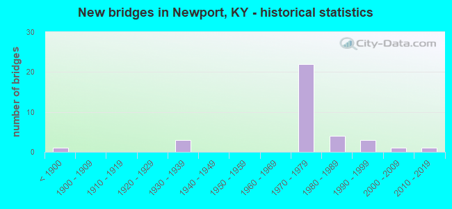
- New bridges - historical statistics
- 1Before 1900
- 31930-1939
- 221970-1979
- 41980-1989
- 31990-1999
- 12000-2009
- 12010-2019


- Bridge Condition - Deck
- 6.7%Very good
- 53.3%Good
- 33.3%Satisfactory
- 6.7%Fair

- Bridge Condition - Superstructure
- 13.3%Very good
- 33.3%Good
- 26.7%Satisfactory
- 26.7%Fair

- Bridge Condition - Substructure
- 6.7%Very good
- 20.0%Good
- 53.3%Satisfactory
- 13.3%Fair
- 6.7%Poor

- Bridge Condition - Channel
- 60.0%Very good
- 20.0%Good
- 20.0%Fair
Find on map >> Show street view
Structure Number: 19B00039L, Location: SBL DAN BEARD OVER OHIO R (Lat: 39.100000, Lng: -84.494167), Route carried "on" structure: Interstate 471, Year Built: 1976, Status: Open, Structure Length: 39.62m (129.99ft), Average Daily Traffic: 45,643 (year 2020), Truck Traffic: 3%, Average Future Daily Traffic: 48,837 (year 2040), Design Load: HS 20+Mod, Features Intersected: OHIO RIVER
Minimum Vertical Clearance: 30+ m (98+ ft), Kilometerpoint: 7.870, Lanes on structure: 4, Lanes under structure: 1, Base Highway Network: Yes, Owner: State Highway Agency, Approaching Roadway Width: 17.1m (56.1ft), Navigation Control: Yes ( Vertical Clearance: 23.8m (78.1ft), Horizontal Clearance: 30.4m (99.7ft)), Material/Design: Steel, Design/Construction: Arch - Thru, Number Of Spans In Main Unit: 1, Number Of Approach Spans: 2, Length of Maximum Span: 231.0m (757.9ft), Curb-To-Curb Width: 15.3m (50.2ft), Out-to-Out Width: 16.2m (53.1ft)
Condition: Deck: Satisfactory, Superstructure: Fair, Substructure: Satisfactory, Channel: Very good, Operating Rating: 60.1 metric tons, Method Used To Determine Operating Rating: Load Factor (LF), Inventory Rating: 35.9 metric tons, Method Used To Determine Inventory Rating: Load Factor (LF), Structural Evaluation: Somewhat better than minimum adequacy, Deck Geometry: High priority of replacement, Underclear: High priority of corrective action, Waterway Adequacy: Equal to present desirable criteria, Approach Roadway Alignment: Equal to present desirable criteria, Length Of Structure Improvement: 6.40m (21.00ft), Designated Inspection Frequency: Every 24 months, Critical Feature Inspection Frequency: Every 24 months, Underwater Inspection Frequency: Every 60 months, Inspection Date: September 2020, Critical Feature Inspection Date: September 2020, Underwater Inspection Date: August 2017, Bridge Improvement Cost: $8,661,000, Total Project Cost: $8,661,000, Deck Structure Type: Concrete Cast-file-Place, Wearing Surface/Protective System: Wearing Surface: Low Slump Concrete, Deck Protection: Epoxy Coated Reinforcing
Find on map >> Show street view
Structure Number: 19B00039R, Location: NBL DAN BEARD OVER OHIO R (Lat: 39.100278, Lng: -84.493889), Route carried "on" structure: Interstate 471, Year Built: 1976, Status: Open, Structure Length: 39.62m (129.99ft), Average Daily Traffic: 45,643 (year 2020), Truck Traffic: 3%, Average Future Daily Traffic: 48,837 (year 2040), Design Load: HS 20+Mod, Features Intersected: OHIO RIVER
Minimum Vertical Clearance: 30+ m (98+ ft), Kilometerpoint: 7.870, Lanes on structure: 4, Lanes under structure: 1, Base Highway Network: Yes, Owner: State Highway Agency, Approaching Roadway Width: 17.1m (56.1ft), Navigation Control: Yes ( Vertical Clearance: 23.8m (78.1ft), Horizontal Clearance: 30.4m (99.7ft)), Material/Design: Steel, Design/Construction: Arch - Thru, Number Of Spans In Main Unit: 1, Number Of Approach Spans: 2, Length of Maximum Span: 231.0m (757.9ft), Curb-To-Curb Width: 15.3m (50.2ft), Out-to-Out Width: 16.9m (55.4ft)
Condition: Deck: Satisfactory, Superstructure: Fair, Substructure: Satisfactory, Channel: Very good, Operating Rating: 60.1 metric tons, Method Used To Determine Operating Rating: Load Factor (LF), Inventory Rating: 35.9 metric tons, Method Used To Determine Inventory Rating: Load Factor (LF), Structural Evaluation: Somewhat better than minimum adequacy, Deck Geometry: High priority of replacement, Underclear: High priority of corrective action, Waterway Adequacy: Equal to present desirable criteria, Approach Roadway Alignment: Equal to present desirable criteria, Length Of Structure Improvement: 6.40m (21.00ft), Designated Inspection Frequency: Every 24 months, Critical Feature Inspection Frequency: Every 24 months, Underwater Inspection Frequency: Every 60 months, Inspection Date: September 2020, Critical Feature Inspection Date: September 2020, Underwater Inspection Date: August 2017, Bridge Improvement Cost: $8,986,000, Total Project Cost: $8,986,000, Deck Structure Type: Concrete Cast-file-Place, Wearing Surface/Protective System: Wearing Surface: Low Slump Concrete, Deck Protection: Epoxy Coated Reinforcing
Find on map >> Show street view
Structure Number: 19B00051N, Location: NB EXIT RAMP OVER KY1892 (Lat: 39.082500, Lng: -84.470556), Route carried "on" structure: Ramp Interstate 471, Year Built: 1977, Status: Open, Structure Length: 4.57m (14.99ft), Average Daily Traffic: 83,048 (year 2020), Truck Traffic: 5%, Average Future Daily Traffic: 88,861 (year 2040), Design Load: HS 20, Features Intersected: GRAND AVE (KY 1892)
Minimum Vertical Clearance: 30+ m (98+ ft), Kilometerpoint: 4.894, Lanes on structure: 2, Lanes under structure: 4, Owner: State Highway Agency, Approaching Roadway Width: 7.3m (24.0ft), Skew: 2 degrees, Material/Design: Steel, Design/Construction: Stringer/Multi-beam, Number Of Spans In Main Unit: 1, Length of Maximum Span: 45.7m (149.9ft), Curb-To-Curb Width: 7.5m (24.6ft), Out-to-Out Width: 8.7m (28.5ft)
Condition: Deck: Good, Superstructure: Good, Substructure: Satisfactory, Operating Rating: 75.6 metric tons, Method Used To Determine Operating Rating: Load Factor (LF), Inventory Rating: 45.4 metric tons, Method Used To Determine Inventory Rating: Load Factor (LF), Structural Evaluation: Equal to present minimum criteria, Deck Geometry: High priority of replacement, Underclear: Better than present minimum criteria, Approach Roadway Alignment: Better than present minimum criteria, Length Of Structure Improvement: 0.64m (2.10ft), Designated Inspection Frequency: Every 24 months, Inspection Date: August 2021, Bridge Improvement Cost: $726,000, Total Project Cost: $726,000, Deck Structure Type: Concrete Cast-file-Place, Wearing Surface/Protective System: Wearing Surface: Latex Concrete, Deck Protection: Epoxy Coated Reinforcing
Find on map >> Show street view
Structure Number: 19B00052L, Location: SBL OVR KY 1892 & RAMP E (Lat: 39.084722, Lng: -84.473056), Route carried "on" structure: Interstate 471, Year Built: 1977, Status: Open, Structure Length: 6.13m (20.11ft), Average Daily Traffic: 42,502 (year 2020), Truck Traffic: 5%, Average Future Daily Traffic: 45,477 (year 2040), Design Load: HS 20, Features Intersected: KY 1892-GRAND AVE & RMP
Minimum Vertical Clearance: 30+ m (98+ ft), Kilometerpoint: 5.217, Lanes on structure: 3, Lanes under structure: 5, Base Highway Network: Yes, Owner: State Highway Agency, Approaching Roadway Width: 17.1m (56.1ft), Skew: 14 degrees, Material/Design: Steel continuous, Design/Construction: Stringer/Multi-beam, Number Of Spans In Main Unit: 2, Length of Maximum Span: 46.3m (151.9ft), Curb-To-Curb Width: 17.1m (56.1ft), Out-to-Out Width: 18.3m (60.0ft)
Condition: Deck: Satisfactory, Superstructure: Satisfactory, Substructure: Fair, Operating Rating: 60.5 metric tons, Method Used To Determine Operating Rating: Load Factor (LF), Inventory Rating: 36.3 metric tons, Method Used To Determine Inventory Rating: Load Factor (LF), Structural Evaluation: Somewhat better than minimum adequacy, Deck Geometry: Equal to present minimum criteria, Underclear: Equal to present desirable criteria, Approach Roadway Alignment: Superior to present desirable criteria, Designated Inspection Frequency: Every 24 months, Inspection Date: August 2021, Deck Structure Type: Concrete Cast-file-Place, Wearing Surface/Protective System: Wearing Surface: Latex Concrete, Deck Protection: Epoxy Coated Reinforcing
Find on map >> Show street view
Structure Number: 19B00052R, Location: NBL OVR KY 1892 & RAMP E (Lat: 39.084722, Lng: -84.472778), Route carried "on" structure: Interstate 471, Year Built: 1977, Status: Open, Structure Length: 6.13m (20.11ft), Average Daily Traffic: 42,502 (year 2020), Truck Traffic: 5%, Average Future Daily Traffic: 45,477 (year 2040), Design Load: HS 20, Features Intersected: KY 1892-GRAND AVE &RAMP
Minimum Vertical Clearance: 30+ m (98+ ft), Kilometerpoint: 5.164, Lanes on structure: 3, Lanes under structure: 5, Base Highway Network: Yes, Owner: State Highway Agency, Approaching Roadway Width: 17.1m (56.1ft), Skew: 14 degrees, Material/Design: Steel continuous, Design/Construction: Stringer/Multi-beam, Number Of Spans In Main Unit: 2, Length of Maximum Span: 46.3m (151.9ft), Curb-To-Curb Width: 17.1m (56.1ft), Out-to-Out Width: 18.3m (60.0ft)
Condition: Deck: Good, Superstructure: Fair, Substructure: Fair, Operating Rating: 60.5 metric tons, Method Used To Determine Operating Rating: Load Factor (LF), Inventory Rating: 36.3 metric tons, Method Used To Determine Inventory Rating: Load Factor (LF), Structural Evaluation: Somewhat better than minimum adequacy, Deck Geometry: Equal to present minimum criteria, Underclear: Equal to present desirable criteria, Approach Roadway Alignment: Superior to present desirable criteria, Designated Inspection Frequency: Every 24 months, Inspection Date: August 2021, Deck Structure Type: Concrete Cast-file-Place, Wearing Surface/Protective System: Wearing Surface: Latex Concrete, Deck Protection: Epoxy Coated Reinforcing
Find on map >> Show street view
Structure Number: 19B00053L, Location: SBL .35 MI N OF KY 1892 (Lat: 39.088333, Lng: -84.475000), Route carried "on" structure: Interstate 471, Year Built: 1977, Status: Open, Structure Length: 6.64m (21.78ft), Average Daily Traffic: 42,502 (year 2020), Truck Traffic: 5%, Average Future Daily Traffic: 45,477 (year 2040), Design Load: HS 20, Features Intersected: CHESAPEAKE AVE
Minimum Vertical Clearance: 30+ m (98+ ft), Kilometerpoint: 5.650, Lanes on structure: 3, Lanes under structure: 1, Base Highway Network: Yes, Owner: State Highway Agency, Approaching Roadway Width: 17.1m (56.1ft), Skew: 10 degrees, Material/Design: Prestressed concrete continuous, Design/Construction: Stringer/Multi-beam, Number Of Spans In Main Unit: 3, Length of Maximum Span: 21.6m (70.9ft), Curb-To-Curb Width: 19.4m (63.6ft), Out-to-Out Width: 20.6m (67.6ft)
Condition: Deck: Good, Superstructure: Good, Substructure: Satisfactory, Operating Rating: 88.9 metric tons, Method Used To Determine Operating Rating: Load Factor (LF), Inventory Rating: 53.3 metric tons, Method Used To Determine Inventory Rating: Load Factor (LF), Structural Evaluation: Equal to present minimum criteria, Deck Geometry: Superior to present desirable criteria, Underclear: Superior to present desirable criteria, Approach Roadway Alignment: Equal to present minimum criteria, Length Of Structure Improvement: 0.66m (2.17ft), Designated Inspection Frequency: Every 24 months, Inspection Date: August 2021, Bridge Improvement Cost: $1,839,000, Total Project Cost: $1,839,000, Deck Structure Type: Concrete Cast-file-Place, Wearing Surface/Protective System: Wearing Surface: Latex Concrete, Deck Protection: Epoxy Coated Reinforcing
Find on map >> Show street view
Structure Number: 19B00053R, Location: NBL .35 MI N OF KY 1892 (Lat: 39.088611, Lng: -84.474722), Route carried "on" structure: Interstate 471, Year Built: 1977, Status: Open, Structure Length: 6.64m (21.78ft), Average Daily Traffic: 42,502 (year 2020), Truck Traffic: 5%, Average Future Daily Traffic: 45,477 (year 2040), Design Load: HS 20, Features Intersected: CHESAPEAKE AVE
Minimum Vertical Clearance: 30+ m (98+ ft), Kilometerpoint: 5.620, Lanes on structure: 3, Lanes under structure: 1, Base Highway Network: Yes, Owner: State Highway Agency, Approaching Roadway Width: 17.1m (56.1ft), Skew: 10 degrees, Material/Design: Prestressed concrete continuous, Design/Construction: Stringer/Multi-beam, Number Of Spans In Main Unit: 3, Length of Maximum Span: 21.6m (70.9ft), Curb-To-Curb Width: 19.4m (63.6ft), Out-to-Out Width: 20.6m (67.6ft)
Condition: Deck: Good, Superstructure: Good, Substructure: Satisfactory, Operating Rating: 88.9 metric tons, Method Used To Determine Operating Rating: Load Factor (LF), Inventory Rating: 53.3 metric tons, Method Used To Determine Inventory Rating: Load Factor (LF), Structural Evaluation: Equal to present minimum criteria, Deck Geometry: Superior to present desirable criteria, Underclear: Superior to present desirable criteria, Approach Roadway Alignment: Equal to present minimum criteria, Length Of Structure Improvement: 0.66m (2.17ft), Designated Inspection Frequency: Every 24 months, Inspection Date: August 2021, Bridge Improvement Cost: $1,839,000, Total Project Cost: $1,839,000, Deck Structure Type: Concrete Cast-file-Place, Wearing Surface/Protective System: Wearing Surface: Latex Concrete, Deck Protection: Epoxy Coated Reinforcing
Find on map >> Show street view
Structure Number: 19B00064N, Location: I-471 SB RAMP TO KY8 (Lat: 39.098333, Lng: -84.490833), Route carried "on" structure: Ramp Interstate 471, Year Built: 1988, Status: Open, Structure Length: 2.35m (7.71ft), Average Daily Traffic: 88,756 (year 2020), Truck Traffic: 7%, Average Future Daily Traffic: 94,968 (year 2040), Design Load: HS 20, Features Intersected: RAMP K
Minimum Vertical Clearance: 30+ m (98+ ft), Kilometerpoint: 7.522, Lanes on structure: 2, Lanes under structure: 1, Owner: State Highway Agency, Approaching Roadway Width: 9.1m (29.9ft), Skew: 5 degrees, Material/Design: Prestressed concrete, Design/Construction: Stringer/Multi-beam, Number Of Spans In Main Unit: 1, Length of Maximum Span: 21.9m (71.9ft), Curb-To-Curb Width: 7.9m (25.9ft), Out-to-Out Width: 8.9m (29.2ft)
Condition: Deck: Satisfactory, Superstructure: Good, Substructure: Good, Operating Rating: 59.0 metric tons, Method Used To Determine Operating Rating: Load Factor (LF), Inventory Rating: 35.4 metric tons, Method Used To Determine Inventory Rating: Load Factor (LF), Structural Evaluation: Better than present minimum criteria, Deck Geometry: High priority of replacement, Underclear: High priority of corrective action, Approach Roadway Alignment: Equal to present minimum criteria, Length Of Structure Improvement: 0.23m (0.75ft), Designated Inspection Frequency: Every 24 months, Inspection Date: August 2021, Bridge Improvement Cost: $282,000, Total Project Cost: $282,000, Deck Structure Type: Concrete Cast-file-Place, Wearing Surface/Protective System: Wearing Surface: Monolithic Concrete, Deck Protection: Epoxy Coated Reinforcing
Find on map >> Show street view
Structure Number: 19B00076N, Location: AT OHIO RIVER (Lat: 39.096111, Lng: -84.501389), Route carried "on" structure: US 27, Year Built: 1995, Status: Open, Structure Length: 70.05m (229.82ft), Average Daily Traffic: 12,632 (year 2017), Truck Traffic: 15%, Average Future Daily Traffic: 11,874 (year 2037), Design Load: HS 25 or greater, Features Intersected: OHIO RIVER
Minimum Vertical Clearance: 6.00m (19.69ft), Kilometerpoint: 36.342, Lanes on structure: 4, Lanes under structure: 6, Base Highway Network: Yes, Owner: State Highway Agency, Approaching Roadway Width: 18.6m (61.0ft), Skew: 10 degrees, Navigation Control: Yes ( Vertical Clearance: 22.2m (72.8ft), Horizontal Clearance: 30.4m (99.7ft)), Material/Design: Steel continuous, Design/Construction: Truss - Thru, Number Of Spans In Main Unit: 3, Number Of Approach Spans: 6, Length of Maximum Span: 259.1m (850.1ft), Curb or Sidewalk Widths: Left: 2.4m (7.9ft), Right: 2.4m (7.9ft), Curb-To-Curb Width: 18.3m (60.0ft), Out-to-Out Width: 19.3m (63.3ft)
Condition: Deck: Satisfactory, Superstructure: Satisfactory, Substructure: Satisfactory, Channel: Good, Operating Rating: 51.6 metric tons, Method Used To Determine Operating Rating: Load Factor (LF), Inventory Rating: 32.0 metric tons, Method Used To Determine Inventory Rating: Load Factor (LF), Structural Evaluation: Equal to present minimum criteria, Deck Geometry: Somewhat better than minimum adequacy, Underclear: Meets minimum limits, Waterway Adequacy: Superior to present desirable criteria, Approach Roadway Alignment: Equal to present minimum criteria, Designated Inspection Frequency: Every 24 months, Critical Feature Inspection Frequency: Every 24 months, Underwater Inspection Frequency: Every 60 months, Inspection Date: October 2020, Critical Feature Inspection Date: October 2020, Underwater Inspection Date: August 2017, Deck Structure Type: Concrete Cast-file-Place, Wearing Surface/Protective System: Wearing Surface: Monolithic Concrete, Deck Protection: Epoxy Coated Reinforcing
Find on map >> Show street view
Structure Number: 19B00082L, Location: SB DEP STRUC TO DAN BEARD (Lat: 39.098889, Lng: -84.491667), Route carried "on" structure: Interstate 471, Year Built: 1976, Status: Open, Structure Length: 13.32m (43.70ft), Average Daily Traffic: 44,378 (year 2020), Truck Traffic: 7%, Average Future Daily Traffic: 47,484 (year 2040), Design Load: HS 20+Mod, Features Intersected: KY 8
Minimum Vertical Clearance: 30+ m (98+ ft), Kilometerpoint: 7.619, Lanes on structure: 4, Lanes under structure: 6, Base Highway Network: Yes, Owner: State Highway Agency, Approaching Roadway Width: 17.1m (56.1ft), Skew: 20 degrees, Material/Design: Steel continuous, Design/Construction: Stringer/Multi-beam, Number Of Spans In Main Unit: 5, Length of Maximum Span: 34.1m (111.9ft), Curb or Sidewalk Widths: Left: 0.6m (2.0ft), Right: 0.6m (2.0ft), Curb-To-Curb Width: 15.2m (49.9ft), Out-to-Out Width: 21.8m (71.5ft)
Condition: Deck: Good, Superstructure: Satisfactory, Substructure: Satisfactory, Operating Rating: 66.2 metric tons, Method Used To Determine Operating Rating: Load Factor (LF), Inventory Rating: 39.7 metric tons, Method Used To Determine Inventory Rating: Load Factor (LF), Structural Evaluation: Equal to present minimum criteria, Deck Geometry: High priority of replacement, Underclear: High priority of corrective action, Approach Roadway Alignment: Equal to present minimum criteria, Designated Inspection Frequency: Every 24 months, Inspection Date: September 2020, Bridge Improvement Cost: $499,000, Total Project Cost: $499,000, Deck Structure Type: Concrete Cast-file-Place, Wearing Surface/Protective System: Wearing Surface: Latex Concrete, Deck Protection: Epoxy Coated Reinforcing
Find on map >> Show street view
Structure Number: 19B00082R, Location: NB APP SP TO D BEARD BR (Lat: 39.099167, Lng: -84.491667), Route carried "on" structure: Interstate 471, Year Built: 1976, Status: Open, Structure Length: 13.32m (43.70ft), Average Daily Traffic: 44,378 (year 2020), Truck Traffic: 7%, Average Future Daily Traffic: 47,484 (year 2040), Design Load: HS 20, Features Intersected: KY 8
Minimum Vertical Clearance: 30+ m (98+ ft), Kilometerpoint: 7.604, Lanes on structure: 4, Lanes under structure: 6, Base Highway Network: Yes, Owner: State Highway Agency, Approaching Roadway Width: 15.8m (51.8ft), Skew: 20 degrees, Material/Design: Steel continuous, Design/Construction: Stringer/Multi-beam, Number Of Spans In Main Unit: 5, Length of Maximum Span: 34.1m (111.9ft), Curb or Sidewalk Widths: Left: 0.6m (2.0ft), Right: 0.6m (2.0ft), Curb-To-Curb Width: 15.3m (50.2ft), Out-to-Out Width: 16.9m (55.4ft)
Condition: Deck: Good, Superstructure: Satisfactory, Substructure: Satisfactory, Operating Rating: 58.2 metric tons, Method Used To Determine Operating Rating: Load Factor (LF), Inventory Rating: 34.9 metric tons, Method Used To Determine Inventory Rating: Load Factor (LF), Structural Evaluation: Equal to present minimum criteria, Deck Geometry: High priority of replacement, Underclear: High priority of corrective action, Approach Roadway Alignment: Better than present minimum criteria, Designated Inspection Frequency: Every 24 months, Inspection Date: September 2020, Bridge Improvement Cost: $499,000, Total Project Cost: $499,000, Deck Structure Type: Concrete Cast-file-Place, Wearing Surface/Protective System: Wearing Surface: Low Slump Concrete, Deck Protection: Epoxy Coated Reinforcing
Find on map >> Show street view
Structure Number: 19B00084N, Location: 10TH ST OVR CSX RR-NWPRT (Lat: 39.090000, Lng: -84.483889), Route carried "on" structure: State highway 1120, Year Built: 2004, Status: Open, Structure Length: 2.50m (8.20ft), Average Daily Traffic: 10,748 (year 2020), Truck Traffic: 9%, Average Future Daily Traffic: 10,103 (year 2040), Design Load: HS 25 or greater, Features Intersected: CSX RAILROAD
Minimum Vertical Clearance: 30+ m (98+ ft), Kilometerpoint: 1.801, Lanes on structure: 2, Base Highway Network: Yes, Owner: State Highway Agency, Approaching Roadway Width: 19.1m (62.7ft), Skew: 5 degrees, Material/Design: Prestressed concrete, Design/Construction: Box Beam or Girders - Single/Spread, Number Of Spans In Main Unit: 1, Length of Maximum Span: 25.0m (82.0ft), Curb or Sidewalk Widths: Left: 1.8m (5.9ft), Right: 1.8m (5.9ft), Curb-To-Curb Width: 15.4m (50.5ft), Out-to-Out Width: 19.2m (63.0ft)
Condition: Deck: Good, Superstructure: Very good, Substructure: Good, Operating Rating: 83.6 metric tons, Method Used To Determine Operating Rating: Load Factor (LF), Inventory Rating: 50.1 metric tons, Method Used To Determine Inventory Rating: Load Factor (LF), Structural Evaluation: Better than present minimum criteria, Deck Geometry: Superior to present desirable criteria, Underclear: Equal to present desirable criteria, Approach Roadway Alignment: Equal to present desirable criteria, Designated Inspection Frequency: Every 24 months, Inspection Date: August 2021, Deck Structure Type: Concrete Cast-file-Place, Wearing Surface/Protective System: Wearing Surface: Monolithic Concrete, Deck Protection: Epoxy Coated Reinforcing
Find on map >> Show street view
Structure Number: 19C00057N, Location: 200' EAST JCT KY 9 (Lat: 39.081389, Lng: -84.491667), Route carried "on" structure: City street 1204, Year Built: 1989, Status: Posted for load, Structure Length: 24.51m (80.41ft), Average Daily Traffic: 1,609 (year 2006), Average Future Daily Traffic: 3,215 (year 2026), Design Load: HS 25 or greater, Features Intersected: CSX RAILROAD
Minimum Vertical Clearance: 30+ m (98+ ft), Kilometerpoint: 0.126, Lanes on structure: 2, Owner: County Highway Agency, Approaching Roadway Width: 7.9m (25.9ft), Material/Design: Steel continuous, Design/Construction: Stringer/Multi-beam, Number Of Spans In Main Unit: 4, Number Of Approach Spans: 5, Length of Maximum Span: 40.5m (132.9ft), Curb or Sidewalk Widths: Left: 0.5m (1.6ft), Right: 1.8m (5.9ft), Curb-To-Curb Width: 7.9m (25.9ft), Out-to-Out Width: 10.3m (33.8ft)
Condition: Deck: Good, Superstructure: Good, Substructure: Good, Operating Rating: 37.8 metric tons, Method Used To Determine Operating Rating: Load Factor (LF), Inventory Rating: 22.6 metric tons, Method Used To Determine Inventory Rating: Load Factor (LF), Structural Evaluation: Equal to present minimum criteria, Deck Geometry: Meets minimum limits, Underclear: Equal to present minimum criteria, Approach Roadway Alignment: Better than present minimum criteria, Bridge Posting: Required (Relationship of Operating Rating to Maximum Legal Load: 10.0 - 19.9% below), Designated Inspection Frequency: Every 24 months, Inspection Date: January 2020, Deck Structure Type: Concrete Cast-file-Place, Wearing Surface/Protective System: Wearing Surface: Monolithic Concrete, Deck Protection: Epoxy Coated Reinforcing
Find on map >> Show street view
Structure Number: 19C00060N, Location: AT JCT WATERWORKS ROAD (Lat: 39.090556, Lng: -84.462500), Route carried "on" structure: City street 1212, Year Built: 1983, Status: Posted for load, Structure Length: 1.40m (4.59ft), Average Daily Traffic: 167 (year 2006), Average Future Daily Traffic: 334 (year 2026), Design Load: HS 25 or greater, Features Intersected: TAYLOR CREEK, Facility Carried by Structure: CS-4053
Minimum Vertical Clearance: 30+ m (98+ ft), Kilometerpoint: 0.013, Lanes on structure: 2, Owner: County Highway Agency, Approaching Roadway Width: 7.3m (24.0ft), Material/Design: Prestressed concrete, Design/Construction: Box Beam or Girders - Multiple, Number Of Spans In Main Unit: 1, Length of Maximum Span: 13.1m (43.0ft), Curb or Sidewalk Widths: Left: 0.2m (0.7ft), Right: 0.2m (0.7ft), Curb-To-Curb Width: 7.1m (23.3ft), Out-to-Out Width: 7.3m (24.0ft)
Condition: Deck: Fair, Superstructure: Fair, Substructure: Poor, Channel: Fair, Operating Rating: 13.6 metric tons, Method Used To Determine Operating Rating: Field evaluation and documented engineering judgment, Inventory Rating: 13.6 metric tons, Method Used To Determine Inventory Rating: Field evaluation and documented engineering judgment, Structural Evaluation: Meets minimum limits, Deck Geometry: Meets minimum limits, Waterway Adequacy: Better than present minimum criteria, Approach Roadway Alignment: Somewhat better than minimum adequacy, Bridge Posting: Required (Relationship of Operating Rating to Maximum Legal Load: > 39.9% below), Designated Inspection Frequency: Every 12 months, Other Special Inspection Frequency: Every 1 months, Inspection Date: January 2021, Other Special Inspection Date: December 2021, Deck Structure Type: Concrete Precast Panels, Wearing Surface/Protective System: Wearing Surface: Bituminous, Deck Protection: Epoxy Coated Reinforcing
Find on map >> Show street view
Structure Number: 19C00079N, Location: .9 M West of KY 1120 (Lat: 39.092500, Lng: -84.463611), Route carried "on" structure: City street 1193, Year Built: 2016, Status: Open, Structure Length: 1.11m (3.64ft), Average Daily Traffic: 1,609 (year 2017), Average Future Daily Traffic: 3,215 (year 2037), Design Load: Greater than HL93, Features Intersected: Taylor Creek, Facility Carried by Structure: Waterworks Rd.
Minimum Vertical Clearance: 30+ m (98+ ft), Kilometerpoint: 1.267, Lanes on structure: 2, Owner: City or Municipal Highway Agency, Approaching Roadway Width: 6.1m (20.0ft), Skew: 4 degrees, Material/Design: Concrete, Design/Construction: Box Beam or Girders - Single/Spread, Number Of Spans In Main Unit: 1, Length of Maximum Span: 9.1m (29.9ft), Curb-To-Curb Width: 10.4m (34.1ft), Out-to-Out Width: 11.6m (38.1ft)
Condition: Deck: Very good, Superstructure: Very good, Substructure: Very good, Channel: Very good, Operating Rating: 70.6 metric tons, Method Used To Determine Operating Rating: Load and Resistance Factor Rating (LRFR) rating reported by rating factor(RF) method using HL-93 loadings, Inventory Rating: 54.4 metric tons, Method Used To Determine Inventory Rating: Load and Resistance Factor Rating (LRFR) rating reported by rating factor(RF) method using HL-93 loadings, Structural Evaluation: Equal to present desirable criteria, Deck Geometry: Equal to present minimum criteria, Waterway Adequacy: Somewhat better than minimum adequacy, Approach Roadway Alignment: Equal to present minimum criteria, Designated Inspection Frequency: Every 24 months, Inspection Date: January 2020, Deck Structure Type: Concrete Cast-file-Place, Wearing Surface/Protective System: Wearing Surface: Monolithic Concrete, Deck Protection: Epoxy Coated Reinforcing
Find on map >> Show street view
Structure Number: 19B00039L, Location: SBL DAN BEARD OVER OHIO R (Lat: 39.100000, Lng: -84.494167), Route carried "under" structure: City street 1000, Year Built: 1976, Structure Length: 0. m, Features Intersected: OHIO RIVER, Facility Carried by Structure: I-471 NC
Minimum Vertical Clearance: 7.59m (24.90ft), Kilometerpoint: 0.484, Lanes on structure: 4, Lanes under structure: 1, Material/Design: Steel, Design/Construction: Arch - Thru, Length of Maximum Span: 231.0m (757.9ft)
Find on map >> Show street view
Structure Number: 19B00039R, Location: NBL DAN BEARD OVER OHIO R (Lat: 39.100278, Lng: -84.493889), Route carried "under" structure: City street 1000, Year Built: 1976, Structure Length: 0. m, Features Intersected: OHIO RIVER, Facility Carried by Structure: I-471
Minimum Vertical Clearance: 30+ m (98+ ft), Kilometerpoint: 0.459, Lanes on structure: 4, Lanes under structure: 1, Material/Design: Steel, Design/Construction: Arch - Thru, Length of Maximum Span: 231.0m (757.9ft)
Find on map >> Show street view
Structure Number: 19B00051N, Location: NB EXIT RAMP OVER KY1892 (Lat: 39.082500, Lng: -84.470556), Route carried "under" structure: State highway 1892, Year Built: 1977, Structure Length: 0. m, Average Daily Traffic: 10,205 (year 2020), Truck Traffic: 4%, Features Intersected: GRAND AVE (KY 1892), Facility Carried by Structure: I-471
Minimum Vertical Clearance: 5.69m (18.67ft), Kilometerpoint: 2.680, Lanes on structure: 2, Lanes under structure: 4, Material/Design: Steel, Design/Construction: Stringer/Multi-beam, Length of Maximum Span: 45.7m (149.9ft)
Find on map >> Show street view
Structure Number: 19B00052L, Location: SBL OVR KY 1892 & RAMP E (Lat: 39.084722, Lng: -84.473056), Route carried "under" structure: Ramp Interstate 471, Year Built: 1977, Structure Length: 0. m, Average Daily Traffic: 85,003 (year 2020), Truck Traffic: 5%, Features Intersected: KY 1892-GRAND AVE & RMP
Minimum Vertical Clearance: 30+ m (98+ ft), Kilometerpoint: 5.195, Lanes on structure: 3, Lanes under structure: 1, Material/Design: Steel continuous, Design/Construction: Stringer/Multi-beam, Length of Maximum Span: 46.3m (151.9ft)
Find on map >> Show street view
Structure Number: 19B00052L, Location: SBL OVR KY 1892 & RAMP E (Lat: 39.084722, Lng: -84.473056), Route carried "under" structure: State highway 1892, Year Built: 1977, Structure Length: 0. m, Average Daily Traffic: 10,205 (year 2020), Truck Traffic: 4%, Features Intersected: KY 1892-GRAND AVE & RMP, Facility Carried by Structure: I-471 NC
Minimum Vertical Clearance: 30+ m (98+ ft), Kilometerpoint: 3.048, Lanes on structure: 3, Lanes under structure: 4, Material/Design: Steel continuous, Design/Construction: Stringer/Multi-beam, Length of Maximum Span: 46.3m (151.9ft)
Find on map >> Show street view
Structure Number: 19B00052R, Location: NBL OVR KY 1892 & RAMP E (Lat: 39.084722, Lng: -84.472778), Route carried "under" structure: State highway 1892, Year Built: 1977, Structure Length: 0. m, Average Daily Traffic: 10,205 (year 2020), Truck Traffic: 4%, Features Intersected: KY 1892-GRAND AVE &RAMP, Facility Carried by Structure: I-471
Minimum Vertical Clearance: 30+ m (98+ ft), Kilometerpoint: 3.018, Lanes on structure: 3, Lanes under structure: 4, Material/Design: Steel continuous, Design/Construction: Stringer/Multi-beam, Length of Maximum Span: 46.3m (151.9ft)
Find on map >> Show street view
Structure Number: 19B00052R, Location: NBL OVR KY 1892 & RAMP E (Lat: 39.084722, Lng: -84.472778), Route carried "under" structure: Ramp Interstate 471, Year Built: 1977, Structure Length: 0. m, Average Daily Traffic: 85,003 (year 2020), Truck Traffic: 5%, Features Intersected: KY 1892-GRAND AVE &RAMP
Minimum Vertical Clearance: 30+ m (98+ ft), Kilometerpoint: 5.187, Lanes on structure: 3, Lanes under structure: 1, Material/Design: Steel continuous, Design/Construction: Stringer/Multi-beam, Length of Maximum Span: 46.3m (151.9ft)
Find on map >> Show street view
Structure Number: 19B00053L, Location: SBL .35 MI N OF KY 1892 (Lat: 39.088333, Lng: -84.475000), Route carried "under" structure: City street 1189, Year Built: 1977, Structure Length: 0. m, Average Daily Traffic: 273 (year 2006), Features Intersected: CHESAPEAKE AVE, Facility Carried by Structure: I-471 NC
Minimum Vertical Clearance: 30+ m (98+ ft), Kilometerpoint: 0.269, Lanes on structure: 3, Lanes under structure: 1, Material/Design: Prestressed concrete continuous, Design/Construction: Stringer/Multi-beam, Length of Maximum Span: 21.6m (70.9ft)
Find on map >> Show street view
Structure Number: 19B00053R, Location: NBL .35 MI N OF KY 1892 (Lat: 39.088611, Lng: -84.474722), Route carried "under" structure: City street 1189, Year Built: 1977, Structure Length: 0. m, Average Daily Traffic: 273 (year 2006), Features Intersected: CHESAPEAKE AVE, Facility Carried by Structure: I-471
Minimum Vertical Clearance: 30+ m (98+ ft), Kilometerpoint: 0.248, Lanes on structure: 3, Lanes under structure: 1, Material/Design: Prestressed concrete continuous, Design/Construction: Stringer/Multi-beam, Length of Maximum Span: 21.6m (70.9ft)
Find on map >> Show street view
Structure Number: 19B00064N, Location: I-471 SB RAMP TO KY8 (Lat: 39.098333, Lng: -84.490833), Route carried "under" structure: Ramp Interstate 471, Year Built: 1988, Structure Length: 0. m, Average Daily Traffic: 88,756 (year 2020), Truck Traffic: 7%, Features Intersected: RAMP K
Minimum Vertical Clearance: 7.16m (23.49ft), Kilometerpoint: 7.522, Lanes on structure: 2, Lanes under structure: 1, Material/Design: Prestressed concrete, Design/Construction: Stringer/Multi-beam, Length of Maximum Span: 21.9m (71.9ft)
Find on map >> Show street view
Structure Number: 19B00076N, Location: AT OHIO RIVER (Lat: 39.096111, Lng: -84.501389), Route carried "under" structure: City street 1002, Year Built: 1995, Structure Length: 0. m, Features Intersected: OHIO RIVER, Facility Carried by Structure: US-27
Minimum Vertical Clearance: 30+ m (98+ ft), Kilometerpoint: 0.076, Lanes on structure: 4, Lanes under structure: 4, Material/Design: Steel continuous, Design/Construction: Truss - Thru, Length of Maximum Span: 259.1m (850.1ft)
Find on map >> Show street view
Structure Number: 19B00076N, Location: AT OHIO RIVER (Lat: 39.096111, Lng: -84.501389), Route carried "under" structure: City street 1000, Year Built: 1995, Structure Length: 0. m, Features Intersected: OHIO RIVER, Facility Carried by Structure: US-27
Minimum Vertical Clearance: 30+ m (98+ ft), Kilometerpoint: 1.310, Lanes on structure: 4, Lanes under structure: 2, Material/Design: Steel continuous, Design/Construction: Truss - Thru, Length of Maximum Span: 259.1m (850.1ft)
Find on map >> Show street view
Structure Number: 19B00082L, Location: SB DEP STRUC TO DAN BEARD (Lat: 39.098889, Lng: -84.491667), Route carried "under" structure: Business State highway 8, Year Built: 1976, Structure Length: 0. m, Average Daily Traffic: 19,390 (year 2017), Truck Traffic: 9%, Features Intersected: KY 8, Facility Carried by Structure: I-471 NC
Minimum Vertical Clearance: 30+ m (98+ ft), Kilometerpoint: 0.832, Lanes on structure: 4, Lanes under structure: 4, Material/Design: Steel continuous, Design/Construction: Stringer/Multi-beam, Length of Maximum Span: 34.1m (111.9ft)
Find on map >> Show street view
Structure Number: 19B00082L, Location: SB DEP STRUC TO DAN BEARD (Lat: 39.098889, Lng: -84.491667), Route carried "under" structure: City street 1000, Year Built: 1976, Structure Length: 0. m, Features Intersected: KY 8, Facility Carried by Structure: I-471 NC
Minimum Vertical Clearance: 30+ m (98+ ft), Kilometerpoint: 0.484, Lanes on structure: 4, Lanes under structure: 2, Material/Design: Steel continuous, Design/Construction: Stringer/Multi-beam, Length of Maximum Span: 34.1m (111.9ft)
Find on map >> Show street view
Structure Number: 19B00082R, Location: NB APP SP TO D BEARD BR (Lat: 39.099167, Lng: -84.491667), Route carried "under" structure: City street 1000, Year Built: 1976, Structure Length: 0. m, Features Intersected: KY 8, Facility Carried by Structure: I-471
Minimum Vertical Clearance: 30+ m (98+ ft), Kilometerpoint: 0.457, Lanes on structure: 4, Lanes under structure: 2, Material/Design: Steel continuous, Design/Construction: Stringer/Multi-beam, Length of Maximum Span: 34.1m (111.9ft)
Find on map >> Show street view
Structure Number: 19B00082R, Location: NB APP SP TO D BEARD BR (Lat: 39.099167, Lng: -84.491667), Route carried "under" structure: Business State highway 8, Year Built: 1976, Structure Length: 0. m, Average Daily Traffic: 19,390 (year 2017), Truck Traffic: 9%, Features Intersected: KY 8, Facility Carried by Structure: I-471
Minimum Vertical Clearance: 30+ m (98+ ft), Kilometerpoint: 0.875, Lanes on structure: 4, Lanes under structure: 4, Material/Design: Steel continuous, Design/Construction: Stringer/Multi-beam, Length of Maximum Span: 34.1m (111.9ft)
Find on map >> Show street view
Structure Number: 19R00602N, Location: C&ORR OVR KY 9 SW-12TH ST (Lat: 39.078056, Lng: -84.496111), Route carried "under" structure: State highway 9, Year Built: 1930, Structure Length: 0. m, Average Daily Traffic: 7,794 (year 2015), Truck Traffic: 5%, Features Intersected: CSX RR OVER K9 & LICKNG
Minimum Vertical Clearance: 4.11m (13.48ft), Kilometerpoint: 35.262, Lanes under structure: 4, Material/Design: Steel, Design/Construction: Stringer/Multi-beam, Length of Maximum Span: 29.9m (98.1ft)
Find on map >> Show street view
Structure Number: 19R00604N, Location: C&ORR OVR US27 N-12TH ST (Lat: 39.085833, Lng: -84.486944), Route carried "under" structure: US 27, Year Built: 1935, Structure Length: 0. m, Average Daily Traffic: 14,818 (year 2020), Truck Traffic: 27%, Features Intersected: CSX RAILROAD
Minimum Vertical Clearance: 4.37m (14.34ft), Kilometerpoint: 34.480, Lanes under structure: 4, Material/Design: Steel, Design/Construction: Stringer/Multi-beam, Length of Maximum Span: 14.9m (48.9ft)
Find on map >> Show street view
Structure Number: 19X00001N, Location: L&NRR OVR US27 S-11TH ST (Lat: 39.085556, Lng: -84.486667), Route carried "under" structure: US 27, Year Built: 1935, Structure Length: 0. m, Average Daily Traffic: 14,818 (year 2020), Truck Traffic: 27%, Features Intersected: US-27, Facility Carried by Structure: CSX RAILROAD
Minimum Vertical Clearance: 4.22m (13.85ft), Kilometerpoint: 34.446, Lanes under structure: 4, Material/Design: Steel, Design/Construction: Stringer/Multi-beam, Length of Maximum Span: 19.8m (65.0ft)
Find on map >> Show street view
Structure Number: 19X00003N, Location: PURPLE BR OVER RVBOAT ROW (Lat: 39.096111, Lng: -84.496111), Route carried "under" structure: City street 1000, Year Built: 1872, Structure Length: 0. m, Features Intersected: RIVERBOAT ROW RD., Facility Carried by Structure: PEDESTRIAN WALKWAY
Minimum Vertical Clearance: 6.98m (22.90ft), Kilometerpoint: 0.935, Lanes under structure: 1, Material/Design: Steel, Design/Construction: Truss - Thru, Length of Maximum Span: 59.4m (194.9ft)