Bridge Statistics for Newport Beach, California (CA)
Condition, Traffic, Stress, Structural Evaluation, Project Costs
- National Bridge Inventory (NBI) Statistics
- 41Number of bridges
- 1,043ft / 318mTotal length
- $146,000Total costs
- 1,609,742Total average daily traffic
- 31,380Total average daily truck traffic
- National Bridge Inventory (NBI) Registered Bridges for Newport Beach
- No street view available for this location
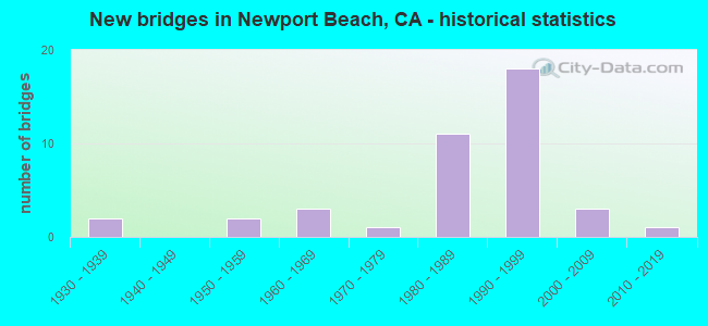
- New bridges - historical statistics
- 21930-1939
- 21950-1959
- 31960-1969
- 11970-1979
- 111980-1989
- 181990-1999
- 32000-2009
- 12010-2019

- Reconstructed bridges - Historical Statistics
- 11960-1969
- 31970-1979
- 01980-1989
- 31990-1999
- 22000-2009


- Bridge Condition - Deck
- 50.0%Good
- 50.0%Fair

- Bridge Condition - Superstructure
- 61.5%Good
- 34.6%Fair
- 3.8%Poor

- Bridge Condition - Substructure
- 50.0%Good
- 50.0%Fair

- Bridge Condition - Channel
- 31.8%Excellent
- 54.5%Very good
- 4.5%Satisfactory
- 9.1%Fair
Find on map >> Show street view
Structure Number: 55 0031, Location: 12-ORA-005-22.83-IRVN (Lat: 33.663267, Lng: -117.749508), Route carried "on" structure: Interstate 5, Year Built: 1958, Year Reconstructed: 1969, Status: Open, Structure Length: 1.01m (3.31ft), Average Daily Traffic: 315,000 (year 2019), Truck Traffic: 5%, Average Future Daily Traffic: 325,000 (year 2038), Features Intersected: BEE CANYON
Minimum Vertical Clearance: 30+ m (98+ ft), Kilometerpoint: 22.830, Lanes on structure: 10, Base Highway Network: Yes (, Subroute: 1), Owner: State Highway Agency, Approaching Roadway Width: 72.5m (237.9ft), Skew: 21 degrees, Material/Design: Concrete continuous, Design/Construction: Culvert, Number Of Spans In Main Unit: 3, Length of Maximum Span: 3.0m (9.8ft), Curb-To-Curb Width: 72.5m (237.9ft), Out-to-Out Width: 73.5m (241.1ft)
Condition: Channel: Very good, Culverts: Good, Operating Rating: 54.1 metric tons, Method Used To Determine Operating Rating: Field evaluation and documented engineering judgment, Inventory Rating: 32.4 metric tons, Method Used To Determine Inventory Rating: Field evaluation and documented engineering judgment, Structural Evaluation: Better than present minimum criteria, Deck Geometry: Superior to present desirable criteria, Waterway Adequacy: Equal to present desirable criteria, Approach Roadway Alignment: Equal to present desirable criteria, Designated Inspection Frequency: Every 24 months, Inspection Date: November 2020
Find on map >> Show street view
Structure Number: 55 0035, Location: 12-ORA-055-0.18-NPTB (Lat: 33.619736, Lng: -117.929642), Route carried "on" structure: State highway 55, Year Built: 1936, Year Reconstructed: 1999, Status: Open, Structure Length: 6.28m (20.60ft), Average Daily Traffic: 47,000 (year 2011), Truck Traffic: 1%, Average Future Daily Traffic: 58,281 (year 2044), Design Load: HS 20, Features Intersected: NEWPORT BEACH CHANNEL
Minimum Vertical Clearance: 30+ m (98+ ft), Kilometerpoint: 0.180, Lanes on structure: 6, Base Highway Network: Yes (, Subroute: 1), Owner: State Highway Agency, Approaching Roadway Width: 27.2m (89.2ft), Skew: 31 degrees, Navigation Control: Yes ( Vertical Clearance: 2.7m (8.9ft), Horizontal Clearance: 12.8m (42.0ft)), Material/Design: Prestressed concrete, Design/Construction: Girder and Floorbeam System, Number Of Spans In Main Unit: 5, Length of Maximum Span: 14.0m (45.9ft), Curb or Sidewalk Widths: Left: 3.6m (11.8ft), Right: 3.6m (11.8ft), Curb-To-Curb Width: 27.2m (89.2ft), Out-to-Out Width: 37.9m (124.3ft)
Condition: Deck: Good, Superstructure: Good, Substructure: Fair, Channel: Very good, Operating Rating: 40.8 metric tons, Method Used To Determine Operating Rating: Load Factor (LF), Inventory Rating: 25.3 metric tons, Method Used To Determine Inventory Rating: Load Factor (LF), Structural Evaluation: Somewhat better than minimum adequacy, Deck Geometry: Equal to present minimum criteria, Waterway Adequacy: Equal to present desirable criteria, Approach Roadway Alignment: Equal to present desirable criteria, Designated Inspection Frequency: Every 24 months, Underwater Inspection Frequency: Every 60 months, Inspection Date: January 2022, Underwater Inspection Date: June 2019, Deck Structure Type: Concrete Cast-file-Place
Find on map >> Show street view
Structure Number: 55 0531, Location: 12-ORA-073-24.78-NPTB (Lat: 33.655058, Lng: -117.865056), Route carried "on" structure: City street M025, Year Built: 1985, Year Reconstructed: 2012, Status: Open, Structure Length: 8.02m (26.31ft), Average Daily Traffic: 20,000 (year 2011), Truck Traffic: 1%, Average Future Daily Traffic: 22,000 (year 2038), Design Load: HS 20+Mod, Features Intersected: STATE ROUTE 73, Facility Carried by Structure: JAMBOREE ROAD
Minimum Vertical Clearance: 30+ m (98+ ft), Kilometerpoint: 0.000, Lanes on structure: 10, Lanes under structure: 9, Owner: State Highway Agency, Approaching Roadway Width: 32.3m (106.0ft), Material/Design: Prestressed concrete continuous, Design/Construction: Box Beam or Girders - Multiple, Number Of Spans In Main Unit: 2, Length of Maximum Span: 44.5m (146.0ft), Curb or Sidewalk Widths: Left: 2.4m (7.9ft), Right: 0.0m, Curb-To-Curb Width: 32.3m (106.0ft), Out-to-Out Width: 42.3m (138.8ft)
Condition: Deck: Good, Superstructure: Fair, Substructure: Fair, Operating Rating: 54.1 metric tons, Method Used To Determine Operating Rating: Assigned rating based on Load Factor Design (LFD) reported in metric tons, Inventory Rating: 32.4 metric tons, Method Used To Determine Inventory Rating: Assigned rating based on Load Factor Design (LFD) reported in metric tons, Structural Evaluation: Somewhat better than minimum adequacy, Deck Geometry: High priority of replacement, Underclear: High priority of corrective action, Approach Roadway Alignment: Equal to present desirable criteria, Designated Inspection Frequency: Every 24 months, Inspection Date: May 2020, Deck Structure Type: Concrete Cast-file-Place
Find on map >> Show street view
Structure Number: 55 0533, Location: 12-ORA-073-R25.58-NPTB (Lat: 33.662008, Lng: -117.875161), Route carried "on" structure: City street M209, Year Built: 1985, Year Reconstructed: 1990, Status: Open, Structure Length: 8.35m (27.40ft), Average Daily Traffic: 10,000 (year 2011), Truck Traffic: 1%, Average Future Daily Traffic: 11,000 (year 2038), Design Load: HS 20+Mod, Features Intersected: STATE ROUTE 73, Facility Carried by Structure: CAMPUS DRIVE
Minimum Vertical Clearance: 30+ m (98+ ft), Kilometerpoint: 0.000, Lanes on structure: 8, Lanes under structure: 7, Owner: State Highway Agency, Approaching Roadway Width: 31.7m (104.0ft), Material/Design: Prestressed concrete continuous, Design/Construction: Box Beam or Girders - Multiple, Number Of Spans In Main Unit: 2, Length of Maximum Span: 41.8m (137.1ft), Curb or Sidewalk Widths: Left: 1.5m (4.9ft), Right: 1.5m (4.9ft), Curb-To-Curb Width: 31.7m (104.0ft), Out-to-Out Width: 35.4m (116.1ft)
Condition: Deck: Good, Superstructure: Good, Substructure: Fair, Operating Rating: 54.1 metric tons, Method Used To Determine Operating Rating: Assigned rating based on Load Factor Design (LFD) reported in metric tons, Inventory Rating: 32.4 metric tons, Method Used To Determine Inventory Rating: Assigned rating based on Load Factor Design (LFD) reported in metric tons, Structural Evaluation: Somewhat better than minimum adequacy, Deck Geometry: Somewhat better than minimum adequacy, Underclear: High priority of corrective action, Approach Roadway Alignment: Equal to present desirable criteria, Designated Inspection Frequency: Every 24 months, Inspection Date: May 2020, Deck Structure Type: Concrete Cast-file-Place
Find on map >> Show street view
Structure Number: 55 0614, Location: 12-ORA-001-R18.22-NPTB (Lat: 33.616789, Lng: -117.903350), Route carried "on" structure: State highway 1, Year Built: 1981, Status: Open, Structure Length: 25.60m (83.99ft), Average Daily Traffic: 51,000 (year 2012), Average Future Daily Traffic: 68,226 (year 2040), Design Load: HS 20+Mod, Features Intersected: N ARM NEWPORT BAY
Minimum Vertical Clearance: 30+ m (98+ ft), Kilometerpoint: 18.220, Lanes on structure: 7, Base Highway Network: Yes (, Subroute: 1), Owner: State Highway Agency, Approaching Roadway Width: 29.9m (98.1ft), Skew: 9 degrees, Navigation Control: Yes ( Vertical Clearance: 6.0m (19.7ft), Horizontal Clearance: 30.0m (98.4ft)), Material/Design: Prestressed concrete continuous, Design/Construction: Box Beam or Girders - Multiple, Number Of Spans In Main Unit: 8, Length of Maximum Span: 36.6m (120.1ft), Curb or Sidewalk Widths: Left: 2.4m (7.9ft), Right: 2.4m (7.9ft), Curb-To-Curb Width: 29.9m (98.1ft), Out-to-Out Width: 35.4m (116.1ft)
Condition: Deck: Good, Superstructure: Good, Substructure: Fair, Channel: Excellent, Operating Rating: 54.1 metric tons, Method Used To Determine Operating Rating: Assigned rating based on Load Factor Design (LFD) reported in metric tons, Inventory Rating: 32.4 metric tons, Method Used To Determine Inventory Rating: Assigned rating based on Load Factor Design (LFD) reported in metric tons, Structural Evaluation: Somewhat better than minimum adequacy, Deck Geometry: Equal to present minimum criteria, Waterway Adequacy: Equal to present desirable criteria, Approach Roadway Alignment: Equal to present desirable criteria, Designated Inspection Frequency: Every 24 months, Underwater Inspection Frequency: Every 60 months, Inspection Date: June 2021, Underwater Inspection Date: June 2019, Deck Structure Type: Concrete Cast-file-Place
Find on map >> Show street view
Structure Number: 55 0636, Location: 12-ORA-073-R25.46-NPTB (Lat: 33.660869, Lng: -117.873378), Route carried "on" structure: City street , Year Built: 1985, Year Reconstructed: 1998, Status: Open, Structure Length: 8.12m (26.64ft), Average Daily Traffic: 10,000 (year 2011), Truck Traffic: 1%, Average Future Daily Traffic: 11,000 (year 2038), Design Load: HS 20+Mod, Features Intersected: STATE ROUTE 73, Facility Carried by Structure: BIRCH ST
Minimum Vertical Clearance: 30+ m (98+ ft), Kilometerpoint: 0.000, Lanes on structure: 7, Lanes under structure: 7, Owner: State Highway Agency, Approaching Roadway Width: 28.6m (93.8ft), Material/Design: Prestressed concrete continuous, Design/Construction: Box Beam or Girders - Multiple, Number Of Spans In Main Unit: 2, Length of Maximum Span: 40.5m (132.9ft), Curb or Sidewalk Widths: Left: 1.5m (4.9ft), Right: 1.5m (4.9ft), Curb-To-Curb Width: 28.6m (93.8ft), Out-to-Out Width: 32.8m (107.6ft)
Condition: Deck: Good, Superstructure: Good, Substructure: Fair, Operating Rating: 54.1 metric tons, Method Used To Determine Operating Rating: Assigned rating based on Load Factor Design (LFD) reported in metric tons, Inventory Rating: 32.4 metric tons, Method Used To Determine Inventory Rating: Assigned rating based on Load Factor Design (LFD) reported in metric tons, Structural Evaluation: Somewhat better than minimum adequacy, Deck Geometry: Somewhat better than minimum adequacy, Underclear: High priority of corrective action, Approach Roadway Alignment: Equal to present desirable criteria, Designated Inspection Frequency: Every 24 months, Inspection Date: May 2020, Deck Structure Type: Concrete Cast-file-Place
Find on map >> Show street view
Structure Number: 55 0731K, Location: 12-ORA-073-24.36-NPTB (Lat: 33.650711, Lng: -117.862506), Route carried "on" structure: Ramp State highway 73, Year Built: 1996, Status: Open, Structure Length: 14.80m (48.56ft), Average Daily Traffic: 5,700 (year 2011), Truck Traffic: 1%, Average Future Daily Traffic: 6,270 (year 2038), Design Load: HS 20+Mod, Features Intersected: SAN DIEGO CREEK
Minimum Vertical Clearance: 30+ m (98+ ft), Kilometerpoint: 24.360, Lanes on structure: 2, Base Highway Network: Yes, Owner: State Highway Agency, Approaching Roadway Width: 11.0m (36.1ft), Skew: 2 degrees, Material/Design: Prestressed concrete continuous, Design/Construction: Box Beam or Girders - Multiple, Number Of Spans In Main Unit: 5, Length of Maximum Span: 43.0m (141.1ft), Curb or Sidewalk Widths: Left: 3.0m (9.8ft), Right: 0.0m, Curb-To-Curb Width: 11.0m (36.1ft), Out-to-Out Width: 15.3m (50.2ft)
Condition: Deck: Fair, Superstructure: Good, Substructure: Good, Channel: Very good, Operating Rating: 54.1 metric tons, Method Used To Determine Operating Rating: Assigned rating based on Load Factor Design (LFD) reported in metric tons, Inventory Rating: 32.4 metric tons, Method Used To Determine Inventory Rating: Assigned rating based on Load Factor Design (LFD) reported in metric tons, Structural Evaluation: Better than present minimum criteria, Deck Geometry: Better than present minimum criteria, Waterway Adequacy: Equal to present desirable criteria, Approach Roadway Alignment: Equal to present desirable criteria, Designated Inspection Frequency: Every 24 months, Inspection Date: May 2020, Deck Structure Type: Concrete Cast-file-Place
Find on map >> Show street view
Structure Number: 55 0731L, Location: 12-ORA-073-24.36-NPTB (Lat: 33.649439, Lng: -117.861525), Route carried "on" structure: State highway 73, Year Built: 1996, Status: Open, Structure Length: 35.20m (115.49ft), Average Daily Traffic: 33,000 (year 2011), Average Future Daily Traffic: 40,200 (year 2038), Design Load: HS 20+Mod, Features Intersected: SAN DIEGO CR, UNIVERSITY
Minimum Vertical Clearance: 30+ m (98+ ft), Kilometerpoint: 24.360, Lanes on structure: 4, Lanes under structure: 6, Base Highway Network: Yes (, Subroute: 1), Toll: On toll road, Owner: State Highway Agency, Approaching Roadway Width: 20.8m (68.2ft), Skew: 9 degrees, Material/Design: Prestressed concrete continuous, Design/Construction: Box Beam or Girders - Multiple, Number Of Spans In Main Unit: 7, Length of Maximum Span: 55.0m (180.4ft), Curb-To-Curb Width: 20.8m (68.2ft), Out-to-Out Width: 21.8m (71.5ft)
Condition: Deck: Good, Superstructure: Good, Substructure: Fair, Channel: Very good, Operating Rating: 54.1 metric tons, Method Used To Determine Operating Rating: Assigned rating based on Load Factor Design (LFD) reported in metric tons, Inventory Rating: 32.4 metric tons, Method Used To Determine Inventory Rating: Assigned rating based on Load Factor Design (LFD) reported in metric tons, Structural Evaluation: Somewhat better than minimum adequacy, Deck Geometry: Equal to present minimum criteria, Underclear: Better than present minimum criteria, Waterway Adequacy: Equal to present desirable criteria, Approach Roadway Alignment: Equal to present desirable criteria, Designated Inspection Frequency: Every 24 months, Inspection Date: May 2020, Deck Structure Type: Concrete Cast-file-Place
Find on map >> Show street view
Structure Number: 55 0790G, Location: 12-ORA-241-38.76-ANA (Lat: 33.865389, Lng: -117.717961), Route carried "on" structure: Ramp State highway 241, Year Built: 1998, Status: Open, Structure Length: 51.90m (170.28ft), Average Daily Traffic: 5,200 (year 2012), Truck Traffic: 2%, Average Future Daily Traffic: 8,016 (year 2040), Design Load: HS 20+Mod, Features Intersected: STATE ROUTE 91
Minimum Vertical Clearance: 30+ m (98+ ft), Kilometerpoint: 38.760, Lanes on structure: 2, Lanes under structure: 14, Toll: On toll road, Owner: State Highway Agency, Approaching Roadway Width: 11.9m (39.0ft), Skew: 9 degrees, Material/Design: Prestressed concrete continuous, Design/Construction: Box Beam or Girders - Multiple, Number Of Spans In Main Unit: 9, Length of Maximum Span: 71.0m (232.9ft), Curb-To-Curb Width: 11.9m (39.0ft), Out-to-Out Width: 12.9m (42.3ft)
Condition: Deck: Good, Superstructure: Good, Substructure: Good, Operating Rating: 54.1 metric tons, Method Used To Determine Operating Rating: Assigned rating based on Load Factor Design (LFD) reported in metric tons, Inventory Rating: 32.4 metric tons, Method Used To Determine Inventory Rating: Assigned rating based on Load Factor Design (LFD) reported in metric tons, Structural Evaluation: Better than present minimum criteria, Deck Geometry: Superior to present desirable criteria, Underclear: High priority of corrective action, Approach Roadway Alignment: Better than present minimum criteria, Designated Inspection Frequency: Every 24 months, Inspection Date: Febuary 2021, Deck Structure Type: Concrete Cast-file-Place
Find on map >> Show street view
Structure Number: 55 0796K, Location: 12-ORA-073-24.70-NPTB (Lat: 33.653000, Lng: -117.863242), Route carried "on" structure: Ramp State highway 73, Year Built: 1996, Status: Open, Structure Length: 9.40m (30.84ft), Average Daily Traffic: 9,750 (year 2011), Truck Traffic: 1%, Average Future Daily Traffic: 10,700 (year 2038), Design Load: HS 20+Mod, Features Intersected: S73-UNIVERSITY DR OFF-RP
Minimum Vertical Clearance: 30+ m (98+ ft), Kilometerpoint: 24.700, Lanes on structure: 2, Lanes under structure: 2, Base Highway Network: Yes, Toll: On toll road, Owner: State Highway Agency, Approaching Roadway Width: 11.0m (36.1ft), Skew: 9 degrees, Material/Design: Prestressed concrete continuous, Design/Construction: Box Beam or Girders - Multiple, Number Of Spans In Main Unit: 3, Length of Maximum Span: 35.0m (114.8ft), Curb-To-Curb Width: 11.0m (36.1ft), Out-to-Out Width: 12.0m (39.4ft)
Condition: Deck: Good, Superstructure: Good, Substructure: Fair, Operating Rating: 54.1 metric tons, Method Used To Determine Operating Rating: Assigned rating based on Load Factor Design (LFD) reported in metric tons, Inventory Rating: 32.4 metric tons, Method Used To Determine Inventory Rating: Assigned rating based on Load Factor Design (LFD) reported in metric tons, Structural Evaluation: Somewhat better than minimum adequacy, Deck Geometry: Better than present minimum criteria, Underclear: Equal to present desirable criteria, Approach Roadway Alignment: Equal to present desirable criteria, Designated Inspection Frequency: Every 24 months, Inspection Date: May 2020, Deck Structure Type: Concrete Cast-file-Place
Find on map >> Show street view
Structure Number: 55 0960S, Location: 12-ORA-005-35.00-ANA (Lat: 33.790000, Lng: -117.887408), Route carried "on" structure: Ramp Interstate 5, Year Built: 2000, Status: Open, Structure Length: 16.70m (54.79ft), Average Daily Traffic: 7,492 (year 2015), Truck Traffic: 3%, Average Future Daily Traffic: 10,636 (year 2042), Design Load: HS 20+Mod, Features Intersected: CHAPMAN AVE-N5 ON-RAMP
Minimum Vertical Clearance: 30+ m (98+ ft), Kilometerpoint: 35.000, Lanes on structure: 2, Lanes under structure: 1, Base Highway Network: Yes, Owner: State Highway Agency, Approaching Roadway Width: 11.6m (38.1ft), Skew: 4 degrees, Material/Design: Prestressed concrete continuous, Design/Construction: Box Beam or Girders - Single/Spread, Number Of Spans In Main Unit: 3, Length of Maximum Span: 61.0m (200.1ft), Curb-To-Curb Width: 11.6m (38.1ft), Out-to-Out Width: 12.6m (41.3ft)
Condition: Deck: Fair, Superstructure: Good, Substructure: Good, Operating Rating: 54.1 metric tons, Method Used To Determine Operating Rating: Assigned rating based on Load Factor Design (LFD) reported in metric tons, Inventory Rating: 32.4 metric tons, Method Used To Determine Inventory Rating: Assigned rating based on Load Factor Design (LFD) reported in metric tons, Structural Evaluation: Better than present minimum criteria, Deck Geometry: Superior to present desirable criteria, Underclear: Equal to present minimum criteria, Approach Roadway Alignment: Equal to present desirable criteria, Designated Inspection Frequency: Every 24 months, Inspection Date: January 2022, Deck Structure Type: Concrete Cast-file-Place
Find on map >> Show street view
Structure Number: 55 0966, Location: 12-ORA-055-0.27-NPTB (Lat: 33.620931, Lng: -117.929208), Route carried "on" structure: State highway 55, Year Built: 1999, Status: Open, Structure Length: 6.76m (22.18ft), Average Daily Traffic: 47,000 (year 2011), Truck Traffic: 1%, Average Future Daily Traffic: 58,281 (year 2044), Design Load: HS 20+Mod, Features Intersected: ST RTE 1 (PCH)
Minimum Vertical Clearance: 30+ m (98+ ft), Kilometerpoint: 0.270, Lanes on structure: 6, Lanes under structure: 6, Base Highway Network: Yes (, Subroute: 1), Owner: State Highway Agency, Approaching Roadway Width: 27.6m (90.6ft), Skew: 32 degrees, Material/Design: Prestressed concrete continuous, Design/Construction: Box Beam or Girders - Multiple, Number Of Spans In Main Unit: 2, Length of Maximum Span: 33.8m (110.9ft), Curb or Sidewalk Widths: Left: 3.6m (11.8ft), Right: 3.6m (11.8ft), Curb-To-Curb Width: 27.6m (90.6ft), Out-to-Out Width: 40.4m (132.5ft)
Condition: Deck: Good, Superstructure: Fair, Substructure: Good, Operating Rating: 54.1 metric tons, Method Used To Determine Operating Rating: Assigned rating based on Load Factor Design (LFD) reported in metric tons, Inventory Rating: 32.4 metric tons, Method Used To Determine Inventory Rating: Assigned rating based on Load Factor Design (LFD) reported in metric tons, Structural Evaluation: Somewhat better than minimum adequacy, Deck Geometry: Equal to present minimum criteria, Underclear: Better than present minimum criteria, Approach Roadway Alignment: Equal to present desirable criteria, Designated Inspection Frequency: Every 24 months, Inspection Date: January 2022, Deck Structure Type: Concrete Cast-file-Place
Find on map >> Show street view
Structure Number: 55 1021, Location: 12-ORA-261-0.90-IRVN (Lat: 33.720631, Lng: -117.790019), Route carried "on" structure: City street , Year Built: 1998, Status: Open, Structure Length: 7.68m (25.20ft), Average Daily Traffic: 10,000 (year 2011), Truck Traffic: 3%, Average Future Daily Traffic: 12,035 (year 2043), Design Load: HS 20+Mod, Features Intersected: STATE ROUTE 261, Facility Carried by Structure: EL CAMINO REAL
Minimum Vertical Clearance: 30+ m (98+ ft), Kilometerpoint: 0.000, Lanes on structure: 4, Lanes under structure: 4, Owner: State Highway Agency, Approaching Roadway Width: 22.5m (73.8ft), Skew: 1 degrees, Material/Design: Prestressed concrete continuous, Design/Construction: Box Beam or Girders - Multiple, Number Of Spans In Main Unit: 2, Length of Maximum Span: 39.6m (129.9ft), Curb or Sidewalk Widths: Left: 1.5m (4.9ft), Right: 1.5m (4.9ft), Curb-To-Curb Width: 22.5m (73.8ft), Out-to-Out Width: 26.2m (86.0ft)
Condition: Deck: Fair, Superstructure: Good, Substructure: Fair, Operating Rating: 54.1 metric tons, Method Used To Determine Operating Rating: Assigned rating based on Load Factor Design (LFD) reported in metric tons, Inventory Rating: 32.4 metric tons, Method Used To Determine Inventory Rating: Assigned rating based on Load Factor Design (LFD) reported in metric tons, Structural Evaluation: Somewhat better than minimum adequacy, Deck Geometry: Superior to present desirable criteria, Underclear: Equal to present minimum criteria, Approach Roadway Alignment: Equal to present desirable criteria, Designated Inspection Frequency: Every 24 months, Inspection Date: Febuary 2021, Deck Structure Type: Concrete Cast-file-Place
Find on map >> Show street view
Structure Number: 55 1027, Location: 12-ORA-001-19.72-NPTB (Lat: 33.621167, Lng: -117.928667), Route carried "on" structure: State highway 1, Year Built: 2000, Status: Open, Structure Length: 0.74m (2.43ft), Average Daily Traffic: 46,000 (year 2020), Truck Traffic: 1%, Average Future Daily Traffic: 57,600 (year 2040), Features Intersected: OLD NEWPORT BLVD DRAIN
Minimum Vertical Clearance: 30+ m (98+ ft), Kilometerpoint: 19.720, Lanes on structure: 4, Base Highway Network: Yes, Owner: State Highway Agency, Approaching Roadway Width: 25.0m (82.0ft), Skew: 20 degrees, Material/Design: Concrete continuous, Design/Construction: Culvert, Number Of Spans In Main Unit: 2, Length of Maximum Span: 3.7m (12.1ft), Curb or Sidewalk Widths: Left: 3.0m (9.8ft), Right: 3.0m (9.8ft), Curb-To-Curb Width: 25.0m (82.0ft), Out-to-Out Width: 50.0m (164.0ft)
Condition: Channel: Excellent, Culverts: Good, Operating Rating: 54.1 metric tons, Method Used To Determine Operating Rating: Field evaluation and documented engineering judgment, Inventory Rating: 30.8 metric tons, Method Used To Determine Inventory Rating: Field evaluation and documented engineering judgment, Structural Evaluation: Better than present minimum criteria, Deck Geometry: Superior to present desirable criteria, Waterway Adequacy: Equal to present minimum criteria, Approach Roadway Alignment: Equal to present desirable criteria, Designated Inspection Frequency: Every 24 months, Inspection Date: Febuary 2022
Find on map >> Show street view
Structure Number: 55 1028G, Location: 12-ORA-073-R26.57-NPTB (Lat: 33.673264, Lng: -117.885483), Route carried "on" structure: Ramp State highway 73, Year Built: 1999, Status: Open, Structure Length: 10.35m (33.96ft), Average Daily Traffic: 28,130 (year 2011), Truck Traffic: 1%, Average Future Daily Traffic: 30,940 (year 2038), Design Load: HS 20+Mod, Features Intersected: STATE ROUTE 55
Minimum Vertical Clearance: 5.18m (16.99ft), Kilometerpoint: 26.570, Lanes on structure: 1, Lanes under structure: 9, Base Highway Network: Yes, Owner: State Highway Agency, Approaching Roadway Width: 8.2m (26.9ft), Skew: 9 degrees, Material/Design: Concrete continuous, Design/Construction: Box Beam or Girders - Single/Spread, Number Of Spans In Main Unit: 2, Length of Maximum Span: 58.0m (190.3ft), Curb-To-Curb Width: 8.2m (26.9ft), Out-to-Out Width: 9.0m (29.5ft)
Condition: Deck: Good, Superstructure: Good, Substructure: Fair, Operating Rating: 54.1 metric tons, Method Used To Determine Operating Rating: Assigned rating based on Load Factor Design (LFD) reported in metric tons, Inventory Rating: 32.4 metric tons, Method Used To Determine Inventory Rating: Assigned rating based on Load Factor Design (LFD) reported in metric tons, Structural Evaluation: Somewhat better than minimum adequacy, Deck Geometry: Equal to present minimum criteria, Underclear: Equal to present minimum criteria, Approach Roadway Alignment: Equal to present desirable criteria, Designated Inspection Frequency: Every 24 months, Inspection Date: May 2020, Deck Structure Type: Concrete Cast-file-Place
Find on map >> Show street view
Structure Number: 55 1029G, Location: 12-ORA-073-R26.57-NPTB (Lat: 33.674736, Lng: -117.885567), Route carried "on" structure: Ramp State highway 73, Year Built: 1999, Status: Open, Structure Length: 8.80m (28.87ft), Average Daily Traffic: 28,130 (year 2011), Truck Traffic: 1%, Average Future Daily Traffic: 30,940 (year 2038), Design Load: HS 20+Mod, Features Intersected: SANTA ANA DELHI CHANNEL
Minimum Vertical Clearance: 30+ m (98+ ft), Kilometerpoint: 26.570, Lanes on structure: 1, Base Highway Network: Yes (, Subroute: 1), Owner: State Highway Agency, Approaching Roadway Width: 9.4m (30.8ft), Skew: 9 degrees, Material/Design: Concrete continuous, Design/Construction: Box Beam or Girders - Single/Spread, Number Of Spans In Main Unit: 3, Length of Maximum Span: 33.0m (108.3ft), Curb-To-Curb Width: 9.4m (30.8ft), Out-to-Out Width: 10.3m (33.8ft)
Condition: Deck: Good, Superstructure: Good, Substructure: Fair, Channel: Very good, Operating Rating: 54.1 metric tons, Method Used To Determine Operating Rating: Assigned rating based on Load Factor Design (LFD) reported in metric tons, Inventory Rating: 32.4 metric tons, Method Used To Determine Inventory Rating: Assigned rating based on Load Factor Design (LFD) reported in metric tons, Structural Evaluation: Somewhat better than minimum adequacy, Deck Geometry: Superior to present desirable criteria, Waterway Adequacy: Equal to present desirable criteria, Approach Roadway Alignment: Equal to present desirable criteria, Designated Inspection Frequency: Every 24 months, Inspection Date: May 2020, Deck Structure Type: Concrete Cast-file-Place
Find on map >> Show street view
Structure Number: 55C0014, Location: 0.1 MI. S/O BAYSIDE DRIVE (Lat: 33.608708, Lng: -117.889756), Route carried "on" structure: City street , Year Built: 1930, Year Reconstructed: 1981, Status: Open, Structure Length: 12.16m (39.90ft), Average Daily Traffic: 12,000 (year 2020), Truck Traffic: 3%, Average Future Daily Traffic: 21,377 (year 2040), Features Intersected: BALBOA ISLAND CHANNEL, Facility Carried by Structure: MARINE AVENUE
Minimum Vertical Clearance: 30+ m (98+ ft), Kilometerpoint: 0.000, Lanes on structure: 2, Owner: City or Municipal Highway Agency, Approaching Roadway Width: 6.1m (20.0ft), Material/Design: Concrete continuous, Design/Construction: Tee Beam, Number Of Spans In Main Unit: 19, Length of Maximum Span: 7.9m (25.9ft), Curb or Sidewalk Widths: Left: 2.7m (8.9ft), Right: 2.7m (8.9ft), Curb-To-Curb Width: 6.1m (20.0ft), Out-to-Out Width: 12.1m (39.7ft)
Condition: Deck: Good, Superstructure: Fair, Substructure: Fair, Channel: Very good, Operating Rating: 62.2 metric tons, Method Used To Determine Operating Rating: Load Factor (LF), Inventory Rating: 37.3 metric tons, Method Used To Determine Inventory Rating: Load Factor (LF), Structural Evaluation: Somewhat better than minimum adequacy, Deck Geometry: High priority of replacement, Waterway Adequacy: Superior to present desirable criteria, Approach Roadway Alignment: Somewhat better than minimum adequacy, Designated Inspection Frequency: Every 24 months, Underwater Inspection Frequency: Every 60 months, Inspection Date: August 2020, Underwater Inspection Date: June 2019, Deck Structure Type: Concrete Cast-file-Place, Wearing Surface/Protective System: Wearing Surface: Bituminous
Find on map >> Show street view
Structure Number: 55C0141, Location: 100' W/O ROUTE 57 FWY. (Lat: 33.861014, Lng: -117.877856), Route carried "on" structure: City street , Year Built: 1969, Status: Open, Structure Length: 0.98m (3.22ft), Average Daily Traffic: 22,000 (year 2015), Truck Traffic: 1%, Average Future Daily Traffic: 67,725 (year 2038), Design Load: HS 20, Features Intersected: PLACENTIA STORM CHANNEL, Facility Carried by Structure: ORANGETHORPE AVE.
Minimum Vertical Clearance: 30+ m (98+ ft), Kilometerpoint: 0.000, Lanes on structure: 6, Base Highway Network: Yes, Owner: City or Municipal Highway Agency, Approaching Roadway Width: 31.9m (104.7ft), Skew: 20 degrees, Material/Design: Concrete, Design/Construction: Culvert, Number Of Spans In Main Unit: 3, Length of Maximum Span: 3.0m (9.8ft), Curb or Sidewalk Widths: Left: 2.6m (8.5ft), Right: 2.3m (7.5ft), Curb-To-Curb Width: 30.1m (98.8ft), Out-to-Out Width: 38.1m (125.0ft)
Condition: Channel: Excellent, Culverts: Good, Operating Rating: 40.5 metric tons, Method Used To Determine Operating Rating: Field evaluation and documented engineering judgment, Inventory Rating: 24.3 metric tons, Method Used To Determine Inventory Rating: Field evaluation and documented engineering judgment, Structural Evaluation: Equal to present minimum criteria, Deck Geometry: Superior to present desirable criteria, Waterway Adequacy: Superior to present desirable criteria, Approach Roadway Alignment: Equal to present desirable criteria, Designated Inspection Frequency: Every 24 months, Inspection Date: June 2021
Find on map >> Show street view
Structure Number: 55C0149L, Location: 0.3 MI. S/O BRISTOL ST. (Lat: 33.650367, Lng: -117.866675), Route carried "on" structure: City street , Year Built: 1965, Year Reconstructed: 1978, Status: Open, Structure Length: 10.33m (33.89ft), Average Daily Traffic: 24,000 (year 2020), Truck Traffic: 1%, Average Future Daily Traffic: 50,963 (year 2040), Design Load: HS 20, Features Intersected: SAN DIEGO CREEK CHANNEL, Facility Carried by Structure: S/B JAMBOREE ROAD
Minimum Vertical Clearance: 30+ m (98+ ft), Kilometerpoint: 0.000, Lanes on structure: 3, Base Highway Network: Yes, Owner: City or Municipal Highway Agency, Approaching Roadway Width: 14.6m (47.9ft), Skew: 1 degrees, Material/Design: Prestressed concrete, Design/Construction: Slab, Number Of Spans In Main Unit: 8, Length of Maximum Span: 12.8m (42.0ft), Curb or Sidewalk Widths: Left: 3.7m (12.1ft), Right: 0.0m, Curb-To-Curb Width: 14.6m (47.9ft), Out-to-Out Width: 19.5m (64.0ft)
Condition: Deck: Fair, Superstructure: Fair, Substructure: Good, Channel: Very good, Operating Rating: 85.2 metric tons, Method Used To Determine Operating Rating: Load Factor (LF), Inventory Rating: 51.2 metric tons, Method Used To Determine Inventory Rating: Load Factor (LF), Structural Evaluation: Somewhat better than minimum adequacy, Deck Geometry: Somewhat better than minimum adequacy, Waterway Adequacy: Superior to present desirable criteria, Approach Roadway Alignment: Equal to present desirable criteria, Designated Inspection Frequency: Every 24 months, Underwater Inspection Frequency: Every 60 months, Inspection Date: June 2021, Underwater Inspection Date: June 2019, Deck Structure Type: Concrete Cast-file-Place
Find on map >> Show street view
Structure Number: 55C0149R, Location: 0.3 MI. S/O BRISTOL ST. (Lat: 33.650428, Lng: -117.866458), Route carried "on" structure: City street , Year Built: 1968, Year Reconstructed: 1978, Status: Open, Structure Length: 10.33m (33.89ft), Average Daily Traffic: 24,000 (year 2020), Truck Traffic: 1%, Average Future Daily Traffic: 50,963 (year 2040), Design Load: HS 20, Features Intersected: SAN DIEGO CREEK CHANNEL, Facility Carried by Structure: N/B JAMBOREE ROAD
Minimum Vertical Clearance: 30+ m (98+ ft), Kilometerpoint: 0.000, Lanes on structure: 3, Base Highway Network: Yes, Owner: City or Municipal Highway Agency, Approaching Roadway Width: 14.6m (47.9ft), Skew: 1 degrees, Material/Design: Concrete continuous, Design/Construction: Slab, Number Of Spans In Main Unit: 8, Length of Maximum Span: 12.8m (42.0ft), Curb or Sidewalk Widths: Left: 0.0m, Right: 1.5m (4.9ft), Curb-To-Curb Width: 14.6m (47.9ft), Out-to-Out Width: 16.8m (55.1ft)
Condition: Deck: Fair, Superstructure: Fair, Substructure: Fair, Channel: Very good, Operating Rating: 85.2 metric tons, Method Used To Determine Operating Rating: Load Factor (LF), Inventory Rating: 51.2 metric tons, Method Used To Determine Inventory Rating: Load Factor (LF), Structural Evaluation: Somewhat better than minimum adequacy, Deck Geometry: Somewhat better than minimum adequacy, Waterway Adequacy: Superior to present desirable criteria, Approach Roadway Alignment: Equal to present desirable criteria, Designated Inspection Frequency: Every 24 months, Underwater Inspection Frequency: Every 60 months, Inspection Date: June 2021, Underwater Inspection Date: June 2019, Deck Structure Type: Concrete Cast-file-Place
Find on map >> Show street view
Structure Number: 55C0261, Location: 0.1 MI. NE/O BALBOA BLVD. (Lat: 33.618267, Lng: -117.934247), Route carried "on" structure: City street , Year Built: 1973, Status: Open, Structure Length: 2.68m (8.79ft), Average Daily Traffic: 3,200 (year 2020), Truck Traffic: 1%, Average Future Daily Traffic: 4,000 (year 2040), Design Load: HS 20, Features Intersected: RIVO ALTO, Facility Carried by Structure: 38TH STREET
Minimum Vertical Clearance: 30+ m (98+ ft), Kilometerpoint: 0.000, Lanes on structure: 2, Owner: City or Municipal Highway Agency, Approaching Roadway Width: 6.1m (20.0ft), Material/Design: Concrete, Design/Construction: Slab, Number Of Spans In Main Unit: 5, Length of Maximum Span: 8.5m (27.9ft), Curb or Sidewalk Widths: Left: 1.2m (3.9ft), Right: 1.2m (3.9ft), Curb-To-Curb Width: 6.1m (20.0ft), Out-to-Out Width: 9.1m (29.9ft)
Condition: Deck: Fair, Superstructure: Fair, Substructure: Fair, Channel: Excellent, Operating Rating: 73.2 metric tons, Method Used To Determine Operating Rating: Load Factor (LF), Inventory Rating: 44.1 metric tons, Method Used To Determine Inventory Rating: Load Factor (LF), Structural Evaluation: Somewhat better than minimum adequacy, Deck Geometry: High priority of replacement, Waterway Adequacy: Superior to present desirable criteria, Approach Roadway Alignment: Equal to present minimum criteria, Designated Inspection Frequency: Every 24 months, Underwater Inspection Frequency: Every 60 months, Inspection Date: August 2020, Underwater Inspection Date: June 2019, Deck Structure Type: Concrete Cast-file-Place
Find on map >> Show street view
Structure Number: 55C0265, Location: PARK AVE. AT COLLINS ISLE (Lat: 33.608328, Lng: -117.900058), Route carried "on" structure: City street , Year Built: 1953, Status: Open, Structure Length: 0.66m (2.17ft), Average Daily Traffic: 200 (year 2020), Truck Traffic: 1%, Average Future Daily Traffic: 209 (year 2040), Features Intersected: WATERS WAY, Facility Carried by Structure: PARK AVENUE
Minimum Vertical Clearance: 30+ m (98+ ft), Kilometerpoint: 0.000, Lanes on structure: 1, Owner: City or Municipal Highway Agency, Approaching Roadway Width: 3.7m (12.1ft), Material/Design: Concrete, Design/Construction: Slab, Number Of Spans In Main Unit: 1, Length of Maximum Span: 6.3m (20.7ft), Curb or Sidewalk Widths: Left: 0.3m (1.0ft), Right: 1.2m (3.9ft), Curb-To-Curb Width: 3.7m (12.1ft), Out-to-Out Width: 5.8m (19.0ft)
Condition: Deck: Fair, Superstructure: Poor, Substructure: Good, Channel: Excellent, Operating Rating: 23.3 metric tons, Method Used To Determine Operating Rating: Load and Resistance Factor Rating (LRFR) rating reported by rating factor(RF) method using HL-93 loadings, Inventory Rating: 18.1 metric tons, Method Used To Determine Inventory Rating: Load and Resistance Factor Rating (LRFR) rating reported by rating factor(RF) method using HL-93 loadings, Structural Evaluation: Meets minimum limits, Deck Geometry: High priority of replacement, Waterway Adequacy: Equal to present desirable criteria, Approach Roadway Alignment: Equal to present desirable criteria, Length Of Structure Improvement: 0.66m (2.17ft), Designated Inspection Frequency: Every 24 months, Underwater Inspection Frequency: Every 60 months, Inspection Date: August 2020, Underwater Inspection Date: June 2019, Bridge Improvement Cost: $87,000, Roadway Improvement Cost: $17,000, Total Project Cost: $146,000 ( Estimate for 2020), Deck Structure Type: Concrete Cast-file-Place
Find on map >> Show street view
Structure Number: 55C0551L, Location: 0.1 MI W/O MACARTHUR BLVD (Lat: 33.649125, Lng: -117.863050), Route carried "on" structure: City street , Year Built: 1988, Status: Open, Structure Length: 7.68m (25.20ft), Average Daily Traffic: 11,000 (year 2020), Truck Traffic: 1%, Average Future Daily Traffic: 16,610 (year 2040), Design Load: HS 20+Mod, Features Intersected: BONITA CREEK CHANNEL, Facility Carried by Structure: W/B UNIVERSITY DR.
Minimum Vertical Clearance: 30+ m (98+ ft), Kilometerpoint: 0.000, Lanes on structure: 3, Owner: City or Municipal Highway Agency, Approaching Roadway Width: 13.4m (44.0ft), Skew: 1 degrees, Material/Design: Prestressed concrete continuous, Design/Construction: Box Beam or Girders - Multiple, Number Of Spans In Main Unit: 2, Length of Maximum Span: 37.2m (122.0ft), Curb or Sidewalk Widths: Left: 0.0m, Right: 3.0m (9.8ft), Curb-To-Curb Width: 13.4m (44.0ft), Out-to-Out Width: 17.3m (56.8ft)
Condition: Deck: Fair, Superstructure: Good, Substructure: Good, Channel: Fair, Operating Rating: 54.1 metric tons, Method Used To Determine Operating Rating: Assigned rating based on Load Factor Design (LFD) reported in metric tons, Inventory Rating: 32.4 metric tons, Method Used To Determine Inventory Rating: Assigned rating based on Load Factor Design (LFD) reported in metric tons, Structural Evaluation: Better than present minimum criteria, Deck Geometry: Somewhat better than minimum adequacy, Waterway Adequacy: Equal to present desirable criteria, Approach Roadway Alignment: Equal to present desirable criteria, Designated Inspection Frequency: Every 24 months, Inspection Date: August 2020, Deck Structure Type: Concrete Cast-file-Place
Find on map >> Show street view
Structure Number: 55C0551R, Location: 0.1 MI W/O MACARTHUR BLVD (Lat: 33.648914, Lng: -117.862972), Route carried "on" structure: City street , Year Built: 1988, Status: Open, Structure Length: 7.65m (25.10ft), Average Daily Traffic: 11,000 (year 2020), Truck Traffic: 1%, Average Future Daily Traffic: 16,610 (year 2040), Design Load: HS 20+Mod, Features Intersected: BONITA CREEK CHANNEL, Facility Carried by Structure: E/B UNIVERSITY DR.
Minimum Vertical Clearance: 30+ m (98+ ft), Kilometerpoint: 0.000, Lanes on structure: 3, Owner: City or Municipal Highway Agency, Approaching Roadway Width: 13.4m (44.0ft), Skew: 1 degrees, Material/Design: Prestressed concrete continuous, Design/Construction: Box Beam or Girders - Multiple, Number Of Spans In Main Unit: 2, Length of Maximum Span: 37.2m (122.0ft), Curb or Sidewalk Widths: Left: 3.7m (12.1ft), Right: 0.0m, Curb-To-Curb Width: 13.4m (44.0ft), Out-to-Out Width: 17.9m (58.7ft)
Condition: Deck: Good, Superstructure: Good, Substructure: Good, Channel: Fair, Operating Rating: 54.1 metric tons, Method Used To Determine Operating Rating: Assigned rating based on Load Factor Design (LFD) reported in metric tons, Inventory Rating: 32.4 metric tons, Method Used To Determine Inventory Rating: Assigned rating based on Load Factor Design (LFD) reported in metric tons, Structural Evaluation: Better than present minimum criteria, Deck Geometry: Somewhat better than minimum adequacy, Waterway Adequacy: Equal to present desirable criteria, Approach Roadway Alignment: Equal to present desirable criteria, Designated Inspection Frequency: Every 24 months, Inspection Date: August 2020, Deck Structure Type: Concrete Cast-file-Place
Find on map >> Show street view
Structure Number: 55C0572, Location: 0.4 MI SW/O BRISTOL ST. (Lat: 33.659736, Lng: -117.881703), Route carried "on" structure: County highway , Year Built: 1988, Status: Open, Structure Length: 2.24m (7.35ft), Average Daily Traffic: 18,290 (year 2010), Truck Traffic: 1%, Average Future Daily Traffic: 27,543 (year 2042), Features Intersected: SANTA ANA DELHI CHANNEL, Facility Carried by Structure: IRVINE AVENUE
Minimum Vertical Clearance: 30+ m (98+ ft), Kilometerpoint: 0.000, Lanes on structure: 6, Owner: County Highway Agency, Approaching Roadway Width: 30.3m (99.4ft), Skew: 23 degrees, Material/Design: Concrete, Design/Construction: Culvert, Number Of Spans In Main Unit: 3, Length of Maximum Span: 7.4m (24.3ft), Curb or Sidewalk Widths: Left: 2.7m (8.9ft), Right: 2.7m (8.9ft), Curb-To-Curb Width: 30.3m (99.4ft), Out-to-Out Width: 33.0m (108.3ft)
Condition: Channel: Excellent, Culverts: Good, Operating Rating: 54.1 metric tons, Method Used To Determine Operating Rating: Field evaluation and documented engineering judgment, Inventory Rating: 32.4 metric tons, Method Used To Determine Inventory Rating: Field evaluation and documented engineering judgment, Structural Evaluation: Better than present minimum criteria, Deck Geometry: Superior to present desirable criteria, Waterway Adequacy: Superior to present desirable criteria, Approach Roadway Alignment: Better than present minimum criteria, Designated Inspection Frequency: Every 48 months, Inspection Date: Febuary 2020
Find on map >> Show street view
Structure Number: 55C0575, Location: 100' SE/O IRVINE AVENUE (Lat: 33.658442, Lng: -117.884181), Route carried "on" structure: City street , Year Built: 1988, Year Reconstructed: 2014, Status: Open, Structure Length: 1.71m (5.61ft), Average Daily Traffic: 12,000 (year 2010), Truck Traffic: 1%, Average Future Daily Traffic: 24,484 (year 2036), Features Intersected: SANTA ANA DELHI CHANNEL, Facility Carried by Structure: MESA DRIVE
Minimum Vertical Clearance: 30+ m (98+ ft), Kilometerpoint: 0.000, Lanes on structure: 5, Owner: City or Municipal Highway Agency, Approaching Roadway Width: 20.6m (67.6ft), Material/Design: Concrete continuous, Design/Construction: Culvert, Number Of Spans In Main Unit: 3, Length of Maximum Span: 5.5m (18.0ft), Curb or Sidewalk Widths: Left: 2.7m (8.9ft), Right: 2.7m (8.9ft), Curb-To-Curb Width: 20.6m (67.6ft), Out-to-Out Width: 26.6m (87.3ft)
Condition: Channel: Very good, Culverts: Good, Operating Rating: 54.1 metric tons, Method Used To Determine Operating Rating: Field evaluation and documented engineering judgment, Inventory Rating: 32.4 metric tons, Method Used To Determine Inventory Rating: Field evaluation and documented engineering judgment, Structural Evaluation: Better than present minimum criteria, Deck Geometry: Somewhat better than minimum adequacy, Waterway Adequacy: Equal to present desirable criteria, Approach Roadway Alignment: Equal to present desirable criteria, Designated Inspection Frequency: Every 48 months, Inspection Date: August 2018
Find on map >> Show street view
Structure Number: 55C0619, Location: 0.1 MI E/O MACARTHUR BL (Lat: 33.629297, Lng: -117.859742), Route carried "on" structure: City street , Year Built: 1995, Status: Open, Structure Length: 15.30m (50.20ft), Average Daily Traffic: 17,000 (year 2020), Truck Traffic: 1%, Average Future Daily Traffic: 35,978 (year 2040), Design Load: HS 20+Mod, Features Intersected: BONITA CANYON, Facility Carried by Structure: BONITA CANYON DR.
Minimum Vertical Clearance: 30+ m (98+ ft), Kilometerpoint: 0.000, Lanes on structure: 4, Owner: City or Municipal Highway Agency, Approaching Roadway Width: 20.0m (65.6ft), Skew: 32 degrees, Material/Design: Prestressed concrete continuous, Design/Construction: Box Beam or Girders - Multiple, Number Of Spans In Main Unit: 3, Length of Maximum Span: 60.7m (199.1ft), Curb or Sidewalk Widths: Left: 3.0m (9.8ft), Right: 3.0m (9.8ft), Curb-To-Curb Width: 20.0m (65.6ft), Out-to-Out Width: 31.1m (102.0ft)
Condition: Deck: Fair, Superstructure: Good, Substructure: Good, Channel: Very good, Operating Rating: 54.1 metric tons, Method Used To Determine Operating Rating: Assigned rating based on Load Factor Design (LFD) reported in metric tons, Inventory Rating: 32.4 metric tons, Method Used To Determine Inventory Rating: Assigned rating based on Load Factor Design (LFD) reported in metric tons, Structural Evaluation: Better than present minimum criteria, Deck Geometry: Better than present minimum criteria, Waterway Adequacy: Equal to present desirable criteria, Approach Roadway Alignment: Equal to present desirable criteria, Designated Inspection Frequency: Every 24 months, Inspection Date: August 2020, Deck Structure Type: Concrete Cast-file-Place
Find on map >> Show street view
Structure Number: 55C0639, Location: 0.1 MI W/O RTE 73 FWY. (Lat: 33.637075, Lng: -117.858872), Route carried "on" structure: City street , Year Built: 1995, Status: Open, Structure Length: 10.19m (33.43ft), Average Daily Traffic: 7,000 (year 2020), Truck Traffic: 1%, Average Future Daily Traffic: 14,864 (year 2040), Design Load: HS 20+Mod, Features Intersected: BONITA CREEK, Facility Carried by Structure: BISON AVENUE
Minimum Vertical Clearance: 30+ m (98+ ft), Kilometerpoint: 0.000, Lanes on structure: 6, Base Highway Network: Yes, Owner: City or Municipal Highway Agency, Approaching Roadway Width: 27.4m (89.9ft), Skew: 32 degrees, Material/Design: Prestressed concrete continuous, Design/Construction: Box Beam or Girders - Multiple, Number Of Spans In Main Unit: 3, Length of Maximum Span: 40.5m (132.9ft), Curb or Sidewalk Widths: Left: 2.4m (7.9ft), Right: 2.4m (7.9ft), Curb-To-Curb Width: 27.4m (89.9ft), Out-to-Out Width: 44.5m (146.0ft)
Condition: Deck: Fair, Superstructure: Fair, Substructure: Good, Channel: Excellent, Operating Rating: 54.1 metric tons, Method Used To Determine Operating Rating: Assigned rating based on Load Factor Design (LFD) reported in metric tons, Inventory Rating: 32.4 metric tons, Method Used To Determine Inventory Rating: Assigned rating based on Load Factor Design (LFD) reported in metric tons, Structural Evaluation: Somewhat better than minimum adequacy, Deck Geometry: Better than present minimum criteria, Waterway Adequacy: Equal to present desirable criteria, Approach Roadway Alignment: Equal to present desirable criteria, Designated Inspection Frequency: Every 24 months, Inspection Date: August 2020, Deck Structure Type: Concrete Cast-file-Place
Find on map >> Show street view
Structure Number: 55C0728, Location: 0.1 MI. E/O MARINE AVE. (Lat: 33.605658, Lng: -117.889128), Route carried "on" structure: City street , Year Built: 2017, Status: Open, Structure Length: 3.35m (10.99ft), Average Daily Traffic: 2,150 (year 2020), Truck Traffic: 1%, Average Future Daily Traffic: 2,346 (year 2041), Features Intersected: GRAND CANAL, Facility Carried by Structure: PARK AVENUE
Minimum Vertical Clearance: 30+ m (98+ ft), Kilometerpoint: 0.000, Lanes on structure: 2, Owner: City or Municipal Highway Agency, Approaching Roadway Width: 13.4m (44.0ft), Material/Design: Prestressed concrete continuous, Design/Construction: Stringer/Multi-beam, Number Of Spans In Main Unit: 3, Length of Maximum Span: 12.2m (40.0ft), Curb or Sidewalk Widths: Left: 1.8m (5.9ft), Right: 1.8m (5.9ft), Curb-To-Curb Width: 6.7m (22.0ft), Out-to-Out Width: 11.1m (36.4ft)
Condition: Deck: Fair, Superstructure: Good, Substructure: Good, Channel: Very good, Operating Rating: 54.0 metric tons, Method Used To Determine Operating Rating: Field evaluation and documented engineering judgment, Inventory Rating: 32.4 metric tons, Method Used To Determine Inventory Rating: Field evaluation and documented engineering judgment, Structural Evaluation: Better than present minimum criteria, Deck Geometry: High priority of replacement, Waterway Adequacy: Equal to present desirable criteria, Approach Roadway Alignment: Equal to present desirable criteria, Designated Inspection Frequency: Every 24 months, Inspection Date: June 2021, Deck Structure Type: Concrete Cast-file-Place
Find on map >> Show street view
Structure Number: 55P0001, Location: 350 FT EAST PCH (Lat: 33.683286, Lng: -118.034578), Route carried "on" structure: ServiceState lands road , Year Built: 2006, Status: Open, Structure Length: 12.50m (41.01ft), Average Daily Traffic: 1,000 (year 2016), Truck Traffic: 5%, Average Future Daily Traffic: 2,040 (year 2038), Design Load: HS 20+Mod, Features Intersected: TIDAL INLET CHANNEL, Facility Carried by Structure: OIL SERVICE
Minimum Vertical Clearance: 30+ m (98+ ft), Kilometerpoint: 0.000, Lanes on structure: 2, Owner: State Agenciy, Approaching Roadway Width: 9.1m (29.9ft), Material/Design: Concrete, Design/Construction: Slab, Number Of Spans In Main Unit: 13, Length of Maximum Span: 10.0m (32.8ft), Curb-To-Curb Width: 9.1m (29.9ft), Out-to-Out Width: 13.6m (44.6ft)
Condition: Deck: Fair, Superstructure: Fair, Substructure: Good, Channel: Very good, Operating Rating: 54.1 metric tons, Method Used To Determine Operating Rating: Assigned rating based on Load Factor Design (LFD) reported in metric tons, Inventory Rating: 32.4 metric tons, Method Used To Determine Inventory Rating: Assigned rating based on Load Factor Design (LFD) reported in metric tons, Structural Evaluation: Somewhat better than minimum adequacy, Deck Geometry: Equal to present minimum criteria, Waterway Adequacy: Equal to present desirable criteria, Approach Roadway Alignment: Equal to present desirable criteria, Designated Inspection Frequency: Every 24 months, Inspection Date: May 2020, Deck Structure Type: Concrete Cast-file-Place
Find on map >> Show street view
Structure Number: 55P0004, Location: 0.4 MI S/SW OF SR 1 (Lat: 33.574528, Lng: -117.840083), Route carried "on" structure: State lands road , Year Built: 1994, Status: Open, Structure Length: 0.96m (3.15ft), Average Daily Traffic: 100 (year 2012), Truck Traffic: 5%, Average Future Daily Traffic: 105 (year 2040), Features Intersected: LOS TRANSCOS CREEK, Facility Carried by Structure: CRYSTAL COVE
Minimum Vertical Clearance: 30+ m (98+ ft), Kilometerpoint: 0.000, Lanes on structure: 1, Owner: State Park, Forest, or Reservation Agency, Approaching Roadway Width: 3.5m (11.5ft), Material/Design: Wood or Timber, Design/Construction: Truss - Thru, Number Of Spans In Main Unit: 1, Length of Maximum Span: 8.5m (27.9ft), Curb-To-Curb Width: 3.5m (11.5ft), Out-to-Out Width: 3.9m (12.8ft)
Condition: Deck: Fair, Superstructure: Fair, Substructure: Good, Channel: Satisfactory, Operating Rating: 54.1 metric tons, Method Used To Determine Operating Rating: Field evaluation and documented engineering judgment, Inventory Rating: 32.4 metric tons, Method Used To Determine Inventory Rating: Field evaluation and documented engineering judgment, Structural Evaluation: Somewhat better than minimum adequacy, Deck Geometry: High priority of corrective action, Waterway Adequacy: Equal to present minimum criteria, Approach Roadway Alignment: Equal to present desirable criteria, Designated Inspection Frequency: Every 24 months, Inspection Date: Febuary 2022, Deck Structure Type: Wood or Timber
Find on map >> Show street view
Structure Number: 55 0531, Location: 12-ORA-073-24.78-NPTB (Lat: 33.655058, Lng: -117.865056), Route carried "under" structure: State highway 73, Year Built: 1985, Structure Length: 0. m, Average Daily Traffic: 172,000 (year 2011), Truck Traffic: 1%, Features Intersected: STATE ROUTE 73, Facility Carried by Structure: JAMBOREE ROAD
Minimum Vertical Clearance: 5.10m (16.73ft), Kilometerpoint: 24.780, Lanes on structure: 10, Lanes under structure: 9, Material/Design: Prestressed concrete continuous, Design/Construction: Box Beam or Girders - Multiple, Length of Maximum Span: 44.5m (146.0ft)
Find on map >> Show street view
Structure Number: 55 0533, Location: 12-ORA-073-R25.58-NPTB (Lat: 33.662008, Lng: -117.875161), Route carried "under" structure: State highway 73, Year Built: 1985, Structure Length: 0. m, Average Daily Traffic: 172,000 (year 2011), Truck Traffic: 1%, Features Intersected: STATE ROUTE 73, Facility Carried by Structure: CAMPUS DRIVE
Minimum Vertical Clearance: 5.25m (17.22ft), Kilometerpoint: 25.580, Lanes on structure: 8, Lanes under structure: 7, Material/Design: Prestressed concrete continuous, Design/Construction: Box Beam or Girders - Multiple, Length of Maximum Span: 41.8m (137.1ft)
Find on map >> Show street view
Structure Number: 55 0636, Location: 12-ORA-073-R25.46-NPTB (Lat: 33.660869, Lng: -117.873378), Route carried "under" structure: State highway 73, Year Built: 1985, Structure Length: 0. m, Average Daily Traffic: 172,000 (year 2011), Truck Traffic: 1%, Features Intersected: STATE ROUTE 73, Facility Carried by Structure: BIRCH ST
Minimum Vertical Clearance: 5.00m (16.40ft), Kilometerpoint: 25.460, Lanes on structure: 7, Lanes under structure: 7, Material/Design: Prestressed concrete continuous, Design/Construction: Box Beam or Girders - Multiple, Length of Maximum Span: 40.5m (132.9ft)
Find on map >> Show street view
Structure Number: 55 0731L, Location: 12-ORA-073-24.36-NPTB (Lat: 33.649439, Lng: -117.861525), Route carried "under" structure: City street , Year Built: 1996, Structure Length: 0. m, Average Daily Traffic: 10,000 (year 2011), Truck Traffic: 1%, Features Intersected: SAN DIEGO CR, UNIVERSITY, Facility Carried by Structure: SR 73 SB
Minimum Vertical Clearance: 6.93m (22.74ft), Kilometerpoint: 0.000, Lanes on structure: 4, Lanes under structure: 6, Material/Design: Prestressed concrete continuous, Design/Construction: Box Beam or Girders - Multiple, Length of Maximum Span: 55.0m (180.4ft)
Find on map >> Show street view
Structure Number: 55 0796K, Location: 12-ORA-073-24.70-NPTB (Lat: 33.653000, Lng: -117.863242), Route carried "under" structure: Ramp State highway 73, Year Built: 1996, Structure Length: 0. m, Average Daily Traffic: 5,700 (year 2011), Truck Traffic: 1%, Features Intersected: S73-UNIVERSITY DR OFF-RP
Minimum Vertical Clearance: 5.18m (16.99ft), Kilometerpoint: 24.700, Lanes on structure: 2, Lanes under structure: 2, Material/Design: Prestressed concrete continuous, Design/Construction: Box Beam or Girders - Multiple, Length of Maximum Span: 35.0m (114.8ft)
Find on map >> Show street view
Structure Number: 55 0966, Location: 12-ORA-055-0.27-NPTB (Lat: 33.620931, Lng: -117.929208), Route carried "under" structure: State highway 1, Year Built: 1999, Structure Length: 0. m, Average Daily Traffic: 40,000 (year 2011), Truck Traffic: 1%, Features Intersected: ST RTE 1 (PCH), Facility Carried by Structure: SR 55
Minimum Vertical Clearance: 5.10m (16.73ft), Kilometerpoint: 19.810, Lanes on structure: 6, Lanes under structure: 6, Material/Design: Prestressed concrete continuous, Design/Construction: Box Beam or Girders - Multiple, Length of Maximum Span: 33.8m (110.9ft)
Find on map >> Show street view
Structure Number: 55 1028G, Location: 12-ORA-073-R26.57-NPTB (Lat: 33.673264, Lng: -117.885483), Route carried "under" structure: Ramp State highway 55, Year Built: 1999, Structure Length: 0. m, Average Daily Traffic: 22,000 (year 2011), Truck Traffic: 1%, Features Intersected: STATE ROUTE 55
Minimum Vertical Clearance: 5.33m (17.49ft), Kilometerpoint: 5.000, Lanes on structure: 1, Lanes under structure: 1, Material/Design: Concrete continuous, Design/Construction: Box Beam or Girders - Single/Spread, Length of Maximum Span: 58.0m (190.3ft)
Find on map >> Show street view
Structure Number: 55 1028G, Location: 12-ORA-073-R26.57-NPTB (Lat: 33.673264, Lng: -117.885483), Route carried "under" structure: State highway 55, Year Built: 1999, Structure Length: 0. m, Average Daily Traffic: 142,000 (year 2011), Truck Traffic: 3%, Features Intersected: STATE ROUTE 55
Minimum Vertical Clearance: 5.33m (17.49ft), Kilometerpoint: 5.000, Lanes on structure: 1, Lanes under structure: 6, Material/Design: Concrete continuous, Design/Construction: Box Beam or Girders - Single/Spread, Length of Maximum Span: 58.0m (190.3ft)
Find on map >> Show street view
Structure Number: 55 1028G, Location: 12-ORA-073-R26.57-NPTB (Lat: 33.673264, Lng: -117.885483), Route carried "under" structure: Ramp State highway 55, Year Built: 1999, Structure Length: 0. m, Average Daily Traffic: 31,500 (year 2011), Truck Traffic: 1%, Features Intersected: STATE ROUTE 55
Minimum Vertical Clearance: 5.33m (17.49ft), Kilometerpoint: 5.000, Lanes on structure: 1, Lanes under structure: 1, Material/Design: Concrete continuous, Design/Construction: Box Beam or Girders - Single/Spread, Length of Maximum Span: 58.0m (190.3ft)
Find on map >> Show street view
Structure Number: 55 1028G, Location: 12-ORA-073-R26.57-NPTB (Lat: 33.673264, Lng: -117.885483), Route carried "under" structure: Ramp State highway 55, Year Built: 1999, Structure Length: 0. m, Average Daily Traffic: 4,200 (year 2011), Truck Traffic: 1%, Features Intersected: STATE ROUTE 55
Minimum Vertical Clearance: 5.33m (17.49ft), Kilometerpoint: 5.000, Lanes on structure: 1, Lanes under structure: 1, Material/Design: Concrete continuous, Design/Construction: Box Beam or Girders - Single/Spread, Length of Maximum Span: 58.0m (190.3ft)