Bridge Statistics for Newcastle, Oklahoma (OK)
Condition, Traffic, Stress, Structural Evaluation, Project Costs
- National Bridge Inventory (NBI) Statistics
- 31Number of bridges
- 400ft / 122mTotal length
- $40,229,000Total costs
- 448,850Total average daily traffic
- 125,542Total average daily truck traffic
- National Bridge Inventory (NBI) Registered Bridges for Newcastle
- No street view available for this location
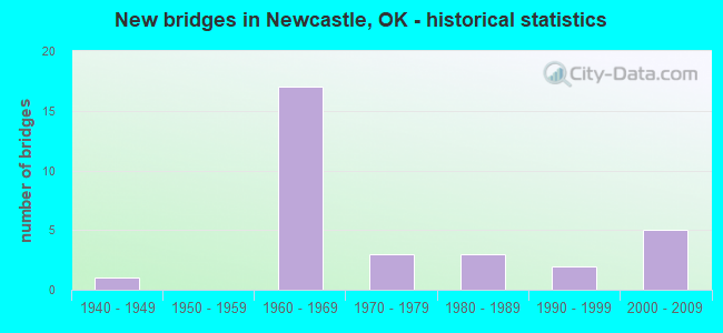
- New bridges - historical statistics
- 11940-1949
- 171960-1969
- 31970-1979
- 31980-1989
- 21990-1999
- 52000-2009


- Bridge Condition - Deck
- 28.6%Good
- 57.1%Satisfactory
- 14.3%Fair

- Bridge Condition - Superstructure
- 14.3%Very good
- 35.7%Good
- 35.7%Satisfactory
- 14.3%Fair

- Bridge Condition - Substructure
- 7.1%Very good
- 35.7%Good
- 35.7%Satisfactory
- 21.4%Fair

- Bridge Condition - Channel
- 8.3%Excellent
- 8.3%Very good
- 16.7%Good
- 41.7%Satisfactory
- 16.7%Fair
- 8.3%Poor

- Bridge Condition - Culverts
- 42.9%Very good
- 57.1%Good
Find on map >> Show street view
Structure Number: 1106, Location: 5.9 MI.N. JCT. SH9 (Lat: 35.268239, Lng: -97.599964), Route carried "on" structure: US 62, Year Built: 1949, Year Reconstructed: 1999, Status: Open, Structure Length: 1.43m (4.69ft), Average Daily Traffic: 16,200 (year 2020), Truck Traffic: 15%, Average Future Daily Traffic: 25,920 (year 2040), Design Load: H 20, Features Intersected: POND CREEK
Minimum Vertical Clearance: 30+ m (98+ ft), Kilometerpoint: 18.824, Lanes on structure: 5, Owner: State Highway Agency, Approaching Roadway Width: 24.4m (80.1ft), Material/Design: Concrete, Design/Construction: Culvert, Number Of Spans In Main Unit: 3, Length of Maximum Span: 5.2m (17.1ft), Curb-To-Curb Width: 24.4m (80.1ft), Out-to-Out Width: 24.4m (80.1ft)
Condition: Channel: Poor, Culverts: Good, Operating Rating: 44.5 metric tons, Method Used To Determine Operating Rating: Allowable Stress (AS), Inventory Rating: 32.7 metric tons, Method Used To Determine Inventory Rating: Allowable Stress (AS), Structural Evaluation: Better than present minimum criteria, Deck Geometry: Superior to present desirable criteria, Waterway Adequacy: Equal to present desirable criteria, Approach Roadway Alignment: Equal to present desirable criteria, Length Of Structure Improvement: 1.43m (4.69ft), Designated Inspection Frequency: Every 24 months, Inspection Date: August 2021, Bridge Improvement Cost: $363,000, Roadway Improvement Cost: $599,000, Total Project Cost: $1,017,000 ( Estimate for 2015)
Find on map >> Show street view
Structure Number: 15775, Location: 3.0 MI S SH37 (Lat: 35.248975, Lng: -97.653419), Route carried "on" structure: Interstate 44, Year Built: 1963, Status: Open, Structure Length: 4.60m (15.09ft), Average Daily Traffic: 17,400 (year 2020), Truck Traffic: 36%, Average Future Daily Traffic: 27,840 (year 2040), Design Load: HS 20, Features Intersected: S.H. 76 UNDER
Minimum Vertical Clearance: 30+ m (98+ ft), Kilometerpoint: 2.746, Lanes on structure: 4, Lanes under structure: 4, Base Highway Network: Yes, Toll: On toll road, Owner: State Toll Authority, Approaching Roadway Width: 24.7m (81.0ft), Skew: 30 degrees, Material/Design: Steel, Design/Construction: Stringer/Multi-beam, Number Of Spans In Main Unit: 3, Length of Maximum Span: 17.1m (56.1ft), Curb-To-Curb Width: 23.8m (78.1ft), Out-to-Out Width: 26.8m (87.9ft)
Condition: Deck: Good, Superstructure: Good, Substructure: Satisfactory, Operating Rating: 44.5 metric tons, Method Used To Determine Operating Rating: Allowable Stress (AS), Inventory Rating: 32.7 metric tons, Method Used To Determine Inventory Rating: Allowable Stress (AS), Structural Evaluation: Equal to present minimum criteria, Deck Geometry: Superior to present desirable criteria, Underclear: Somewhat better than minimum adequacy, Approach Roadway Alignment: Equal to present desirable criteria, Length Of Structure Improvement: 4.60m (15.09ft), Designated Inspection Frequency: Every 24 months, Inspection Date: July 2021, Bridge Improvement Cost: $575,000, Roadway Improvement Cost: $863,000, Total Project Cost: $1,649,000 ( Estimate for 2015), Deck Structure Type: Concrete Cast-file-Place, Wearing Surface/Protective System: Wearing Surface: Monolithic Concrete, Deck Protection: Epoxy Coated Reinforcing
Find on map >> Show street view
Structure Number: 15791, Location: 0.2 MI.S.CLEVELAND CO (Lat: 35.298611, Lng: -97.599722), Route carried "on" structure: County highway , Year Built: 1963, Status: Open, Structure Length: 5.24m (17.19ft), Average Daily Traffic: 1,000 (year 2020), Truck Traffic: 10%, Average Future Daily Traffic: 1,600 (year 2040), Design Load: H 20, Features Intersected: I-44 UNDER, Facility Carried by Structure: CO. RD.
Minimum Vertical Clearance: 30+ m (98+ ft), Kilometerpoint: 1.384, Lanes on structure: 2, Lanes under structure: 4, Owner: State Highway Agency, Approaching Roadway Width: 7.3m (24.0ft), Material/Design: Concrete, Design/Construction: Slab, Number Of Spans In Main Unit: 4, Length of Maximum Span: 16.8m (55.1ft), Curb or Sidewalk Widths: Left: 0.5m (1.6ft), Right: 0.5m (1.6ft), Curb-To-Curb Width: 7.3m (24.0ft), Out-to-Out Width: 8.8m (28.9ft)
Condition: Deck: Satisfactory, Superstructure: Fair, Substructure: Fair, Operating Rating: 43.5 metric tons, Method Used To Determine Operating Rating: Load Factor (LF), Inventory Rating: 26.3 metric tons, Method Used To Determine Inventory Rating: Load Factor (LF), Structural Evaluation: Somewhat better than minimum adequacy, Deck Geometry: Meets minimum limits, Underclear: Somewhat better than minimum adequacy, Approach Roadway Alignment: Equal to present minimum criteria, Length Of Structure Improvement: 8.40m (27.56ft), Designated Inspection Frequency: Every 24 months, Inspection Date: August 2021, Bridge Improvement Cost: $689,000, Roadway Improvement Cost: $1,137,000, Total Project Cost: $1,929,000 ( Estimate for 2015), Deck Structure Type: Concrete Cast-file-Place, Wearing Surface/Protective System: Wearing Surface: Monolithic Concrete
Find on map >> Show street view
Structure Number: 15809, Location: 1.0 MI.S.CLEVELAND CO (Lat: 35.291111, Lng: -97.600000), Route carried "on" structure: State highway 37, Year Built: 1963, Status: Open, Structure Length: 6.31m (20.70ft), Average Daily Traffic: 23,900 (year 2020), Truck Traffic: 15%, Average Future Daily Traffic: 38,240 (year 2040), Design Load: HS 20, Features Intersected: I-44 UNDER
Minimum Vertical Clearance: 30+ m (98+ ft), Kilometerpoint: 6.420, Lanes on structure: 2, Lanes under structure: 4, Owner: State Highway Agency, Approaching Roadway Width: 13.4m (44.0ft), Skew: 22 degrees, Material/Design: Concrete, Design/Construction: Slab, Number Of Spans In Main Unit: 4, Length of Maximum Span: 19.5m (64.0ft), Curb or Sidewalk Widths: Left: 0.5m (1.6ft), Right: 0.5m (1.6ft), Curb-To-Curb Width: 13.4m (44.0ft), Out-to-Out Width: 14.9m (48.9ft)
Condition: Deck: Satisfactory, Superstructure: Satisfactory, Substructure: Satisfactory, Operating Rating: 46.3 metric tons, Method Used To Determine Operating Rating: Load Factor (LF), Inventory Rating: 27.2 metric tons, Method Used To Determine Inventory Rating: Load Factor (LF), Structural Evaluation: Equal to present minimum criteria, Deck Geometry: Equal to present minimum criteria, Underclear: Meets minimum limits, Approach Roadway Alignment: Equal to present minimum criteria, Length Of Structure Improvement: 9.43m (30.94ft), Designated Inspection Frequency: Every 24 months, Inspection Date: August 2021, Bridge Improvement Cost: $1,321,000, Roadway Improvement Cost: $2,180,000, Total Project Cost: $3,699,000 ( Estimate for 2015), Deck Structure Type: Concrete Cast-file-Place, Wearing Surface/Protective System: Wearing Surface: Latex Concrete
Find on map >> Show street view
Structure Number: 15834, Location: 2.0 MI S CLEVELAND CO (Lat: 35.280353, Lng: -97.601897), Route carried "on" structure: US 62, Year Built: 1963, Status: Open, Structure Length: 7.28m (23.88ft), Average Daily Traffic: 16,300 (year 2020), Truck Traffic: 15%, Average Future Daily Traffic: 26,080 (year 2040), Design Load: HS 20, Features Intersected: BAILEY A TP (I-44) UNDER
Minimum Vertical Clearance: 30+ m (98+ ft), Kilometerpoint: 32.110, Lanes on structure: 2, Lanes under structure: 5, Owner: State Highway Agency, Approaching Roadway Width: 11.9m (39.0ft), Skew: 24 degrees, Material/Design: Steel, Design/Construction: Stringer/Multi-beam, Number Of Spans In Main Unit: 4, Length of Maximum Span: 25.0m (82.0ft), Curb or Sidewalk Widths: Left: 0.5m (1.6ft), Right: 0.5m (1.6ft), Curb-To-Curb Width: 11.9m (39.0ft), Out-to-Out Width: 15.5m (50.9ft)
Condition: Deck: Satisfactory, Superstructure: Good, Substructure: Fair, Operating Rating: 44.1 metric tons, Method Used To Determine Operating Rating: Allowable Stress (AS), Inventory Rating: 32.4 metric tons, Method Used To Determine Inventory Rating: Allowable Stress (AS), Structural Evaluation: Somewhat better than minimum adequacy, Deck Geometry: Somewhat better than minimum adequacy, Underclear: Meets minimum limits, Approach Roadway Alignment: High priority of corrective action, Length Of Structure Improvement: 9.91m (32.51ft), Designated Inspection Frequency: Every 24 months, Inspection Date: August 2021, Bridge Improvement Cost: $1,379,000, Roadway Improvement Cost: $2,275,000, Total Project Cost: $3,860,000 ( Estimate for 2015), Deck Structure Type: Concrete Cast-file-Place, Wearing Surface/Protective System: Wearing Surface: Monolithic Concrete
Find on map >> Show street view
Structure Number: 15896, Location: T P BR NO.00.92 (Lat: 35.275011, Lng: -97.606047), Route carried "on" structure: Interstate 44, Year Built: 1964, Status: Open, Structure Length: 0.66m (2.17ft), Average Daily Traffic: 17,400 (year 2020), Truck Traffic: 36%, Average Future Daily Traffic: 27,840 (year 2040), Design Load: HS 20, Features Intersected: CREEK
Minimum Vertical Clearance: 30+ m (98+ ft), Kilometerpoint: 7.176, Lanes on structure: 4, Base Highway Network: Yes, Toll: On toll road, Owner: State Toll Authority, Approaching Roadway Width: 24.7m (81.0ft), Skew: 31 degrees, Material/Design: Concrete, Design/Construction: Culvert, Number Of Spans In Main Unit: 2, Length of Maximum Span: 3.0m (9.8ft), Curb-To-Curb Width: 45.1m (148.0ft), Out-to-Out Width: 45.7m (149.9ft)
Condition: Channel: Fair, Culverts: Very good, Operating Rating: 44.5 metric tons, Method Used To Determine Operating Rating: Load Factor (LF), Inventory Rating: 32.7 metric tons, Method Used To Determine Inventory Rating: Load Factor (LF), Structural Evaluation: Equal to present desirable criteria, Deck Geometry: Superior to present desirable criteria, Waterway Adequacy: Equal to present desirable criteria, Approach Roadway Alignment: Equal to present desirable criteria, Length Of Structure Improvement: 2.86m (9.38ft), Designated Inspection Frequency: Every 24 months, Inspection Date: July 2021, Bridge Improvement Cost: $200,000, Roadway Improvement Cost: $150,000, Total Project Cost: $360,000 ( Estimate for 2015)
Find on map >> Show street view
Structure Number: 16053, Location: T.P.BR.NO.01.72 (Lat: 35.270833, Lng: -97.617778), Route carried "on" structure: County highway N3020, Year Built: 1964, Status: Open, Structure Length: 4.85m (15.91ft), Average Daily Traffic: 5,000 (year 2020), Truck Traffic: 15%, Average Future Daily Traffic: 8,000 (year 2040), Design Load: H 15, Features Intersected: BAILEY A TP (I-44) UNDER
Minimum Vertical Clearance: 30+ m (98+ ft), Kilometerpoint: 5.792, Lanes on structure: 2, Lanes under structure: 4, Owner: State Toll Authority, Approaching Roadway Width: 5.5m (18.0ft), Skew: 1 degrees, Material/Design: Steel, Design/Construction: Stringer/Multi-beam, Number Of Spans In Main Unit: 4, Length of Maximum Span: 13.4m (44.0ft), Curb-To-Curb Width: 5.5m (18.0ft), Out-to-Out Width: 7.0m (23.0ft)
Condition: Deck: Satisfactory, Superstructure: Good, Substructure: Good, Operating Rating: 45.4 metric tons, Method Used To Determine Operating Rating: Load Factor (LF), Inventory Rating: 27.2 metric tons, Method Used To Determine Inventory Rating: Load Factor (LF), Structural Evaluation: Equal to present minimum criteria, Deck Geometry: High priority of replacement, Underclear: High priority of replacement, Approach Roadway Alignment: Somewhat better than minimum adequacy, Length Of Structure Improvement: 4.85m (15.91ft), Designated Inspection Frequency: Every 24 months, Inspection Date: July 2021, Bridge Improvement Cost: $606,000, Roadway Improvement Cost: $909,000, Total Project Cost: $1,736,000 ( Estimate for 2015), Deck Structure Type: Concrete Cast-file-Place, Wearing Surface/Protective System: Wearing Surface: Monolithic Concrete
Find on map >> Show street view
Structure Number: 16088, Location: T.P.BR NO.03.03 (Lat: 35.261944, Lng: -97.638056), Route carried "on" structure: County highway E1200, Year Built: 1964, Status: Open, Structure Length: 5.27m (17.29ft), Average Daily Traffic: 5,000 (year 2020), Truck Traffic: 15%, Average Future Daily Traffic: 8,000 (year 2040), Design Load: H 15, Features Intersected: BAILEY A TP (I-44) UNDER, Facility Carried by Structure: CO. RD. E1210
Minimum Vertical Clearance: 30+ m (98+ ft), Kilometerpoint: 3.701, Lanes on structure: 2, Lanes under structure: 4, Owner: State Toll Authority, Approaching Roadway Width: 5.5m (18.0ft), Skew: 3 degrees, Material/Design: Steel, Design/Construction: Stringer/Multi-beam, Number Of Spans In Main Unit: 4, Length of Maximum Span: 14.9m (48.9ft), Curb-To-Curb Width: 5.5m (18.0ft), Out-to-Out Width: 7.0m (23.0ft)
Condition: Deck: Satisfactory, Superstructure: Satisfactory, Substructure: Satisfactory, Operating Rating: 41.7 metric tons, Method Used To Determine Operating Rating: Load Factor (LF), Inventory Rating: 24.5 metric tons, Method Used To Determine Inventory Rating: Load Factor (LF), Structural Evaluation: Equal to present minimum criteria, Deck Geometry: High priority of replacement, Underclear: High priority of replacement, Approach Roadway Alignment: Somewhat better than minimum adequacy, Length Of Structure Improvement: 5.27m (17.29ft), Designated Inspection Frequency: Every 24 months, Inspection Date: July 2021, Bridge Improvement Cost: $659,000, Roadway Improvement Cost: $989,000, Total Project Cost: $1,887,000 ( Estimate for 2015), Deck Structure Type: Concrete Cast-file-Place, Wearing Surface/Protective System: Wearing Surface: Monolithic Concrete
Find on map >> Show street view
Structure Number: 16091, Location: T.P.BR.NO.0.88 (Lat: 35.276389, Lng: -97.605000), Route carried "on" structure: County highway E1200, Year Built: 1964, Status: Open, Structure Length: 5.33m (17.49ft), Average Daily Traffic: 5,000 (year 2020), Truck Traffic: 15%, Average Future Daily Traffic: 8,000 (year 2040), Design Load: H 15, Features Intersected: BAILEY A TP (I-44) UNDER
Minimum Vertical Clearance: 30+ m (98+ ft), Kilometerpoint: 7.240, Lanes on structure: 2, Lanes under structure: 4, Owner: State Toll Authority, Approaching Roadway Width: 5.5m (18.0ft), Skew: 3 degrees, Material/Design: Steel, Design/Construction: Stringer/Multi-beam, Number Of Spans In Main Unit: 4, Length of Maximum Span: 14.9m (48.9ft), Curb-To-Curb Width: 5.5m (18.0ft), Out-to-Out Width: 7.0m (23.0ft)
Condition: Deck: Satisfactory, Superstructure: Satisfactory, Substructure: Good, Operating Rating: 41.7 metric tons, Method Used To Determine Operating Rating: Load Factor (LF), Inventory Rating: 25.4 metric tons, Method Used To Determine Inventory Rating: Load Factor (LF), Structural Evaluation: Equal to present minimum criteria, Deck Geometry: High priority of replacement, Underclear: High priority of replacement, Approach Roadway Alignment: Somewhat better than minimum adequacy, Length Of Structure Improvement: 5.33m (17.49ft), Designated Inspection Frequency: Every 24 months, Inspection Date: July 2021, Bridge Improvement Cost: $666,000, Roadway Improvement Cost: $999,000, Total Project Cost: $1,906,000 ( Estimate for 2015), Deck Structure Type: Concrete Cast-file-Place, Wearing Surface/Protective System: Wearing Surface: Monolithic Concrete
Find on map >> Show street view
Structure Number: 161, Location: T P BR NO 5.41 (Lat: 35.241389, Lng: -97.670833), Route carried "on" structure: County highway N2990, Year Built: 1964, Status: Open, Structure Length: 5.46m (17.91ft), Average Daily Traffic: 5,000 (year 2020), Truck Traffic: 15%, Average Future Daily Traffic: 8,000 (year 2040), Design Load: H 15, Features Intersected: BAILEY A TP (I-44) UNDER
Minimum Vertical Clearance: 30+ m (98+ ft), Kilometerpoint: 55.704, Lanes on structure: 2, Lanes under structure: 4, Owner: State Toll Authority, Approaching Roadway Width: 5.5m (18.0ft), Skew: 3 degrees, Material/Design: Steel, Design/Construction: Stringer/Multi-beam, Number Of Spans In Main Unit: 4, Length of Maximum Span: 14.9m (48.9ft), Curb-To-Curb Width: 5.5m (18.0ft), Out-to-Out Width: 7.0m (23.0ft)
Condition: Deck: Satisfactory, Superstructure: Satisfactory, Substructure: Good, Operating Rating: 41.7 metric tons, Method Used To Determine Operating Rating: Load Factor (LF), Inventory Rating: 25.4 metric tons, Method Used To Determine Inventory Rating: Load Factor (LF), Structural Evaluation: Equal to present minimum criteria, Deck Geometry: High priority of replacement, Underclear: High priority of replacement, Approach Roadway Alignment: Somewhat better than minimum adequacy, Length Of Structure Improvement: 5.46m (17.91ft), Designated Inspection Frequency: Every 24 months, Inspection Date: July 2021, Bridge Improvement Cost: $682,000, Roadway Improvement Cost: $1,023,000, Total Project Cost: $1,952,000 ( Estimate for 2015), Deck Structure Type: Concrete Cast-file-Place, Wearing Surface/Protective System: Wearing Surface: Monolithic Concrete
Find on map >> Show street view
Structure Number: 19134, Location: 4.0 MI. E. JCT. US62 (Lat: 35.181672, Lng: -97.532206), Route carried "on" structure: State highway 9, Year Built: 1976, Status: Open, Structure Length: 0.70m (2.30ft), Average Daily Traffic: 16,000 (year 2020), Truck Traffic: 16%, Average Future Daily Traffic: 25,600 (year 2040), Design Load: HS 20, Features Intersected: CREEK
Minimum Vertical Clearance: 30+ m (98+ ft), Kilometerpoint: 6.275, Lanes on structure: 4, Base Highway Network: Yes, Owner: State Highway Agency, Approaching Roadway Width: 11.6m (38.1ft), Skew: 10 degrees, Material/Design: Concrete, Design/Construction: Culvert, Number Of Spans In Main Unit: 2, Length of Maximum Span: 3.0m (9.8ft)
Condition: Channel: Satisfactory, Culverts: Good, Operating Rating: 44.7 metric tons, Method Used To Determine Operating Rating: Allowable Stress (AS), Inventory Rating: 26.8 metric tons, Method Used To Determine Inventory Rating: Allowable Stress (AS), Structural Evaluation: Equal to present minimum criteria, Waterway Adequacy: Equal to present minimum criteria, Approach Roadway Alignment: Equal to present desirable criteria, Length Of Structure Improvement: 0.70m (2.30ft), Designated Inspection Frequency: Every 24 months, Inspection Date: August 2021, Bridge Improvement Cost: $230,000, Roadway Improvement Cost: $380,000, Total Project Cost: $644,000 ( Estimate for 2015)
Find on map >> Show street view
Structure Number: 19136, Location: 5.6 MI. E. JCT. US62 (Lat: 35.182500, Lng: -97.503386), Route carried "on" structure: State highway 9, Year Built: 1976, Status: Open, Structure Length: 0.67m (2.20ft), Average Daily Traffic: 18,700 (year 2020), Truck Traffic: 16%, Average Future Daily Traffic: 29,920 (year 2040), Design Load: HS 20, Features Intersected: CREEK
Minimum Vertical Clearance: 30+ m (98+ ft), Kilometerpoint: 8.882, Lanes on structure: 5, Base Highway Network: Yes, Owner: State Highway Agency, Approaching Roadway Width: 23.8m (78.1ft), Material/Design: Concrete, Design/Construction: Culvert, Number Of Spans In Main Unit: 3, Length of Maximum Span: 1.8m (5.9ft)
Condition: Channel: Very good, Culverts: Very good, Inventory Rating: 79.1 metric tons, Method Used To Determine Inventory Rating: Load Factor (LF), Structural Evaluation: Equal to present desirable criteria, Waterway Adequacy: Equal to present minimum criteria, Approach Roadway Alignment: Equal to present desirable criteria, Length Of Structure Improvement: 0.67m (2.20ft), Designated Inspection Frequency: Every 24 months, Inspection Date: August 2021, Bridge Improvement Cost: $230,000, Roadway Improvement Cost: $380,000, Total Project Cost: $644,000 ( Estimate for 2015)
Find on map >> Show street view
Structure Number: 19179, Location: 3.4 MI E JCT US 277 (Lat: 35.182144, Lng: -97.538281), Route carried "on" structure: State highway 9, Year Built: 1976, Status: Open, Structure Length: 1.34m (4.40ft), Average Daily Traffic: 16,000 (year 2020), Truck Traffic: 16%, Average Future Daily Traffic: 25,600 (year 2040), Design Load: HS 20, Features Intersected: CREEK
Minimum Vertical Clearance: 30+ m (98+ ft), Kilometerpoint: 5.583, Lanes on structure: 4, Base Highway Network: Yes, Owner: State Highway Agency, Approaching Roadway Width: 11.6m (38.1ft), Skew: 13 degrees, Material/Design: Concrete, Design/Construction: Culvert, Number Of Spans In Main Unit: 2, Length of Maximum Span: 3.0m (9.8ft)
Condition: Channel: Good, Culverts: Good, Operating Rating: 44.5 metric tons, Method Used To Determine Operating Rating: Allowable Stress (AS), Inventory Rating: 32.7 metric tons, Method Used To Determine Inventory Rating: Allowable Stress (AS), Structural Evaluation: Better than present minimum criteria, Waterway Adequacy: Equal to present minimum criteria, Approach Roadway Alignment: Equal to present desirable criteria, Length Of Structure Improvement: 1.34m (4.40ft), Designated Inspection Frequency: Every 24 months, Inspection Date: August 2021, Bridge Improvement Cost: $230,000, Roadway Improvement Cost: $380,000, Total Project Cost: $644,000 ( Estimate for 2015)
Find on map >> Show street view
Structure Number: 21267, Location: 1.0 N; 1.4 W NEWCASTLE (Lat: 35.261894, Lng: -97.624214), Route carried "on" structure: City street E1210, Year Built: 1986, Status: Open, Structure Length: 1.52m (4.99ft), Average Daily Traffic: 100 (year 2020), Truck Traffic: 5%, Average Future Daily Traffic: 160 (year 2040), Design Load: HS 20, Features Intersected: POND CREEK, Facility Carried by Structure: NW 16TH ST
Minimum Vertical Clearance: 30+ m (98+ ft), Kilometerpoint: 0.966, Lanes on structure: 2, Owner: City or Municipal Highway Agency, Approaching Roadway Width: 6.7m (22.0ft), Material/Design: Prestressed concrete, Design/Construction: Stringer/Multi-beam, Number Of Spans In Main Unit: 1, Length of Maximum Span: 15.2m (49.9ft), Curb or Sidewalk Widths: Left: 0.1m (0.3ft), Right: 0.1m (0.3ft), Curb-To-Curb Width: 8.5m (27.9ft), Out-to-Out Width: 8.7m (28.5ft)
Condition: Deck: Fair, Superstructure: Satisfactory, Substructure: Satisfactory, Channel: Satisfactory, Operating Rating: 58.9 metric tons, Method Used To Determine Operating Rating: Load Factor (LF), Inventory Rating: 26.7 metric tons, Method Used To Determine Inventory Rating: Load Factor (LF), Structural Evaluation: Equal to present minimum criteria, Deck Geometry: Better than present minimum criteria, Waterway Adequacy: Better than present minimum criteria, Approach Roadway Alignment: Equal to present desirable criteria, Length Of Structure Improvement: 4.31m (14.14ft), Designated Inspection Frequency: Every 24 months, Inspection Date: October 2021, Bridge Improvement Cost: $220,000, Roadway Improvement Cost: $121,000, Total Project Cost: $350,000 ( Estimate for 2015), Deck Structure Type: Concrete Cast-file-Place, Wearing Surface/Protective System: Wearing Surface: Monolithic Concrete
Find on map >> Show street view
Structure Number: 21495, Location: 2.7 S; 3.0 E NEWCASTLE (Lat: 35.208231, Lng: -97.546978), Route carried "on" structure: City street N3060, Year Built: 1987, Status: Open, Structure Length: 1.22m (4.00ft), Average Daily Traffic: 100 (year 2020), Truck Traffic: 10%, Average Future Daily Traffic: 160 (year 2040), Design Load: HS 20, Features Intersected: CREEK, Facility Carried by Structure: S PENNSYLVANIA AVE
Minimum Vertical Clearance: 30+ m (98+ ft), Kilometerpoint: 1.127, Lanes on structure: 2, Owner: City or Municipal Highway Agency, Approaching Roadway Width: 6.1m (20.0ft), Material/Design: Steel, Design/Construction: Stringer/Multi-beam, Number Of Spans In Main Unit: 1, Length of Maximum Span: 11.6m (38.1ft), Curb or Sidewalk Widths: Left: 0.2m (0.7ft), Right: 0.2m (0.7ft), Curb-To-Curb Width: 5.6m (18.4ft), Out-to-Out Width: 6.1m (20.0ft)
Condition: Deck: Satisfactory, Superstructure: Fair, Substructure: Satisfactory, Channel: Satisfactory, Operating Rating: 53.3 metric tons, Method Used To Determine Operating Rating: Load Factor (LF), Inventory Rating: 32.0 metric tons, Method Used To Determine Inventory Rating: Load Factor (LF), Structural Evaluation: Somewhat better than minimum adequacy, Deck Geometry: Meets minimum limits, Waterway Adequacy: Somewhat better than minimum adequacy, Approach Roadway Alignment: Equal to present desirable criteria, Length Of Structure Improvement: 3.83m (12.57ft), Designated Inspection Frequency: Every 24 months, Inspection Date: October 2021, Bridge Improvement Cost: $196,000, Roadway Improvement Cost: $108,000, Total Project Cost: $311,000 ( Estimate for 2015), Deck Structure Type: Concrete Cast-file-Place, Wearing Surface/Protective System: Wearing Surface: Monolithic Concrete
Find on map >> Show street view
Structure Number: 22008, Location: .3 MI S CLEV. C/L (Lat: 35.183919, Lng: -97.493042), Route carried "on" structure: Interstate 35, Year Built: 1988, Status: Open, Structure Length: 3.66m (12.01ft), Average Daily Traffic: 28,100 (year 2020), Truck Traffic: 36%, Average Future Daily Traffic: 44,960 (year 2040), Design Load: HS 20, Features Intersected: S. CANADIAN O'FLOW
Minimum Vertical Clearance: 30+ m (98+ ft), Kilometerpoint: 40.803, Lanes on structure: 2, Base Highway Network: Yes, Owner: State Highway Agency, Approaching Roadway Width: 15.8m (51.8ft), Skew: 10 degrees, Material/Design: Prestressed concrete, Design/Construction: Stringer/Multi-beam, Number Of Spans In Main Unit: 3, Length of Maximum Span: 12.2m (40.0ft), Curb-To-Curb Width: 15.8m (51.8ft), Out-to-Out Width: 16.8m (55.1ft)
Condition: Deck: Good, Superstructure: Very good, Substructure: Good, Channel: Good, Operating Rating: 60.8 metric tons, Method Used To Determine Operating Rating: Load Factor (LF), Inventory Rating: 36.3 metric tons, Method Used To Determine Inventory Rating: Load Factor (LF), Structural Evaluation: Better than present minimum criteria, Deck Geometry: Superior to present desirable criteria, Waterway Adequacy: Equal to present desirable criteria, Approach Roadway Alignment: Equal to present desirable criteria, Length Of Structure Improvement: 6.86m (22.51ft), Designated Inspection Frequency: Every 24 months, Inspection Date: August 2021, Bridge Improvement Cost: $579,000, Roadway Improvement Cost: $955,000, Total Project Cost: $1,621,000 ( Estimate for 2015), Deck Structure Type: Concrete Cast-file-Place, Wearing Surface/Protective System: Wearing Surface: Monolithic Concrete, Deck Protection: Epoxy Coated Reinforcing
Find on map >> Show street view
Structure Number: 22749, Location: 1.3 MI. W. JCT. US62 (Lat: 35.290822, Lng: -97.622756), Route carried "on" structure: State highway 37, Year Built: 1991, Status: Open, Structure Length: 1.04m (3.41ft), Average Daily Traffic: 16,800 (year 2020), Truck Traffic: 15%, Average Future Daily Traffic: 26,880 (year 2040), Design Load: HS 20, Features Intersected: CREEK
Minimum Vertical Clearance: 30+ m (98+ ft), Kilometerpoint: 4.344, Lanes on structure: 5, Owner: State Highway Agency, Approaching Roadway Width: 19.8m (65.0ft), Skew: 1 degrees, Material/Design: Concrete, Design/Construction: Culvert, Number Of Spans In Main Unit: 3, Length of Maximum Span: 3.0m (9.8ft), Curb-To-Curb Width: 19.5m (64.0ft), Out-to-Out Width: 19.5m (64.0ft)
Condition: Channel: Satisfactory, Culverts: Good, Operating Rating: 54.4 metric tons, Method Used To Determine Operating Rating: Load Factor (LF), Inventory Rating: 32.7 metric tons, Method Used To Determine Inventory Rating: Load Factor (LF), Structural Evaluation: Better than present minimum criteria, Deck Geometry: Meets minimum limits, Waterway Adequacy: Equal to present desirable criteria, Approach Roadway Alignment: Equal to present desirable criteria, Length Of Structure Improvement: 1.04m (3.41ft), Designated Inspection Frequency: Every 24 months, Inspection Date: August 2021, Bridge Improvement Cost: $306,000, Roadway Improvement Cost: $504,000, Total Project Cost: $856,000 ( Estimate for 2015)
Find on map >> Show street view
Structure Number: 25613, Location: 1.66 MI S OF JCT 130/US62 (Lat: 35.223186, Lng: -97.600125), Route carried "on" structure: US 62, Year Built: 1999, Status: Open, Structure Length: 1.41m (4.63ft), Average Daily Traffic: 3,300 (year 2020), Truck Traffic: 16%, Average Future Daily Traffic: 5,280 (year 2040), Design Load: HS 20, Features Intersected: POND CREEK TRIB.
Minimum Vertical Clearance: 30+ m (98+ ft), Kilometerpoint: 13.863, Lanes on structure: 4, Base Highway Network: Yes, Owner: State Highway Agency, Approaching Roadway Width: 11.6m (38.1ft), Skew: 3 degrees, Material/Design: Concrete, Design/Construction: Culvert, Number Of Spans In Main Unit: 3, Length of Maximum Span: 3.7m (12.1ft), Curb-To-Curb Width: 11.6m (38.1ft), Out-to-Out Width: 44.5m (146.0ft)
Condition: Channel: Fair, Culverts: Very good, Operating Rating: 54.4 metric tons, Method Used To Determine Operating Rating: Load Factor (LF), Inventory Rating: 32.7 metric tons, Method Used To Determine Inventory Rating: Load Factor (LF), Structural Evaluation: Equal to present desirable criteria, Deck Geometry: High priority of replacement, Waterway Adequacy: Equal to present desirable criteria, Approach Roadway Alignment: Equal to present desirable criteria, Length Of Structure Improvement: 1.41m (4.63ft), Designated Inspection Frequency: Every 24 months, Inspection Date: August 2021, Bridge Improvement Cost: $230,000, Roadway Improvement Cost: $380,000, Total Project Cost: $644,000 ( Estimate for 2015)
Find on map >> Show street view
Structure Number: 25961, Location: 7.8 MI. N-E SH 74B (Lat: 35.183478, Lng: -97.599928), Route carried "on" structure: US 62, Year Built: 2000, Status: Open, Structure Length: 7.92m (25.98ft), Average Daily Traffic: 6,000 (year 2020), Truck Traffic: 15%, Average Future Daily Traffic: 9,600 (year 2040), Design Load: HS 20, Features Intersected: BAILEY SPUR/ S.H. 9 UND
Minimum Vertical Clearance: 30+ m (98+ ft), Kilometerpoint: 9.654, Lanes on structure: 3, Lanes under structure: 4, Owner: State Highway Agency, Approaching Roadway Width: 15.2m (49.9ft), Skew: 10 degrees, Material/Design: Prestressed concrete, Design/Construction: Stringer/Multi-beam, Number Of Spans In Main Unit: 2, Length of Maximum Span: 39.6m (129.9ft), Curb-To-Curb Width: 15.0m (49.2ft), Out-to-Out Width: 16.2m (53.1ft)
Condition: Deck: Good, Superstructure: Good, Substructure: Good, Operating Rating: 85.3 metric tons, Method Used To Determine Operating Rating: Load Factor (LF), Inventory Rating: 50.8 metric tons, Method Used To Determine Inventory Rating: Load Factor (LF), Structural Evaluation: Better than present minimum criteria, Deck Geometry: Equal to present minimum criteria, Underclear: Equal to present desirable criteria, Approach Roadway Alignment: Superior to present desirable criteria, Length Of Structure Improvement: 8.45m (27.72ft), Designated Inspection Frequency: Every 24 months, Inspection Date: July 2021, Bridge Improvement Cost: $924,000, Roadway Improvement Cost: $1,525,000, Total Project Cost: $2,588,000 ( Estimate for 2015), Deck Structure Type: Concrete Cast-file-Place, Wearing Surface/Protective System: Wearing Surface: Monolithic Concrete, Deck Protection: Epoxy Coated Reinforcing
Find on map >> Show street view
Structure Number: 2606, Location: MC CLAIN&CLEVELAND CL (Lat: 35.302072, Lng: -97.598917), Route carried "on" structure: Interstate 44, Year Built: 2000, Status: Open, Structure Length: 52.36m (171.78ft), Average Daily Traffic: 45,900 (year 2020), Truck Traffic: 36%, Average Future Daily Traffic: 73,440 (year 2040), Design Load: HS 20, Features Intersected: S. CANADIAN RIVER
Minimum Vertical Clearance: 30+ m (98+ ft), Kilometerpoint: 1.786, Lanes on structure: 4, Base Highway Network: Yes, Owner: State Highway Agency, Approaching Roadway Width: 34.1m (111.9ft), Skew: 30 degrees, Material/Design: Prestressed concrete, Design/Construction: Stringer/Multi-beam, Number Of Spans In Main Unit: 17, Length of Maximum Span: 30.8m (101.0ft), Curb-To-Curb Width: 34.1m (111.9ft), Out-to-Out Width: 34.7m (113.8ft)
Condition: Deck: Fair, Superstructure: Good, Substructure: Fair, Channel: Satisfactory, Operating Rating: 83.5 metric tons, Method Used To Determine Operating Rating: Load Factor (LF), Inventory Rating: 43.5 metric tons, Method Used To Determine Inventory Rating: Load Factor (LF), Structural Evaluation: Somewhat better than minimum adequacy, Deck Geometry: Superior to present desirable criteria, Waterway Adequacy: Superior to present desirable criteria, Approach Roadway Alignment: Superior to present desirable criteria, Length Of Structure Improvement: 57.62m (189.04ft), Designated Inspection Frequency: Every 24 months, Inspection Date: March 2020, Bridge Improvement Cost: $5,245,000, Roadway Improvement Cost: $4,500,000, Total Project Cost: $10,297,000 ( Estimate for 2015), Deck Structure Type: Concrete Cast-file-Place, Wearing Surface/Protective System: Wearing Surface: Monolithic Concrete, Deck Protection: Epoxy Coated Reinforcing
Find on map >> Show street view
Structure Number: 27477, Location: S. OF NORMAN (Lat: 35.184039, Lng: -97.493197), Route carried "on" structure: Ramp State highway 35, Year Built: 2006, Status: Open, Structure Length: 3.66m (12.01ft), Average Daily Traffic: 6,650 (year 2020), Truck Traffic: 12%, Average Future Daily Traffic: 10,640 (year 2040), Design Load: HL 93, Features Intersected: S. CANADIAN O'FLOW
Minimum Vertical Clearance: 30+ m (98+ ft), Kilometerpoint: 65.668, Lanes on structure: 2, Owner: State Highway Agency, Approaching Roadway Width: 8.8m (28.9ft), Material/Design: Prestressed concrete, Design/Construction: Stringer/Multi-beam, Number Of Spans In Main Unit: 3, Length of Maximum Span: 12.2m (40.0ft), Curb-To-Curb Width: 8.8m (28.9ft), Out-to-Out Width: 10.4m (34.1ft)
Condition: Deck: Good, Superstructure: Very good, Substructure: Very good, Channel: Excellent, Operating Rating: 70.8 metric tons, Method Used To Determine Operating Rating: Load Factor (LF), Inventory Rating: 41.7 metric tons, Method Used To Determine Inventory Rating: Load Factor (LF), Structural Evaluation: Equal to present desirable criteria, Deck Geometry: Meets minimum limits, Waterway Adequacy: Equal to present desirable criteria, Approach Roadway Alignment: Equal to present desirable criteria, Length Of Structure Improvement: 4.39m (14.40ft), Designated Inspection Frequency: Every 24 months, Inspection Date: August 2021, Bridge Improvement Cost: $584,000, Roadway Improvement Cost: $963,000, Total Project Cost: $1,635,000 ( Estimate for 2015), Deck Structure Type: Concrete Cast-file-Place, Wearing Surface/Protective System: Wearing Surface: Monolithic Concrete, Deck Protection: Epoxy Coated Reinforcing
Find on map >> Show street view
Structure Number: 15775, Location: 3.0 MI S SH37 (Lat: 35.248975, Lng: -97.653419), Route carried "under" structure: State highway 76, Year Built: 1963, Structure Length: 0. m, Average Daily Traffic: 6,500 (year 2020), Truck Traffic: 15%, Features Intersected: S.H. 76 UNDER, Facility Carried by Structure: BAILEY A TP (I-44)
Minimum Vertical Clearance: 5.16m (16.93ft), Kilometerpoint: 12.678, Lanes on structure: 4, Lanes under structure: 2, Material/Design: Steel, Design/Construction: Stringer/Multi-beam, Length of Maximum Span: 17.1m (56.1ft)
Find on map >> Show street view
Structure Number: 15791, Location: 0.2 MI.S.CLEVELAND CO (Lat: 35.298611, Lng: -97.599722), Route carried "under" structure: Interstate 44, Year Built: 1963, Structure Length: 0. m, Average Daily Traffic: 45,900 (year 2020), Truck Traffic: 36%, Features Intersected: I-44 UNDER, Facility Carried by Structure: CO. RD.
Minimum Vertical Clearance: 4.95m (16.24ft), Kilometerpoint: 1.384, Lanes on structure: 2, Lanes under structure: 4, Material/Design: Concrete, Design/Construction: Slab, Length of Maximum Span: 16.8m (55.1ft)
Find on map >> Show street view
Structure Number: 15809, Location: 1.0 MI.S.CLEVELAND CO (Lat: 35.291111, Lng: -97.600000), Route carried "under" structure: Interstate 44, Year Built: 1963, Structure Length: 0. m, Average Daily Traffic: 34,000 (year 2020), Truck Traffic: 36%, Features Intersected: I-44 UNDER, Facility Carried by Structure: S.H. 37
Minimum Vertical Clearance: 5.08m (16.67ft), Kilometerpoint: 0.595, Lanes on structure: 2, Lanes under structure: 4, Material/Design: Concrete, Design/Construction: Slab, Length of Maximum Span: 19.5m (64.0ft)
Find on map >> Show street view
Structure Number: 15834, Location: 2.0 MI S CLEVELAND CO (Lat: 35.280353, Lng: -97.601897), Route carried "under" structure: Interstate 44, Year Built: 1963, Structure Length: 0. m, Average Daily Traffic: 17,400 (year 2020), Truck Traffic: 36%, Features Intersected: BAILEY A TP (I-44) UNDER, Facility Carried by Structure: U.S. 62
Minimum Vertical Clearance: 5.49m (18.01ft), Kilometerpoint: 8.270, Lanes on structure: 2, Lanes under structure: 4, Toll: On toll road, Material/Design: Steel, Design/Construction: Stringer/Multi-beam, Length of Maximum Span: 25.0m (82.0ft)
Find on map >> Show street view
Structure Number: 16053, Location: T.P.BR.NO.01.72 (Lat: 35.270833, Lng: -97.617778), Route carried "under" structure: Interstate 44, Year Built: 1964, Structure Length: 0. m, Average Daily Traffic: 17,400 (year 2020), Truck Traffic: 36%, Features Intersected: BAILEY A TP (I-44) UNDER, Facility Carried by Structure: CO. RD. N3020
Minimum Vertical Clearance: 5.00m (16.40ft), Kilometerpoint: 5.792, Lanes on structure: 2, Lanes under structure: 4, Toll: On toll road, Material/Design: Steel, Design/Construction: Stringer/Multi-beam, Length of Maximum Span: 13.4m (44.0ft)
Find on map >> Show street view
Structure Number: 16088, Location: T.P.BR NO.03.03 (Lat: 35.261944, Lng: -97.638056), Route carried "under" structure: Interstate 44, Year Built: 1964, Structure Length: 0. m, Average Daily Traffic: 17,400 (year 2020), Truck Traffic: 36%, Features Intersected: BAILEY A TP (I-44) UNDER, Facility Carried by Structure: CO. RD. E1210
Minimum Vertical Clearance: 4.95m (16.24ft), Kilometerpoint: 3.701, Lanes on structure: 2, Lanes under structure: 4, Toll: On toll road, Material/Design: Steel, Design/Construction: Stringer/Multi-beam, Length of Maximum Span: 14.9m (48.9ft)
Find on map >> Show street view
Structure Number: 16091, Location: T.P.BR.NO.0.88 (Lat: 35.276389, Lng: -97.605000), Route carried "under" structure: Interstate 44, Year Built: 1964, Structure Length: 0. m, Average Daily Traffic: 17,400 (year 2020), Truck Traffic: 36%, Features Intersected: BAILEY A TP (I-44) UNDER, Facility Carried by Structure: CO. RD. E1200
Minimum Vertical Clearance: 4.98m (16.34ft), Kilometerpoint: 7.240, Lanes on structure: 2, Lanes under structure: 4, Toll: On toll road, Material/Design: Steel, Design/Construction: Stringer/Multi-beam, Length of Maximum Span: 14.9m (48.9ft)
Find on map >> Show street view
Structure Number: 161, Location: T P BR NO 5.41 (Lat: 35.241389, Lng: -97.670833), Route carried "under" structure: Interstate 44, Year Built: 1964, Structure Length: 0. m, Average Daily Traffic: 17,600 (year 2020), Truck Traffic: 36%, Features Intersected: BAILEY A TP (I-44) UNDER, Facility Carried by Structure: CO. RD. N2990
Minimum Vertical Clearance: 5.05m (16.57ft), Kilometerpoint: 55.704, Lanes on structure: 2, Lanes under structure: 4, Toll: On toll road, Material/Design: Steel, Design/Construction: Stringer/Multi-beam, Length of Maximum Span: 14.9m (48.9ft)
Find on map >> Show street view
Structure Number: 2596, Location: 7.8 MI N-E SH 74B (Lat: 35.183461, Lng: -97.599656), Route carried "under" structure: Other road , Year Built: 2000, Structure Length: 0. m, Average Daily Traffic: 2,700 (year 2020), Truck Traffic: 15%, Features Intersected: BAILEY SPUR/ S.H. 9 UND, Facility Carried by Structure: U.S. 62
Minimum Vertical Clearance: 5.61m (18.41ft), Kilometerpoint: 8.142, Lanes on structure: 3, Lanes under structure: 4, Toll: On toll road, Material/Design: Prestressed concrete, Design/Construction: Stringer/Multi-beam, Length of Maximum Span: 39.6m (129.9ft)
Find on map >> Show street view
Structure Number: 25961, Location: 7.8 MI. N-E SH 74B (Lat: 35.183478, Lng: -97.599928), Route carried "under" structure: Other road , Year Built: 2000, Structure Length: 0. m, Average Daily Traffic: 2,700 (year 2020), Truck Traffic: 15%, Features Intersected: BAILEY SPUR/ S.H. 9 UND, Facility Carried by Structure: U.S. 62
Minimum Vertical Clearance: 5.55m (18.21ft), Kilometerpoint: 8.142, Lanes on structure: 3, Lanes under structure: 4, Toll: On toll road, Material/Design: Prestressed concrete, Design/Construction: Stringer/Multi-beam, Length of Maximum Span: 39.6m (129.9ft)