Bridge Statistics for Milford Mill, Maryland (MD)
Condition, Traffic, Stress, Structural Evaluation, Project Costs
- National Bridge Inventory (NBI) Statistics
- 14Number of bridges
- 82ft / 25.2mTotal length
- $1,044,000Total costs
- 495,520Total average daily traffic
- 6,516Total average daily truck traffic
- National Bridge Inventory (NBI) Registered Bridges for Milford Mill
- No street view available for this location
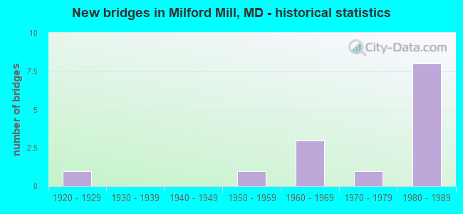
- New bridges - historical statistics
- 11920-1929
- 11950-1959
- 31960-1969
- 11970-1979
- 81980-1989


- Bridge Condition - Deck
- 40.0%Good
- 20.0%Satisfactory
- 20.0%Fair
- 20.0%Poor

- Bridge Condition - Superstructure
- 20.0%Good
- 20.0%Satisfactory
- 40.0%Fair
- 20.0%Poor

- Bridge Condition - Substructure
- 20.0%Good
- 60.0%Satisfactory
- 20.0%Fair

- Bridge Condition - Channel
- 20.0%Excellent
- 40.0%Good
- 10.0%Satisfactory
- 30.0%Fair

- Bridge Condition - Culverts
- 28.6%Good
- 57.1%Satisfactory
- 14.3%Fair
Find on map >> Show street view
Structure Number: 10000003030901, Location: @ METRO (Lat: 0.000108, Lng: -0.000019), Route carried "on" structure: Ramp Interstate 795, Year Built: 1983, Status: Open, Structure Length: 7.19m (23.59ft), Average Daily Traffic: 37,780 (year 2016), Truck Traffic: 8%, Average Future Daily Traffic: 40,800 (year 2036), Design Load: HS 20, Features Intersected: MTA METRO
Minimum Vertical Clearance: 30+ m (98+ ft), Kilometerpoint: 0.000, Lanes on structure: 2, Base Highway Network: Yes, Owner: State Highway Agency, Approaching Roadway Width: 14.3m (46.9ft), Material/Design: Steel continuous, Design/Construction: Stringer/Multi-beam, Number Of Spans In Main Unit: 3, Length of Maximum Span: 23.5m (77.1ft), Curb-To-Curb Width: 14.3m (46.9ft), Out-to-Out Width: 15.5m (50.9ft)
Condition: Deck: Good, Superstructure: Satisfactory, Substructure: Satisfactory, Operating Rating: 74.4 metric tons, Method Used To Determine Operating Rating: Load Factor (LF), Inventory Rating: 44.0 metric tons, Method Used To Determine Inventory Rating: Load Factor (LF), Structural Evaluation: Equal to present minimum criteria, Deck Geometry: Superior to present desirable criteria, Underclear: Superior to present desirable criteria, Approach Roadway Alignment: Equal to present desirable criteria, Length Of Structure Improvement: 7.19m (23.59ft), Designated Inspection Frequency: Every 24 months, Inspection Date: May 2021, Deck Structure Type: Concrete Cast-file-Place, Wearing Surface/Protective System: Wearing Surface: Monolithic Concrete, Deck Protection: Epoxy Coated Reinforcing
Find on map >> Show street view
Structure Number: 200000B-007601, Location: 250 FT E SCOTTS HILL DR (Lat: 39.359914, Lng: -76.744753), Route carried "on" structure: County highway 1800, Year Built: 1983, Status: Open, Structure Length: 2.93m (9.61ft), Average Daily Traffic: 24,976 (year 2021), Truck Traffic: 5%, Average Future Daily Traffic: 37,186 (year 2041), Design Load: HS 20, Features Intersected: GWYNNS FALLS, Facility Carried by Structure: MILFORD MILL RD
Minimum Vertical Clearance: 30+ m (98+ ft), Kilometerpoint: 1.255, Lanes on structure: 4, Owner: County Highway Agency, Approaching Roadway Width: 13.4m (44.0ft), Skew: 2 degrees, Material/Design: Prestressed concrete, Design/Construction: Box Beam or Girders - Multiple, Number Of Spans In Main Unit: 1, Length of Maximum Span: 28.0m (91.9ft), Curb or Sidewalk Widths: Left: 1.9m (6.2ft), Right: 1.9m (6.2ft), Curb-To-Curb Width: 13.4m (44.0ft), Out-to-Out Width: 18.0m (59.1ft)
Condition: Deck: Fair, Superstructure: Fair, Substructure: Satisfactory, Channel: Fair, Inventory Rating: 65.3 metric tons, Method Used To Determine Inventory Rating: Load Factor (LF), Structural Evaluation: Somewhat better than minimum adequacy, Deck Geometry: High priority of replacement, Waterway Adequacy: Somewhat better than minimum adequacy, Approach Roadway Alignment: Equal to present desirable criteria, Designated Inspection Frequency: Every 24 months, Inspection Date: June 2021, Wearing Surface/Protective System: Wearing Surface: Monolithic Concrete
Find on map >> Show street view
Structure Number: 200000B-017501, Location: 0.2 MI S OF KRATZ LA (Lat: 39.333967, Lng: -76.788314), Route carried "on" structure: County highway 2095, Year Built: 1920, Status: Posted for load, Structure Length: 0.94m (3.08ft), Average Daily Traffic: 2,265 (year 2020), Truck Traffic: 5%, Average Future Daily Traffic: 3,740 (year 2040), Features Intersected: BENS RUN, Facility Carried by Structure: RIDGE ROAD
Minimum Vertical Clearance: 30+ m (98+ ft), Kilometerpoint: 2.703, Lanes on structure: 2, Owner: County Highway Agency, Approaching Roadway Width: 4.9m (16.1ft), Material/Design: Concrete, Design/Construction: Tee Beam, Number Of Spans In Main Unit: 1, Length of Maximum Span: 8.8m (28.9ft), Curb-To-Curb Width: 6.0m (19.7ft), Out-to-Out Width: 6.7m (22.0ft)
Condition: Deck: Satisfactory, Superstructure: Fair, Substructure: Fair, Channel: Fair, Operating Rating: 32.7 metric tons, Method Used To Determine Operating Rating: Field evaluation and documented engineering judgment, Inventory Rating: 32.7 metric tons, Method Used To Determine Inventory Rating: Field evaluation and documented engineering judgment, Structural Evaluation: Somewhat better than minimum adequacy, Deck Geometry: High priority of replacement, Waterway Adequacy: Better than present minimum criteria, Approach Roadway Alignment: Equal to present desirable criteria, Bridge Posting: Required (Relationship of Operating Rating to Maximum Legal Load: 0.1 - 9.9% below), Designated Inspection Frequency: Every 24 months, Other Special Inspection Frequency: Every 12 months, Inspection Date: October 2020, Other Special Inspection Date: October 2021, Deck Structure Type: Concrete Cast-file-Place, Wearing Surface/Protective System: Wearing Surface: Bituminous
Find on map >> Show street view
Structure Number: 200000B-023701, Location: 0.4 MI SOUTH OF MD 26 (Lat: 39.358689, Lng: -76.784772), Route carried "on" structure: County highway 1700, Year Built: 1972, Status: Posted for load, Structure Length: 1.13m (3.71ft), Average Daily Traffic: 8,650 (year 2011), Truck Traffic: 3%, Average Future Daily Traffic: 15,400 (year 2031), Design Load: HS 20, Features Intersected: BENS RUN, Facility Carried by Structure: OLD COURT ROAD
Minimum Vertical Clearance: 30+ m (98+ ft), Kilometerpoint: 3.105, Lanes on structure: 4, Owner: County Highway Agency, Approaching Roadway Width: 14.3m (46.9ft), Material/Design: Prestressed concrete, Design/Construction: Box Beam or Girders - Multiple, Number Of Spans In Main Unit: 1, Length of Maximum Span: 10.7m (35.1ft), Curb or Sidewalk Widths: Left: 1.6m (5.2ft), Right: 1.7m (5.6ft), Curb-To-Curb Width: 14.4m (47.2ft), Out-to-Out Width: 18.3m (60.0ft)
Condition: Deck: Poor, Superstructure: Poor, Substructure: Satisfactory, Channel: Good, Operating Rating: 46.7 metric tons, Method Used To Determine Operating Rating: Load Factor (LF), Inventory Rating: 28.1 metric tons, Method Used To Determine Inventory Rating: Load Factor (LF), Structural Evaluation: Meets minimum limits, Deck Geometry: High priority of replacement, Waterway Adequacy: Equal to present desirable criteria, Approach Roadway Alignment: Equal to present minimum criteria, Designated Inspection Frequency: Every 24 months, Inspection Date: May 2021, Bridge Improvement Cost: $1,040,000, Roadway Improvement Cost: $4,000, Total Project Cost: $1,044,000, Wearing Surface/Protective System: Wearing Surface: Bituminous
Find on map >> Show street view
Structure Number: 200000B-032102, Location: 0.1 MI S OF LYNN HAVEN DR (Lat: 39.348806, Lng: -76.749250), Route carried "on" structure: County highway 2016, Year Built: 1954, Status: Open, Structure Length: 0.70m (2.30ft), Average Daily Traffic: 300 (year 2015), Truck Traffic: 5%, Average Future Daily Traffic: 400 (year 2035), Design Load: H 20, Features Intersected: TRIB. OF GWYNNS FALLS, Facility Carried by Structure: RIPPLE ROAD
Minimum Vertical Clearance: 30+ m (98+ ft), Kilometerpoint: 0.080, Lanes on structure: 2, Owner: County Highway Agency, Approaching Roadway Width: 9.1m (29.9ft), Material/Design: Concrete, Design/Construction: Culvert, Number Of Spans In Main Unit: 2, Length of Maximum Span: 3.0m (9.8ft), Curb or Sidewalk Widths: Left: 1.2m (3.9ft), Right: 1.2m (3.9ft)
Condition: Channel: Fair, Culverts: Satisfactory, Operating Rating: 39.0 metric tons, Method Used To Determine Operating Rating: Load Factor (LF), Inventory Rating: 22.7 metric tons, Method Used To Determine Inventory Rating: Load Factor (LF), Structural Evaluation: Equal to present minimum criteria, Waterway Adequacy: Equal to present minimum criteria, Approach Roadway Alignment: Equal to present desirable criteria, Designated Inspection Frequency: Every 24 months, Inspection Date: June 2021
Find on map >> Show street view
Structure Number: 200000B-032502, Location: 0.07 MI N OF MD 26 (Lat: 39.347275, Lng: -76.737375), Route carried "on" structure: County highway 1926, Year Built: 1969, Status: Open, Structure Length: 0.64m (2.10ft), Average Daily Traffic: 400 (year 2021), Truck Traffic: 5%, Average Future Daily Traffic: 1,100 (year 2041), Design Load: HS 20, Features Intersected: TRIB TO GWYNNS FALLS, Facility Carried by Structure: SUSSEX ROAD
Minimum Vertical Clearance: 30+ m (98+ ft), Kilometerpoint: 0.113, Lanes on structure: 2, Owner: County Highway Agency, Approaching Roadway Width: 6.7m (22.0ft), Material/Design: Concrete, Design/Construction: Culvert, Length of Maximum Span: 3.0m (9.8ft)
Condition: Channel: Good, Culverts: Satisfactory, Operating Rating: 63.9 metric tons, Method Used To Determine Operating Rating: Load Factor (LF), Inventory Rating: 38.1 metric tons, Method Used To Determine Inventory Rating: Load Factor (LF), Structural Evaluation: Equal to present minimum criteria, Waterway Adequacy: Better than present minimum criteria, Approach Roadway Alignment: Equal to present desirable criteria, Designated Inspection Frequency: Every 24 months, Inspection Date: November 2021
Find on map >> Show street view
Structure Number: 200000B-036202, Location: 0.38 MI S OF WINDSOR BLVD (Lat: 39.328953, Lng: -76.746761), Route carried "on" structure: County highway 6041, Year Built: 1968, Status: Open, Structure Length: 0.88m (2.89ft), Average Daily Traffic: 4,080 (year 2021), Truck Traffic: 5%, Average Future Daily Traffic: 6,120 (year 2041), Design Load: HS 20, Features Intersected: DEAD RUN, Facility Carried by Structure: RUTHERFORD ROAD
Minimum Vertical Clearance: 30+ m (98+ ft), Kilometerpoint: 0.177, Lanes on structure: 2, Owner: County Highway Agency, Approaching Roadway Width: 11.3m (37.1ft), Skew: 3 degrees, Material/Design: Concrete, Design/Construction: Culvert, Number Of Spans In Main Unit: 2, Length of Maximum Span: 3.0m (9.8ft)
Condition: Channel: Satisfactory, Culverts: Satisfactory, Operating Rating: 59.0 metric tons, Method Used To Determine Operating Rating: Load Factor (LF), Inventory Rating: 35.4 metric tons, Method Used To Determine Inventory Rating: Load Factor (LF), Structural Evaluation: Equal to present minimum criteria, Waterway Adequacy: Better than present minimum criteria, Approach Roadway Alignment: Equal to present desirable criteria, Designated Inspection Frequency: Every 24 months, Inspection Date: August 2021
Find on map >> Show street view
Structure Number: 200000B-036902, Location: 0.38 MI S OF OLD COURT RD (Lat: 39.361592, Lng: -76.761767), Route carried "on" structure: County highway 2000, Year Built: 1982, Status: Open, Structure Length: 1.37m (4.49ft), Average Daily Traffic: 9,385 (year 2021), Truck Traffic: 10%, Average Future Daily Traffic: 11,450 (year 2041), Design Load: HS 20, Features Intersected: SCOTTS LEVEL BRANCH, Facility Carried by Structure: ROLLING ROAD
Minimum Vertical Clearance: 30+ m (98+ ft), Kilometerpoint: 11.038, Lanes on structure: 2, Owner: County Highway Agency, Approaching Roadway Width: 12.8m (42.0ft), Skew: 1 degrees, Material/Design: Concrete, Design/Construction: Culvert, Number Of Spans In Main Unit: 3, Length of Maximum Span: 4.3m (14.1ft), Curb or Sidewalk Widths: Left: 1.8m (5.9ft), Right: 1.8m (5.9ft), Curb-To-Curb Width: 12.8m (42.0ft), Out-to-Out Width: 16.9m (55.4ft)
Condition: Channel: Good, Culverts: Satisfactory, Operating Rating: 52.2 metric tons, Method Used To Determine Operating Rating: Load Factor (LF), Inventory Rating: 32.7 metric tons, Method Used To Determine Inventory Rating: Load Factor (LF), Structural Evaluation: Equal to present minimum criteria, Deck Geometry: Somewhat better than minimum adequacy, Waterway Adequacy: Equal to present minimum criteria, Approach Roadway Alignment: Equal to present desirable criteria, Designated Inspection Frequency: Every 24 months, Inspection Date: August 2021, Wearing Surface/Protective System: Wearing Surface: Monolithic Concrete
Find on map >> Show street view
Structure Number: 200000B-041501, Location: 0.4 MI W OF MD RTE 140 (Lat: 39.362708, Lng: -76.721856), Route carried "on" structure: County highway 1800, Year Built: 1984, Status: Open, Structure Length: 7.35m (24.11ft), Average Daily Traffic: 13,260 (year 2021), Truck Traffic: 5%, Average Future Daily Traffic: 16,178 (year 2041), Design Load: HS 20, Features Intersected: MTA, CSX RAILROAD, Facility Carried by Structure: MILFORD MILL ROAD
Minimum Vertical Clearance: 30+ m (98+ ft), Kilometerpoint: 0.000, Lanes on structure: 4, Owner: County Highway Agency, Approaching Roadway Width: 16.8m (55.1ft), Material/Design: Steel continuous, Design/Construction: Stringer/Multi-beam, Number Of Spans In Main Unit: 2, Length of Maximum Span: 36.3m (119.1ft), Curb or Sidewalk Widths: Left: 1.6m (5.2ft), Right: 1.6m (5.2ft), Curb-To-Curb Width: 16.8m (55.1ft), Out-to-Out Width: 20.5m (67.3ft)
Condition: Deck: Good, Superstructure: Good, Substructure: Good, Operating Rating: 68.5 metric tons, Method Used To Determine Operating Rating: Load Factor (LF), Inventory Rating: 41.3 metric tons, Method Used To Determine Inventory Rating: Load Factor (LF), Structural Evaluation: Better than present minimum criteria, Deck Geometry: Somewhat better than minimum adequacy, Underclear: Meets minimum limits, Approach Roadway Alignment: Equal to present minimum criteria, Designated Inspection Frequency: Every 24 months, Inspection Date: September 2021, Deck Structure Type: Concrete Cast-file-Place, Wearing Surface/Protective System: Wearing Surface: Integral Concrete
Find on map >> Show street view
Structure Number: 200000B-042402, Location: 1.3 MI E OF IS 695 (Lat: 39.356583, Lng: -76.721286), Route carried "on" structure: County highway 1249, Year Built: 1984, Status: Open, Structure Length: 0.71m (2.33ft), Average Daily Traffic: 685 (year 2021), Truck Traffic: 5%, Average Future Daily Traffic: 1,335 (year 2041), Design Load: HS 20, Features Intersected: TRIB TO GWYNNS FALLS, Facility Carried by Structure: CEDAR AVENUE
Minimum Vertical Clearance: 30+ m (98+ ft), Kilometerpoint: 0.000, Lanes on structure: 2, Owner: County Highway Agency, Approaching Roadway Width: 9.1m (29.9ft), Material/Design: Concrete, Design/Construction: Culvert, Length of Maximum Span: 3.4m (11.2ft)
Condition: Channel: Good, Culverts: Good, Operating Rating: 73.9 metric tons, Method Used To Determine Operating Rating: Load Factor (LF), Inventory Rating: 44.0 metric tons, Method Used To Determine Inventory Rating: Load Factor (LF), Structural Evaluation: Better than present minimum criteria, Waterway Adequacy: Better than present minimum criteria, Approach Roadway Alignment: Equal to present minimum criteria, Designated Inspection Frequency: Every 24 months, Inspection Date: August 2021
Find on map >> Show street view
Structure Number: 300000B-MT0102, Location: MILFORD MILL METRO (Lat: 39.358997, Lng: -76.722097), Route carried "on" structure: Other road , Year Built: 1986, Status: Open, Structure Length: 0.70m (2.30ft), Average Daily Traffic: 300 (year 2021), Average Future Daily Traffic: 300 (year 2041), Design Load: HS 20, Features Intersected: TRIB OF GWYNNS FALLS, Facility Carried by Structure: MILFORD MILL EAST
Minimum Vertical Clearance: 0.00m, Kilometerpoint: 0.000, Lanes on structure: 3, Owner: State Agenciy, Approaching Roadway Width: 11.0m (36.1ft), Material/Design: Concrete, Design/Construction: Culvert, Number Of Spans In Main Unit: 2, Length of Maximum Span: 3.0m (9.8ft)
Condition: Channel: Excellent, Culverts: Fair, Operating Rating: 32.7 metric tons, Method Used To Determine Operating Rating: Field evaluation and documented engineering judgment, Inventory Rating: 32.7 metric tons, Method Used To Determine Inventory Rating: Allowable Stress (AS), Structural Evaluation: Somewhat better than minimum adequacy, Waterway Adequacy: Better than present minimum criteria, Approach Roadway Alignment: Equal to present desirable criteria, Designated Inspection Frequency: Every 24 months, Inspection Date: December 2021
Find on map >> Show street view
Structure Number: 300000B-MT0202, Location: MILFORD MILL METRO (Lat: 39.360206, Lng: -76.722528), Route carried "on" structure: Other road , Year Built: 1986, Status: Open, Structure Length: 0.70m (2.30ft), Average Daily Traffic: 300 (year 2021), Average Future Daily Traffic: 300 (year 2041), Design Load: HS 20, Features Intersected: TRIB OF GWYNNS FALLS, Facility Carried by Structure: WEST ENTRANCE
Minimum Vertical Clearance: 0.00m, Kilometerpoint: 0.000, Lanes on structure: 4, Owner: State Agenciy, Approaching Roadway Width: 140.2m (460.0ft), Material/Design: Concrete, Design/Construction: Culvert, Number Of Spans In Main Unit: 2, Length of Maximum Span: 3.0m (9.8ft)
Condition: Channel: Excellent, Culverts: Good, Operating Rating: 32.7 metric tons, Method Used To Determine Operating Rating: Field evaluation and documented engineering judgment, Inventory Rating: 32.7 metric tons, Method Used To Determine Inventory Rating: Allowable Stress (AS), Structural Evaluation: Better than present minimum criteria, Waterway Adequacy: Better than present minimum criteria, Approach Roadway Alignment: Equal to present desirable criteria, Designated Inspection Frequency: Every 24 months, Inspection Date: December 2021
Find on map >> Show street view
Structure Number: 10000003013801, Location: 1.11 MILES SOUTH OF MD 26 (Lat: 39.333314, Lng: -76.745186), Route carried "under" structure: Interstate 695, Year Built: 1961, Structure Length: 0. m, Average Daily Traffic: 203,902 (year 2009), Features Intersected: IS 695, Facility Carried by Structure: WINDSOR MILL ROAD
Minimum Vertical Clearance: 4.88m (16.01ft), Kilometerpoint: 14.626, Lanes on structure: 2, Lanes under structure: 6, Material/Design: Steel, Design/Construction: Stringer/Multi-beam, Length of Maximum Span: 25.0m (82.0ft)
Find on map >> Show street view
Structure Number: 10000003014201, Location: 0.38 MILE SOUTH OF IS 795 (Lat: 39.369442, Lng: -76.748672), Route carried "under" structure: Interstate 695, Year Built: 1983, Structure Length: 0. m, Average Daily Traffic: 189,237 (year 2009), Features Intersected: IS 695, Facility Carried by Structure: OLD COURT ROAD
Minimum Vertical Clearance: 4.88m (16.01ft), Kilometerpoint: 18.697, Lanes on structure: 2, Lanes under structure: 6, Material/Design: Steel continuous, Design/Construction: Stringer/Multi-beam, Length of Maximum Span: 49.1m (161.1ft)