Bridge Statistics for Memphis, Florida (FL)
Condition, Traffic, Stress, Structural Evaluation, Project Costs
- National Bridge Inventory (NBI) Statistics
- 41Number of bridges
- 984ft / 300mTotal length
- $298,000Total costs
- 582,068Total average daily traffic
- 47,618Total average daily truck traffic
- National Bridge Inventory (NBI) Registered Bridges for Memphis
- No street view available for this location
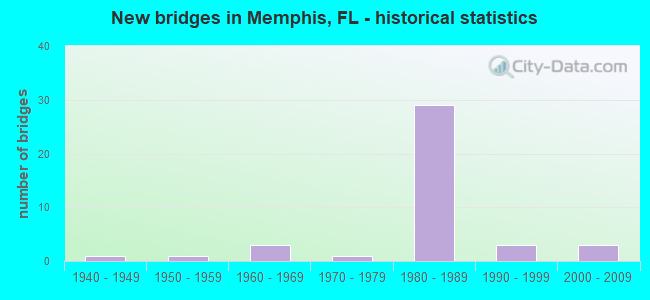
- New bridges - historical statistics
- 11940-1949
- 11950-1959
- 31960-1969
- 11970-1979
- 291980-1989
- 31990-1999
- 32000-2009

- Reconstructed bridges - Historical Statistics
- 11960-1969
- 01970-1979
- 11980-1989


- Bridge Condition - Deck
- 3.6%Very good
- 57.1%Good
- 35.7%Satisfactory
- 3.6%Fair

- Bridge Condition - Superstructure
- 14.3%Very good
- 67.9%Good
- 10.7%Satisfactory
- 7.1%Fair

- Bridge Condition - Substructure
- 3.6%Very good
- 85.7%Good
- 10.7%Satisfactory

- Bridge Condition - Channel
- 23.5%Excellent
- 35.3%Very good
- 41.2%Good
Find on map >> Show street view
Structure Number: 130019, Location: 1.4 MI N OF US-41 (Lat: 27.568039, Lng: -82.568731), Route carried "on" structure: US 19, Year Built: 1969, Status: Open, Structure Length: 10.30m (33.79ft), Average Daily Traffic: 10,250 (year 2020), Truck Traffic: 6%, Average Future Daily Traffic: 17,784 (year 2042), Design Load: HS 20, Features Intersected: TERRA CEIA BAY
Minimum Vertical Clearance: 30+ m (98+ ft), Kilometerpoint: 11.996, Lanes on structure: 2, Base Highway Network: Yes, Owner: State Highway Agency, Approaching Roadway Width: 12.3m (40.4ft), Material/Design: Prestressed concrete, Design/Construction: Stringer/Multi-beam, Number Of Spans In Main Unit: 7, Length of Maximum Span: 14.6m (47.9ft), Curb-To-Curb Width: 12.3m (40.4ft), Out-to-Out Width: 12.8m (42.0ft)
Condition: Deck: Satisfactory, Superstructure: Good, Substructure: Good, Channel: Excellent, Operating Rating: 55.3 metric tons, Method Used To Determine Operating Rating: Allowable Stress (AS), Inventory Rating: 49.0 metric tons, Method Used To Determine Inventory Rating: Allowable Stress (AS), Structural Evaluation: Better than present minimum criteria, Deck Geometry: Better than present minimum criteria, Waterway Adequacy: Equal to present desirable criteria, Approach Roadway Alignment: Equal to present desirable criteria, Designated Inspection Frequency: Every 24 months, Underwater Inspection Frequency: Every 24 months, Inspection Date: October 2021, Underwater Inspection Date: September 2021, Deck Structure Type: Concrete Cast-file-Place
Find on map >> Show street view
Structure Number: 130116, Location: 0.6MI W OF US-41 (Lat: 27.585186, Lng: -82.550281), Route carried "on" structure: Interstate 275, Year Built: 1983, Status: Open, Structure Length: 5.46m (17.91ft), Average Daily Traffic: 21,500 (year 2020), Truck Traffic: 8%, Average Future Daily Traffic: 37,302 (year 2042), Design Load: HS 20+Mod, Features Intersected: BAYSHORE ROAD
Minimum Vertical Clearance: 30+ m (98+ ft), Kilometerpoint: 4.633, Lanes on structure: 2, Lanes under structure: 2, Base Highway Network: Yes, Toll: On Interstate toll segment, Owner: State Highway Agency, Approaching Roadway Width: 11.0m (36.1ft), Skew: 3 degrees, Material/Design: Prestressed concrete, Design/Construction: Stringer/Multi-beam, Number Of Spans In Main Unit: 3, Length of Maximum Span: 22.6m (74.1ft), Curb-To-Curb Width: 12.1m (39.7ft), Out-to-Out Width: 13.0m (42.7ft)
Condition: Deck: Good, Superstructure: Good, Substructure: Good, Operating Rating: 49.9 metric tons, Method Used To Determine Operating Rating: Load Factor (LF), Inventory Rating: 29.9 metric tons, Method Used To Determine Inventory Rating: Load Factor (LF), Structural Evaluation: Better than present minimum criteria, Deck Geometry: Equal to present minimum criteria, Underclear: Superior to present desirable criteria, Approach Roadway Alignment: Equal to present desirable criteria, Designated Inspection Frequency: Every 24 months, Inspection Date: August 2020, Deck Structure Type: Concrete Cast-file-Place
Find on map >> Show street view
Structure Number: 130117, Location: 0.6MI WEST OF US-41 (Lat: 27.584881, Lng: -82.550500), Route carried "on" structure: Interstate 275, Year Built: 1983, Status: Open, Structure Length: 5.46m (17.91ft), Average Daily Traffic: 21,500 (year 2020), Truck Traffic: 8%, Average Future Daily Traffic: 37,302 (year 2042), Design Load: HS 20, Features Intersected: BAYSHORE ROAD
Minimum Vertical Clearance: 30+ m (98+ ft), Kilometerpoint: 4.659, Lanes on structure: 2, Lanes under structure: 2, Base Highway Network: Yes, Toll: On Interstate toll segment, Owner: State Highway Agency, Approaching Roadway Width: 11.0m (36.1ft), Skew: 3 degrees, Material/Design: Prestressed concrete, Design/Construction: Stringer/Multi-beam, Number Of Spans In Main Unit: 3, Length of Maximum Span: 22.6m (74.1ft), Curb-To-Curb Width: 12.1m (39.7ft), Out-to-Out Width: 13.0m (42.7ft)
Condition: Deck: Good, Superstructure: Good, Substructure: Good, Operating Rating: 49.9 metric tons, Method Used To Determine Operating Rating: Load Factor (LF), Inventory Rating: 29.9 metric tons, Method Used To Determine Inventory Rating: Load Factor (LF), Structural Evaluation: Better than present minimum criteria, Deck Geometry: Equal to present minimum criteria, Underclear: Better than present minimum criteria, Approach Roadway Alignment: Equal to present desirable criteria, Designated Inspection Frequency: Every 24 months, Inspection Date: August 2020, Deck Structure Type: Concrete Cast-file-Place
Find on map >> Show street view
Structure Number: 130118, Location: 2.2 MI WEST OF I-75 (Lat: 27.585469, Lng: -82.540358), Route carried "on" structure: Interstate 275, Year Built: 1984, Status: Open, Structure Length: 7.35m (24.11ft), Average Daily Traffic: 27,000 (year 2020), Truck Traffic: 9%, Average Future Daily Traffic: 46,845 (year 2042), Design Load: HS 20, Features Intersected: US-41/SR-45
Minimum Vertical Clearance: 30+ m (98+ ft), Kilometerpoint: 3.632, Lanes on structure: 2, Lanes under structure: 8, Base Highway Network: Yes, Toll: On Interstate toll segment, Owner: State Highway Agency, Approaching Roadway Width: 14.0m (45.9ft), Material/Design: Prestressed concrete, Design/Construction: Stringer/Multi-beam, Number Of Spans In Main Unit: 4, Length of Maximum Span: 26.8m (87.9ft), Curb-To-Curb Width: 12.1m (39.7ft), Out-to-Out Width: 13.0m (42.7ft)
Condition: Deck: Good, Superstructure: Good, Substructure: Good, Operating Rating: 53.2 metric tons, Method Used To Determine Operating Rating: Load Factor (LF), Inventory Rating: 31.8 metric tons, Method Used To Determine Inventory Rating: Load Factor (LF), Structural Evaluation: Better than present minimum criteria, Deck Geometry: Equal to present minimum criteria, Underclear: Equal to present minimum criteria, Approach Roadway Alignment: Equal to present desirable criteria, Designated Inspection Frequency: Every 24 months, Inspection Date: August 2020, Deck Structure Type: Concrete Cast-file-Place
Find on map >> Show street view
Structure Number: 130119, Location: 2.2 MI WEST OF I-75 (Lat: 27.585147, Lng: -82.540281), Route carried "on" structure: Interstate 275, Year Built: 1983, Status: Open, Structure Length: 7.35m (24.11ft), Average Daily Traffic: 27,000 (year 2020), Truck Traffic: 9%, Average Future Daily Traffic: 46,845 (year 2042), Design Load: HS 20, Features Intersected: US-41/SR-45
Minimum Vertical Clearance: 30+ m (98+ ft), Kilometerpoint: 3.632, Lanes on structure: 2, Lanes under structure: 8, Base Highway Network: Yes, Toll: On Interstate toll segment, Owner: State Highway Agency, Approaching Roadway Width: 11.1m (36.4ft), Material/Design: Prestressed concrete, Design/Construction: Stringer/Multi-beam, Number Of Spans In Main Unit: 4, Length of Maximum Span: 26.8m (87.9ft), Curb-To-Curb Width: 12.1m (39.7ft), Out-to-Out Width: 13.0m (42.7ft)
Condition: Deck: Good, Superstructure: Good, Substructure: Good, Operating Rating: 53.2 metric tons, Method Used To Determine Operating Rating: Load Factor (LF), Inventory Rating: 31.8 metric tons, Method Used To Determine Inventory Rating: Load Factor (LF), Structural Evaluation: Better than present minimum criteria, Deck Geometry: Equal to present minimum criteria, Underclear: Equal to present minimum criteria, Approach Roadway Alignment: Equal to present desirable criteria, Designated Inspection Frequency: Every 24 months, Inspection Date: August 2020, Deck Structure Type: Concrete Cast-file-Place
Find on map >> Show street view
Structure Number: 13012, Location: 0.3MI SOUTH OF US-41 (Lat: 27.585642, Lng: -82.535158), Route carried "on" structure: Interstate 275, Year Built: 1983, Status: Open, Structure Length: 4.30m (14.11ft), Average Daily Traffic: 27,000 (year 2020), Truck Traffic: 9%, Average Future Daily Traffic: 46,845 (year 2042), Design Load: HS 20+Mod, Features Intersected: FROG CREEK
Minimum Vertical Clearance: 30+ m (98+ ft), Kilometerpoint: 3.141, Lanes on structure: 3, Base Highway Network: Yes, Toll: On Interstate toll segment, Owner: State Highway Agency, Approaching Roadway Width: 15.3m (50.2ft), Material/Design: Prestressed concrete, Design/Construction: Stringer/Multi-beam, Number Of Spans In Main Unit: 3, Length of Maximum Span: 14.3m (46.9ft), Curb-To-Curb Width: 15.3m (50.2ft), Out-to-Out Width: 16.2m (53.1ft)
Condition: Deck: Satisfactory, Superstructure: Good, Substructure: Good, Channel: Excellent, Operating Rating: 54.4 metric tons, Method Used To Determine Operating Rating: Allowable Stress (AS), Inventory Rating: 48.1 metric tons, Method Used To Determine Inventory Rating: Allowable Stress (AS), Structural Evaluation: Better than present minimum criteria, Deck Geometry: Meets minimum limits, Waterway Adequacy: Better than present minimum criteria, Approach Roadway Alignment: Equal to present desirable criteria, Designated Inspection Frequency: Every 24 months, Inspection Date: August 2020, Deck Structure Type: Concrete Cast-file-Place
Find on map >> Show street view
Structure Number: 130121, Location: 0.3MI SOUTH OF US-41 (Lat: 27.585294, Lng: -82.535153), Route carried "on" structure: Interstate 275, Year Built: 1983, Status: Open, Structure Length: 4.30m (14.11ft), Average Daily Traffic: 27,000 (year 2020), Truck Traffic: 9%, Average Future Daily Traffic: 46,845 (year 2042), Design Load: HS 20+Mod, Features Intersected: FROG CREEK
Minimum Vertical Clearance: 30+ m (98+ ft), Kilometerpoint: 3.141, Lanes on structure: 3, Base Highway Network: Yes, Toll: On Interstate toll segment, Owner: State Highway Agency, Approaching Roadway Width: 17.1m (56.1ft), Material/Design: Prestressed concrete, Design/Construction: Stringer/Multi-beam, Number Of Spans In Main Unit: 3, Length of Maximum Span: 14.3m (46.9ft), Curb-To-Curb Width: 17.1m (56.1ft), Out-to-Out Width: 17.9m (58.7ft)
Condition: Deck: Satisfactory, Superstructure: Good, Substructure: Good, Channel: Good, Operating Rating: 59.2 metric tons, Method Used To Determine Operating Rating: Load Factor (LF), Inventory Rating: 35.5 metric tons, Method Used To Determine Inventory Rating: Load Factor (LF), Structural Evaluation: Better than present minimum criteria, Deck Geometry: Equal to present minimum criteria, Waterway Adequacy: Equal to present desirable criteria, Approach Roadway Alignment: Equal to present desirable criteria, Designated Inspection Frequency: Every 24 months, Inspection Date: August 2020, Deck Structure Type: Concrete Cast-file-Place
Find on map >> Show street view
Structure Number: 130123, Location: 0.3MI WEST OF US-41/SR-45 (Lat: 27.585364, Lng: -82.545108), Route carried "on" structure: Interstate 275, Year Built: 1983, Status: Open, Structure Length: 4.88m (16.01ft), Average Daily Traffic: 21,500 (year 2020), Truck Traffic: 8%, Average Future Daily Traffic: 37,302 (year 2042), Design Load: HS 20+Mod, Features Intersected: CSX RR
Minimum Vertical Clearance: 30+ m (98+ ft), Kilometerpoint: 4.118, Lanes on structure: 3, Base Highway Network: Yes, Toll: On Interstate toll segment, Owner: State Highway Agency, Approaching Roadway Width: 15.5m (50.9ft), Skew: 1 degrees, Material/Design: Prestressed concrete, Design/Construction: Stringer/Multi-beam, Number Of Spans In Main Unit: 3, Length of Maximum Span: 16.5m (54.1ft), Curb-To-Curb Width: 16.5m (54.1ft), Out-to-Out Width: 17.7m (58.1ft)
Condition: Deck: Satisfactory, Superstructure: Very good, Substructure: Good, Operating Rating: 46.3 metric tons, Method Used To Determine Operating Rating: Allowable Stress (AS), Inventory Rating: 41.7 metric tons, Method Used To Determine Inventory Rating: Allowable Stress (AS), Structural Evaluation: Better than present minimum criteria, Deck Geometry: Equal to present minimum criteria, Underclear: Better than present minimum criteria, Approach Roadway Alignment: Equal to present desirable criteria, Designated Inspection Frequency: Every 24 months, Inspection Date: August 2020, Deck Structure Type: Concrete Cast-file-Place
Find on map >> Show street view
Structure Number: 130124, Location: 0.3MI WEST OF US-41/SR-45 (Lat: 27.584994, Lng: -82.545194), Route carried "on" structure: Interstate 275, Year Built: 1983, Status: Open, Structure Length: 4.75m (15.58ft), Average Daily Traffic: 21,500 (year 2020), Truck Traffic: 8%, Average Future Daily Traffic: 37,302 (year 2042), Design Load: HS 20+Mod, Features Intersected: CSX RR
Minimum Vertical Clearance: 30+ m (98+ ft), Kilometerpoint: 4.133, Lanes on structure: 2, Base Highway Network: Yes, Toll: On Interstate toll segment, Owner: State Highway Agency, Approaching Roadway Width: 14.0m (45.9ft), Skew: 1 degrees, Material/Design: Prestressed concrete, Design/Construction: Stringer/Multi-beam, Number Of Spans In Main Unit: 3, Length of Maximum Span: 15.8m (51.8ft), Curb-To-Curb Width: 15.4m (50.5ft), Out-to-Out Width: 16.3m (53.5ft)
Condition: Deck: Good, Superstructure: Very good, Substructure: Good, Operating Rating: 46.3 metric tons, Method Used To Determine Operating Rating: Allowable Stress (AS), Inventory Rating: 41.7 metric tons, Method Used To Determine Inventory Rating: Allowable Stress (AS), Structural Evaluation: Better than present minimum criteria, Deck Geometry: Superior to present desirable criteria, Underclear: Better than present minimum criteria, Approach Roadway Alignment: Equal to present desirable criteria, Designated Inspection Frequency: Every 24 months, Inspection Date: August 2020, Deck Structure Type: Concrete Cast-file-Place
Find on map >> Show street view
Structure Number: 130125, Location: 1.5MI WEST OF US-41 (Lat: 27.580764, Lng: -82.566967), Route carried "on" structure: Interstate 275, Year Built: 1984, Status: Open, Structure Length: 5.58m (18.31ft), Average Daily Traffic: 21,500 (year 2020), Truck Traffic: 8%, Average Future Daily Traffic: 37,302 (year 2042), Design Load: HS 20+Mod, Features Intersected: ABEL ROAD
Minimum Vertical Clearance: 30+ m (98+ ft), Kilometerpoint: 6.362, Lanes on structure: 2, Lanes under structure: 2, Base Highway Network: Yes, Toll: On Interstate toll segment, Owner: State Highway Agency, Approaching Roadway Width: 12.1m (39.7ft), Skew: 1 degrees, Material/Design: Prestressed concrete, Design/Construction: Stringer/Multi-beam, Number Of Spans In Main Unit: 2, Length of Maximum Span: 28.0m (91.9ft), Curb-To-Curb Width: 12.1m (39.7ft), Out-to-Out Width: 13.0m (42.7ft)
Condition: Deck: Satisfactory, Superstructure: Good, Substructure: Good, Operating Rating: 69.9 metric tons, Method Used To Determine Operating Rating: Allowable Stress (AS), Inventory Rating: 61.7 metric tons, Method Used To Determine Inventory Rating: Allowable Stress (AS), Structural Evaluation: Better than present minimum criteria, Deck Geometry: Equal to present minimum criteria, Underclear: Equal to present minimum criteria, Approach Roadway Alignment: Equal to present desirable criteria, Designated Inspection Frequency: Every 24 months, Inspection Date: August 2020, Deck Structure Type: Concrete Cast-file-Place
Find on map >> Show street view
Structure Number: 130126, Location: 1.5MI WEST OF US-41 (Lat: 27.580439, Lng: -82.566844), Route carried "on" structure: Interstate 275, Year Built: 1984, Status: Open, Structure Length: 5.58m (18.31ft), Average Daily Traffic: 21,500 (year 2020), Truck Traffic: 8%, Average Future Daily Traffic: 37,302 (year 2042), Design Load: HS 20+Mod, Features Intersected: ABEL ROAD
Minimum Vertical Clearance: 30+ m (98+ ft), Kilometerpoint: 6.368, Lanes on structure: 2, Lanes under structure: 2, Base Highway Network: Yes, Toll: On Interstate toll segment, Owner: State Highway Agency, Approaching Roadway Width: 12.1m (39.7ft), Skew: 1 degrees, Material/Design: Prestressed concrete, Design/Construction: Stringer/Multi-beam, Number Of Spans In Main Unit: 2, Length of Maximum Span: 28.0m (91.9ft), Curb-To-Curb Width: 12.1m (39.7ft), Out-to-Out Width: 13.0m (42.7ft)
Condition: Deck: Satisfactory, Superstructure: Good, Substructure: Good, Operating Rating: 69.9 metric tons, Method Used To Determine Operating Rating: Allowable Stress (AS), Inventory Rating: 61.7 metric tons, Method Used To Determine Inventory Rating: Allowable Stress (AS), Structural Evaluation: Better than present minimum criteria, Deck Geometry: Equal to present minimum criteria, Underclear: Equal to present minimum criteria, Approach Roadway Alignment: Equal to present desirable criteria, Designated Inspection Frequency: Every 24 months, Inspection Date: August 2020, Deck Structure Type: Concrete Cast-file-Place
Find on map >> Show street view
Structure Number: 130127, Location: 2.1 MI WEST OF US-41 (Lat: 27.581764, Lng: -82.577917), Route carried "on" structure: Interstate 275, Year Built: 1984, Status: Open, Structure Length: 34.10m (111.88ft), Average Daily Traffic: 21,500 (year 2020), Truck Traffic: 8%, Average Future Daily Traffic: 37,302 (year 2042), Design Load: HS 20+Mod, Features Intersected: US-19/WILLIAMS BAYOU
Minimum Vertical Clearance: 5.82m (19.09ft), Kilometerpoint: 7.298, Lanes on structure: 2, Lanes under structure: 4, Base Highway Network: Yes, Toll: On Interstate toll segment, Owner: State Highway Agency, Approaching Roadway Width: 12.1m (39.7ft), Skew: 9 degrees, Material/Design: Prestressed concrete, Design/Construction: Stringer/Multi-beam, Number Of Spans In Main Unit: 12, Length of Maximum Span: 40.2m (131.9ft), Curb-To-Curb Width: 12.1m (39.7ft), Out-to-Out Width: 13.1m (43.0ft)
Condition: Deck: Good, Superstructure: Satisfactory, Substructure: Good, Channel: Very good, Operating Rating: 48.1 metric tons, Method Used To Determine Operating Rating: Allowable Stress (AS), Inventory Rating: 40.8 metric tons, Method Used To Determine Inventory Rating: Allowable Stress (AS), Structural Evaluation: Equal to present minimum criteria, Deck Geometry: Equal to present minimum criteria, Underclear: Better than present minimum criteria, Waterway Adequacy: Equal to present minimum criteria, Approach Roadway Alignment: Equal to present desirable criteria, Designated Inspection Frequency: Every 24 months, Inspection Date: August 2020, Deck Structure Type: Concrete Cast-file-Place
Find on map >> Show street view
Structure Number: 130128, Location: 2.1 MI WEST OF US-41 (Lat: 27.581333, Lng: -82.578703), Route carried "on" structure: Interstate 275, Year Built: 1984, Status: Open, Structure Length: 27.80m (91.21ft), Average Daily Traffic: 21,500 (year 2020), Truck Traffic: 8%, Average Future Daily Traffic: 37,302 (year 2042), Design Load: HS 20+Mod, Features Intersected: US-19/WILLIAMS BAYOU
Minimum Vertical Clearance: 30+ m (98+ ft), Kilometerpoint: 7.327, Lanes on structure: 2, Lanes under structure: 4, Base Highway Network: Yes, Toll: On Interstate toll segment, Owner: State Highway Agency, Approaching Roadway Width: 13.3m (43.6ft), Skew: 9 degrees, Material/Design: Prestressed concrete, Design/Construction: Stringer/Multi-beam, Number Of Spans In Main Unit: 10, Length of Maximum Span: 40.2m (131.9ft), Curb-To-Curb Width: 12.3m (40.4ft), Out-to-Out Width: 13.1m (43.0ft)
Condition: Deck: Good, Superstructure: Satisfactory, Substructure: Good, Channel: Very good, Operating Rating: 44.4 metric tons, Method Used To Determine Operating Rating: Load Factor (LF), Inventory Rating: 26.4 metric tons, Method Used To Determine Inventory Rating: Load Factor (LF), Structural Evaluation: Equal to present minimum criteria, Deck Geometry: Better than present minimum criteria, Underclear: Better than present minimum criteria, Waterway Adequacy: Equal to present desirable criteria, Approach Roadway Alignment: Equal to present desirable criteria, Designated Inspection Frequency: Every 24 months, Inspection Date: August 2020, Deck Structure Type: Concrete Cast-file-Place
Find on map >> Show street view
Structure Number: 130129, Location: 1.2MI. WEST OF US-41 (Lat: 27.582042, Lng: -82.563214), Route carried "on" structure: Interstate 275, Year Built: 1984, Status: Open, Structure Length: 55.47m (181.99ft), Average Daily Traffic: 21,500 (year 2020), Truck Traffic: 8%, Average Future Daily Traffic: 37,302 (year 2042), Design Load: HS 20+Mod, Features Intersected: TERRA CEIA RIVER
Minimum Vertical Clearance: 30+ m (98+ ft), Kilometerpoint: 5.718, Lanes on structure: 2, Base Highway Network: Yes, Toll: On Interstate toll segment, Owner: State Highway Agency, Approaching Roadway Width: 12.1m (39.7ft), Material/Design: Prestressed concrete, Design/Construction: Slab, Number Of Spans In Main Unit: 52, Length of Maximum Span: 10.7m (35.1ft), Curb-To-Curb Width: 12.1m (39.7ft), Out-to-Out Width: 13.1m (43.0ft)
Condition: Deck: Fair, Superstructure: Fair, Substructure: Good, Channel: Good, Inventory Rating: 41.5 metric tons, Method Used To Determine Inventory Rating: Load Factor (LF), Structural Evaluation: Somewhat better than minimum adequacy, Deck Geometry: Equal to present minimum criteria, Waterway Adequacy: Equal to present desirable criteria, Approach Roadway Alignment: Equal to present desirable criteria, Designated Inspection Frequency: Every 24 months, Underwater Inspection Frequency: Every 24 months, Inspection Date: August 2020, Underwater Inspection Date: July 2020, Deck Structure Type: Concrete Precast Panels, Wearing Surface/Protective System: Wearing Surface: Integral Concrete
Find on map >> Show street view
Structure Number: 13013, Location: 1.2 MI WEST OF US-41 (Lat: 27.581744, Lng: -82.563064), Route carried "on" structure: Interstate 275, Year Built: 1984, Status: Open, Structure Length: 51.21m (168.01ft), Average Daily Traffic: 21,500 (year 2020), Truck Traffic: 8%, Average Future Daily Traffic: 37,302 (year 2042), Design Load: HS 20+Mod, Features Intersected: TERRA CEIA RIVER
Minimum Vertical Clearance: 30+ m (98+ ft), Kilometerpoint: 5.739, Lanes on structure: 2, Base Highway Network: Yes, Toll: On Interstate toll segment, Owner: State Highway Agency, Approaching Roadway Width: 12.1m (39.7ft), Material/Design: Prestressed concrete, Design/Construction: Slab, Number Of Spans In Main Unit: 48, Length of Maximum Span: 10.7m (35.1ft), Curb-To-Curb Width: 12.1m (39.7ft), Out-to-Out Width: 13.1m (43.0ft)
Condition: Deck: Good, Superstructure: Good, Substructure: Good, Channel: Good, Inventory Rating: 40.8 metric tons, Method Used To Determine Inventory Rating: Load Factor (LF), Structural Evaluation: Better than present minimum criteria, Deck Geometry: Equal to present minimum criteria, Waterway Adequacy: Equal to present desirable criteria, Approach Roadway Alignment: Equal to present desirable criteria, Designated Inspection Frequency: Every 24 months, Underwater Inspection Frequency: Every 24 months, Inspection Date: August 2020, Underwater Inspection Date: July 2020, Deck Structure Type: Concrete Precast Panels, Wearing Surface/Protective System: Wearing Surface: Integral Concrete
Find on map >> Show street view
Structure Number: 130133, Location: 1.0 MI. EAST OF US-19 (Lat: 27.580503, Lng: -82.561614), Route carried "on" structure: City street , Year Built: 1985, Status: Posted for load-capacity, Structure Length: 6.95m (22.80ft), Average Daily Traffic: 702 (year 2018), Truck Traffic: 2%, Average Future Daily Traffic: 1,218 (year 2040), Design Load: HS 20, Features Intersected: TERRA CEIA BAYOU, Facility Carried by Structure: 77TH ST TERRA CEIA
Minimum Vertical Clearance: 30+ m (98+ ft), Kilometerpoint: 0.000, Lanes on structure: 2, Owner: County Highway Agency, Approaching Roadway Width: 7.3m (24.0ft), Material/Design: Concrete continuous, Design/Construction: Slab, Number Of Spans In Main Unit: 7, Length of Maximum Span: 10.3m (33.8ft), Curb-To-Curb Width: 12.2m (40.0ft), Out-to-Out Width: 13.0m (42.7ft)
Condition: Deck: Good, Superstructure: Good, Substructure: Good, Channel: Good, Operating Rating: 75.7 metric tons, Method Used To Determine Operating Rating: Load Factor (LF), Inventory Rating: 45.4 metric tons, Method Used To Determine Inventory Rating: Load Factor (LF), Structural Evaluation: Better than present minimum criteria, Deck Geometry: Equal to present desirable criteria, Waterway Adequacy: Equal to present desirable criteria, Approach Roadway Alignment: Better than present minimum criteria, Designated Inspection Frequency: Every 24 months, Inspection Date: March 2020, Deck Structure Type: Concrete Cast-file-Place
Find on map >> Show street view
Structure Number: 130138, Location: 1.0 MI N OF S. TOLL BOOTH (Lat: 27.583922, Lng: -82.613300), Route carried "on" structure: Interstate 275, Year Built: 1989, Status: Open, Structure Length: 2.38m (7.81ft), Average Daily Traffic: 32,000 (year 2020), Truck Traffic: 7%, Average Future Daily Traffic: 55,520 (year 2042), Design Load: HS 20+Mod, Features Intersected: S. REST AREA ACCESS RD
Minimum Vertical Clearance: 30+ m (98+ ft), Kilometerpoint: 17.391, Lanes on structure: 2, Lanes under structure: 2, Base Highway Network: Yes, Toll: On Interstate toll segment, Owner: State Highway Agency, Approaching Roadway Width: 12.1m (39.7ft), Material/Design: Prestressed concrete, Design/Construction: Stringer/Multi-beam, Number Of Spans In Main Unit: 1, Length of Maximum Span: 23.8m (78.1ft), Curb-To-Curb Width: 12.1m (39.7ft), Out-to-Out Width: 13.0m (42.7ft)
Condition: Deck: Good, Superstructure: Good, Substructure: Good, Operating Rating: 65.3 metric tons, Method Used To Determine Operating Rating: Allowable Stress (AS), Inventory Rating: 59.0 metric tons, Method Used To Determine Inventory Rating: Allowable Stress (AS), Structural Evaluation: Better than present minimum criteria, Deck Geometry: Equal to present minimum criteria, Underclear: Equal to present minimum criteria, Approach Roadway Alignment: Equal to present desirable criteria, Designated Inspection Frequency: Every 24 months, Inspection Date: January 2021, Deck Structure Type: Concrete Cast-file-Place
Find on map >> Show street view
Structure Number: 130139, Location: 0.7 MI S OF SKYWAY BRIDGE (Lat: 27.586775, Lng: -82.620364), Route carried "on" structure: Interstate 275, Year Built: 1990, Status: Open, Structure Length: 10.29m (33.76ft), Average Daily Traffic: 32,000 (year 2020), Truck Traffic: 7%, Average Future Daily Traffic: 55,520 (year 2042), Design Load: HS 20, Features Intersected: TAMPA BAY
Minimum Vertical Clearance: 30.45m (99.90ft), Kilometerpoint: 18.126, Lanes on structure: 3, Base Highway Network: Yes, Toll: On Interstate toll segment, Owner: State Highway Agency, Approaching Roadway Width: 14.6m (47.9ft), Navigation Control: Yes ( Vertical Clearance: 3.8m (12.5ft), Horizontal Clearance: 14.6m (47.9ft)), Material/Design: Prestressed concrete, Design/Construction: Stringer/Multi-beam, Number Of Spans In Main Unit: 7, Length of Maximum Span: 14.6m (47.9ft), Curb-To-Curb Width: 14.6m (47.9ft), Out-to-Out Width: 15.5m (50.9ft)
Condition: Deck: Good, Superstructure: Good, Substructure: Good, Channel: Excellent, Operating Rating: 57.2 metric tons, Method Used To Determine Operating Rating: Allowable Stress (AS), Inventory Rating: 45.4 metric tons, Method Used To Determine Inventory Rating: Allowable Stress (AS), Structural Evaluation: Better than present minimum criteria, Deck Geometry: Meets minimum limits, Waterway Adequacy: Equal to present desirable criteria, Approach Roadway Alignment: Equal to present desirable criteria, Length Of Structure Improvement: 10.24m (33.60ft), Designated Inspection Frequency: Every 24 months, Underwater Inspection Frequency: Every 24 months, Inspection Date: January 2021, Underwater Inspection Date: December 2020, Bridge Improvement Cost: $116,000, Roadway Improvement Cost: $12,000, Total Project Cost: $128,000, Deck Structure Type: Concrete Cast-file-Place
Find on map >> Show street view
Structure Number: 13014, Location: 1.0 MI N OF S. TOLL BOOTH (Lat: 27.583722, Lng: -82.613361), Route carried "on" structure: Interstate 275, Year Built: 1989, Status: Open, Structure Length: 2.38m (7.81ft), Average Daily Traffic: 32,000 (year 2020), Truck Traffic: 7%, Average Future Daily Traffic: 55,520 (year 2042), Design Load: HS 20+Mod, Features Intersected: S. REST AREA ACCESS ROAD
Minimum Vertical Clearance: 30+ m (98+ ft), Kilometerpoint: 17.391, Lanes on structure: 2, Lanes under structure: 2, Base Highway Network: Yes, Toll: On Interstate toll segment, Owner: State Highway Agency, Approaching Roadway Width: 12.1m (39.7ft), Material/Design: Prestressed concrete, Design/Construction: Stringer/Multi-beam, Number Of Spans In Main Unit: 1, Length of Maximum Span: 23.8m (78.1ft), Curb-To-Curb Width: 12.1m (39.7ft), Out-to-Out Width: 13.0m (42.7ft)
Condition: Deck: Good, Superstructure: Good, Substructure: Good, Operating Rating: 65.3 metric tons, Method Used To Determine Operating Rating: Allowable Stress (AS), Inventory Rating: 59.0 metric tons, Method Used To Determine Inventory Rating: Allowable Stress (AS), Structural Evaluation: Better than present minimum criteria, Deck Geometry: Equal to present minimum criteria, Underclear: Equal to present minimum criteria, Approach Roadway Alignment: Equal to present desirable criteria, Designated Inspection Frequency: Every 24 months, Inspection Date: January 2021, Deck Structure Type: Concrete Cast-file-Place
Find on map >> Show street view
Structure Number: 130141, Location: 0.7 MI S OF SKYWAY BRIDGE (Lat: 27.586436, Lng: -82.620644), Route carried "on" structure: ServiceOther road 275, Year Built: 1992, Status: Open, Structure Length: 10.24m (33.60ft), Average Daily Traffic: 300 (year 2021), Truck Traffic: 1%, Average Future Daily Traffic: 521 (year 2042), Design Load: HS 20, Features Intersected: TAMPA BAY, Facility Carried by Structure: ACCESS RD FISHPIER
Minimum Vertical Clearance: 30+ m (98+ ft), Kilometerpoint: 0.863, Lanes on structure: 2, Toll: On Interstate toll segment, Owner: State Highway Agency, Approaching Roadway Width: 11.6m (38.1ft), Navigation Control: Yes ( Vertical Clearance: 4.9m (16.1ft), Horizontal Clearance: 13.9m (45.6ft)), Material/Design: Prestressed concrete, Design/Construction: Stringer/Multi-beam, Number Of Spans In Main Unit: 7, Length of Maximum Span: 14.6m (47.9ft), Curb-To-Curb Width: 11.6m (38.1ft), Out-to-Out Width: 12.5m (41.0ft)
Condition: Deck: Satisfactory, Superstructure: Good, Substructure: Good, Channel: Very good, Operating Rating: 52.6 metric tons, Method Used To Determine Operating Rating: Allowable Stress (AS), Inventory Rating: 41.7 metric tons, Method Used To Determine Inventory Rating: Allowable Stress (AS), Structural Evaluation: Better than present minimum criteria, Deck Geometry: Superior to present desirable criteria, Waterway Adequacy: Equal to present desirable criteria, Approach Roadway Alignment: Equal to present desirable criteria, Length Of Structure Improvement: 10.24m (33.60ft), Designated Inspection Frequency: Every 24 months, Underwater Inspection Frequency: Every 24 months, Inspection Date: January 2021, Underwater Inspection Date: December 2020, Bridge Improvement Cost: $134,000, Roadway Improvement Cost: $13,000, Total Project Cost: $147,000, Deck Structure Type: Concrete Cast-file-Place, Wearing Surface/Protective System: Deck Protection: Epoxy Coated Reinforcing
Find on map >> Show street view
Structure Number: 13015, Location: 2.4 MI N OF US-301 (Lat: 27.552069, Lng: -82.563072), Route carried "on" structure: US 19, Year Built: 2000, Status: Open, Structure Length: 3.35m (10.99ft), Average Daily Traffic: 11,500 (year 2020), Truck Traffic: 6%, Average Future Daily Traffic: 19,952 (year 2042), Design Load: HS 20+Mod, Features Intersected: US-41 (SR-45)
Minimum Vertical Clearance: 30+ m (98+ ft), Kilometerpoint: 10.068, Lanes on structure: 2, Lanes under structure: 2, Base Highway Network: Yes, Owner: State Highway Agency, Approaching Roadway Width: 12.0m (39.4ft), Material/Design: Prestressed concrete, Design/Construction: Stringer/Multi-beam, Number Of Spans In Main Unit: 1, Length of Maximum Span: 33.5m (109.9ft), Curb-To-Curb Width: 12.0m (39.4ft), Out-to-Out Width: 12.9m (42.3ft)
Condition: Deck: Very good, Superstructure: Very good, Substructure: Very good, Inventory Rating: 73.7 metric tons, Method Used To Determine Inventory Rating: Load Factor (LF), Structural Evaluation: Equal to present desirable criteria, Deck Geometry: Better than present minimum criteria, Underclear: Better than present minimum criteria, Approach Roadway Alignment: Equal to present desirable criteria, Designated Inspection Frequency: Every 24 months, Inspection Date: October 2021, Deck Structure Type: Concrete Cast-file-Place
Find on map >> Show street view
Structure Number: 130151, Location: 1.4 MI N OF US-41 (Lat: 27.567856, Lng: -82.568828), Route carried "on" structure: US 19, Year Built: 2001, Status: Open, Structure Length: 10.24m (33.60ft), Average Daily Traffic: 10,250 (year 2020), Truck Traffic: 6%, Average Future Daily Traffic: 17,784 (year 2042), Design Load: HS 20+Mod, Features Intersected: TERRA CEIA BAY
Minimum Vertical Clearance: 30+ m (98+ ft), Kilometerpoint: 11.996, Lanes on structure: 2, Base Highway Network: Yes, Owner: State Highway Agency, Approaching Roadway Width: 12.0m (39.4ft), Material/Design: Prestressed concrete, Design/Construction: Stringer/Multi-beam, Number Of Spans In Main Unit: 7, Length of Maximum Span: 14.6m (47.9ft), Curb or Sidewalk Widths: Left: 1.6m (5.2ft), Right: 0.0m, Curb-To-Curb Width: 12.0m (39.4ft), Out-to-Out Width: 14.7m (48.2ft)
Condition: Deck: Good, Superstructure: Very good, Substructure: Good, Channel: Excellent, Operating Rating: 71.6 metric tons, Method Used To Determine Operating Rating: Load Factor (LF), Inventory Rating: 42.8 metric tons, Method Used To Determine Inventory Rating: Load Factor (LF), Structural Evaluation: Better than present minimum criteria, Deck Geometry: Better than present minimum criteria, Waterway Adequacy: Equal to present desirable criteria, Approach Roadway Alignment: Equal to present desirable criteria, Designated Inspection Frequency: Every 24 months, Underwater Inspection Frequency: Every 24 months, Inspection Date: October 2021, Underwater Inspection Date: September 2021, Deck Structure Type: Concrete Cast-file-Place
Find on map >> Show street view
Structure Number: 130951, Location: 0.7 MI S OF SKYWAY BRIDGE (Lat: 27.586592, Lng: -82.620494), Route carried "on" structure: Interstate 275, Year Built: 1968, Year Reconstructed: 1989, Status: Open, Structure Length: 10.29m (33.76ft), Average Daily Traffic: 32,000 (year 2020), Truck Traffic: 7%, Average Future Daily Traffic: 55,520 (year 2042), Design Load: HS 20+Mod, Features Intersected: TAMPA BAY
Minimum Vertical Clearance: 30+ m (98+ ft), Kilometerpoint: 18.126, Lanes on structure: 2, Base Highway Network: Yes, Toll: On Interstate toll segment, Owner: State Highway Agency, Approaching Roadway Width: 12.1m (39.7ft), Navigation Control: Yes ( Vertical Clearance: 3.8m (12.5ft), Horizontal Clearance: 13.9m (45.6ft)), Material/Design: Prestressed concrete, Design/Construction: Stringer/Multi-beam, Number Of Spans In Main Unit: 7, Length of Maximum Span: 14.7m (48.2ft), Curb-To-Curb Width: 12.1m (39.7ft), Out-to-Out Width: 13.1m (43.0ft)
Condition: Deck: Satisfactory, Superstructure: Good, Substructure: Satisfactory, Channel: Very good, Operating Rating: 51.0 metric tons, Method Used To Determine Operating Rating: Load Factor (LF), Inventory Rating: 30.4 metric tons, Method Used To Determine Inventory Rating: Load Factor (LF), Structural Evaluation: Equal to present minimum criteria, Deck Geometry: Equal to present minimum criteria, Waterway Adequacy: Better than present minimum criteria, Approach Roadway Alignment: Equal to present desirable criteria, Length Of Structure Improvement: 10.30m (33.79ft), Designated Inspection Frequency: Every 24 months, Underwater Inspection Frequency: Every 24 months, Inspection Date: January 2021, Underwater Inspection Date: December 2020, Bridge Improvement Cost: $21,000, Roadway Improvement Cost: $2,000, Total Project Cost: $23,000, Deck Structure Type: Concrete Cast-file-Place
Find on map >> Show street view
Structure Number: 134002, Location: 0.6 MI. SW OF US-41 (Lat: 27.591033, Lng: -82.552417), Route carried "on" structure: County highway , Year Built: 1950, Status: Posted for load, Structure Length: 2.32m (7.61ft), Average Daily Traffic: 130 (year 2018), Truck Traffic: 1%, Average Future Daily Traffic: 226 (year 2040), Features Intersected: FROG CREEK, Facility Carried by Structure: BISHOP HARBOR ROAD
Minimum Vertical Clearance: 30+ m (98+ ft), Kilometerpoint: 0.000, Lanes on structure: 2, Owner: County Highway Agency, Approaching Roadway Width: 6.7m (22.0ft), Material/Design: Concrete, Design/Construction: Slab, Number Of Spans In Main Unit: 5, Length of Maximum Span: 5.0m (16.4ft), Curb-To-Curb Width: 7.6m (24.9ft), Out-to-Out Width: 8.1m (26.6ft)
Condition: Deck: Satisfactory, Superstructure: Satisfactory, Substructure: Good, Channel: Good, Operating Rating: 37.5 metric tons, Method Used To Determine Operating Rating: Load Factor (LF), Inventory Rating: 22.5 metric tons, Method Used To Determine Inventory Rating: Load Factor (LF), Structural Evaluation: Equal to present minimum criteria, Deck Geometry: Somewhat better than minimum adequacy, Waterway Adequacy: Better than present minimum criteria, Approach Roadway Alignment: Meets minimum limits, Bridge Posting: Required (Relationship of Operating Rating to Maximum Legal Load: 0.1 - 9.9% below), Designated Inspection Frequency: Every 24 months, Underwater Inspection Frequency: Every 24 months, Other Special Inspection Frequency: Every 12 months, Inspection Date: March 2020, Underwater Inspection Date: Febuary 2020, Other Special Inspection Date: March 2021, Deck Structure Type: Concrete Cast-file-Place
Find on map >> Show street view
Structure Number: 134005, Location: 0.3 MI. EAST OF US-41 (Lat: 27.557878, Lng: -82.552297), Route carried "on" structure: County highway , Year Built: 1960, Status: Posted for load, Structure Length: 0.99m (3.25ft), Average Daily Traffic: 2,900 (year 2020), Truck Traffic: 5%, Average Future Daily Traffic: 5,032 (year 2042), Features Intersected: TERRA CEIA CREEK, Facility Carried by Structure: 49th St E EXP FARM
Minimum Vertical Clearance: 30+ m (98+ ft), Kilometerpoint: 1.213, Lanes on structure: 2, Owner: County Highway Agency, Approaching Roadway Width: 6.1m (20.0ft), Material/Design: Steel, Design/Construction: Stringer/Multi-beam, Number Of Spans In Main Unit: 1, Length of Maximum Span: 9.9m (32.5ft), Curb-To-Curb Width: 6.9m (22.6ft), Out-to-Out Width: 7.3m (24.0ft)
Condition: Deck: Satisfactory, Superstructure: Fair, Substructure: Good, Channel: Good, Operating Rating: 35.0 metric tons, Method Used To Determine Operating Rating: Load Factor (LF), Inventory Rating: 21.0 metric tons, Method Used To Determine Inventory Rating: Load Factor (LF), Structural Evaluation: Somewhat better than minimum adequacy, Deck Geometry: High priority of replacement, Waterway Adequacy: Equal to present minimum criteria, Approach Roadway Alignment: Equal to present desirable criteria, Bridge Posting: Required (Relationship of Operating Rating to Maximum Legal Load: 10.0 - 19.9% below), Designated Inspection Frequency: Every 24 months, Other Special Inspection Frequency: Every 12 months, Inspection Date: March 2020, Other Special Inspection Date: March 2021, Deck Structure Type: Concrete Cast-file-Place, Wearing Surface/Protective System: Wearing Surface: Bituminous
Find on map >> Show street view
Structure Number: 134006, Location: 0.7MI SW OF US-41 (Lat: 27.589575, Lng: -82.546283), Route carried "on" structure: County highway , Year Built: 1949, Year Reconstructed: 1960, Status: Posted for load-capacity, Structure Length: 2.51m (8.23ft), Average Daily Traffic: 1,272 (year 2018), Truck Traffic: 3%, Average Future Daily Traffic: 2,207 (year 2040), Design Load: H 15, Features Intersected: FROG CREEK, Facility Carried by Structure: BAYSHORE ROAD
Minimum Vertical Clearance: 30+ m (98+ ft), Kilometerpoint: 3.428, Lanes on structure: 2, Owner: County Highway Agency, Approaching Roadway Width: 8.5m (27.9ft), Material/Design: Concrete, Design/Construction: Slab, Number Of Spans In Main Unit: 5, Length of Maximum Span: 4.9m (16.1ft), Curb-To-Curb Width: 8.5m (27.9ft), Out-to-Out Width: 10.2m (33.5ft)
Condition: Deck: Good, Superstructure: Good, Substructure: Satisfactory, Channel: Good, Operating Rating: 67.2 metric tons, Method Used To Determine Operating Rating: Load Factor (LF), Inventory Rating: 40.3 metric tons, Method Used To Determine Inventory Rating: Load Factor (LF), Structural Evaluation: Equal to present minimum criteria, Deck Geometry: Somewhat better than minimum adequacy, Waterway Adequacy: Equal to present minimum criteria, Approach Roadway Alignment: Equal to present desirable criteria, Designated Inspection Frequency: Every 24 months, Underwater Inspection Frequency: Every 24 months, Inspection Date: March 2020, Underwater Inspection Date: Febuary 2020, Deck Structure Type: Concrete Cast-file-Place, Wearing Surface/Protective System: Wearing Surface: Bituminous
Find on map >> Show street view
Structure Number: 134007, Location: 0.4MI. N OF PALM VIEW RD. (Lat: 27.573883, Lng: -82.535911), Route carried "on" structure: City street , Year Built: 1970, Status: Posted for load-capacity, Structure Length: 0.98m (3.22ft), Average Daily Traffic: 389 (year 2018), Truck Traffic: 1%, Average Future Daily Traffic: 675 (year 2040), Design Load: HS 20, Features Intersected: MCMULLEN CREEK, Facility Carried by Structure: 28TH AVE. EAST
Minimum Vertical Clearance: 30+ m (98+ ft), Kilometerpoint: 2.575, Lanes on structure: 2, Owner: County Highway Agency, Approaching Roadway Width: 6.2m (20.3ft), Material/Design: Prestressed concrete, Design/Construction: Channel Beam, Number Of Spans In Main Unit: 1, Length of Maximum Span: 9.8m (32.2ft), Curb-To-Curb Width: 8.7m (28.5ft), Out-to-Out Width: 9.3m (30.5ft)
Condition: Deck: Good, Superstructure: Good, Substructure: Good, Channel: Very good, Operating Rating: 40.2 metric tons, Method Used To Determine Operating Rating: Load Factor (LF), Inventory Rating: 20.6 metric tons, Method Used To Determine Inventory Rating: Load Factor (LF), Structural Evaluation: Somewhat better than minimum adequacy, Deck Geometry: Equal to present minimum criteria, Waterway Adequacy: Better than present minimum criteria, Approach Roadway Alignment: Equal to present desirable criteria, Designated Inspection Frequency: Every 24 months, Inspection Date: March 2020, Deck Structure Type: Concrete Cast-file-Place, Wearing Surface/Protective System: Wearing Surface: Bituminous
Find on map >> Show street view
Structure Number: 134091, Location: 0.9 MI. NW OF US-41 (Lat: 27.575000, Lng: -82.555278), Route carried "on" structure: County highway , Year Built: 1990, Status: Open, Structure Length: 2.87m (9.42ft), Average Daily Traffic: 2,073 (year 2018), Truck Traffic: 4%, Average Future Daily Traffic: 3,597 (year 2040), Design Load: HS 20, Features Intersected: MCMULLEN CREEK, Facility Carried by Structure: BAYSHORE RD.
Minimum Vertical Clearance: 30+ m (98+ ft), Kilometerpoint: 1.513, Lanes on structure: 2, Owner: County Highway Agency, Approaching Roadway Width: 7.4m (24.3ft), Material/Design: Concrete continuous, Design/Construction: Slab, Number Of Spans In Main Unit: 3, Length of Maximum Span: 11.0m (36.1ft), Curb-To-Curb Width: 12.2m (40.0ft), Out-to-Out Width: 13.1m (43.0ft)
Condition: Deck: Good, Superstructure: Good, Substructure: Satisfactory, Channel: Very good, Operating Rating: 60.9 metric tons, Method Used To Determine Operating Rating: Load Factor (LF), Inventory Rating: 36.6 metric tons, Method Used To Determine Inventory Rating: Load Factor (LF), Structural Evaluation: Equal to present minimum criteria, Deck Geometry: Equal to present minimum criteria, Waterway Adequacy: Better than present minimum criteria, Approach Roadway Alignment: Equal to present desirable criteria, Designated Inspection Frequency: Every 24 months, Underwater Inspection Frequency: Every 24 months, Inspection Date: March 2020, Underwater Inspection Date: Febuary 2020, Deck Structure Type: Concrete Cast-file-Place
Find on map >> Show street view
Structure Number: 130116, Location: 0.6MI W OF US-41 (Lat: 27.585186, Lng: -82.550281), Route carried "under" structure: County highway , Year Built: 1983, Structure Length: 0. m, Average Daily Traffic: 700 (year 2020), Truck Traffic: 5%, Features Intersected: BAYSHORE ROAD, Facility Carried by Structure: I-275 NB
Minimum Vertical Clearance: 5.39m (17.68ft), Kilometerpoint: 0.000, Lanes on structure: 2, Lanes under structure: 2, Material/Design: Prestressed concrete, Design/Construction: Stringer/Multi-beam, Length of Maximum Span: 22.6m (74.1ft)
Find on map >> Show street view
Structure Number: 130117, Location: 0.6MI WEST OF US-41 (Lat: 27.584881, Lng: -82.550500), Route carried "under" structure: County highway , Year Built: 1983, Structure Length: 0. m, Average Daily Traffic: 700 (year 2020), Truck Traffic: 5%, Features Intersected: BAYSHORE ROAD, Facility Carried by Structure: I-275 SB
Minimum Vertical Clearance: 4.97m (16.31ft), Kilometerpoint: 0.000, Lanes on structure: 2, Lanes under structure: 2, Material/Design: Prestressed concrete, Design/Construction: Stringer/Multi-beam, Length of Maximum Span: 22.6m (74.1ft)
Find on map >> Show street view
Structure Number: 130118, Location: 2.2 MI WEST OF I-75 (Lat: 27.585469, Lng: -82.540358), Route carried "under" structure: US 41, Year Built: 1984, Structure Length: 0. m, Average Daily Traffic: 12,800 (year 2020), Truck Traffic: 13%, Features Intersected: US-41/SR-45, Facility Carried by Structure: I-275/SR-93 NB
Minimum Vertical Clearance: 4.91m (16.11ft), Kilometerpoint: 8.391, Lanes on structure: 2, Lanes under structure: 8, Material/Design: Prestressed concrete, Design/Construction: Stringer/Multi-beam, Length of Maximum Span: 26.8m (87.9ft)
Find on map >> Show street view
Structure Number: 130119, Location: 2.2 MI WEST OF I-75 (Lat: 27.585147, Lng: -82.540281), Route carried "under" structure: US 41, Year Built: 1983, Structure Length: 0. m, Average Daily Traffic: 30,000 (year 2020), Truck Traffic: 12%, Features Intersected: US-41/SR-45, Facility Carried by Structure: I-275/SR-93 SB
Minimum Vertical Clearance: 4.91m (16.11ft), Kilometerpoint: 8.356, Lanes on structure: 2, Lanes under structure: 8, Material/Design: Prestressed concrete, Design/Construction: Stringer/Multi-beam, Length of Maximum Span: 26.8m (87.9ft)
Find on map >> Show street view
Structure Number: 130125, Location: 1.5MI WEST OF US-41 (Lat: 27.580764, Lng: -82.566967), Route carried "under" structure: County highway , Year Built: 1984, Structure Length: 0. m, Average Daily Traffic: 101 (year 2020), Truck Traffic: 5%, Features Intersected: ABEL ROAD, Facility Carried by Structure: I-275 NB
Minimum Vertical Clearance: 4.69m (15.39ft), Kilometerpoint: 0.000, Lanes on structure: 2, Lanes under structure: 2, Material/Design: Prestressed concrete, Design/Construction: Stringer/Multi-beam, Length of Maximum Span: 28.0m (91.9ft)
Find on map >> Show street view
Structure Number: 130126, Location: 1.5MI WEST OF US-41 (Lat: 27.580439, Lng: -82.566844), Route carried "under" structure: County highway , Year Built: 1984, Structure Length: 0. m, Average Daily Traffic: 101 (year 2020), Truck Traffic: 5%, Features Intersected: ABEL ROAD, Facility Carried by Structure: I-275 SB
Minimum Vertical Clearance: 4.69m (15.39ft), Kilometerpoint: 0.000, Lanes on structure: 2, Lanes under structure: 2, Material/Design: Prestressed concrete, Design/Construction: Stringer/Multi-beam, Length of Maximum Span: 28.0m (91.9ft)
Find on map >> Show street view
Structure Number: 130127, Location: 2.1 MI WEST OF US-41 (Lat: 27.581764, Lng: -82.577917), Route carried "under" structure: US 19, Year Built: 1984, Structure Length: 0. m, Average Daily Traffic: 8,600 (year 2020), Truck Traffic: 12%, Features Intersected: US-19/WILLIAMS BAYOU, Facility Carried by Structure: I-275 NB
Minimum Vertical Clearance: 4.97m (16.31ft), Kilometerpoint: 13.898, Lanes on structure: 2, Lanes under structure: 2, Material/Design: Prestressed concrete, Design/Construction: Stringer/Multi-beam, Length of Maximum Span: 40.2m (131.9ft)
Find on map >> Show street view
Structure Number: 130127, Location: 2.1 MI WEST OF US-41 (Lat: 27.581764, Lng: -82.577917), Route carried "under" structure: County highway , Year Built: 1984, Structure Length: 0. m, Average Daily Traffic: 20 (year 2019), Features Intersected: US-19/WILLIAMS BAYOU, Facility Carried by Structure: I-275 NB
Minimum Vertical Clearance: 5.88m (19.29ft), Kilometerpoint: 0.000, Lanes on structure: 2, Lanes under structure: 2, Material/Design: Prestressed concrete, Design/Construction: Stringer/Multi-beam, Length of Maximum Span: 40.2m (131.9ft)
Find on map >> Show street view
Structure Number: 130128, Location: 2.1 MI WEST OF US-41 (Lat: 27.581333, Lng: -82.578703), Route carried "under" structure: US 19, Year Built: 1984, Structure Length: 0. m, Average Daily Traffic: 8,600 (year 2020), Truck Traffic: 12%, Features Intersected: US-19/WILLIAMS BAYOU, Facility Carried by Structure: I-275 SB
Minimum Vertical Clearance: 4.97m (16.31ft), Kilometerpoint: 13.847, Lanes on structure: 2, Lanes under structure: 2, Material/Design: Prestressed concrete, Design/Construction: Stringer/Multi-beam, Length of Maximum Span: 40.2m (131.9ft)
Find on map >> Show street view
Structure Number: 130128, Location: 2.1 MI WEST OF US-41 (Lat: 27.581333, Lng: -82.578703), Route carried "under" structure: County highway , Year Built: 1984, Structure Length: 0. m, Average Daily Traffic: 20 (year 2019), Features Intersected: US-19/WILLIAMS BAYOU, Facility Carried by Structure: I-275 SB
Minimum Vertical Clearance: 6.00m (19.69ft), Kilometerpoint: 0.000, Lanes on structure: 2, Lanes under structure: 2, Material/Design: Prestressed concrete, Design/Construction: Stringer/Multi-beam, Length of Maximum Span: 40.2m (131.9ft)
Find on map >> Show street view
Structure Number: 130138, Location: 1.0 MI N OF S. TOLL BOOTH (Lat: 27.583922, Lng: -82.613300), Route carried "under" structure: ServiceOther road , Year Built: 1989, Structure Length: 0. m, Average Daily Traffic: 5,160 (year 2019), Truck Traffic: 6%, Features Intersected: S. REST AREA ACCESS RD, Facility Carried by Structure: I-275 (US-19) NB
Minimum Vertical Clearance: 4.48m (14.70ft), Kilometerpoint: 0.000, Lanes on structure: 2, Lanes under structure: 2, Toll: On Interstate toll segment, Material/Design: Prestressed concrete, Design/Construction: Stringer/Multi-beam, Length of Maximum Span: 23.8m (78.1ft)
Find on map >> Show street view
Structure Number: 13014, Location: 1.0 MI N OF S. TOLL BOOTH (Lat: 27.583722, Lng: -82.613361), Route carried "under" structure: ServiceOther road , Year Built: 1989, Structure Length: 0. m, Average Daily Traffic: 10,000 (year 2019), Truck Traffic: 8%, Features Intersected: S. REST AREA ACCESS ROAD, Facility Carried by Structure: I-275 (US-19) SB
Minimum Vertical Clearance: 4.63m (15.19ft), Kilometerpoint: 0.000, Lanes on structure: 2, Lanes under structure: 2, Toll: On Interstate toll segment, Material/Design: Prestressed concrete, Design/Construction: Stringer/Multi-beam, Length of Maximum Span: 23.8m (78.1ft)
Find on map >> Show street view
Structure Number: 13015, Location: 2.4 MI N OF US-301 (Lat: 27.552069, Lng: -82.563072), Route carried "under" structure: US 41, Year Built: 2000, Structure Length: 0. m, Average Daily Traffic: 14,500 (year 2020), Truck Traffic: 7%, Features Intersected: US-41 (SR-45), Facility Carried by Structure: US-19 NB (SR-55)
Minimum Vertical Clearance: 4.82m (15.81ft), Kilometerpoint: 0.396, Lanes on structure: 2, Lanes under structure: 2, Material/Design: Prestressed concrete, Design/Construction: Stringer/Multi-beam, Length of Maximum Span: 33.5m (109.9ft)