Bridge Statistics for Meadowbrook, Virginia (VA)
Condition, Traffic, Stress, Structural Evaluation, Project Costs
- National Bridge Inventory (NBI) Statistics
- 38Number of bridges
- 417ft / 127mTotal length
- $4,064,000Total costs
- 698,691Total average daily traffic
- 24,760Total average daily truck traffic
- National Bridge Inventory (NBI) Registered Bridges for Meadowbrook
- No street view available for this location
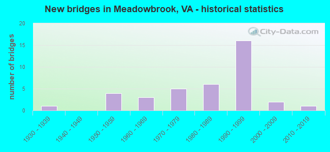
- New bridges - historical statistics
- 11930-1939
- 41950-1959
- 31960-1969
- 51970-1979
- 61980-1989
- 161990-1999
- 22000-2009
- 12010-2019

- Reconstructed bridges - Historical Statistics
- 11970-1979
- 11980-1989
- 41990-1999


- Bridge Condition - Deck
- 47.1%Good
- 35.3%Satisfactory
- 17.6%Fair

- Bridge Condition - Superstructure
- 5.9%Very good
- 35.3%Good
- 29.4%Satisfactory
- 23.5%Fair
- 5.9%Poor

- Bridge Condition - Substructure
- 23.5%Good
- 41.2%Satisfactory
- 29.4%Fair
- 5.9%Poor

- Bridge Condition - Channel
- 11.1%Good
- 33.3%Satisfactory
- 50.0%Fair
- 5.6%Poor
Find on map >> Show street view
Structure Number: 5002, Location: 0.49 FR.641 & 0.37 TO 701 (Lat: 37.403683, Lng: -77.507931), Route carried "on" structure: State highway 10, Year Built: 1959, Year Reconstructed: 1993, Status: Open, Structure Length: 0.73m (2.40ft), Average Daily Traffic: 25,921 (year 2020), Truck Traffic: 4%, Average Future Daily Traffic: 28,485 (year 2040), Design Load: HS 20, Features Intersected: BR PROCTOR CREEK, Facility Carried by Structure: IRONBRIDGE ROAD
Minimum Vertical Clearance: 30+ m (98+ ft), Kilometerpoint: 13.142, Lanes on structure: 4, Base Highway Network: Yes, Owner: State Highway Agency, Approaching Roadway Width: 31.7m (104.0ft), Skew: 2 degrees, Material/Design: Concrete, Design/Construction: Culvert, Number Of Spans In Main Unit: 2, Length of Maximum Span: 3.4m (11.2ft)
Condition: Channel: Fair, Culverts: Satisfactory, Operating Rating: 89.8 metric tons, Method Used To Determine Operating Rating: Field evaluation and documented engineering judgment, Inventory Rating: 89.8 metric tons, Method Used To Determine Inventory Rating: Field evaluation and documented engineering judgment, Structural Evaluation: Equal to present minimum criteria, Waterway Adequacy: Equal to present desirable criteria, Approach Roadway Alignment: Equal to present desirable criteria, Designated Inspection Frequency: Every 24 months, Inspection Date: March 2021
Find on map >> Show street view
Structure Number: 5007, Location: 0.20 Fr 701 & 0.20 To 288 (Lat: 37.395644, Lng: -77.514228), Route carried "on" structure: State highway 10, Year Built: 1990, Status: Open, Structure Length: 11.13m (36.52ft), Average Daily Traffic: 25,921 (year 2020), Truck Traffic: 4%, Average Future Daily Traffic: 28,485 (year 2040), Design Load: H 20, Features Intersected: UNNAMED TRIBUTARY
Minimum Vertical Clearance: 30+ m (98+ ft), Kilometerpoint: 14.375, Lanes on structure: 6, Base Highway Network: Yes, Owner: State Highway Agency, Approaching Roadway Width: 34.1m (111.9ft), Skew: 20 degrees, Material/Design: Steel, Design/Construction: Culvert, Number Of Spans In Main Unit: 4, Length of Maximum Span: 1.5m (4.9ft)
Condition: Channel: Satisfactory, Culverts: Satisfactory, Operating Rating: 44.5 metric tons, Method Used To Determine Operating Rating: Field evaluation and documented engineering judgment, Inventory Rating: 32.7 metric tons, Method Used To Determine Inventory Rating: Field evaluation and documented engineering judgment, Structural Evaluation: Equal to present minimum criteria, Waterway Adequacy: Equal to present desirable criteria, Approach Roadway Alignment: Equal to present desirable criteria, Designated Inspection Frequency: Every 24 months, Inspection Date: June 2020
Find on map >> Show street view
Structure Number: 5008, Location: .03 TO SCL RI &.33 FR 925 (Lat: 37.458725, Lng: -77.485981), Route carried "on" structure: State highway 10, Year Built: 1985, Status: Open, Structure Length: 4.57m (14.99ft), Average Daily Traffic: 6,012 (year 2020), Truck Traffic: 1%, Average Future Daily Traffic: 8,418 (year 2040), Design Load: HS 20+Mod, Features Intersected: FALLING CREEK
Minimum Vertical Clearance: 30+ m (98+ ft), Kilometerpoint: 6.327, Lanes on structure: 2, Base Highway Network: Yes, Owner: State Highway Agency, Approaching Roadway Width: 12.2m (40.0ft), Skew: 2 degrees, Material/Design: Steel, Design/Construction: Stringer/Multi-beam, Number Of Spans In Main Unit: 3, Length of Maximum Span: 15.2m (49.9ft), Curb-To-Curb Width: 9.5m (31.2ft), Out-to-Out Width: 12.3m (40.4ft)
Condition: Deck: Satisfactory, Superstructure: Fair, Substructure: Fair, Channel: Satisfactory, Operating Rating: 76.2 metric tons, Method Used To Determine Operating Rating: Load and Resistance Factor (LRFR), Inventory Rating: 59.0 metric tons, Method Used To Determine Inventory Rating: Load and Resistance Factor (LRFR), Structural Evaluation: Somewhat better than minimum adequacy, Deck Geometry: Meets minimum limits, Waterway Adequacy: Equal to present desirable criteria, Approach Roadway Alignment: Equal to present desirable criteria, Designated Inspection Frequency: Every 24 months, Underwater Inspection Frequency: Every 48 months, Inspection Date: June 2021, Underwater Inspection Date: June 2021, Deck Structure Type: Concrete Precast Panels, Wearing Surface/Protective System: Deck Protection: Epoxy Coated Reinforcing
Find on map >> Show street view
Structure Number: 5009, Location: .03 TO SCL RI& .33 FR 925 (Lat: 37.458575, Lng: -77.486175), Route carried "on" structure: State highway 10, Year Built: 1985, Status: Open, Structure Length: 4.57m (14.99ft), Average Daily Traffic: 6,012 (year 2020), Truck Traffic: 1%, Average Future Daily Traffic: 8,418 (year 2040), Design Load: HS 20+Mod, Features Intersected: FALLING CREEK
Minimum Vertical Clearance: 30+ m (98+ ft), Kilometerpoint: 6.327, Lanes on structure: 2, Base Highway Network: Yes, Owner: State Highway Agency, Approaching Roadway Width: 12.2m (40.0ft), Skew: 2 degrees, Material/Design: Steel, Design/Construction: Stringer/Multi-beam, Number Of Spans In Main Unit: 3, Length of Maximum Span: 15.2m (49.9ft), Curb or Sidewalk Widths: Left: 2.0m (6.6ft), Right: 0.2m (0.7ft), Curb-To-Curb Width: 9.5m (31.2ft), Out-to-Out Width: 12.3m (40.4ft)
Condition: Deck: Good, Superstructure: Satisfactory, Substructure: Fair, Channel: Fair, Operating Rating: 76.2 metric tons, Method Used To Determine Operating Rating: Load and Resistance Factor (LRFR), Inventory Rating: 58.1 metric tons, Method Used To Determine Inventory Rating: Load and Resistance Factor (LRFR), Structural Evaluation: Somewhat better than minimum adequacy, Deck Geometry: Meets minimum limits, Waterway Adequacy: Equal to present desirable criteria, Approach Roadway Alignment: Equal to present desirable criteria, Designated Inspection Frequency: Every 24 months, Underwater Inspection Frequency: Every 24 months, Inspection Date: June 2021, Underwater Inspection Date: June 2021, Deck Structure Type: Concrete Precast Panels, Wearing Surface/Protective System: Deck Protection: Epoxy Coated Reinforcing
Find on map >> Show street view
Structure Number: 5105, Location: 0.57 Fr 1601& .14 To 1607 (Lat: 37.441564, Lng: -77.453544), Route carried "on" structure: State highway 150, Year Built: 1965, Year Reconstructed: 2002, Status: Open, Structure Length: 6.16m (20.21ft), Average Daily Traffic: 27,935 (year 2020), Truck Traffic: 2%, Average Future Daily Traffic: 39,109 (year 2040), Design Load: HS 20+Mod, Features Intersected: CSX TRANS & STRATHMOR RD, Facility Carried by Structure: CHIPPENHAM PKWY WB
Minimum Vertical Clearance: 30+ m (98+ ft), Kilometerpoint: 21.078, Lanes on structure: 4, Lanes under structure: 2, Base Highway Network: Yes, Owner: State Highway Agency, Approaching Roadway Width: 22.6m (74.1ft), Skew: 2 degrees, Material/Design: Steel, Design/Construction: Stringer/Multi-beam, Number Of Spans In Main Unit: 4, Length of Maximum Span: 17.7m (58.1ft), Curb-To-Curb Width: 19.6m (64.3ft), Out-to-Out Width: 20.5m (67.3ft)
Condition: Deck: Satisfactory, Superstructure: Satisfactory, Substructure: Satisfactory, Operating Rating: 57.2 metric tons, Method Used To Determine Operating Rating: Load and Resistance Factor (LRFR), Inventory Rating: 43.5 metric tons, Method Used To Determine Inventory Rating: Load and Resistance Factor (LRFR), Structural Evaluation: Equal to present minimum criteria, Deck Geometry: Somewhat better than minimum adequacy, Underclear: Meets minimum limits, Approach Roadway Alignment: Equal to present desirable criteria, Length Of Structure Improvement: 6.10m (20.01ft), Designated Inspection Frequency: Every 24 months, Inspection Date: October 2020, Bridge Improvement Cost: $350,000, Roadway Improvement Cost: $50,000, Total Project Cost: $425,000, Deck Structure Type: Concrete Cast-file-Place, Wearing Surface/Protective System: Wearing Surface: Latex Concrete, Deck Protection: Epoxy Coated Reinforcing
Find on map >> Show street view
Structure Number: 5127, Location: 0.57 Fr 1601& .14 To 1607 (Lat: 37.441433, Lng: -77.453553), Route carried "on" structure: State highway 150, Year Built: 1976, Year Reconstructed: 2002, Status: Open, Structure Length: 6.16m (20.21ft), Average Daily Traffic: 27,935 (year 2020), Truck Traffic: 2%, Average Future Daily Traffic: 39,109 (year 2040), Design Load: HS 20+Mod, Features Intersected: CSX TRANS & STRATHMOR RD, Facility Carried by Structure: CHIPPENHAM PKWY EB
Minimum Vertical Clearance: 30+ m (98+ ft), Kilometerpoint: 21.078, Lanes on structure: 3, Lanes under structure: 2, Base Highway Network: Yes, Owner: State Highway Agency, Approaching Roadway Width: 17.1m (56.1ft), Skew: 2 degrees, Material/Design: Steel, Design/Construction: Stringer/Multi-beam, Number Of Spans In Main Unit: 4, Length of Maximum Span: 17.7m (58.1ft), Curb-To-Curb Width: 16.0m (52.5ft), Out-to-Out Width: 17.1m (56.1ft)
Condition: Deck: Satisfactory, Superstructure: Fair, Substructure: Satisfactory, Operating Rating: 64.4 metric tons, Method Used To Determine Operating Rating: Load and Resistance Factor (LRFR), Inventory Rating: 49.0 metric tons, Method Used To Determine Inventory Rating: Load and Resistance Factor (LRFR), Structural Evaluation: Somewhat better than minimum adequacy, Deck Geometry: Equal to present minimum criteria, Underclear: Meets minimum limits, Approach Roadway Alignment: Equal to present desirable criteria, Length Of Structure Improvement: 6.10m (20.01ft), Designated Inspection Frequency: Every 24 months, Inspection Date: October 2020, Bridge Improvement Cost: $350,000, Roadway Improvement Cost: $50,000, Total Project Cost: $425,000, Deck Structure Type: Concrete Cast-file-Place, Wearing Surface/Protective System: Wearing Surface: Latex Concrete, Deck Protection: Epoxy Coated Reinforcing
Find on map >> Show street view
Structure Number: 5136, Location: 0.87 Fr 651& 0.93 To 637 (Lat: 37.450881, Lng: -77.487000), Route carried "on" structure: State highway 150, Year Built: 1982, Year Reconstructed: 2002, Status: Open, Structure Length: 6.28m (20.60ft), Average Daily Traffic: 27,952 (year 2020), Truck Traffic: 2%, Average Future Daily Traffic: 39,134 (year 2040), Design Load: HS 20+Mod, Features Intersected: ROUTE 10, Facility Carried by Structure: CHIPPENHAM PKWY WB
Minimum Vertical Clearance: 30+ m (98+ ft), Kilometerpoint: 17.602, Lanes on structure: 4, Lanes under structure: 6, Base Highway Network: Yes, Owner: State Highway Agency, Approaching Roadway Width: 19.8m (65.0ft), Skew: 2 degrees, Material/Design: Steel continuous, Design/Construction: Stringer/Multi-beam, Number Of Spans In Main Unit: 2, Length of Maximum Span: 30.7m (100.7ft), Curb-To-Curb Width: 19.4m (63.6ft), Out-to-Out Width: 20.3m (66.6ft)
Condition: Deck: Good, Superstructure: Good, Substructure: Fair, Operating Rating: 80.7 metric tons, Method Used To Determine Operating Rating: Load and Resistance Factor (LRFR), Inventory Rating: 62.6 metric tons, Method Used To Determine Inventory Rating: Load and Resistance Factor (LRFR), Structural Evaluation: Somewhat better than minimum adequacy, Deck Geometry: Somewhat better than minimum adequacy, Underclear: Meets minimum limits, Approach Roadway Alignment: Equal to present desirable criteria, Designated Inspection Frequency: Every 24 months, Inspection Date: September 2020, Deck Structure Type: Concrete Cast-file-Place, Wearing Surface/Protective System: Wearing Surface: Latex Concrete, Deck Protection: Epoxy Coated Reinforcing
Find on map >> Show street view
Structure Number: 5138, Location: 0.87 Fr 651 & 0.93 To 637 (Lat: 37.450653, Lng: -77.486997), Route carried "on" structure: State highway 150, Year Built: 1982, Year Reconstructed: 2002, Status: Open, Structure Length: 6.28m (20.60ft), Average Daily Traffic: 27,952 (year 2020), Truck Traffic: 2%, Average Future Daily Traffic: 39,134 (year 2040), Design Load: HS 20+Mod, Features Intersected: ROUTE 10, Facility Carried by Structure: CHIPPENHAM PKWY EB
Minimum Vertical Clearance: 30+ m (98+ ft), Kilometerpoint: 17.602, Lanes on structure: 4, Lanes under structure: 6, Base Highway Network: Yes, Owner: State Highway Agency, Approaching Roadway Width: 19.8m (65.0ft), Skew: 2 degrees, Material/Design: Steel continuous, Design/Construction: Stringer/Multi-beam, Number Of Spans In Main Unit: 2, Length of Maximum Span: 30.7m (100.7ft), Curb-To-Curb Width: 19.4m (63.6ft), Out-to-Out Width: 20.3m (66.6ft)
Condition: Deck: Good, Superstructure: Good, Substructure: Fair, Operating Rating: 79.8 metric tons, Method Used To Determine Operating Rating: Load and Resistance Factor (LRFR), Inventory Rating: 61.7 metric tons, Method Used To Determine Inventory Rating: Load and Resistance Factor (LRFR), Structural Evaluation: Somewhat better than minimum adequacy, Deck Geometry: Somewhat better than minimum adequacy, Underclear: Meets minimum limits, Approach Roadway Alignment: Equal to present desirable criteria, Designated Inspection Frequency: Every 24 months, Inspection Date: September 2020, Deck Structure Type: Concrete Cast-file-Place, Wearing Surface/Protective System: Wearing Surface: Latex Concrete, Deck Protection: Epoxy Coated Reinforcing
Find on map >> Show street view
Structure Number: 5155, Location: 1.90 Fr 10 & 1.19 To 604 (Lat: 37.407369, Lng: -77.545353), Route carried "on" structure: State highway 288, Year Built: 1990, Status: Open, Structure Length: 0.79m (2.59ft), Average Daily Traffic: 23,583 (year 2020), Truck Traffic: 5%, Average Future Daily Traffic: 33,016 (year 2040), Design Load: HS 20+Mod, Features Intersected: TRIB. TO LICKING CREEK
Minimum Vertical Clearance: 30+ m (98+ ft), Kilometerpoint: 13.693, Lanes on structure: 2, Base Highway Network: Yes, Owner: State Highway Agency, Approaching Roadway Width: 12.5m (41.0ft), Skew: 1 degrees, Material/Design: Concrete, Design/Construction: Culvert, Number Of Spans In Main Unit: 3, Length of Maximum Span: 2.4m (7.9ft)
Condition: Channel: Fair, Culverts: Satisfactory, Operating Rating: 54.4 metric tons, Method Used To Determine Operating Rating: Field evaluation and documented engineering judgment, Inventory Rating: 32.7 metric tons, Method Used To Determine Inventory Rating: Field evaluation and documented engineering judgment, Structural Evaluation: Equal to present minimum criteria, Waterway Adequacy: Equal to present desirable criteria, Approach Roadway Alignment: Equal to present desirable criteria, Designated Inspection Frequency: Every 24 months, Inspection Date: March 2022
Find on map >> Show street view
Structure Number: 5189, Location: 2.30 Fr 145 & 1.48 To 10 (Lat: 37.393447, Lng: -77.483483), Route carried "on" structure: State highway 288, Year Built: 1990, Status: Open, Structure Length: 3.11m (10.20ft), Average Daily Traffic: 19,185 (year 2020), Truck Traffic: 5%, Average Future Daily Traffic: 26,859 (year 2040), Design Load: HS 20+Mod, Features Intersected: ROUTE 642
Minimum Vertical Clearance: 30+ m (98+ ft), Kilometerpoint: 8.238, Lanes on structure: 2, Lanes under structure: 2, Base Highway Network: Yes, Owner: State Highway Agency, Approaching Roadway Width: 12.5m (41.0ft), Material/Design: Steel, Design/Construction: Stringer/Multi-beam, Number Of Spans In Main Unit: 1, Length of Maximum Span: 29.9m (98.1ft), Curb-To-Curb Width: 11.7m (38.4ft), Out-to-Out Width: 12.7m (41.7ft)
Condition: Deck: Good, Superstructure: Good, Substructure: Good, Operating Rating: 86.2 metric tons, Method Used To Determine Operating Rating: Load and Resistance Factor (LRFR), Inventory Rating: 66.2 metric tons, Method Used To Determine Inventory Rating: Load and Resistance Factor (LRFR), Structural Evaluation: Better than present minimum criteria, Deck Geometry: Equal to present minimum criteria, Underclear: Better than present minimum criteria, Approach Roadway Alignment: Equal to present desirable criteria, Designated Inspection Frequency: Every 24 months, Inspection Date: June 2020, Deck Structure Type: Concrete Cast-file-Place, Wearing Surface/Protective System: Deck Protection: Epoxy Coated Reinforcing
Find on map >> Show street view
Structure Number: 5191, Location: 2.30 Fr 145 & 1.48 To 10 (Lat: 37.392981, Lng: -77.483469), Route carried "on" structure: State highway 288, Year Built: 1990, Status: Open, Structure Length: 3.11m (10.20ft), Average Daily Traffic: 19,185 (year 2020), Truck Traffic: 5%, Average Future Daily Traffic: 26,859 (year 2040), Design Load: HS 20+Mod, Features Intersected: ROUTE 642
Minimum Vertical Clearance: 30+ m (98+ ft), Kilometerpoint: 8.238, Lanes on structure: 2, Lanes under structure: 2, Base Highway Network: Yes, Owner: State Highway Agency, Approaching Roadway Width: 12.5m (41.0ft), Material/Design: Steel, Design/Construction: Stringer/Multi-beam, Number Of Spans In Main Unit: 1, Length of Maximum Span: 29.9m (98.1ft), Curb-To-Curb Width: 11.7m (38.4ft), Out-to-Out Width: 12.7m (41.7ft)
Condition: Deck: Good, Superstructure: Good, Substructure: Good, Operating Rating: 86.2 metric tons, Method Used To Determine Operating Rating: Load and Resistance Factor (LRFR), Inventory Rating: 66.2 metric tons, Method Used To Determine Inventory Rating: Load and Resistance Factor (LRFR), Structural Evaluation: Better than present minimum criteria, Deck Geometry: Equal to present minimum criteria, Underclear: Superior to present desirable criteria, Approach Roadway Alignment: Equal to present desirable criteria, Designated Inspection Frequency: Every 24 months, Inspection Date: June 2020, Deck Structure Type: Concrete Cast-file-Place, Wearing Surface/Protective System: Deck Protection: Epoxy Coated Reinforcing
Find on map >> Show street view
Structure Number: 5197, Location: 3.79 Fr 145 & 3.09 To 604 (Lat: 37.393094, Lng: -77.515044), Route carried "on" structure: State highway 288, Year Built: 1990, Status: Open, Structure Length: 6.34m (20.80ft), Average Daily Traffic: 23,583 (year 2020), Truck Traffic: 5%, Average Future Daily Traffic: 33,016 (year 2040), Design Load: HS 20+Mod, Features Intersected: ROUTE 10
Minimum Vertical Clearance: 30+ m (98+ ft), Kilometerpoint: 10.635, Lanes on structure: 3, Lanes under structure: 6, Base Highway Network: Yes, Owner: State Highway Agency, Approaching Roadway Width: 16.2m (53.1ft), Material/Design: Steel continuous, Design/Construction: Stringer/Multi-beam, Number Of Spans In Main Unit: 2, Length of Maximum Span: 31.7m (104.0ft), Curb-To-Curb Width: 16.0m (52.5ft), Out-to-Out Width: 17.0m (55.8ft)
Condition: Deck: Good, Superstructure: Satisfactory, Substructure: Satisfactory, Operating Rating: 88.0 metric tons, Method Used To Determine Operating Rating: Load and Resistance Factor (LRFR), Inventory Rating: 68.0 metric tons, Method Used To Determine Inventory Rating: Load and Resistance Factor (LRFR), Structural Evaluation: Equal to present minimum criteria, Deck Geometry: Equal to present minimum criteria, Underclear: Better than present minimum criteria, Approach Roadway Alignment: Equal to present desirable criteria, Designated Inspection Frequency: Every 24 months, Inspection Date: May 2020, Deck Structure Type: Concrete Cast-file-Place, Wearing Surface/Protective System: Deck Protection: Epoxy Coated Reinforcing
Find on map >> Show street view
Structure Number: 5199, Location: 3.79 Fr 145 & 3.09 To 604 (Lat: 37.393647, Lng: -77.514856), Route carried "on" structure: State highway 288, Year Built: 1990, Status: Open, Structure Length: 6.34m (20.80ft), Average Daily Traffic: 23,583 (year 2020), Truck Traffic: 5%, Average Future Daily Traffic: 33,016 (year 2040), Design Load: HS 20+Mod, Features Intersected: ROUTE 10
Minimum Vertical Clearance: 30+ m (98+ ft), Kilometerpoint: 10.635, Lanes on structure: 3, Lanes under structure: 6, Base Highway Network: Yes, Owner: State Highway Agency, Approaching Roadway Width: 16.2m (53.1ft), Material/Design: Steel continuous, Design/Construction: Stringer/Multi-beam, Number Of Spans In Main Unit: 2, Length of Maximum Span: 31.7m (104.0ft), Curb-To-Curb Width: 16.0m (52.5ft), Out-to-Out Width: 17.0m (55.8ft)
Condition: Deck: Good, Superstructure: Satisfactory, Substructure: Satisfactory, Operating Rating: 88.0 metric tons, Method Used To Determine Operating Rating: Load and Resistance Factor (LRFR), Inventory Rating: 68.0 metric tons, Method Used To Determine Inventory Rating: Load and Resistance Factor (LRFR), Structural Evaluation: Equal to present minimum criteria, Deck Geometry: Equal to present minimum criteria, Underclear: Better than present minimum criteria, Approach Roadway Alignment: Equal to present desirable criteria, Designated Inspection Frequency: Every 24 months, Inspection Date: May 2020, Deck Structure Type: Concrete Cast-file-Place, Wearing Surface/Protective System: Deck Protection: Epoxy Coated Reinforcing
Find on map >> Show street view
Structure Number: 5201, Location: 2.10 Fr 145 & 1.70 To 10 (Lat: 37.393400, Lng: -77.484661), Route carried "on" structure: State highway 288, Year Built: 1990, Status: Open, Structure Length: 17.01m (55.81ft), Average Daily Traffic: 38,370 (year 2020), Truck Traffic: 5%, Average Future Daily Traffic: 53,718 (year 2040), Design Load: HS 20+Mod, Features Intersected: PROCTORS CREEK
Minimum Vertical Clearance: 30+ m (98+ ft), Kilometerpoint: 7.916, Lanes on structure: 6, Base Highway Network: Yes, Owner: State Highway Agency, Approaching Roadway Width: 36.6m (120.1ft), Skew: 24 degrees, Material/Design: Concrete, Design/Construction: Culvert, Number Of Spans In Main Unit: 4, Length of Maximum Span: 4.3m (14.1ft)
Condition: Channel: Satisfactory, Culverts: Satisfactory, Operating Rating: 89.8 metric tons, Method Used To Determine Operating Rating: Field evaluation and documented engineering judgment, Inventory Rating: 89.8 metric tons, Method Used To Determine Inventory Rating: Field evaluation and documented engineering judgment, Structural Evaluation: Equal to present minimum criteria, Waterway Adequacy: Equal to present desirable criteria, Approach Roadway Alignment: Equal to present desirable criteria, Designated Inspection Frequency: Every 24 months, Inspection Date: June 2020
Find on map >> Show street view
Structure Number: 5202, Location: 1.20 Fr 145 & 2.59 To 10 (Lat: 37.393972, Lng: -77.470378), Route carried "on" structure: State highway 288, Year Built: 1990, Status: Open, Structure Length: 1.04m (3.41ft), Average Daily Traffic: 38,370 (year 2020), Truck Traffic: 5%, Average Future Daily Traffic: 53,718 (year 2040), Design Load: HS 20+Mod, Features Intersected: PROCTORS CREEK
Minimum Vertical Clearance: 30+ m (98+ ft), Kilometerpoint: 6.468, Lanes on structure: 4, Base Highway Network: Yes, Owner: State Highway Agency, Approaching Roadway Width: 24.4m (80.1ft), Skew: 25 degrees, Material/Design: Concrete, Design/Construction: Culvert, Number Of Spans In Main Unit: 2, Length of Maximum Span: 4.9m (16.1ft)
Condition: Channel: Fair, Culverts: Satisfactory, Operating Rating: 89.8 metric tons, Method Used To Determine Operating Rating: Field evaluation and documented engineering judgment, Inventory Rating: 89.8 metric tons, Method Used To Determine Inventory Rating: Field evaluation and documented engineering judgment, Structural Evaluation: Equal to present minimum criteria, Waterway Adequacy: Equal to present desirable criteria, Approach Roadway Alignment: Equal to present desirable criteria, Designated Inspection Frequency: Every 24 months, Inspection Date: May 2020
Find on map >> Show street view
Structure Number: 5204, Location: 1.40 Fr 145 & 2.30 To 10 (Lat: 37.393831, Lng: -77.474131), Route carried "on" structure: State highway 288, Year Built: 1990, Status: Open, Structure Length: 1.89m (6.20ft), Average Daily Traffic: 38,370 (year 2020), Truck Traffic: 5%, Average Future Daily Traffic: 53,718 (year 2040), Design Load: HS 20+Mod, Features Intersected: BRANCH OF PROCTORS CREEK
Minimum Vertical Clearance: 30+ m (98+ ft), Kilometerpoint: 6.790, Lanes on structure: 4, Base Highway Network: Yes, Owner: State Highway Agency, Approaching Roadway Width: 24.4m (80.1ft), Skew: 23 degrees, Material/Design: Concrete, Design/Construction: Culvert, Number Of Spans In Main Unit: 5, Length of Maximum Span: 3.7m (12.1ft)
Condition: Channel: Fair, Culverts: Satisfactory, Operating Rating: 89.8 metric tons, Method Used To Determine Operating Rating: Field evaluation and documented engineering judgment, Inventory Rating: 89.8 metric tons, Method Used To Determine Inventory Rating: Field evaluation and documented engineering judgment, Structural Evaluation: Equal to present minimum criteria, Waterway Adequacy: Equal to present desirable criteria, Approach Roadway Alignment: Equal to present desirable criteria, Designated Inspection Frequency: Every 24 months, Inspection Date: May 2020
Find on map >> Show street view
Structure Number: 5208, Location: 2.40 Fr 145 & 1.40 To 10 (Lat: 37.393133, Lng: -77.491206), Route carried "on" structure: State highway 288, Year Built: 1990, Status: Open, Structure Length: 0.78m (2.56ft), Average Daily Traffic: 19,185 (year 2020), Truck Traffic: 5%, Average Future Daily Traffic: 26,859 (year 2040), Design Load: HS 20+Mod, Features Intersected: UNNAMED TRIBUTARY
Minimum Vertical Clearance: 30+ m (98+ ft), Kilometerpoint: 8.399, Lanes on structure: 2, Base Highway Network: Yes, Owner: State Highway Agency, Approaching Roadway Width: 12.2m (40.0ft), Skew: 6 degrees, Material/Design: Concrete, Design/Construction: Culvert, Number Of Spans In Main Unit: 3, Length of Maximum Span: 2.1m (6.9ft)
Condition: Channel: Fair, Culverts: Satisfactory, Operating Rating: 54.4 metric tons, Method Used To Determine Operating Rating: Field evaluation and documented engineering judgment, Inventory Rating: 32.7 metric tons, Method Used To Determine Inventory Rating: Field evaluation and documented engineering judgment, Structural Evaluation: Equal to present minimum criteria, Waterway Adequacy: Equal to present desirable criteria, Approach Roadway Alignment: Equal to present desirable criteria, Designated Inspection Frequency: Every 24 months, Inspection Date: August 2020
Find on map >> Show street view
Structure Number: 5209, Location: 2.70 Fr 145 & 1.10 To 10 (Lat: 37.392314, Lng: -77.494672), Route carried "on" structure: State highway 288, Year Built: 1990, Status: Open, Structure Length: 6.40m (21.00ft), Average Daily Traffic: 19,185 (year 2020), Truck Traffic: 5%, Average Future Daily Traffic: 26,859 (year 2040), Design Load: HS 20+Mod, Features Intersected: UNNAMED TRIBUTARY
Minimum Vertical Clearance: 30+ m (98+ ft), Kilometerpoint: 8.737, Lanes on structure: 2, Base Highway Network: Yes, Owner: State Highway Agency, Approaching Roadway Width: 12.2m (40.0ft), Skew: 6 degrees, Material/Design: Concrete, Design/Construction: Culvert, Number Of Spans In Main Unit: 2, Length of Maximum Span: 1.8m (5.9ft)
Condition: Channel: Fair, Culverts: Satisfactory, Operating Rating: 54.4 metric tons, Method Used To Determine Operating Rating: Field evaluation and documented engineering judgment, Inventory Rating: 32.7 metric tons, Method Used To Determine Inventory Rating: Field evaluation and documented engineering judgment, Structural Evaluation: Equal to present minimum criteria, Waterway Adequacy: Equal to present desirable criteria, Approach Roadway Alignment: Equal to present desirable criteria, Designated Inspection Frequency: Every 24 months, Inspection Date: June 2020
Find on map >> Show street view
Structure Number: 5272, Location: 1.5 Fr 638 & .13 To 7505 (Lat: 37.461011, Lng: -77.466231), Route carried "on" structure: County highway 637, Year Built: 1952, Status: Posted for load, Structure Length: 1.56m (5.12ft), Average Daily Traffic: 5,531 (year 2020), Truck Traffic: 3%, Average Future Daily Traffic: 6,534 (year 2040), Design Load: H 15, Features Intersected: FALLING CREEK, Facility Carried by Structure: HOPKINS ROAD
Minimum Vertical Clearance: 30+ m (98+ ft), Kilometerpoint: 9.784, Lanes on structure: 2, Owner: State Highway Agency, Approaching Roadway Width: 7.3m (24.0ft), Skew: 1 degrees, Material/Design: Concrete, Design/Construction: Tee Beam, Number Of Spans In Main Unit: 1, Length of Maximum Span: 15.5m (50.9ft), Curb or Sidewalk Widths: Left: 0.3m (1.0ft), Right: 0.3m (1.0ft), Curb-To-Curb Width: 6.7m (22.0ft), Out-to-Out Width: 7.4m (24.3ft)
Condition: Deck: Fair, Superstructure: Poor, Substructure: Poor, Channel: Poor, Operating Rating: 35.4 metric tons, Method Used To Determine Operating Rating: Load Factor (LF), Inventory Rating: 21.1 metric tons, Method Used To Determine Inventory Rating: Load Factor (LF), Structural Evaluation: Meets minimum limits, Deck Geometry: High priority of replacement, Waterway Adequacy: Equal to present desirable criteria, Approach Roadway Alignment: Equal to present desirable criteria, Length Of Structure Improvement: 1.55m (5.09ft), Designated Inspection Frequency: Every 12 months, Underwater Inspection Frequency: Every 60 months, Inspection Date: January 2022, Underwater Inspection Date: January 2021, Bridge Improvement Cost: $213,000, Roadway Improvement Cost: $45,000, Total Project Cost: $263,000, Deck Structure Type: Concrete Cast-file-Place, Wearing Surface/Protective System: Wearing Surface: Bituminous
Find on map >> Show street view
Structure Number: 5275, Location: 0.16 Fr 770 & 0.12 To 638 (Lat: 37.440597, Lng: -77.472575), Route carried "on" structure: County highway 637, Year Built: 1976, Status: Open, Structure Length: 6.95m (22.80ft), Average Daily Traffic: 25,887 (year 2020), Truck Traffic: 3%, Average Future Daily Traffic: 29,481 (year 2040), Design Load: HS 20+Mod, Features Intersected: ROUTE 150, Facility Carried by Structure: HOPKINS ROAD
Minimum Vertical Clearance: 30+ m (98+ ft), Kilometerpoint: 7.189, Lanes on structure: 5, Lanes under structure: 6, Owner: State Highway Agency, Approaching Roadway Width: 21.3m (69.9ft), Skew: 23 degrees, Material/Design: Steel, Design/Construction: Stringer/Multi-beam, Number Of Spans In Main Unit: 3, Length of Maximum Span: 49.3m (161.7ft), Curb or Sidewalk Widths: Left: 2.4m (7.9ft), Right: 2.4m (7.9ft), Curb-To-Curb Width: 21.3m (69.9ft), Out-to-Out Width: 26.8m (87.9ft)
Condition: Deck: Satisfactory, Superstructure: Satisfactory, Substructure: Good, Operating Rating: 81.6 metric tons, Method Used To Determine Operating Rating: Load and Resistance Factor (LRFR), Inventory Rating: 63.5 metric tons, Method Used To Determine Inventory Rating: Load and Resistance Factor (LRFR), Structural Evaluation: Equal to present minimum criteria, Deck Geometry: Somewhat better than minimum adequacy, Underclear: Somewhat better than minimum adequacy, Approach Roadway Alignment: Equal to present desirable criteria, Length Of Structure Improvement: 6.89m (22.60ft), Designated Inspection Frequency: Every 24 months, Inspection Date: July 2021, Bridge Improvement Cost: $1,010,000, Roadway Improvement Cost: $300,000, Total Project Cost: $1,315,000, Deck Structure Type: Concrete Cast-file-Place
Find on map >> Show street view
Structure Number: 5277, Location: 1.03 Fr 637 & 0.89 To 1 (Lat: 37.449267, Lng: -77.455850), Route carried "on" structure: County highway 638, Year Built: 1938, Year Reconstructed: 1982, Status: Open, Structure Length: 1.98m (6.50ft), Average Daily Traffic: 4,669 (year 2020), Truck Traffic: 2%, Average Future Daily Traffic: 5,136 (year 2040), Design Load: HS 20+Mod, Features Intersected: FALLING CREEK, Facility Carried by Structure: COGBILL ROAD
Minimum Vertical Clearance: 30+ m (98+ ft), Kilometerpoint: 8.785, Lanes on structure: 2, Owner: State Highway Agency, Approaching Roadway Width: 7.9m (25.9ft), Material/Design: Steel, Design/Construction: Stringer/Multi-beam, Number Of Spans In Main Unit: 1, Length of Maximum Span: 19.1m (62.7ft), Curb-To-Curb Width: 7.9m (25.9ft), Out-to-Out Width: 8.9m (29.2ft)
Condition: Deck: Satisfactory, Superstructure: Fair, Substructure: Satisfactory, Channel: Good, Operating Rating: 45.4 metric tons, Method Used To Determine Operating Rating: Load and Resistance Factor (LRFR), Inventory Rating: 35.4 metric tons, Method Used To Determine Inventory Rating: Load and Resistance Factor (LRFR), Structural Evaluation: Somewhat better than minimum adequacy, Deck Geometry: High priority of corrective action, Waterway Adequacy: Equal to present minimum criteria, Approach Roadway Alignment: Meets minimum limits, Length Of Structure Improvement: 1.98m (6.50ft), Designated Inspection Frequency: Every 24 months, Inspection Date: July 2021, Bridge Improvement Cost: $175,000, Roadway Improvement Cost: $150,000, Total Project Cost: $335,000, Deck Structure Type: Concrete Cast-file-Place, Wearing Surface/Protective System: Deck Protection: Epoxy Coated Reinforcing
Find on map >> Show street view
Structure Number: 5279, Location: .39 FR 642 & .79 TO 637 (Lat: 37.418697, Lng: -77.482464), Route carried "on" structure: County highway 641, Year Built: 1973, Status: Open, Structure Length: 1.28m (4.20ft), Average Daily Traffic: 8,320 (year 2020), Truck Traffic: 2%, Average Future Daily Traffic: 11,648 (year 2040), Design Load: H 20, Features Intersected: KINGSLAND CREEK, Facility Carried by Structure: BEULAH ROAD
Minimum Vertical Clearance: 30+ m (98+ ft), Kilometerpoint: 2.257, Lanes on structure: 3, Owner: State Highway Agency, Approaching Roadway Width: 13.7m (44.9ft), Skew: 2 degrees, Material/Design: Steel, Design/Construction: Culvert, Number Of Spans In Main Unit: 3, Length of Maximum Span: 3.4m (11.2ft)
Condition: Channel: Fair, Culverts: Satisfactory, Operating Rating: 44.5 metric tons, Method Used To Determine Operating Rating: Load Factor (LF), Inventory Rating: 32.7 metric tons, Method Used To Determine Inventory Rating: Load Factor (LF), Structural Evaluation: Equal to present minimum criteria, Waterway Adequacy: Better than present minimum criteria, Approach Roadway Alignment: Better than present minimum criteria, Designated Inspection Frequency: Every 24 months, Inspection Date: December 2020
Find on map >> Show street view
Structure Number: 528, Location: 0.70 FR 770 & .45 TO 1607 (Lat: 37.437594, Lng: -77.453764), Route carried "on" structure: County highway 641, Year Built: 1951, Status: Posted for load, Structure Length: 8.36m (27.43ft), Average Daily Traffic: 4,415 (year 2020), Truck Traffic: 2%, Average Future Daily Traffic: 4,856 (year 2040), Design Load: HS 20+Mod, Features Intersected: CSX TRNS & USDGSC SERVIC, Facility Carried by Structure: DUNDAS ROAD
Minimum Vertical Clearance: 30+ m (98+ ft), Kilometerpoint: 5.887, Lanes on structure: 2, Lanes under structure: 3, Owner: State Highway Agency, Approaching Roadway Width: 7.6m (24.9ft), Material/Design: Steel, Design/Construction: Stringer/Multi-beam, Number Of Spans In Main Unit: 6, Length of Maximum Span: 18.5m (60.7ft), Curb or Sidewalk Widths: Left: 0.5m (1.6ft), Right: 0.5m (1.6ft), Curb-To-Curb Width: 6.7m (22.0ft), Out-to-Out Width: 7.2m (23.6ft)
Condition: Deck: Fair, Superstructure: Fair, Substructure: Fair, Operating Rating: 37.5 metric tons, Method Used To Determine Operating Rating: Load Factor (LF), Inventory Rating: 27.9 metric tons, Method Used To Determine Inventory Rating: Load Factor (LF), Structural Evaluation: Somewhat better than minimum adequacy, Deck Geometry: High priority of replacement, Underclear: Somewhat better than minimum adequacy, Approach Roadway Alignment: Equal to present minimum criteria, Length Of Structure Improvement: 8.35m (27.40ft), Designated Inspection Frequency: Every 24 months, Inspection Date: June 2020, Bridge Improvement Cost: $959,000, Roadway Improvement Cost: $125,000, Total Project Cost: $1,301,000, Deck Structure Type: Concrete Cast-file-Place, Wearing Surface/Protective System: Wearing Surface: Bituminous
Find on map >> Show street view
Structure Number: 23859, Location: .15 Fr 2440 & 0.12 To 640 (Lat: 37.411544, Lng: -77.465428), Route carried "on" structure: County highway 637, Year Built: 1993, Status: Open, Structure Length: 6.16m (20.21ft), Average Daily Traffic: 8,617 (year 2020), Truck Traffic: 1%, Average Future Daily Traffic: 12,064 (year 2040), Design Load: HS 20+Mod, Features Intersected: KINGSLAND CREEK, Facility Carried by Structure: HOPKINS ROAD
Minimum Vertical Clearance: 30+ m (98+ ft), Kilometerpoint: 3.662, Lanes on structure: 2, Owner: State Highway Agency, Approaching Roadway Width: 9.1m (29.9ft), Skew: 4 degrees, Material/Design: Steel continuous, Design/Construction: Stringer/Multi-beam, Number Of Spans In Main Unit: 3, Length of Maximum Span: 24.4m (80.1ft), Curb or Sidewalk Widths: Left: 0.2m (0.7ft), Right: 0.2m (0.7ft), Curb-To-Curb Width: 9.1m (29.9ft), Out-to-Out Width: 10.1m (33.1ft)
Condition: Deck: Fair, Superstructure: Good, Substructure: Satisfactory, Channel: Fair, Operating Rating: 73.5 metric tons, Method Used To Determine Operating Rating: Load and Resistance Factor (LRFR), Inventory Rating: 56.2 metric tons, Method Used To Determine Inventory Rating: Load and Resistance Factor (LRFR), Structural Evaluation: Equal to present minimum criteria, Deck Geometry: Meets minimum limits, Waterway Adequacy: Equal to present desirable criteria, Approach Roadway Alignment: Equal to present desirable criteria, Designated Inspection Frequency: Every 24 months, Inspection Date: December 2021, Deck Structure Type: Concrete Cast-file-Place, Wearing Surface/Protective System: Deck Protection: Epoxy Coated Reinforcing
Find on map >> Show street view
Structure Number: 26853, Location: 0.39 Fr 611 & 0.43 To 641 (Lat: 37.408833, Lng: -77.480325), Route carried "on" structure: County highway 642, Year Built: 2004, Status: Open, Structure Length: 3.87m (12.70ft), Average Daily Traffic: 4,615 (year 2020), Truck Traffic: 3%, Average Future Daily Traffic: 5,970 (year 2040), Design Load: HS 20+Mod, Features Intersected: REEDY CREEK, Facility Carried by Structure: SALEM CHURCH ROAD
Minimum Vertical Clearance: 30+ m (98+ ft), Kilometerpoint: 4.698, Lanes on structure: 2, Owner: State Highway Agency, Approaching Roadway Width: 11.9m (39.0ft), Material/Design: Steel, Design/Construction: Stringer/Multi-beam, Number Of Spans In Main Unit: 1, Length of Maximum Span: 37.2m (122.0ft), Curb-To-Curb Width: 12.0m (39.4ft), Out-to-Out Width: 12.7m (41.7ft)
Condition: Deck: Satisfactory, Superstructure: Very good, Substructure: Satisfactory, Channel: Satisfactory, Operating Rating: 89.8 metric tons, Method Used To Determine Operating Rating: Load and Resistance Factor (LRFR), Inventory Rating: 79.4 metric tons, Method Used To Determine Inventory Rating: Load and Resistance Factor (LRFR), Structural Evaluation: Equal to present minimum criteria, Deck Geometry: Somewhat better than minimum adequacy, Waterway Adequacy: Equal to present desirable criteria, Approach Roadway Alignment: Equal to present desirable criteria, Designated Inspection Frequency: Every 24 months, Inspection Date: December 2020, Deck Structure Type: Concrete Cast-file-Place, Wearing Surface/Protective System: Deck Protection: Epoxy Coated Reinforcing
Find on map >> Show street view
Structure Number: 28544, Location: 0.1FR 5445 & 0.1 TO 7195 (Lat: 37.424117, Lng: -77.515814), Route carried "on" structure: County highway 7194, Year Built: 2006, Status: Open, Structure Length: 1.28m (4.20ft), Average Daily Traffic: 438 (year 2016), Average Future Daily Traffic: 491 (year 2040), Design Load: H 20, Features Intersected: KINGSLAND CREEK, Facility Carried by Structure: SHANNON COUNTY DR
Minimum Vertical Clearance: 30+ m (98+ ft), Kilometerpoint: 0.000, Lanes on structure: 2, Owner: State Highway Agency, Approaching Roadway Width: 9.8m (32.2ft), Skew: 1 degrees, Material/Design: Concrete, Design/Construction: Culvert, Number Of Spans In Main Unit: 4, Length of Maximum Span: 2.1m (6.9ft)
Condition: Channel: Good, Culverts: Satisfactory, Operating Rating: 54.4 metric tons, Method Used To Determine Operating Rating: Field evaluation and documented engineering judgment, Inventory Rating: 32.7 metric tons, Method Used To Determine Inventory Rating: Field evaluation and documented engineering judgment, Structural Evaluation: Equal to present minimum criteria, Waterway Adequacy: Equal to present desirable criteria, Approach Roadway Alignment: Equal to present desirable criteria, Designated Inspection Frequency: Every 24 months, Inspection Date: May 2021
Find on map >> Show street view
Structure Number: 31026, Location: 0.1frm1973 & 0.4toDEADEND (Lat: 37.418228, Lng: -77.493819), Route carried "on" structure: County highway 1972, Year Built: 2016, Status: Open, Structure Length: 2.55m (8.37ft), Average Daily Traffic: 480 (year 2006), Average Future Daily Traffic: 475 (year 2035), Design Load: HL 93, Features Intersected: KINGSLAND CREEK, Facility Carried by Structure: AUTUMNLEAF DRIVE
Minimum Vertical Clearance: 30+ m (98+ ft), Kilometerpoint: 0.000, Lanes on structure: 2, Owner: State Highway Agency, Approaching Roadway Width: 9.8m (32.2ft), Material/Design: Concrete continuous, Design/Construction: Frame, Number Of Spans In Main Unit: 3, Length of Maximum Span: 8.4m (27.6ft), Curb-To-Curb Width: 11.0m (36.1ft), Out-to-Out Width: 14.7m (48.2ft)
Condition: Deck: Good, Superstructure: Good, Substructure: Good, Channel: Satisfactory, Operating Rating: 41.7 metric tons, Method Used To Determine Operating Rating: Field evaluation and documented engineering judgment, Inventory Rating: 24.5 metric tons, Method Used To Determine Inventory Rating: Field evaluation and documented engineering judgment, Structural Evaluation: Equal to present minimum criteria, Deck Geometry: Better than present minimum criteria, Waterway Adequacy: Better than present minimum criteria, Approach Roadway Alignment: Equal to present desirable criteria, Designated Inspection Frequency: Every 24 months, Inspection Date: March 2020
Find on map >> Show street view
Structure Number: 3127, Location: 0.10 FR 742 & 0.40 TO 774 (Lat: 37.424528, Lng: -77.499611), Route carried "on" structure: State highway 10, Year Built: 1965, Status: Open, Structure Length: 0.67m (2.20ft), Average Daily Traffic: 176 (year 2018), Truck Traffic: 4%, Average Future Daily Traffic: 188 (year 2040), Features Intersected: UNNAMED TRIBUTARY
Minimum Vertical Clearance: 30+ m (98+ ft), Kilometerpoint: 0.000, Lanes on structure: 6, Owner: State Highway Agency, Approaching Roadway Width: 24.4m (80.1ft), Material/Design: Prestressed concrete, Design/Construction: Culvert, Number Of Spans In Main Unit: 2, Length of Maximum Span: 3.0m (9.8ft)
Condition: Channel: Satisfactory, Culverts: Satisfactory, Operating Rating: 54.4 metric tons, Method Used To Determine Operating Rating: Field evaluation and documented engineering judgment, Inventory Rating: 32.7 metric tons, Method Used To Determine Inventory Rating: Field evaluation and documented engineering judgment, Structural Evaluation: Equal to present minimum criteria, Waterway Adequacy: Equal to present desirable criteria, Approach Roadway Alignment: Equal to present desirable criteria, Designated Inspection Frequency: Every 24 months, Inspection Date: May 2021
Find on map >> Show street view
Structure Number: 5105, Location: 0.57 Fr 1601& .14 To 1607 (Lat: 37.441564, Lng: -77.453544), Route carried "under" structure: Other road , Year Built: 1965, Structure Length: 0. m, Average Daily Traffic: 1,171 (year 2003), Features Intersected: CSX TRANS & STRATHMOR RD, Facility Carried by Structure: CHIPPENHAM PKWY WB
Minimum Vertical Clearance: 7.16m (23.49ft), Kilometerpoint: 1.014, Lanes on structure: 4, Lanes under structure: 2, Material/Design: Steel, Design/Construction: Stringer/Multi-beam, Length of Maximum Span: 17.7m (58.1ft)
Find on map >> Show street view
Structure Number: 5127, Location: 0.57 Fr 1601& .14 To 1607 (Lat: 37.441433, Lng: -77.453553), Route carried "under" structure: Other road , Year Built: 1976, Structure Length: 0. m, Average Daily Traffic: 1,171 (year 2003), Features Intersected: CSX TRANS & STRATHMOR RD, Facility Carried by Structure: CHIPPENHAM PKWY EB
Minimum Vertical Clearance: 7.19m (23.59ft), Kilometerpoint: 1.014, Lanes on structure: 3, Lanes under structure: 2, Material/Design: Steel, Design/Construction: Stringer/Multi-beam, Length of Maximum Span: 17.7m (58.1ft)
Find on map >> Show street view
Structure Number: 5136, Location: 0.87 Fr 651& 0.93 To 637 (Lat: 37.450881, Lng: -77.487000), Route carried "under" structure: State highway 10, Year Built: 1982, Structure Length: 0. m, Average Daily Traffic: 12,478 (year 2008), Truck Traffic: 1%, Features Intersected: ROUTE 10, Facility Carried by Structure: CHIPPENHAM PKWY WB
Minimum Vertical Clearance: 5.39m (17.68ft), Kilometerpoint: 7.241, Lanes on structure: 4, Lanes under structure: 6, Material/Design: Steel continuous, Design/Construction: Stringer/Multi-beam, Length of Maximum Span: 30.7m (100.7ft)
Find on map >> Show street view
Structure Number: 5138, Location: 0.87 Fr 651 & 0.93 To 637 (Lat: 37.450653, Lng: -77.486997), Route carried "under" structure: State highway 10, Year Built: 1982, Structure Length: 0. m, Average Daily Traffic: 22,000 (year 2017), Truck Traffic: 2%, Features Intersected: ROUTE 10, Facility Carried by Structure: CHIPPENHAM PKWY EB
Minimum Vertical Clearance: 5.41m (17.75ft), Kilometerpoint: 7.257, Lanes on structure: 4, Lanes under structure: 6, Material/Design: Steel continuous, Design/Construction: Stringer/Multi-beam, Length of Maximum Span: 30.7m (100.7ft)
Find on map >> Show street view
Structure Number: 5189, Location: 2.30 Fr 145 & 1.48 To 10 (Lat: 37.393447, Lng: -77.483483), Route carried "under" structure: County highway 642, Year Built: 1990, Structure Length: 0. m, Average Daily Traffic: 6,684 (year 2019), Truck Traffic: 3%, Features Intersected: ROUTE 642, Facility Carried by Structure: ROUTE 288 NBL
Minimum Vertical Clearance: 5.31m (17.42ft), Kilometerpoint: 2.830, Lanes on structure: 2, Lanes under structure: 2, Material/Design: Steel, Design/Construction: Stringer/Multi-beam, Length of Maximum Span: 29.9m (98.1ft)
Find on map >> Show street view
Structure Number: 5191, Location: 2.30 Fr 145 & 1.48 To 10 (Lat: 37.392981, Lng: -77.483469), Route carried "under" structure: County highway 642, Year Built: 1990, Structure Length: 0. m, Average Daily Traffic: 6,800 (year 2019), Truck Traffic: 3%, Features Intersected: ROUTE 642, Facility Carried by Structure: ROUTE 288 SBL
Minimum Vertical Clearance: 5.39m (17.68ft), Kilometerpoint: 2.830, Lanes on structure: 2, Lanes under structure: 2, Material/Design: Steel, Design/Construction: Stringer/Multi-beam, Length of Maximum Span: 29.9m (98.1ft)
Find on map >> Show street view
Structure Number: 5197, Location: 3.79 Fr 145 & 3.09 To 604 (Lat: 37.393094, Lng: -77.515044), Route carried "under" structure: State highway 10, Year Built: 1990, Structure Length: 0. m, Average Daily Traffic: 45,000 (year 2019), Truck Traffic: 4%, Features Intersected: ROUTE 10, Facility Carried by Structure: ROUTE 288 SBL
Minimum Vertical Clearance: 5.79m (19.00ft), Kilometerpoint: 14.594, Lanes on structure: 3, Lanes under structure: 6, Material/Design: Steel continuous, Design/Construction: Stringer/Multi-beam, Length of Maximum Span: 31.7m (104.0ft)
Find on map >> Show street view
Structure Number: 5199, Location: 3.79 Fr 145 & 3.09 To 604 (Lat: 37.393647, Lng: -77.514856), Route carried "under" structure: State highway 10, Year Built: 1990, Structure Length: 0. m, Average Daily Traffic: 45,000 (year 2019), Truck Traffic: 4%, Features Intersected: ROUTE 10, Facility Carried by Structure: ROUTE 288 NBL
Minimum Vertical Clearance: 6.00m (19.69ft), Kilometerpoint: 14.642, Lanes on structure: 3, Lanes under structure: 6, Material/Design: Steel continuous, Design/Construction: Stringer/Multi-beam, Length of Maximum Span: 31.7m (104.0ft)
Find on map >> Show street view
Structure Number: 5275, Location: 0.16 Fr 770 & 0.12 To 638 (Lat: 37.440597, Lng: -77.472575), Route carried "under" structure: State highway 150, Year Built: 1976, Structure Length: 0. m, Average Daily Traffic: 56,000 (year 2020), Truck Traffic: 2%, Features Intersected: ROUTE 150, Facility Carried by Structure: HOPKINS ROAD
Minimum Vertical Clearance: 5.13m (16.83ft), Kilometerpoint: 19.308, Lanes on structure: 5, Lanes under structure: 6, Material/Design: Steel, Design/Construction: Stringer/Multi-beam, Length of Maximum Span: 49.3m (161.7ft)
Find on map >> Show street view
Structure Number: 528, Location: 0.70 FR 770 & .45 TO 1607 (Lat: 37.437594, Lng: -77.453764), Route carried "under" structure: Other road , Year Built: 1951, Structure Length: 0. m, Average Daily Traffic: 1,000 (year 1994), Features Intersected: CSX TRNS & USDGSC SERVIC, Facility Carried by Structure: DUNDAS ROAD
Minimum Vertical Clearance: 7.16m (23.49ft), Kilometerpoint: 0.000, Lanes on structure: 2, Lanes under structure: 3, Material/Design: Steel, Design/Construction: Stringer/Multi-beam, Length of Maximum Span: 18.5m (60.7ft)