Bridge Statistics for Mandeville, Louisiana (LA)
Condition, Traffic, Stress, Structural Evaluation, Project Costs
- National Bridge Inventory (NBI) Statistics
- 44Number of bridges
- 1,043ft / 318mTotal length
- $1,754,000Total costs
- 667,870Total average daily traffic
- 73,932Total average daily truck traffic
- National Bridge Inventory (NBI) Registered Bridges for Mandeville
- No street view available for this location
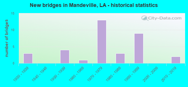
- New bridges - historical statistics
- 31930-1939
- 41950-1959
- 11960-1969
- 131970-1979
- 31980-1989
- 91990-1999
- 22010-2019


- Bridge Condition - Deck
- 3.1%Very good
- 62.5%Good
- 34.4%Satisfactory

- Bridge Condition - Superstructure
- 21.9%Very good
- 43.8%Good
- 34.4%Satisfactory

- Bridge Condition - Substructure
- 25.0%Very good
- 56.3%Good
- 18.8%Satisfactory

- Bridge Condition - Channel
- 24.0%Very good
- 64.0%Good
- 8.0%Satisfactory
- 4.0%Fair

- Bridge Condition - Culverts
- 66.7%Good
- 33.3%Satisfactory
Find on map >> Show street view
Structure Number: 625200000620266, Location: 0.7 MILES NORTH OF FAIRWA (Lat: 30.422019, Lng: -90.096631), Route carried "on" structure: County highway , Year Built: 1936, Status: Open, Structure Length: 1.16m (3.81ft), Average Daily Traffic: 100 (year 2011), Truck Traffic: 1%, Average Future Daily Traffic: 76 (year 2036), Design Load: HS 15, Features Intersected: DRAIN, Facility Carried by Structure: Belle Terre Blvd.
Minimum Vertical Clearance: 30+ m (98+ ft), Kilometerpoint: 0.000, Lanes on structure: 2, Owner: County Highway Agency, Approaching Roadway Width: 5.8m (19.0ft), Material/Design: Steel, Design/Construction: Arch - Deck, Number Of Spans In Main Unit: 3, Length of Maximum Span: 3.4m (11.2ft), Curb-To-Curb Width: 5.7m (18.7ft), Out-to-Out Width: 7.0m (23.0ft)
Condition: Deck: Satisfactory, Superstructure: Satisfactory, Substructure: Good, Channel: Satisfactory, Operating Rating: 42.1 metric tons, Method Used To Determine Operating Rating: Load and Resistance Factor Rating (LRFR) rating reported by rating factor(RF) method using HL-93 loadings, Inventory Rating: 32.4 metric tons, Method Used To Determine Inventory Rating: Load and Resistance Factor Rating (LRFR) rating reported by rating factor(RF) method using HL-93 loadings, Structural Evaluation: Equal to present minimum criteria, Deck Geometry: Meets minimum limits, Waterway Adequacy: Better than present minimum criteria, Approach Roadway Alignment: Equal to present minimum criteria, Designated Inspection Frequency: Every 24 months, Inspection Date: January 2022, Wearing Surface/Protective System: Wearing Surface: Bituminous
Find on map >> Show street view
Structure Number: 625200000620298, Location: .50 OF A MILE EAST OF LA (Lat: 30.384039, Lng: -90.079000), Route carried "on" structure: US 190, Year Built: 2013, Status: Open, Structure Length: 5.49m (18.01ft), Average Daily Traffic: 12,700 (year 2016), Truck Traffic: 6%, Average Future Daily Traffic: 19,304 (year 2036), Design Load: HS 20, Features Intersected: BAYOU
Minimum Vertical Clearance: 30+ m (98+ ft), Kilometerpoint: 32.414, Lanes on structure: 2, Base Highway Network: Yes (Inventory Route: 13-12-2, Subroute: 10), Owner: State Highway Agency, Approaching Roadway Width: 8.8m (28.9ft), Skew: 30 degrees, Material/Design: Concrete, Design/Construction: Slab, Number Of Spans In Main Unit: 9, Length of Maximum Span: 6.1m (20.0ft), Curb or Sidewalk Widths: Left: 1.8m (5.9ft), Right: 0.0m, Curb-To-Curb Width: 8.8m (28.9ft), Out-to-Out Width: 11.2m (36.7ft)
Condition: Deck: Very good, Superstructure: Very good, Substructure: Very good, Channel: Good, Operating Rating: 63.5 metric tons, Method Used To Determine Operating Rating: Load and Resistance Factor Rating (LRFR) rating reported by rating factor(RF) method using HL-93 loadings, Inventory Rating: 44.7 metric tons, Method Used To Determine Inventory Rating: Load and Resistance Factor Rating (LRFR) rating reported by rating factor(RF) method using HL-93 loadings, Structural Evaluation: Equal to present desirable criteria, Deck Geometry: High priority of corrective action, Waterway Adequacy: Equal to present desirable criteria, Approach Roadway Alignment: Better than present minimum criteria, Designated Inspection Frequency: Every 24 months, Inspection Date: September 2021, Deck Structure Type: Concrete Cast-file-Place, Wearing Surface/Protective System: Wearing Surface: Monolithic Concrete
Find on map >> Show street view
Structure Number: 625200000620299, Location: .50 OF A MILE EAST OF LA (Lat: 30.384550, Lng: -90.079100), Route carried "on" structure: US 190, Year Built: 2014, Status: Open, Structure Length: 5.49m (18.01ft), Average Daily Traffic: 12,700 (year 2016), Truck Traffic: 6%, Average Future Daily Traffic: 19,304 (year 2036), Design Load: HS 20, Features Intersected: BAYOU CHINCHUBA
Minimum Vertical Clearance: 30+ m (98+ ft), Kilometerpoint: 1.720, Lanes on structure: 2, Base Highway Network: Yes (Inventory Route: 13-12-1, Subroute: 10), Owner: State Highway Agency, Approaching Roadway Width: 8.8m (28.9ft), Skew: 30 degrees, Material/Design: Concrete, Design/Construction: Slab, Number Of Spans In Main Unit: 9, Length of Maximum Span: 6.1m (20.0ft), Curb or Sidewalk Widths: Left: 0.0m, Right: 1.8m (5.9ft), Curb-To-Curb Width: 8.8m (28.9ft), Out-to-Out Width: 11.2m (36.7ft)
Condition: Deck: Good, Superstructure: Good, Substructure: Good, Channel: Good, Operating Rating: 63.5 metric tons, Method Used To Determine Operating Rating: Load and Resistance Factor Rating (LRFR) rating reported by rating factor(RF) method using HL-93 loadings, Inventory Rating: 44.7 metric tons, Method Used To Determine Inventory Rating: Load and Resistance Factor Rating (LRFR) rating reported by rating factor(RF) method using HL-93 loadings, Structural Evaluation: Better than present minimum criteria, Deck Geometry: High priority of corrective action, Waterway Adequacy: Equal to present desirable criteria, Approach Roadway Alignment: Equal to present desirable criteria, Designated Inspection Frequency: Every 24 months, Inspection Date: September 2021, Deck Structure Type: Concrete Cast-file-Place, Wearing Surface/Protective System: Wearing Surface: Monolithic Concrete
Find on map >> Show street view
Structure Number: 625200000620346, Location: 1.70 MI EAST OF US 90 (Lat: 30.431269, Lng: -90.073281), Route carried "on" structure: County highway , Year Built: 1999, Status: Open, Structure Length: 0.79m (2.59ft), Average Daily Traffic: 200 (year 2016), Average Future Daily Traffic: 220 (year 2036), Design Load: HS 20, Features Intersected: DRAIN, Facility Carried by Structure: GOLDEN MEADOW DR.
Minimum Vertical Clearance: 30+ m (98+ ft), Kilometerpoint: 0.505, Lanes on structure: 2, Owner: County Highway Agency, Approaching Roadway Width: 6.1m (20.0ft), Material/Design: Concrete, Design/Construction: Culvert, Number Of Spans In Main Unit: 3, Length of Maximum Span: 2.1m (6.9ft), Out-to-Out Width: 19.5m (64.0ft)
Condition: Channel: Good, Culverts: Good, Operating Rating: 32.7 metric tons, Method Used To Determine Operating Rating: Load and Resistance Factor Rating (LRFR) rating reported by rating factor(RF) method using HL-93 loadings, Inventory Rating: 25.3 metric tons, Method Used To Determine Inventory Rating: Load and Resistance Factor Rating (LRFR) rating reported by rating factor(RF) method using HL-93 loadings, Structural Evaluation: Equal to present minimum criteria, Waterway Adequacy: Equal to present desirable criteria, Approach Roadway Alignment: Equal to present minimum criteria, Designated Inspection Frequency: Every 24 months, Inspection Date: Febuary 2021
Find on map >> Show street view
Structure Number: 62520000062522, Location: 0.65 Mi E. of La 59 (Lat: 30.365389, Lng: -90.047600), Route carried "on" structure: County highway , Year Built: 1998, Status: Open, Structure Length: 1.37m (4.49ft), Average Daily Traffic: 400 (year 2020), Average Future Daily Traffic: 440 (year 2040), Design Load: HL 93, Features Intersected: Little Bayou Castine, Facility Carried by Structure: Dupard St.
Minimum Vertical Clearance: 0.00m, Kilometerpoint: 2.084, Lanes on structure: 2, Owner: County Highway Agency, Approaching Roadway Width: 6.7m (22.0ft), Material/Design: Steel, Design/Construction: Culvert, Number Of Spans In Main Unit: 4, Length of Maximum Span: 2.4m (7.9ft), Curb-To-Curb Width: 6.7m (22.0ft), Out-to-Out Width: 13.7m (44.9ft)
Condition: Channel: Good, Culverts: Good, Operating Rating: 31.8 metric tons, Method Used To Determine Operating Rating: Load and Resistance Factor Rating (LRFR) rating reported by rating factor(RF) method using HL-93 loadings, Inventory Rating: 24.6 metric tons, Method Used To Determine Inventory Rating: Load and Resistance Factor Rating (LRFR) rating reported by rating factor(RF) method using HL-93 loadings, Structural Evaluation: Equal to present minimum criteria, Deck Geometry: Meets minimum limits, Waterway Adequacy: Better than present minimum criteria, Approach Roadway Alignment: Better than present minimum criteria, Designated Inspection Frequency: Every 24 months, Inspection Date: December 2021
Find on map >> Show street view
Structure Number: 625200131103671, Location: US 190 (Lat: 30.424369, Lng: -90.085000), Route carried "on" structure: US 190, Year Built: 1976, Status: Open, Structure Length: 6.10m (20.01ft), Average Daily Traffic: 25,200 (year 2016), Truck Traffic: 14%, Average Future Daily Traffic: 22,982 (year 2036), Design Load: HS 20, Features Intersected: PONCHITOLAWA CR
Minimum Vertical Clearance: 30+ m (98+ ft), Kilometerpoint: 5.546, Lanes on structure: 3, Base Highway Network: Yes (Inventory Route: 13-11-1, Subroute: 10), Owner: State Highway Agency, Approaching Roadway Width: 15.9m (52.2ft), Skew: 10 degrees, Material/Design: Concrete, Design/Construction: Slab, Number Of Spans In Main Unit: 8, Length of Maximum Span: 7.6m (24.9ft), Curb-To-Curb Width: 15.9m (52.2ft), Out-to-Out Width: 16.7m (54.8ft)
Condition: Deck: Satisfactory, Superstructure: Satisfactory, Substructure: Good, Channel: Good, Operating Rating: 68.9 metric tons, Method Used To Determine Operating Rating: Load Factor (LF), Inventory Rating: 41.7 metric tons, Method Used To Determine Inventory Rating: Load Factor (LF), Structural Evaluation: Equal to present minimum criteria, Deck Geometry: Somewhat better than minimum adequacy, Waterway Adequacy: Better than present minimum criteria, Approach Roadway Alignment: Equal to present desirable criteria, Designated Inspection Frequency: Every 24 months, Underwater Inspection Frequency: Every 60 months, Inspection Date: September 2021, Underwater Inspection Date: August 2019, Deck Structure Type: Concrete Cast-file-Place
Find on map >> Show street view
Structure Number: 625200131103672, Location: US 190 (Lat: 30.423911, Lng: -90.084600), Route carried "on" structure: US 190, Year Built: 1976, Status: Open, Structure Length: 6.10m (20.01ft), Average Daily Traffic: 25,200 (year 2016), Truck Traffic: 14%, Average Future Daily Traffic: 22,982 (year 2036), Design Load: HS 20, Features Intersected: PONCHITOLAWA CREEK
Minimum Vertical Clearance: 30+ m (98+ ft), Kilometerpoint: 4.192, Lanes on structure: 2, Base Highway Network: Yes (Inventory Route: 13-11-2, Subroute: 10), Owner: State Highway Agency, Approaching Roadway Width: 12.2m (40.0ft), Skew: 11 degrees, Material/Design: Concrete, Design/Construction: Slab, Number Of Spans In Main Unit: 8, Length of Maximum Span: 7.6m (24.9ft), Curb or Sidewalk Widths: Left: 3.0m (9.8ft), Right: 0.0m, Curb-To-Curb Width: 12.2m (40.0ft), Out-to-Out Width: 15.5m (50.9ft)
Condition: Deck: Satisfactory, Superstructure: Satisfactory, Substructure: Good, Channel: Good, Operating Rating: 64.4 metric tons, Method Used To Determine Operating Rating: Load Factor (LF), Inventory Rating: 38.1 metric tons, Method Used To Determine Inventory Rating: Load Factor (LF), Structural Evaluation: Equal to present minimum criteria, Deck Geometry: Better than present minimum criteria, Waterway Adequacy: Better than present minimum criteria, Approach Roadway Alignment: Equal to present desirable criteria, Designated Inspection Frequency: Every 24 months, Underwater Inspection Frequency: Every 60 months, Inspection Date: September 2021, Underwater Inspection Date: August 2019, Deck Structure Type: Concrete Cast-file-Place
Find on map >> Show street view
Structure Number: 625200131103673, Location: US 190 (Lat: 30.424319, Lng: -90.085300), Route carried "on" structure: ServiceUS 190, Year Built: 1976, Status: Open, Structure Length: 5.79m (19.00ft), Average Daily Traffic: 5,040 (year 2016), Truck Traffic: 9%, Average Future Daily Traffic: 3,830 (year 2036), Design Load: HS 20, Features Intersected: PONCHITOLAWA CR
Minimum Vertical Clearance: 30+ m (98+ ft), Kilometerpoint: 0.122, Lanes on structure: 2, Owner: State Highway Agency, Approaching Roadway Width: 10.4m (34.1ft), Material/Design: Concrete, Design/Construction: Slab, Number Of Spans In Main Unit: 8, Length of Maximum Span: 7.6m (24.9ft), Curb-To-Curb Width: 8.2m (26.9ft), Out-to-Out Width: 9.2m (30.2ft)
Condition: Deck: Good, Superstructure: Good, Substructure: Good, Channel: Good, Operating Rating: 58.0 metric tons, Method Used To Determine Operating Rating: Load Factor (LF), Inventory Rating: 34.5 metric tons, Method Used To Determine Inventory Rating: Load Factor (LF), Structural Evaluation: Better than present minimum criteria, Deck Geometry: High priority of replacement, Waterway Adequacy: Better than present minimum criteria, Approach Roadway Alignment: Equal to present desirable criteria, Designated Inspection Frequency: Every 24 months, Underwater Inspection Frequency: Every 60 months, Inspection Date: September 2021, Underwater Inspection Date: August 2019, Deck Structure Type: Concrete Cast-file-Place
Find on map >> Show street view
Structure Number: 625200131103674, Location: US 190 (Lat: 30.424161, Lng: -90.084100), Route carried "on" structure: ServiceUS 190, Year Built: 1976, Status: Open, Structure Length: 6.10m (20.01ft), Average Daily Traffic: 5,040 (year 2016), Truck Traffic: 9%, Average Future Daily Traffic: 3,830 (year 2036), Design Load: HS 20, Features Intersected: PONCHITOLAWA CR
Minimum Vertical Clearance: 30+ m (98+ ft), Kilometerpoint: 5.137, Lanes on structure: 2, Owner: State Highway Agency, Approaching Roadway Width: 10.4m (34.1ft), Skew: 2 degrees, Material/Design: Concrete, Design/Construction: Slab, Number Of Spans In Main Unit: 8, Length of Maximum Span: 7.6m (24.9ft), Curb-To-Curb Width: 8.2m (26.9ft), Out-to-Out Width: 9.2m (30.2ft)
Condition: Deck: Good, Superstructure: Good, Substructure: Good, Channel: Good, Operating Rating: 64.4 metric tons, Method Used To Determine Operating Rating: Load Factor (LF), Inventory Rating: 38.1 metric tons, Method Used To Determine Inventory Rating: Load Factor (LF), Structural Evaluation: Better than present minimum criteria, Deck Geometry: High priority of corrective action, Waterway Adequacy: Better than present minimum criteria, Approach Roadway Alignment: Equal to present desirable criteria, Designated Inspection Frequency: Every 24 months, Underwater Inspection Frequency: Every 60 months, Inspection Date: September 2021, Underwater Inspection Date: August 2019, Deck Structure Type: Concrete Cast-file-Place
Find on map >> Show street view
Structure Number: 625200131103678, Location: US 190 (Lat: 30.423969, Lng: -90.084400), Route carried "on" structure: Ramp US 190, Year Built: 1976, Status: Open, Structure Length: 6.10m (20.01ft), Average Daily Traffic: 5,040 (year 2016), Truck Traffic: 14%, Average Future Daily Traffic: 3,830 (year 2036), Design Load: HS 20, Features Intersected: PONCHITOLAWA CR
Minimum Vertical Clearance: 30+ m (98+ ft), Kilometerpoint: 0.122, Lanes on structure: 1, Owner: State Highway Agency, Approaching Roadway Width: 7.6m (24.9ft), Skew: 1 degrees, Material/Design: Concrete, Design/Construction: Slab, Number Of Spans In Main Unit: 8, Length of Maximum Span: 7.6m (24.9ft), Curb-To-Curb Width: 7.6m (24.9ft), Out-to-Out Width: 8.6m (28.2ft)
Condition: Deck: Good, Superstructure: Good, Substructure: Good, Channel: Good, Operating Rating: 64.4 metric tons, Method Used To Determine Operating Rating: Load Factor (LF), Inventory Rating: 38.1 metric tons, Method Used To Determine Inventory Rating: Load Factor (LF), Structural Evaluation: Better than present minimum criteria, Deck Geometry: Better than present minimum criteria, Waterway Adequacy: Better than present minimum criteria, Approach Roadway Alignment: Equal to present desirable criteria, Designated Inspection Frequency: Every 24 months, Underwater Inspection Frequency: Every 60 months, Inspection Date: September 2021, Underwater Inspection Date: August 2019, Deck Structure Type: Concrete Cast-file-Place
Find on map >> Show street view
Structure Number: 625200131104621, Location: US 190 LOG MI 4.62 (Lat: 30.410050, Lng: -90.084600), Route carried "on" structure: US 190, Year Built: 1987, Status: Open, Structure Length: 6.86m (22.51ft), Average Daily Traffic: 25,200 (year 2016), Truck Traffic: 14%, Average Future Daily Traffic: 22,982 (year 2036), Design Load: HS 20, Features Intersected: FAIRWAY DRIVE OVERPASS
Minimum Vertical Clearance: 30+ m (98+ ft), Kilometerpoint: 2.638, Lanes on structure: 2, Lanes under structure: 6, Base Highway Network: Yes (Inventory Route: 13-11-2, Subroute: 10), Owner: State Highway Agency, Approaching Roadway Width: 12.8m (42.0ft), Skew: 10 degrees, Material/Design: Prestressed concrete continuous, Design/Construction: Stringer/Multi-beam, Number Of Spans In Main Unit: 2, Length of Maximum Span: 34.4m (112.9ft), Curb-To-Curb Width: 12.2m (40.0ft), Out-to-Out Width: 13.0m (42.7ft)
Condition: Deck: Good, Superstructure: Good, Substructure: Very good, Operating Rating: 81.6 metric tons, Method Used To Determine Operating Rating: Load Factor (LF), Inventory Rating: 39.0 metric tons, Method Used To Determine Inventory Rating: Load Factor (LF), Structural Evaluation: Better than present minimum criteria, Deck Geometry: Better than present minimum criteria, Underclear: Equal to present minimum criteria, Approach Roadway Alignment: Equal to present desirable criteria, Designated Inspection Frequency: Every 24 months, Inspection Date: September 2021, Deck Structure Type: Concrete Cast-file-Place
Find on map >> Show street view
Structure Number: 625200131104622, Location: US 190 LOG MI 4.62 (Lat: 30.410650, Lng: -90.084800), Route carried "on" structure: US 190, Year Built: 1987, Status: Open, Structure Length: 6.92m (22.70ft), Average Daily Traffic: 25,200 (year 2016), Truck Traffic: 14%, Average Future Daily Traffic: 22,982 (year 2036), Design Load: HS 20, Features Intersected: FAIRWAY DRIVE OVERPASS
Minimum Vertical Clearance: 30+ m (98+ ft), Kilometerpoint: 7.086, Lanes on structure: 2, Lanes under structure: 6, Base Highway Network: Yes (Inventory Route: 13-11-1, Subroute: 10), Owner: State Highway Agency, Approaching Roadway Width: 12.2m (40.0ft), Skew: 10 degrees, Material/Design: Prestressed concrete continuous, Design/Construction: Stringer/Multi-beam, Number Of Spans In Main Unit: 2, Length of Maximum Span: 34.4m (112.9ft), Curb-To-Curb Width: 12.2m (40.0ft), Out-to-Out Width: 13.0m (42.7ft)
Condition: Deck: Good, Superstructure: Good, Substructure: Good, Operating Rating: 81.6 metric tons, Method Used To Determine Operating Rating: Load Factor (LF), Inventory Rating: 39.0 metric tons, Method Used To Determine Inventory Rating: Load Factor (LF), Structural Evaluation: Better than present minimum criteria, Deck Geometry: Better than present minimum criteria, Underclear: Equal to present minimum criteria, Approach Roadway Alignment: Equal to present desirable criteria, Designated Inspection Frequency: Every 24 months, Inspection Date: September 2021, Deck Structure Type: Concrete Cast-file-Place
Find on map >> Show street view
Structure Number: 625200131105821, Location: 0.1 M E OF LA 22 (Lat: 30.394231, Lng: -90.088700), Route carried "on" structure: US 190, Year Built: 1981, Status: Open, Structure Length: 8.35m (27.40ft), Average Daily Traffic: 58,000 (year 2016), Truck Traffic: 14%, Average Future Daily Traffic: 43,472 (year 2036), Design Load: HS 20, Features Intersected: LA 22
Minimum Vertical Clearance: 30+ m (98+ ft), Kilometerpoint: 8.946, Lanes on structure: 4, Lanes under structure: 6, Base Highway Network: Yes (Inventory Route: 13-11-1, Subroute: 10), Owner: State Highway Agency, Approaching Roadway Width: 31.1m (102.0ft), Skew: 30 degrees, Material/Design: Prestressed concrete, Design/Construction: Stringer/Multi-beam, Number Of Spans In Main Unit: 4, Length of Maximum Span: 23.2m (76.1ft), Curb-To-Curb Width: 21.3m (69.9ft), Out-to-Out Width: 28.7m (94.2ft)
Condition: Deck: Good, Superstructure: Very good, Substructure: Very good, Operating Rating: 67.1 metric tons, Method Used To Determine Operating Rating: Load Factor (LF), Inventory Rating: 34.5 metric tons, Method Used To Determine Inventory Rating: Load Factor (LF), Structural Evaluation: Equal to present desirable criteria, Deck Geometry: Better than present minimum criteria, Underclear: Equal to present desirable criteria, Approach Roadway Alignment: Equal to present desirable criteria, Designated Inspection Frequency: Every 24 months, Inspection Date: September 2021, Deck Structure Type: Concrete Cast-file-Place
Find on map >> Show street view
Structure Number: 625200131203001, Location: 0.5 M E OF LA 59 (Lat: 30.359581, Lng: -90.053800), Route carried "on" structure: US 190, Year Built: 1932, Status: Open, Structure Length: 0.82m (2.69ft), Average Daily Traffic: 25,400 (year 2016), Truck Traffic: 6%, Average Future Daily Traffic: 19,304 (year 2036), Design Load: H 15, Features Intersected: CREEK
Minimum Vertical Clearance: 30+ m (98+ ft), Kilometerpoint: 5.699, Lanes on structure: 2, Base Highway Network: Yes (Inventory Route: 13-12-1, Subroute: 10), Owner: State Highway Agency, Approaching Roadway Width: 13.4m (44.0ft), Material/Design: Concrete, Design/Construction: Culvert, Number Of Spans In Main Unit: 3, Length of Maximum Span: 2.4m (7.9ft), Curb-To-Curb Width: 7.3m (24.0ft), Out-to-Out Width: 16.5m (54.1ft)
Condition: Channel: Good, Culverts: Satisfactory, Operating Rating: 42.1 metric tons, Method Used To Determine Operating Rating: Load and Resistance Factor Rating (LRFR) rating reported by rating factor(RF) method using HL-93 loadings, Inventory Rating: 32.4 metric tons, Method Used To Determine Inventory Rating: Load and Resistance Factor Rating (LRFR) rating reported by rating factor(RF) method using HL-93 loadings, Structural Evaluation: Equal to present minimum criteria, Deck Geometry: High priority of replacement, Waterway Adequacy: Better than present minimum criteria, Approach Roadway Alignment: Equal to present desirable criteria, Designated Inspection Frequency: Every 24 months, Inspection Date: September 2021, Deck Structure Type: Concrete Cast-file-Place
Find on map >> Show street view
Structure Number: 625200131204111, Location: US0190 (Lat: 30.351519, Lng: -90.037800), Route carried "on" structure: US 190, Year Built: 1932, Status: Open, Structure Length: 4.60m (15.09ft), Average Daily Traffic: 9,200 (year 2016), Truck Traffic: 6%, Average Future Daily Traffic: 6,992 (year 2036), Design Load: H 15, Features Intersected: BAYOU CASTINE
Minimum Vertical Clearance: 30+ m (98+ ft), Kilometerpoint: 7.480, Lanes on structure: 2, Base Highway Network: Yes (Inventory Route: 13-12-1, Subroute: 10), Owner: State Highway Agency, Approaching Roadway Width: 13.4m (44.0ft), Material/Design: Concrete, Design/Construction: Tee Beam, Number Of Spans In Main Unit: 5, Length of Maximum Span: 9.1m (29.9ft), Curb-To-Curb Width: 7.3m (24.0ft), Out-to-Out Width: 8.3m (27.2ft)
Condition: Deck: Satisfactory, Superstructure: Satisfactory, Substructure: Satisfactory, Channel: Good, Operating Rating: 49.0 metric tons, Method Used To Determine Operating Rating: Load Factor (LF), Inventory Rating: 29.0 metric tons, Method Used To Determine Inventory Rating: Load Factor (LF), Structural Evaluation: Equal to present minimum criteria, Deck Geometry: High priority of replacement, Waterway Adequacy: Better than present minimum criteria, Approach Roadway Alignment: Equal to present desirable criteria, Length Of Structure Improvement: 5.52m (18.11ft), Designated Inspection Frequency: Every 24 months, Inspection Date: September 2021, Bridge Improvement Cost: $470,000, Total Project Cost: $705,000 ( Estimate for 2016), Deck Structure Type: Concrete Cast-file-Place, Wearing Surface/Protective System: Wearing Surface: Bituminous
Find on map >> Show street view
Structure Number: 625204540410861, Location: 0.7 M E OF US 190 (Lat: 30.426031, Lng: -90.072200), Route carried "on" structure: Interstate 12, Year Built: 1976, Status: Open, Structure Length: 5.33m (17.49ft), Average Daily Traffic: 33,650 (year 2016), Truck Traffic: 26%, Average Future Daily Traffic: 29,868 (year 2036), Design Load: HS 20, Features Intersected: PONCHATOLAWA CREEK
Minimum Vertical Clearance: 30+ m (98+ ft), Kilometerpoint: 17.674, Lanes on structure: 2, Base Highway Network: Yes (Inventory Route: 454-04-1, Subroute: 10), Owner: State Highway Agency, Approaching Roadway Width: 11.6m (38.1ft), Skew: 3 degrees, Material/Design: Concrete, Design/Construction: Slab, Number Of Spans In Main Unit: 7, Length of Maximum Span: 7.6m (24.9ft), Curb-To-Curb Width: 12.2m (40.0ft), Out-to-Out Width: 13.0m (42.7ft)
Condition: Deck: Satisfactory, Superstructure: Satisfactory, Substructure: Good, Channel: Good, Operating Rating: 59.3 metric tons, Method Used To Determine Operating Rating: Load and Resistance Factor Rating (LRFR) rating reported by rating factor(RF) method using HL-93 loadings, Inventory Rating: 35.3 metric tons, Method Used To Determine Inventory Rating: Load and Resistance Factor Rating (LRFR) rating reported by rating factor(RF) method using HL-93 loadings, Structural Evaluation: Equal to present minimum criteria, Deck Geometry: Better than present minimum criteria, Waterway Adequacy: Better than present minimum criteria, Approach Roadway Alignment: Equal to present desirable criteria, Designated Inspection Frequency: Every 24 months, Inspection Date: August 2021, Deck Structure Type: Concrete Cast-file-Place
Find on map >> Show street view
Structure Number: 625204540410862, Location: 0.7 M E OF US 190 (Lat: 30.426111, Lng: -90.071400), Route carried "on" structure: Interstate 12, Year Built: 1976, Status: Open, Structure Length: 5.33m (17.49ft), Average Daily Traffic: 33,650 (year 2016), Truck Traffic: 26%, Average Future Daily Traffic: 29,868 (year 2036), Design Load: HS 20, Features Intersected: PONCHATOLAWA CREEK
Minimum Vertical Clearance: 30+ m (98+ ft), Kilometerpoint: 36.173, Lanes on structure: 2, Base Highway Network: Yes (Inventory Route: 454-04-2, Subroute: 10), Owner: State Highway Agency, Approaching Roadway Width: 11.6m (38.1ft), Skew: 3 degrees, Material/Design: Concrete, Design/Construction: Slab, Number Of Spans In Main Unit: 7, Length of Maximum Span: 7.6m (24.9ft), Curb-To-Curb Width: 12.2m (40.0ft), Out-to-Out Width: 13.0m (42.7ft)
Condition: Deck: Satisfactory, Superstructure: Satisfactory, Substructure: Good, Channel: Very good, Operating Rating: 32.4 metric tons, Method Used To Determine Operating Rating: Load and Resistance Factor Rating (LRFR) rating reported by rating factor(RF) method using HL-93 loadings, Inventory Rating: 24.9 metric tons, Method Used To Determine Inventory Rating: Load and Resistance Factor Rating (LRFR) rating reported by rating factor(RF) method using HL-93 loadings, Structural Evaluation: Equal to present minimum criteria, Deck Geometry: Better than present minimum criteria, Waterway Adequacy: Better than present minimum criteria, Approach Roadway Alignment: Equal to present desirable criteria, Designated Inspection Frequency: Every 24 months, Inspection Date: August 2021, Deck Structure Type: Concrete Cast-file-Place
Find on map >> Show street view
Structure Number: 625204540412601, Location: 0.1 M W OF LA 59 (Lat: 30.416000, Lng: -90.045700), Route carried "on" structure: Interstate 12, Year Built: 1976, Status: Open, Structure Length: 12.22m (40.09ft), Average Daily Traffic: 33,650 (year 2016), Truck Traffic: 26%, Average Future Daily Traffic: 29,868 (year 2036), Design Load: HS 20, Features Intersected: CANAL & BIKE TR
Minimum Vertical Clearance: 7.06m (23.16ft), Kilometerpoint: 20.471, Lanes on structure: 2, Base Highway Network: Yes (Inventory Route: 454-04-1, Subroute: 10), Owner: State Highway Agency, Approaching Roadway Width: 11.6m (38.1ft), Skew: 12 degrees, Material/Design: Prestressed concrete, Design/Construction: Stringer/Multi-beam, Number Of Spans In Main Unit: 6, Length of Maximum Span: 21.3m (69.9ft), Curb-To-Curb Width: 12.2m (40.0ft), Out-to-Out Width: 13.0m (42.7ft)
Condition: Deck: Good, Superstructure: Good, Substructure: Good, Channel: Good, Operating Rating: 51.2 metric tons, Method Used To Determine Operating Rating: Load and Resistance Factor Rating (LRFR) rating reported by rating factor(RF) method using HL-93 loadings, Inventory Rating: 28.8 metric tons, Method Used To Determine Inventory Rating: Load and Resistance Factor Rating (LRFR) rating reported by rating factor(RF) method using HL-93 loadings, Structural Evaluation: Better than present minimum criteria, Deck Geometry: Better than present minimum criteria, Underclear: Superior to present desirable criteria, Waterway Adequacy: Equal to present desirable criteria, Approach Roadway Alignment: Equal to present desirable criteria, Designated Inspection Frequency: Every 24 months, Inspection Date: August 2021, Deck Structure Type: Concrete Cast-file-Place
Find on map >> Show street view
Structure Number: 625204540412602, Location: 0.1 M W OF LA 59 (Lat: 30.415611, Lng: -90.044500), Route carried "on" structure: Interstate 12, Year Built: 1976, Status: Open, Structure Length: 12.98m (42.59ft), Average Daily Traffic: 33,650 (year 2016), Truck Traffic: 26%, Average Future Daily Traffic: 29,868 (year 2036), Design Load: HS 20, Features Intersected: CANAL&BIKE TRAIL
Minimum Vertical Clearance: 7.06m (23.16ft), Kilometerpoint: 33.313, Lanes on structure: 3, Base Highway Network: Yes (Inventory Route: 454-04-2, Subroute: 10), Owner: State Highway Agency, Approaching Roadway Width: 15.2m (49.9ft), Skew: 12 degrees, Material/Design: Prestressed concrete, Design/Construction: Stringer/Multi-beam, Number Of Spans In Main Unit: 7, Length of Maximum Span: 21.3m (69.9ft), Curb-To-Curb Width: 15.7m (51.5ft), Out-to-Out Width: 16.7m (54.8ft)
Condition: Deck: Good, Superstructure: Very good, Substructure: Very good, Channel: Very good, Operating Rating: 59.3 metric tons, Method Used To Determine Operating Rating: Load and Resistance Factor Rating (LRFR) rating reported by rating factor(RF) method using HL-93 loadings, Inventory Rating: 35.3 metric tons, Method Used To Determine Inventory Rating: Load and Resistance Factor Rating (LRFR) rating reported by rating factor(RF) method using HL-93 loadings, Structural Evaluation: Equal to present desirable criteria, Deck Geometry: Somewhat better than minimum adequacy, Underclear: Superior to present desirable criteria, Waterway Adequacy: Equal to present desirable criteria, Approach Roadway Alignment: Equal to present desirable criteria, Designated Inspection Frequency: Every 24 months, Inspection Date: August 2021, Deck Structure Type: Concrete Cast-file-Place, Wearing Surface/Protective System: Wearing Surface: Bituminous
Find on map >> Show street view
Structure Number: 625204540412931, Location: 2.7 M E OF US 190 (Lat: 30.413500, Lng: -90.041300), Route carried "on" structure: Interstate 12, Year Built: 1976, Status: Open, Structure Length: 7.53m (24.70ft), Average Daily Traffic: 22,100 (year 2016), Truck Traffic: 26%, Average Future Daily Traffic: 20,109 (year 2036), Design Load: HS 20, Features Intersected: LA 59
Minimum Vertical Clearance: 30+ m (98+ ft), Kilometerpoint: 20.983, Lanes on structure: 2, Lanes under structure: 2, Base Highway Network: Yes (Inventory Route: 454-04-1, Subroute: 10), Owner: State Highway Agency, Approaching Roadway Width: 12.2m (40.0ft), Skew: 13 degrees, Material/Design: Steel, Design/Construction: Stringer/Multi-beam, Number Of Spans In Main Unit: 3, Length of Maximum Span: 37.5m (123.0ft), Curb-To-Curb Width: 12.2m (40.0ft), Out-to-Out Width: 13.0m (42.7ft)
Condition: Deck: Good, Superstructure: Good, Substructure: Good, Operating Rating: 51.2 metric tons, Method Used To Determine Operating Rating: Load and Resistance Factor Rating (LRFR) rating reported by rating factor(RF) method using HL-93 loadings, Inventory Rating: 28.8 metric tons, Method Used To Determine Inventory Rating: Load and Resistance Factor Rating (LRFR) rating reported by rating factor(RF) method using HL-93 loadings, Structural Evaluation: Better than present minimum criteria, Deck Geometry: Better than present minimum criteria, Underclear: Equal to present minimum criteria, Approach Roadway Alignment: Equal to present desirable criteria, Designated Inspection Frequency: Every 24 months, Inspection Date: August 2021, Deck Structure Type: Concrete Cast-file-Place
Find on map >> Show street view
Structure Number: 625204540412932, Location: 2.7 M E OF US 190 (Lat: 30.413400, Lng: -90.040500), Route carried "on" structure: Interstate 12, Year Built: 1976, Status: Open, Structure Length: 7.53m (24.70ft), Average Daily Traffic: 22,100 (year 2016), Truck Traffic: 26%, Average Future Daily Traffic: 20,109 (year 2036), Design Load: HS 20, Features Intersected: LA 59
Minimum Vertical Clearance: 30+ m (98+ ft), Kilometerpoint: 32.847, Lanes on structure: 2, Lanes under structure: 2, Base Highway Network: Yes (Inventory Route: 454-04-2, Subroute: 10), Owner: State Highway Agency, Approaching Roadway Width: 12.2m (40.0ft), Skew: 13 degrees, Material/Design: Steel, Design/Construction: Stringer/Multi-beam, Number Of Spans In Main Unit: 3, Length of Maximum Span: 37.5m (123.0ft), Curb-To-Curb Width: 12.2m (40.0ft), Out-to-Out Width: 13.0m (42.7ft)
Condition: Deck: Good, Superstructure: Good, Substructure: Good, Operating Rating: 41.5 metric tons, Method Used To Determine Operating Rating: Load and Resistance Factor Rating (LRFR) rating reported by rating factor(RF) method using HL-93 loadings, Inventory Rating: 32.1 metric tons, Method Used To Determine Inventory Rating: Load and Resistance Factor Rating (LRFR) rating reported by rating factor(RF) method using HL-93 loadings, Structural Evaluation: Better than present minimum criteria, Deck Geometry: Better than present minimum criteria, Underclear: Equal to present minimum criteria, Approach Roadway Alignment: Equal to present desirable criteria, Designated Inspection Frequency: Every 24 months, Inspection Date: August 2021, Deck Structure Type: Concrete Cast-file-Place
Find on map >> Show street view
Structure Number: 625230209900371, Location: 1.0 M SW of US 190 (Lat: 30.349561, Lng: -90.062189), Route carried "on" structure: County highway , Year Built: 1996, Status: Open, Structure Length: 1.16m (3.81ft), Average Daily Traffic: 1,300 (year 2016), Average Future Daily Traffic: 988 (year 2036), Design Load: HS 20, Features Intersected: LITTLE BAYOU BRIDGE, Facility Carried by Structure: Lakeshore Dr
Minimum Vertical Clearance: 30+ m (98+ ft), Kilometerpoint: 0.000, Lanes on structure: 2, Base Highway Network: Yes, Owner: City or Municipal Highway Agency, Approaching Roadway Width: 8.8m (28.9ft), Material/Design: Concrete, Design/Construction: Slab, Number Of Spans In Main Unit: 2, Length of Maximum Span: 5.8m (19.0ft), Curb-To-Curb Width: 9.8m (32.2ft), Out-to-Out Width: 10.5m (34.4ft)
Condition: Deck: Satisfactory, Superstructure: Satisfactory, Substructure: Satisfactory, Channel: Good, Operating Rating: 46.3 metric tons, Method Used To Determine Operating Rating: Load and Resistance Factor Rating (LRFR) rating reported by rating factor(RF) method using HL-93 loadings, Inventory Rating: 35.6 metric tons, Method Used To Determine Inventory Rating: Load and Resistance Factor Rating (LRFR) rating reported by rating factor(RF) method using HL-93 loadings, Structural Evaluation: Equal to present minimum criteria, Deck Geometry: Somewhat better than minimum adequacy, Waterway Adequacy: Equal to present minimum criteria, Approach Roadway Alignment: Equal to present minimum criteria, Designated Inspection Frequency: Every 24 months, Underwater Inspection Frequency: Every 60 months, Inspection Date: November 2020, Underwater Inspection Date: August 2019, Deck Structure Type: Other
Find on map >> Show street view
Structure Number: 625230212900371, Location: 0.1MI.EAST OF LAFITT (Lat: 30.354431, Lng: -90.061231), Route carried "on" structure: County highway , Year Built: 1970, Status: Posted for load, Structure Length: 1.74m (5.71ft), Design Load: HS 20, Features Intersected: LITTLE BAYOU, Facility Carried by Structure: Madison St
Minimum Vertical Clearance: 30+ m (98+ ft), Kilometerpoint: 0.000, Lanes on structure: 2, Owner: City or Municipal Highway Agency, Approaching Roadway Width: 5.5m (18.0ft), Material/Design: Concrete, Design/Construction: Slab, Number Of Spans In Main Unit: 3, Length of Maximum Span: 5.8m (19.0ft), Curb-To-Curb Width: 6.1m (20.0ft), Out-to-Out Width: 7.1m (23.3ft)
Condition: Deck: Satisfactory, Superstructure: Satisfactory, Substructure: Satisfactory, Channel: Good, Operating Rating: 15.9 metric tons, Method Used To Determine Operating Rating: Load and Resistance Factor Rating (LRFR) rating reported by rating factor(RF) method using HL-93 loadings, Inventory Rating: 12.3 metric tons, Method Used To Determine Inventory Rating: Load and Resistance Factor Rating (LRFR) rating reported by rating factor(RF) method using HL-93 loadings, Structural Evaluation: Meets minimum limits, Deck Geometry: Somewhat better than minimum adequacy, Waterway Adequacy: Equal to present minimum criteria, Approach Roadway Alignment: Better than present minimum criteria, Bridge Posting: Required (Relationship of Operating Rating to Maximum Legal Load: 30.0 - 39.9% below), Designated Inspection Frequency: Every 24 months, Other Special Inspection Frequency: Every 12 months, Inspection Date: November 2020, Other Special Inspection Date: November 2021, Deck Structure Type: Concrete Precast Panels
Find on map >> Show street view
Structure Number: 625230213900441, Location: 1.0 MILE WEST OF US 190 (Lat: 30.355761, Lng: -90.074511), Route carried "on" structure: County highway , Year Built: 1996, Status: Open, Structure Length: 1.16m (3.81ft), Average Daily Traffic: 1,300 (year 2016), Average Future Daily Traffic: 988 (year 2036), Design Load: HS 20, Features Intersected: BAYOU BRIDGE MANDEVILLE, Facility Carried by Structure: Lakeshore Dr
Minimum Vertical Clearance: 30+ m (98+ ft), Kilometerpoint: 0.000, Lanes on structure: 2, Base Highway Network: Yes, Owner: City or Municipal Highway Agency, Approaching Roadway Width: 9.1m (29.9ft), Material/Design: Concrete, Design/Construction: Slab, Number Of Spans In Main Unit: 2, Length of Maximum Span: 5.8m (19.0ft), Curb-To-Curb Width: 9.8m (32.2ft), Out-to-Out Width: 10.5m (34.4ft)
Condition: Deck: Satisfactory, Superstructure: Satisfactory, Substructure: Satisfactory, Channel: Good, Operating Rating: 43.7 metric tons, Method Used To Determine Operating Rating: Load and Resistance Factor Rating (LRFR) rating reported by rating factor(RF) method using HL-93 loadings, Inventory Rating: 33.7 metric tons, Method Used To Determine Inventory Rating: Load and Resistance Factor Rating (LRFR) rating reported by rating factor(RF) method using HL-93 loadings, Structural Evaluation: Equal to present minimum criteria, Deck Geometry: Somewhat better than minimum adequacy, Waterway Adequacy: Equal to present minimum criteria, Approach Roadway Alignment: Equal to present desirable criteria, Designated Inspection Frequency: Every 24 months, Inspection Date: November 2020, Deck Structure Type: Other
Find on map >> Show street view
Structure Number: 625230214900431, Location: 0.2MI.N.OF LAKE SHOR (Lat: 30.356861, Lng: -90.072461), Route carried "on" structure: County highway , Year Built: 1970, Status: Posted for load, Structure Length: 1.19m (3.90ft), Design Load: HS 20, Features Intersected: CREEK, Facility Carried by Structure: Coffee St
Minimum Vertical Clearance: 30+ m (98+ ft), Kilometerpoint: 0.000, Lanes on structure: 2, Owner: City or Municipal Highway Agency, Approaching Roadway Width: 5.5m (18.0ft), Material/Design: Concrete, Design/Construction: Slab, Number Of Spans In Main Unit: 2, Length of Maximum Span: 5.8m (19.0ft), Curb-To-Curb Width: 6.1m (20.0ft), Out-to-Out Width: 7.1m (23.3ft)
Condition: Deck: Satisfactory, Superstructure: Satisfactory, Substructure: Satisfactory, Channel: Fair, Operating Rating: 13.9 metric tons, Method Used To Determine Operating Rating: Load and Resistance Factor Rating (LRFR) rating reported by rating factor(RF) method using HL-93 loadings, Inventory Rating: 10.7 metric tons, Method Used To Determine Inventory Rating: Load and Resistance Factor Rating (LRFR) rating reported by rating factor(RF) method using HL-93 loadings, Structural Evaluation: High priority of corrective action, Deck Geometry: Somewhat better than minimum adequacy, Waterway Adequacy: Equal to present minimum criteria, Approach Roadway Alignment: Better than present minimum criteria, Bridge Posting: Required (Relationship of Operating Rating to Maximum Legal Load: 30.0 - 39.9% below), Designated Inspection Frequency: Every 24 months, Other Special Inspection Frequency: Every 12 months, Inspection Date: November 2020, Other Special Inspection Date: November 2021, Deck Structure Type: Concrete Precast Panels
Find on map >> Show street view
Structure Number: 625230222900561, Location: 0.30 MI N OF CAUSEWAY BR. (Lat: 30.369000, Lng: -90.093089), Route carried "on" structure: County highway , Year Built: 1993, Status: Open, Structure Length: 59.65m (195.70ft), Average Daily Traffic: 1,600 (year 1995), Average Future Daily Traffic: 1,216 (year 2036), Design Load: HS 20, Features Intersected: MONROE Str OVERPASS, Facility Carried by Structure: N. CAUSEWAY BLVD
Minimum Vertical Clearance: 5.36m (17.59ft), Kilometerpoint: 0.000, Lanes on structure: 2, Lanes under structure: 8, Base Highway Network: Yes, Toll: On toll road, Owner: Local Toll Authority, Approaching Roadway Width: 8.5m (27.9ft), Skew: 9 degrees, Material/Design: Concrete continuous, Design/Construction: Box Beam or Girders - Multiple, Number Of Spans In Main Unit: 13, Number Of Approach Spans: 18, Length of Maximum Span: 42.7m (140.1ft), Curb-To-Curb Width: 8.7m (28.5ft), Out-to-Out Width: 9.4m (30.8ft)
Condition: Deck: Good, Superstructure: Good, Substructure: Good, Operating Rating: 41.1 metric tons, Method Used To Determine Operating Rating: Load and Resistance Factor Rating (LRFR) rating reported by rating factor(RF) method using HL-93 loadings, Inventory Rating: 29.5 metric tons, Method Used To Determine Inventory Rating: Load and Resistance Factor Rating (LRFR) rating reported by rating factor(RF) method using HL-93 loadings, Structural Evaluation: Better than present minimum criteria, Deck Geometry: High priority of corrective action, Underclear: Meets minimum limits, Approach Roadway Alignment: Equal to present desirable criteria, Designated Inspection Frequency: Every 24 months, Inspection Date: November 2019, Deck Structure Type: Concrete Cast-file-Place
Find on map >> Show street view
Structure Number: 625230222900562, Location: 0.30 MI N OF CAUSEWAY BR. (Lat: 30.369019, Lng: -90.088119), Route carried "on" structure: County highway , Year Built: 1993, Status: Open, Structure Length: 64.74m (212.40ft), Average Daily Traffic: 1,600 (year 1995), Average Future Daily Traffic: 1,216 (year 2036), Design Load: HS 20, Features Intersected: MONROE Str OVERPASS, Facility Carried by Structure: N. CAUSEWAY APPR
Minimum Vertical Clearance: 5.36m (17.59ft), Kilometerpoint: 0.000, Lanes on structure: 2, Lanes under structure: 8, Toll: On toll road, Owner: Local Toll Authority, Approaching Roadway Width: 8.5m (27.9ft), Skew: 9 degrees, Material/Design: Concrete continuous, Design/Construction: Box Beam or Girders - Multiple, Number Of Spans In Main Unit: 32, Length of Maximum Span: 42.7m (140.1ft), Curb-To-Curb Width: 8.7m (28.5ft), Out-to-Out Width: 9.4m (30.8ft)
Condition: Deck: Good, Superstructure: Good, Substructure: Good, Operating Rating: 41.1 metric tons, Method Used To Determine Operating Rating: Load and Resistance Factor Rating (LRFR) rating reported by rating factor(RF) method using HL-93 loadings, Inventory Rating: 29.5 metric tons, Method Used To Determine Inventory Rating: Load and Resistance Factor Rating (LRFR) rating reported by rating factor(RF) method using HL-93 loadings, Structural Evaluation: Better than present minimum criteria, Deck Geometry: High priority of corrective action, Underclear: Meets minimum limits, Approach Roadway Alignment: Equal to present desirable criteria, Designated Inspection Frequency: Every 24 months, Inspection Date: November 2019, Deck Structure Type: Concrete Cast-file-Place
Find on map >> Show street view
Structure Number: 625230222900566, Location: 0.68 MI N OF CAUSEWAY BR. (Lat: 30.371831, Lng: -90.092800), Route carried "on" structure: Ramp County highway , Year Built: 1993, Status: Open, Structure Length: 4.57m (14.99ft), Average Daily Traffic: 500 (year 2016), Average Future Daily Traffic: 380 (year 2036), Design Load: HS 20, Features Intersected: N CAUSEWAY APPR S BOUND, Facility Carried by Structure: N. CAUSEWAY APPR
Minimum Vertical Clearance: 30+ m (98+ ft), Kilometerpoint: 0.000, Lanes on structure: 1, Toll: On toll road, Owner: Local Toll Authority, Approaching Roadway Width: 4.3m (14.1ft), Material/Design: Prestressed concrete, Design/Construction: Stringer/Multi-beam, Number Of Spans In Main Unit: 3, Length of Maximum Span: 15.2m (49.9ft), Curb-To-Curb Width: 4.4m (14.4ft), Out-to-Out Width: 5.2m (17.1ft)
Condition: Deck: Good, Superstructure: Good, Substructure: Good, Operating Rating: 56.7 metric tons, Method Used To Determine Operating Rating: Load and Resistance Factor Rating (LRFR) rating reported by rating factor(RF) method using HL-93 loadings, Inventory Rating: 43.7 metric tons, Method Used To Determine Inventory Rating: Load and Resistance Factor Rating (LRFR) rating reported by rating factor(RF) method using HL-93 loadings, Structural Evaluation: Better than present minimum criteria, Deck Geometry: High priority of replacement, Approach Roadway Alignment: Equal to present desirable criteria, Designated Inspection Frequency: Every 24 months, Inspection Date: November 2019, Deck Structure Type: Concrete Cast-file-Place
Find on map >> Show street view
Structure Number: 625230222900567, Location: 0.60 MI N OF CAUSEWAY BR. (Lat: 30.368050, Lng: -90.834700), Route carried "on" structure: Ramp County highway , Year Built: 1993, Status: Open, Structure Length: 31.91m (104.69ft), Average Daily Traffic: 1,600 (year 1995), Average Future Daily Traffic: 1,216 (year 2036), Design Load: HS 20, Features Intersected: N. CAUSEWAY APPR. S BOUN, Facility Carried by Structure: N. CAUSEWAY APPR
Minimum Vertical Clearance: 5.16m (16.93ft), Kilometerpoint: 0.000, Lanes on structure: 2, Lanes under structure: 2, Toll: On toll road, Owner: Local Toll Authority, Approaching Roadway Width: 5.5m (18.0ft), Material/Design: Concrete continuous, Design/Construction: Box Beam or Girders - Multiple, Number Of Spans In Main Unit: 5, Number Of Approach Spans: 14, Length of Maximum Span: 39.6m (129.9ft), Curb-To-Curb Width: 5.5m (18.0ft), Out-to-Out Width: 6.2m (20.3ft)
Condition: Deck: Good, Superstructure: Good, Substructure: Good, Operating Rating: 56.7 metric tons, Method Used To Determine Operating Rating: Load and Resistance Factor Rating (LRFR) rating reported by rating factor(RF) method using HL-93 loadings, Inventory Rating: 35.3 metric tons, Method Used To Determine Inventory Rating: Load and Resistance Factor Rating (LRFR) rating reported by rating factor(RF) method using HL-93 loadings, Structural Evaluation: Better than present minimum criteria, Deck Geometry: High priority of replacement, Underclear: Superior to present desirable criteria, Approach Roadway Alignment: Equal to present desirable criteria, Designated Inspection Frequency: Every 24 months, Inspection Date: November 2019, Deck Structure Type: Concrete Cast-file-Place
Find on map >> Show street view
Structure Number: 625230222900568, Location: 0.4 MI N OF CAUSEWAY BR. (Lat: 30.367219, Lng: -90.085000), Route carried "on" structure: Ramp County highway , Year Built: 1993, Status: Open, Structure Length: 11.83m (38.81ft), Average Daily Traffic: 500 (year 2016), Average Future Daily Traffic: 380 (year 2036), Design Load: HS 20, Features Intersected: MONROE Str OVERPASS, Facility Carried by Structure: N. CAUSEWAY APPR
Minimum Vertical Clearance: 30+ m (98+ ft), Kilometerpoint: 0.000, Lanes on structure: 1, Toll: On toll road, Owner: Local Toll Authority, Approaching Roadway Width: 6.1m (20.0ft), Material/Design: Concrete continuous, Design/Construction: Box Beam or Girders - Multiple, Number Of Spans In Main Unit: 9, Length of Maximum Span: 41.5m (136.2ft), Curb-To-Curb Width: 6.1m (20.0ft), Out-to-Out Width: 6.9m (22.6ft)
Condition: Deck: Good, Superstructure: Good, Substructure: Good, Operating Rating: 44.7 metric tons, Method Used To Determine Operating Rating: Load and Resistance Factor Rating (LRFR) rating reported by rating factor(RF) method using HL-93 loadings, Inventory Rating: 31.8 metric tons, Method Used To Determine Inventory Rating: Load and Resistance Factor Rating (LRFR) rating reported by rating factor(RF) method using HL-93 loadings, Structural Evaluation: Better than present minimum criteria, Deck Geometry: Somewhat better than minimum adequacy, Approach Roadway Alignment: Equal to present desirable criteria, Designated Inspection Frequency: Every 24 months, Inspection Date: November 2019, Deck Structure Type: Concrete Cast-file-Place
Find on map >> Show street view
Structure Number: 625230223900601, Location: 1.0 MI N OF CAUSEWAY N (Lat: 30.371669, Lng: -90.100000), Route carried "on" structure: City street , Year Built: 1954, Status: Open, Structure Length: 3.84m (12.60ft), Average Daily Traffic: 16,000 (year 1995), Average Future Daily Traffic: 12,160 (year 2036), Design Load: HS 15, Features Intersected: N APPR RD CHINCHUBA BAYO, Facility Carried by Structure: N. CAUSEWAY APPR
Minimum Vertical Clearance: 30+ m (98+ ft), Kilometerpoint: 0.000, Lanes on structure: 2, Base Highway Network: Yes, Toll: On toll road, Owner: Local Toll Authority, Approaching Roadway Width: 8.5m (27.9ft), Skew: 7 degrees, Material/Design: Concrete, Design/Construction: Tee Beam, Number Of Spans In Main Unit: 3, Length of Maximum Span: 12.8m (42.0ft), Curb or Sidewalk Widths: Left: 0.0m, Right: 0.6m (2.0ft), Curb-To-Curb Width: 13.7m (44.9ft), Out-to-Out Width: 15.7m (51.5ft)
Condition: Deck: Good, Superstructure: Very good, Substructure: Very good, Channel: Very good, Operating Rating: 39.2 metric tons, Method Used To Determine Operating Rating: Load and Resistance Factor Rating (LRFR) rating reported by rating factor(RF) method using HL-93 loadings, Inventory Rating: 30.1 metric tons, Method Used To Determine Inventory Rating: Load and Resistance Factor Rating (LRFR) rating reported by rating factor(RF) method using HL-93 loadings, Structural Evaluation: Better than present minimum criteria, Deck Geometry: Superior to present desirable criteria, Waterway Adequacy: Equal to present desirable criteria, Approach Roadway Alignment: Equal to present desirable criteria, Designated Inspection Frequency: Every 24 months, Underwater Inspection Frequency: Every 60 months, Inspection Date: November 2019, Underwater Inspection Date: September 2017, Deck Structure Type: Concrete Cast-file-Place, Wearing Surface/Protective System: Wearing Surface: Bituminous
Find on map >> Show street view
Structure Number: 625230223900602, Location: 1.0 MI N CAUSEWAY N APPR. (Lat: 30.371669, Lng: -90.100000), Route carried "on" structure: City street , Year Built: 1954, Status: Open, Structure Length: 3.84m (12.60ft), Average Daily Traffic: 16,000 (year 1995), Average Future Daily Traffic: 12,160 (year 2036), Design Load: HS 20, Features Intersected: N APPR RD CHINCHUBA BAYO, Facility Carried by Structure: N. CAUSEWAY APPR
Minimum Vertical Clearance: 30+ m (98+ ft), Kilometerpoint: 0.000, Lanes on structure: 2, Base Highway Network: Yes, Toll: On toll road, Owner: Local Toll Authority, Approaching Roadway Width: 8.5m (27.9ft), Skew: 7 degrees, Material/Design: Concrete, Design/Construction: Tee Beam, Number Of Spans In Main Unit: 3, Length of Maximum Span: 12.8m (42.0ft), Curb or Sidewalk Widths: Left: 0.0m, Right: 0.6m (2.0ft), Curb-To-Curb Width: 15.9m (52.2ft), Out-to-Out Width: 17.8m (58.4ft)
Condition: Deck: Good, Superstructure: Very good, Substructure: Very good, Channel: Very good, Operating Rating: 39.2 metric tons, Method Used To Determine Operating Rating: Load and Resistance Factor Rating (LRFR) rating reported by rating factor(RF) method using HL-93 loadings, Inventory Rating: 30.1 metric tons, Method Used To Determine Inventory Rating: Load and Resistance Factor Rating (LRFR) rating reported by rating factor(RF) method using HL-93 loadings, Structural Evaluation: Better than present minimum criteria, Deck Geometry: Superior to present desirable criteria, Waterway Adequacy: Equal to present desirable criteria, Approach Roadway Alignment: Equal to present desirable criteria, Designated Inspection Frequency: Every 24 months, Inspection Date: November 2019, Deck Structure Type: Concrete Cast-file-Place, Wearing Surface/Protective System: Wearing Surface: Bituminous
Find on map >> Show street view
Structure Number: 625230223900631, Location: 1.6 MI S LA 22 W CAUSEWAY (Lat: 30.371669, Lng: -90.105000), Route carried "on" structure: County highway , Year Built: 1954, Status: Open, Structure Length: 3.84m (12.60ft), Average Daily Traffic: 8,000 (year 1995), Average Future Daily Traffic: 6,080 (year 2036), Design Load: HS 20, Features Intersected: W APPR RD CHINCHUB BAYOU, Facility Carried by Structure: LA 22 W CAUSEWAY
Minimum Vertical Clearance: 30+ m (98+ ft), Kilometerpoint: 0.000, Lanes on structure: 2, Base Highway Network: Yes, Toll: On toll road, Owner: Local Toll Authority, Approaching Roadway Width: 8.5m (27.9ft), Material/Design: Concrete, Design/Construction: Tee Beam, Number Of Spans In Main Unit: 3, Length of Maximum Span: 12.8m (42.0ft), Curb or Sidewalk Widths: Left: 0.0m, Right: 0.6m (2.0ft), Curb-To-Curb Width: 8.5m (27.9ft), Out-to-Out Width: 10.5m (34.4ft)
Condition: Deck: Good, Superstructure: Very good, Substructure: Very good, Channel: Very good, Operating Rating: 48.3 metric tons, Method Used To Determine Operating Rating: Load and Resistance Factor Rating (LRFR) rating reported by rating factor(RF) method using HL-93 loadings, Inventory Rating: 37.3 metric tons, Method Used To Determine Inventory Rating: Load and Resistance Factor Rating (LRFR) rating reported by rating factor(RF) method using HL-93 loadings, Structural Evaluation: Equal to present desirable criteria, Deck Geometry: High priority of corrective action, Waterway Adequacy: Equal to present desirable criteria, Approach Roadway Alignment: Equal to present desirable criteria, Length Of Structure Improvement: 4.75m (15.58ft), Designated Inspection Frequency: Every 24 months, Underwater Inspection Frequency: Every 60 months, Inspection Date: November 2019, Underwater Inspection Date: September 2017, Bridge Improvement Cost: $283,000, Total Project Cost: $424,000 ( Estimate for 2016), Deck Structure Type: Concrete Cast-file-Place, Wearing Surface/Protective System: Wearing Surface: Bituminous
Find on map >> Show street view
Structure Number: 625230223900632, Location: 1.6 MI S LA 22 W CAUSEWAY (Lat: 30.371669, Lng: -90.105000), Route carried "on" structure: City street , Year Built: 1954, Status: Open, Structure Length: 3.84m (12.60ft), Average Daily Traffic: 8,000 (year 1995), Average Future Daily Traffic: 6,080 (year 2036), Design Load: HS 20, Features Intersected: W APPR RD CHINCHUB BAYOU, Facility Carried by Structure: LA 22 W CAUSEWAY
Minimum Vertical Clearance: 30+ m (98+ ft), Kilometerpoint: 0.000, Lanes on structure: 2, Base Highway Network: Yes, Toll: On toll road, Owner: Local Toll Authority, Approaching Roadway Width: 8.5m (27.9ft), Material/Design: Concrete, Design/Construction: Tee Beam, Number Of Spans In Main Unit: 3, Length of Maximum Span: 12.8m (42.0ft), Curb or Sidewalk Widths: Left: 0.0m, Right: 0.6m (2.0ft), Curb-To-Curb Width: 8.5m (27.9ft), Out-to-Out Width: 10.5m (34.4ft)
Condition: Deck: Good, Superstructure: Very good, Substructure: Very good, Channel: Very good, Operating Rating: 48.3 metric tons, Method Used To Determine Operating Rating: Load and Resistance Factor Rating (LRFR) rating reported by rating factor(RF) method using HL-93 loadings, Inventory Rating: 37.3 metric tons, Method Used To Determine Inventory Rating: Load and Resistance Factor Rating (LRFR) rating reported by rating factor(RF) method using HL-93 loadings, Structural Evaluation: Equal to present desirable criteria, Deck Geometry: High priority of corrective action, Waterway Adequacy: Equal to present desirable criteria, Approach Roadway Alignment: Equal to present desirable criteria, Length Of Structure Improvement: 4.75m (15.58ft), Designated Inspection Frequency: Every 24 months, Underwater Inspection Frequency: Every 60 months, Inspection Date: November 2019, Underwater Inspection Date: September 2017, Bridge Improvement Cost: $283,000, Total Project Cost: $424,000 ( Estimate for 2016), Deck Structure Type: Concrete Cast-file-Place, Wearing Surface/Protective System: Wearing Surface: Bituminous
Find on map >> Show street view
Structure Number: 625230228900571, Location: CITY OF MANDEVILLE (Lat: 30.379539, Lng: -90.087139), Route carried "on" structure: County highway , Year Built: 1960, Status: Posted for load, Structure Length: 1.55m (5.09ft), Average Daily Traffic: 100 (year 2016), Average Future Daily Traffic: 76 (year 2036), Design Load: HS 20, Features Intersected: BAYOU, Facility Carried by Structure: Corin Pkwy.
Minimum Vertical Clearance: 30+ m (98+ ft), Kilometerpoint: 0.000, Lanes on structure: 2, Base Highway Network: Yes, Owner: City or Municipal Highway Agency, Approaching Roadway Width: 4.9m (16.1ft), Material/Design: Concrete, Design/Construction: Slab, Number Of Spans In Main Unit: 3, Length of Maximum Span: 5.2m (17.1ft), Curb-To-Curb Width: 4.3m (14.1ft), Out-to-Out Width: 5.2m (17.1ft)
Condition: Deck: Satisfactory, Superstructure: Satisfactory, Substructure: Satisfactory, Channel: Satisfactory, Operating Rating: 12.0 metric tons, Method Used To Determine Operating Rating: Load and Resistance Factor Rating (LRFR) rating reported by rating factor(RF) method using HL-93 loadings, Inventory Rating: 9.1 metric tons, Method Used To Determine Inventory Rating: Load and Resistance Factor Rating (LRFR) rating reported by rating factor(RF) method using HL-93 loadings, Structural Evaluation: High priority of replacement, Deck Geometry: High priority of replacement, Waterway Adequacy: Better than present minimum criteria, Approach Roadway Alignment: Better than present minimum criteria, Bridge Posting: Required (Relationship of Operating Rating to Maximum Legal Load: > 39.9% below), Length Of Structure Improvement: 2.26m (7.41ft), Designated Inspection Frequency: Every 24 months, Other Special Inspection Frequency: Every 12 months, Inspection Date: Febuary 2021, Other Special Inspection Date: Febuary 2020, Bridge Improvement Cost: $134,000, Total Project Cost: $201,000 ( Estimate for 2016), Deck Structure Type: Concrete Precast Panels, Wearing Surface/Protective System: Wearing Surface: Bituminous
Find on map >> Show street view
Structure Number: 625200131105821, Location: LA 22 EB UNDER US 190 / N (Lat: 30.393789, Lng: -90.088789), Route carried "under" structure: State highway 22, Structure Length: 0. m, Average Daily Traffic: 12,700 (year 2015), Features Intersected: LA 22 EB UNDER US 190 /
Minimum Vertical Clearance: 5.18m (16.99ft), Kilometerpoint: 0.227, Lanes on structure: 4, Lanes under structure: 2, Length of Maximum Span: 0.0m
Find on map >> Show street view
Structure Number: 625200131105821, Location: LA 22 WB UNDER US 190 / N (Lat: 30.393861, Lng: -90.088519), Route carried "under" structure: State highway 22, Structure Length: 0. m, Average Daily Traffic: 12,700 (year 2015), Features Intersected: LA 22 WB UNDER US 190 /
Minimum Vertical Clearance: 5.21m (17.09ft), Kilometerpoint: 33.946, Lanes on structure: 4, Lanes under structure: 2, Length of Maximum Span: 0.0m
Find on map >> Show street view
Structure Number: 625204540410067, Location: 2.3 MI N of LA 22 (Lat: 30.427450, Lng: -90.085139), Route carried "under" structure: US 190, Structure Length: 0. m, Average Daily Traffic: 50,400 (year 2016), Features Intersected: US 190 SB under I-12 EB
Minimum Vertical Clearance: 5.15m (16.90ft), Kilometerpoint: 5.203, Lanes on structure: 3, Length of Maximum Span: 0.0m
Find on map >> Show street view
Structure Number: 625204540410067, Location: 2.3 MI N of LA 22 (Lat: 30.427411, Lng: -90.084839), Route carried "under" structure: US 190, Structure Length: 0. m, Average Daily Traffic: 50,400 (year 2016), Features Intersected: US 190 NB under I-12 EB
Minimum Vertical Clearance: 5.27m (17.29ft), Kilometerpoint: 4.585, Lanes on structure: 2, Length of Maximum Span: 0.0m
Find on map >> Show street view
Structure Number: 625204540410067, Location: 2.3 MI N of LA 22 (Lat: 30.427481, Lng: -90.084561), Route carried "under" structure: Ramp Interstate 12, Structure Length: 0. m, Average Daily Traffic: 6,550 (year 2016), Features Intersected: I-12 WB on-ramp from US
Minimum Vertical Clearance: 4.97m (16.31ft), Kilometerpoint: 0.267, Lanes on structure: 1, Length of Maximum Span: 0.0m
Find on map >> Show street view
Structure Number: 625204540412931, Location: 2.8 MI N of LA 1088 (Lat: 30.413381, Lng: -90.040950), Route carried "under" structure: State highway 59, Structure Length: 0. m, Average Daily Traffic: 16,300 (year 2016), Features Intersected: LA 59 SB uner I-12 EB
Minimum Vertical Clearance: 5.03m (16.50ft), Kilometerpoint: 7.483, Lanes on structure: 3, Length of Maximum Span: 0.0m
Find on map >> Show street view
Structure Number: 625204540412931, Location: 2.8 MI N of LA 1088 (Lat: 30.413181, Lng: -90.040850), Route carried "under" structure: State highway 59, Structure Length: 0. m, Average Daily Traffic: 16,300 (year 2016), Features Intersected: LA 59 NB under I-12 EB
Minimum Vertical Clearance: 4.69m (15.39ft), Kilometerpoint: 5.948, Lanes on structure: 4, Length of Maximum Span: 0.0m
Find on map >> Show street view
Structure Number: 625204540412932, Location: 2.8 MI N of LA 1088 (Lat: 30.413681, Lng: -90.040939), Route carried "under" structure: State highway 59, Structure Length: 0. m, Average Daily Traffic: 16,300 (year 2016), Features Intersected: LA 59 SB under I-12 WB
Minimum Vertical Clearance: 5.15m (16.90ft), Kilometerpoint: 7.450, Lanes on structure: 3, Length of Maximum Span: 0.0m
Find on map >> Show street view
Structure Number: 625204540412932, Location: 2.8 MI N of LA 1088 (Lat: 30.413461, Lng: -90.040839), Route carried "under" structure: State highway 59, Structure Length: 0. m, Average Daily Traffic: 16,300 (year 2016), Features Intersected: LA 59 NB under I-12 WB
Minimum Vertical Clearance: 5.03m (16.50ft), Kilometerpoint: 5.980, Lanes on structure: 4, Length of Maximum Span: 0.0m