Bridge Statistics for Macclenny, Florida (FL)
Condition, Traffic, Stress, Structural Evaluation, Project Costs
- National Bridge Inventory (NBI) Statistics
- 21Number of bridges
- 194ft / 59.1mTotal length
- $242,000Total costs
- 210,831Total average daily traffic
- 50,524Total average daily truck traffic
- National Bridge Inventory (NBI) Registered Bridges for Macclenny
- No street view available for this location
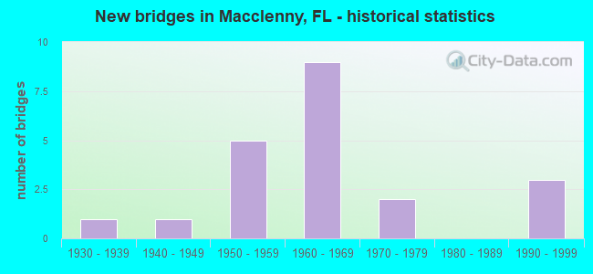
- New bridges - historical statistics
- 11930-1939
- 11940-1949
- 51950-1959
- 91960-1969
- 21970-1979
- 31990-1999

- Reconstructed bridges - Historical Statistics
- 11960-1969
- 01970-1979
- 21980-1989
- 51990-1999
- 02000-2009
- 12010-2019


- Bridge Condition - Deck
- 33.3%Good
- 55.6%Satisfactory
- 11.1%Fair

- Bridge Condition - Superstructure
- 44.4%Good
- 44.4%Satisfactory
- 11.1%Fair

- Bridge Condition - Substructure
- 55.6%Good
- 11.1%Satisfactory
- 33.3%Fair

- Bridge Condition - Channel
- 60.0%Good
- 13.3%Satisfactory
- 26.7%Fair

- Bridge Condition - Culverts
- 33.3%Good
- 33.3%Satisfactory
- 33.3%Fair
Find on map >> Show street view
Structure Number: 270004, Location: 0.5 MI. E. OF MACCLENNY (Lat: 30.286014, Lng: -82.100672), Route carried "on" structure: US 90, Year Built: 1935, Year Reconstructed: 1995, Status: Open, Structure Length: 0.97m (3.18ft), Average Daily Traffic: 4,800 (year 2020), Truck Traffic: 21%, Average Future Daily Traffic: 8,328 (year 2042), Design Load: H 15, Features Intersected: BARBER BAY
Minimum Vertical Clearance: 30+ m (98+ ft), Kilometerpoint: 35.917, Lanes on structure: 2, Base Highway Network: Yes, Owner: State Highway Agency, Approaching Roadway Width: 9.9m (32.5ft), Material/Design: Concrete, Design/Construction: Culvert, Number Of Spans In Main Unit: 3, Length of Maximum Span: 3.0m (9.8ft)
Condition: Channel: Satisfactory, Culverts: Satisfactory, Operating Rating: 57.9 metric tons, Method Used To Determine Operating Rating: Load Factor (LF), Inventory Rating: 34.7 metric tons, Method Used To Determine Inventory Rating: Load Factor (LF), Structural Evaluation: Equal to present minimum criteria, Waterway Adequacy: Equal to present desirable criteria, Approach Roadway Alignment: Equal to present desirable criteria, Designated Inspection Frequency: Every 24 months, Inspection Date: June 2021
Find on map >> Show street view
Structure Number: 270006, Location: 0.7 MI. N. OF I-10 (Lat: 30.268889, Lng: -82.122500), Route carried "on" structure: State highway 121, Year Built: 1970, Year Reconstructed: 2003, Status: Open, Structure Length: 5.35m (17.55ft), Average Daily Traffic: 10,900 (year 2020), Truck Traffic: 22%, Average Future Daily Traffic: 18,912 (year 2042), Design Load: HS 20, Features Intersected: TURKEY CREEK
Minimum Vertical Clearance: 30+ m (98+ ft), Kilometerpoint: 15.858, Lanes on structure: 4, Owner: State Highway Agency, Approaching Roadway Width: 18.6m (61.0ft), Skew: 20 degrees, Material/Design: Prestressed concrete, Design/Construction: Stringer/Multi-beam, Number Of Spans In Main Unit: 4, Length of Maximum Span: 13.4m (44.0ft), Curb or Sidewalk Widths: Left: 1.8m (5.9ft), Right: 1.8m (5.9ft), Curb-To-Curb Width: 18.6m (61.0ft), Out-to-Out Width: 27.3m (89.6ft)
Condition: Deck: Good, Superstructure: Good, Substructure: Good, Channel: Satisfactory, Operating Rating: 66.0 metric tons, Method Used To Determine Operating Rating: Load Factor (LF), Inventory Rating: 39.6 metric tons, Method Used To Determine Inventory Rating: Load Factor (LF), Structural Evaluation: Better than present minimum criteria, Deck Geometry: Equal to present minimum criteria, Waterway Adequacy: Equal to present desirable criteria, Approach Roadway Alignment: Equal to present desirable criteria, Designated Inspection Frequency: Every 24 months, Inspection Date: August 2021, Deck Structure Type: Concrete Cast-file-Place
Find on map >> Show street view
Structure Number: 270007, Location: 1.3 MI NORTH OF US 90 (Lat: 30.295819, Lng: -82.162467), Route carried "on" structure: County highway 125, Year Built: 1951, Status: Open, Structure Length: 0.79m (2.59ft), Average Daily Traffic: 6,500 (year 2021), Truck Traffic: 22%, Average Future Daily Traffic: 10,931 (year 2042), Design Load: HS 20, Features Intersected: NEW HOPE CREEK
Minimum Vertical Clearance: 30+ m (98+ ft), Kilometerpoint: 2.140, Lanes on structure: 2, Owner: County Highway Agency, Approaching Roadway Width: 8.2m (26.9ft), Skew: 1 degrees, Material/Design: Concrete, Design/Construction: Culvert, Number Of Spans In Main Unit: 3, Length of Maximum Span: 2.4m (7.9ft)
Condition: Channel: Fair, Culverts: Fair, Operating Rating: 41.4 metric tons, Method Used To Determine Operating Rating: Load Factor (LF), Inventory Rating: 24.8 metric tons, Method Used To Determine Inventory Rating: Load Factor (LF), Structural Evaluation: Somewhat better than minimum adequacy, Waterway Adequacy: Better than present minimum criteria, Approach Roadway Alignment: Equal to present desirable criteria, Designated Inspection Frequency: Every 24 months, Inspection Date: August 2021
Find on map >> Show street view
Structure Number: 270009, Location: 1.3 MI. N. OF CR-23C (Lat: 30.352258, Lng: -82.129100), Route carried "on" structure: State highway 121, Year Built: 1962, Status: Open, Structure Length: 7.32m (24.02ft), Average Daily Traffic: 2,878 (year 2020), Truck Traffic: 10%, Average Future Daily Traffic: 4,993 (year 2042), Design Load: HS 20, Features Intersected: S. PRONG ST.MARY'S RIVER
Minimum Vertical Clearance: 30+ m (98+ ft), Kilometerpoint: 25.183, Lanes on structure: 2, Base Highway Network: Yes, Owner: State Highway Agency, Approaching Roadway Width: 10.2m (33.5ft), Material/Design: Prestressed concrete, Design/Construction: Slab, Number Of Spans In Main Unit: 8, Length of Maximum Span: 9.1m (29.9ft), Curb-To-Curb Width: 8.5m (27.9ft), Out-to-Out Width: 10.4m (34.1ft)
Condition: Deck: Fair, Superstructure: Fair, Substructure: Fair, Channel: Good, Operating Rating: 59.4 metric tons, Method Used To Determine Operating Rating: Load Factor (LF), Inventory Rating: 47.1 metric tons, Method Used To Determine Inventory Rating: Load Factor (LF), Structural Evaluation: Somewhat better than minimum adequacy, Deck Geometry: Meets minimum limits, Waterway Adequacy: Equal to present desirable criteria, Approach Roadway Alignment: Equal to present desirable criteria, Designated Inspection Frequency: Every 24 months, Inspection Date: Febuary 2022, Deck Structure Type: Concrete Precast Panels, Wearing Surface/Protective System: Wearing Surface: Bituminous
Find on map >> Show street view
Structure Number: 270015, Location: 1 MI. N. OF I-10 (Lat: 30.271144, Lng: -82.117467), Route carried "on" structure: State highway 228, Year Built: 1955, Year Reconstructed: 2003, Status: Open, Structure Length: 0.85m (2.79ft), Average Daily Traffic: 12,000 (year 2020), Truck Traffic: 3%, Average Future Daily Traffic: 20,820 (year 2042), Design Load: H 15, Features Intersected: PRONG OF ST.MARY'S RIVER
Minimum Vertical Clearance: 30+ m (98+ ft), Kilometerpoint: 10.749, Lanes on structure: 2, Owner: State Highway Agency, Approaching Roadway Width: 10.2m (33.5ft), Material/Design: Concrete, Design/Construction: Culvert, Number Of Spans In Main Unit: 3, Length of Maximum Span: 2.7m (8.9ft)
Condition: Channel: Good, Culverts: Fair, Operating Rating: 42.5 metric tons, Method Used To Determine Operating Rating: Load Factor (LF), Inventory Rating: 25.5 metric tons, Method Used To Determine Inventory Rating: Load Factor (LF), Structural Evaluation: Somewhat better than minimum adequacy, Waterway Adequacy: Better than present minimum criteria, Approach Roadway Alignment: Equal to present desirable criteria, Designated Inspection Frequency: Every 24 months, Inspection Date: December 2021
Find on map >> Show street view
Structure Number: 270016, Location: SR-121 over I-10 (Lat: 30.258733, Lng: -82.123019), Route carried "on" structure: State highway 121, Year Built: 1960, Status: Open, Structure Length: 6.71m (22.01ft), Average Daily Traffic: 8,200 (year 2020), Truck Traffic: 14%, Average Future Daily Traffic: 14,227 (year 2042), Design Load: H 20, Features Intersected: I-10 (SR-8)
Minimum Vertical Clearance: 30+ m (98+ ft), Kilometerpoint: 14.743, Lanes on structure: 2, Lanes under structure: 6, Owner: State Highway Agency, Approaching Roadway Width: 9.9m (32.5ft), Material/Design: Prestressed concrete, Design/Construction: Stringer/Multi-beam, Number Of Spans In Main Unit: 4, Length of Maximum Span: 23.2m (76.1ft), Curb-To-Curb Width: 8.5m (27.9ft), Out-to-Out Width: 10.3m (33.8ft)
Condition: Deck: Satisfactory, Superstructure: Good, Substructure: Good, Operating Rating: 51.9 metric tons, Method Used To Determine Operating Rating: Load Factor (LF), Inventory Rating: 34.3 metric tons, Method Used To Determine Inventory Rating: Load Factor (LF), Structural Evaluation: Better than present minimum criteria, Deck Geometry: Meets minimum limits, Underclear: Somewhat better than minimum adequacy, Approach Roadway Alignment: Equal to present minimum criteria, Designated Inspection Frequency: Every 24 months, Inspection Date: November 2020, Deck Structure Type: Concrete Cast-file-Place
Find on map >> Show street view
Structure Number: 270017, Location: 2.4 MI. S. OF I-10 (Lat: 30.229900, Lng: -82.143867), Route carried "on" structure: State highway 121, Year Built: 1952, Year Reconstructed: 1987, Status: Open, Structure Length: 0.97m (3.18ft), Average Daily Traffic: 8,200 (year 2020), Truck Traffic: 19%, Average Future Daily Traffic: 14,227 (year 2042), Design Load: H 15, Features Intersected: HOSPITAL CREEK
Minimum Vertical Clearance: 30+ m (98+ ft), Kilometerpoint: 10.868, Lanes on structure: 2, Owner: State Highway Agency, Approaching Roadway Width: 9.8m (32.2ft), Material/Design: Concrete, Design/Construction: Culvert, Number Of Spans In Main Unit: 3, Length of Maximum Span: 2.4m (7.9ft)
Condition: Channel: Good, Culverts: Good, Operating Rating: 57.2 metric tons, Method Used To Determine Operating Rating: Load Factor (LF), Inventory Rating: 34.5 metric tons, Method Used To Determine Inventory Rating: Load Factor (LF), Structural Evaluation: Better than present minimum criteria, Waterway Adequacy: Better than present minimum criteria, Approach Roadway Alignment: Equal to present desirable criteria, Designated Inspection Frequency: Every 24 months, Inspection Date: July 2021
Find on map >> Show street view
Structure Number: 270018, Location: 3.7 MI. S. OF I-10 (Lat: 30.213419, Lng: -82.153456), Route carried "on" structure: State highway 121, Year Built: 1940, Year Reconstructed: 1988, Status: Open, Structure Length: 0.64m (2.10ft), Average Daily Traffic: 8,200 (year 2020), Truck Traffic: 14%, Average Future Daily Traffic: 14,227 (year 2042), Features Intersected: ST.MARY'S CRK. TRIBUTARY
Minimum Vertical Clearance: 30+ m (98+ ft), Kilometerpoint: 8.813, Lanes on structure: 2, Base Highway Network: Yes, Owner: State Highway Agency, Approaching Roadway Width: 9.9m (32.5ft), Material/Design: Concrete, Design/Construction: Culvert, Number Of Spans In Main Unit: 2, Length of Maximum Span: 3.1m (10.2ft)
Condition: Channel: Good, Culverts: Satisfactory, Inventory Rating: 61.4 metric tons, Method Used To Determine Inventory Rating: Load and Resistance Factor (LRFR), Structural Evaluation: Equal to present minimum criteria, Waterway Adequacy: Equal to present desirable criteria, Approach Roadway Alignment: Equal to present desirable criteria, Designated Inspection Frequency: Every 24 months, Inspection Date: December 2021
Find on map >> Show street view
Structure Number: 270032, Location: 1.1 MI WEST OF SR 121 (Lat: 30.335833, Lng: -82.144167), Route carried "on" structure: County highway 23C, Year Built: 1955, Status: Posted for load, Structure Length: 3.81m (12.50ft), Average Daily Traffic: 1,600 (year 2021), Truck Traffic: 23%, Average Future Daily Traffic: 2,776 (year 2042), Design Load: H 15, Features Intersected: S PRONG TO ST MARYS RVR
Minimum Vertical Clearance: 30+ m (98+ ft), Kilometerpoint: 1.851, Lanes on structure: 2, Owner: County Highway Agency, Approaching Roadway Width: 6.4m (21.0ft), Material/Design: Concrete, Design/Construction: Slab, Number Of Spans In Main Unit: 5, Length of Maximum Span: 7.6m (24.9ft), Curb or Sidewalk Widths: Left: 0.2m (0.7ft), Right: 0.2m (0.7ft), Curb-To-Curb Width: 7.3m (24.0ft), Out-to-Out Width: 7.8m (25.6ft)
Condition: Deck: Satisfactory, Superstructure: Satisfactory, Substructure: Fair, Channel: Good, Operating Rating: 25.8 metric tons, Method Used To Determine Operating Rating: Load and Resistance Factor (LRFR), Inventory Rating: 20.0 metric tons, Method Used To Determine Inventory Rating: Load and Resistance Factor (LRFR), Structural Evaluation: Somewhat better than minimum adequacy, Deck Geometry: Meets minimum limits, Waterway Adequacy: Better than present minimum criteria, Approach Roadway Alignment: Equal to present desirable criteria, Bridge Posting: Required (Relationship of Operating Rating to Maximum Legal Load: 10.0 - 19.9% below), Designated Inspection Frequency: Every 24 months, Underwater Inspection Frequency: Every 24 months, Other Special Inspection Frequency: Every 12 months, Inspection Date: August 2021, Underwater Inspection Date: August 2021, Other Special Inspection Date: August 2021, Deck Structure Type: Concrete Cast-file-Place
Find on map >> Show street view
Structure Number: 270033, Location: 1.2 MI WEST OF SR 121 (Lat: 30.336111, Lng: -82.145278), Route carried "on" structure: County highway 23C, Year Built: 1955, Status: Posted for load, Structure Length: 4.57m (14.99ft), Average Daily Traffic: 1,600 (year 2021), Truck Traffic: 22%, Average Future Daily Traffic: 2,776 (year 2042), Design Load: H 15, Features Intersected: ST MARYS RIVER OVERFLOW
Minimum Vertical Clearance: 30+ m (98+ ft), Kilometerpoint: 1.975, Lanes on structure: 2, Owner: County Highway Agency, Approaching Roadway Width: 6.6m (21.7ft), Material/Design: Concrete, Design/Construction: Slab, Number Of Spans In Main Unit: 6, Length of Maximum Span: 7.6m (24.9ft), Curb or Sidewalk Widths: Left: 0.2m (0.7ft), Right: 0.2m (0.7ft), Curb-To-Curb Width: 7.3m (24.0ft), Out-to-Out Width: 7.8m (25.6ft)
Condition: Deck: Good, Superstructure: Good, Substructure: Satisfactory, Channel: Good, Operating Rating: 29.8 metric tons, Method Used To Determine Operating Rating: Load and Resistance Factor (LRFR), Inventory Rating: 22.5 metric tons, Method Used To Determine Inventory Rating: Load and Resistance Factor (LRFR), Structural Evaluation: Equal to present minimum criteria, Deck Geometry: Meets minimum limits, Waterway Adequacy: Equal to present desirable criteria, Approach Roadway Alignment: Equal to present minimum criteria, Bridge Posting: Required (Relationship of Operating Rating to Maximum Legal Load: 10.0 - 19.9% below), Designated Inspection Frequency: Every 23 months, Underwater Inspection Frequency: Every 23 months, Other Special Inspection Frequency: Every 11 months, Inspection Date: September 2021, Underwater Inspection Date: September 2021, Other Special Inspection Date: September 2021, Deck Structure Type: Concrete Cast-file-Place
Find on map >> Show street view
Structure Number: 270046, Location: 0.1 MI. W. OF SR-228 (Lat: 30.260986, Lng: -82.108883), Route carried "on" structure: Interstate 10, Year Built: 1961, Status: Open, Structure Length: 0.93m (3.05ft), Average Daily Traffic: 23,500 (year 2020), Truck Traffic: 34%, Average Future Daily Traffic: 40,772 (year 2042), Design Load: HS 20+Mod, Features Intersected: TURKEY CREEK
Minimum Vertical Clearance: 30+ m (98+ ft), Kilometerpoint: 34.763, Lanes on structure: 5, Base Highway Network: Yes, Owner: State Highway Agency, Approaching Roadway Width: 28.4m (93.2ft), Skew: 22 degrees, Material/Design: Concrete, Design/Construction: Culvert, Number Of Spans In Main Unit: 3, Length of Maximum Span: 2.6m (8.5ft)
Condition: Channel: Good, Culverts: Fair, Operating Rating: 58.1 metric tons, Method Used To Determine Operating Rating: Load Factor (LF), Inventory Rating: 35.4 metric tons, Method Used To Determine Inventory Rating: Load Factor (LF), Structural Evaluation: Somewhat better than minimum adequacy, Waterway Adequacy: Equal to present desirable criteria, Approach Roadway Alignment: Equal to present desirable criteria, Designated Inspection Frequency: Every 24 months, Underwater Inspection Frequency: Every 24 months, Inspection Date: July 2021, Underwater Inspection Date: July 2021
Find on map >> Show street view
Structure Number: 270047, Location: I-10 WB OVER SR-228 (Lat: 30.263006, Lng: -82.104569), Route carried "on" structure: Interstate 10, Year Built: 1960, Year Reconstructed: 1990, Status: Open, Structure Length: 5.39m (17.68ft), Average Daily Traffic: 11,750 (year 2020), Truck Traffic: 35%, Average Future Daily Traffic: 20,386 (year 2042), Design Load: HS 20+Mod, Features Intersected: SR-228
Minimum Vertical Clearance: 30+ m (98+ ft), Kilometerpoint: 35.212, Lanes on structure: 2, Lanes under structure: 4, Base Highway Network: Yes, Owner: State Highway Agency, Approaching Roadway Width: 11.6m (38.1ft), Skew: 2 degrees, Material/Design: Prestressed concrete, Design/Construction: Stringer/Multi-beam, Number Of Spans In Main Unit: 4, Length of Maximum Span: 15.8m (51.8ft), Curb-To-Curb Width: 12.2m (40.0ft), Out-to-Out Width: 13.0m (42.7ft)
Condition: Deck: Satisfactory, Superstructure: Satisfactory, Substructure: Good, Operating Rating: 54.4 metric tons, Method Used To Determine Operating Rating: Load Testing, Inventory Rating: 32.7 metric tons, Method Used To Determine Inventory Rating: Load Testing, Structural Evaluation: Equal to present minimum criteria, Deck Geometry: Better than present minimum criteria, Underclear: Meets minimum limits, Approach Roadway Alignment: Equal to present desirable criteria, Designated Inspection Frequency: Every 24 months, Inspection Date: Febuary 2021, Deck Structure Type: Concrete Cast-file-Place
Find on map >> Show street view
Structure Number: 270053, Location: 1.2 MI. W OF SR-121 (Lat: 30.260131, Lng: -82.142786), Route carried "on" structure: Interstate 10, Year Built: 1961, Year Reconstructed: 1973, Status: Open, Structure Length: 0.64m (2.10ft), Average Daily Traffic: 29,000 (year 2020), Truck Traffic: 35%, Average Future Daily Traffic: 50,315 (year 2042), Design Load: HS 15, Features Intersected: PRONG OF ST.MARY'S RIVER
Minimum Vertical Clearance: 30+ m (98+ ft), Kilometerpoint: 31.414, Lanes on structure: 4, Base Highway Network: Yes, Owner: State Highway Agency, Approaching Roadway Width: 23.3m (76.4ft), Skew: 22 degrees, Material/Design: Concrete, Design/Construction: Culvert, Number Of Spans In Main Unit: 2, Length of Maximum Span: 3.0m (9.8ft)
Condition: Channel: Fair, Culverts: Satisfactory, Operating Rating: 87.1 metric tons, Method Used To Determine Operating Rating: Load Factor (LF), Inventory Rating: 52.2 metric tons, Method Used To Determine Inventory Rating: Load Factor (LF), Structural Evaluation: Equal to present minimum criteria, Waterway Adequacy: Equal to present desirable criteria, Approach Roadway Alignment: Equal to present desirable criteria, Designated Inspection Frequency: Every 24 months, Inspection Date: November 2020
Find on map >> Show street view
Structure Number: 270057, Location: I-10 EB OVER SR-228 (Lat: 30.262836, Lng: -82.104289), Route carried "on" structure: Interstate 10, Year Built: 1960, Year Reconstructed: 1990, Status: Open, Structure Length: 5.39m (17.68ft), Average Daily Traffic: 17,500 (year 2020), Truck Traffic: 35%, Average Future Daily Traffic: 30,362 (year 2042), Design Load: HS 20+Mod, Features Intersected: SR-228
Minimum Vertical Clearance: 30+ m (98+ ft), Kilometerpoint: 35.229, Lanes on structure: 2, Lanes under structure: 4, Base Highway Network: Yes, Owner: State Highway Agency, Approaching Roadway Width: 11.4m (37.4ft), Skew: 2 degrees, Material/Design: Prestressed concrete, Design/Construction: Stringer/Multi-beam, Number Of Spans In Main Unit: 4, Length of Maximum Span: 15.8m (51.8ft), Curb-To-Curb Width: 12.2m (40.0ft), Out-to-Out Width: 13.0m (42.7ft)
Condition: Deck: Satisfactory, Superstructure: Satisfactory, Substructure: Good, Operating Rating: 54.4 metric tons, Method Used To Determine Operating Rating: Load Testing, Inventory Rating: 32.7 metric tons, Method Used To Determine Inventory Rating: Load Testing, Structural Evaluation: Equal to present minimum criteria, Deck Geometry: Better than present minimum criteria, Underclear: Meets minimum limits, Approach Roadway Alignment: Equal to present desirable criteria, Designated Inspection Frequency: Every 24 months, Inspection Date: Febuary 2021, Deck Structure Type: Concrete Cast-file-Place
Find on map >> Show street view
Structure Number: 27007, Location: 1.3 MI. W. OF SR-121 (Lat: 30.279167, Lng: -82.144722), Route carried "on" structure: US 90, Year Built: 1998, Status: Open, Structure Length: 12.20m (40.03ft), Average Daily Traffic: 11,900 (year 2020), Truck Traffic: 22%, Average Future Daily Traffic: 20,646 (year 2042), Design Load: HS 20, Features Intersected: LITTLE ST. MARY RIVER
Minimum Vertical Clearance: 30+ m (98+ ft), Kilometerpoint: 31.570, Lanes on structure: 4, Owner: State Highway Agency, Approaching Roadway Width: 20.9m (68.6ft), Material/Design: Concrete continuous, Design/Construction: Slab, Number Of Spans In Main Unit: 11, Length of Maximum Span: 11.4m (37.4ft), Curb or Sidewalk Widths: Left: 2.5m (8.2ft), Right: 2.5m (8.2ft), Curb-To-Curb Width: 20.9m (68.6ft), Out-to-Out Width: 27.1m (88.9ft)
Condition: Deck: Good, Superstructure: Good, Substructure: Good, Channel: Good, Operating Rating: 74.1 metric tons, Method Used To Determine Operating Rating: Load Factor (LF), Inventory Rating: 44.5 metric tons, Method Used To Determine Inventory Rating: Load Factor (LF), Structural Evaluation: Better than present minimum criteria, Deck Geometry: Superior to present desirable criteria, Waterway Adequacy: Superior to present desirable criteria, Approach Roadway Alignment: Equal to present desirable criteria, Designated Inspection Frequency: Every 24 months, Inspection Date: December 2020, Deck Structure Type: Concrete Cast-file-Place
Find on map >> Show street view
Structure Number: 274128, Location: 0.6 MI WEST OF SR 121 (Lat: 30.340833, Lng: -82.136111), Route carried "on" structure: County highway , Year Built: 1970, Status: Posted for load, Structure Length: 1.14m (3.74ft), Average Daily Traffic: 71 (year 2021), Truck Traffic: 2%, Average Future Daily Traffic: 123 (year 2042), Features Intersected: MT ZION CREEK, Facility Carried by Structure: HARLEY THRIFT ROAD
Minimum Vertical Clearance: 30+ m (98+ ft), Kilometerpoint: 0.000, Lanes on structure: 1, Owner: County Highway Agency, Approaching Roadway Width: 3.9m (12.8ft), Material/Design: Concrete, Design/Construction: Slab, Number Of Spans In Main Unit: 3, Length of Maximum Span: 3.8m (12.5ft), Curb or Sidewalk Widths: Left: 0.2m (0.7ft), Right: 0.2m (0.7ft), Curb-To-Curb Width: 3.4m (11.2ft), Out-to-Out Width: 3.8m (12.5ft)
Condition: Deck: Satisfactory, Superstructure: Satisfactory, Substructure: Fair, Channel: Fair, Operating Rating: 21.9 metric tons, Method Used To Determine Operating Rating: Load and Resistance Factor (LRFR), Inventory Rating: 17.0 metric tons, Method Used To Determine Inventory Rating: Load and Resistance Factor (LRFR), Structural Evaluation: Somewhat better than minimum adequacy, Deck Geometry: High priority of corrective action, Waterway Adequacy: Better than present minimum criteria, Approach Roadway Alignment: Equal to present minimum criteria, Bridge Posting: Required (Relationship of Operating Rating to Maximum Legal Load: 10.0 - 19.9% below), Length Of Structure Improvement: 1.16m (3.81ft), Designated Inspection Frequency: Every 24 months, Other Special Inspection Frequency: Every 12 months, Inspection Date: August 2021, Other Special Inspection Date: August 2021, Bridge Improvement Cost: $175,000, Roadway Improvement Cost: $45,000, Total Project Cost: $242,000, Deck Structure Type: Concrete Precast Panels
Find on map >> Show street view
Structure Number: 27415, Location: 1.1 MI NORTH OF US 90 (Lat: 30.296583, Lng: -82.135528), Route carried "on" structure: County highway 23A, Year Built: 1999, Year Reconstructed: 2010, Status: Open, Structure Length: 0.72m (2.36ft), Average Daily Traffic: 1,851 (year 2021), Truck Traffic: 16%, Average Future Daily Traffic: 3,211 (year 2042), Design Load: HS 20, Features Intersected: BARBER BAY SLOUGH
Minimum Vertical Clearance: 30+ m (98+ ft), Kilometerpoint: 0.000, Lanes on structure: 2, Owner: County Highway Agency, Approaching Roadway Width: 8.0m (26.2ft), Skew: 3 degrees, Material/Design: Concrete, Design/Construction: Culvert, Number Of Spans In Main Unit: 2, Length of Maximum Span: 3.3m (10.8ft)
Condition: Channel: Fair, Culverts: Good, Operating Rating: 46.9 metric tons, Method Used To Determine Operating Rating: Load Factor (LF), Inventory Rating: 28.1 metric tons, Method Used To Determine Inventory Rating: Load Factor (LF), Structural Evaluation: Better than present minimum criteria, Waterway Adequacy: Equal to present desirable criteria, Approach Roadway Alignment: Equal to present desirable criteria, Designated Inspection Frequency: Every 24 months, Inspection Date: September 2021
Find on map >> Show street view
Structure Number: 274151, Location: 2.9 MI NORTH OF US 90 (Lat: 30.321778, Lng: -82.137667), Route carried "on" structure: County highway 23A, Year Built: 1999, Status: Open, Structure Length: 0.74m (2.43ft), Average Daily Traffic: 2,881 (year 2021), Truck Traffic: 8%, Average Future Daily Traffic: 4,999 (year 2042), Design Load: HS 20, Features Intersected: BARBER BAY SLOUGH
Minimum Vertical Clearance: 30+ m (98+ ft), Kilometerpoint: 0.000, Lanes on structure: 2, Owner: County Highway Agency, Approaching Roadway Width: 5.8m (19.0ft), Skew: 4 degrees, Material/Design: Concrete, Design/Construction: Culvert, Number Of Spans In Main Unit: 2, Length of Maximum Span: 3.5m (11.5ft)
Condition: Channel: Good, Culverts: Good, Operating Rating: 56.0 metric tons, Method Used To Determine Operating Rating: Load Factor (LF), Inventory Rating: 33.6 metric tons, Method Used To Determine Inventory Rating: Load Factor (LF), Structural Evaluation: Better than present minimum criteria, Waterway Adequacy: Equal to present desirable criteria, Approach Roadway Alignment: Equal to present desirable criteria, Designated Inspection Frequency: Every 24 months, Inspection Date: September 2021
Find on map >> Show street view
Structure Number: 270016, Location: SR-121 over I-10 (Lat: 30.258733, Lng: -82.123019), Route carried "under" structure: Interstate 10, Year Built: 1960, Structure Length: 0. m, Average Daily Traffic: 23,500 (year 2020), Truck Traffic: 35%, Features Intersected: I-10 (SR-8), Facility Carried by Structure: SR-121
Minimum Vertical Clearance: 5.03m (16.50ft), Kilometerpoint: 33.313, Lanes on structure: 2, Lanes under structure: 6, Material/Design: Prestressed concrete, Design/Construction: Stringer/Multi-beam, Length of Maximum Span: 23.2m (76.1ft)
Find on map >> Show street view
Structure Number: 270047, Location: I-10 WB OVER SR-228 (Lat: 30.263006, Lng: -82.104569), Route carried "under" structure: State highway 228, Year Built: 1960, Structure Length: 0. m, Average Daily Traffic: 12,000 (year 2020), Truck Traffic: 3%, Features Intersected: SR-228, Facility Carried by Structure: I-10 WB SR-8
Minimum Vertical Clearance: 4.45m (14.60ft), Kilometerpoint: 9.210, Lanes on structure: 2, Lanes under structure: 4, Material/Design: Prestressed concrete, Design/Construction: Stringer/Multi-beam, Length of Maximum Span: 15.8m (51.8ft)
Find on map >> Show street view
Structure Number: 270057, Location: I-10 EB OVER SR-228 (Lat: 30.262836, Lng: -82.104289), Route carried "under" structure: State highway 228, Year Built: 1960, Structure Length: 0. m, Average Daily Traffic: 12,000 (year 2020), Truck Traffic: 3%, Features Intersected: SR-228, Facility Carried by Structure: I-10 EB SR-8
Minimum Vertical Clearance: 4.51m (14.80ft), Kilometerpoint: 9.156, Lanes on structure: 2, Lanes under structure: 4, Material/Design: Prestressed concrete, Design/Construction: Stringer/Multi-beam, Length of Maximum Span: 15.8m (51.8ft)