Bridge Statistics for Mableton, Georgia (GA)
Condition, Traffic, Stress, Structural Evaluation, Project Costs
- National Bridge Inventory (NBI) Statistics
- 32Number of bridges
- 427ft / 130mTotal length
- $31,509,000Total costs
- 832,870Total average daily traffic
- 9,015Total average daily truck traffic
- National Bridge Inventory (NBI) Registered Bridges for Mableton
- No street view available for this location
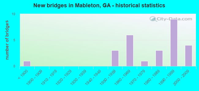
- New bridges - historical statistics
- 1Before 1900
- 31950-1959
- 61960-1969
- 11970-1979
- 31980-1989
- 91990-1999
- 42000-2009

- Reconstructed bridges - Historical Statistics
- 31970-1979
- 21980-1989
- 01990-1999
- 12000-2009


- Bridge Condition - Deck
- 81.0%Good
- 19.0%Satisfactory

- Bridge Condition - Superstructure
- 23.8%Very good
- 76.2%Good

- Bridge Condition - Substructure
- 4.8%Very good
- 85.7%Good
- 9.5%Satisfactory

- Bridge Condition - Channel
- 38.9%Very good
- 50.0%Good
- 11.1%Satisfactory

- Bridge Condition - Culverts
- 83.3%Good
- 16.7%Fair
Find on map >> Show street view
Structure Number: 670062, Location: 2.6 MI NE OF AUSTELL (Lat: 33.843617, Lng: -84.609672), Route carried "on" structure: State highway 5, Year Built: 1966, Year Reconstructed: 1987, Status: Open, Structure Length: 3.23m (10.60ft), Average Daily Traffic: 31,660 (year 2012), Truck Traffic: 1%, Average Future Daily Traffic: 47,490 (year 2032), Design Load: HS 20+Mod, Features Intersected: CSX RR (ABANDONED)
Minimum Vertical Clearance: 30+ m (98+ ft), Kilometerpoint: 6.437, Lanes on structure: 5, Base Highway Network: Yes, Owner: State Highway Agency, Approaching Roadway Width: 17.1m (56.1ft), Skew: 21 degrees, Material/Design: Steel, Design/Construction: Stringer/Multi-beam, Number Of Spans In Main Unit: 1, Length of Maximum Span: 32.3m (106.0ft), Curb or Sidewalk Widths: Left: 1.8m (5.9ft), Right: 1.8m (5.9ft), Curb-To-Curb Width: 22.9m (75.1ft), Out-to-Out Width: 26.4m (86.6ft)
Condition: Deck: Good, Superstructure: Good, Substructure: Good, Operating Rating: 52.6 metric tons, Method Used To Determine Operating Rating: Load Factor (LF), Inventory Rating: 31.7 metric tons, Method Used To Determine Inventory Rating: Load Factor (LF), Structural Evaluation: Better than present minimum criteria, Deck Geometry: Equal to present minimum criteria, Approach Roadway Alignment: Equal to present desirable criteria, Designated Inspection Frequency: Every 24 months, Inspection Date: March 2021, Deck Structure Type: Concrete Cast-file-Place
Find on map >> Show street view
Structure Number: 670089, Location: 5.5 MI SE OF AUSTELL (Lat: 33.772881, Lng: -84.551900), Route carried "on" structure: Interstate 20, Year Built: 1963, Year Reconstructed: 1979, Status: Open, Structure Length: 4.48m (14.70ft), Average Daily Traffic: 125,850 (year 2012), Truck Traffic: 1%, Average Future Daily Traffic: 188,775 (year 2032), Design Load: HS 20+Mod, Features Intersected: M-9025 SIX FLAGS ROAD
Minimum Vertical Clearance: 30+ m (98+ ft), Kilometerpoint: 75.639, Lanes on structure: 7, Lanes under structure: 4, Base Highway Network: Yes, Owner: State Highway Agency, Approaching Roadway Width: 39.3m (128.9ft), Skew: 30 degrees, Material/Design: Steel, Design/Construction: Stringer/Multi-beam, Number Of Spans In Main Unit: 3, Length of Maximum Span: 16.2m (53.1ft), Curb-To-Curb Width: 39.6m (129.9ft), Out-to-Out Width: 41.8m (137.1ft)
Condition: Deck: Good, Superstructure: Good, Substructure: Good, Operating Rating: 36.2 metric tons, Method Used To Determine Operating Rating: Load Factor (LF), Inventory Rating: 20.8 metric tons, Method Used To Determine Inventory Rating: Load Factor (LF), Structural Evaluation: Somewhat better than minimum adequacy, Deck Geometry: Superior to present desirable criteria, Underclear: High priority of corrective action, Approach Roadway Alignment: Equal to present desirable criteria, Designated Inspection Frequency: Every 24 months, Inspection Date: April 2021, Deck Structure Type: Concrete Cast-file-Place, Wearing Surface/Protective System: Wearing Surface: Monolithic Concrete
Find on map >> Show street view
Structure Number: 67009, Location: 6.2 MI SE OF AUSTELL (Lat: 33.769739, Lng: -84.539378), Route carried "on" structure: Interstate 20, Year Built: 1963, Year Reconstructed: 1979, Status: Open, Structure Length: 13.78m (45.21ft), Average Daily Traffic: 125,850 (year 2012), Truck Traffic: 1%, Average Future Daily Traffic: 188,775 (year 2032), Design Load: HS 20+Mod, Features Intersected: CHATTAHOOCHEE RIVER
Minimum Vertical Clearance: 30+ m (98+ ft), Kilometerpoint: 77.249, Lanes on structure: 8, Base Highway Network: Yes, Owner: State Highway Agency, Approaching Roadway Width: 39.3m (128.9ft), Skew: 31 degrees, Material/Design: Steel continuous, Design/Construction: Stringer/Multi-beam, Number Of Spans In Main Unit: 5, Length of Maximum Span: 33.2m (108.9ft), Curb-To-Curb Width: 39.6m (129.9ft), Out-to-Out Width: 41.8m (137.1ft)
Condition: Deck: Good, Superstructure: Good, Substructure: Satisfactory, Channel: Satisfactory, Operating Rating: 27.2 metric tons, Method Used To Determine Operating Rating: Load Factor (LF), Inventory Rating: 16.3 metric tons, Method Used To Determine Inventory Rating: Load Factor (LF), Structural Evaluation: Meets minimum limits, Deck Geometry: Superior to present desirable criteria, Waterway Adequacy: Superior to present desirable criteria, Approach Roadway Alignment: Equal to present desirable criteria, Designated Inspection Frequency: Every 24 months, Underwater Inspection Frequency: Every 60 months, Inspection Date: September 2021, Underwater Inspection Date: September 2018, Bridge Improvement Cost: $4,656,000, Roadway Improvement Cost: $466,000, Total Project Cost: $6,984,000, Deck Structure Type: Concrete Cast-file-Place, Wearing Surface/Protective System: Wearing Surface: Bituminous
Find on map >> Show street view
Structure Number: 670135, Location: 4.1 MI SE OF AUSTELL (Lat: 33.775100, Lng: -84.578828), Route carried "on" structure: County highway 2626, Year Built: 1963, Status: Open, Structure Length: 13.41m (44.00ft), Average Daily Traffic: 12,570 (year 2012), Truck Traffic: 1%, Average Future Daily Traffic: 18,855 (year 2032), Design Load: HS 15, Features Intersected: I-20, Facility Carried by Structure: FACTORY SHOALS RD
Minimum Vertical Clearance: 30+ m (98+ ft), Kilometerpoint: 3.219, Lanes on structure: 2, Lanes under structure: 8, Base Highway Network: Yes, Owner: State Highway Agency, Approaching Roadway Width: 6.7m (22.0ft), Skew: 5 degrees, Material/Design: Steel, Design/Construction: Stringer/Multi-beam, Number Of Spans In Main Unit: 4, Length of Maximum Span: 36.0m (118.1ft), Curb or Sidewalk Widths: Left: 0.6m (2.0ft), Right: 0.6m (2.0ft), Curb-To-Curb Width: 8.0m (26.2ft), Out-to-Out Width: 9.5m (31.2ft)
Condition: Deck: Satisfactory, Superstructure: Good, Substructure: Good, Operating Rating: 33.5 metric tons, Method Used To Determine Operating Rating: Load Factor (LF), Inventory Rating: 19.9 metric tons, Method Used To Determine Inventory Rating: Load Factor (LF), Structural Evaluation: Somewhat better than minimum adequacy, Deck Geometry: High priority of corrective action, Underclear: High priority of corrective action, Approach Roadway Alignment: Better than present minimum criteria, Length Of Structure Improvement: 53.68m (176.12ft), Designated Inspection Frequency: Every 24 months, Inspection Date: September 2021, Bridge Improvement Cost: $1,719,000, Roadway Improvement Cost: $172,000, Total Project Cost: $2,579,000, Deck Structure Type: Concrete Cast-file-Place, Wearing Surface/Protective System: Wearing Surface: Monolithic Concrete
Find on map >> Show street view
Structure Number: 670146, Location: SOUTH EAST OF AUSTELL CIT (Lat: 33.804997, Lng: -84.619789), Route carried "on" structure: City street 9005, Year Built: 1981, Year Reconstructed: 2008, Status: Open, Structure Length: 3.02m (9.91ft), Average Daily Traffic: 27,050 (year 2012), Truck Traffic: 1%, Average Future Daily Traffic: 40,575 (year 2032), Design Load: HS 20, Features Intersected: BUTTERMILK CREEK, Facility Carried by Structure: MAXHAM ROAD
Minimum Vertical Clearance: 30+ m (98+ ft), Kilometerpoint: 0.000, Lanes on structure: 4, Base Highway Network: Yes, Owner: County Highway Agency, Approaching Roadway Width: 15.5m (50.9ft), Skew: 20 degrees, Material/Design: Concrete, Design/Construction: Tee Beam, Number Of Spans In Main Unit: 3, Length of Maximum Span: 10.1m (33.1ft), Curb or Sidewalk Widths: Left: 1.8m (5.9ft), Right: 1.8m (5.9ft), Curb-To-Curb Width: 15.2m (49.9ft), Out-to-Out Width: 25.0m (82.0ft)
Condition: Deck: Satisfactory, Superstructure: Good, Substructure: Good, Channel: Very good, Operating Rating: 40.8 metric tons, Method Used To Determine Operating Rating: Load Factor (LF), Inventory Rating: 24.4 metric tons, Method Used To Determine Inventory Rating: Load Factor (LF), Structural Evaluation: Equal to present minimum criteria, Deck Geometry: High priority of corrective action, Waterway Adequacy: Superior to present desirable criteria, Approach Roadway Alignment: Equal to present desirable criteria, Designated Inspection Frequency: Every 24 months, Inspection Date: June 2021, Bridge Improvement Cost: $598,000, Roadway Improvement Cost: $60,000, Total Project Cost: $897,000, Deck Structure Type: Concrete Cast-file-Place
Find on map >> Show street view
Structure Number: 670169, Location: 3.4 MI EAST OF AUSTELL (Lat: 33.820539, Lng: -84.576008), Route carried "on" structure: City street 9038, Year Built: 1974, Status: Open, Structure Length: 6.00m (19.69ft), Average Daily Traffic: 29,860 (year 2012), Truck Traffic: 1%, Average Future Daily Traffic: 44,790 (year 2032), Design Load: HS 20+Mod, Features Intersected: NS RAILROAD (719837S), Facility Carried by Structure: FLOYD ROAD
Minimum Vertical Clearance: 30+ m (98+ ft), Kilometerpoint: 0.000, Lanes on structure: 4, Base Highway Network: Yes, Owner: County Highway Agency, Approaching Roadway Width: 8.5m (27.9ft), Skew: 2 degrees, Material/Design: Steel continuous, Design/Construction: Stringer/Multi-beam, Number Of Spans In Main Unit: 3, Length of Maximum Span: 24.1m (79.1ft), Curb or Sidewalk Widths: Left: 1.2m (3.9ft), Right: 1.2m (3.9ft), Curb-To-Curb Width: 17.2m (56.4ft), Out-to-Out Width: 20.3m (66.6ft)
Condition: Deck: Satisfactory, Superstructure: Good, Substructure: Good, Operating Rating: 45.3 metric tons, Method Used To Determine Operating Rating: Load Factor (LF), Inventory Rating: 27.2 metric tons, Method Used To Determine Inventory Rating: Load Factor (LF), Structural Evaluation: Equal to present minimum criteria, Deck Geometry: Somewhat better than minimum adequacy, Underclear: Equal to present minimum criteria, Approach Roadway Alignment: Equal to present desirable criteria, Designated Inspection Frequency: Every 24 months, Inspection Date: April 2021, Bridge Improvement Cost: $1,190,000, Roadway Improvement Cost: $119,000, Total Project Cost: $1,784,000, Deck Structure Type: Concrete Cast-file-Place
Find on map >> Show street view
Structure Number: 670172, Location: 5 MI SOUTH EAST OF AUSTEL (Lat: 33.773947, Lng: -84.560508), Route carried "on" structure: City street 9328, Year Built: 1963, Year Reconstructed: 1980, Status: Posted for load, Structure Length: 9.27m (30.41ft), Average Daily Traffic: 9,490 (year 2012), Truck Traffic: 1%, Average Future Daily Traffic: 14,235 (year 2032), Design Load: HS 20+Mod, Features Intersected: I-20, Facility Carried by Structure: SIX FLAGS DRIVE
Minimum Vertical Clearance: 30+ m (98+ ft), Kilometerpoint: 1.609, Lanes on structure: 5, Lanes under structure: 7, Base Highway Network: Yes, Owner: State Highway Agency, Approaching Roadway Width: 15.8m (51.8ft), Skew: 3 degrees, Material/Design: Steel continuous, Design/Construction: Stringer/Multi-beam, Number Of Spans In Main Unit: 4, Length of Maximum Span: 24.7m (81.0ft), Curb or Sidewalk Widths: Left: 1.8m (5.9ft), Right: 1.8m (5.9ft), Curb-To-Curb Width: 19.6m (64.3ft), Out-to-Out Width: 23.8m (78.1ft)
Condition: Deck: Good, Superstructure: Good, Substructure: Good, Operating Rating: 17.2 metric tons, Method Used To Determine Operating Rating: Load Factor (LF), Inventory Rating: 9.9 metric tons, Method Used To Determine Inventory Rating: Load Factor (LF), Structural Evaluation: High priority of corrective action, Deck Geometry: Meets minimum limits, Underclear: Meets minimum limits, Approach Roadway Alignment: Equal to present desirable criteria, Bridge Posting: Required (Relationship of Operating Rating to Maximum Legal Load: 30.0 - 39.9% below), Designated Inspection Frequency: Every 24 months, Inspection Date: September 2021, Bridge Improvement Cost: $2,160,000, Roadway Improvement Cost: $216,000, Total Project Cost: $3,239,000, Deck Structure Type: Concrete Cast-file-Place, Wearing Surface/Protective System: Wearing Surface: Bituminous
Find on map >> Show street view
Structure Number: 670193, Location: 2.5 MI E POWDER SPRINGS (Lat: 33.859125, Lng: -84.618067), Route carried "on" structure: City street 9034, Year Built: 1986, Status: Open, Structure Length: 5.03m (16.50ft), Average Daily Traffic: 34,570 (year 2012), Truck Traffic: 1%, Average Future Daily Traffic: 51,855 (year 2032), Design Load: HS 20, Features Intersected: OLLEY CREEK, Facility Carried by Structure: EAST-WEST CONN
Minimum Vertical Clearance: 30+ m (98+ ft), Kilometerpoint: 1.609, Lanes on structure: 4, Base Highway Network: Yes, Owner: County Highway Agency, Approaching Roadway Width: 14.6m (47.9ft), Skew: 23 degrees, Material/Design: Prestressed concrete, Design/Construction: Stringer/Multi-beam, Number Of Spans In Main Unit: 5, Length of Maximum Span: 10.1m (33.1ft), Curb-To-Curb Width: 26.8m (87.9ft), Out-to-Out Width: 27.8m (91.2ft)
Condition: Deck: Good, Superstructure: Very good, Substructure: Good, Channel: Good, Operating Rating: 45.3 metric tons, Method Used To Determine Operating Rating: Load Factor (LF), Inventory Rating: 27.2 metric tons, Method Used To Determine Inventory Rating: Load Factor (LF), Structural Evaluation: Equal to present minimum criteria, Deck Geometry: Superior to present desirable criteria, Waterway Adequacy: Superior to present desirable criteria, Approach Roadway Alignment: Equal to present desirable criteria, Designated Inspection Frequency: Every 24 months, Inspection Date: April 2021, Bridge Improvement Cost: $996,000, Roadway Improvement Cost: $100,000, Total Project Cost: $1,495,000, Deck Structure Type: Concrete Cast-file-Place
Find on map >> Show street view
Structure Number: 670212, Location: 5.5 MI S OF SMYRNA (Lat: 33.803358, Lng: -84.521339), Route carried "on" structure: US 78, Year Built: 1995, Status: Open, Structure Length: 6.40m (21.00ft), Average Daily Traffic: 23,280 (year 2012), Truck Traffic: 4%, Average Future Daily Traffic: 34,920 (year 2032), Design Load: HS 20+Mod, Features Intersected: NICKAJACK CREEK
Minimum Vertical Clearance: 30+ m (98+ ft), Kilometerpoint: 11.265, Lanes on structure: 5, Base Highway Network: Yes, Owner: State Highway Agency, Approaching Roadway Width: 20.1m (65.9ft), Skew: 1 degrees, Material/Design: Prestressed concrete, Design/Construction: Stringer/Multi-beam, Number Of Spans In Main Unit: 3, Length of Maximum Span: 21.3m (69.9ft), Curb or Sidewalk Widths: Left: 1.8m (5.9ft), Right: 1.8m (5.9ft), Curb-To-Curb Width: 20.1m (65.9ft), Out-to-Out Width: 24.6m (80.7ft)
Condition: Deck: Good, Superstructure: Good, Substructure: Good, Channel: Good, Operating Rating: 41.7 metric tons, Method Used To Determine Operating Rating: Load Factor (LF), Inventory Rating: 24.4 metric tons, Method Used To Determine Inventory Rating: Load Factor (LF), Structural Evaluation: Equal to present minimum criteria, Deck Geometry: Somewhat better than minimum adequacy, Waterway Adequacy: Superior to present desirable criteria, Approach Roadway Alignment: Equal to present desirable criteria, Designated Inspection Frequency: Every 24 months, Inspection Date: April 2021, Bridge Improvement Cost: $1,492,000, Roadway Improvement Cost: $149,000, Total Project Cost: $2,238,000, Deck Structure Type: Concrete Cast-file-Place
Find on map >> Show street view
Structure Number: 675083, Location: 2.5 MILES SOUTH WEST OF S (Lat: 33.849167, Lng: -84.558925), Route carried "on" structure: County highway 1782, Year Built: 1872, Status: Posted for load, Structure Length: 3.57m (11.71ft), Average Daily Traffic: 5,170 (year 2012), Truck Traffic: 1%, Average Future Daily Traffic: 7,755 (year 2032), Features Intersected: NICKAJACK CREEK, Facility Carried by Structure: CONCORD RD (COVERE
Minimum Vertical Clearance: 2.43m (7.97ft), Kilometerpoint: 11.265, Lanes on structure: 1, Base Highway Network: Yes, Owner: County Highway Agency, Approaching Roadway Width: 5.2m (17.1ft), Material/Design: Steel, Design/Construction: Stringer/Multi-beam, Number Of Spans In Main Unit: 5, Length of Maximum Span: 8.8m (28.9ft), Curb-To-Curb Width: 4.0m (13.1ft), Out-to-Out Width: 4.9m (16.1ft)
Condition: Deck: Good, Superstructure: Good, Substructure: Satisfactory, Channel: Very good, Operating Rating: 17.2 metric tons, Method Used To Determine Operating Rating: Load Factor (LF), Inventory Rating: 11.7 metric tons, Method Used To Determine Inventory Rating: Load Factor (LF), Structural Evaluation: High priority of replacement, Deck Geometry: High priority of replacement, Waterway Adequacy: Superior to present desirable criteria, Approach Roadway Alignment: Somewhat better than minimum adequacy, Bridge Posting: Required (Relationship of Operating Rating to Maximum Legal Load: > 39.9% below), Length Of Structure Improvement: 44.29m (145.31ft), Designated Inspection Frequency: Every 24 months, Inspection Date: August 2021, Bridge Improvement Cost: $332,000, Roadway Improvement Cost: $33,000, Total Project Cost: $499,000, Deck Structure Type: Wood or Timber, Wearing Surface/Protective System: Wearing Surface: Wood or Timber
Find on map >> Show street view
Structure Number: 675096, Location: 3.2 MI E OF AUSTELL (Lat: 33.819278, Lng: -84.580508), Route carried "on" structure: County highway 2080, Year Built: 1994, Status: Open, Structure Length: 3.69m (12.11ft), Average Daily Traffic: 1,930 (year 2012), Truck Traffic: 1%, Average Future Daily Traffic: 2,895 (year 2032), Design Load: HS 20+Mod, Features Intersected: NORSOU RAILROAD(719836K), Facility Carried by Structure: OLD FLOYD ROAD
Minimum Vertical Clearance: 30+ m (98+ ft), Kilometerpoint: 1.609, Lanes on structure: 2, Base Highway Network: Yes, Owner: County Highway Agency, Approaching Roadway Width: 8.5m (27.9ft), Skew: 1 degrees, Material/Design: Prestressed concrete, Design/Construction: Box Beam or Girders - Multiple, Number Of Spans In Main Unit: 3, Length of Maximum Span: 16.8m (55.1ft), Curb or Sidewalk Widths: Left: 1.8m (5.9ft), Right: 0.0m, Curb-To-Curb Width: 8.5m (27.9ft), Out-to-Out Width: 11.4m (37.4ft)
Condition: Deck: Good, Superstructure: Good, Substructure: Good, Operating Rating: 56.2 metric tons, Method Used To Determine Operating Rating: Load Factor (LF), Inventory Rating: 24.4 metric tons, Method Used To Determine Inventory Rating: Load Factor (LF), Structural Evaluation: Equal to present minimum criteria, Deck Geometry: Somewhat better than minimum adequacy, Underclear: Equal to present minimum criteria, Approach Roadway Alignment: Equal to present desirable criteria, Designated Inspection Frequency: Every 24 months, Inspection Date: August 2021, Bridge Improvement Cost: $473,000, Roadway Improvement Cost: $47,000, Total Project Cost: $709,000, Deck Structure Type: Concrete Precast Panels
Find on map >> Show street view
Structure Number: 675112, Location: 1.7 MILES EAST OF AUSTELL (Lat: 33.823139, Lng: -84.606969), Route carried "on" structure: County highway 4581, Year Built: 1952, Status: Open, Structure Length: 0.94m (3.08ft), Average Daily Traffic: 1,930 (year 2012), Truck Traffic: 1%, Average Future Daily Traffic: 2,895 (year 2032), Features Intersected: BUTTERMILK CREEK, Facility Carried by Structure: HARRIS STREET
Minimum Vertical Clearance: 30+ m (98+ ft), Kilometerpoint: 0.000, Lanes on structure: 2, Base Highway Network: Yes, Owner: County Highway Agency, Approaching Roadway Width: 6.1m (20.0ft), Material/Design: Steel, Design/Construction: Stringer/Multi-beam, Number Of Spans In Main Unit: 1, Length of Maximum Span: 9.4m (30.8ft), Curb-To-Curb Width: 6.7m (22.0ft), Out-to-Out Width: 6.8m (22.3ft)
Condition: Deck: Good, Superstructure: Good, Substructure: Good, Channel: Satisfactory, Operating Rating: 42.6 metric tons, Method Used To Determine Operating Rating: Load Factor (LF), Inventory Rating: 25.4 metric tons, Method Used To Determine Inventory Rating: Load Factor (LF), Structural Evaluation: Equal to present minimum criteria, Deck Geometry: High priority of corrective action, Waterway Adequacy: Superior to present desirable criteria, Approach Roadway Alignment: Equal to present desirable criteria, Designated Inspection Frequency: Every 24 months, Inspection Date: June 2021, Bridge Improvement Cost: $121,000, Roadway Improvement Cost: $12,000, Total Project Cost: $182,000, Deck Structure Type: Concrete Cast-file-Place, Wearing Surface/Protective System: Wearing Surface: Bituminous
Find on map >> Show street view
Structure Number: 67512, Location: 1.7 MILES SOUTH EAST OF A (Lat: 33.800939, Lng: -84.608439), Route carried "on" structure: County highway 2598, Year Built: 1956, Status: Open, Structure Length: 0.64m (2.10ft), Average Daily Traffic: 1,930 (year 2012), Truck Traffic: 1%, Average Future Daily Traffic: 2,895 (year 2032), Design Load: H 15, Features Intersected: BUTTERMILK CREEK TRIB., Facility Carried by Structure: SOUTH GORDON ROAD
Minimum Vertical Clearance: 30+ m (98+ ft), Kilometerpoint: 0.000, Lanes on structure: 2, Base Highway Network: Yes, Owner: County Highway Agency, Approaching Roadway Width: 8.2m (26.9ft), Material/Design: Concrete, Design/Construction: Culvert, Number Of Spans In Main Unit: 2, Length of Maximum Span: 3.0m (9.8ft), Curb-To-Curb Width: 7.7m (25.3ft), Out-to-Out Width: 9.4m (30.8ft)
Condition: Channel: Good, Culverts: Fair, Operating Rating: 43.5 metric tons, Method Used To Determine Operating Rating: Field evaluation and documented engineering judgment, Inventory Rating: 24.4 metric tons, Method Used To Determine Inventory Rating: Field evaluation and documented engineering judgment, Structural Evaluation: Somewhat better than minimum adequacy, Deck Geometry: Meets minimum limits, Waterway Adequacy: Better than present minimum criteria, Approach Roadway Alignment: Equal to present desirable criteria, Length Of Structure Improvement: 40.87m (134.09ft), Designated Inspection Frequency: Every 24 months, Inspection Date: June 2021, Bridge Improvement Cost: $82,000, Roadway Improvement Cost: $8,000, Total Project Cost: $123,000
Find on map >> Show street view
Structure Number: 675121, Location: 1.5 MI SW OF AUSTELL (Lat: 33.797247, Lng: -84.614319), Route carried "on" structure: County highway 2600, Year Built: 1991, Status: Open, Structure Length: 2.77m (9.09ft), Average Daily Traffic: 1,930 (year 2012), Truck Traffic: 1%, Average Future Daily Traffic: 2,895 (year 2032), Design Load: HS 20+Mod, Features Intersected: BUTTERMILK CREEK TRIB., Facility Carried by Structure: CARDELL ROAD
Minimum Vertical Clearance: 30+ m (98+ ft), Kilometerpoint: 0.000, Lanes on structure: 2, Base Highway Network: Yes, Owner: County Highway Agency, Approaching Roadway Width: 6.1m (20.0ft), Skew: 3 degrees, Material/Design: Prestressed concrete, Design/Construction: Stringer/Multi-beam, Number Of Spans In Main Unit: 1, Length of Maximum Span: 27.7m (90.9ft), Curb-To-Curb Width: 12.2m (40.0ft), Out-to-Out Width: 13.2m (43.3ft)
Condition: Deck: Good, Superstructure: Very good, Substructure: Good, Channel: Good, Operating Rating: 65.3 metric tons, Method Used To Determine Operating Rating: Load Factor (LF), Inventory Rating: 39.0 metric tons, Method Used To Determine Inventory Rating: Load Factor (LF), Structural Evaluation: Better than present minimum criteria, Deck Geometry: Better than present minimum criteria, Waterway Adequacy: Superior to present desirable criteria, Approach Roadway Alignment: Equal to present desirable criteria, Designated Inspection Frequency: Every 24 months, Inspection Date: March 2021, Deck Structure Type: Concrete Cast-file-Place
Find on map >> Show street view
Structure Number: 675122, Location: 5.5 MILES SOUTH OF SMYRNA (Lat: 33.797039, Lng: -84.533989), Route carried "on" structure: County highway 2793, Year Built: 1995, Status: Open, Structure Length: 2.71m (8.89ft), Average Daily Traffic: 12,690 (year 2012), Truck Traffic: 1%, Average Future Daily Traffic: 19,035 (year 2032), Design Load: HS 20+Mod, Features Intersected: QUEEN CREEK, Facility Carried by Structure: QUEENS MILL ROAD
Minimum Vertical Clearance: 30+ m (98+ ft), Kilometerpoint: 1.609, Lanes on structure: 2, Base Highway Network: Yes, Owner: County Highway Agency, Approaching Roadway Width: 7.0m (23.0ft), Skew: 3 degrees, Material/Design: Prestressed concrete, Design/Construction: Stringer/Multi-beam, Number Of Spans In Main Unit: 1, Length of Maximum Span: 27.1m (88.9ft), Curb-To-Curb Width: 11.9m (39.0ft), Out-to-Out Width: 13.0m (42.7ft)
Condition: Deck: Good, Superstructure: Good, Substructure: Good, Channel: Good, Operating Rating: 69.8 metric tons, Method Used To Determine Operating Rating: Load Factor (LF), Inventory Rating: 30.8 metric tons, Method Used To Determine Inventory Rating: Load Factor (LF), Structural Evaluation: Better than present minimum criteria, Deck Geometry: Somewhat better than minimum adequacy, Waterway Adequacy: Superior to present desirable criteria, Approach Roadway Alignment: Equal to present desirable criteria, Designated Inspection Frequency: Every 24 months, Inspection Date: June 2021, Bridge Improvement Cost: $348,000, Roadway Improvement Cost: $35,000, Total Project Cost: $522,000, Deck Structure Type: Concrete Cast-file-Place
Find on map >> Show street view
Structure Number: 675123, Location: 4 MI NE OF AUSTELL (Lat: 33.869258, Lng: -84.613478), Route carried "on" structure: City street 9036, Year Built: 1986, Status: Open, Structure Length: 4.15m (13.62ft), Average Daily Traffic: 9,580 (year 2012), Truck Traffic: 1%, Average Future Daily Traffic: 14,370 (year 2032), Design Load: HS 20+Mod, Features Intersected: OLLEY CREEK, Facility Carried by Structure: HURT ROAD
Minimum Vertical Clearance: 30+ m (98+ ft), Kilometerpoint: 1.609, Lanes on structure: 2, Base Highway Network: Yes, Owner: County Highway Agency, Approaching Roadway Width: 7.3m (24.0ft), Material/Design: Concrete, Design/Construction: Tee Beam, Number Of Spans In Main Unit: 4, Length of Maximum Span: 10.4m (34.1ft), Curb-To-Curb Width: 12.2m (40.0ft), Out-to-Out Width: 13.2m (43.3ft)
Condition: Deck: Good, Superstructure: Good, Substructure: Good, Channel: Very good, Operating Rating: 50.8 metric tons, Method Used To Determine Operating Rating: Load Factor (LF), Inventory Rating: 29.0 metric tons, Method Used To Determine Inventory Rating: Load Factor (LF), Structural Evaluation: Better than present minimum criteria, Deck Geometry: Somewhat better than minimum adequacy, Waterway Adequacy: Equal to present desirable criteria, Approach Roadway Alignment: Equal to present desirable criteria, Designated Inspection Frequency: Every 24 months, Inspection Date: March 2021, Deck Structure Type: Concrete Cast-file-Place
Find on map >> Show street view
Structure Number: 675155, Location: 3.4 MI SW OF SMYRNA (Lat: 33.853700, Lng: -84.560589), Route carried "on" structure: County highway 1781, Year Built: 1960, Status: Open, Structure Length: 0.91m (2.99ft), Average Daily Traffic: 1,930 (year 2012), Truck Traffic: 1%, Average Future Daily Traffic: 2,895 (year 2032), Design Load: H 15, Features Intersected: NICKAJACK CREEK TRIB, Facility Carried by Structure: COVERED BR ROAD
Minimum Vertical Clearance: 30+ m (98+ ft), Kilometerpoint: 1.609, Lanes on structure: 2, Base Highway Network: Yes, Owner: County Highway Agency, Approaching Roadway Width: 6.1m (20.0ft), Skew: 5 degrees, Material/Design: Concrete, Design/Construction: Culvert, Number Of Spans In Main Unit: 2, Length of Maximum Span: 4.3m (14.1ft)
Condition: Channel: Good, Culverts: Good, Operating Rating: 43.5 metric tons, Method Used To Determine Operating Rating: Field evaluation and documented engineering judgment, Inventory Rating: 24.4 metric tons, Method Used To Determine Inventory Rating: Field evaluation and documented engineering judgment, Structural Evaluation: Equal to present minimum criteria, Waterway Adequacy: Superior to present desirable criteria, Approach Roadway Alignment: Equal to present minimum criteria, Designated Inspection Frequency: Every 24 months, Inspection Date: March 2021
Find on map >> Show street view
Structure Number: 675173, Location: 4.9 MI E OF ASUTELL (Lat: 33.839675, Lng: -84.540636), Route carried "on" structure: County highway 1798, Year Built: 1996, Status: Open, Structure Length: 4.72m (15.49ft), Average Daily Traffic: 1,930 (year 2012), Truck Traffic: 1%, Average Future Daily Traffic: 2,895 (year 2032), Design Load: HS 20+Mod, Features Intersected: NICKAJACK CREEK, Facility Carried by Structure: FONTAINE ROAD
Minimum Vertical Clearance: 30+ m (98+ ft), Kilometerpoint: 4.828, Lanes on structure: 2, Base Highway Network: Yes, Owner: County Highway Agency, Approaching Roadway Width: 7.3m (24.0ft), Skew: 1 degrees, Material/Design: Prestressed concrete, Design/Construction: Stringer/Multi-beam, Number Of Spans In Main Unit: 3, Length of Maximum Span: 32.0m (105.0ft), Curb-To-Curb Width: 14.6m (47.9ft), Out-to-Out Width: 15.6m (51.2ft)
Condition: Deck: Good, Superstructure: Very good, Substructure: Good, Channel: Good, Operating Rating: 50.8 metric tons, Method Used To Determine Operating Rating: Load Factor (LF), Inventory Rating: 29.9 metric tons, Method Used To Determine Inventory Rating: Load Factor (LF), Structural Evaluation: Better than present minimum criteria, Deck Geometry: Superior to present desirable criteria, Waterway Adequacy: Superior to present desirable criteria, Approach Roadway Alignment: Equal to present desirable criteria, Designated Inspection Frequency: Every 24 months, Inspection Date: April 2021, Bridge Improvement Cost: $606,000, Roadway Improvement Cost: $61,000, Total Project Cost: $908,000, Deck Structure Type: Concrete Cast-file-Place
Find on map >> Show street view
Structure Number: 675178, Location: 3 MI. SW OF SMYRNA (Lat: 33.856569, Lng: -84.567289), Route carried "on" structure: County highway 1784, Year Built: 1997, Status: Open, Structure Length: 3.87m (12.70ft), Average Daily Traffic: 1,930 (year 2012), Truck Traffic: 1%, Average Future Daily Traffic: 2,895 (year 2032), Design Load: HS 20+Mod, Features Intersected: EAST/WEST CONNECTOR, Facility Carried by Structure: SOUTH HURT ROAD
Minimum Vertical Clearance: 30+ m (98+ ft), Kilometerpoint: 3.219, Lanes on structure: 2, Lanes under structure: 4, Base Highway Network: Yes, Owner: County Highway Agency, Approaching Roadway Width: 7.3m (24.0ft), Material/Design: Prestressed concrete, Design/Construction: Stringer/Multi-beam, Number Of Spans In Main Unit: 1, Length of Maximum Span: 38.7m (127.0ft), Curb or Sidewalk Widths: Left: 1.7m (5.6ft), Right: 0.0m, Curb-To-Curb Width: 12.6m (41.3ft), Out-to-Out Width: 13.6m (44.6ft)
Condition: Deck: Good, Superstructure: Good, Substructure: Good, Operating Rating: 46.2 metric tons, Method Used To Determine Operating Rating: Allowable Stress (AS), Inventory Rating: 32.6 metric tons, Method Used To Determine Inventory Rating: Allowable Stress (AS), Structural Evaluation: Better than present minimum criteria, Deck Geometry: Better than present minimum criteria, Underclear: Better than present minimum criteria, Approach Roadway Alignment: Equal to present desirable criteria, Designated Inspection Frequency: Every 24 months, Inspection Date: August 2021, Bridge Improvement Cost: $496,000, Roadway Improvement Cost: $50,000, Total Project Cost: $744,000, Deck Structure Type: Concrete Cast-file-Place
Find on map >> Show street view
Structure Number: 6752, Location: 4.2 MILES SOUTH OF SMYRNA (Lat: 33.821597, Lng: -84.506689), Route carried "on" structure: County highway 1835, Year Built: 1999, Status: Open, Structure Length: 2.65m (8.69ft), Average Daily Traffic: 1,930 (year 2012), Truck Traffic: 1%, Average Future Daily Traffic: 2,895 (year 2032), Design Load: HS 20+Mod, Features Intersected: NICKAJACK CREEK, Facility Carried by Structure: BUCKNER ROAD
Minimum Vertical Clearance: 30+ m (98+ ft), Kilometerpoint: 3.219, Lanes on structure: 2, Base Highway Network: Yes, Owner: County Highway Agency, Approaching Roadway Width: 7.3m (24.0ft), Material/Design: Prestressed concrete, Design/Construction: Stringer/Multi-beam, Number Of Spans In Main Unit: 1, Length of Maximum Span: 26.5m (86.9ft), Curb or Sidewalk Widths: Left: 1.5m (4.9ft), Right: 1.5m (4.9ft), Curb-To-Curb Width: 8.0m (26.2ft), Out-to-Out Width: 11.8m (38.7ft)
Condition: Deck: Good, Superstructure: Very good, Substructure: Good, Channel: Very good, Operating Rating: 46.2 metric tons, Method Used To Determine Operating Rating: Allowable Stress (AS), Inventory Rating: 32.6 metric tons, Method Used To Determine Inventory Rating: Allowable Stress (AS), Structural Evaluation: Better than present minimum criteria, Deck Geometry: Meets minimum limits, Waterway Adequacy: Equal to present desirable criteria, Approach Roadway Alignment: Equal to present minimum criteria, Designated Inspection Frequency: Every 24 months, Inspection Date: August 2021, Bridge Improvement Cost: $340,000, Roadway Improvement Cost: $34,000, Total Project Cost: $510,000, Deck Structure Type: Concrete Cast-file-Place
Find on map >> Show street view
Structure Number: 675246, Location: 6.8 MILES SOUTH OF SMYRNA (Lat: 33.790219, Lng: -84.521858), Route carried "on" structure: County highway 9025, Year Built: 1995, Status: Open, Structure Length: 14.20m (46.59ft), Average Daily Traffic: 1,810 (year 2012), Truck Traffic: 1%, Average Future Daily Traffic: 10 (year 2032), Design Load: HS 20+Mod, Features Intersected: NICKAJACK CREEK, Facility Carried by Structure: DISCOVERY BLVD.
Minimum Vertical Clearance: 30+ m (98+ ft), Kilometerpoint: 8.047, Lanes on structure: 2, Base Highway Network: Yes, Owner: County Highway Agency, Approaching Roadway Width: 8.2m (26.9ft), Skew: 3 degrees, Material/Design: Prestressed concrete, Design/Construction: Stringer/Multi-beam, Number Of Spans In Main Unit: 7, Length of Maximum Span: 24.4m (80.1ft), Curb or Sidewalk Widths: Left: 1.8m (5.9ft), Right: 1.8m (5.9ft), Curb-To-Curb Width: 8.5m (27.9ft), Out-to-Out Width: 13.1m (43.0ft)
Condition: Deck: Good, Superstructure: Very good, Substructure: Good, Channel: Good, Operating Rating: 48.0 metric tons, Method Used To Determine Operating Rating: Load Factor (LF), Inventory Rating: 30.8 metric tons, Method Used To Determine Inventory Rating: Load Factor (LF), Structural Evaluation: Better than present minimum criteria, Deck Geometry: Somewhat better than minimum adequacy, Waterway Adequacy: Equal to present desirable criteria, Approach Roadway Alignment: Equal to present desirable criteria, Designated Inspection Frequency: Every 24 months, Inspection Date: June 2021, Bridge Improvement Cost: $1,821,000, Roadway Improvement Cost: $182,000, Total Project Cost: $2,731,000, Deck Structure Type: Concrete Cast-file-Place
Find on map >> Show street view
Structure Number: 675268, Location: 2.9 MI SW OF SMYRNS (Lat: 33.854861, Lng: -84.567131), Route carried "on" structure: County highway 1784, Year Built: 2008, Status: Open, Structure Length: 1.10m (3.61ft), Average Daily Traffic: 1,930 (year 2012), Truck Traffic: 1%, Average Future Daily Traffic: 2,895 (year 2032), Design Load: HS 20+Mod, Features Intersected: NICHAJACK CREEK TRIB., Facility Carried by Structure: SOUTH HURT ROAD
Minimum Vertical Clearance: 30+ m (98+ ft), Kilometerpoint: 1.609, Lanes on structure: 2, Base Highway Network: Yes, Owner: County Highway Agency, Approaching Roadway Width: 8.8m (28.9ft), Material/Design: Concrete, Design/Construction: Culvert, Number Of Spans In Main Unit: 1, Length of Maximum Span: 11.0m (36.1ft)
Condition: Culverts: Good, Operating Rating: 55.3 metric tons, Method Used To Determine Operating Rating: Field evaluation and documented engineering judgment, Inventory Rating: 32.6 metric tons, Method Used To Determine Inventory Rating: Field evaluation and documented engineering judgment, Structural Evaluation: Better than present minimum criteria, Waterway Adequacy: Equal to present desirable criteria, Approach Roadway Alignment: Equal to present desirable criteria, Designated Inspection Frequency: Every 24 months, Inspection Date: April 2021, Bridge Improvement Cost: $141,000, Roadway Improvement Cost: $14,000, Total Project Cost: $211,000
Find on map >> Show street view
Structure Number: 675271, Location: 2.5 MILES SOUTH WEST OF S (Lat: 33.851753, Lng: -84.558356), Route carried "on" structure: County highway 1782, Year Built: 2009, Status: Open, Structure Length: 1.98m (6.50ft), Average Daily Traffic: 5,170 (year 2012), Truck Traffic: 1%, Average Future Daily Traffic: 7,755 (year 2032), Design Load: HS 15, Features Intersected: SILVER COMET TRAIL, Facility Carried by Structure: CONCORD ROAD
Minimum Vertical Clearance: 30+ m (98+ ft), Kilometerpoint: 11.265, Lanes on structure: 1, Base Highway Network: Yes, Owner: County Highway Agency, Approaching Roadway Width: 6.1m (20.0ft), Material/Design: Steel, Design/Construction: Truss - Thru, Number Of Spans In Main Unit: 1, Length of Maximum Span: 19.8m (65.0ft), Curb-To-Curb Width: 3.9m (12.8ft), Out-to-Out Width: 5.4m (17.7ft)
Condition: Deck: Good, Superstructure: Good, Substructure: Very good, Operating Rating: 54.4 metric tons, Method Used To Determine Operating Rating: Field evaluation and documented engineering judgment, Inventory Rating: 32.6 metric tons, Method Used To Determine Inventory Rating: Field evaluation and documented engineering judgment, Structural Evaluation: Better than present minimum criteria, Deck Geometry: High priority of replacement, Approach Roadway Alignment: Somewhat better than minimum adequacy, Designated Inspection Frequency: Every 24 months, Critical Feature Inspection Frequency: Every 24 months, Inspection Date: June 2021, Critical Feature Inspection Date: July 2020, Bridge Improvement Cost: $185,000, Roadway Improvement Cost: $18,000, Total Project Cost: $277,000, Deck Structure Type: Concrete Cast-file-Place
Find on map >> Show street view
Structure Number: 675287, Location: 2.2 MILES SOUTH OF SMYRNA (Lat: 33.856011, Lng: -84.572556), Route carried "on" structure: County highway 99998, Year Built: 2005, Status: Open, Structure Length: 0.94m (3.08ft), Average Daily Traffic: 28,820 (year 2012), Truck Traffic: 1%, Average Future Daily Traffic: 43,230 (year 2032), Design Load: H 15, Features Intersected: NICKAJACK CREEK, Facility Carried by Structure: LAWTON BRIDGE ROAD
Minimum Vertical Clearance: 30+ m (98+ ft), Kilometerpoint: 0.000, Lanes on structure: 2, Base Highway Network: Yes, Owner: County Highway Agency, Approaching Roadway Width: 7.0m (23.0ft), Material/Design: Steel, Design/Construction: Culvert, Number Of Spans In Main Unit: 1, Length of Maximum Span: 9.4m (30.8ft), Curb or Sidewalk Widths: Left: 1.5m (4.9ft), Right: 1.5m (4.9ft)
Condition: Channel: Very good, Culverts: Good, Operating Rating: 43.5 metric tons, Method Used To Determine Operating Rating: Field evaluation and documented engineering judgment, Inventory Rating: 24.4 metric tons, Method Used To Determine Inventory Rating: Field evaluation and documented engineering judgment, Structural Evaluation: Equal to present minimum criteria, Waterway Adequacy: Equal to present desirable criteria, Approach Roadway Alignment: Equal to present minimum criteria, Designated Inspection Frequency: Every 24 months, Inspection Date: April 2021, Bridge Improvement Cost: $121,000, Roadway Improvement Cost: $12,000, Total Project Cost: $182,000
Find on map >> Show street view
Structure Number: 675288, Location: 2.5 MILES S. OF SMYRNA (Lat: 33.854156, Lng: -84.568569), Route carried "on" structure: County highway 99999, Year Built: 2005, Status: Open, Structure Length: 1.01m (3.31ft), Average Daily Traffic: 1,930 (year 2012), Truck Traffic: 1%, Average Future Daily Traffic: 2,895 (year 2032), Design Load: H 15, Features Intersected: NICKAJACK CREEK, Facility Carried by Structure: HILL HOUSE ROAD
Minimum Vertical Clearance: 30+ m (98+ ft), Kilometerpoint: 0.000, Lanes on structure: 2, Base Highway Network: Yes, Owner: County Highway Agency, Approaching Roadway Width: 9.4m (30.8ft), Material/Design: Steel, Design/Construction: Culvert, Number Of Spans In Main Unit: 1, Length of Maximum Span: 10.1m (33.1ft), Curb or Sidewalk Widths: Left: 1.5m (4.9ft), Right: 1.5m (4.9ft)
Condition: Channel: Very good, Culverts: Good, Operating Rating: 43.5 metric tons, Method Used To Determine Operating Rating: Field evaluation and documented engineering judgment, Inventory Rating: 24.4 metric tons, Method Used To Determine Inventory Rating: Field evaluation and documented engineering judgment, Structural Evaluation: Equal to present minimum criteria, Waterway Adequacy: Equal to present desirable criteria, Approach Roadway Alignment: Equal to present minimum criteria, Designated Inspection Frequency: Every 24 months, Inspection Date: April 2021, Bridge Improvement Cost: $129,000, Roadway Improvement Cost: $13,000, Total Project Cost: $193,000
Find on map >> Show street view
Structure Number: 675289, Location: 0.9 MILES SOUTH OF SMYRNA (Lat: 33.856522, Lng: -84.572936), Route carried "on" structure: County highway 9034, Year Built: 1997, Status: Open, Structure Length: 1.40m (4.59ft), Average Daily Traffic: 28,820 (year 2012), Truck Traffic: 1%, Average Future Daily Traffic: 43,230 (year 2032), Design Load: HS 20+Mod, Features Intersected: NICKAJACK CREEK, Facility Carried by Structure: EAST-WEST CONNECTO
Minimum Vertical Clearance: 30+ m (98+ ft), Kilometerpoint: 3.219, Lanes on structure: 4, Base Highway Network: Yes, Owner: County Highway Agency, Approaching Roadway Width: 14.6m (47.9ft), Skew: 14 degrees, Material/Design: Concrete, Design/Construction: Culvert, Number Of Spans In Main Unit: 3, Length of Maximum Span: 4.3m (14.1ft)
Condition: Channel: Very good, Culverts: Good, Operating Rating: 89.8 metric tons, Method Used To Determine Operating Rating: Field evaluation and documented engineering judgment, Inventory Rating: 89.8 metric tons, Method Used To Determine Inventory Rating: Field evaluation and documented engineering judgment, Structural Evaluation: Better than present minimum criteria, Waterway Adequacy: Equal to present desirable criteria, Approach Roadway Alignment: Equal to present desirable criteria, Designated Inspection Frequency: Every 24 months, Inspection Date: April 2021, Bridge Improvement Cost: $278,000, Roadway Improvement Cost: $28,000, Total Project Cost: $417,000
Find on map >> Show street view
Structure Number: 1210084, Location: @ CHARLIE BROWN AIRPORT (Lat: 33.779019, Lng: -84.533347), Route carried "on" structure: State highway 139, Year Built: 1956, Year Reconstructed: 1979, Status: Open, Structure Length: 13.75m (45.11ft), Average Daily Traffic: 19,110 (year 2012), Truck Traffic: 1%, Average Future Daily Traffic: 28,665 (year 2032), Design Load: HS 20, Features Intersected: CHATTAHOOCHEE RIVER, Facility Carried by Structure: M.L.K. JR. DRIVE
Minimum Vertical Clearance: 30+ m (98+ ft), Kilometerpoint: 25.750, Lanes on structure: 4, Base Highway Network: Yes, Owner: State Highway Agency, Approaching Roadway Width: 18.9m (62.0ft), Material/Design: Steel continuous, Design/Construction: Stringer/Multi-beam, Number Of Spans In Main Unit: 6, Length of Maximum Span: 30.5m (100.1ft), Curb-To-Curb Width: 21.9m (71.9ft), Out-to-Out Width: 22.9m (75.1ft)
Condition: Deck: Satisfactory, Superstructure: Good, Substructure: Good, Channel: Good, Operating Rating: 58.0 metric tons, Method Used To Determine Operating Rating: Load Factor (LF), Inventory Rating: 34.4 metric tons, Method Used To Determine Inventory Rating: Load Factor (LF), Structural Evaluation: Better than present minimum criteria, Deck Geometry: Superior to present desirable criteria, Waterway Adequacy: Superior to present desirable criteria, Approach Roadway Alignment: Equal to present desirable criteria, Designated Inspection Frequency: Every 24 months, Underwater Inspection Frequency: Every 60 months, Inspection Date: June 2021, Underwater Inspection Date: September 2018, Bridge Improvement Cost: $2,723,000, Roadway Improvement Cost: $272,000, Total Project Cost: $4,085,000, Deck Structure Type: Concrete Cast-file-Place
Find on map >> Show street view
Structure Number: 670089, Location: 5.5 MI SE OF AUSTELL (Lat: 33.772881, Lng: -84.551900), Route carried "under" structure: City street 9025, Structure Length: 0. m, Average Daily Traffic: 8,600 (year 1998), Truck Traffic: 1%, Features Intersected: I-20, Facility Carried by Structure: I-20
Minimum Vertical Clearance: 5.13m (16.83ft), Kilometerpoint: 3.219, Lanes on structure: 7, Length of Maximum Span: 0.0m
Find on map >> Show street view
Structure Number: 670135, Location: 4.1 MI SE OF AUSTELL (Lat: 33.775100, Lng: -84.578828), Route carried "under" structure: Interstate 20, Structure Length: 0. m, Average Daily Traffic: 106,600 (year 1998), Truck Traffic: 1%, Features Intersected: CR2626 FACTORY SHOALS RD, Facility Carried by Structure: FACTORY SHOALS RD
Minimum Vertical Clearance: 5.61m (18.41ft), Kilometerpoint: 74.030, Lanes on structure: 2, Length of Maximum Span: 0.0m
Find on map >> Show street view
Structure Number: 670172, Location: 5 MI SOUTH EAST OF AUSTEL (Lat: 33.773947, Lng: -84.560508), Route carried "under" structure: Interstate 20, Structure Length: 0. m, Average Daily Traffic: 116,700 (year 1998), Truck Traffic: 1%, Features Intersected: M-9328 SIX FLAGS DRIVE, Facility Carried by Structure: SIX FLAGS DRIVE
Minimum Vertical Clearance: 5.86m (19.23ft), Kilometerpoint: 75.639, Lanes on structure: 5, Length of Maximum Span: 0.0m
Find on map >> Show street view
Structure Number: 675178, Location: 3 MI. SW OF SMYRNA (Lat: 33.856569, Lng: -84.567289), Route carried "under" structure: City street 2835, Structure Length: 0. m, Average Daily Traffic: 21,500 (year 1998), Truck Traffic: 1%, Features Intersected: SOUTH HURT RD., Facility Carried by Structure: SOUTH HURT ROAD
Minimum Vertical Clearance: 5.10m (16.73ft), Kilometerpoint: 6.437, Lanes on structure: 2, Length of Maximum Span: 0.0m
Find on map >> Show street view
Structure Number: 675206, Location: 3 MILES SOUTH WEST OF SMY (Lat: 33.850358, Lng: -84.554800), Route carried "under" structure: County highway 9034, Structure Length: 0. m, Average Daily Traffic: 28,820 (year 2012), Truck Traffic: 1%, Features Intersected: EAST/WEST CONNECTOR, Facility Carried by Structure: PEDESTRIAN OVERPAS
Minimum Vertical Clearance: 6.55m (21.49ft), Kilometerpoint: 8.047, Length of Maximum Span: 0.0m