Bridge Statistics for Luling, Louisiana (LA)
Condition, Traffic, Stress, Structural Evaluation, Project Costs
- National Bridge Inventory (NBI) Statistics
- 21Number of bridges
- 410ft / 125mTotal length
- $13,068,000Total costs
- 140,260Total average daily traffic
- 17,767Total average daily truck traffic
- National Bridge Inventory (NBI) Registered Bridges for Luling
- No street view available for this location
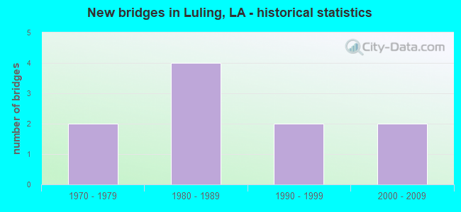
- New bridges - historical statistics
- 21970-1979
- 41980-1989
- 21990-1999
- 22000-2009


- Bridge Condition - Deck
- 25.0%Very good
- 50.0%Good
- 25.0%Satisfactory

- Bridge Condition - Superstructure
- 25.0%Very good
- 50.0%Good
- 25.0%Satisfactory

- Bridge Condition - Substructure
- 37.5%Very good
- 50.0%Good
- 12.5%Fair

- Bridge Condition - Channel
- 11.1%Very good
- 22.2%Good
- 66.7%Satisfactory

- Bridge Condition - Culverts
- 50.0%Good
- 50.0%Satisfactory
Find on map >> Show street view
Structure Number: 24500000020394, Location: 0.8 MILES SOUTH OF HALES (Lat: 29.924469, Lng: -90.392200), Route carried "on" structure: Interstate 310, Year Built: 1984, Status: Open, Structure Length: 0.91m (2.99ft), Average Daily Traffic: 40,300 (year 2016), Truck Traffic: 25%, Average Future Daily Traffic: 70,550 (year 2036), Design Load: HS 20, Features Intersected: DRAIN CANAL
Minimum Vertical Clearance: 30+ m (98+ ft), Kilometerpoint: 2.142, Lanes on structure: 4, Base Highway Network: Yes (Inventory Route: 450-38-1, Subroute: 10), Owner: State Highway Agency, Approaching Roadway Width: 10.7m (35.1ft), Skew: 30 degrees, Material/Design: Concrete, Design/Construction: Culvert, Number Of Spans In Main Unit: 1, Length of Maximum Span: 9.1m (29.9ft), Curb-To-Curb Width: 10.7m (35.1ft), Out-to-Out Width: 64.0m (210.0ft)
Condition: Channel: Good, Culverts: Satisfactory, Operating Rating: 42.1 metric tons, Method Used To Determine Operating Rating: Load and Resistance Factor Rating (LRFR) rating reported by rating factor(RF) method using HL-93 loadings, Inventory Rating: 32.4 metric tons, Method Used To Determine Inventory Rating: Load and Resistance Factor Rating (LRFR) rating reported by rating factor(RF) method using HL-93 loadings, Structural Evaluation: Equal to present minimum criteria, Deck Geometry: High priority of replacement, Waterway Adequacy: Better than present minimum criteria, Approach Roadway Alignment: Equal to present desirable criteria, Length Of Structure Improvement: 1.55m (5.09ft), Designated Inspection Frequency: Every 24 months, Inspection Date: March 2021, Bridge Improvement Cost: $132,000, Total Project Cost: $198,000 ( Estimate for 2016)
Find on map >> Show street view
Structure Number: 24500000020397, Location: 1 MILE WEST OF DAVIS POND (Lat: 29.917039, Lng: -90.319600), Route carried "on" structure: US 90, Year Built: 1999, Status: Open, Structure Length: 1.40m (4.59ft), Average Daily Traffic: 23,700 (year 2016), Truck Traffic: 10%, Average Future Daily Traffic: 39,440 (year 2036), Design Load: HS 20, Features Intersected: DRAIN DITCH
Minimum Vertical Clearance: 30+ m (98+ ft), Kilometerpoint: 7.220, Lanes on structure: 4, Base Highway Network: Yes (Inventory Route: 5-09-1, Subroute: 10), Owner: State Highway Agency, Approaching Roadway Width: 6.4m (21.0ft), Skew: 30 degrees, Material/Design: Concrete, Design/Construction: Culvert, Number Of Spans In Main Unit: 1, Length of Maximum Span: 14.0m (45.9ft), Curb-To-Curb Width: 24.4m (80.1ft), Out-to-Out Width: 60.0m (196.9ft)
Condition: Channel: Satisfactory, Culverts: Good, Operating Rating: 42.1 metric tons, Method Used To Determine Operating Rating: Load and Resistance Factor Rating (LRFR) rating reported by rating factor(RF) method using HL-93 loadings, Inventory Rating: 32.4 metric tons, Method Used To Determine Inventory Rating: Load and Resistance Factor Rating (LRFR) rating reported by rating factor(RF) method using HL-93 loadings, Structural Evaluation: Better than present minimum criteria, Deck Geometry: Superior to present desirable criteria, Waterway Adequacy: Equal to present minimum criteria, Approach Roadway Alignment: Equal to present desirable criteria, Designated Inspection Frequency: Every 24 months, Inspection Date: March 2021
Find on map >> Show street view
Structure Number: 24500000020512, Location: 2.0 MI. S. OF US 90 (Lat: 29.903769, Lng: -90.363131), Route carried "on" structure: County highway , Year Built: 2009, Status: Open, Structure Length: 0.70m (2.30ft), Design Load: HS 20, Features Intersected: ELLINGTON CANAL, Facility Carried by Structure: Maryland Dr
Minimum Vertical Clearance: 30+ m (98+ ft), Kilometerpoint: 0.000, Lanes on structure: 2, Owner: County Highway Agency, Approaching Roadway Width: 6.1m (20.0ft), Skew: 30 degrees, Material/Design: Concrete, Design/Construction: Arch - Deck, Number Of Spans In Main Unit: 1, Length of Maximum Span: 7.0m (23.0ft), Curb-To-Curb Width: 6.4m (21.0ft), Out-to-Out Width: 9.8m (32.2ft)
Condition: Deck: Very good, Superstructure: Very good, Substructure: Good, Channel: Good, Operating Rating: 52.2 metric tons, Method Used To Determine Operating Rating: Load and Resistance Factor Rating (LRFR) rating reported by rating factor(RF) method using HL-93 loadings, Inventory Rating: 40.2 metric tons, Method Used To Determine Inventory Rating: Load and Resistance Factor Rating (LRFR) rating reported by rating factor(RF) method using HL-93 loadings, Structural Evaluation: Better than present minimum criteria, Deck Geometry: Somewhat better than minimum adequacy, Waterway Adequacy: Better than present minimum criteria, Approach Roadway Alignment: Equal to present desirable criteria, Designated Inspection Frequency: Every 24 months, Inspection Date: June 2021, Deck Structure Type: Concrete Cast-file-Place, Wearing Surface/Protective System: Wearing Surface: Bituminous
Find on map >> Show street view
Structure Number: 24500050904651, Location: 3.0 MI EAST OF LA 632 (Lat: 29.916939, Lng: -90.317900), Route carried "on" structure: US 90, Year Built: 2002, Status: Open, Structure Length: 10.79m (35.40ft), Average Daily Traffic: 11,850 (year 2016), Truck Traffic: 10%, Average Future Daily Traffic: 23,664 (year 2036), Design Load: HS 20, Features Intersected: DAVIS POND DIVERSION
Minimum Vertical Clearance: 30+ m (98+ ft), Kilometerpoint: 7.382, Lanes on structure: 2, Base Highway Network: Yes (Inventory Route: 5-09-1, Subroute: 10), Owner: State Highway Agency, Approaching Roadway Width: 12.2m (40.0ft), Skew: 31 degrees, Material/Design: Prestressed concrete, Design/Construction: Stringer/Multi-beam, Number Of Spans In Main Unit: 6, Length of Maximum Span: 18.0m (59.1ft), Curb-To-Curb Width: 12.2m (40.0ft), Out-to-Out Width: 13.7m (44.9ft)
Condition: Deck: Very good, Superstructure: Very good, Substructure: Very good, Channel: Very good, Operating Rating: 42.1 metric tons, Method Used To Determine Operating Rating: Load and Resistance Factor Rating (LRFR) rating reported by rating factor(RF) method using HL-93 loadings, Inventory Rating: 32.4 metric tons, Method Used To Determine Inventory Rating: Load and Resistance Factor Rating (LRFR) rating reported by rating factor(RF) method using HL-93 loadings, Structural Evaluation: Equal to present desirable criteria, Deck Geometry: Better than present minimum criteria, Waterway Adequacy: Equal to present desirable criteria, Approach Roadway Alignment: Equal to present desirable criteria, Designated Inspection Frequency: Every 24 months, Underwater Inspection Frequency: Every 60 months, Inspection Date: September 2020, Underwater Inspection Date: January 2021, Deck Structure Type: Concrete Cast-file-Place
Find on map >> Show street view
Structure Number: 24504280310131, Location: 2.2 MI EAST OF LA 3160 (Lat: 29.926281, Lng: -90.418300), Route carried "on" structure: State highway 3127, Year Built: 1975, Status: Open, Structure Length: 2.44m (8.01ft), Average Daily Traffic: 5,100 (year 2016), Truck Traffic: 20%, Average Future Daily Traffic: 14,484 (year 2036), Design Load: HS 20, Features Intersected: HYMEL CANAL
Minimum Vertical Clearance: 30+ m (98+ ft), Kilometerpoint: 15.512, Lanes on structure: 2, Base Highway Network: Yes (Inventory Route: 428-03-1, Subroute: 10), Owner: State Highway Agency, Approaching Roadway Width: 15.2m (49.9ft), Skew: 11 degrees, Material/Design: Concrete, Design/Construction: Slab, Number Of Spans In Main Unit: 4, Length of Maximum Span: 6.1m (20.0ft), Curb-To-Curb Width: 12.2m (40.0ft), Out-to-Out Width: 13.2m (43.3ft)
Condition: Deck: Good, Superstructure: Good, Substructure: Very good, Channel: Satisfactory, Operating Rating: 71.7 metric tons, Method Used To Determine Operating Rating: Load Factor (LF), Inventory Rating: 43.5 metric tons, Method Used To Determine Inventory Rating: Load Factor (LF), Structural Evaluation: Better than present minimum criteria, Deck Geometry: Better than present minimum criteria, Waterway Adequacy: Better than present minimum criteria, Approach Roadway Alignment: Equal to present desirable criteria, Designated Inspection Frequency: Every 24 months, Underwater Inspection Frequency: Every 60 months, Inspection Date: April 2020, Underwater Inspection Date: September 2020, Deck Structure Type: Concrete Cast-file-Place
Find on map >> Show street view
Structure Number: 24504280310132, Location: 2.2 MI EAST OF LA 3160 (Lat: 29.926181, Lng: -90.417900), Route carried "on" structure: State highway 3127, Year Built: 1990, Status: Open, Structure Length: 2.44m (8.01ft), Average Daily Traffic: 5,100 (year 2016), Truck Traffic: 20%, Average Future Daily Traffic: 14,484 (year 2036), Design Load: HS 20, Features Intersected: HYMEL CANAL
Minimum Vertical Clearance: 30+ m (98+ ft), Kilometerpoint: 2.000, Lanes on structure: 2, Base Highway Network: Yes (Inventory Route: 428-03-2, Subroute: 10), Owner: State Highway Agency, Approaching Roadway Width: 12.2m (40.0ft), Skew: 17 degrees, Material/Design: Concrete, Design/Construction: Slab, Number Of Spans In Main Unit: 4, Length of Maximum Span: 6.1m (20.0ft), Curb-To-Curb Width: 12.2m (40.0ft), Out-to-Out Width: 13.0m (42.7ft)
Condition: Deck: Good, Superstructure: Good, Substructure: Very good, Channel: Satisfactory, Operating Rating: 72.6 metric tons, Method Used To Determine Operating Rating: Load Factor (LF), Inventory Rating: 43.5 metric tons, Method Used To Determine Inventory Rating: Load Factor (LF), Structural Evaluation: Better than present minimum criteria, Deck Geometry: Better than present minimum criteria, Waterway Adequacy: Better than present minimum criteria, Approach Roadway Alignment: Equal to present desirable criteria, Designated Inspection Frequency: Every 24 months, Inspection Date: April 2020, Deck Structure Type: Concrete Cast-file-Place
Find on map >> Show street view
Structure Number: 24504280310815, Location: 2.9 MI EAST OF LA 3160 (Lat: 29.917550, Lng: -90.414000), Route carried "on" structure: Ramp Interstate 310, Year Built: 1986, Status: Open, Structure Length: 100.58m (329.99ft), Average Daily Traffic: 4,310 (year 2016), Truck Traffic: 25%, Average Future Daily Traffic: 7,293 (year 2036), Design Load: HS 20, Features Intersected: LA 3127 & I-310
Minimum Vertical Clearance: 30+ m (98+ ft), Kilometerpoint: 0.420, Lanes on structure: 1, Lanes under structure: 8, Owner: State Highway Agency, Approaching Roadway Width: 7.6m (24.9ft), Skew: 4 degrees, Material/Design: Steel continuous, Design/Construction: Girder and Floorbeam System, Number Of Spans In Main Unit: 2, Number Of Approach Spans: 46, Length of Maximum Span: 62.5m (205.1ft), Curb-To-Curb Width: 7.6m (24.9ft), Out-to-Out Width: 8.5m (27.9ft)
Condition: Deck: Satisfactory, Superstructure: Satisfactory, Substructure: Fair, Operating Rating: 20.7 metric tons, Method Used To Determine Operating Rating: Load and Resistance Factor Rating (LRFR) rating reported by rating factor(RF) method using HL-93 loadings, Inventory Rating: 15.9 metric tons, Method Used To Determine Inventory Rating: Load and Resistance Factor Rating (LRFR) rating reported by rating factor(RF) method using HL-93 loadings, Structural Evaluation: High priority of replacement, Deck Geometry: Better than present minimum criteria, Underclear: Equal to present minimum criteria, Approach Roadway Alignment: Equal to present desirable criteria, Length Of Structure Improvement: 100.58m (329.99ft), Designated Inspection Frequency: Every 24 months, Inspection Date: September 2021, Bridge Improvement Cost: $8,580,000, Total Project Cost: $12,870,000 ( Estimate for 2016), Deck Structure Type: Concrete Cast-file-Place
Find on map >> Show street view
Structure Number: 24504280311571, Location: 3.6 MI EAST OF LA 3160 (Lat: 29.908800, Lng: -90.408500), Route carried "on" structure: State highway 3127, Year Built: 1975, Status: Open, Structure Length: 3.05m (10.01ft), Average Daily Traffic: 5,100 (year 2016), Truck Traffic: 20%, Average Future Daily Traffic: 14,484 (year 2036), Design Load: HS 20, Features Intersected: EIGHTY ARPENT CANAL
Minimum Vertical Clearance: 30+ m (98+ ft), Kilometerpoint: 17.671, Lanes on structure: 2, Base Highway Network: Yes (Inventory Route: 428-03-1, Subroute: 10), Owner: State Highway Agency, Approaching Roadway Width: 15.2m (49.9ft), Skew: 10 degrees, Material/Design: Concrete, Design/Construction: Slab, Number Of Spans In Main Unit: 5, Length of Maximum Span: 6.1m (20.0ft), Curb-To-Curb Width: 12.2m (40.0ft), Out-to-Out Width: 13.2m (43.3ft)
Condition: Deck: Satisfactory, Superstructure: Satisfactory, Substructure: Good, Channel: Satisfactory, Operating Rating: 71.7 metric tons, Method Used To Determine Operating Rating: Load Factor (LF), Inventory Rating: 43.5 metric tons, Method Used To Determine Inventory Rating: Load Factor (LF), Structural Evaluation: Equal to present minimum criteria, Deck Geometry: Better than present minimum criteria, Waterway Adequacy: Equal to present desirable criteria, Approach Roadway Alignment: Equal to present desirable criteria, Designated Inspection Frequency: Every 24 months, Underwater Inspection Frequency: Every 60 months, Inspection Date: April 2020, Underwater Inspection Date: December 2018, Deck Structure Type: Concrete Cast-file-Place
Find on map >> Show street view
Structure Number: 24529540902101, Location: 0.3 MI SOUTH OF US 90 (Lat: 29.902589, Lng: -90.352719), Route carried "on" structure: County highway , Year Built: 1988, Status: Open, Structure Length: 1.16m (3.81ft), Design Load: HS 20, Features Intersected: COUSIN'S CANAL, Facility Carried by Structure: W HEATHER DR
Minimum Vertical Clearance: 30+ m (98+ ft), Kilometerpoint: 0.000, Lanes on structure: 2, Owner: County Highway Agency, Approaching Roadway Width: 7.3m (24.0ft), Material/Design: Concrete, Design/Construction: Slab, Number Of Spans In Main Unit: 2, Length of Maximum Span: 5.8m (19.0ft), Curb-To-Curb Width: 7.9m (25.9ft), Out-to-Out Width: 8.2m (26.9ft)
Condition: Deck: Good, Superstructure: Good, Substructure: Good, Channel: Satisfactory, Operating Rating: 28.2 metric tons, Method Used To Determine Operating Rating: Load and Resistance Factor Rating (LRFR) rating reported by rating factor(RF) method using HL-93 loadings, Inventory Rating: 21.7 metric tons, Method Used To Determine Inventory Rating: Load and Resistance Factor Rating (LRFR) rating reported by rating factor(RF) method using HL-93 loadings, Structural Evaluation: Equal to present minimum criteria, Deck Geometry: Equal to present minimum criteria, Waterway Adequacy: Equal to present minimum criteria, Approach Roadway Alignment: Equal to present desirable criteria, Designated Inspection Frequency: Every 24 months, Inspection Date: June 2021, Deck Structure Type: Concrete Precast Panels, Wearing Surface/Protective System: Wearing Surface: Monolithic Concrete
Find on map >> Show street view
Structure Number: 24529540902181, Location: 0.7 MI SOUTH OF US 90 (Lat: 29.908639, Lng: -90.350581), Route carried "on" structure: County highway , Year Built: 1988, Status: Open, Structure Length: 1.16m (3.81ft), Design Load: HS 20, Features Intersected: COUSIN'S CANAL, Facility Carried by Structure: BIRCH ST
Minimum Vertical Clearance: 30+ m (98+ ft), Kilometerpoint: 0.000, Lanes on structure: 2, Owner: County Highway Agency, Approaching Roadway Width: 8.2m (26.9ft), Material/Design: Concrete, Design/Construction: Slab, Number Of Spans In Main Unit: 2, Length of Maximum Span: 5.8m (19.0ft), Curb-To-Curb Width: 7.8m (25.6ft), Out-to-Out Width: 8.2m (26.9ft)
Condition: Deck: Good, Superstructure: Good, Substructure: Good, Channel: Satisfactory, Operating Rating: 28.2 metric tons, Method Used To Determine Operating Rating: Load and Resistance Factor Rating (LRFR) rating reported by rating factor(RF) method using HL-93 loadings, Inventory Rating: 21.7 metric tons, Method Used To Determine Inventory Rating: Load and Resistance Factor Rating (LRFR) rating reported by rating factor(RF) method using HL-93 loadings, Structural Evaluation: Equal to present minimum criteria, Deck Geometry: Equal to present minimum criteria, Waterway Adequacy: Equal to present minimum criteria, Approach Roadway Alignment: Equal to present desirable criteria, Designated Inspection Frequency: Every 24 months, Inspection Date: June 2021, Deck Structure Type: Concrete Precast Panels, Wearing Surface/Protective System: Wearing Surface: Monolithic Concrete
Find on map >> Show street view
Structure Number: 24504280310815, Location: I-310 RAMP AT LA 3127 (Lat: 29.916300, Lng: -90.412731), Route carried "under" structure: Ramp State highway 3127, Structure Length: 0. m, Average Daily Traffic: 5,100 (year 2014), Features Intersected: LA 3127 SB OFF RAMP TO I
Minimum Vertical Clearance: 5.40m (17.72ft), Kilometerpoint: 16.744, Lanes on structure: 1, Lanes under structure: 2, Length of Maximum Span: 0.0m
Find on map >> Show street view
Structure Number: 24504280310815, Location: I-310 RAMP AT LA 3127 (Lat: 29.915889, Lng: -90.411531), Route carried "under" structure: Ramp State highway 3127, Structure Length: 0. m, Average Daily Traffic: 5,100 (year 2014), Features Intersected: LA 3127 SB OFF RAMP TO I
Minimum Vertical Clearance: 8.02m (26.31ft), Kilometerpoint: 0.698, Lanes on structure: 1, Lanes under structure: 2, Length of Maximum Span: 0.0m
Find on map >> Show street view
Structure Number: 24504280310815, Location: I-310 RAMP AT LA 3127 (Lat: 29.916169, Lng: -90.406669), Route carried "under" structure: Interstate 310, Structure Length: 0. m, Average Daily Traffic: 4,290 (year 2015), Features Intersected: I-310 SB UNDER 3127 NB O
Minimum Vertical Clearance: 7.38m (24.21ft), Kilometerpoint: 3.827, Lanes on structure: 1, Lanes under structure: 2, Length of Maximum Span: 0.0m
Find on map >> Show street view
Structure Number: 24504280310815, Location: I-310 RAMP AT LA 3127 (Lat: 29.916281, Lng: -90.406061), Route carried "under" structure: Interstate 310, Structure Length: 0. m, Average Daily Traffic: 4,290 (year 2015), Features Intersected: I-310 NB UNDER 3127 NB O
Minimum Vertical Clearance: 5.58m (18.31ft), Kilometerpoint: 2.918, Lanes on structure: 1, Lanes under structure: 2, Length of Maximum Span: 0.0m
Find on map >> Show street view
Structure Number: 24504503700001, Location: 3.25 MI E OF 3160 (Lat: 29.938131, Lng: -90.376711), Route carried "under" structure: State highway 18, Structure Length: 0. m, Average Daily Traffic: 2,400 (year 2014), Features Intersected: LA 18 EB UNDER I-310
Minimum Vertical Clearance: 30+ m (98+ ft), Kilometerpoint: 17.463, Lanes on structure: 4, Lanes under structure: 2, Length of Maximum Span: 0.0m
Find on map >> Show street view
Structure Number: 24504503700001, Location: 0.7 MI W OF LA 52 (Lat: 29.938150, Lng: -90.376400), Route carried "under" structure: State highway 18, Structure Length: 0. m, Average Daily Traffic: 2,400 (year 2014), Features Intersected: LA 18 WB UNDER I-310
Minimum Vertical Clearance: 30+ m (98+ ft), Kilometerpoint: 1.234, Lanes on structure: 4, Lanes under structure: 1, Length of Maximum Span: 0.0m
Find on map >> Show street view
Structure Number: 24504503800001, Location: I-310 @ LA 18 (Lat: 29.933161, Lng: -90.379169), Route carried "under" structure: Ramp Interstate 310, Structure Length: 0. m, Average Daily Traffic: 4,030 (year 2014), Features Intersected: I-310 SB ON RAMP FROM LA
Minimum Vertical Clearance: 15.91m (52.20ft), Kilometerpoint: 0.716, Lanes on structure: 4, Lanes under structure: 1, Length of Maximum Span: 0.0m
Find on map >> Show street view
Structure Number: 24504503800207, Location: I-310 @ LA 18 (Lat: 29.932861, Lng: -90.380389), Route carried "under" structure: Ramp Interstate 310, Structure Length: 0. m, Average Daily Traffic: 4,030 (year 2014), Features Intersected: I-310 SB ON RAMP UNDER I
Minimum Vertical Clearance: 6.34m (20.80ft), Kilometerpoint: 0.459, Lanes on structure: 1, Lanes under structure: 1, Length of Maximum Span: 0.0m
Find on map >> Show street view
Structure Number: 24504503800361, Location: I-310 @ LA 18 (Lat: 29.932350, Lng: -90.380200), Route carried "under" structure: Ramp Interstate 310, Structure Length: 0. m, Average Daily Traffic: 4,030 (year 2014), Features Intersected: I-310 SB OFF RAMP UNDER
Minimum Vertical Clearance: 7.19m (23.59ft), Kilometerpoint: 0.531, Lanes on structure: 2, Lanes under structure: 1, Length of Maximum Span: 0.0m
Find on map >> Show street view
Structure Number: 24504503800362, Location: I-310 @ LA 18 (Lat: 29.932200, Lng: -90.380081), Route carried "under" structure: Ramp Interstate 310, Structure Length: 0. m, Average Daily Traffic: 4,030 (year 2014), Features Intersected: I-310 SB OFF RAMP UNDER
Minimum Vertical Clearance: 8.44m (27.69ft), Kilometerpoint: 0.549, Lanes on structure: 2, Lanes under structure: 1, Length of Maximum Span: 0.0m
Find on map >> Show street view
Structure Number: 24504503802411, Location: LA 3127 NB UNDER I-310 SB (Lat: 29.911561, Lng: -90.408319), Route carried "under" structure: State highway 3127, Structure Length: 0. m, Average Daily Traffic: 5,100 (year 2014), Features Intersected: LA 3127 NB UNDER I-310 S
Minimum Vertical Clearance: 5.46m (17.91ft), Kilometerpoint: 0.201, Lanes on structure: 2, Lanes under structure: 2, Length of Maximum Span: 0.0m