Bridge Statistics for Kahului, Hawaii (HI)
Condition, Traffic, Stress, Structural Evaluation, Project Costs
- National Bridge Inventory (NBI) Statistics
- 13Number of bridges
- 89ft / 27.1mTotal length
- $8,801,000Total costs
- 243,925Total average daily traffic
- 2,797Total average daily truck traffic
- 324,567Total future (year 2018) average daily traffic
- National Bridge Inventory (NBI) Registered Bridges for Kahului
- No street view available for this location
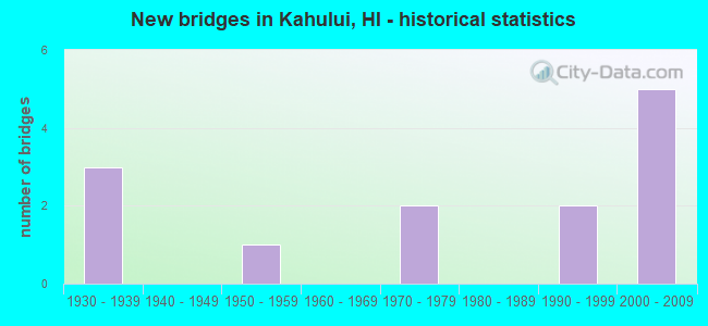
- New bridges - historical statistics
- 31930-1939
- 11950-1959
- 21970-1979
- 21990-1999
- 52000-2009


- Bridge Condition - Deck
- 33.3%Good
- 58.3%Satisfactory
- 8.3%Fair

- Bridge Condition - Superstructure
- 50.0%Good
- 41.7%Satisfactory
- 8.3%Fair

- Bridge Condition - Substructure
- 41.7%Good
- 50.0%Satisfactory
- 8.3%Fair

- Bridge Condition - Channel
- 9.1%Very good
- 45.5%Good
- 27.3%Satisfactory
- 18.2%Fair
Find on map >> Show street view
Structure Number: 900032040005, Location: 0.10MI E/KINIPOPO ST (Lat: 20.888694, Lng: -156.497392), Route carried "on" structure: US 32, Year Built: 1936, Status: Open, Structure Length: 2.41m (7.91ft), Average Daily Traffic: 24,700 (year 2017), Truck Traffic: 2%, Average Future Daily Traffic: 40,888 (year 2025), Design Load: H 15, Features Intersected: WAIALE DR, Facility Carried by Structure: KAAHUMANU AVE
Minimum Vertical Clearance: 30+ m (98+ ft), Kilometerpoint: 0.805, Lanes on structure: 3, Lanes under structure: 3, Base Highway Network: Yes, Owner: State Highway Agency, Approaching Roadway Width: 10.4m (34.1ft), Skew: 3 degrees, Material/Design: Steel, Design/Construction: Stringer/Multi-beam, Number Of Spans In Main Unit: 2, Length of Maximum Span: 15.5m (50.9ft), Curb or Sidewalk Widths: Left: 0.0m, Right: 1.2m (3.9ft), Curb-To-Curb Width: 10.4m (34.1ft), Out-to-Out Width: 15.1m (49.5ft)
Condition: Deck: Satisfactory, Superstructure: Good, Substructure: Satisfactory, Operating Rating: 32.1 metric tons, Method Used To Determine Operating Rating: Load and Resistance Factor Rating (LRFR) rating reported by rating factor(RF) method using HL-93 loadings, Inventory Rating: 24.6 metric tons, Method Used To Determine Inventory Rating: Load and Resistance Factor Rating (LRFR) rating reported by rating factor(RF) method using HL-93 loadings, Structural Evaluation: Equal to present minimum criteria, Deck Geometry: High priority of replacement, Underclear: Meets minimum limits, Approach Roadway Alignment: Equal to present minimum criteria, Length Of Structure Improvement: 3.14m (10.30ft), Designated Inspection Frequency: Every 24 months, Inspection Date: August 2020, Total Project Cost: $3,974,000, Deck Structure Type: Concrete Cast-file-Place, Wearing Surface/Protective System: Wearing Surface: Bituminous
Find on map >> Show street view
Structure Number: 900032120006, Location: 0.06MI W/AKU PL (Lat: 20.888853, Lng: -156.496017), Route carried "on" structure: City street 32, Year Built: 1936, Status: Open, Structure Length: 1.92m (6.30ft), Average Daily Traffic: 24,700 (year 2017), Truck Traffic: 2%, Average Future Daily Traffic: 40,888 (year 2025), Design Load: H 15, Features Intersected: KAAHUMANU AVE, Facility Carried by Structure: NANILOA DR
Minimum Vertical Clearance: 4.52m (14.83ft), Kilometerpoint: 0.966, Lanes on structure: 2, Lanes under structure: 3, Owner: State Highway Agency, Approaching Roadway Width: 9.1m (29.9ft), Material/Design: Concrete continuous, Design/Construction: Frame, Number Of Spans In Main Unit: 1, Length of Maximum Span: 15.5m (50.9ft), Curb or Sidewalk Widths: Left: 0.8m (2.6ft), Right: 0.8m (2.6ft), Curb-To-Curb Width: 6.1m (20.0ft), Out-to-Out Width: 8.2m (26.9ft)
Condition: Deck: Fair, Superstructure: Fair, Substructure: Fair, Operating Rating: 81.3 metric tons, Method Used To Determine Operating Rating: Load and Resistance Factor Rating (LRFR) rating reported by rating factor(RF) method using HL-93 loadings, Inventory Rating: 62.5 metric tons, Method Used To Determine Inventory Rating: Load and Resistance Factor Rating (LRFR) rating reported by rating factor(RF) method using HL-93 loadings, Structural Evaluation: Somewhat better than minimum adequacy, Underclear: Meets minimum limits, Approach Roadway Alignment: Somewhat better than minimum adequacy, Length Of Structure Improvement: 2.62m (8.60ft), Designated Inspection Frequency: Every 24 months, Inspection Date: August 2020, Total Project Cost: $2,368,000, Deck Structure Type: Concrete Cast-file-Place
Find on map >> Show street view
Structure Number: 9000370300759, Location: 0.95MI N/CROSS RD (Lat: 20.720186, Lng: -156.345300), Route carried "on" structure: US 37, Year Built: 1933, Status: Open, Structure Length: 0.76m (2.49ft), Average Daily Traffic: 2,000 (year 2017), Truck Traffic: 4%, Average Future Daily Traffic: 2,668 (year 2025), Design Load: H 15, Features Intersected: WAIOHULI "B" STRM, Facility Carried by Structure: KULA HWY
Minimum Vertical Clearance: 30+ m (98+ ft), Kilometerpoint: 24.880, Lanes on structure: 2, Base Highway Network: Yes, Owner: State Highway Agency, Approaching Roadway Width: 7.9m (25.9ft), Skew: 4 degrees, Material/Design: Concrete, Design/Construction: Tee Beam, Number Of Spans In Main Unit: 1, Length of Maximum Span: 7.3m (24.0ft), Curb-To-Curb Width: 6.7m (22.0ft), Out-to-Out Width: 7.6m (24.9ft)
Condition: Deck: Satisfactory, Superstructure: Satisfactory, Substructure: Satisfactory, Channel: Satisfactory, Operating Rating: 33.0 metric tons, Method Used To Determine Operating Rating: Load and Resistance Factor Rating (LRFR) rating reported by rating factor(RF) method using HL-93 loadings, Inventory Rating: 25.6 metric tons, Method Used To Determine Inventory Rating: Load and Resistance Factor Rating (LRFR) rating reported by rating factor(RF) method using HL-93 loadings, Structural Evaluation: Equal to present minimum criteria, Deck Geometry: High priority of corrective action, Waterway Adequacy: Somewhat better than minimum adequacy, Approach Roadway Alignment: Meets minimum limits, Designated Inspection Frequency: Every 24 months, Inspection Date: December 2020, Total Project Cost: $370,000, Deck Structure Type: Concrete Cast-file-Place
Find on map >> Show street view
Structure Number: 9000370301975, Location: Haleakala Hwy/Keahua Chrd (Lat: 20.837778, Lng: -156.465000), Route carried "on" structure: US 37, Year Built: 2007, Status: Open, Structure Length: 1.68m (5.51ft), Average Daily Traffic: 32,700 (year 2017), Average Future Daily Traffic: 35,900 (year 2018), Design Load: HS 20, Features Intersected: Lowrie Ditch, Facility Carried by Structure: Haleakala Hwy
Minimum Vertical Clearance: 30+ m (98+ ft), Kilometerpoint: 5.261, Lanes on structure: 2, Base Highway Network: Yes, Owner: State Highway Agency, Approaching Roadway Width: 11.6m (38.1ft), Skew: 1 degrees, Material/Design: Prestressed concrete, Design/Construction: Slab, Number Of Spans In Main Unit: 1, Length of Maximum Span: 12.2m (40.0ft), Curb-To-Curb Width: 11.6m (38.1ft), Out-to-Out Width: 12.5m (41.0ft)
Condition: Deck: Satisfactory, Superstructure: Good, Substructure: Good, Channel: Good, Operating Rating: 97.2 metric tons, Method Used To Determine Operating Rating: Load and Resistance Factor Rating (LRFR) rating reported by rating factor(RF) method using HL-93 loadings, Inventory Rating: 89.1 metric tons, Method Used To Determine Inventory Rating: Load and Resistance Factor Rating (LRFR) rating reported by rating factor(RF) method using HL-93 loadings, Structural Evaluation: Better than present minimum criteria, Deck Geometry: Better than present minimum criteria, Waterway Adequacy: Equal to present minimum criteria, Approach Roadway Alignment: Better than present minimum criteria, Designated Inspection Frequency: Every 24 months, Inspection Date: January 2021, Deck Structure Type: Concrete Cast-file-Place
Find on map >> Show street view
Structure Number: 9000370600169, Location: 1.73mi E of Hana Highway (Lat: 20.877464, Lng: -156.402275), Route carried "on" structure: US 37, Year Built: 2007, Status: Open, Structure Length: 1.25m (4.10ft), Average Daily Traffic: 33,100 (year 2019), Average Future Daily Traffic: 41,000 (year 2039), Features Intersected: Haiku Ditch, Facility Carried by Structure: HALEAKALA HIGHWAY
Minimum Vertical Clearance: 30+ m (98+ ft), Kilometerpoint: 2.720, Lanes on structure: 2, Owner: State Highway Agency, Approaching Roadway Width: 11.6m (38.1ft), Skew: 3 degrees, Material/Design: Prestressed concrete, Design/Construction: Slab, Number Of Spans In Main Unit: 1, Length of Maximum Span: 8.5m (27.9ft), Curb-To-Curb Width: 11.6m (38.1ft), Out-to-Out Width: 12.5m (41.0ft)
Condition: Deck: Good, Superstructure: Good, Substructure: Good, Channel: Satisfactory, Operating Rating: 97.2 metric tons, Method Used To Determine Operating Rating: Load and Resistance Factor Rating (LRFR) rating reported by rating factor(RF) method using HL-93 loadings, Inventory Rating: 73.2 metric tons, Method Used To Determine Inventory Rating: Load and Resistance Factor Rating (LRFR) rating reported by rating factor(RF) method using HL-93 loadings, Structural Evaluation: Better than present minimum criteria, Deck Geometry: Somewhat better than minimum adequacy, Waterway Adequacy: Equal to present minimum criteria, Approach Roadway Alignment: Equal to present minimum criteria, Designated Inspection Frequency: Every 24 months, Inspection Date: October 2021, Deck Structure Type: Concrete Cast-file-Place
Find on map >> Show street view
Structure Number: 9000370600247, Location: 2.48mi E of Hana Highway (Lat: 20.871453, Lng: -156.392136), Route carried "on" structure: US 37, Year Built: 2007, Status: Open, Structure Length: 1.07m (3.51ft), Average Daily Traffic: 33,100 (year 2019), Average Future Daily Traffic: 41,000 (year 2039), Features Intersected: Reservoir 52 Ditch, Facility Carried by Structure: HALEAKALA HIGHWAY
Minimum Vertical Clearance: 30+ m (98+ ft), Kilometerpoint: 3.975, Lanes on structure: 2, Owner: State Highway Agency, Approaching Roadway Width: 11.6m (38.1ft), Material/Design: Prestressed concrete, Design/Construction: Slab, Number Of Spans In Main Unit: 1, Length of Maximum Span: 6.7m (22.0ft), Curb-To-Curb Width: 11.6m (38.1ft), Out-to-Out Width: 12.5m (41.0ft)
Condition: Deck: Good, Superstructure: Good, Substructure: Good, Channel: Satisfactory, Operating Rating: 97.2 metric tons, Method Used To Determine Operating Rating: Load and Resistance Factor Rating (LRFR) rating reported by rating factor(RF) method using HL-93 loadings, Inventory Rating: 60.6 metric tons, Method Used To Determine Inventory Rating: Load and Resistance Factor Rating (LRFR) rating reported by rating factor(RF) method using HL-93 loadings, Structural Evaluation: Better than present minimum criteria, Deck Geometry: Somewhat better than minimum adequacy, Waterway Adequacy: Equal to present minimum criteria, Approach Roadway Alignment: Equal to present minimum criteria, Designated Inspection Frequency: Every 24 months, Inspection Date: October 2021, Deck Structure Type: Concrete Cast-file-Place
Find on map >> Show street view
Structure Number: 9000371100001, Location: .2MI. E. AALELE RD. (Lat: 20.887597, Lng: -156.435094), Route carried "on" structure: County highway 396, Year Built: 1990, Status: Open, Structure Length: 3.17m (10.40ft), Average Daily Traffic: 1,800 (year 1980), Average Future Daily Traffic: 2,250 (year 2025), Design Load: HS 20, Features Intersected: KALIALINUI STRM, Facility Carried by Structure: HALEAKALA HWY
Minimum Vertical Clearance: 30+ m (98+ ft), Kilometerpoint: 0.000, Lanes on structure: 2, Owner: County Highway Agency, Approaching Roadway Width: 17.1m (56.1ft), Skew: 1 degrees, Material/Design: Prestressed concrete, Design/Construction: Stringer/Multi-beam, Number Of Spans In Main Unit: 1, Length of Maximum Span: 29.2m (95.8ft), Curb-To-Curb Width: 17.1m (56.1ft), Out-to-Out Width: 18.0m (59.1ft)
Condition: Deck: Good, Superstructure: Good, Substructure: Good, Channel: Very good, Operating Rating: 26.2 metric tons, Method Used To Determine Operating Rating: Load and Resistance Factor Rating (LRFR) rating reported by rating factor(RF) method using HL-93 loadings, Inventory Rating: 20.4 metric tons, Method Used To Determine Inventory Rating: Load and Resistance Factor Rating (LRFR) rating reported by rating factor(RF) method using HL-93 loadings, Structural Evaluation: Somewhat better than minimum adequacy, Deck Geometry: Superior to present desirable criteria, Approach Roadway Alignment: Somewhat better than minimum adequacy, Length Of Structure Improvement: 3.17m (10.40ft), Designated Inspection Frequency: Every 24 months, Inspection Date: September 2020, Roadway Improvement Cost: $59,000, Total Project Cost: $892,000, Deck Structure Type: Concrete Cast-file-Place, Wearing Surface/Protective System: Wearing Surface: Monolithic Concrete
Find on map >> Show street view
Structure Number: 9003110300275, Location: .54 S Waiko Rd (Lat: 20.837700, Lng: -156.464772), Route carried "on" structure: US 311, Year Built: 2005, Status: Open, Structure Length: 3.66m (12.01ft), Average Daily Traffic: 34,300 (year 2017), Average Future Daily Traffic: 40,200 (year 2027), Design Load: HS 20, Features Intersected: Pulehu Stream
Minimum Vertical Clearance: 0.00m, Kilometerpoint: 4.425, Lanes on structure: 4, Owner: State Highway Agency, Approaching Roadway Width: 32.5m (106.6ft), Material/Design: Concrete, Design/Construction: Culvert, Number Of Spans In Main Unit: 10, Length of Maximum Span: 3.7m (12.1ft), Curb-To-Curb Width: 32.5m (106.6ft), Out-to-Out Width: 33.2m (108.9ft)
Condition: Channel: Good, Culverts: Satisfactory, Operating Rating: 97.2 metric tons, Method Used To Determine Operating Rating: Load and Resistance Factor Rating (LRFR) rating reported by rating factor(RF) method using HL-93 loadings, Inventory Rating: 78.1 metric tons, Method Used To Determine Inventory Rating: Load and Resistance Factor Rating (LRFR) rating reported by rating factor(RF) method using HL-93 loadings, Structural Evaluation: Equal to present minimum criteria, Deck Geometry: Superior to present desirable criteria, Waterway Adequacy: Somewhat better than minimum adequacy, Approach Roadway Alignment: Equal to present desirable criteria, Designated Inspection Frequency: Every 24 months, Inspection Date: Febuary 2021, Deck Structure Type: Concrete Precast Panels, Wearing Surface/Protective System: Wearing Surface: Wood or Timber
Find on map >> Show street view
Structure Number: 9003800500062, Location: 0.62MI E/HONOAPIILANI HWY (Lat: 20.821944, Lng: -156.499431), Route carried "on" structure: US 380, Year Built: 1970, Status: Open, Structure Length: 1.13m (3.71ft), Average Daily Traffic: 14,645 (year 2007), Truck Traffic: 5%, Average Future Daily Traffic: 17,124 (year 2025), Design Load: HS 20, Features Intersected: PALEAAHU GULCH, Facility Carried by Structure: KUIHELANI HWY
Minimum Vertical Clearance: 30+ m (98+ ft), Kilometerpoint: 10.089, Lanes on structure: 2, Base Highway Network: Yes, Owner: State Highway Agency, Approaching Roadway Width: 13.4m (44.0ft), Material/Design: Concrete, Design/Construction: Slab, Number Of Spans In Main Unit: 1, Length of Maximum Span: 10.7m (35.1ft), Curb-To-Curb Width: 13.4m (44.0ft), Out-to-Out Width: 14.4m (47.2ft)
Condition: Deck: Satisfactory, Superstructure: Satisfactory, Substructure: Satisfactory, Channel: Fair, Operating Rating: 37.6 metric tons, Method Used To Determine Operating Rating: Load and Resistance Factor Rating (LRFR) rating reported by rating factor(RF) method using HL-93 loadings, Inventory Rating: 29.2 metric tons, Method Used To Determine Inventory Rating: Load and Resistance Factor Rating (LRFR) rating reported by rating factor(RF) method using HL-93 loadings, Structural Evaluation: Equal to present minimum criteria, Deck Geometry: Superior to present desirable criteria, Waterway Adequacy: Somewhat better than minimum adequacy, Approach Roadway Alignment: Equal to present desirable criteria, Designated Inspection Frequency: Every 24 months, Inspection Date: March 2021, Deck Structure Type: Concrete Cast-file-Place
Find on map >> Show street view
Structure Number: 9003800500306, Location: 3.06MI E/HONOAPIILANI HWY (Lat: 20.853072, Lng: -156.482369), Route carried "on" structure: US 380, Year Built: 1970, Status: Open, Structure Length: 0.73m (2.40ft), Average Daily Traffic: 16,100 (year 2017), Truck Traffic: 5%, Average Future Daily Traffic: 17,124 (year 2025), Design Load: HS 20, Features Intersected: WAIHEE DITCH, Facility Carried by Structure: KUIHELANI HWY
Minimum Vertical Clearance: 30+ m (98+ ft), Kilometerpoint: 6.163, Lanes on structure: 2, Base Highway Network: Yes, Owner: State Highway Agency, Approaching Roadway Width: 13.4m (44.0ft), Skew: 5 degrees, Material/Design: Concrete, Design/Construction: Slab, Number Of Spans In Main Unit: 1, Length of Maximum Span: 6.4m (21.0ft), Curb-To-Curb Width: 13.4m (44.0ft), Out-to-Out Width: 14.4m (47.2ft)
Condition: Deck: Satisfactory, Superstructure: Satisfactory, Substructure: Satisfactory, Channel: Good, Operating Rating: 52.2 metric tons, Method Used To Determine Operating Rating: Load and Resistance Factor Rating (LRFR) rating reported by rating factor(RF) method using HL-93 loadings, Inventory Rating: 40.2 metric tons, Method Used To Determine Inventory Rating: Load and Resistance Factor Rating (LRFR) rating reported by rating factor(RF) method using HL-93 loadings, Structural Evaluation: Equal to present minimum criteria, Deck Geometry: Equal to present minimum criteria, Waterway Adequacy: Better than present minimum criteria, Approach Roadway Alignment: Equal to present desirable criteria, Designated Inspection Frequency: Every 24 months, Inspection Date: April 2021, Deck Structure Type: Concrete Cast-file-Place
Find on map >> Show street view
Structure Number: 9003800500307, Location: 3 MI E HONOAPIILANI HWY (Lat: 20.853233, Lng: -156.482464), Route carried "on" structure: US 380, Year Built: 2004, Status: Open, Structure Length: 0.77m (2.53ft), Average Daily Traffic: 16,100 (year 2017), Average Future Daily Traffic: 24,500 (year 2027), Design Load: HS 20, Features Intersected: WAIHEE DITCH, Facility Carried by Structure: KUIHELANI HIGHWAY
Minimum Vertical Clearance: 99.00m (324.80ft), Kilometerpoint: 5.021, Lanes on structure: 2, Owner: State Highway Agency, Approaching Roadway Width: 11.0m (36.1ft), Skew: 3 degrees, Material/Design: Concrete, Design/Construction: Slab, Number Of Spans In Main Unit: 1, Length of Maximum Span: 7.0m (23.0ft), Curb-To-Curb Width: 11.0m (36.1ft), Out-to-Out Width: 11.9m (39.0ft)
Condition: Deck: Satisfactory, Superstructure: Satisfactory, Substructure: Satisfactory, Channel: Fair, Operating Rating: 97.2 metric tons, Method Used To Determine Operating Rating: Load and Resistance Factor Rating (LRFR) rating reported by rating factor(RF) method using HL-93 loadings, Inventory Rating: 97.2 metric tons, Method Used To Determine Inventory Rating: Load and Resistance Factor Rating (LRFR) rating reported by rating factor(RF) method using HL-93 loadings, Structural Evaluation: Equal to present minimum criteria, Deck Geometry: Equal to present minimum criteria, Waterway Adequacy: Equal to present minimum criteria, Approach Roadway Alignment: Equal to present desirable criteria, Designated Inspection Frequency: Every 24 months, Inspection Date: April 2021, Deck Structure Type: Concrete Cast-file-Place
Find on map >> Show street view
Structure Number: 9034001400162, Location: 0.16MI S/KUHIO PL (Lat: 20.906764, Lng: -156.488544), Route carried "on" structure: US 3400, Year Built: 1953, Status: Open, Structure Length: 5.55m (18.21ft), Average Daily Traffic: 9,600 (year 2017), Truck Traffic: 2%, Average Future Daily Traffic: 19,675 (year 2025), Design Load: H 20, Features Intersected: IAO STRM, Facility Carried by Structure: WAIEHU-BEACH RD
Minimum Vertical Clearance: 30+ m (98+ ft), Kilometerpoint: 2.607, Lanes on structure: 2, Owner: State Highway Agency, Approaching Roadway Width: 12.5m (41.0ft), Skew: 3 degrees, Material/Design: Concrete continuous, Design/Construction: Tee Beam, Number Of Spans In Main Unit: 3, Length of Maximum Span: 20.7m (67.9ft), Curb or Sidewalk Widths: Left: 1.2m (3.9ft), Right: 1.2m (3.9ft), Curb-To-Curb Width: 8.5m (27.9ft), Out-to-Out Width: 11.7m (38.4ft)
Condition: Deck: Satisfactory, Superstructure: Satisfactory, Substructure: Satisfactory, Channel: Good, Operating Rating: 42.4 metric tons, Method Used To Determine Operating Rating: Load and Resistance Factor Rating (LRFR) rating reported by rating factor(RF) method using HL-93 loadings, Inventory Rating: 32.7 metric tons, Method Used To Determine Inventory Rating: Load and Resistance Factor Rating (LRFR) rating reported by rating factor(RF) method using HL-93 loadings, Structural Evaluation: Equal to present minimum criteria, Deck Geometry: High priority of replacement, Waterway Adequacy: Equal to present desirable criteria, Approach Roadway Alignment: Somewhat better than minimum adequacy, Length Of Structure Improvement: 6.58m (21.59ft), Designated Inspection Frequency: Every 24 months, Inspection Date: August 2020, Bridge Improvement Cost: $7,250,000, Roadway Improvement Cost: $63,000, Total Project Cost: $947,000, Deck Structure Type: Concrete Cast-file-Place, Wearing Surface/Protective System: Wearing Surface: Bituminous
Find on map >> Show street view
Structure Number: 9384001100001, Location: 1.3MI E/HOBRON AVE/AMALA (Lat: 20.896686, Lng: -156.446244), Route carried "on" structure: County highway , Year Built: 1990, Year Reconstructed: 2000, Status: Open, Structure Length: 3.05m (10.01ft), Average Daily Traffic: 1,080 (year 1984), Average Future Daily Traffic: 1,350 (year 2025), Design Load: HS 20, Features Intersected: KALIALINUI STRM, Facility Carried by Structure: ALAHAO ST
Minimum Vertical Clearance: 30+ m (98+ ft), Kilometerpoint: 0.000, Lanes on structure: 2, Owner: County Highway Agency, Approaching Roadway Width: 13.4m (44.0ft), Skew: 5 degrees, Material/Design: Prestressed concrete, Design/Construction: Stringer/Multi-beam, Number Of Spans In Main Unit: 1, Length of Maximum Span: 29.3m (96.1ft), Curb or Sidewalk Widths: Left: 1.9m (6.2ft), Right: 1.9m (6.2ft), Curb-To-Curb Width: 8.5m (27.9ft), Out-to-Out Width: 13.4m (44.0ft)
Condition: Deck: Good, Superstructure: Good, Substructure: Good, Channel: Good, Operating Rating: 41.8 metric tons, Method Used To Determine Operating Rating: Load and Resistance Factor Rating (LRFR) rating reported by rating factor(RF) method using HL-93 loadings, Inventory Rating: 14.9 metric tons, Method Used To Determine Inventory Rating: Load and Resistance Factor Rating (LRFR) rating reported by rating factor(RF) method using HL-93 loadings, Structural Evaluation: Meets minimum limits, Deck Geometry: Somewhat better than minimum adequacy, Waterway Adequacy: Superior to present desirable criteria, Approach Roadway Alignment: Equal to present desirable criteria, Designated Inspection Frequency: Every 24 months, Inspection Date: September 2020, Total Project Cost: $250,000, Deck Structure Type: Concrete Cast-file-Place, Wearing Surface/Protective System: Wearing Surface: Bituminous