Bridge Statistics for Immokalee, Florida (FL)
Condition, Traffic, Stress, Structural Evaluation, Project Costs
- National Bridge Inventory (NBI) Statistics
- 11Number of bridges
- 52ft / 15.9mTotal length
- 65,919Total average daily traffic
- 8,820Total average daily truck traffic
- National Bridge Inventory (NBI) Registered Bridges for Immokalee
- No street view available for this location
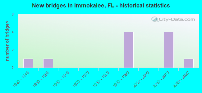
- New bridges - historical statistics
- 11940-1949
- 11950-1959
- 41990-1999
- 42010-2019
- 12020-2022


- Bridge Condition - Deck
- 33.3%Excellent
- 33.3%Very good
- 33.3%Good

- Bridge Condition - Superstructure
- 33.3%Excellent
- 33.3%Very good
- 33.3%Good

- Bridge Condition - Substructure
- 66.7%Good
- 33.3%Fair

- Bridge Condition - Channel
- 11.1%Excellent
- 11.1%Very good
- 66.7%Good
- 11.1%Fair

- Bridge Condition - Culverts
- 83.3%Good
- 16.7%Satisfactory
Find on map >> Show street view
Structure Number: 3014, Location: 6.5 MILES E OF SR 29 (Lat: 26.421994, Lng: -81.305022), Route carried "on" structure: County highway 846, Year Built: 1948, Status: Open, Structure Length: 3.69m (12.11ft), Average Daily Traffic: 3,200 (year 2021), Truck Traffic: 5%, Average Future Daily Traffic: 3,840 (year 2041), Design Load: HS 15, Features Intersected: DRAINAGE CANAL
Minimum Vertical Clearance: 30+ m (98+ ft), Kilometerpoint: 10.387, Lanes on structure: 2, Owner: County Highway Agency, Approaching Roadway Width: 6.3m (20.7ft), Material/Design: Concrete, Design/Construction: Slab, Number Of Spans In Main Unit: 8, Length of Maximum Span: 4.6m (15.1ft), Curb or Sidewalk Widths: Left: 0.4m (1.3ft), Right: 0.4m (1.3ft), Curb-To-Curb Width: 7.3m (24.0ft), Out-to-Out Width: 8.5m (27.9ft)
Condition: Deck: Good, Superstructure: Good, Substructure: Fair, Channel: Good, Operating Rating: 42.2 metric tons, Method Used To Determine Operating Rating: Load Factor (LF), Inventory Rating: 25.2 metric tons, Method Used To Determine Inventory Rating: Load Factor (LF), Structural Evaluation: Somewhat better than minimum adequacy, Deck Geometry: High priority of replacement, Waterway Adequacy: Better than present minimum criteria, Approach Roadway Alignment: Equal to present desirable criteria, Designated Inspection Frequency: Every 24 months, Inspection Date: April 2021, Deck Structure Type: Concrete Cast-file-Place, Wearing Surface/Protective System: Wearing Surface: Bituminous
Find on map >> Show street view
Structure Number: 30304, Location: 3.5 MI S of CR-846 (Lat: 26.389111, Lng: -81.376028), Route carried "on" structure: State highway 29, Year Built: 1999, Status: Open, Structure Length: 0.66m (2.17ft), Average Daily Traffic: 6,900 (year 2020), Truck Traffic: 12%, Average Future Daily Traffic: 11,972 (year 2042), Design Load: HS 20+Mod, Features Intersected: Canal 304
Minimum Vertical Clearance: 30+ m (98+ ft), Kilometerpoint: 54.595, Lanes on structure: 2, Base Highway Network: Yes, Owner: State Highway Agency, Approaching Roadway Width: 10.1m (33.1ft), Material/Design: Concrete, Design/Construction: Culvert, Number Of Spans In Main Unit: 2, Length of Maximum Span: 3.3m (10.8ft)
Condition: Channel: Good, Culverts: Good, Operating Rating: 55.3 metric tons, Method Used To Determine Operating Rating: Load Factor (LF), Inventory Rating: 33.2 metric tons, Method Used To Determine Inventory Rating: Load Factor (LF), Structural Evaluation: Better than present minimum criteria, Waterway Adequacy: Superior to present desirable criteria, Approach Roadway Alignment: Equal to present desirable criteria, Designated Inspection Frequency: Every 24 months, Inspection Date: March 2020
Find on map >> Show street view
Structure Number: 30305, Location: 0.8 MI S OF CR-846 (Lat: 26.411772, Lng: -81.401114), Route carried "on" structure: State highway 29, Year Built: 1999, Status: Open, Structure Length: 0.96m (3.15ft), Average Daily Traffic: 6,900 (year 2020), Truck Traffic: 12%, Average Future Daily Traffic: 11,972 (year 2042), Design Load: HS 20+Mod, Features Intersected: Canal 305
Minimum Vertical Clearance: 30+ m (98+ ft), Kilometerpoint: 58.133, Lanes on structure: 2, Base Highway Network: Yes, Owner: State Highway Agency, Approaching Roadway Width: 12.9m (42.3ft), Material/Design: Concrete, Design/Construction: Culvert, Number Of Spans In Main Unit: 3, Length of Maximum Span: 3.3m (10.8ft), Curb or Sidewalk Widths: Left: 2.9m (9.5ft), Right: 0.0m
Condition: Channel: Good, Culverts: Good, Operating Rating: 75.2 metric tons, Method Used To Determine Operating Rating: Load Factor (LF), Inventory Rating: 45.1 metric tons, Method Used To Determine Inventory Rating: Load Factor (LF), Structural Evaluation: Better than present minimum criteria, Waterway Adequacy: Superior to present desirable criteria, Approach Roadway Alignment: Equal to present desirable criteria, Designated Inspection Frequency: Every 24 months, Inspection Date: March 2020
Find on map >> Show street view
Structure Number: 34139, Location: 8.2 MI. W/O SR 29 (Lat: 26.294025, Lng: -81.471672), Route carried "on" structure: County highway 858, Year Built: 2012, Status: Open, Structure Length: 4.11m (13.48ft), Average Daily Traffic: 24,170 (year 2020), Truck Traffic: 13%, Average Future Daily Traffic: 30,213 (year 2040), Design Load: HL 93, Features Intersected: CAMP KEAIS STRAND
Minimum Vertical Clearance: 30+ m (98+ ft), Kilometerpoint: 0.000, Lanes on structure: 4, Owner: County Highway Agency, Approaching Roadway Width: 27.7m (90.9ft), Skew: 30 degrees, Material/Design: Prestressed concrete, Design/Construction: Stringer/Multi-beam, Number Of Spans In Main Unit: 3, Length of Maximum Span: 13.7m (44.9ft), Curb or Sidewalk Widths: Left: 2.5m (8.2ft), Right: 0.0m, Curb-To-Curb Width: 27.7m (90.9ft), Out-to-Out Width: 32.2m (105.6ft)
Condition: Deck: Excellent, Superstructure: Excellent, Substructure: Good, Channel: Good, Operating Rating: 44.7 metric tons, Method Used To Determine Operating Rating: Load and Resistance Factor (LRFR), Inventory Rating: 36.3 metric tons, Method Used To Determine Inventory Rating: Load and Resistance Factor (LRFR), Structural Evaluation: Better than present minimum criteria, Deck Geometry: Superior to present desirable criteria, Waterway Adequacy: Equal to present desirable criteria, Approach Roadway Alignment: Equal to present desirable criteria, Designated Inspection Frequency: Every 24 months, Underwater Inspection Frequency: Every 24 months, Inspection Date: April 2020, Underwater Inspection Date: April 2020, Deck Structure Type: Concrete Cast-file-Place
Find on map >> Show street view
Structure Number: 34177, Location: 8.6 MI W/O SR-29 (Lat: 26.294108, Lng: -81.479439), Route carried "on" structure: County highway 858, Year Built: 2012, Status: Open, Structure Length: 0.75m (2.46ft), Average Daily Traffic: 4,500 (year 2020), Truck Traffic: 18%, Average Future Daily Traffic: 5,625 (year 2040), Design Load: HL 93, Features Intersected: DRAINAGE CANAL
Minimum Vertical Clearance: 30+ m (98+ ft), Kilometerpoint: 0.000, Lanes on structure: 4, Owner: County Highway Agency, Approaching Roadway Width: 28.2m (92.5ft), Skew: 30 degrees, Material/Design: Concrete, Design/Construction: Culvert, Number Of Spans In Main Unit: 2, Length of Maximum Span: 3.9m (12.8ft), Curb or Sidewalk Widths: Left: 1.5m (4.9ft), Right: 0.0m
Condition: Channel: Good, Culverts: Good, Operating Rating: 54.5 metric tons, Method Used To Determine Operating Rating: Load and Resistance Factor (LRFR), Inventory Rating: 42.1 metric tons, Method Used To Determine Inventory Rating: Load and Resistance Factor (LRFR), Structural Evaluation: Better than present minimum criteria, Waterway Adequacy: Equal to present desirable criteria, Approach Roadway Alignment: Equal to present desirable criteria, Designated Inspection Frequency: Every 24 months, Underwater Inspection Frequency: Every 24 months, Inspection Date: January 2022, Underwater Inspection Date: January 2022
Find on map >> Show street view
Structure Number: 34801, Location: 7.5 MI E/O CR-846 (Lat: 26.294000, Lng: -81.475389), Route carried "on" structure: County highway 858, Year Built: 2012, Status: Open, Structure Length: 0.73m (2.40ft), Average Daily Traffic: 4,500 (year 2020), Truck Traffic: 18%, Average Future Daily Traffic: 5,625 (year 2040), Design Load: HL 93, Features Intersected: WILDLIFE CROSSING #1
Minimum Vertical Clearance: 30+ m (98+ ft), Kilometerpoint: 0.000, Lanes on structure: 4, Owner: County Highway Agency, Approaching Roadway Width: 27.3m (89.6ft), Skew: 30 degrees, Material/Design: Concrete, Design/Construction: Culvert, Number Of Spans In Main Unit: 1, Length of Maximum Span: 7.3m (24.0ft)
Condition: Channel: Very good, Culverts: Good, Operating Rating: 54.5 metric tons, Method Used To Determine Operating Rating: Load and Resistance Factor (LRFR), Inventory Rating: 42.1 metric tons, Method Used To Determine Inventory Rating: Load and Resistance Factor (LRFR), Structural Evaluation: Better than present minimum criteria, Waterway Adequacy: Superior to present desirable criteria, Approach Roadway Alignment: Equal to present desirable criteria, Designated Inspection Frequency: Every 24 months, Inspection Date: March 2020
Find on map >> Show street view
Structure Number: 34802, Location: 7.8 MI E/O CR-846 (Lat: 26.293889, Lng: -81.468833), Route carried "on" structure: County highway 858, Year Built: 2012, Status: Open, Structure Length: 0.73m (2.40ft), Average Daily Traffic: 4,500 (year 2020), Truck Traffic: 18%, Average Future Daily Traffic: 5,625 (year 2040), Design Load: HL 93, Features Intersected: WILDLIFE CROSSING #2
Minimum Vertical Clearance: 30+ m (98+ ft), Kilometerpoint: 0.000, Lanes on structure: 4, Owner: County Highway Agency, Approaching Roadway Width: 26.1m (85.6ft), Skew: 10 degrees, Material/Design: Concrete, Design/Construction: Culvert, Number Of Spans In Main Unit: 1, Length of Maximum Span: 7.3m (24.0ft)
Condition: Channel: Excellent, Culverts: Good, Operating Rating: 54.5 metric tons, Method Used To Determine Operating Rating: Load and Resistance Factor (LRFR), Inventory Rating: 42.1 metric tons, Method Used To Determine Inventory Rating: Load and Resistance Factor (LRFR), Structural Evaluation: Better than present minimum criteria, Waterway Adequacy: Superior to present desirable criteria, Approach Roadway Alignment: Equal to present desirable criteria, Designated Inspection Frequency: Every 24 months, Inspection Date: March 2020
Find on map >> Show street view
Structure Number: 34843, Location: 7.8 MI WEST OF SR-29 (Lat: 26.366528, Lng: -81.484583), Route carried "on" structure: County highway 846, Year Built: 2021, Status: Open, Structure Length: 3.20m (10.50ft), Average Daily Traffic: 4,799 (year 2021), Truck Traffic: 6%, Average Future Daily Traffic: 6,066 (year 2041), Design Load: HL 93, Features Intersected: GATOR CANAL
Minimum Vertical Clearance: 30.45m (99.90ft), Kilometerpoint: 40.927, Lanes on structure: 2, Base Highway Network: Yes, Owner: County Highway Agency, Approaching Roadway Width: 13.4m (44.0ft), Material/Design: Concrete, Design/Construction: Slab, Number Of Spans In Main Unit: 3, Length of Maximum Span: 10.7m (35.1ft), Curb-To-Curb Width: 13.4m (44.0ft), Out-to-Out Width: 14.2m (46.6ft)
Condition: Deck: Very good, Superstructure: Very good, Substructure: Good, Channel: Good, Structural Evaluation: Better than present minimum criteria, Deck Geometry: Better than present minimum criteria, Waterway Adequacy: Better than present minimum criteria, Approach Roadway Alignment: Equal to present desirable criteria, Designated Inspection Frequency: Every 24 months, Underwater Inspection Frequency: Every 23 months, Inspection Date: March 2021, Underwater Inspection Date: March 2021, Deck Structure Type: Concrete Cast-file-Place
Find on map >> Show street view
Structure Number: 39001, Location: 0.75 Mi. East of CR 18A (Lat: 29.968611, Lng: -82.380278), Route carried "on" structure: County highway , Year Built: 1955, Status: Open, Structure Length: 1.12m (3.67ft), Average Daily Traffic: 350 (year 2021), Truck Traffic: 10%, Average Future Daily Traffic: 607 (year 2042), Features Intersected: Five Mile Creek, Facility Carried by Structure: SW 63rd Drive
Minimum Vertical Clearance: 30+ m (98+ ft), Kilometerpoint: 1.223, Lanes on structure: 2, Owner: County Highway Agency, Approaching Roadway Width: 5.7m (18.7ft), Skew: 1 degrees, Material/Design: Concrete, Design/Construction: Culvert, Number Of Spans In Main Unit: 3, Length of Maximum Span: 3.7m (12.1ft)
Condition: Channel: Fair, Culverts: Satisfactory, Operating Rating: 64.0 metric tons, Method Used To Determine Operating Rating: Load and Resistance Factor (LRFR), Inventory Rating: 41.2 metric tons, Method Used To Determine Inventory Rating: Load and Resistance Factor (LRFR), Structural Evaluation: Equal to present minimum criteria, Waterway Adequacy: Better than present minimum criteria, Approach Roadway Alignment: Better than present minimum criteria, Designated Inspection Frequency: Every 24 months, Underwater Inspection Frequency: Every 24 months, Inspection Date: April 2021, Underwater Inspection Date: April 2021
Find on map >> Show street view
Structure Number: 39001, Location: 1.4MI SOUTH OF CR-846 (Lat: 26.404361, Lng: -81.393167), Route carried "under" structure: County highway , Year Built: 1992, Structure Length: 0. m, Average Daily Traffic: 100 (year 2020), Truck Traffic: 30%, Features Intersected: SR-29, Facility Carried by Structure: PANTHER PASS PED X
Minimum Vertical Clearance: 5.73m (18.80ft), Kilometerpoint: 0.000, Lanes under structure: 4, Material/Design: Steel, Design/Construction: Truss - Thru, Length of Maximum Span: 37.3m (122.4ft)
Find on map >> Show street view
Structure Number: 39001, Location: 1.4MI SOUTH OF CR-846 (Lat: 26.404361, Lng: -81.393167), Route carried "under" structure: State highway 29, Year Built: 1992, Structure Length: 0. m, Average Daily Traffic: 6,000 (year 2020), Truck Traffic: 18%, Features Intersected: SR-29, Facility Carried by Structure: PANTHER PASS PED X
Minimum Vertical Clearance: 5.73m (18.80ft), Kilometerpoint: 56.976, Lanes under structure: 4, Material/Design: Steel, Design/Construction: Truss - Thru, Length of Maximum Span: 37.3m (122.4ft)